appendix f lake lanier shoreline management plan - Mobile District ...
appendix f lake lanier shoreline management plan - Mobile District ...
appendix f lake lanier shoreline management plan - Mobile District ...

You also want an ePaper? Increase the reach of your titles
YUMPU automatically turns print PDFs into web optimized ePapers that Google loves.
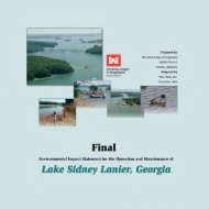
Final Environmental Impact Statement<br />
APPENDIX F<br />
LAKE LANIER<br />
SHORELINE MANAGEMENT PLAN<br />
Lake Sidney Lanier, Georgia November 2003
Final Environmental Impact Statement<br />
1. Purpose 4<br />
2. Objectives 4<br />
3. Authority 5<br />
4. Jurisdiction 5<br />
5. Authorized Project Purposes 5<br />
6. Project Statistics 6<br />
7. References 6<br />
8. Project Description and History 7<br />
9. Master Plan 7<br />
10. Preliminary Planning 8<br />
11. Public Involvement 8<br />
12. Private Boat Dock Carrying Capacity 9<br />
13. General Shoreline Allocation 10<br />
13.1 Prohibited Access Areas................................................................................11<br />
13.2 Protected Shoreline Areas ..............................................................................11<br />
13.3 Public Recreation Areas .................................................................................11<br />
13.4 Limited Development Areas............................................................................12<br />
14. Permits For Other Shoreline Uses 13<br />
14.1 Special Event Permits.....................................................................................13<br />
14.2 Specified Act Permits......................................................................................13<br />
14.3 Section 404 and/or Section 10 Permits...........................................................13<br />
14.4 Nationwide Permit...........................................................................................14<br />
15. Shoreline Use Permit/License 14<br />
15.1 Eligibility Requirements...................................................................................15<br />
15.2 Site Requirements ..........................................................................................16<br />
15.3 Floating and Landbased Facilities...................................................................18<br />
15.3.1 Floating Facility Types ..........................................................................18<br />
15.3.2 Dock Flotation.......................................................................................19<br />
15.3.3 Dock Structural-Support Systems.........................................................19<br />
15.3.4 Dock Ramps and Walkways .................................................................20<br />
Lake Sidney Lanier, Georgia F-1 November 2003
Final Environmental Impact Statement<br />
15.3.5 Dock Roofs and Sundecks....................................................................21<br />
15.3.6 Boat Hoists ...........................................................................................21<br />
15.3.7 Dock Storage Boxes .............................................................................21<br />
15.3.8 Dock Paint Coatings .............................................................................21<br />
15.3.9 Dock Anchoring.....................................................................................22<br />
15.3.10 Electrical Service ................................................................................22<br />
15.3.11 Pathways and Steps ...........................................................................23<br />
15.3.12 Water Lines and Pumps......................................................................24<br />
15.3.13 Telephones and Intercoms .................................................................24<br />
15.3.14 Furniture, Decorative Items and Garden Plants, Etc...........................24<br />
15.4 Facility Inspection Program.............................................................................25<br />
15.5 Dock Relocation/Access, Low Pool.................................................................25<br />
15.6 Facilities For The Disabled..............................................................................26<br />
15.7 Grandfathered Facilities..................................................................................26<br />
15.8 Land-Use Practices.........................................................................................26<br />
15.8.1 Erosion Control .....................................................................................26<br />
15.8.2 Land Formations...................................................................................27<br />
15.8.3 Exotic Species ......................................................................................27<br />
15.8.4 Chemical Agents...................................................................................27<br />
15.8.5 Fires......................................................................................................27<br />
15.8.6 Mowing or Bushhogging .......................................................................27<br />
15.8.7 Hazardous Trees ..................................................................................28<br />
15.8.8 Pest Control ..........................................................................................28<br />
15.8.9 Set-Back Zoning ...................................................................................28<br />
15.8.10 Licensed Roads ..................................................................................29<br />
15.8.11 Violation of Permit Conditions/Unauthorized use................................29<br />
15.8.12 Silt Removal........................................................................................30<br />
Lake Sidney Lanier, Georgia F-2 November 2003
Final Environmental Impact Statement<br />
16. Boundary Control 30<br />
18. Flowage or Flood Easements 31<br />
19. Buffer Zones 32<br />
20. Forest Management 33<br />
21. Wildlife Management 34<br />
22. Fisheries Management 34<br />
24. Wetlands 38<br />
25. Aquatic Plants 38<br />
26. Endangered Species 38<br />
27. Cultural and Historic Resources 39<br />
28. Island Management 39<br />
29. Leases 40<br />
30. Commercial Activity 40<br />
31. Regulatory Buoys 41<br />
32. Administrative Review 41<br />
33. Lake Lanier Focus Group 41<br />
34. Summary 42<br />
35. Exhibits 42<br />
Lake Sidney Lanier, Georgia F-3 November 2003
Final Environmental Impact Statement<br />
1. Purpose<br />
The purpose of the Shoreline Management Plan (SMP) is to furnish guidance for the<br />
<strong>management</strong>, protection, and preservation of the <strong>lake</strong>'s environment while allowing a<br />
balanced use of the Shoreline. However, the guidelines primarily address the private use of<br />
"Limited Development Areas' (LDA). The <strong>plan</strong> also considers means of restoration of the<br />
<strong>shoreline</strong> where excessive use, misuse or degradation may have occurred. During this<br />
update the name of the <strong>plan</strong> will be changed to the SMP as described in Corps<br />
regulations. Additionally, the use of modern technology, not available prior to this<br />
update, has been used to evaluate, locate and measure the geographical features of<br />
Lake Lanier. The corresponding changes are represented in this <strong>plan</strong> update.<br />
Please note that the text shown in bold print is new to the SMP. This was done to<br />
highlight the changes to the SMP and to allow the reader to readily identify these<br />
changes. The bold print will be removed in the final version of the SMP.<br />
2. Objectives<br />
The objectives of the SMP are:<br />
A. To insure availability and provide access to project lands and waters while<br />
maintaining the <strong>shoreline</strong> for general public use.<br />
B. To provide a level of recreational opportunities that does not overly impact<br />
project lands and waters.<br />
C. To promote a reasonably safe and healthful environment for project visitors.<br />
D. To respond to changing land and water conditions.<br />
E. To manage project lands in a manner that will conserve natural resources and<br />
environmental quality for future generations.<br />
F. To give special consideration for the protection of threatened and endangered<br />
<strong>plan</strong>t and animal species.<br />
G. To manage recreational and natural resources in a manner that is responsive to<br />
the general public.<br />
H. To reduce or prevent long-term damage or hazards from insect, animal, and other<br />
pests.<br />
I. To manage project <strong>shoreline</strong>s to properly establish, enhance, and maintain<br />
acceptable fish and wildlife habitat, aesthetic quality, and sustain natural<br />
environmental conditions.<br />
J. To provide public services through commercial sites and marinas.<br />
K. To preserve important historic, cultural, and natural aspects of our heritage.<br />
L. To manage private exclusive use of public property, in a manner that provides<br />
the least impact on public use.<br />
M. To establish a means of education and communication with the project user.<br />
N. To further provide for the protection of public land and water.<br />
Lake Sidney Lanier, Georgia F-4 November 2003
Final Environmental Impact Statement<br />
3. Authority<br />
This program has been prepared in accordance with the requirements of Engineering<br />
Regulation (ER) 1130-2-406, “Shoreline Management at Civil Works Projects”, originally<br />
dated December 13, 1974, amended October 31, 1990/September 14, 1992.<br />
4. Jurisdiction<br />
The Corps of Engineers has Proprietary or Managerial jurisdiction on Corps managed<br />
Federal lands. Under Section 234 of the Flood Control Act of 1970 certain project personnel<br />
may enforce CFR Title 36 part 327 (see Exhibit 11). Under Section 10 of the Rivers and<br />
Harbors Act of 1899, as amended and Section 404 of the Clean Water Act of 1977 certain<br />
Corps personnel may enforce portions of CFR Title 33 part 200. The State of Georgia and<br />
its political subdivisions retain statutory responsibility to enforce state and local laws.<br />
5. Authorized Project Purposes<br />
Congress authorized construction of Lake Lanier in 1946. It became the northern most link<br />
in a series of Corps of Engineers built <strong>lake</strong>s on the Chattahoochee, Apalachicola and Flint<br />
River systems. Construction was started in 1951 and completed in 1956 and the <strong>lake</strong> was<br />
fully operational in 1958. The projects current purposes are:<br />
1. Flood control-During times of heavy rainfall, run-off waters stored in the<br />
<strong>lake</strong> protect thousands of downstream homes, businesses and farmlands from<br />
flooding.<br />
2. Hydroelectric power production -Electricity produced by the powerhouse<br />
generators provides pollution free energy peak demand.<br />
3. Water supply and Water Quality -Water stored in the <strong>lake</strong> is the major<br />
water source for 50 % of the population of Georgia.<br />
4. Navigation -Water stored at Lanier can be released to increase downstream<br />
river depths allowing commercial barge navigation of the Lower Chattahoochee<br />
River.<br />
5. Recreation -Millions of visitors visit the project annually to enjoy the<br />
recreational opportunities the <strong>lake</strong> provides.<br />
6. Fish and Wildlife Management -The Corps of Engineers and Georgia<br />
Department of Natural Resources work jointly to implement <strong>management</strong> <strong>plan</strong>s<br />
to ensure protection and enhancement of these resources.<br />
Lake Sidney Lanier, Georgia F-5 November 2003
Final Environmental Impact Statement<br />
6. Project Statistics<br />
Lake Lanier is one of the Corps of Engineers most visited projects. From 1994 visitation has<br />
increased steadily from 6.7 million visitors to 7.8 million visitors in 2000. As metropolitan<br />
Atlanta expands northward usage continues to increase. Future projections for the regions<br />
population indicates continued growth.<br />
See Exhibit 2 for a complete list of project data. See Exhibit 2 for a detailed list of project<br />
statistical information.<br />
7. References<br />
A. National Environmental Policy Act of 1969, as amended<br />
B. Federal Water Pollution Control Act (Clean Water Act of 1977)<br />
C. Rivers and Harbors Appropriation Act of 1899, as amended<br />
D. Fish and Wildlife Coordination Act of March 10, 1934, as amended<br />
E. Endangered Species Act of 1973<br />
F. Public Law 86-717, 74 Statute 817, Forest Conservation<br />
G. Public Law 99-662, Section 1134(d), Water Resources Development Act of 1986<br />
H. Executive Order 11752, 'Prevention, Control, and Abatement of Environmental<br />
Pollution at Federal Facilities.'<br />
I. Code of Federal Regulations, Title 36, part 327 to end<br />
J. Code of Federal Regulations, Title 33, part 200 to end<br />
K. Engineer Regulation 405-1-12, chapter 8, Real Estate Handbook<br />
L. Engineer Regulation 1130-2-400, Management of Natural Resources and Outdoor<br />
Recreation at Civil Works Water Resource Projects<br />
M. Engineer Regulation 1130-2-406, Shoreline Management at Civil Works Projects<br />
N. SADVR 1130-2-12, Construction of Boat Launching Ramps by Non-Government<br />
Groups<br />
O. SADVR 1130-2-14, Use of Lakeshore Land and Water Areas for Minor Private<br />
Purposes<br />
Lake Sidney Lanier, Georgia F-6 November 2003
Final Environmental Impact Statement<br />
P. SAMOM 1130-2-2, Permitting Procedures for Private Floating Docks<br />
Q. MOBDR 1130-2-7, Permit System for Lakeshore Activities<br />
R. Master Plan, Lake Lanier 09/25/1987<br />
S. SAM SOP 1130-1-1, Resolution of Encroachments and Trespasses<br />
T. Environmental Impact Statement for Operations and Maintenance at Lake Sidney<br />
Lanier2002<br />
U. EP 1130-2-550 Project Operations - Recreation Operations and Maintenance Guidance<br />
and Procedures<br />
8. Project Description and History<br />
The Corps of Engineers has developed a Geographical Information System (GIS) to<br />
produce more accurate statistical data. This information is presented in this SMP<br />
update. As a result, Lake Sidney Lanier now has 39,038 surface acres at pool elevation<br />
1071 mean sea level (MSL). Due to Lanier's length and irregular shape it provides a<br />
<strong>shoreline</strong> of approximately 693 miles. Terrain surrounding Lake Sidney Lanier has rather<br />
strong relief with the greatest being to the north and northwest of the <strong>lake</strong>. The<br />
Chattahoochee River and its tributaries have cut deep ravines through the Piedmont Plateau<br />
producing numerous islands and promontories that offer superb vistas of the water and<br />
opposite <strong>shoreline</strong>. Streams flowing through the hilly, rugged terrain join to form a very<br />
irregular and interesting <strong>shoreline</strong>.<br />
The <strong>shoreline</strong> topography varies from rolling to steep. Portions of the <strong>shoreline</strong> <strong>plan</strong>ned for<br />
launching ramps, parking areas, picnic areas, swim areas and campgrounds have slopes<br />
varying from 5 to 12 percent. The balance varies from 5 to 30 percent with occasional<br />
steeper slopes.<br />
9. Master Plan<br />
The purpose of the Master Plan is to provide a comprehensive guide for orderly<br />
development of project resources in accordance with established laws, regulations, and<br />
policies. The first Master Plan, approved on April 29, 1965, established 83 public recreation<br />
areas.<br />
Lake Sidney Lanier, Georgia F-7 November 2003
Final Environmental Impact Statement<br />
Amended on February 24, 1967, this <strong>plan</strong> allocated 38 areas available for lease to certain<br />
quasi-public type organizations. Lake Lanier's current Master Plan was approved September<br />
25, 1987 after 8 years of development. Following approval of the Master Plan, a five year<br />
Operational Management Plan for natural resources and park <strong>management</strong> was developed<br />
by the field office. One of the many components of the Operational Management Plan is<br />
<strong>shoreline</strong> <strong>management</strong>.<br />
10. Preliminary Planning<br />
The regulation establishing the Lake Sidney Lanier SMP (ER 1130-2-406) was first<br />
approved in 1974 then updated in October 1990, September 1992 and May 1999. The<br />
development and implementation of Lanier's first SMP took place during 1975-76. Final<br />
approval of the <strong>plan</strong> by the State of Georgia and the South Atlantic Division Commander<br />
was received in 1979. The regulation also requires five (5) year reviews and periodic<br />
updates as necessary. During the 1984 review it became apparent that a major update was<br />
necessary. The updating of the 1979 <strong>plan</strong> was completed and approved by the South<br />
Atlantic Division Commander on January 28, 1988.<br />
During the years that followed, the SMP was reviewed without modification pending<br />
an update of the Lake Lanier Environmental Impact Statement (EIS) as required by<br />
the National Environmental Policy Act (NEPA). The initial Environmental Statement<br />
was completed in 1974 and is not inclusive of current <strong>plan</strong>s and operational conditions.<br />
A current EIS was considered crucial prior to the updating of the SMP. These two<br />
efforts, which are separate processes with separate goals, will complement and support<br />
each other to provide the Corps with current tools and documentation to help guide<br />
the <strong>management</strong> of Lake Lanier into the future. This updated SMP represents the<br />
<strong>shoreline</strong> <strong>management</strong> component of the preferred alternatives that have been<br />
evaluated and listed in the EIS.<br />
11. Public Involvement<br />
Notification was provided to the appropriate congressional delegations, local elected<br />
officials, and other Federal and State agencies responsible for various aspects of Lake<br />
Lanier. On September 20, 2001, the Corps of Engineers hosted a focus group meeting<br />
to initiate the public process. The focus group consisted of members representing a<br />
variety of backgrounds and interests including area residents, water quality experts,<br />
developers, <strong>lake</strong> related commercial interests, state and local government,<br />
environmental and special interest groups.<br />
The public process continued with three public meetings in the Lake Lanier area.<br />
Each public meeting was conducted as an open house allowing interested parties to<br />
attend between the hours of 1:00 pm and 9:00 pm. Participants were given focus<br />
group summaries and comment sheets to facilitate their feedback. Comments were<br />
Lake Sidney Lanier, Georgia F-8 November 2003
Final Environmental Impact Statement<br />
provided in person, by mail, and at the projects website. Public meetings were held at<br />
the following locations:<br />
Gainesville College Oakwood, GA, October 22, 2001<br />
Sawnee Center, Cumming, GA, October 25, 2001<br />
Gainesville Civic Center, Gainesville GA, Nov 7, 2001<br />
Following the public meetings and the preparation of the Preliminary Draft SMP a<br />
second focus group meeting was held on September 9, 2002. Additionally, the <strong>plan</strong> was<br />
reviewed by the Corps <strong>Mobile</strong> <strong>District</strong> office prior to being presented to the public in<br />
final draft form on November 19, 2002.<br />
12. Private Boat Dock Carrying Capacity<br />
In support of the SMP update and in conjunction with the EIS, a Private Boat Dock<br />
Carrying Capacity Study was completed. This study was conducted to examine the<br />
relationship between private boat dock permitting guidelines at the <strong>lake</strong> and future<br />
<strong>shoreline</strong> dock density. The study focused on one aspect of the future <strong>management</strong> of<br />
Lake Sidney Lanier: To determine the maximum number of private boat docks that<br />
could be permitted within limited development areas (LDA). The study, therefore,<br />
estimates the maximum number of private boat docks under a variety of different<br />
alternatives. The alternatives differ primarily in how boat docks are spaced along the<br />
<strong>shoreline</strong>. The purposes of the study were as follows:<br />
• To examine data related to current number and density of private boat docks on Lake<br />
Lanier.<br />
• To determine the effect of current Corps private dock permitting practices on LDAs.<br />
• To determine potential future <strong>lake</strong> condition based on different dock permitting<br />
scenarios.<br />
• To determine the potential number of boat docks the <strong>lake</strong> could accommodate in<br />
accordance with applicable regulations.<br />
• To suggest changes to SMP guidelines to ensure a healthy future <strong>lake</strong>.<br />
Based on the study <strong>management</strong> objectives were developed to include the total number<br />
of future boat docks. An evaluation of the entire Limited Development Shoreline<br />
zoning on Lake Lanier revealed that a total of 10,615 boat docks could be permitted.<br />
Lake Sidney Lanier, Georgia F-9 November 2003
Final Environmental Impact Statement<br />
Once the total number of docks (10,615) is reached no new permit requests will be<br />
accepted. Appropriate public notice will be issued before saturation is reached. It is<br />
anticipated that the historical average number of new permits issued each year (150)<br />
will remain constant. At this rate it could take ten years to reach the maximum 10,615<br />
permits identified in the Boat Dock Carrying Capacity Study.<br />
Scenario<br />
Table 2-14<br />
Summary of Future Dock Permitting Scenarios<br />
Number of Potential Potential<br />
Existing Additional Total<br />
Docks 1 Docks Docks<br />
Percent Change<br />
in Number of<br />
Docks<br />
No Action 8,593 16,734 25,327 195<br />
Preferred Alternative 8,593 2,022 10,615 24<br />
1 Includes 8,348 private boat docks and the equivalent of 245 boat docks in community docks.<br />
13. General Shoreline Allocation<br />
The increased use of public land and rapid development of adjacent private properties<br />
prompted the creation of the SMP. This <strong>plan</strong> is a guide for the protection, development, and<br />
balanced use of the <strong>lake</strong>'s <strong>shoreline</strong>. The <strong>plan</strong> has been developed in accordance with<br />
applicable regulations and policies. In part, the initial purpose of the SMP was to zone<br />
various segments of the <strong>shoreline</strong> to aid in the protection and orderly <strong>management</strong> of a<br />
diversely used resource. The <strong>shoreline</strong> allocations are depicted on map pages located at the<br />
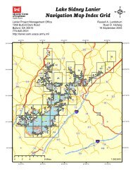
Operations Managers Office or at http://gis.sam.usace.army.mil<br />
Allocation 1<br />
Lake Lanier Shoreline Allocations<br />
(Elevation 1071 feet msl)<br />
Shoreline<br />
Length (miles)<br />
Percent of Total<br />
Shoreline<br />
Acres<br />
Percent of<br />
Project<br />
Property<br />
Limited Development Areas (LDA) 344.70<br />
LDA in water 1 9.13<br />
Total LDA 353.83 47.0% 6,186.6 34.9%<br />
Protected along main <strong>shoreline</strong> 177.44 23.6 5,079.8 28.6%<br />
Protected in water 3.14<br />
Protected along island <strong>shoreline</strong> 59.28 7.9% 1,083.9 6.1%<br />
Total Protected 239.86 31.9% 6,163.6 34.7%<br />
Recreation along main <strong>shoreline</strong> 136.80 18.2% 4,479.1% 25.2<br />
Recreation in water 0.28<br />
Lake Lanier Islands Resort islands 19.53 2.6% 850.4 4.8%<br />
Total Recreation 156.61 20.8% 5,329.5 30.0%<br />
Prohibited Areas 1.74 0.2% 64.9 0.4%<br />
Total Allocation 752.05 100.0% 17,744.6 100.0%<br />
Total Main Shoreline 2 692.77<br />
Total Island Shoreline 59.28 1,083.9<br />
Total Shoreline 752.05<br />
Total Lake Surface Area at 1,071 39,038.1<br />
Lake Sidney Lanier, Georgia F-10 November 2003
Final Environmental Impact Statement<br />
1<br />
“In water” refers to areas where the Corps boundary runs into the water. It is assumed that the <strong>shoreline</strong><br />
paralleling these segments is of the same allocation as the adjacent <strong>shoreline</strong> segments.<br />
2<br />
Includes Lake Lanier Islands Resort islands.<br />
To maintain a balance between public and private uses, areas presently allocated as<br />
"Public Recreation and Protected Shoreline" must be preserved and not converted to<br />
“Limited Development Areas”. As demands for recreation increases, these areas will<br />
be available for future development. Some of these areas may remain undeveloped,<br />
but even when left undisturbed, provide considerable value to the project for current<br />
and future generations. These values include, but are not limited to timber, wildlife,<br />
aesthetics, and natural areas for general public uses such as hiking, fishing or<br />
picnicking.<br />
13.1 Prohibited Access Areas<br />
This classification protects certain project operation areas and the recreational visitor.<br />
Although restricted visitation is allowed at most of these sites, Shoreline Use Permits are not<br />
issued for these locations. The only areas allocated under this classification are in the<br />
proximity of the powerhouse intakes, dam, saddle dikes, spillway, tailrace, and Corps<br />
marine yard. Less than two miles of <strong>shoreline</strong> is classified as "Prohibited Access". These<br />
areas are shown in orange on Exhibit 1.<br />
13.2 Protected Shoreline Areas<br />
Areas are designated "protected" to preserve the scenic appeal of a <strong>lake</strong> that has become<br />
urban; to avoid conflict between private and public uses; to protect specific habitat for fish<br />
and wildlife; to protect cultural historical, and archaeological sites; to protect endangered<br />
species; to protect navigation channels; to restrict placement of floating facilities in areas<br />
too shallow for navigation or too exposed to winds and currents; and to protect important<br />
natural formations and vistas.<br />
Passive recreational use is permitted along protected <strong>shoreline</strong> provided that aesthetic,<br />
environmental, historical, or natural resource values are not negatively impacted; however,<br />
private recreational facilities will not be authorized at these locations. Approximately 24<br />
percent of the <strong>shoreline</strong> is allocated in the "Protected" classification. Additionally, all<br />
islands with the exception of those leased to Lake Lanier Islands share this allocation<br />
zoning. These areas are shown in yellow on Exhibit 1. Public safety, environmental<br />
stewardship and sustainability are the Corps principal concerns along common boundaries<br />
fronting protected <strong>shoreline</strong>.<br />
13.3 Public Recreation Areas<br />
Although most of the project is considered available for limited recreational purposes,<br />
specific areas are set aside for intensive recreational development and use. These sites<br />
include campgrounds, day-use parks, primitive or natural areas, lands leased to public<br />
Lake Sidney Lanier, Georgia F-11 November 2003
Final Environmental Impact Statement<br />
groups and other local, state or federal agencies for recreational use or development and<br />
marine services.<br />
Permits for private <strong>shoreline</strong> use facilities are not granted in public recreation areas.<br />
Commercial activity is prohibited in all of these areas without a permit. Authorization for<br />
any commercial activity is restricted to those sites currently designated for commercial<br />
purpose. These sites include the <strong>lake</strong>'s marinas, leased club sites and the Lake Lanier<br />
Islands complex. The Corps primary <strong>management</strong> concerns in public recreation areas are to<br />
provide sites suitable for quality recreational experiences with facilities that can sustain<br />
intensive use, are vandal resistant, reasonably safe, and large enough to support normal<br />
weekend use during the peak recreation season. Locations of these sites are shown in red on<br />
Exhibit 1. Approximately 21 percent of the <strong>shoreline</strong> is classified as 'Public Recreation".<br />
13.4 Limited Development Areas<br />
Specific private uses of public lands may be permitted along <strong>shoreline</strong> designated 'Limited<br />
Development" as identified on Exhibit I. Permit applications will be considered individually<br />
on their own merits utilizing SMP guidelines. Comparisons to other existing situations are<br />
not practical due to the evolution and changes in public laws, regulations, and policies. The<br />
issuance of a Shoreline Use Permit/License does not preclude use of the <strong>shoreline</strong> by the<br />
general public. However, personal properties authorized for placement are the permittee's<br />
private belongings. Unauthorized intrusion upon private floating facilities or picnic shelters<br />
is considered a trespass and could be reported to the proper local authorities. However,<br />
pedestrian traffic and general public use of the <strong>lake</strong> and <strong>shoreline</strong> cannot be restricted or<br />
denied. Permit holders who attempt to preclude such uses are in violation of permit<br />
conditions and are subject to enforcement action as well as permit revocation requiring<br />
removal of all previously authorized facilities.<br />
Approximately 47 percent of <strong>shoreline</strong> is classified as 'Limited Development'. These areas<br />
are shown in green on Exhibit 1.<br />
Lake Sidney Lanier, Georgia F-12 November 2003
Final Environmental Impact Statement<br />
14. Permits For Other Shoreline Uses<br />
As with any large multi-use facility the demand for space on Lake Lanier must be regulated<br />
to encourage proper utilization and promote public safety. It is the intent of this section to<br />
describe the activities that are allowed and what permits are applicable other than those<br />
authorized by a Shoreline Use Permit/License. All permit requests are subject to review<br />
and may be granted only if public law and regulatory guidance are met and do not<br />
violate the Corps commitment to environmental stewardship and sustainable<br />
<strong>management</strong> principles.<br />
14.1 Special Event Permits<br />
Special Event Permits are required for recreational use of the project when more than 25<br />
persons or vessels are involved in a proposed activity. Generally speaking it is not the intent<br />
of this program to deny use of the project. It is, however, necessary to insure that<br />
environmental issues are addressed; that regulatory guidance is reviewed; that public safety<br />
is considered; that space is available; that the rights of others are not effected; and that the<br />
activity can in-fact be authorized. Permits issued by the Corps for special events do not<br />
relieve the permittee from obtaining similar local or state authorization, if required.<br />
Examples of special events permits are sailing regattas, fishing tournaments, company or<br />
corporate outings, water ski demonstrations, etc. Fees may be assessed.<br />
14.2 Specified Act Permits<br />
Specified Act permits may be granted to perform certain one-time only acts of a minor<br />
nature such as removal of hazardous trees, exotic <strong>plan</strong>ts such as kudzu or English ivy, or<br />
noxious <strong>plan</strong>ts such as poison oak/ivy, or sumac; <strong>plan</strong>t native species; establish footpaths;<br />
etc. The permit will detail the authorized work including the methods to be employed, time<br />
frames, location, equipment to be used if any, and restoration of public land if necessary. A<br />
drawing or <strong>plan</strong> including photographs may be required. The Specified Acts Permit is<br />
issued for short term only. Specified Act Permits are not issued for activities that will<br />
damage, destroy or significantly alter public lands. Each request for a Specified Acts Permit<br />
will be reviewed based on environmental law and regulation and authorization will be based<br />
upon the projects own merits.<br />
14.3 Section 404 and/or Section 10 Permits<br />
Lake Lanier is considered both Waters of the State of Georgia and Waters of the United<br />
States. Permits are issued pursuant to the authority granted under Section 404 of the Federal<br />
Water Pollution Control Act (Clean Water Act) and Section 10 of the Rivers and Harbors<br />
Appropriation Act of 1899, as amended. All requests are subject to the Endangered Species<br />
Act, the National Environmental Policy Act, and the Fish and Wildlife Coordination Act.<br />
Certain activities such as dredging, riprapping, construction of outfall lines, intake<br />
structures, other fixed structures, fill and the discharge of dredged or fill material, etc., into<br />
either navigable waters or waters of the U.S. may be permitted in accordance with CFR<br />
Lake Sidney Lanier, Georgia F-13 November 2003
Final Environmental Impact Statement<br />
Title 33 parts 322 & 323 provided it is not prohibited by CFR Title 36 part 327, the<br />
<strong>shoreline</strong> <strong>management</strong> <strong>plan</strong>, environmental law, or the public review process.<br />
Lake Lanier, as well as the other <strong>Mobile</strong> <strong>District</strong> water resource development projects<br />
within the state of Georgia, is granted Regional Authority to issue permits by the Savannah<br />
<strong>District</strong> Regulatory Functions Branch. The Savannah <strong>District</strong> Engineer has issued 16<br />
regional permits that can be issued by the Operations Manager for minor structures and<br />
activities in waters of the United States if authorized by the SMP.<br />
Regulatory permitting is completed pursuant to Section 10 of the Rivers and Harbors Act of<br />
1899 and Section 404 of the Clean Water Act of 1977. Typically, permits are issued for<br />
<strong>shoreline</strong> stabilization and dredging activities that are performed by adjacent landowners<br />
and are characterized as minor in nature. Applications for permits must contain <strong>plan</strong>s<br />
and specifications that sufficiently depict the actions requested and clearly indicate<br />
that work will be performed in compliance with permit conditions. Regional permit<br />
requests can be considered for each adjacent landowner, however, work performed<br />
under previous permits for similar actions nearby should be considered for consistency<br />
and compatibility. For this reason, riprap is the preferred method of <strong>shoreline</strong><br />
stabilization. Sea walls and gabion baskets will be considered only when rip-rap is not<br />
a functional alternative.<br />
Individual and nationwide permits are used to authorize projects that exceed the Regional<br />
Permits limitations. These activities include large scale dredging projects to a single entity<br />
and structures that require dredging or <strong>shoreline</strong> stabilization. Individual and nationwide<br />
permits require coordination with project staff and the North Area Section Office of the<br />
Savannah Regulatory Functions Branch. Pre-construction meetings often identify potential<br />
controversy and allow the applicant to anticipate potential impacts. All applications for<br />
work on Lake Lanier must be submitted to the Lanier Project Management Operations<br />
office. Exhibit 7 provides more detail of items possibly permitted under Sections 404 and<br />
10.<br />
14.4 Nationwide Permit<br />
The authority to initiate permits for activities of a minor nature relative to Section 404 and<br />
Section 10 Permits (item 13.3) has been delegated to Corps field offices. The parameters<br />
have been established in CFR Title 33 and are implemented through the Specified Acts<br />
Permit form. Violations of the permit are generally addressed through CFR Title 36 as petty<br />
offenses. Restoration and/or restitution are also employed as a means of corrective action.<br />
15. Shoreline Use Permit/License<br />
This is a temporary permit used to authorize specific private use of public <strong>shoreline</strong><br />
designated as "Limited Development". Authority to issue these permits has been delegated<br />
to the Operations Manager and is issued for the purpose of recreational use only.<br />
Permittees must remain in compliance with the terms and conditions of the permit, the<br />
Lake Sidney Lanier, Georgia F-14 November 2003
Final Environmental Impact Statement<br />
Shoreline Management Plan, SAM-SOP-1130-1-1, ER 1130-2-406, and Code of Federal<br />
Regulations Title 36 Section 327 to remain valid. A list of facilities that can be<br />
authorized is identified in Exhibit 9.<br />
15.1 Eligibility Requirements<br />
Permits may be issued in “Limited Development” areas only. The permit will be issued for<br />
a maximum of a five-year period. The permit may be reissued when the current term<br />
expires if the permitted facilities and uses of public land are in compliance with the<br />
conditions of the permit. Permits are non-transferable. They become null and void upon<br />
sale or transfer of the property associated with the permitted facilities or the death of the<br />
permittee. New owners must notify the Operations Managers office of their purchase<br />
and make application for a new permit<br />
To reduce environmental impacts to public property, community docks are now the<br />
preferred method of <strong>shoreline</strong> access and boat moorage. Community docks focus<br />
<strong>shoreline</strong> facilities in the most desirable location taking advantage of maximum water<br />
depth, slopes used for access and allow for the protection of important natural<br />
features. Property owners benefit from an upfront knowledge of the available<br />
permitted actions and can pursue completion without the delays associated with<br />
individual permitting. This concept supports local municipal zoning ordinances<br />
requiring “ Planned Community Developments” or PUD “Planned Unit<br />
Developments”.<br />
For this reason, community docks are required for all new residential developments<br />
where their use would reduce negative environmental impacts and provide greater<br />
protection of public land. New residential developments are defined as a property or<br />
properties receiving final plat approval after the implementation date of this <strong>plan</strong>. If<br />
the development is a PUD then community docks will be required. When evaluating<br />
requests for new docks the total <strong>shoreline</strong> frontage associated with the private<br />
property will be identified. If the multi-slip facilities can be accommodated within 20<br />
percent or less of the total leaving 80 percent or more to be rezoned as protected<br />
<strong>shoreline</strong>, a community dock will be required. Requests that do not meet this guidance<br />
can be further evaluated based on their environmental benefits and public interest. If<br />
site conditions prohibit the use of a community dock the Operations Manager may<br />
permit a variance for the use of private individual docks. It is not intended that this<br />
use be applied to an existing isolated lot. A community dock is intended to provide<br />
access to property owners, who would have otherwise qualified for a private individual<br />
dock under the guidance set forth in this <strong>plan</strong>.<br />
Following the issuance of a community dock permit the remaining <strong>shoreline</strong> and<br />
adjacent public property will be rezoned as “Protected”. No new private boat dock<br />
facilities will be permitted at these locations. The Corps will encourage existing<br />
private dock permittees in previously developed areas who are desiring to replace<br />
facilities to use community docks when appropriate. The use of a community boat<br />
ramp with a courtesy dock may be substituted for multi-slip docks to provide <strong>lake</strong><br />
Lake Sidney Lanier, Georgia F-15 November 2003
Final Environmental Impact Statement<br />
access to more of the residents. However, parking facilities and boat storage will be<br />
maintained on private property.<br />
Property owners may establish an association for a jointly owned courtesy facility on<br />
public land where private lands provide common access to public property. Such<br />
facilities are for all residents of the subdivision. Floating facilities authorized through<br />
associations are for courtesy use only, not for overnight storage or mooring purposes.<br />
Courtesy docks may not exceed 192 square feet.<br />
Site appointments are required with an area ranger prior to the issuance of a permit<br />
for private docks and related facilities. Appointments will be scheduled through the<br />
Operations Managers Office. During the appointment rangers will evaluate the<br />
location and facilities requested and provide an application package if site<br />
requirements are met (see section 15.2 Site Requirements). The location of facilities<br />
will be identified and reserved for a 90-day period from the date of the appointment.<br />
If applications are not received with in this period the site will no longer be reserved.<br />
Once the application package is received the eligibility requirements will be evaluated,<br />
if all criteria are met then the facilities requested will be authorized by permit.<br />
For those individuals who may qualify for private dock permits the following<br />
requirements apply. Individual lots must have a minimum of 82 feet of private land<br />
adjoining public property. This frontage must provide unrestricted legal access to<br />
public lands that are zoned "Limited Development". This requirement is not<br />
intended to apply to existing platted lots previously eligible for permit unless modified.<br />
Proof of the required access may be satisfied by submitting either a copy of a recorded deed<br />
containing an adequate legal description or notarized closing statement. Either document<br />
must be accompanied by the current property plat. Failure to provide proof of<br />
ownership, access, and a plat will result in denial of a request.<br />
Only one dock permit will be allowed per household. Multiple persons listed on a deed will<br />
be considered as one adjacent landowner and therefore ineligible for new permits. Permits<br />
will be issued on a first applicant basis. Permits are not issued for speculative purposes,<br />
enhancement of private property or to persons renting private property. The permittee must<br />
be the primary user and owner of facilities permitted. Permits are not issued to minors.<br />
Permits are temporary in nature with termination dates. The issuance of a permit is a<br />
privilege and does not infer private ownership or rights to public lands. Under no<br />
circumstances should any individual proceed with installation of facilities until a valid<br />
permit is in hand. Structures placed on public lands via a Shoreline Use Permit/License<br />
are private property on public lands authorized only for the term of the permit.<br />
15.2 Site Requirements<br />
Proposed locations for placement of facilities via permit must conform to the SMP and<br />
Allocation Map (Exhibit I). This map identifies the zoning of all public lands. New<br />
facilities will be considered in "Limited Development" <strong>shoreline</strong> only. Additionally, the<br />
Lake Sidney Lanier, Georgia F-16 November 2003
Final Environmental Impact Statement<br />
location of the proposed facilities must not cause a safety hazard to the applicant/user or<br />
general public. Shoreline stabilization measures (rip-rap) may be required with the<br />
issuance of new permits that require fixed steps or are located on sites already<br />
significantly affected by erosion. Regional permit authority for steps is limited to a<br />
maximum of 20 feet in length and not extend more than 10 feet <strong>lake</strong> ward from the top<br />
of the bank (see Exhibit 4). Shoreline areas that require more than the maximum<br />
length of steps will be considered unsafe and grounds for permit denial and rezoning.<br />
The selected site for any floating facility must be at the nearest point of <strong>shoreline</strong> to the<br />
adjacent owner's private property. Distance to the nearest point on water has no bearing on<br />
the issuance or denial of a permit. Deviations of not more than one hundred (100) feet left or<br />
right of this point may be considered if water depth or spacing is a problem. However,<br />
placement should not be made that would produce a crossing or crossover situation;<br />
meaning that an applicant's facilities should not go beyond existing neighboring facilities.<br />
Crossover situations cause community discord and therefore, will not be authorized.<br />
Private property lines do not extend onto public lands and do not indicate rights or<br />
privileges to or on government property not afforded any other member of the general<br />
public; nor does adjacent land ownership guarantee privacy or imply exclusive use of public<br />
<strong>shoreline</strong>.<br />
The proposed location for any new floating facility must provide at least a fifty foot<br />
(50) foot buffer area between existing or proposed structures at full pool elevations.<br />
This buffer is from the nearest point of one facility to the nearest point of the second<br />
facility and applies to across cove situations as well.<br />
In an effort to provide for safe navigation, reduce potential environmental damage,<br />
and improve aesthetics, the length of a vessel allowed at a private dock will be<br />
determined by length of the dock, mooring safety requirements and site conditions.<br />
Generally, boats that create blind spots, diminish boating safety, or exceed the docks<br />
ability to safely moor and protect from storm damage must be stored in marina<br />
facilities. Permittees may not rent out moorage space on private docks and in no case<br />
shall a vessel be moored to another vessel.<br />
All intended boat-mooring sites will allow for six (6) feet of water under the dock at the<br />
dock's <strong>lake</strong>side or slip end to prevent damage to boating equipment and to allow for<br />
water fluctuation. This requirement is subject to change based on the outcome of the<br />
ACT and ACF Water Allocation Compact Study and its effects on the future <strong>lake</strong><br />
levels at Lake Lanier.<br />
At locations selected for private floating facility the center one-third of the cove or channel<br />
must be left open for navigation. Community docks require one half of the cove be left<br />
open for navigation. At no time may the length of any dock including any moored vessel<br />
extend into this protected navigation channel at full pool elevation. Corps policy is to<br />
regain this navigable space when considering replacement facilities under existing permits.<br />
All new facilities will be placed or replaced in such a way as to have the least impact on<br />
navigation. During periods of low water navigation channels will not be obstructed.<br />
Lake Sidney Lanier, Georgia F-17 November 2003
Final Environmental Impact Statement<br />
Permits may not be issued in "Limited Development" zoned locations where endangered<br />
species exist, at cultural or historic sites, areas where the <strong>shoreline</strong> slope can not be<br />
accessed with the maximum authorized fixed steps, or in areas determined to be wetlands<br />
in accordance with CFR Title 33. Such locations will be rezoned to 'Protected' <strong>shoreline</strong>.<br />
15.3 Floating and Landbased Facilities<br />
The Operations Manager is authorized to issue a Shoreline Use Permits/License for a<br />
floating facility, utility rights-of-way, improved <strong>shoreline</strong> access, etc. For a complete list of<br />
the items currently authorized as well as those "Grandfathered" see Exhibit 9.<br />
15.3.1 Floating Facility Types<br />
In accordance with ER 1130-2-406 floating facilities will be permitted for the purpose of<br />
docking or mooring a vessel for private, not commercial use. It is important to note that the<br />
permit calls for a floating facility not fixed or suspended and the permit is issued for the<br />
purpose of boat storage and related boating apparatus only.<br />
Private floating facilities eligible for permitting are as follows:<br />
Boat dock: A structure with or without a roof, without sides/walls (completely enclosed)<br />
unless existing and grandfathered, with a storage slip(s) for docking or mooring a vessel.<br />
Such structures will not exceed a maximum dimensions of 32’ X 32’. The aggregate slip<br />
size will not exceed 20’(feet wide) by 28’ (feet long). Walkways must be a minimum of 4’<br />
wide. The maximum dimension will include any platform/deck added or constructed to the<br />
docking facility. The maximum dimension of any attached platform/deck will not exceed<br />
192 square feet. For the purposes of determining width from length on any type of floating<br />
facility, width will always be that portion parallel to the <strong>shoreline</strong>; length will always be that<br />
portion perpendicular to the <strong>shoreline</strong>. NOTE: The smallest dock to be permitted will be no<br />
smaller than 18’ X 24’ feet providing a 10’ X 20’ foot slip. All new dock construction will<br />
be open-sided (without sides/ walls) due to inspection requirements; unauthorized use and<br />
storage (indicating human habitation and unsanitary conditions); reduced visual obstruction<br />
to <strong>shoreline</strong> esthetics; and reduced storm and wind damage to the structure. A roof with<br />
straight-line design and minimum pitch from the centerline ridge is recommended. Roof<br />
decks will be allowed, but structural integrity is critical when covered with furniture and<br />
occupied by several persons (cases of collapse have been recorded).<br />
Platform/T-dock: no permits for private use will be issued for new platform/T-Docks<br />
due to safety concerns and general unsuitability as a mooring facility. Existing docks<br />
of this configuration that are currently authorized under permit will not be affected by<br />
this change in policy.<br />
Mooring Buoys: Although provisions for mooring buoys are provided in ER 1130-2-406,<br />
these are no longer permitted on Lake Lanier due to the demand for public space and<br />
previous safety problems caused by their presence.<br />
Lake Sidney Lanier, Georgia F-18 November 2003
Final Environmental Impact Statement<br />
15.3.2 Dock Flotation<br />
Flotation material is a substance used to float a mooring facility on the waters surface.<br />
Floats and the flotation material for all docks and boat mooring buoys shall be fabricated of<br />
materials manufactured for marine use. The float and its flotation material shall be 100%<br />
warranted for a minimum of 8 years against sinking, becoming waterlogged, cracking,<br />
peeling, fragmenting, or losing beads. All floats shall resist puncture and penetration and<br />
shall not be subject to damage by animals under normal conditions for the area. All floats<br />
and the flotation material used in them shall be fire resistant. Any float which is within 40<br />
feet of a line carrying fuel shall be 100% impervious to water and fuel. The use of new or<br />
recycled plastic or metal drums or non-compartmentalized air containers for encasement or<br />
floats is prohibited. For any floats installed after the effective date of this specification,<br />
repair or replacement shall be required when it or its flotation material no longer performs<br />
its designated function or it fails to meet the specifications for which it was originally<br />
warranted.<br />
15.3.3 Dock Structural-Support Systems<br />
Materials commonly used for joist’s, rafters. studding and decking are wood and/or metal.<br />
All wood shall be pressure treated with environmentally friendly chemicals, arsenic<br />
treated wood materials are prohibited. Metal decking is discouraged due to repair<br />
difficulties and slip hazards once the metal becomes damp from mud, rain, ice or snow.<br />
Metal should primarily be used for support functions not decking. Metal decking, if used,<br />
must be designed for this purpose and have a nonskid tread.<br />
Wood construction is considered unsafe when nails, bolts, or screws are protruding to cause<br />
a trip hazard; when materials become partially decayed or slick from use; when materials<br />
become ripped, jagged, pointed, splintered from wind or other factors; when wood supports<br />
and decking become loose or missing, when wooden materials protrude beyond the defined<br />
limits of the structure's approved dimensions.<br />
Metal construction is considered unsafe when it becomes pointed, sharp or jagged from<br />
wear, rust or wind damage; when bolts, screws, etc., become loose causing a trip hazard or<br />
allowing the structure to become partially unstable; when metal joints lose structural<br />
strength due to broken welds or rust; when metals protrude beyond the defined limits of the<br />
floating facility's approved dimensions; or when portions of metal decking is missing. Under<br />
these and other unsafe conditions the permittee must repair, remove and/or replace the<br />
facility in accordance with current standards.<br />
Permitted facilities and activities are subject to periodic inspection by authorized Corps<br />
representatives. The Operations Manager will notify the permittee of any deficiencies<br />
and establish a reasonable schedule for their correction. No deviation or changes from<br />
approved <strong>plan</strong>s will be allowed without prior written approval of the Operations Manager.<br />
Lake Sidney Lanier, Georgia F-19 November 2003
Final Environmental Impact Statement<br />
15.3.4 Dock Ramps and Walkways<br />
All dock ramps and walkways may be constructed of treaded metal, lumber treated with<br />
environmentally suitable chemicals, or marine products with skid resistant surfaces.<br />
Coverings such as carpet limit the inspection of the facility, promote decay, and create<br />
slippery surfaces. Due to these safety concerns carpet and other unsuitable coverings are<br />
prohibited and require removal.<br />
Unless otherwise approved dock walkways shall be at least four (4) feet, but not more than<br />
six (6) feet wide. Walkways less than four feet wide are not allowed due to safety<br />
considerations. However, walkways previously approved that are less than four feet wide or<br />
more than four (4) feet above the ground or water surface must have handrails 36-48 inches<br />
high with an intermediate guardrail approximately one-half the distance below the top rail.<br />
For the purpose of determining the dimensions of an attached platform, four feet of<br />
walkway adjacent to the slip is not considered a portion of the attached platform.<br />
Floating ramps leading to docks will not be less than four (4) nor more than six (6) feet in<br />
width nor exceed forty (40) feet in length. If land-based fixed steps are approved in<br />
conjunction with the approach ramp, the steps shall not exceed six (6) feet in width and<br />
be no longer than 20 feet in length (see section 15.2 “Site Requirements”). Because<br />
fixed piers obstruct <strong>lake</strong> access during low <strong>lake</strong> levels, no new authorizations will be<br />
granted. Additionally, ramps will not lead to the upper level/roof of a dock facility.<br />
Existing structures of this type will be grandfathered. All approach ramps four (4) feet<br />
above water or ground surface must have handrails 36-48 inches high with an intermediate<br />
guardrail approximately one-half the distance below the top rail. All safety rails must be<br />
made of continuous rigid material. All approach ramps must be floating unless otherwise<br />
approved by the Operations Manager. All floating facilities must have an approach ramp.<br />
The minimum approach ramp dimension is sixteen (16) feet long by four (4) feet wide.<br />
Walkways found to be in excess of the permitted length will generally require removal. If a<br />
determination is made that the existing length is required to meet the minimum depth<br />
standard of 6 feet at full pool and all other site requirements are in compliance an exception<br />
may be considered.<br />
All walking surfaces of floating facilities are considered unsafe when not structurally sound;<br />
having obstructions restricting the walking surface; when not kept free of carpet, protruding<br />
nails, screws, mud, grease, oils, soaps, or any material that would create a trip hazard; when<br />
not free from excessive spring, deflection, or lateral movement; when not supported by<br />
adequate flotation; when pieces or sections of decking are missing; Handrails are considered<br />
unsafe when toe-nail construction has been used; when handrails have been installed too<br />
low or too widely gapped to be effective; or any other condition that might make the<br />
walkway unsafe.<br />
Lake Sidney Lanier, Georgia F-20 November 2003
Final Environmental Impact Statement<br />
15.3.5 Dock Roofs and Sundecks<br />
Although roofs may be constructed to allow for an upper sundeck, applicants should be<br />
encouraged to erect floating facilities with gabled superstructure having the minimum<br />
possible pitch for the material used. Maximum slope shall not exceed 3(vertical) on 12<br />
(horizontal). Roofs may be constructed with either wood and shingle, or metal products. If<br />
an upper roof sundeck is constructed the entire rim of the upper structure's roof-deck must<br />
be enclosed with a continuous rigid retaining rail. The rails shall be 36-48 inches high with<br />
an intermediate guardrail approximately one-half the distance below the top rail. A<br />
permanent and/or fixed bench and rail combination may be constructed along the interior<br />
perimeter of the upper roof-deck. Single level roofs are authorized, however, any type of<br />
covering that establishes a second level roof or room, whole or in part is prohibited.<br />
Roofs are considered unsafe when there is material failure; when the substructure or<br />
superstructure is damaged, rotting, or not structurally sound; when the outer perimeter of the<br />
roof-deck is not completely enclosed; when safety rails are damaged, failing, or poorly<br />
constructed (toe-nail construction of safety rails is poor construction); when pieces or<br />
sections of decking or roofing are missing; when steps leading to the roof are poorly<br />
constructed, improperly affixed to the main dock structure not stable, etc., or any other<br />
condition that might make the roof unsafe.<br />
15.3.6 Boat Hoists<br />
Boat slips may contain floating or suspended hoists. Suspended boat hoists are only<br />
permitted when the applicant submits certified engineering drawings that guarantee the dock<br />
and lift capacity for the vessel being stored. Floating boatlifts must be attached to the<br />
substructure. All hoists and lifts must be constructed within the slip area with the exception<br />
of personal watercraft (PWC) floating hoist or lifts that allow the PWC to rest on the<br />
dock. A maximum of two hoists for PWC use outside of the slip may be authorized<br />
15.3.7 Dock Storage Boxes<br />
Enclosed storage on a floating facility will be limited to the maximum dimensions of 8 feet<br />
long, 4 feet wide, and 2.5 feet high. Storage boxes may not interfere with walk space. Dock<br />
storage boxes are authorized for storage of water related recreation equipment only. Boat<br />
docks are not to be used for general storage and no flammable liquids may be left<br />
unattended.<br />
15.3.8 Dock Paint Coatings<br />
Permittees are not required to paint metal or stain wood components of their facilities.<br />
However, if painted, colors such as dark browns black and dark greens that blend with<br />
the natural surroundings are required. Bright colors are not authorized. Wood<br />
surfaces may be left untreated to weather naturally.<br />
Lake Sidney Lanier, Georgia F-21 November 2003
Final Environmental Impact Statement<br />
15.3.9 Dock Anchoring<br />
An anchorage system shall be provided which will ensure secure anchoring of the floating<br />
facility taking into consideration the water depth, exposure to wave action, and wind.<br />
Shoreline trees or other natural features will not be used as anchors. To prevent stress,<br />
floating facilities will be anchored perpendicular to the <strong>shoreline</strong> with anchor cables placed<br />
at 45-degree angles to the <strong>shoreline</strong>. Anchor posts with sleeves resting on the <strong>lake</strong><br />
bottom may be used with out cables, however, if this is not sufficient, cable(s) will be<br />
required in conjunction with anchor post. A maximum of two (2) anchor post can be<br />
used provided they are installed on the <strong>shoreline</strong> side of the dock. The permit holder<br />
must ensure that floating facilities never become elevated above the ground or water, and<br />
prevent the loss of post during periods of <strong>lake</strong> level fluctuation. Anchor cables may be<br />
secured to the <strong>shoreline</strong> with metal or wooden posts, or screw augers placed so not to<br />
endanger visitors or damage vegetation. Metal anchor posts are preferred since additional<br />
grounding is afforded in case of electrical failure. Care should be exercised when installing<br />
metal anchor posts. If the metal post is driven into the ground, the metal may split or<br />
become jagged creating a safety hazard that must be corrected. The floating facility must be<br />
either floating or resting on the ground at all times.<br />
Anchor cables may not obstruct the public's use of the <strong>shoreline</strong> or water surface. Excessive<br />
cabling is not allowed if it blocks off an area for private use. Cables exceeding 45-degree<br />
angles may require reinstallation upon inspection. Cables shall be maintained in a taut<br />
condition. Cables shall not cross those of an adjacent facility. No other cable or anchoring<br />
devices will be permitted on the <strong>lake</strong> bottom. Cables may not be lined with Styrofoam or<br />
plastic jugs, etc. due to aesthetics. Floating facilities should not share the same anchor post.<br />
15.3.10 Electrical Service<br />
Current requirements for installation and use of electric service on public lands at Lake<br />
Lanier were adopted 27 Nov 85 (See Exhibit 3). This requirement slightly exceeds the<br />
National Electric Code (NEC). This standard insists that all convenience receptacles and<br />
lighting have ground-fault protections.<br />
Item "D-3" of the requirements advises that flexible cord types (those normally used for ship<br />
to shore power with twist lock connections) are to be used to tie service from the GFI to the<br />
dock.<br />
Light fixtures must be shielded or otherwise constructed so that residents or boaters are not<br />
blinded by the glare from lights. Dock lighting must not protrude beyond the floating<br />
facility structure and must be pointed downward.<br />
Regardless of the age, condition or Grandfathered provision, all electrical service must have<br />
GFI protection and be buried underground to meet requirements. Recertification is required<br />
at each permit renewal, change of ownership or at any time an inspection reveals that the<br />
service does not meet requirements. See Exhibit 3<br />
Lake Sidney Lanier, Georgia F-22 November 2003
Final Environmental Impact Statement<br />
15.3.11 Pathways and Steps<br />
Meandering pedestrian pathways may be created for access to the permitted facilities at no<br />
fee. Pathways will follow a meandering route that conforms to the topography as much as<br />
possible to help prevent erosion, avoid the need for removal of vegetation, and prevent the<br />
construction of bridges or steps. All work will be completed with hand tools only unless<br />
otherwise authorized in writing by the Operations Manager. If surface treatment is<br />
required to prevent erosion or fill depressions, wood chips or on-site forest litter are<br />
recommended. If erosion is evident due to continued foot traffic and water run off,<br />
intermittent water breaks may be necessary.<br />
If slopes prohibit safe access by means of a natural path then steps or a bridge creating the<br />
least environmental impacts may be authorized under permit with a fee. Materials used to<br />
create these structures must be properly treated and environmentally friendly, no<br />
wood treated with arsenic will be authorized. All steps must be constructed of at least<br />
8”wide x 6” high material without borders. Every effort should be made to prevent<br />
continuous running steps. Steps may not be elevated nor create a boardwalk. Steps or<br />
landings may not be erected in a manner to create patios. Unless the steepness of the slope<br />
dictates it or handicap needs demand it, steps should be constructed without handrails. All<br />
steps must be constructed at contour or ground level. If backfilling is required, the surface<br />
treatment must be wood chips or similar mulch. Landscape timbers are not authorized for<br />
step construction due to safety considerations.<br />
Footbridges may only be authorized if there are no other alternatives to provide safe access.<br />
Footbridges may not exceed four feet in width. All foot bridges more than four feet above<br />
the surface of the ground must have a handrail. The rails shall be 36-48 inches high with an<br />
intermediate guardrail approximately one-half the distance below the top rail. The pathway<br />
permit does not convey the right to use equipment or construct any other structure unless<br />
specifically authorized.<br />
Pedestrian access lighting may be installed underground following the meandering footpath.<br />
Permit holders are required to use mushroom style lighting, not to exceed a height of two<br />
feet (2). See Exhibit 3, "Requirements for Installation and Use of Electric Service on<br />
Government Property at Lake Lanier". Existing pathway lighting not meeting this<br />
standard will require replacement upon repair.<br />
Natural pathways are considered unsafe when the terrain is too steep to safely access the<br />
<strong>shoreline</strong>, thus requiring improved steps. Pathways must remain free of stumps, snags and<br />
other tripping hazards. Steps are considered unsafe and unauthorized when poorly placed or<br />
constructed so that the step is loose; or when materials are defective damaged, or decaying.<br />
Lake Sidney Lanier, Georgia F-23 November 2003
Final Environmental Impact Statement<br />
15.3.12 Water Lines and Pumps<br />
Water lines not-to-exceed 2" in diameter may be installed underground and must follow the<br />
access path. Water lines may be placed in the same trench as the electric line. Water lines<br />
may be installed to deliver fresh or raw water or both. Pumps associated with water lines<br />
must be electric, may not exceed two (2) horsepower and must be installed on the floating<br />
facility. Pumps and electrical components will not be submerged. Electrical service must<br />
conform to Exhibit 3. All water lines must be attached to the dock and/or ramp and may not<br />
be submerged. Water faucets may be placed on the dock and/or land. The installation of<br />
water faucets should be inconspicuous or low profile and must not exceed thirty (30) inches<br />
in height. Waterlines for the withdrawal and subsequent redelivery of water for the purposes<br />
of heat pump service is prohibited unless a National Pollutant Discharge Elimination System<br />
(NPDES) Permit has been obtained from the State of Georgia.<br />
No new landbased pump houses will be authorized. Removal of existing pump houses will<br />
be required if the facility is not a well-constructed shed type facility, the well is abandoned,<br />
or if the structure needs major repair.<br />
15.3.13 Telephones and Intercoms<br />
Telephone service may be authorized, however, use of cell telephones is encouraged.<br />
Telephone lines must be installed underground in the same trench as other electrical wiring.<br />
Intercom lines may be installed along with other electrical services.<br />
15.3.14 Furniture, Decorative Items and Garden Plants, Etc<br />
Docks are permitted for the purpose of providing moorage for vessels. However, it is<br />
recognized that docks may serve multiple purposes and may be used for fishing, sunbathing,<br />
or other leisure activities where furniture may be desired. Outdoor or patio type furniture<br />
may be used on upper or lower sundecks provided the furniture does not restrict or interfere<br />
with the walkways or otherwise cause a hazard. Four-foot wide dock sections are not<br />
considered adequate to accommodate furniture. Due to wind and wave action, dock owners<br />
are encouraged to securely attach furniture to the dock or remove it when not in use.<br />
Diving boards/structures of any type as well as sliding boards, hammocks and playground<br />
equipment are prohibited. Additionally, items such as indoor furniture or objects that<br />
denote habitation such as, but not limited to couches, sinks, cabinets, appliances, satellite<br />
dishes, security cameras and permanent stereo systems are prohibited.<br />
Outdoor furniture may be placed on 'grandfathered' picnic shelters and patios. However,<br />
outdoor furniture may only be placed on 'grandfathered' patios during actual use and may<br />
not be left more than 24 hours. Neither picnic shelters nor landbased boat shelters may be<br />
used or converted to storage shelters or habitable structures.<br />
Lake Sidney Lanier, Georgia F-24 November 2003
Final Environmental Impact Statement<br />
Decorative items, house and garden <strong>plan</strong>ts, Christmas trees and lights, signs, or banners<br />
and other similar commodities are prohibited on public land and on private facilities located<br />
on public property.<br />
15.4 Facility Inspection Program<br />
All permitted facilities must be operated, used and maintained by the permittee in a<br />
safe, healthful condition at all times. At the time of permit renewal, change of<br />
ownership or at the discretion of the Operations Manager all permittees will be<br />
required to contract the services of a Corps trained "candidate", or higher, level<br />
inspector, who has passed all written exams and continues to meet the requirements<br />
for either: the American Society of Home Inspectors (ASHI) or Georgia Association of<br />
Home Inspectors (GAHI). Inspectors will provide permit holders at a minimum, a<br />
Corps of Engineers inspection report that details the deficiencies found and the<br />
inspector’s final inspection and certification that the facilities are in full compliance of<br />
the permit conditions. Payment of costs associated with the inspection along with the<br />
submission of full application package including certifications will be the responsibility<br />
of the permit holder.<br />
In order to be Corps trained to perform facility inspections an individual will be<br />
required to attend an orientation session held at the Operations Managers Office. The<br />
orientation will acquaint inspectors with Corps requirements, boundary identification,<br />
and permit conditions. Required inspection and certification forms will be located on<br />
the Lake Sidney Lanier web site. See Exhibit 3<br />
Permittees who determine to replace their existing dock must request an appointment<br />
with their area ranger to discuss size and location. After the previous facility has been<br />
removed the replacement facility may be installed anytime within the five-year permit<br />
period.<br />
15.5 Dock Relocation/Access, Low Pool<br />
During periods of low <strong>lake</strong> levels floating facilities may be moved to follow the receding<br />
<strong>shoreline</strong> as long as one third of the channel remains open for navigation and safety is not an<br />
issue. Permittees have the option to move docks laterally but not beyond or crossing any<br />
neighboring facilities and not within the boundaries of "protected' or 'recreation" zoned<br />
<strong>shoreline</strong>. In locations where competition for space to keep docks afloat is a problem during<br />
low <strong>lake</strong> levels neighbors are encouraged to seek amicable solutions.<br />
Excavation, digging, leveling or changing the contour to access the <strong>lake</strong>bed without a permit<br />
is prohibited. Permanent placement of hoist to enable dock movement is prohibited. Access<br />
to the dock during periods of low <strong>lake</strong> levels must generally be gained through some<br />
temporary wooden means.<br />
Lake Sidney Lanier, Georgia F-25 November 2003
Final Environmental Impact Statement<br />
15.6 Facilities For The Disabled<br />
The Corps has developed a number of handicap facilities for <strong>lake</strong> access in public recreation<br />
areas that are in compliance with the Americans Disabilities Act (ADA). Adjacent<br />
landowners and permittees are encouraged to use these facilities when the need for<br />
disability access arises. If direct access to the dock is required from the adjoining<br />
property for a disabled resident, authorization for specialized facilities can be<br />
considered. Each case will be reviewed based upon its own merits. To qualify one<br />
must provide a doctors letter that describes the disability. The letter must provide<br />
sufficient detail concerning the disability and the type of access medically necessary for<br />
continued use of the facilities. Benches, handrails or use of a motorized cart or similar<br />
vehicle may be authorized. Authorization will be granted for the minimum<br />
improvements necessary to provide safe access. Temporary solutions will be<br />
considered for temporary disabilities. In any case the person requiring the access must<br />
reside full time in the home of the permittee. At renewal of the permit this need must<br />
be reestablished with a subsequent doctors letter. Because of the temporary nature of<br />
these permits hardened surfaces such as gravel, asphalt or concrete may not be<br />
authorized due to negative environmental impacts and the high cost of removal. Site<br />
conditions may limit the Corps ability to accommodate every applicant.<br />
15.7 Grandfathered Facilities<br />
A 'grandfathered' item is defined as an activity, facility or structure that was<br />
authorized under a previous policy and prior permit, but new permits are no longer<br />
issued for their construction. Existing permits will continue to be reissued for these<br />
items in protected/recreation areas as long as they are maintained in a usable and safe<br />
condition, not occasion a threat to life or property, and the permitee is in substantial<br />
compliance with the existing permit conditions. If the permitted facilities do not meet<br />
these requirements they must be removed and cannot be replaced.<br />
15.8 Land-Use Practices<br />
It is the policy of the <strong>Mobile</strong> <strong>District</strong> to authorize certain private uses of public lands when<br />
these uses or acts are compatible with the provisions of public law and regulation. Permits<br />
may be obtained to control erosion, <strong>plan</strong>t native species, reduce or eliminate noxious <strong>plan</strong>ts,<br />
aid in fire prevention, and remove hazardous trees etc.<br />
15.8.1 Erosion Control<br />
Erosion control methods such as <strong>plan</strong>ting of native vegetation or placing water breaks along<br />
footpaths to reduce rainwater runoff velocity may be authorized. Permits for <strong>shoreline</strong><br />
protection (rip rap) as addressed by Section 10 and 404 of the Clean Water Act and<br />
authorized by a Specified Acts Permits are also available at the Operation Managers Office.<br />
See section 14.3<br />
Lake Sidney Lanier, Georgia F-26 November 2003
Final Environmental Impact Statement<br />
Point-source sedimentation violations that directly impact Lake Lanier may be<br />
reported to the local government with jurisdiction, the Georgia Environmental<br />
Protections Division, or the Operation Managers’ office. The Operations Manager's<br />
authority is limited; therefore, local review would only determine the extent of damage<br />
and initiate contact with the appropriate enforcement element.<br />
15.8.2 Land Formations<br />
Land formations may not be modified without a permit.<br />
15.8.3 Exotic Species<br />
Exotic species or <strong>plan</strong>ts not native to the area are not authorized and must be removed.<br />
Flower and vegetable gardens are not authorized. Native vegetative species may be <strong>plan</strong>ted<br />
in a random or natural fashion and must be authorized by a Specified Acts Permit.<br />
15.8.4 Chemical Agents<br />
Broad uses of Chemical agents such as pesticides are not authorized. Chemical products<br />
such as pre-emergence, weed killers, fertilizers, growth retardant, etc., may not be used on<br />
public lands, however, some topical application to control noxious or nonnative species may<br />
be allowed under rigid control via a Specified Acts Permit. The use of such products on<br />
private property must not affect public lands or waters.<br />
15.8.5 Fires<br />
Fires or burning on the <strong>shoreline</strong> is no longer authorized on Corps managed lands regardless<br />
of the <strong>lake</strong> level. County burn permits do not authorize burning on Corps managed<br />
properties. Adjacent landowners may remove forest litter away from their residences not<br />
exceeding six feet in locations where residential structures were built close to the<br />
government property line.<br />
15.8.6 Mowing or Bushhogging<br />
Mowing and general lawn care of public land is not permitted. Presently, there are areas on<br />
public land where the adjacent landowner has maintained grassy areas in a lawn-like<br />
condition. These open areas generally evolved from agricultural practices that removed tree<br />
cover prior to land acquisition by the Government or from tree loss due to fires, diseases or<br />
other causes since impoundment of the <strong>lake</strong>. Adjacent landowners may continue<br />
maintaining these existing grassy areas provided a Shoreline Use Permit/License has been<br />
Lake Sidney Lanier, Georgia F-27 November 2003
Final Environmental Impact Statement<br />
issued to authorize the activity. Because grass is not a high quality vegetative buffer, it is<br />
project policy to restore grassy areas to a more natural state. When such areas are not<br />
maintained and woody vegetation has reestablished itself this portion of the permit will<br />
not be renewed. During changes of ownerships minimization of permitted mowed<br />
areas will be encouraged to help protect the <strong>lake</strong>s water quality. Adjacent landowners<br />
have the greatest impact and opportunity to protect or restore the <strong>lake</strong>s vegetative<br />
buffer.<br />
Authorized footpaths six (6) feet wide may also be maintained by mowing and limited<br />
underbrushing. Site <strong>plan</strong>s delineating the limits of cleared areas, underbrushing, or <strong>plan</strong>tings<br />
from the approved <strong>plan</strong>t list in Exhibit 8 will be developed on-site by the applicant and a<br />
Corps ranger.<br />
15.8.7 Hazardous Trees<br />
Hazardous trees that endanger life or property may be cut/dropped and/or removed from<br />
public land. Specified Act permits may be issued or the applicant advised in writing the<br />
reasons for denial. If the Corps is requested to fell hazardous trees any subsequent cleanup<br />
or removal of the tree may be authorized by permit to the adjacent landowner making the<br />
request.<br />
15.8.8 Pest Control<br />
Pest Control includes forest insects, pets or stray animals, rodents and other health related<br />
nuisances. Coordination between Corps and local government agencies is essential not only<br />
to reduce health hazards, but also to prevent endangerment to others as well as the resource.<br />
Naturally occurring wildlife species are not considered to be pests.<br />
15.8.9 Set-Back Zoning<br />
Set-Back building codes are absolutely necessary to prevent building errors or boundary<br />
discrepancy from becoming major encroachment problems. Local governments are strongly<br />
encouraged to pursue set-back zoning on the Corps boundary line. Such a policy will greatly<br />
reduce conflict between the general public, the Corps, and the neighboring landowners, as<br />
well as reduce the taxpayer’s share of costs necessary to protect public lands around Lake<br />
Lanier. It is recommended that a 15-foot setback be established and enforced. Setbacks of<br />
sufficient width are required so that construction of home sites will not require storage<br />
of excavated material, fill, construction materials or equipment on public lands.<br />
Lake Sidney Lanier, Georgia F-28 November 2003
Final Environmental Impact Statement<br />
15.8.10 Licensed Roads<br />
Private roads established under prior policy were authorized for <strong>shoreline</strong> access only and<br />
were not intended to be used for vehicle or vessel storage. These roads now have a<br />
Grandfathered status. No new roads will be authorized for private use.<br />
15.8.11 Violation of Permit Conditions/Unauthorized use<br />
Violations of permit conditions or unauthorized uses of public property will result in<br />
corrective or enforcement actions against the permittee. These actions may include<br />
administrative penalties such as site restoration and or restitution to the government.<br />
Additional penalties include the issuance of a citation under the Code of Federal<br />
Regulations Title 36. In consideration of the issuance of this permit, the permittee<br />
must be in compliance with Title 36, Part 327 (including but not limited to Sections<br />
14,15,20, and 30) and must remain in compliance with those sections. Any incidents of<br />
noncompliance with those sections or the remaining conditions will result in revocation<br />
of the permit or non-renewal, or the addition of other special conditions. Non-renewal<br />
or revocation will require removal of the permitted facilities.<br />
All Shoreline Use Permits are issued and enforced in accordance with the provisions of<br />
Title 36, Chapter III, Part 327, Code of Federal Regulations. Noncompliance with any<br />
of the terms and conditions, general or special, may result in the issuance of a<br />
Violation Notice requiring the payment of a fine or appearance before the U.S.<br />
Magistrate, termination of the Permit, and/or restitution. Severe cases of destruction<br />
of public land may also result in a moratorium being placed on the affected area of<br />
public land, preventing the issuance of any new Permit for a minimum period of 5<br />
years.<br />
By 30 days written notice, mailed to the permitee by certified letter, the <strong>District</strong><br />
Commander may revoke this permit whenever the public interest necessitates such<br />
revocation or when the permitee fails to comply with any permit condition or term.<br />
The revocation notice shall specify the reasons for such action. If the permitee<br />
requests a hearing in writing to the <strong>District</strong> Commander through the Operations<br />
Manager within the 30 day period, the <strong>District</strong> Commander shall grant such hearing at<br />
the earliest opportunity. In no event shall the hearing date be more than 60 days from<br />
the date of the hearing request. Following the hearing, a written decision will be<br />
rendered and a copy mailed to the permitee by certified letter. Notwithstanding the<br />
condition cited above, if in the opinion of the <strong>District</strong> Commander, emergency<br />
circumstances dictate otherwise, the district commander may summarily revoke the<br />
permit.<br />
The most common activities addressed as unauthorized use include the conversion of public<br />
land to private use such as with vegetable and flower gardens, clearing of trees,<br />
underbrushing without a permit, construction of roadways, and abandonment or disposal of<br />
personal property. Due to the lack of setback policies construction of houses, sundecks,<br />
Lake Sidney Lanier, Georgia F-29 November 2003
Final Environmental Impact Statement<br />
porches, swimming pools or outbuildings are often partially on public property as well as<br />
related debris, earthen fill, septic tanks and drain fields, once a permit violation or<br />
unauthorized use is corrected the violator may be eligible to reapply for a Shoreline Use<br />
Permit subject to current regulations.<br />
15.8.12 Silt Removal<br />
Silt Removal may be authorized in accordance with Code of Federal Regulations Title 33<br />
and 36. Silt removal cannot be authorized to excavate original soils and rock. Only alluvial<br />
soil (sedimentation) may be removed. Permits to remove silt will not authorize the altering<br />
of the original contour, drainage pattern, or wetlands, nor removal of one (1) foot or less of<br />
silt deposit. Silt removal will not be authorized if access to the <strong>shoreline</strong> is not available<br />
without destruction of the sites. Silt removal authorizations must comply with the<br />
Nationwide permit program addressed in Sections 14.3 and 14.4. A silt removal <strong>plan</strong> will<br />
be required from the permittee and must include a cross-section with dimensions<br />
illustrating current and final slope as well as quantity of silt and depths after work is<br />
complete. The <strong>plan</strong> must describe the method in which excavated material is to be<br />
removed and the location where the silt will be relocated. Excavation may not occur<br />
below free flowing stream levels. Final grade must allow for free or continuous drainage to<br />
the main channel and newly created slopes will not exceed 2:1.<br />
Silt removal may be required when degradation of project lands and water occurs.<br />
Restoration will not be required if the effort to restore would produce or create worse<br />
conditions.<br />
16. Boundary Control<br />
The project was initially surveyed with monuments placed during the middle 1960's and<br />
early 1970's. Lake Lanier has approximately 760 miles of boundary line encompassing its<br />
56,782 acres of project land and water. The most recent routine boundary survey was<br />
conducted from 1983 to 1996 and resulted in one half of the project western boundary line<br />
being resurveyed.<br />
Although some sections of the boundary line follow a specific contour or elevation, most of<br />
the government boundary consists of straight lines between points. These points are<br />
represented on the ground by either angle iron or monuments. Often a private survey was<br />
accepted as being representative of the government's line if the private survey was recorded<br />
in the courthouse prior to the government survey in the mid-1960’s. Many of these private<br />
surveys contained errors and tracts subdivided based on these surveys resulted in lots that in<br />
some instances encroached on public property.<br />
As part of the continuing effort to maintain the boundary line, witness trees are painted and<br />
boundary line monuments were further identified with high visibility Carsonite post.<br />
Witness tree markings do not represent the exact boundary line, but simply mean that the<br />
Lake Sidney Lanier, Georgia F-30 November 2003
Final Environmental Impact Statement<br />
government’s boundary line is nearby. It is important to note that project staff are not<br />
surveying the boundary line, but rather reidentifing it to facilitate boundary line<br />
inspection. A private survey is recommended prior to any construction adjacent to public<br />
lands. The Corps of Engineers does not assume the responsibility of identifying private<br />
property boundary lines. Information related to the government's boundary can be obtained<br />
at the Operations Manager's office or on the world wide web at<br />
http://gis.sam.usace.army.mil/. For further information related to the government's boundary<br />
refer to Exhibit 6.<br />
17. Encroachment Resolution<br />
Items placed on public lands longer than 24 hours that are not authorized by a permit are<br />
considered encroachments. Such items are subject to removal at the owners expense. If<br />
impounded and unclaimed, these items will ultimately be disposed of. Encroachments are<br />
classified as either minor or major.<br />
Minor encroachments are portable personal items. The Corps generally prefers to return<br />
minor encroachments to private property. The abandonment of personal items is often in the<br />
form of solid waste such as rubber tires, non-encapsulated, lumber, steel, furniture, building<br />
debris, etc.<br />
On December 11, 2000, Congress passed the Water Resources Development Act<br />
(WRDA) of 2000, Public Law 106-541. Included within the provisions of this act, is<br />
Section 516, entitled “Lake Sidney Lanier Home Preservation.” This Act directs how<br />
existing major encroachments at Lake Lanier are to be resolved.<br />
The Act pertains to those encroachments on fee or easement properties that were<br />
constructed before January 1, 2000. This Act allows eligible homeowners to keep<br />
structures for human habitation and the attached improvements such as decks, patios<br />
and house steps. Items not eligible include gazebos, walkways to the <strong>lake</strong>, and other<br />
items not attached to the eligible structure. Encroachments that are not eligible will<br />
require removal in accordance with SAM SOP 1130-1-1.<br />
18. Flowage or Flood Easements<br />
The United States (Corps of Engineers) owns most of the lands surrounding Lake Lanier in<br />
fee title. During the construction of Buford Dam and Lake Lanier a maximum flood<br />
elevation of 1085 mean sea level was established. In some areas where the flood<br />
elevation occurred on private property, a flowage easement was purchased. These<br />
lands remain private property, but have restrictions placed on their use. A flowage<br />
easement is a real property interest that allows the Corps to occasionally or<br />
perpetually flood private property. This restricts the private owner from constructing<br />
habitable structures and prohibits alteration of the existing contour. In areas where<br />
no fee or easement interests were acquired and private property is perpetually covered<br />
by water, the Corps maintains Regulatory jurisdiction as waters of the United States.<br />
Lake Sidney Lanier, Georgia F-31 November 2003
Final Environmental Impact Statement<br />
Certain private uses of easement property may be authorized by the Operations<br />
Manager. Locations of easements can be identified at the Operations Manager's office.<br />
All purchased easements have been recorded.<br />
The Corps of Engineers has also acquired the right to occasionally flood private<br />
property down-stream of Buford Dam. These rights were acquired to contain high<br />
flows that force water upstream into tributaries. There is no regional flood contour<br />
established, rather each easement tract has a calculated high water elevation unique to<br />
its location.<br />
Consent to an easement can be obtained to authorize non-habitable structures<br />
below 1085msl. Items commonly permitted under the Lake Lanier SMP can be<br />
authorized at the local level. The Consent to Easement allows for items that do not<br />
violate the easement restrictions detailed in the recorded deed, with the exception of<br />
perpetual flowage easement tracts purchased in the Richland Creek watershed, located<br />
in Segment W. These easements, in Segment W, are located downstream of the<br />
emergency spillway which allows for an uncontrolled release of floodwaters from Lake<br />
Lanier during extremely high <strong>lake</strong> levels (above 1085 msl).<br />
19. Buffer Zones<br />
Vegetative buffers serve many important functions in protecting water resources. By<br />
stabilizing the stream banks and <strong>shoreline</strong>s with native vegetation, erosion and<br />
sedimentation rates will be reduced. Increased sediment loads are associated with the<br />
physical destruction of habitat such as the smothering of bottom communities and<br />
spawning beds.<br />
Vegetative buffers protect the water quality by reducing sediment, nutrient, and<br />
contaminant loading from activities occurring in the surrounding watershed. Overland<br />
water flow approaching surface water bodies from the surrounding watershed is<br />
intercepted and filtered by vegetative buffers before it enters the water body. Pollutant<br />
and sediment transported may be partially removed as a result of a combination of<br />
processes including reduction in flow pattern and transport capacity, settling and<br />
deposition of particulates, and eventually nutrient uptake by <strong>plan</strong>ts. In addition, the<br />
vegetation provides stream bank/<strong>shoreline</strong> stabilization to the water body. The roots of<br />
vegetation anchor <strong>shoreline</strong> sediments and protect the <strong>shoreline</strong> from the erosive<br />
forces of water movement.<br />
Lake Lanier serves as the water source for metro Atlanta and the surrounding<br />
counties as well as those areas along the Chattahoochee River down stream.<br />
Recognizing this purpose and the regional impacts, it is imperative that measures be<br />
taken to preserve the <strong>lake</strong>s water quality. It is now required that “limited<br />
development” areas serve as vegetated buffers with minimum disturbance to allow for<br />
safe access. Exceptions to this policy would include those areas authorized for<br />
underbrushing, mowing and intensive public use areas such as parks and lease areas.<br />
Lake Sidney Lanier, Georgia F-32 November 2003
Final Environmental Impact Statement<br />
This policy is consistent with state requirements and the preferred alternative within<br />
the Environmental Impact Statement. See section 20 Forest Management for guidance<br />
on underbrushing permits.<br />
20. Forest Management<br />
Lake Lanier's forested lands are managed to achieve multiple use benefits. Guidance for<br />
forest <strong>management</strong> is contained in Public Law 86-717 which established that project lands<br />
be developed and maintained to assure that forest resources are managed for multiple use<br />
yield in a manner that will not impair the productivity of the land to provide for future<br />
generations. Forest products are not the primary focus of <strong>management</strong> goals at Lake Lanier.<br />
Equally important within the context of multiple-use are esthetics, wildlife benefits, air and<br />
water quality, soil erosion, as well as the quality of outdoor recreation experiences.<br />
In "Limited Development Areas" the forest and vegetative <strong>management</strong> objectives at Lake<br />
Sidney Lanier are to sustain a healthy, vigorously growing, uneven-aged, esthetically<br />
pleasing forest capable of supporting recreational use while protecting water quality and<br />
providing for environmental sustainability. In "limited development" areas minor<br />
underbrushing can be authorized. The authorization to underbrush is limited to the<br />
removal of vegetation with a diameter of two inches (2”) or less and pruning of tree<br />
limbs not to exceed head height. In no case will the underbrushing exceed a 20-foot<br />
corridor on both sides of the existing pathway. To obtain a permit individuals must<br />
meet on site with their area ranger to develop a <strong>plan</strong> to accompany their request. The<br />
use of heavy equipment is prohibited. Authorization will be granted in conjunction<br />
with a Shoreline Use Permit/License for a period not to exceed five years. Violations<br />
can result in the revocation of the permit in its entirety.<br />
Adequate native understory vegetation must be maintained for forest regeneration.<br />
The cutting of dead or diseased trees, which pose a threat to persons or property, can<br />
be authorized. Clearing to obtain scenic vistas or to establish lawns is not permitted.<br />
Removal of forest humus or mulch is prohibited since it results in sheet erosion, root<br />
damage, and soil compaction. Areas presently modified and permitted to provide<br />
vistas or lawns will be authorized for continued maintenance in accordance with<br />
Section 15.8.6. Similar areas that are not authorized must be revegetated by the<br />
permittee under permit guidelines or allowed to regenerate naturally.<br />
The "Protected" forest <strong>management</strong> objective is to sustain a fully stocked stand of native<br />
trees. Management practices will include those necessary to provide protection from fire,<br />
insects, disease and other threats, to allow for appropriate harvest of trees, and to regenerate<br />
forest stands.<br />
"Public Recreation' forest <strong>management</strong> objectives are to maintain a healthy, vigorously<br />
growing forest capable of supporting pressure from recreational use. The preferred density<br />
for stands in these areas should provide a 60/40 relationship between shade and sun and can<br />
be achieved with a basal area of 60 square feet per acre. In public recreation areas that are<br />
Lake Sidney Lanier, Georgia F-33 November 2003
Final Environmental Impact Statement<br />
currently undeveloped the objective is to carry a healthy vegetative cover capable of<br />
supporting future development and high-density recreational use. Implementation of forest<br />
and vegetative <strong>management</strong> objectives is accomplished utilizing a variety of methods<br />
including selective thinning to reduce basal area and increase stand vigor, regeneration to<br />
establish cover on open areas and to replace mature stands.<br />
21. Wildlife Management<br />
Successful wildlife <strong>management</strong> at Lake Lanier can best be achieved by integrating wildlife<br />
programs with effective forest <strong>management</strong> practices. The goal of wildlife <strong>management</strong> is<br />
aimed at developing, improving, and maintaining native vegetative communities that will<br />
serve diverse wildlife. This objective was established since different wildlife associate with<br />
different <strong>plan</strong>t types. Fulfillment of this goal will provide better opportunities to observe<br />
wildlife and to engage in other non-consumptive uses such as photography and nature study.<br />
Due to extensive development adjacent to public land and Lanier's heavy visitation, hunting<br />
has been generally limited to waterfowl only. On the northern reaches of the<br />
Chattahoochee River within the property leased by the Georgia Department of<br />
Natural Resources (GADNR) and Don Carter State Park hunting may be permitted.<br />
For more information contact the Wildlife Resources Division of the GADNR.<br />
Consequently, <strong>management</strong> emphasis has been devoted to the promotion of non-game<br />
wildlife, although game species and waterfowl derive considerable benefits. In conjunction<br />
with a non-game <strong>management</strong> emphasis, the Operations Manager is mandated to enhance<br />
and promote endangered and threatened wildlife species and their habitat wherever they<br />
exist on the project.<br />
Since the wildlife program strives to promote a diverse wildlife community, the Corps often<br />
manipulates habitats. Active <strong>management</strong> includes providing habitat components such as<br />
nesting structures or food plots. Since "Limited Development" areas tend to receive stress<br />
from human activity, the Corps encourages and authorizes <strong>plan</strong>ting native vegetation by<br />
interested parties. Such request must be accompanied by a written proposal that details<br />
native species selection and placement. Snag or dead trees that do not endanger life or<br />
property are purposely left to benefit both birds and mammals.<br />
Wildlife population <strong>management</strong> is the responsibility of the Georgia Department of Natural<br />
Resources. The Corps cooperates to support State efforts by providing hunting<br />
opportunities, habitat for game species and assisting with the control of pest species.<br />
22. Fisheries Management<br />
The Georgia Department of Natural Resources (DNR) has the primary responsibility<br />
to <strong>management</strong> fish and wildlife on Lake Lanier. The Corps coordinates <strong>management</strong><br />
activities with DNR in order to maintain acceptable fish and wildlife populations.<br />
Corps rangers often assist with fish kill investigation, habitat enhancement, and<br />
Lake Sidney Lanier, Georgia F-34 November 2003
Final Environmental Impact Statement<br />
occasionally field monitoring of fish populations. The Corps’ primary goal in fisheries<br />
<strong>management</strong> is to maintain acceptable habitat capable of supporting a diverse sport<br />
fishery on a sustained yield basis and to enhance fishing opportunities. These goals are<br />
accomplished by DNR sampling and stocking, a cooperative effort between DNR and<br />
the Corps to create fish attractors and provide public access through multiple launch<br />
ramps, bank fishing piers, and recreational areas.<br />
Habitat enhancement is accomplished by conducting various practices such as water level<br />
<strong>management</strong> for stabilizing spawning habitat. Because the <strong>lake</strong> is sensitive to many outside<br />
influences, other activities must be monitored for adverse impacts, such as nearby<br />
construction activities. Maintenance of productive fisheries habitat is achieved in part by<br />
maintaining an active water quality program. Corps personnel cooperate with the Georgia<br />
Environmental Protection Division to resolve water quality problems. Corps personnel also<br />
cooperate with county health departments to correct septic tank pollution and with state and<br />
county engineering departments to resolve soil erosion problems.<br />
Working under specific <strong>management</strong> directives, Corps personnel continually work with <strong>lake</strong><br />
users to minimize infringement to fish spawning habitat and water quality. Visitors should<br />
refrain from clearing non-hazardous <strong>shoreline</strong> stumps or trees that have fallen onto the<br />
<strong>lake</strong>bed. Permits can be obtained to install fish attractors at or below elevation 1050 MSL.<br />
Special Consideration Programs:<br />
Special consideration programs include endangered species <strong>management</strong>, non-native <strong>plan</strong>t<br />
<strong>management</strong> such as kudzu control, fire <strong>management</strong>, erosion control, and water quality.<br />
23. Water Quality<br />
Water quality <strong>management</strong> at Lanier is a complex and challenging task due largely to the<br />
extensive and varied human activity both in and around the <strong>lake</strong>. The broad goal of this<br />
<strong>management</strong> responsibility is to preserve and enhance water quality adequate for safe and<br />
healthy public use as well as conservation of wildlife, fish and other beneficial aquatic life.<br />
To achieve this goal the Corps of Engineers strives to maintain compliance with federal and<br />
state water quality laws and standards as they relate to specific Corps operations. Protection<br />
of project waters is promoted by the following Corps involvements: limited Corps<br />
enforcement of project water pollution regulations as shown on Exhibit 11, periodic water<br />
assessment, implementation of solid waste abatement programs for the general <strong>shoreline</strong>,<br />
and promotion of environmental awareness. Additionally, the Corps of Engineers actively<br />
seeks and maintains cooperative relations with other water quality <strong>management</strong> agencies.<br />
Jurisdiction and enforcement of water quality is encumbered by multiple government<br />
agencies having different and overlapping regulatory responsibilities. The Corps is<br />
mandated by federal law to protect the <strong>lake</strong> resource for safe and healthful public use. Corps<br />
personnel are authorized to enforce provisions of Code of Federal Regulations, Title 36, part<br />
327, which prohibits the discharge of pollutants in or onto project property. As situations<br />
dictate project staff conduct preliminary investigations of non-CFR violations on or near the<br />
Lake Sidney Lanier, Georgia F-35 November 2003
Final Environmental Impact Statement<br />
project and forward their findings to agencies with appropriate jurisdiction for continued<br />
investigation and proper enforcement.<br />
The State of Georgia and its Political subdivisions have principal authority and<br />
responsibility to enforce Georgia laws on the Lake Lanier project. The State has its own<br />
water quality control law, which establishes enforcement authority by the Georgia<br />
Environmental Protection Division (EPD). EPD is also authorized by the U.S.<br />
Environmental Protection Agency (EPA) to implement and enforce the Federal Clean Water<br />
Act within the State of Georgia. A major component of this federal law involves the<br />
National Pollutant Discharge Elimination System (NPDES). This is a permit program that<br />
authorizes certain discharge of effluent into open waters. A common example of a permitted<br />
discharge includes treated wastewater from a municipal sewage treatment facility. The<br />
Corps refers cases of continuing unpermitted discharges to EPD, which has responsibility<br />
for the NPDES program and associated enforcement action.<br />
To complement EPD's <strong>management</strong> of surface discharges, a separate permit program is<br />
administered to accommodate on-site, sub-surface disposal of wastewater. This program is<br />
administered by environmental health offices of local county health departments that issue<br />
permits for septic tank installation and underground discharge of wastewater or sewage,<br />
such as that from private residences.<br />
Another authority is established for federal regulation of sanitation devices on vessels<br />
known as marine sanitation devices (MSD). The U.S. Coast Guard has authority under CFR<br />
Title 33 to control discharge of sewage from vessels by specifying and enforcing design,<br />
installation, and operation of MSD. However, federal regulation of this aspect of water<br />
quality control currently preempts state regulation of MSDs with the exception of MSDs on<br />
houseboats. Since the U.S. Coast Guard does not normally patrol Lake Lanier, enforcement<br />
of MSD regulations are greatly limited.<br />
To promote a healthier environment Corps regulations prohibit the discharge of sewage,<br />
garbage, and other pollutants into <strong>lake</strong> waters or onto public lands. Sewage from vessels<br />
will be removed at marine pump-out stations located at are located at Bald Ridge, Lan-Mar,<br />
Gainesville, Sunrise Marina, Aqualand, Starboard, and Holiday Marinas.<br />
Water pollution may be derived from and categorized into two broad sources - point and<br />
non-point. Point sources are best described as pollution originating from an identifiable<br />
source such as an effluent line. Non-point sources are not readily identifiable and are<br />
derived over a broad area. Examples of non-point source pollution include pesticide run-off<br />
and soil erosion from a stream watershed. Dependant on the circumstance, some types of<br />
pollution may occur in either category. Thus the classification of pollution sources is a<br />
relative determination, but this description has some significance as far as applicable<br />
regulations and enforcement.<br />
Since point sources are easier to identify than non-point sources they are generally easier to<br />
control. Septic tanks occasionally degrade the <strong>lake</strong>'s water quality by being located too close<br />
to the flood plain and/or not functioning correctly. Consequently, the Corps has broadened<br />
Lake Sidney Lanier, Georgia F-36 November 2003
Final Environmental Impact Statement<br />
its policy toward septic tank systems. The policy states that septic tanks and drain fields will<br />
not be permitted on public property regardless of their age, if located below elevation 1085<br />
MSL. All septic systems that are currently located on public land below elevation 1085<br />
MSL must be removed. Systems located on public property above elevation 1085 MSL<br />
may remain, but require inspection and certification that the system is functioning<br />
properly. County Health Department officials can provide this certification upon<br />
request. The existing systems will be identified during renewal and change of<br />
ownership inspections. Once major repair is required the system must be closed and<br />
rebuilt on private property. These measures will reduce infiltration of septic tank contents<br />
into <strong>lake</strong> water during periods of higher <strong>lake</strong> levels. Consistent with the Corps policy<br />
change, health officials surrounding Lanier have previously implemented a requirement<br />
prohibiting new septic systems below contour 1085 MSL regardless of property ownership.<br />
To enlighten the public on how they can help protect the <strong>lake</strong>'s water quality, the Corps is<br />
taking a more active role in environmental awareness programs. Interpretive programs that<br />
address water quality will be presented to public groups. New Shoreline Use<br />
Permit/Licenses are required to meet on-site with Corps staff to discuss proposed facilities,<br />
water quality and other environmental concerns. Where water quality is degraded due to<br />
erosion, permits may be issued to allow residents to <strong>plan</strong>t native vegetation.<br />
Cleaning vessels and docks with soaps and solvents at the <strong>shoreline</strong> pollutes the <strong>lake</strong>. This<br />
activity and use of insecticides, herbicides, pre-emergent and fertilizers are prohibited on<br />
public land and water. Application of the above chemicals and construction on adjacent<br />
private property has strong potential to disperse pollutants into the <strong>lake</strong>. Instances of<br />
sedimentation and chemical pollution will be investigated and reported to the appropriate<br />
agency for their action. Shoreline Use Permit/Licenses can be revoked in whole or in<br />
part for violations of this restriction.<br />
Non-point source pollution is difficult to control. Chemical applications over large areas<br />
ultimately degrade the <strong>lake</strong>'s water quality. Indiscriminate use of fertilizer contributes to<br />
nutrient loading, thus accelerating the natural aging of the <strong>lake</strong>. Phosphorus from fertilizers<br />
and other sources control the <strong>lake</strong>'s productivity. Cases of excess phosphorous generate<br />
unwanted high levels of algae that can reduce oxygen levels and kill fish. To relieve some of<br />
these problems, the Corps strives to educate the public about the values of good water<br />
quality practices. Additionally, the Corps conducts an annual solid waste removal program<br />
along the general <strong>shoreline</strong>. This removal eliminates a substantial amount of debris that in<br />
itself is a form of water pollution or has potential to become soluble in <strong>lake</strong> water.<br />
To maintain a comprehensive effort toward controlling pollution the Corps and EPD are<br />
involved in monitoring water quality on Lake Lanier. The Corps collects water samples at<br />
swim beaches throughout the recreation season. These samples are laboratory tested<br />
to determine the level of fecal coliform bacteria. EPD samples the <strong>lake</strong>'s water quality on<br />
a regular basis and when conditions exist that are suspected to threaten public health, EPD<br />
may issue orders restricting the use of project waters. If <strong>lake</strong> waters are found to be a health<br />
hazard, the Corps will comply with requests by either EPD or the Division of Public Health,<br />
Dept. of Human Resources by posting warnings and/or -restricting access to any portion of<br />
the <strong>lake</strong> body.<br />
Lake Sidney Lanier, Georgia F-37 November 2003
Final Environmental Impact Statement<br />
To meet its own directives the Corps conducts limited water quality monitoring. The Corps<br />
has measured several water quality factors at the dam for several years. However, to<br />
establish a broad baseline of the <strong>lake</strong>'s condition, the Corps will sponsor a major water<br />
quality study at least once every ten years. This study typically evaluates selected chemical,<br />
physical and biological conditions of the <strong>lake</strong>, its tributaries, and the river below the dam.<br />
24. Wetlands<br />
The term "wetlands" means those areas that are inundated or saturated by surface or ground<br />
water at a frequency and duration sufficient to support, and that under normal circumstances<br />
do support, a prevalence of vegetation typically adapted for life in saturated soil conditions.<br />
Wetlands in, on or around Lake Lanier provide significant natural biological functions<br />
including food chain production, general habitat for aquatic and land species such as<br />
nesting, spawning, rearing and resting sites, and serve to purify water. Maintenance of<br />
wetland areas is important due to their scarcity in North Georgia. All wetland habitats in an<br />
area should be preserved to promote the region's ecological integrity. To maintain wetlands,<br />
no permit will be issued that involves general or specific use or alteration of wetlands unless<br />
concurrence is gained from the Corps of Engineers, the U.S. Fish and Wildlife Service, and<br />
the State of Georgia Department of Natural Resources.<br />
To minimize impacts to wetlands, some determination of a wetland should be made. Certain<br />
vegetation is readily adapted to and identified with wetland areas. Wetland vegetation may<br />
be used to make a preliminary determination to an area’s potential wetland status. However,<br />
because soil type and hydrological conditions are also evaluated in determining the status,<br />
all appropriate agencies should be consulted to officially classify wetlands.<br />
25. Aquatic Plants<br />
Due to the rise and fall of Lake Lanier, its depth, and northern Georgia location, nuisance<br />
aquatic weeds have not thus far invaded the project. However, the transport of such weeds is<br />
possible and low areas may eventually have seasonal problems unless the general public<br />
inspects and cleans their boats and trailers after visiting other waterways known to have<br />
aquatic weed problems. Of most concern are hydrilla and Eurasian watermilfoil.<br />
26. Endangered Species<br />
The Endangered Species Act of 1973 declares the intention of the Congress to conserve<br />
threatened and endangered species and the ecosystems on which those species depend. The<br />
Endangered Species Act requires that federal agencies use their authorities in furtherance of<br />
its purposes by carrying out programs for the conservation of endangered or threatened<br />
species, and by taking such action necessary to insure that any activity authorized, funded or<br />
carried out is not likely to jeopardize the continued existence or result in the destruction or<br />
Lake Sidney Lanier, Georgia F-38 November 2003
Final Environmental Impact Statement<br />
adverse modification of habitat of such species. Permits will not be issued that conflict with<br />
the preservation of endangered species. Any permit issued in violation of the Endangered<br />
Species Act either past or present will be rescinded.<br />
The U.S. Fish and Wildlife Service (USFWS) identified federally listed endangered or<br />
threatened species that exist or might occur on project property. The Georgia<br />
Department of Natural Resources also identifies State protected species that are<br />
endangered, threatened or a species of concern in Georgia. The Endangered Species<br />
Act (ESA) requires protection of federally listed species and their habitat. Likewise,<br />
the protection of Georgia’s protected species is required under State law and is<br />
applicable to project natural resource activities.<br />
27. Cultural and Historic Resources<br />
The National Historic Preservation Act of 1966 and The Preservation of Historical and<br />
Archaeological Data Act of 1974 were provided by Congress to protect historic sites and<br />
recover historical and archeological data. If it is determined that a previously issued permit<br />
infringes upon or impacts a historic site, the permit will be rescinded. Permits will not be<br />
issued that involve general or specific use or alteration of historic sites unless culturally<br />
cleared by appropriate agencies. The use of metal detectors or other land-based electronic or<br />
nonelectronic detection devices are prohibited except by written permission from the<br />
projects Operations Manager.<br />
Lake Lanier has an approved Historic Properties Management Plan (HPMP), dated<br />
April 1997, detailing the characteristics of each significant Historic Resource Site. The<br />
<strong>plan</strong> was prepared under provisions of ER 1130-2-438 and a number of Acts,<br />
Executive Orders, CFR’s, ER’s and Guidance Letters. Previous historic resources<br />
investigations occurred in the late 1930’s, 1950-01, 1978, and 1987.<br />
As a result of ongoing consultation with the Georgia State Historic Preservation<br />
Officer (SHIPO), it was determined that most project lands with a high potential for<br />
historic properties have been surveyed. Historic resource surveys of Lake Lanier have<br />
identified over 600 historic sites on Government property. Data recovery was<br />
conducted at several prehistoric archeological sites prior to impoundment. Since<br />
passage of the National Historic Preservation Act in 1966, data recovery has been<br />
conducted at two prehistoric sites that were determined eligible for the National<br />
Register of Historic Places. The National Register eligibility of 5 historic properties<br />
remains to be determined.<br />
28. Island Management<br />
Lake Lanier has more than 100 islands that provide scenic value, provide wildlife habitat,<br />
serve as buffers between development, and afford numerous day-use recreational activities.<br />
Day-use activities consist of fishing, sunbathing, hiking, swimming, bird watching, wading,<br />
Lake Sidney Lanier, Georgia F-39 November 2003
Final Environmental Impact Statement<br />
picnicking, etc. All fires and camping, including the placement of any type tent, are not<br />
permitted on islands.<br />
The practice of island camping has been prohibited due to resulting site degradation; lack of<br />
sanitation facilities and potable water; and the lack of adequate patrol and law enforcement.<br />
Unrestricted use has led to unauthorized construction, rowdiness, the loss of vegetation and<br />
wildlife food sources, and has encouraged erosion. Public use is also credited with starting<br />
fires that have completely burned several islands.<br />
Except for holiday weekends most campers can be accommodated in Corps and other public<br />
and private campgrounds. Development of the islands is not considered a feasible solution.<br />
In an informal survey of campers who frequent the islands it was learned that if facilities<br />
were developed on the islands those visitors who prefer a rustic or primitive type camp<br />
setting would no longer frequent the area.<br />
Boaters wishing to anchor off an island to spend the night on their vessel may do so.<br />
However, fires are prohibited on islands. Visitors wishing to tent camp will be directed to<br />
the nearest available campground.<br />
Other natural resource concerns on islands that must be addressed by Management action<br />
include kudzu control or eradication, if possible, timber stand improvement, erosion control,<br />
and wildlife <strong>management</strong>.<br />
29. Leases<br />
With the exception of possibly establishing marina services in the upper Chestatee River,<br />
and the leasing of existing recreation areas to local or state governments, no new areas<br />
are currently available for leasing. The proposed marina will have to conform to the<br />
estimated 9000 acres of surface water above the highway 53 bridge and the limited<br />
clearing the bridge provides. It is visualized that 500 dry slips and 250 wet slips may<br />
be authorized. Presently 34 areas are leased to other federal, state and local governments<br />
and quasi-public organizations for either public recreation or commercial purposes. Leased<br />
areas are generally granted use to a specific contour or elevation. Marinas are often allowed<br />
to provide for safety and security by prohibiting non-patronage related activities or boating<br />
within 100 feet of their fixed or floating facilities.<br />
30. Commercial Activity<br />
Commercial activity is prohibited without a lease. Presently 10 marinas plus the Lake Lanier<br />
Islands complex are outgranted for commercial purposes. All commercial activities must be<br />
conducted at one of these locations. Parties interested in providing some business service for<br />
Lanier visitors must first seek a subconcessionaires agreement with one of the above 11<br />
lease-holders. If this agreement is reached the lessee will then approach the Corps for<br />
concurrence and amendment of the lessee's contract with the Corps. The Corps retains the<br />
Lake Sidney Lanier, Georgia F-40 November 2003
Final Environmental Impact Statement<br />
final approval and does not automatically concur with subconcession agreements. The Corps<br />
of Engineers will provide commercial activity information to the general public, but the<br />
agency does not contract with third party members.<br />
31. Regulatory Buoys<br />
The placement of regulatory buoys such as "no wake" are accomplished by the Corps with the<br />
Georgia Department of Natural Resources, Game and Fish Division, concurrence. It is the intent-of<br />
this program to promote public boating safety. Areas are regulated to the minimum required to<br />
provide safe boat operation yet meet each agency's enforcement ability. Regulatory zoning to suit<br />
private needs would over-regulate the project to such a degree that boaters would be prone to ignore<br />
regulatory buoys and therefore, such zoning is not authorized. Information concerning<br />
regulatory buoys can be found on the projects web site at<br />
http://<strong>lanier</strong>.sam.usace.army.mil/Lanier_Nav_Maps/Pages/Index.htm<br />
32. Administrative Review<br />
Recommendations made by Corps field personnel relative to the issuance of permits are<br />
subject to review by supervisory and managerial personnel. Permit authorizations are made<br />
by the Operation Manager or his designee only. Review of permit denials may be<br />
requested. If reviews made by supervisory then managerial personnel are not deemed<br />
adequate then a complaint may be forwarded through the field office to the <strong>Mobile</strong> <strong>District</strong><br />
office for further review and response. The administrative review process is considered<br />
exhausted at the <strong>District</strong> Commanders level. Administrative review beyond the <strong>District</strong> level<br />
will be based on the <strong>District</strong> Commanders recommendation.<br />
33. Lake Lanier Focus Group<br />
There is a continuing need for coordination and exchange of information between Lake<br />
Lanier users and the Corps of Engineers concerning <strong>shoreline</strong> <strong>management</strong>. Lake Lanier<br />
Shoreline Management Plan Updates will be facilitated by the Operations Manager and a<br />
focus group who's members will include a variety of backgrounds and interests<br />
including area residents, water quality experts, land developers, <strong>lake</strong> related<br />
commercial interests, State fisheries and law enforcement, and environmental interest<br />
groups. The specific organizations represented will include GA DNR, GA EPD,<br />
County Parks and Leisure, North Georgia College, Gainesville College, Lake Lanier<br />
Association, U.S. Coast Guard Aux, Georgia Mountain Regional Development Center,<br />
University of Georgia, Chattahoochee River Keeper, Marine Trade Assoc., Lanier<br />
Sailing Club, and a bass fishing tournament director.<br />
Lake Sidney Lanier, Georgia F-41 November 2003
Final Environmental Impact Statement<br />
34. Summary<br />
The Corps is charged with protecting and managing Lake Lanier within its scope of<br />
authority while serving the needs of the general public. It is the intent of this <strong>plan</strong> to<br />
provide the most benefit to the public and to balance needs against the physical limitations<br />
and natural qualities of the project. In formulating the <strong>plan</strong> present and future needs were<br />
considered. The Operations Manager will continually monitor the needs of <strong>lake</strong> users and<br />
recommend revisions that will minimize conflicts between various interests. Minor changes<br />
in area limits or allocations of areas will continue to be approved by the <strong>District</strong><br />
Commander and reported to the Division Commander on an annual basis. In advance of<br />
recommending a major revision to this <strong>plan</strong> the public process will be repeated, changes<br />
will be publicly announced for review and comment prior to implementation. To<br />
reduce the amount of time to recommend, review, evaluate, and update minor portions of<br />
the <strong>plan</strong>, individual segments may be evaluated rather than the entire document.<br />
35. Exhibits<br />
Exhibit 1<br />
Exhibit 2<br />
Exhibit 3<br />
Exhibit 4<br />
Exhibit 5<br />
Exhibit 6<br />
Exhibit 7<br />
Exhibit 8<br />
Exhibit 9<br />
Exhibit 10<br />
Exhibit 11<br />
Shoreline Allocation Map<br />
Project Statistics<br />
Facility Inspection Forms<br />
Pathway/Steps Standard<br />
Shoreline Allocation Signage<br />
Boundary Line Marking Standard<br />
Shoreline Protection<br />
Native Trees and Shrubs of Lake Lanier<br />
Brochure "How to Apply for a Permit"<br />
Applications<br />
Code of Federal Regulations, Title 36, Part 327, Parks, Forests, and<br />
Public Property<br />
Lake Sidney Lanier, Georgia F-42 November 2003
Exhibit 1
Bolding Mill<br />
Chattahoochee Country ClubHolly Park<br />
War Hill<br />
Scoutland<br />
Taylor Creek Island<br />
Wildcat Creek Access Point<br />
Simpson Park<br />
Gainesville Marina<br />
Little Hall<br />
Hogback Ridge<br />
Duckett Mill<br />
Davis Bridge Access Point<br />
Robinson Park<br />
Longwood<br />
STATE HWY 53 C<br />
Lanier Point<br />
Big Junction Island<br />
Gainesville Park<br />
River Forks<br />
Little Junction Island<br />
Long Hollow<br />
Ga. Lockheed<br />
Keiths Bridge Island<br />
Chestatee Bay Point Keiths Bridge<br />
STATE HWY 369<br />
Jot-Em-Down<br />
Mountain View<br />
Balus Creek<br />
Lan Mar Marina<br />
Browns Br. Island<br />
Flat Cr. Island<br />
William's Ferry<br />
STATE HWY 53<br />
Athens<br />
Sunrise Cove Marina<br />
Vann's Tavern<br />
Bethel<br />
Lights Ferry Islands<br />
Old Federal Campground<br />
Lake Lanier S.C.<br />
Old Federal Dayuse<br />
I 985<br />
Aqualand Marina<br />
MCEVER RD<br />
STATE HWY 13<br />
Van Pugh North<br />
Van Pugh South<br />
Chestnut Ridge<br />
A.A.C.<br />
Starboard Marina<br />
E MAIN ST<br />
Legend<br />
SPOUT SPRINGS RD<br />
Road<br />
Allocation Zoning Type<br />
UYC & Burton Mill<br />
Limited Development<br />
Prohibited<br />
Protected<br />
US HWY 23<br />
Recreation<br />
Shoreline Allocation Map
STATE HWY 9 E<br />
HOPEWELL RD<br />
US HWY 19<br />
STATE HWY 9<br />
Jot-Em-Down<br />
STATE HWY 306<br />
Six Mile<br />
STATE HWY 369<br />
Silver Shoals<br />
US HWY 19<br />
Charleston<br />
Vann's Tavern<br />
PILGRIM MILL RD<br />
Four Mile Cr.<br />
Bethel<br />
Young Deer<br />
Four Mile Island<br />
Two Mile<br />
Lights Ferry Islands<br />
Beaver Ruin<br />
Bald Ridge Marina<br />
Bald Ridge CG<br />
Girl Scout<br />
Shady Grove<br />
Three Sisters Island<br />
Eagle Point<br />
Mary Alice<br />
Little Ridge Island<br />
Little Ridge<br />
Tidwell<br />
Wilderness Isle<br />
Van Pugh North<br />
Rocky Point<br />
Van Pugh South<br />
Sawnee Campground<br />
Pirate's Adventure<br />
Lake Lanier Islands<br />
Holiday Marina<br />
Main Dam<br />
Robinson Crusoe's Island<br />
Shoal Creek Campground<br />
Big Creek<br />
Little Shoal Creek<br />
Buford Dam Park<br />
Lanier Park<br />
Gwinnett Park<br />
Lanier Harbor<br />
Le ge nd<br />
STATE HWY 20<br />
Road<br />
Shoreline Allocation Type<br />
Limited Development<br />
Prohibited<br />
Protected<br />
Recreation<br />
US HWY 23<br />
Shoreline Allocation Map
I 95<br />
US HWY 129<br />
Wahoo Creek<br />
STATE HWY 136<br />
STATE HWY 283<br />
Wahoo Island<br />
Little River<br />
Thompson Bridge<br />
Roadside Park<br />
Laurel Park<br />
Clarks Bridge<br />
Longstreet Access Point<br />
Sardis Creek<br />
Dogwood Park<br />
Chattahoochee Country Club<br />
Scoutland<br />
Holly Park<br />
US HWY 23<br />
STATE HWY 60<br />
Simpson Park<br />
Gainesville Marina<br />
I 95<br />
Hogback Ridge<br />
Robinson Park<br />
US HWY 129<br />
Longwood<br />
Gainesville Park<br />
Lanier Point<br />
STATE HWY 53 C<br />
ATHENS HWY<br />
River Forks<br />
STATE HWY 369<br />
US HWY 129<br />
STATE HWY 13<br />
I 985<br />
STATE HWY 365 BUS<br />
Balus Creek<br />
Le ge nd<br />
Road<br />
Shoreline Allocation Type<br />
Limited Development<br />
Prohibited<br />
STATE HWY 60<br />
STATE HWY 53<br />
Protected<br />
MCEVER RD<br />
Recreation<br />
US HWY 23<br />
Shoreline Allocation Map
I 19<br />
I 19<br />
Le ge nd<br />
Auroria<br />
Road<br />
Shoreline Allocation Type<br />
Limited Development<br />
Prohibited<br />
Protected<br />
STATE HWY 115<br />
Recreation<br />
STATE HWY 249<br />
US HWY 19<br />
STATE HWY 9 E<br />
STATE HWY 60<br />
Lumpkin County Park<br />
AURARIA RD<br />
US HWY 19<br />
STATE HWY 136<br />
Toto Creek<br />
US HWY 19<br />
Nix Bridge<br />
Cool Springs<br />
Thompson Creek<br />
Liberty Point<br />
Athens Boat Club<br />
Nix Island<br />
Latham Island<br />
Latham Creek<br />
Pea Ridge<br />
War Hill<br />
Bolding Mill<br />
Wildcat Creek Access Point<br />
Taylor Creek Island<br />
Little Hall<br />
STATE HWY 53<br />
Duckett Mill<br />
Robinson Park<br />
STATE HWY 306<br />
Davis Bridge Access Point<br />
Big Junction Island<br />
Shoreline Allocation Map
I 95<br />
KING ST<br />
US HWY 129<br />
STATE HWY 283<br />
SKITTS MT RD<br />
STATE HWY 52<br />
Belton Bridge<br />
Le ge nd<br />
Road<br />
Shoreline Allocation Type<br />
Limited Development<br />
Prohibited<br />
Lula<br />
Protected<br />
Recreation<br />
US HWY 23<br />
CORNELIA HWY<br />
STATE HWY 51<br />
White Sulphur Access Point<br />
Clarks Bridge<br />
JOE CHANDLER RD<br />
STATE HWY 52<br />
I 95<br />
Shoreline Allocation Map
Exhibit 2
U.S. Army Corps of Engineers<br />
1050 Buford Dam Road<br />
P.O. Box 567<br />
Buford, GA 30515-0567<br />
Office: 770-945-9531 Fax: 770-945-7428<br />
Water Release Schedule: 770-945-1466 Lake Info: 770-945-1467<br />
STREAM DATA<br />
Drainage area (square miles)………….1040<br />
Average stream flow<br />
(CUBIC FEET PER SECOND)……….2024<br />
LAKE<br />
ELEVATION (feet above sea level)<br />
Top of flood control pool………………1085<br />
Top of power pool……………………..1071<br />
Bottom of power pool………………….1035<br />
STORAGE CAPACITIES (acre feet)<br />
For flood control…………………..637,000<br />
For power production……………1,049,400<br />
In permanent pool……………...….868,000<br />
At 1070 msl there are 624,744,141,120 gallons of<br />
water in the <strong>lake</strong>.<br />
DAM<br />
ELEVATIONS (feet above mean sea level)<br />
Top of dam and saddle dikes……………1106<br />
Crest of spillway……………………...…1085<br />
DIMENSIONS (feet)<br />
Length along top of dam<br />
And intake structure……………………..2,360<br />
Total length of saddle dikes……………..6,600<br />
Height of dam above river bed……………192<br />
Width of spillway chute…………………..100<br />
QUANTITY OF FILL<br />
(cubic yards, approximate)<br />
Dam …………………………………….3,751,000<br />
Saddle dikes………………………………771,000<br />
AREAS AND LENGTHS OF SHORELINE<br />
Area Shoreline POWER DEVELOPMENT<br />
(Acres) (Miles) Power UNITS (kilowatts)<br />
Top of flood control pool…47,000 752 Two main units, each……………………….40,000<br />
At top of power pool……...39,000 692 One service unit………………………………6,000<br />
BRIDGE ELEVATIONS<br />
BRIDGE<br />
ELEVATION*<br />
Lanier Islands Bridge 1085<br />
Two Mile Bridge 1083<br />
Browns Bridge 1088<br />
Lanier Bridge 1092<br />
Thompson Bridge 1091<br />
Longstreet Bridge 1114<br />
Clarks Bridge 1082<br />
Bells Mill Bridge 1083<br />
Lula Bridge 1086<br />
Belton Bridge 1085<br />
Bolling Bridge 1085<br />
Toto Creek Bridge 1096<br />
Wilkie Bridge 1086<br />
Six Mile Creek Bridge 1081<br />
Flowery Branch Bridge 1083<br />
Wahoo Creek Bridge 1078<br />
*Bottom of span-MSL; center of bridge
Lake Lanier Elevation Extreme for Each Calendar Year Since 1957<br />
YEAR HIGHEST DATE LOWEST DATE<br />
1956 928.85 Apr 1<br />
1957 1013.71 Jan 1<br />
1958 1068.9 Jan 4 1047.08 Jan 1<br />
1959 1071.92 Jul 15 1060.68 Jan 21<br />
1960 1072.08 Apr 5 1061.37 Dec 30<br />
1961 1070.86 Apr 17 1060.87 Feb 1<br />
1962 1072.03 Apr 14 1059.47 Dec 19<br />
1963 1073.96 May 2 1060.42 Jan 1<br />
1964 1077.19 Apr 14 1066.17 Jan 1<br />
1965 1071.78 Mar 27 1064.22 Dec 31<br />
1966 1072.95 Mar 7 1064.12 Jan 5<br />
1967 1073.53 Aug 28 1066.81 Jan 2/4<br />
1968 1070.71 Jun 10/11 1058.74 Nov 16<br />
1969 1071.53 Apr 21 1061.5 Dec 24<br />
1970 1070.47 Jun 8 1057.57 Dec 18<br />
1971 1071.74 Aug 3 1064.07 Nov 29<br />
1972 1072.2 Jan 14 1058.92 Nov 3<br />
1973 1073.55 Jun 7 1065.44 Jan 1<br />
1974 1073.18 Apr 5 1061.37 Nov 16<br />
1975 1073.08 Mar 17 1062.87 Jan 3<br />
1976 1075.81 Apr 2 1065.85 Nov 25<br />
1977 1076.25 Apr 6 1064.13 Oct 1<br />
1978 1072.6 Jan 27 1058.03 Dec 2<br />
1979 1076.03 Mar 31 1058.77 Jan 1<br />
1980 1076.07 Mar 31 1063.04 Dec 29<br />
1981 1067.53 Jun 13 1052.66 Dec 24<br />
1982 1070.72 Dec 13 1053.64 Jan 1<br />
1983 1073.25 Apr 11 1062.98 Nov 19<br />
1984 1073.18 May 9 1065.5 Nov 27<br />
1985 1071.17 May 14 1064.66 Nov 29<br />
1986 1065.12 Mar 24 1054.85 Oct 9<br />
1987 1071.8 Jul 6 1057.91 Dec 14<br />
1988 1063.77 Apr 26 1056.62 Dec 23<br />
1989 1072.32 Jul 31 1056.81 Jan 1<br />
1990 1075.25 Mar 20 1059.88 Dec 18<br />
1991 1073.1 May 6 1061 Jan 1<br />
1992 1073 Dec 22 1064.69 Jan 1<br />
1993 1073.57 Jan 14 1059.26 Nov 26<br />
1994 1073.6 Aug 18 1059.9 Jan 1<br />
1995 1072.05 Mar 9 1064 Oct 3<br />
1996 1074.63 Feb 4 1064.16 Nov 23
1997 1072.54 May 5 1064.88 Oct 24<br />
1998 1073.08 May 4 1062.18 Dec 23<br />
1999 1068.69 May 15 1062.27 Oct 10<br />
2000 1068.4 May 10 1055.98 Dec 31<br />
2001 1062.8 June 12 1055.61 Jan 17<br />
2002 1058.76 Dec 9<br />
Special notes:<br />
1. Gates were closed February 1956.<br />
2. Pool elevation (1070.00) was reached at 7:00 a.m. on May 25, 1959.<br />
3. All trees were topped at elevation 1035 with the exception of fish shelters.<br />
4. Highest recorded <strong>lake</strong> level is 1077.19 in 1964 (7+ ft. above full pool).<br />
5. The Lowest recorded <strong>lake</strong> level was 1052.66 in 1981 (17+ ft. below full pool).
Allocation 1<br />
LAKE SIDNEY LANIER DRAINAGE BASIN<br />
Lake Lanier Shoreline Allocations<br />
(Elevation 1071 feet msl)<br />
Shoreline<br />
Length (miles)<br />
Percent of Total<br />
Shoreline<br />
Acres<br />
Percent of<br />
Project<br />
Property<br />
Limited Development Areas (LDA) 344.70<br />
LDA in water 1 9.13<br />
Total LDA 353.83 47.0% 6,186.6 34.9%<br />
Protected along main <strong>shoreline</strong> 177.44 23.6 5,079.8 28.6%<br />
Protected in water 3.14<br />
Protected along island <strong>shoreline</strong> 59.28 7.9% 1,083.9 6.1%<br />
Total Protected 239.86 31.9% 6,163.6 34.7%<br />
Recreation along main <strong>shoreline</strong> 136.80 18.2% 4,479.1% 25.2<br />
Recreation in water 0.28<br />
Lake Lanier Islands Resort islands 19.53 2.6% 850.4 4.8%<br />
Total Recreation 156.61 20.8% 5,329.5 30.0%<br />
Prohibited Areas 1.74 0.2% 64.9 0.4%<br />
Total Allocation 752.05 100.0% 17,744.6 100.0%<br />
Total Main Shoreline 2 692.77<br />
Total Island Shoreline 59.28 1,083.9<br />
Total Shoreline 752.05<br />
Total Lake Surface Area at 1,071 39,038.1<br />
1<br />
“In water” refers to areas where the Corps boundary runs into the water. It is assumed that the <strong>shoreline</strong> paralleling<br />
these segments is of the same allocation as the adjacent <strong>shoreline</strong> segments.<br />
2<br />
Includes Lake Lanier Islands Resort islands.
Exhibit 3
Facility Inspection Report<br />
1. All facilities permitted for use must be operated, used and maintained in a safe and structurally sound condition<br />
at all times. Facility inspection of Shoreline Use Permits is required at the time of permit renewal, change of<br />
ownership or at the discretion of the Operations Manager. This form must be completed and signed by a “full<br />
membership” level home inspector in the American Society of Home Inspectors (ASHI) or Georgia Association of<br />
Home Inspectors (GAHI).<br />
2. For ASHI and GAHI Inspectors:<br />
• If deficiencies are found a re-inspection is required to assure the items are corrected.<br />
3. For the Permittee:<br />
• Completion of this form DOES NOT satisfy the electrical component of the inspection. Separate form<br />
“Exhibit C” must be completed and signed by a Licensed Electrician to assure electrical components are in<br />
compliance.<br />
• If non-encapsulated Styrofoam material was replaced, verification of proper disposal must be submitted<br />
with this report. Verification may be in the form of a weight ticket from an approved landfill. Issuance of<br />
permit may be denied if proof of disposal is not provided.<br />
4. Once deficiencies are corrected and re-inspected a copy of this report must be provided to:<br />
US Army Corps of Engineers<br />
ATTN: Lakeshore Management<br />
PO Box 567<br />
Buford, GA 30515-056l<br />
_______________________________________________<br />
_______________________________________________<br />
_______________________________________________<br />
Name/Address of Permittee<br />
___________<br />
Shoreline Use Permit/License Number<br />
1. Floating Facilities<br />
Dock Flotation requires replacement.<br />
Structural support system requires repair. (Metal welds)<br />
Dock decking requires repair.<br />
All Walkways less than 4 feet wide must have a handrail. The handrail must be a minimum of 42 inches high<br />
with a double rail.<br />
Facility surface may not be carpeted.<br />
Dock storage box exceeds allowable dimensions of 8 feet long, 4 feet wide, 2.5 feet high. The box must be<br />
removed.<br />
Dock requires housekeeping, remove trip hazards.<br />
Improperly mounted water pump/may not be submerged.<br />
Water lines and water pumps must be attached to the dock. They may not be placed in the water/<strong>lake</strong>bed.<br />
Unauthorized fixtures/equipment/diving board.<br />
Sides/walls prohibited.<br />
Unauthorized boat hoist.<br />
Upper deck railing must be continuous and rigid. Openings in the railing are unauthorized.<br />
Second level deck roofs/coverings are prohibited.<br />
Dock is not at authorized location and must be relocated.
Dock/boat creates a navigation hazard and must be relocated.<br />
Unauthorized dock/exceeds permitted size.<br />
Dock ramp exceeds permitted size.<br />
Improperly anchored/anchored to trees.<br />
2. Landbased Facilities<br />
Electrical service requires certification upon renewals, change of ownerships, or<br />
modifications of the facility.<br />
Electrical service fails NEC/CORP requirements.<br />
Use of extension cord as a service feeder is prohibited.<br />
All electric, water and telephone/intercom lines must be buried along the<br />
pathway.<br />
Elevated/raised steps, boardwalk prohibited.<br />
Pathway steps are not properly installed or are unstable. Minimum size<br />
requirements for steps are 8 inches tall by 8 inches deep by 4 feet in width.<br />
Discharge line not authorized on public property (includes rain gutter discharge<br />
lines).<br />
Temporary steps to <strong>lake</strong>bed must be removed to private land.<br />
Footbridge requires repair.<br />
3. Grandfathered Facilities<br />
Dock walkways from <strong>shoreline</strong> greater than 40 feet in length must comply with<br />
current standards. The excess ramp length must be removed.<br />
4. Vegetation/Landforms<br />
Unauthorized limbing/cutting of vegetation.<br />
Unauthorized removal of forest litter/leaves/humus.<br />
Unauthorized burning.<br />
Improperly installed silt barriers on private property are causing erosion/siltation<br />
on public land. Silt barriers must be reinstalled properly.<br />
Excessive erosion is occurring along the pathway due to improper installation of<br />
the path.<br />
The <strong>plan</strong>ting or alteration of terrain on public property is unauthorized.<br />
5. Minor Encroachments<br />
Remove all unauthorized/unpermitted personal property.<br />
Remove all man made debris/stored items from public land.<br />
6. Other<br />
Major encroachments (portions of house, deck, driveway, etc.)<br />
7. Comments:<br />
________________________________________________________________<br />
________________________________________________________________<br />
________________________________________________________________<br />
________________________________________________________________<br />
________________________________________________________________<br />
________________________________________________________________<br />
________________________________________________________________<br />
________________________________________________________________<br />
________________ ______________________________<br />
Date of Inspection Name of Inspector<br />
I CERTIFY THAT THE DEFICIENCIES PREVIOUSLY<br />
NOTED HAVE BEEN REPAIRED/RESOLVED AND THE<br />
PERMITTED FACILITIES ARE IN COMPLIANCE WITH<br />
THE PERMIT CONDITIONS.<br />
___________ __________________________<br />
Date Inspectors Signature<br />
ASHI/GAHI Membership #__________
REQUIREMENTS FOR INSTALLATION AND USE OF ELECTRIC SERVICE<br />
ON GOVERNMENT PROPERTY AT LAKE SIDNEY LANIER<br />
Note: All installations must meet or exceed National Electric Code standards for WET locations, Marinas and Boatyards<br />
(Article 555) and any additional requirements set by the Corps of Engineers as listed below.<br />
A. Installation from property line to <strong>shoreline</strong> service pole.<br />
1. Must be underground and follow access path (no overhead wiring).<br />
2. Only types UF and USE cable may be used.<br />
3. Installation requirements.<br />
a. Cables may be direct buried or enclosed in approved conduit.<br />
b. Minimum burial depth is 24”<br />
c. Warning tape must be buried at 12” depth.<br />
B. Service Pole.<br />
1. Cannot be set below elevation 1073 m.s.l.<br />
2. Maximum 6” square or 6” diameter & 10’ long, (8” max. above the ground).<br />
3. Wooden post only - no utility poles.<br />
C. Shoreline service panel box.<br />
1. Must be at eye level, but no less than five feet above the ground.<br />
2. Cable leading from the ground into panel must be enclosed in conduit and hard wired.<br />
D. Service from <strong>shoreline</strong> panel box to boatdock.<br />
1. Cable from panel box must be hard-wired into ground-fault circuitry.<br />
2. Only approved for wet locations may be used.<br />
3. Locking & grounding receptacles and plugs are required at <strong>shoreline</strong> distribution panel and/or service<br />
connections to floating facility and all ship to shore receptacles.<br />
4. Surplus cable for use during low <strong>lake</strong> elevations must be coiled and attached to service pole.<br />
E. Receptacles.<br />
1. All receptacles:<br />
a. Must have ground-fault protection at service pole.<br />
b. Must be in weatherproof receptacle boxes with self-closing caps.<br />
c. Maximum number of receptacles on dock is two single or one duplex.<br />
2. Receptacles providing shore power for boats:<br />
a. 20 ampere minimum rating.<br />
b. Must be locking and grounding type.<br />
3. Convenience outlets:<br />
a. 15 and 20 ampere rated only.<br />
b. Must be unplugged when unattended and not in use.<br />
4. Receptacle height:<br />
a. On service post - minimum 4’ above the ground.<br />
b. On boatdock - minimum of 30” above the deck.<br />
F. Dock wiring.<br />
1. Must be approved for wet locations and enclosed in conduit.<br />
2. End of conduit must be installed to prevent entry of moisture.<br />
3. Links of liquidtight flexible conduit must be utilized at moveable ramp and dock joints.<br />
G. Lighting.<br />
1. Minimum requires for safe access will be allowed.<br />
2. Maximum bulb size for any purpose is 150 watts.<br />
3. Fixtures and lights must be approved for wet locations and cannot be mounted to extend beyond the outer<br />
perimeter of the boatdock.<br />
4. All lights must be aimed downward.<br />
5. Lighting along path may be “mushroom” type with no exposed wiring.<br />
H. General guidelines.<br />
1. All breakers, cables, cords and receptacles must be sized to accommodate service needs.<br />
2. It is recommended that a licensed electrician perform installation
Exhibit 4
Exhibit 5
SHORELINE ALLOCATION SIGNAGE<br />
RED<br />
GREEN<br />
Recreation Area<br />
Limited Development Area<br />
RED<br />
YELLOW<br />
Recreation Area<br />
Protected Area<br />
GREEN<br />
YELLOW<br />
Limited Development Area<br />
Protected Area
Exhibit 6
Exhibit 7
Riprap<br />
Riprap is a layer of loose stone over the soil. The layer relies entirely on the weight<br />
of the stones to prevent displacement by waves; there is no binding force other than<br />
surface friction. After installation, the bank shall have a slope of 2:1 or flatter.<br />
Advantages: A riprap structure is flexible and is not impaired by differential<br />
settlement. Limited damage is easily repaired.<br />
Disadvantages: (1)[UACoE1][UACoE2]On shores with waves greater than 3 feet in height,<br />
sufficiently large stone sizes may be difficult to obtain from local suppliers. (2)Heavy<br />
equipment may be required for grading the bluff and placing large stones. (3)The rough<br />
stone surface limits access to the water.<br />
It is essential that the rock be large enough to be immovable even by the largest<br />
expected waves. The sizes in the following tables are from Moulton (1991, Table 12.8):<br />
To prevent movement of underlying soil through the stone layer, a layer of filter cloth<br />
must be placed under the riprap. The filter prevents the soil from being dragged and<br />
pumped out between the interstices of the rocks, undercutting the riprap. Riprap is the<br />
most economical of the <strong>shoreline</strong> protection methods approved in the Lakeshore<br />
Management Plan. A Specified Acts Permit must be obtained from the Corps of<br />
Engineers prior to commencement of work. Contact the Corps office at 770-945-9531 for<br />
additional information.
Exhibit 8
Common Name<br />
Allegheny chinkapin<br />
Alternate-leaf dogwood<br />
American beech<br />
American chestnut<br />
American elm<br />
American holly<br />
American mountain ash<br />
American plum<br />
American sycamore<br />
Bald cypress<br />
Basswood<br />
Bitternut hickory<br />
Black cherry<br />
Black locust<br />
Black oak<br />
Black tupelo<br />
Black walnut<br />
Black willow<br />
Blackjack oak<br />
Box elder<br />
Buckthorn bumelia<br />
Butternut<br />
Carolina buckthorn<br />
Chalk Maple<br />
Cherry Birch<br />
Chestnut Oak<br />
Chickasaw plum<br />
Cockspur hawthorn<br />
Common chokecherry<br />
Common hoptree<br />
Common juniper<br />
Common sweebay<br />
Cucumber tree<br />
Devil’s walking stick<br />
Downy serviceberry<br />
Dwarf chinkapin oak<br />
Eastern cottonwood<br />
Elderberry<br />
Flatwood plum<br />
Florida maple<br />
Flowering dogwood<br />
Fraser magnolia<br />
Fringetree<br />
Georgia oak<br />
Green ash<br />
Hackberry<br />
Heart-leaved willow<br />
Honeylocust<br />
Hop Hornbeam<br />
Ironwood<br />
Littlehip hawthorn<br />
Lobloly pine<br />
Native Trees of Lake Lanier<br />
Scientific Name<br />
Castanea pumila<br />
Cornus alternifolia<br />
Fagus grandifolia<br />
Castanea dentate<br />
Ulmus americana<br />
Ilex opaca<br />
Sorbus americana<br />
Prunus americana<br />
Platanus occidentalis<br />
Taxodium distichum<br />
Tilia heterophylla<br />
Carya cordiformis<br />
Prunus serotina<br />
Robina pseudoacacia<br />
Quercus velutina<br />
Nyssa sylvatica<br />
Juglans nigra<br />
Salix nigra<br />
Quercus michauxii<br />
Acer negundo<br />
Bumelia lycoides<br />
Juglans cinera<br />
Rhamnus caroliniana<br />
Acer leucoderme<br />
Betual lenta<br />
Quercus prinus<br />
Prunus angustifolia<br />
Crataegus crus-galli<br />
Prunus virginiana<br />
Ptelea trifoliate<br />
Juniperus communis<br />
Symplocos tinctoria<br />
Magnolia acuminata<br />
Aralia spinosa<br />
Amelanchier arborea<br />
Quercus prinoides<br />
Populus deltoids<br />
Sambucus canadensis<br />
Prunus umbellate<br />
Acer barbatum<br />
Cornus florida<br />
Magnolia fraseri<br />
Chionanthus virginicus<br />
Quercus georgiana<br />
Fraxinus pennsylvanica<br />
Celtis laevigata<br />
Salix rigida<br />
Gleditsia triacanthos<br />
Ostrya virginiana<br />
Carpinus caroliniana<br />
Crataegus spathulata<br />
Pinus taeda
Common Name<br />
Longleaf pine<br />
Mazzard cherry<br />
Missouri willow<br />
Mockernut hickory<br />
Muehlenberg oak<br />
Northern Red oak<br />
Osage orange<br />
Overcup oak<br />
Painted buckeye<br />
Paw paw<br />
Persimmon<br />
Pignut hickory<br />
Pin cherry<br />
Pitch pine<br />
Post oak<br />
Red bay<br />
Red cedar<br />
Red maple<br />
Red mulberry<br />
Redbud<br />
River birch<br />
Sand hickory<br />
Sassafrass<br />
Scarlet oak<br />
Shagbark hickory<br />
Shortleaf pine<br />
Shumard oak<br />
Silver maple<br />
Sourwood<br />
Southern red oak<br />
Southern crabapple<br />
Sweet crabapple<br />
Sweetbay<br />
Sweetgum<br />
Tulip poplar (yellow poplar)<br />
Turkey oak<br />
Umbrella magnolia<br />
Virginia Pine<br />
Washington hawthorn<br />
Water hickory<br />
Water oak<br />
White ash<br />
White oak<br />
White pine<br />
Willow oak<br />
Winged elm<br />
Yellow buckeye<br />
Native Trees of Lake Lanier<br />
Scientific Name<br />
Pinus palustris<br />
Prunus avium<br />
Salix eriocephala<br />
Carya tomentosa<br />
Quercus muehlenbergii<br />
Quercus rubra<br />
Maclura pomifera<br />
Quercus marilandica<br />
Aesculus sylvatica<br />
Asimina triloba<br />
Diospyros virginiana<br />
Carya glabra<br />
Prunus pensylvanica<br />
Pinus rigida<br />
Quercus stellata<br />
Persea borbonia<br />
Juniperus virginiana<br />
Acer rubrum<br />
Morus rubra<br />
Cercis canadensis<br />
Betula nigra<br />
Carya pallida<br />
Sassafras albidum<br />
Quercus coccinea<br />
Carya ovata<br />
Pinus echinata<br />
Quercus shumardii<br />
Acer saccharinum<br />
Oxydendrum arboreum<br />
Quercus falcate<br />
Pyrus angustifolia<br />
Pyrus coronaria<br />
Magnolia virginiana<br />
Liquidambar styraciflua<br />
Liriodendron tulipifera<br />
Quercus laevis<br />
Magnolia tripetala<br />
Pinus virginiana<br />
Crataegus phaenopyrum<br />
Carya aquatica<br />
Quercus nigra<br />
Fraxinus americana<br />
Quercus alba<br />
Pinus strobes<br />
Quercus phellos<br />
Ulmus alata<br />
Aesculus octandra
Native Shrubs of Lake Lanier<br />
Common Name<br />
Scientific Name<br />
American barberry<br />
Berberis canadensis<br />
American beauty-berry<br />
Callicarpa americana<br />
Beaked hazelnut<br />
Corylus americana<br />
Black haw<br />
Viburnum prunifolium<br />
Black huckleberry<br />
Gaylussacia baccata<br />
Bladdernut<br />
Staphylea trifolia<br />
Bristly locust<br />
Robina hispida<br />
Buttonbush<br />
Cephalanthus occidentalis<br />
Carolina silverbell<br />
Halesia carolina<br />
Deerberry<br />
Vaccinium stamineum<br />
Dense-flowered St. John’s Wort<br />
Hypericum densiflorum<br />
Dewberry<br />
Rubus spp.<br />
Downy viburnum<br />
Viburnum rafinesquianum<br />
Drooping leucothoe<br />
Leucothoe axillaries<br />
Eastern wahoo<br />
Euonymus atropurpureus<br />
Elderberry<br />
Sambucus canadensis<br />
Evergreen bayberry<br />
Myrica heterophyllla<br />
Flame azalea<br />
Rhododendron calendulaceum<br />
Hackberry<br />
Celtis occidentalis<br />
Hawthorn<br />
Crataegus spp.<br />
Hazel alder<br />
Alnus serrulata<br />
Highbush blueberry<br />
Vaccinium corymbosum<br />
Indigo bush<br />
Amorpha fruticosa<br />
Leatherwood<br />
Dirca palustris<br />
Maple-leaved viburnum<br />
Viburnum acerifolium<br />
Minnie bush<br />
Menziesia pilosa<br />
Mountain holly<br />
Ilex ambigua<br />
Mountain laurel<br />
Kalmia latifolia<br />
Mountain stewartia<br />
Stewartia ovata<br />
New Jersey tea<br />
Ceanothus americanus<br />
Red chokecherry<br />
Sorbus arbutifolia<br />
Rosebay rhododendron<br />
Rghodoendron maximum<br />
Rusty black haw<br />
Viburnum rufidulum<br />
Scentless mock-orange<br />
Philadelphus inodorus<br />
Sheep laurel<br />
Kalmia angustifolia<br />
Shrubby St. John’s wort<br />
Hypericum prolificum<br />
Smooth sumac<br />
Rhus glabra<br />
Southern arrowood<br />
Viburnum dentatum<br />
Spicebush<br />
Lindera benzoin<br />
Staghorn sumac<br />
Rhus typhina<br />
Strawberry bush<br />
Euonymus americanus<br />
Swamp rose<br />
Rosa palustris<br />
Sweet shrub<br />
Callicarpa floridus<br />
Trumpet creeper<br />
Campsis radicans<br />
Trumpet honeysuckle<br />
Lonicera sempervirens<br />
Virginia willow<br />
Itea virginica<br />
Virgin’s bower<br />
Clematis virginiana<br />
Wild hydrangea<br />
Hydrangea aborescens<br />
Wild rose<br />
Rosa carolina<br />
Winged sumac<br />
Rhus copallina<br />
Witch-hazel<br />
Hamamelis virginiana<br />
Yellow-root<br />
Xanthorhiza simplicissima
Exhibit 9
Exhibit 10
APPLICATION FOR SHORELINE USE PERMIT/LICENSE<br />
(ER 1130-2-460)<br />
NOTE: Read Privacy Act Notice, Permit Conditions and CFR<br />
Title 36, Part 327 Prior to Completion of Application.<br />
Please print or type the information requested below.<br />
Submit two signed and completed copies of this application to the Resource Manager.<br />
Name of Applicant:<br />
Mailing Address:<br />
Home Telephone:<br />
Work Telephone:<br />
City: State: Zip Code:<br />
Describe facility, activity, or use requested and include location. List boat registration number(s), length and color<br />
of boat(s) if this request is for a boat mooring facility.<br />
The following person will be available on short-notice call and will be responsible for providing any needed<br />
surveillance of the structure in my absence (NOT IMMEDIATE HOUSEHOLD).<br />
Name:<br />
Telephone:<br />
I hereby apply for a permit/license to perform the above described use of public property or that which is<br />
authorized by the Corps of Engineers and agree to abide by all regulations, policies, and conditions that govern<br />
such privileges. I also agree that NO WORK will begin until I receive WRITTEN APPROVAL to proceed. I have<br />
read and understand the Privacy Act Notice and all Thirty-Two Permit Conditions and hereby accept this<br />
instrument with all conditions thereof.<br />
Date<br />
Signature of Applicant<br />
DO NOT WRITE BELOW THIS LINE<br />
Shoreline Use Permit/License<br />
Permit/License Number<br />
This permit is hereby granted by delegation of the Secretary of the Army under authority conferred on him by the<br />
Act of Congress approved 31 August 1951 (USC 140). The applicant is hereby authorized to perform that which is<br />
described by the attached Exhibits A/B, C and D of this permit.<br />
Resource Manager<br />
Rev. 4/22/91
PERMIT CONDITIONS<br />
Page 2 of 4<br />
1. This permit is granted solely to the applicant for the purpose described on the attached permit.<br />
2. The permittee agrees to and does hereby release and agree to save and hold the Government harmless from any and all causes of<br />
action, suits at law or equity, or claims or demands or from any liability of any nature whatsoever for or on account of any damages to<br />
persons or property, including a permitted facility, growing out of the ownership, construction, operation or maintenance by the permittee of<br />
the permitted facilities and/or activities.<br />
3. Ownership, construction, operation, use and maintenance of a permitted facility are subject to the Government's navigation servitude.<br />
4. No attempt shall be made by the permittee to forbid the full and free use by the public of all public waters and/or lands at or adjacent to<br />
the permitted facility or to unreasonably interfere with any authorized project purposes, including navigation in connection with the<br />
ownership, construction, operation or maintenance of a permitted facility and/or activity.<br />
5. The permittee agrees that if subsequent operations by the Government require an alteration in the location of a permitted facility<br />
and/or activity or if in the opinion of the <strong>District</strong> Commander a permitted facility and/or activity shall cause unreasonable obstruction to<br />
navigation or that the public interest so requires, the permittee shall be required, upon written notice from the <strong>District</strong> Commander to<br />
remove, alter, or relocate the permitted facility, without expense to the Government.<br />
6. The Government shall in no case be liable for any damage or injury to the permitted facility which may be caused by or result from<br />
subsequent operations undertaken by the Government for the improvement of navigation or for other lawful purposes, and no claims or right<br />
to compensation shall accrue from any such damage. This includes any damage that may occur to private property if a facility is removed<br />
for noncompliance with the conditions of the permit.<br />
7. Ownership, construction, operation, use and maintenance of a permitted facility and/or activity are subject to all applicable federal,<br />
state and local laws and regulations. Failure to abide by these applicable laws and regulations may be cause for revocation of the permit.<br />
8. This permit does not convey any property rights either in real estate or material; and does not authorize any injury to private property<br />
or invasion of private rights or any infringement of federal, state or local laws or regulations, nor does it obviate the necessity of obtaining<br />
state or local assent required by law for the construction, operation, use or maintenance of a permitted facility and/or activity.<br />
9. The permittee agrees to construct the facility within one year of the permit/license issue date. The permit shall become null and void if<br />
construction is not completed within that period. Further, the permittee agrees to operate and maintain any permitted facility and/or activity in<br />
a manner so as to provide safety, minimize any adverse impact on fish and wildlife habitat, natural, environmental, or cultural resources<br />
values and in a manner so as to minimize the degradation of water quality.<br />
10. The permittee shall remove a permitted facility within 30 days, at his/her expense, and restore the waterway and lands to a condition<br />
accepted by the Resource Manager upon termination or revocation of this permit or if the permittee ceases to use, operate or maintain a<br />
permitted facility and/or activity. If the permittee fails to comply to the satisfaction of the Resource Manager, the <strong>District</strong> Commander may<br />
remove the facility by contract or otherwise and the permittee agrees to pay all costs incurred thereof.<br />
11. The use of a permitted boat dock facility shall be limited to the mooring of the permittee's vessel or watercraft and the storage, in<br />
enclosed locker facilities, of his/her gear essential to the operation of such vessel or watercraft.<br />
12. Neither a permitted facility nor any houseboat, cabin cruiser, or other vessel moored thereto shall be used as a place of habitation or<br />
as a full- or part-time residence or in any manner which gives the appearance of converting the public property, on which the facility is<br />
located, to private use.<br />
13. Facilities granted under this permit will not be leased, rented, sub-let or provided to others by means of engaging in commercial<br />
activity(s) by the permittee or his/her agent for monetary gain. This does not preclude the permittee from selling total ownership to the<br />
facility.<br />
14. On all new docks and boat mooring buoys, flotation shall be of materials which will not become waterlogged, is not subject to damage<br />
by animals, is not subject to deterioration upon contact with petroleum products (gasoline, diesel fuel, oil, or other caustic substances) and<br />
will not sink or contaminate the water if punctured. No metal-covered or injected drum flotation will be allowed. Foam bead flotation may be<br />
authorized by the <strong>District</strong> Commander if it is encased in a protective coating to prevent deterioration with resultant loss of beads. Existing<br />
flotation will be authorized until it has severely deteriorated and is no longer serviceable or capable of supporting the structure, at which time<br />
it should be replaced with approved flotation.
Page 3 of 4<br />
15. Permitted facilities and activities are subject to periodic inspection by authorized Corps representatives. The Resource Manager will<br />
notify the permittee of any deficiencies and together establish a schedule for their correction. No deviation or changes from approved <strong>plan</strong>s<br />
will be allowed without prior written approval of the Resource Manager.<br />
16. Floating facilities shall be securely attached to the shore in accordance with the approved <strong>plan</strong>s by means of moorings which do not<br />
obstruct general public use of the <strong>shoreline</strong> or adversely affect the natural terrain or vegetation. Anchoring to vegetation is prohibited.<br />
17. The permit display tag shall be posted on the permitted facility and/or the land areas covered by the permit so that it can be visually<br />
checked with ease in accordance with instructions provided by the Resource Manager.<br />
18. No vegetation other than that authorized by permit will be damaged, destroyed or removed. No vegetation of any kind will be <strong>plan</strong>ted,<br />
other than that specifically described in the permit.<br />
19. No change in land form such as grading, excavation or filling is authorized by this permit.<br />
20. This permit is non-transferable. Upon the sale or other transfer of the permitted facility or the death of the permittee and I his/her legal<br />
spouse, this permit is null and void.<br />
21. By 30 days written notice, mailed to the permittee by certified letter, the <strong>District</strong> Commander may revoke this permit whenever the<br />
public interest necessitates such revocation or when the permittee fails to comply with any permit condition or term. The revocation notice<br />
shall specify the reasons for such action. If the permittee requests a hearing in writing to the <strong>District</strong> Commander through the Resource<br />
Manager Within the 30 day period, the <strong>District</strong> Commander shall grant such hearing at the earliest opportunity. In no event shall the hearing<br />
date be more than 60 days from the date of the hearing request. Following the hearing, a written decision will be rendered and a copy<br />
mailed to the permittee by certified letter.<br />
22. Notwithstanding the condition cited in Condition 21 above, if in the opinion of the <strong>District</strong> Commander, emergency circumstances<br />
dictate otherwise, the district commander may summarily revoke the permit.<br />
23. When vegetation modification on these lands is accomplished by chemical means, the program will be in accordance with appropriate<br />
federal, state and local laws, rules and regulations.<br />
24. The Resource Manager or his/her authorized representative shall be allowed to cross the permittee's property, as necessary, to<br />
inspect facilities and/or activities under permit.<br />
25. When vegetation modification is allowed, the permittee will delineate the government property line in a clear, but unobtrusive manner<br />
approved by the Resource Manager and in accordance with the project Shoreline Management Plan.<br />
26. If the ownership of a permitted facility is sold or transferred, the permittee or new owner will notify the Resource Manager of the action<br />
prior to the finalization. The new owner must apply for a Shoreline Use Permit within 14 days or remove the facility and restore the use area<br />
within 30 days from the date of ownership transfer.<br />
27. If permitted facilities are removed for storage or extensive maintenance, the Resource Manager may require all portions of the facility<br />
be removed from public property.<br />
28. Diving boards, platforms, or similar structures are prohibited. Suspended boat hoists are prohibited without the express written<br />
authorization of the Resource Manager.<br />
29. All electrical service must meet or exceed the National Electric Code standards for Wet Locations, Marinas and Boatyards (Article<br />
555) and any additional Corps of Engineers requirements. All electrical installation must be certified by a licensed electrician.<br />
30. All activities /facilities must conform to authorization shown in Exhibits A/B, C and D and the policies of the project<br />
Shoreline Management Plan. A copy of the Shoreline Management Plan is available at the Resource Manager's Office.<br />
31. Activities and facilities not expressly authorized by Exhibits A/B, C and D or by CFR Title 36 are prohibited.<br />
32. Special condition(s). See description, Exhibit A/B.
Page 4 of 4<br />
PRIVACY ACT NOTICE<br />
Section 4,1944 Flood Control Act as amended, PL 87-874.<br />
AUTHORITY<br />
PURPOSES<br />
These applications are used in considering the issuance of permits for floating facilities and landscaping by private<br />
,landowners adjacent to Corps Lakes. This information is collected and maintained at project offices and is used as a basis for<br />
issuing permits. Needed for description of facility to assure conditions of permit requirement are met. To provide auditing<br />
information for programs with financial involvement. To provide information for contact of responsible party available on short<br />
notice in case of emergency.<br />
ROUTINE USES<br />
This information may be disclosed to Department of Justice or other federal, state, or local law enforcement agencies charged<br />
with the responsibility of investigating or prosecuting violations or potential violations of law or enforcing or implementing<br />
statutes, rules, regulations, or orders issued pursuant thereto; or to a Congressional off ice in response to an inquiry made at<br />
the applicant's request. The applicant's name and address are considered public information and may be disclosed in<br />
response to a Freedom of Information Act request.<br />
EFFECTS OF NONDISCLOSURE<br />
Disclosure of information is voluntary. Failure to provide information will preclude issuance of a permit.
Exhibit 11
__________________________________<br />
RULES AND REGULATIONS<br />
GOVERNING PUBLIC USE<br />
OF CORPS OF ENGINEERS<br />
WATER RESOURCES DEVELOPMENT PROJECTS<br />
Title 36 -- Parks, Forests, and Public PropertyCHAPTER III -- U.S. ARMY CORPS OF<br />
ENGINEERSPART 327--RULES AND REGULATIONS GOVERNING PUBLIC USE OF<br />
WATER RESOURCES DEVELOPMENT PROJECTS ADMINISTERED BY THE CHIEF OF<br />
ENGINEERS<br />
Section<br />
327.0 Applicability<br />
327.1 Policy<br />
327.2 Vehicles.<br />
327.3 Vessels.<br />
327.4 Aircraft.<br />
327.5 Swimming.<br />
327.6 Picnicking.<br />
327.7 Camping.<br />
327.8 Hunting, fishing, and trapping.<br />
327.9 Sanitation.<br />
327.10 Fires.<br />
327.11 Control of animals.<br />
327.12 Restrictions.<br />
327.13 Explosives, firearms, weapons<br />
327.14 Public property.<br />
327.15 Abandonment and impoundment of personal property.<br />
327.16 Lost and found articles.<br />
327.17 Advertisement.<br />
327.18 Commercial activities.<br />
327.19 Permits.<br />
327.20 Unauthorized structures.<br />
327.21 Special events.<br />
327.22 Unauthorized occupation.<br />
327.23 Recreation use fees.<br />
327.24 Interference with Gov. employees.<br />
327.25 Violations of rules and regulations.<br />
327.26 State and local laws.<br />
Authority: 16 U.S.C. 460d; 16 U.S.C. 4601-6a; Sec. 210, Pub. L. 90-483, 82 Stat. 746.; 33 U.S.C. 1, 28 Stat. 362.<br />
327.0 Applicability.<br />
The regulations covered in this part 327 shall be applicable to water resources development projects, completed or under construction,<br />
administered by the Chief of Engineers, and to those portions of jointly administered water resources development projects which are under<br />
the administrative jurisdiction of the Chief of Engineers. ALL OTHER FEDERAL, STATE AND LOCAL LAWS AND REGULATIONS<br />
REMAIN IN FULL FORCE AND EFFECT WHERE APPLICABLE TO THOSE WATER RESOURCES DEVELOPMENT PROJECTS.<br />
327.1 Policy.<br />
(a) It is the policy of the Secretary of the Army, acting through the Chief of Engineers, to manage the natural, cultural and developed<br />
resources of each project in the public interest, providing the public with safe and healthful recreational opportunities while protecting and<br />
enhancing these resources.<br />
(b) Unless otherwise indicated in this part, the term “<strong>District</strong> Commander” shall include the authorized representatives of the <strong>District</strong><br />
Commander.<br />
(c) The term “project” or “water resources development project” refers to the water areas of any water resources development project<br />
administered by the Chief of Engineers, without regard to ownership of underlying land, to all lands owned in fee by the Federal Government<br />
and to all facilities therein or thereon of any such water resources development project.<br />
(d) All water resources development projects open for public use shall be available to the public without regard to sex, race, color, creed, age,<br />
nationality or place of origin. No lessee, licensee, or concessionaire providing a service to the public shall discriminate against any person<br />
because of sex, race, creed, color, age, nationality or place of origin in the conduct of the operations under the lease, license or concession<br />
contract.<br />
(e) In addition to the regulations in this part 327, all applicable Federal, state and local laws and regulations remain in full force and effect on<br />
project lands or waters which are outgranted by the <strong>District</strong> Commander by lease, license or other written agreement.<br />
(f) The regulations in this part 327 shall be deemed to apply to those lands and waters which are subject to treaties and Federal laws and<br />
regulations concerning the rights of Indian Nations and which lands and waters are incorporated, in whole or in part, within water resources<br />
development projects administered by the Chief of Engineers, to the extent that the regulations in this part 327 are not inconsistent with such<br />
treaties and Federal laws and regulations.<br />
(g) Any violation of any section of this part 327 shall constitute a separate violation for each calendar day in which it occurs.<br />
(h) For the purposes of this part 327, the operator of any vehicle, vessel or aircraft as described in this part shall be presumed to be responsible<br />
for its use on project property. In the event where an operator cannot be determined, the owner of the vehicle, vessel, or aircraft, whether<br />
attended or unattended, will be presumed responsible. Unless proven otherwise, such presumption will be sufficient to issue a citation for the<br />
violation of regulations applicable to the use of such vehicle, vessel or aircraft as provided for in Sec. 327.25.<br />
(i) For the purposes of this part 327, the registered user of a campsite, picnic area, or other facility shall be presumed to be responsible for its<br />
use. Unless proven otherwise, such presumption will be sufficient to issue a citation for the violation of regulations applicable to the use of<br />
such facilities as provided for in Sec. 327.25.<br />
327.2 Vehicles.<br />
(a) This section pertains to all vehicles, including, but not limited to, automobiles, trucks, motorcycles, mini-bikes, snowmobiles, dune<br />
buggies, all-terrain vehicles, and trailers, campers, bicycles, or any other such equipment.<br />
(b) Vehicles shall not be parked in violation of posted restrictions and regulations, or in such a manner as to obstruct or impede normal or<br />
emergency traffic movement or the parking of other vehicles, create a safety hazard, or endanger any person, property or environmental<br />
feature. Vehicles so parked are subject to removal and impoundment at the owner's expense.<br />
(c) The operation and/or parking of a vehicle off authorized roadways is prohibited except at locations and times designated by the <strong>District</strong><br />
Commander. Taking any vehicle through, around or beyond a restrictive sign, recognizable barricade, fence, or traffic control barrier is<br />
prohibited.<br />
(d) Vehicles shall be operated in accordance with posted restrictions and regulations.<br />
(e) No person shall operate any vehicle in a careless, negligent or reckless manner so as to endanger any person, property or environmental<br />
feature.<br />
(f) At designated recreation areas, vehicles shall be used only to enter or leave the area or individual sites or facilities unless otherwise posted.<br />
(g) Except as authorized by the <strong>District</strong> Commander, no person shall operate any motorized vehicle without a proper and effective exhaust<br />
muffler as defined by state and local laws, or with an exhaust muffler cutout open, or in any other manner which renders the exhaust muffler<br />
ineffective in muffling the sound of engine exhaust.<br />
(h) Vehicles shall be operated in accordance with applicable Federal, state and local laws, which shall be regulated by authorized enforcement<br />
officials as prescribed in Sec. 327.26.<br />
327.3 Vessels.<br />
(a) This section pertains to all vessels or watercraft, including, but not limited to, powerboats, cruisers, houseboats, sailboats, rowboats,<br />
canoes, kayaks, personal watercraft, and any other such equipment capable of navigation on water or ice,<br />
whether in motion or at rest.<br />
(b) The placement and/or operation of any vessel or watercraft for a fee or profit upon project waters or lands is prohibited except as<br />
authorized by permit, lease, license, or concession contract with the Department of the Army. This paragraph shall not apply to the operation<br />
of commercial tows or passenger carrying vessels not based at a Corps project which utilize project waters as a link in continuous transit over<br />
navigable waters of the United States.<br />
(c) Vessels or other watercraft may be operated on the project waters, except in prohibited or restricted areas, in accordance with posted<br />
regulations and restrictions, including buoys. All vessels or watercraft so required by applicable Federal, state and local laws shall display an<br />
appropriate registration on board whenever the vessel is on project waters.<br />
(d) No person shall operate any vessel or other watercraft in a careless, negligent, or reckless manner so as to endanger any person, property,<br />
or environmental feature.<br />
(e) All vessels, when on project waters, shall have safety equipment, including personal flotation devices, on board in compliance with U.S.<br />
Coast Guard boating safety requirements and in compliance with boating safety laws issued and enforced by the state in which the vessel is<br />
located. Owners or operators of vessels not in compliance with this section may be requested to remove the vessel immediately from project<br />
waters until such time as items of non-compliance are corrected.
(f) Unless otherwise permitted by Federal, state or local law, vessels or other watercraft, while moored in commercial facilities, community or<br />
corporate docks, or at any fixed or permanent mooring point, may only be used for overnight occupancy when such use is incidental to<br />
recreational boating. Vessels or other watercraft are not to be used as a place of habitation or residence.<br />
(g) Water skis, parasails, ski-kites and similar devices are permitted in nonrestricted areas except that they may not be used in a careless,<br />
negligent, or reckless manner so as to endanger any person, property or environmental feature.<br />
(h) Vessels shall not be attached or anchored to structures such as locks, dams, buoys or other structures unless authorized by the <strong>District</strong><br />
Commander. All vessels when not in actual use shall be removed from project lands and waters unless securely moored or stored at<br />
designated areas approved by the <strong>District</strong> Commander. The placing of floating or stationary mooring facilities on, adjacent to, or interfering<br />
with a buoy, channel marker or other navigational aid is prohibited.<br />
(i) The use at a project of any vessel not constructed or maintained in compliance with the standards and requirements established by the<br />
Federal Safe Boating Act of 1971 (Pub. L. 92-75, 85 Stat. 213), or promulgated pursuant to such act, is prohibited.<br />
(j) Except as authorized by the <strong>District</strong> Commander, no person shall operate any vessel or watercraft without a proper and effective exhaust<br />
muffler as defined by state and local laws, or with an exhaust muffler cutout open, or in any other manner which renders the exhaust muffler<br />
ineffective in muffling the sound of engine exhaust.<br />
(k) All vessels or other watercraft shall be operated in accordance with applicable Federal, state and local laws, which shall be regulated by<br />
authorized enforcement officials as prescribed in Sec. 327.26.<br />
327.4 Aircraft.<br />
(a) This section pertains to all aircraft including, but not limited to, air<strong>plan</strong>es, sea<strong>plan</strong>es, helicopters, ultra-light aircraft, motorized hang<br />
gliders, hot air balloons, any non-powered flight devices or any other such equipment.<br />
(b) The operation of aircraft on project lands at locations other than those designated by the <strong>District</strong> Commander is prohibited. This provision<br />
shall not be applicable to aircraft engaged on official business of Federal, state or local governments or law enforcement agencies, aircraft<br />
used in emergency rescue in accordance with the directions of the <strong>District</strong> Commander or aircraft forced to land due to circumstances beyond<br />
the control of the operator.<br />
(c) No person shall operate any aircraft while on or above project waters or project lands in a careless, negligent or reckless manner so as to<br />
endanger any person, property or environmental feature.<br />
(d) Nothing in this section bestows authority to deviate from rules and regulations or prescribed standards of the appropriate State<br />
Aeronautical Agency, or the Federal Aviation Administration, including, but not limited to, regulations and standards concerning pilot<br />
certifications or ratings, and airspace requirements.<br />
(e) Except in extreme emergencies threatening human life or serious property loss, the air delivery or retrieval of any person, material or<br />
equipment by parachute, balloon, helicopter or other means onto or from project lands or waters without written permission of the <strong>District</strong><br />
Commander is prohibited.<br />
(f) In addition to the provisions in paragraphs (a) through (e) of this section, sea<strong>plan</strong>es are subject to the following restrictions:<br />
(1) Such use is limited to aircraft utilized for water landings and takeoff, in this part called sea<strong>plan</strong>es, at the risk of owner, operator and<br />
passenger(s).<br />
(2) Sea<strong>plan</strong>e operations contrary to the prohibitions or restrictions established by the <strong>District</strong> Commander (pursuant to part 328 of this title)<br />
are prohibited. The responsibility to ascertain whether sea<strong>plan</strong>e operations are prohibited or restricted is incumbent upon the person(s)<br />
contemplating the use of, or using, such waters.<br />
(3) All operations of sea<strong>plan</strong>es while upon project waters shall be in accordance with U.S. Coast Guard navigation rules for powerboats or<br />
vessels and Sec. 327.3.<br />
(4) Sea<strong>plan</strong>es on project waters and lands in excess of 24 hours shall be securely moored at mooring facilities and at locations permitted by<br />
the <strong>District</strong> Commander. Sea<strong>plan</strong>es may be temporarily moored on project waters and lands, except in areas prohibited by the <strong>District</strong><br />
Commander, for periods less than 24 hours providing:<br />
(i) The mooring is safe, secure, and accomplished so as not to damage the rights of the Government or members of the public, and<br />
(ii) The operator remains in the vicinity of the sea<strong>plan</strong>e and reasonably available to relocate the sea<strong>plan</strong>e if necessary.<br />
(5) Commercial operation of sea<strong>plan</strong>es from project waters is prohibited without written approval of the <strong>District</strong> Commander following<br />
consultation with and necessary clearance from the Federal Aviation Administration (FAA) and other appropriate public authorities and<br />
affected interests.<br />
(6) Sea<strong>plan</strong>es may not be operated at Corps projects between sunset and sunrise unless approved by the <strong>District</strong> Commander.<br />
327.5 Swimming.<br />
(a) Swimming, wading, snorkeling or scuba diving at one's own risk is permitted, except at launching sites, designated mooring points and<br />
public docks, or other areas so designated by the <strong>District</strong> Commander.<br />
(b) An international diver down, or inland diving flag must be displayed during underwater activities.<br />
(c) Diving, jumping or swinging from trees, bridges or other structures which cross or are adjacent to project waters is prohibited.<br />
327.6 Picnicking.<br />
Picnicking and related day-use activities are permitted, except in those areas where prohibited by the <strong>District</strong> Commander.<br />
327.7 Camping.<br />
(a) Camping is permitted only at sites and/or areas designated by the <strong>District</strong> Commander.<br />
(b) Camping at one or more campsites at any one water resource project for a period longer than 14 days during any 30-consecutive-day<br />
period is prohibited without the written permission of the <strong>District</strong> Commander.<br />
(c) The unauthorized placement of camping equipment or other items on a campsite and/or personal appearance at a campsite without daily<br />
occupancy for the purpose of reserving that campsite for future occupancy is prohibited.<br />
(d) The digging or leveling of any ground or the construction of any structure without written permission of the <strong>District</strong> Commander is<br />
prohibited.<br />
(e) Occupying or placement of any camping equipment at a campsite which is posted or otherwise marked or indicated as “reserved” without<br />
an authorized reservation for that site is prohibited.<br />
327.8 Hunting, fishing, and trapping.<br />
(a) Hunting is permitted except in areas and during periods where prohibited by the <strong>District</strong> Commander.<br />
(b) Trapping is permitted except in areas and during periods where prohibited by the <strong>District</strong> Commander.<br />
(c) Fishing is permitted except in swimming areas, on boat ramps or other areas designated by the <strong>District</strong> Commander.<br />
(d) Additional restrictions pertaining to these activities may be established by the <strong>District</strong> Commander.<br />
(e) All applicable Federal, State and local laws regulating these activities apply on project lands and waters, and shall be regulated by<br />
authorized enforcement officials as prescribed in Sec. 327.26.<br />
327.9 Sanitation.<br />
(a) Garbage, trash, rubbish, litter, gray water, or any other waste material or waste liquid generated on the project and incidental to authorized<br />
recreational activities shall be either removed from the project or deposited in receptacles provided for that purpose. The improper disposal of<br />
such wastes, human and animal waste included, on the project is prohibited.<br />
(b) It is a violation to bring onto a project any household or commercial garbage, trash, rubbish, debris, dead animals or litter of any kind for<br />
disposal or dumping without the written permission of the <strong>District</strong> Commander. For the purposes of this section, the owner of any garbage,<br />
trash, rubbish, debris, dead animals or litter of any kind shall be presumed to be responsible for proper disposal. Such presumption will be<br />
sufficient to issue a citation for violation.<br />
(c) The spilling, pumping, discharge or disposal of contaminants, pollutants or other wastes, including, but not limited to, human or animal<br />
waste, petroleum, industrial and commercial products and by-products, on project lands or into project waters is prohibited.<br />
(d) Campers, picnickers, and all other persons using a water resources development project shall keep their sites free of trash and litter during<br />
the period of occupancy and shall remove all personal equipment and clean their sites upon departure.<br />
(e) The discharge or placing of sewage, galley waste, garbage, refuse, or pollutants into the project waters from any vessel or watercraft is<br />
prohibited.<br />
327.10 Fires.<br />
(a) Gasoline and other fuels, except that which is contained in storage tanks of vehicles, vessels, camping equipment, or hand portable<br />
containers designed for such purpose, shall not be carried onto or stored on the project without written permission of the <strong>District</strong> Commander.<br />
(b) Fires shall be confined to those areas designated by the <strong>District</strong> Commander, and shall be contained in fireplaces, grills, or other facilities<br />
designated for this purpose. Fires shall not be left unattended and must be completely extinguished prior to departure. The burning of<br />
materials that produce toxic fumes, including, but not limited to, tires, plastic and other floatation materials or treated wood products is<br />
prohibited. The <strong>District</strong> Commander may prohibit open burning of any type for environmental considerations.<br />
(c) Improper disposal of lighted smoking materials, matches or other burning material is prohibited.<br />
327.11 Control of animals.<br />
(a) No person shall bring or allow dogs, cats, or other pets into developed recreation areas or adjacent waters unless penned, caged, on a leash<br />
under six feet in length, or otherwise physically restrained. No person shall allow animals to impede or restrict otherwise full and free use of<br />
project lands and waters by the public. No person shall allow animals to bark or emit other noise which unreasonably disturbs other people.<br />
Animals and pets, except properly trained animals assisting those with disabilities (such as seeing-eye dogs), are prohibited in sanitary<br />
facilities, playgrounds, swimming beaches and any other areas so designated by the <strong>District</strong> Commander. Abandonment of any animal on<br />
project lands or waters is prohibited. Unclaimed or unattended animals are subject to immediate impoundment and removal in accordance<br />
with state and local laws.<br />
(b) Persons bringing or allowing pets in designated public use areas shall be responsible for proper removal and disposal of any waste<br />
produced by these animals.<br />
(c) No person shall bring or allow horses, cattle, or other livestock in camping, picnicking, swimming or other recreation areas or on trails<br />
except in areas designated by the <strong>District</strong> Commander.
(d) Ranging, grazing, watering or allowing livestock on project lands and waters is prohibited except when authorized by lease, license or<br />
other written agreement with the <strong>District</strong> Commander.<br />
(e) Unauthorized livestock are subject to impoundment and removal in accordance with Federal, state and local laws.<br />
(f) Any animal impounded under the provisions of this section may be confined at a location designated by the <strong>District</strong> Commander, who may<br />
assess a reasonable impoundment fee. This fee shall be paid before the impounded animal is returned to its owner(s).<br />
(g) Wild or exotic pets and animals (including but not limited to cougars, lions, bears, bobcats, wolves, and snakes), or any pets or animals<br />
displaying vicious or aggressive behavior or otherwise posing a threat to public safety or deemed a public nuisance, are prohibited from<br />
project lands and waters unless authorized by the <strong>District</strong> Commander, and are subject to removal in accordance with Federal, state and local<br />
laws.<br />
327.12 Restrictions.<br />
(a) The <strong>District</strong> Commander may establish and post a schedule of visiting hours and/or restrictions on the public use of a project or portion of<br />
a project. The <strong>District</strong> Commander may close or restrict the use of a project or portion of a project when necessitated by reason of public<br />
health, public safety, maintenance, resource protection or other reasons in the public interest. Entering or using a project in a manner which is<br />
contrary to the schedule of visiting hours, closures or restrictions is prohibited.<br />
(b) Quiet shall be maintained in all public use areas between the hours of 10 p.m. and 6 a.m., or those hours designated by the <strong>District</strong><br />
Commander. Excessive noise during such times which unreasonably disturbs persons is prohibited.<br />
(c) Any act or conduct by any person which interferes with, impedes or disrupts the use of the project or impairs the safety of any person is<br />
prohibited. Individuals who are boisterous, rowdy, disorderly, or otherwise disturb the peace on project lands or waters may be requested to<br />
leave the project.<br />
(d) The operation or use of any sound producing or motorized equipment, including but not limited to generators, vessels or vehicles, in such<br />
a manner as to unreasonably annoy or endanger persons at any time or exceed state or local laws governing noise levels from motorized<br />
equipment is prohibited.<br />
(e) The possession and/or consumption of alcoholic beverages on any portion of the project land or waters, or the entire project, may be<br />
prohibited when designated and posted by the <strong>District</strong> Commander.<br />
(f) Unless authorized by the <strong>District</strong> Commander, smoking is prohibited in Visitor Centers, enclosed park buildings and in areas posted to<br />
restrict smoking.<br />
327.13 Explosives, firearms, other weapons and fireworks.<br />
(a) The possession of loaded firearms, ammunition, loaded projectile firing devices, bows and arrows, crossbows, or other weapons is<br />
prohibited unless:<br />
(1) In the possession of a Federal, state or local law enforcement officer;<br />
(2) Being used for hunting or fishing as permitted under 327.8, with devices being unloaded when transported to, from or between hunting<br />
and fishing sites;<br />
(3) Being used at authorized shooting ranges; or<br />
(4) Written permission has been received from the <strong>District</strong> Commander.<br />
(b) Possession of explosives or explosive devices of any kind, including fireworks or other pyrotechnics, is prohibited unless written<br />
permission has been received from the <strong>District</strong> Commander.<br />
327.14 Public property.<br />
(a) Destruction, injury, defacement, removal or any alteration of public property including, but not limited to, developed facilities, natural<br />
formations, mineral deposits, historical and archaeological features, paleontological resources, boundary monumentation or markers and<br />
vegetative growth, is prohibited except when in accordance with written permission of the <strong>District</strong> Commander.<br />
(b) Cutting or gathering of trees or parts of trees and/or the removal of wood from project lands is prohibited without written permission of<br />
the <strong>District</strong> Commander.<br />
(c) Gathering of dead wood on the ground for use in designated recreation areas as firewood is permitted, unless prohibited and posted by the<br />
<strong>District</strong> Commander.<br />
(d) The use of metal detectors is permitted on designated beaches or other previously disturbed areas unless prohibited by the <strong>District</strong><br />
Commander for reasons of protection of archaeological, historical or paleontological resources. Specific information regarding metal detector<br />
policy and designated use areas is available at the Manager's Office. Items found must be handled in accordance with Sections 327.15 and<br />
327.16 except for non-identifiable items such as coins of value less than $25.<br />
327.15 Abandonment and impoundment of personal property.<br />
(a) Personal property of any kind shall not be abandoned, stored or left unattended upon project lands or waters. After a period of 24 hours, or<br />
at any time after a posted closure hour in a public use area or for the purpose of providing public safety or resource protection, unattended<br />
personal property shall be presumed to be abandoned and may be impounded and stored at a storage point designated by the <strong>District</strong><br />
Commander, who may assess a reasonable impoundment fee. Such fee shall be paid before the impounded property is returned to its owner.<br />
(b) Personal property placed on Federal lands or waters adjacent to a private residence, facility and/or developments of any private nature for<br />
more than 24 hours without permission of the <strong>District</strong> Commander shall be presumed to have been abandoned and, unless proven otherwise,<br />
such presumption will be sufficient to impound the property and/or issue a citation as provided for in Sec. 327.25.<br />
(c) The <strong>District</strong> Commander shall, by public or private sale or otherwise, dispose of all lost, abandoned or unclaimed personal property that<br />
comes into Government custody or control. However, property may not be disposed of until diligent effort has been made to find the owner,<br />
heirs, next of kin or legal representative(s). If the owner, heirs, next of kin or legal representative(s) are determined but not found, the<br />
property may not be disposed of until the expiration of 120 days after the date when notice, giving the time and place of the intended sale or<br />
other disposition, has been sent by certified or registered mail to that person at the last known address. When diligent efforts to determine the<br />
owner, heirs, next of kin or legal representative(s) are unsuccessful, the property may be disposed of without delay except that if it has a fair<br />
market value of $100 or more the property may not be disposed of until 90 days after the date it is received at the storage point designated by<br />
the <strong>District</strong> Commander. The net proceeds from the sale of property shall be conveyed into the Treasury of the United States as miscellaneous<br />
receipts.<br />
327.16 Lost and found articles.<br />
All articles found shall be deposited by the finder at the Manager's office or with a ranger. All such articles shall be disposed of in accordance<br />
with the procedures set forth in Sec. 327.15.<br />
327.17 Advertisement.<br />
(a) Advertising and the distribution of printed matter is allowed within project land and waters provided that a permit to do so has been issued<br />
by the <strong>District</strong> Commander and provided that this activity is not solely commercial advertising.<br />
(b) An application for such a permit shall set forth the name of the applicant, the name of the organization (if any), the date, time, duration,<br />
and location of the proposed advertising or the distribution of printed matter, the number of participants, and any other information required<br />
by the permit application form. Permit conditions and procedures are available from the <strong>District</strong> Commander.<br />
(c) Vessels and vehicles with semipermanent or permanent painted or installed signs are exempt as long as they are used for authorized<br />
recreational activities and comply with all other rules and regulations pertaining to vessels and vehicles.<br />
For permit terms and conditions see the Federal Register, Volume 65, No. 88, May 5, 2000, page 26137.<br />
327.18 Commercial activities.<br />
(a) The engaging in or solicitation of business on project land or waters without the express written permission of the <strong>District</strong> Commander is<br />
prohibited.<br />
(b) It shall be a violation of this part to refuse to or<br />
fail to comply with any terms, clauses or conditions of any lease, license or agreements issued by the <strong>District</strong> Commander.<br />
327.19 Permits.<br />
(a) It shall be a violation of this part to refuse to or fail to comply with the fee requirements or other terms or conditions of any permit issued<br />
under the provisions of this part 327.<br />
(b) Permits for floating structures (issued under the authority of Sec. 327.30) of any kind on/in waters of water resources development<br />
projects, whether or not such waters are deemed navigable waters of the United States but where such waters are under the <strong>management</strong> of the<br />
Corps of Engineers, shall be issued at the discretion of the <strong>District</strong> Commander under the authority of this section. <strong>District</strong> Commanders will<br />
delineate those portions of the navigable waters of the United States where this provision is applicable and post notices of this designation in<br />
the vicinity of the appropriate Manager's office.<br />
(c) Permits for non-floating structures (issued under the authority of Sec. 327.30) of any kind constructed, placed in or affecting waters of<br />
water resources development projects where such waters are deemed navigable waters of the U.S. shall be issued under the provisions of<br />
section 10 of the Rivers and Harbors Act approved March 3, 1899 (33 U.S.C. 403). If a discharge of dredged or fill material in these waters is<br />
involved, a permit is required under Section 404 of the Clean Water Act (33 U.S.C. 1344). (See 33 CFR parts 320 through 330.)<br />
(d) Permits for non-floating structures (issued under the authority of Sec. 327.30) of any kind in waters of water resources development<br />
projects, where such waters are under the <strong>management</strong> of the Corps of Engineers and where such waters are not deemed navigable waters of<br />
the United States, shall be issued as set forth in paragraph (b) of this section. If a discharge of dredged or fill material into any water of the<br />
United States is involved, a permit is required under section 404 of the Clean Water Act (33 U.S.C. 1344) (See 33 CFR parts 320 through<br />
330). Water quality certification may be required pursuant to Section 401 of the Clean Water Act (33 U.S.C. 1341).<br />
(e) Shoreline Use Permits to authorize private <strong>shoreline</strong> use facilities, activities or development (issued under the authority of section 327.30)<br />
may be issued in accordance with the project Shoreline Management Plan. Failure to comply with the permit conditions issued under Section<br />
327.30 is prohibited.<br />
327.20 Unauthorized structures.<br />
The construction, placement, or existence of any structure (including, but not limited to, roads, trails, signs, non-portable hunting stands or<br />
blinds, buoys, docks, or landscape features) of any kind under, upon, in or over the project lands, or waters is prohibited unless a permit,<br />
lease, license or other appropriate written authorization has been issued by the <strong>District</strong> Commander. The design, construction, placement,<br />
existence or use of structures in violation of the terms of the permit, lease, license, or other written authorization is prohibited. The<br />
government shall not be liable for the loss of, or damage to, any private structures, whether authorized or not, placed on project lands or<br />
waters. Unauthorized structures are subject to summary removal or impoundment by the <strong>District</strong> Commander. Portable hunting stands,<br />
climbing devices, steps, or blinds, that are not nailed or screwed into trees and are removed at the end of a day’s hunt may be used.<br />
327.21 Special events.
(a) Special events including, but not limited to, water carnivals, boat regattas, fishing tournaments, music festivals, dramatic presentations or<br />
other special recreation programs are prohibited unless written permission has been granted by the <strong>District</strong> Commander. Where appropriate,<br />
<strong>District</strong> Commanders can provide the state a blanket letter of permission to permit fishing tournaments while coordinating the scheduling and<br />
details of tournaments with individual projects. An appropriate fee may be charged under the authority of Sec. 327.23.<br />
(b) The public shall not be charged any fee by the sponsor of such event unless the <strong>District</strong> Commander has approved in writing (and the<br />
sponsor has properly posted) the proposed schedule of fees. The <strong>District</strong> Commander shall have authority to revoke permission, require<br />
removal of any equipment, and require restoration of an area to pre-event condition, upon failure of the sponsor to comply with terms and<br />
conditions of the permit/permission or the regulations in this part 327.<br />
327.22 Unauthorized occupation.<br />
(a) Occupying any lands, buildings, vessels or other facilities within water resource development projects for the purpose of maintaining the<br />
same as a full- or part-time residence without the written permission of the <strong>District</strong> Commander is prohibited. The provisions of this section<br />
shall not apply to the occupation of lands for the purpose of camping, in accordance with the provisions of Sec. 327.7.<br />
(b) Use of project lands or waters for agricultural purposes is prohibited except when in compliance with terms and conditions authorized by<br />
lease, license or other written agreement issued by the <strong>District</strong> Commander.<br />
327.23 Recreation use fees.<br />
(a) In accordance with the Land and Water Conservation Fund Act of 1965 (16 U.S.C. 460l) and the Omnibus Budget Reconciliation Act of<br />
1993, Pub. L. 103-66, the Corps of Engineers collects day use fees, special recreation use fees and/or special permit fees for the use of<br />
specialized sites, facilities, equipment or services related to outdoor recreation furnished at Federal expense.<br />
(b) Where such fees are charged, the <strong>District</strong> Commander shall insure that clear notice of fee requirements is prominently posted at each area,<br />
and at appropriate locations therein and that the notice be included in publications distributed at such areas. Failure to pay authorized<br />
recreation use fees as established pursuant to Pub. L. 88-578, 78 Stat. 897, as amended (16 U.S.C. 460l-6a), is prohibited and is punishable by<br />
a fine of not more than $100.<br />
(c) Failure to pay authorized day use fees, and/or properly display applicable receipt, permit or pass is prohibited.<br />
(d) Any Golden Age or Golden Access Passport permittee shall be entitled, upon presentation of such a permit, to utilize special recreation<br />
facilities at a rate of 50 percent off the established use fee at Federally operated areas. Fraudulent use of a Golden Age or Golden Access<br />
Passport is prohibited.<br />
327.24 Interference with Government employees.<br />
(a) It is a Federal crime pursuant to the provisions of sections 111 and 1114 of Title 18, United States Code, to forcibly assault, resist, oppose,<br />
impede, intimidate, or interfere with, attempt to kill or kill any civilian official or employee of the U.S. Army Corps of Engineers engaged in<br />
the performance of his or her official duties, or on account of the performance of his or her official duties. Such actions or interference<br />
directed against a Federal employee while carrying out the regulations in this part are also a violation of such regulations and may be a state<br />
crime pursuant to the laws of the state where they occur.<br />
(b) Failure to comply with a lawful order issued by a Federal employee acting pursuant to the regulations in this part shall be considered as<br />
interference with that employee while engaged in the performance of their official duties. Such interference with a Federal employee includes<br />
failure to provide a correct name, address or other information deemed necessary for identification upon request of the Federal employee,<br />
when that employee is authorized by the <strong>District</strong> Commander to issue citations in the performance of the employee's official duties.<br />
327.25 Violations of rules and regulations.<br />
(a) Any person who violates the provisions of the regulations in this part, other than for a failure to pay authorized recreation use fees as<br />
separately provided for in Sec. 327.23, may be punished by a fine of not more than $5,000 or imprisonment for not more than six months or<br />
both and may be tried and sentenced in accordance with the provisions of section 3401 of Title 18, United States Code. Persons designated<br />
by the <strong>District</strong> Commander shall have the authority to issue a citation for violation of the regulations in this part, requiring any person charged<br />
with the violation to appear before the United States Magistrate within whose jurisdiction the affected water resources development project is<br />
located (16 U.S.C. 460d).<br />
(b) Any person who commits an act against any official or employee of the U.S. Army Corps of Engineers that is a crime under the provisions<br />
of section 111 or section 1114 of Title 18, United States Code or under provisions of pertinent state law may be tried and sentenced as further<br />
provided under Federal or state law, as the case may be.<br />
327.26 State and local laws.<br />
(a) Except as otherwise provided in this part or by Federal law or regulation, state and local laws and ordinances shall apply on project lands<br />
and waters. This includes, but is not limited to, state and local laws and ordinances governing:<br />
(1) Operation and use of motor vehicles, vessels, and aircraft;<br />
(2) Hunting, fishing and trapping;<br />
(3) Use or possession of firearms or other weapons;<br />
(4) Civil disobedience and criminal acts;<br />
(5) Littering, sanitation and pollution; and<br />
(6) Alcohol or other controlled substances.<br />
(b) These state and local laws and ordinances are enforced by those state and local enforcement agencies established and authorized for that<br />
purpose.<br />
327.27 (Reserved)<br />
327.28 (Reserved)<br />
327.29 (Reserved)<br />
327.30 Shoreline Management on Civil Works Projects<br />
(a) Purpose. The purpose of this regulation is to provide policy and guidance on <strong>management</strong> of <strong>shoreline</strong>s of Civil Works projects where 36<br />
CFR Part 327 is applicable.<br />
(A complete copy of 327.30 is available at the Resource Manager's Office, <strong>District</strong> Office, Division Office or from HQUSACE CECW-ON,<br />
Washington, DC 20314-1000.)<br />
A violation of the provisions of this regulation shall subject the violator to a fine of<br />
not more than $5000.00 or imprisonment for not more than 6 months, or both.<br />
In the interest of more effective resource <strong>management</strong> and to increase the overall enjoyment of the visitor experience available at Corps of<br />
Engineers water resources development projects, the preceding rules and regulations have been established. Your observance of these rules<br />
while a visitor to these projects will make your visit and the visits of others more pleasant and enjoyable.<br />
THIS REVISION SUPERSEDES EP 1165-2-316, May 1986