

Lake Panasoffkee SWIM Plan - Southwest Florida Water ...
Lake Panasoffkee SWIM Plan - Southwest Florida Water ...
Lake Panasoffkee SWIM Plan - Southwest Florida Water ...

Create successful ePaper yourself
Turn your PDF publications into a flip-book with our unique Google optimized e-Paper software.
Paleolimnological analysis was performed based on diatom identifications and TSI<br />
reconstruction techniques. Based on their analysis of sediment cores, Belanger et al. (1993)<br />
concluded that very few changes have taken place in and around the lake since 1855. In fact,<br />
analysis suggests that the trophic state of the lake was once eutrophic during this period and<br />
has moved toward a mesotrophic state since about 1970. Patches of plant growth correspond<br />
to the various pH readings; the highest pH values, which further accelerate the formation of<br />
a calcium carbonate precipitate, were found in areas of dense vegetation. Removal of carbon<br />
dioxide due to dense macrophyte growth and photosynthesis causes precipitation of calcium<br />
carbonate (CaCO,). The precipitate on eelgrass was found to be 61 percent carbonate and<br />
32 percent organic. The eelgrass plant itself exhibited a carbonate content of 17 percent.<br />
The sediment mapping effort revealed sediment depths greater than 20 feet over 75 percent<br />
of the lake bottom (Figure A-3). Despite deep sediment deposits, PB-210<br />
---<br />
dating (a dating<br />
method that is based on the<br />
measurement of the radioactive<br />
-<br />
decay of an isotope of lead) results<br />
indicate that sedimentation rates m m<br />
= nhw-wmm<br />
have historically been low: 0.04 to T e U U N M<br />
0.06 grams dry weight per cm2 per<br />
year (approximately equivalent to<br />
0.06 to 0.09 inches per year).<br />
Sediments accumulate approximately<br />
1 inch in 12 to 13 years. At this rate,<br />
it would take at least 2880 years to<br />
accumulate a 20 foot layer of<br />
sediment.<br />
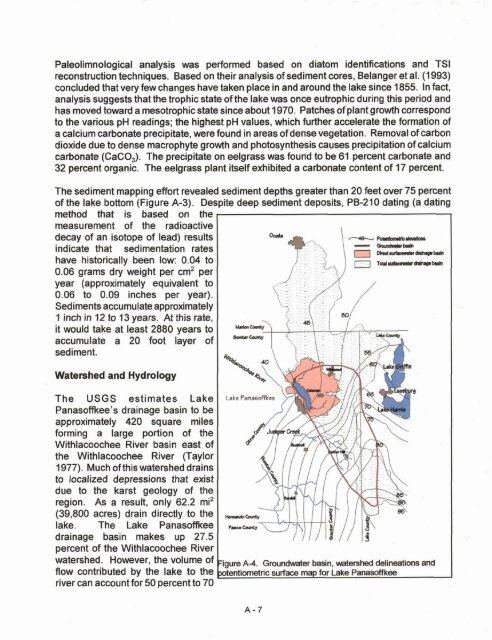
<strong>Water</strong>shed and Hydrology<br />
The USGS estimates <strong>Lake</strong><br />
<strong>Panasoffkee</strong>'s drainage basin to be<br />
approximately 420 square miles<br />
forming a large portion of the<br />
Withlacoochee River basin east of<br />
the Withlacoochee River (Taylor<br />
1977). Much of this watershed drains<br />
to localized depressions that exist<br />
due to the karst geology of the<br />
region. As a result, only 62.2 mi2<br />
(39,800 acres) drain directly to the<br />
lake. The <strong>Lake</strong> Panasoflkee<br />
drainage basin makes up 27.5<br />
percent of the Withlacoochee River<br />
watershed. However, the volume of<br />
flow contributed by the lake to the<br />
river can account for 50 percent to 70


