P-T-t trajectory of metamorphic rocks from the central ... - SciELO
P-T-t trajectory of metamorphic rocks from the central ... - SciELO
P-T-t trajectory of metamorphic rocks from the central ... - SciELO

You also want an ePaper? Increase the reach of your titles
YUMPU automatically turns print PDFs into web optimized ePapers that Google loves.
P-T-t <strong>trajectory</strong> <strong>of</strong> <strong>metamorphic</strong> <strong>rocks</strong>, Cusetpec Unit, Chiapas Massif Complex 245<br />
TMVB<br />
Mix<br />
Cha<br />
PACFIC<br />
PLATE<br />
Z<br />
Cui<br />
Tehuantepec Ridge<br />
Gulf <strong>of</strong> Mexico<br />
Maya<br />
Block<br />
Yucatán<br />
MPS<br />
NORTH AMERICAN<br />
PLATE<br />
Cayman trough<br />
Chortís<br />
Block<br />
Chicxulup<br />
impact structure<br />
Merida<br />
CARIBEAN<br />
PLATE<br />
b)<br />
N<br />
21°<br />
20°<br />
N<br />
a)<br />
COCOS<br />
PLATE<br />
200km<br />
19°<br />
Gulf <strong>of</strong> Mexico<br />
MEXICO<br />
CM<br />
Tuxtla<br />
Gutiérrez<br />
Villa Flores<br />
Villahermosa<br />
MAYA<br />
BLOCK<br />
YUCATAN<br />
GUATEMALA<br />
Belmopan<br />
Guichicovi MM<br />
Area <strong>of</strong> Figure 2<br />
(Not in scale)<br />
BELIZE<br />
MM<br />
18°<br />
17°<br />
16°<br />
Paleozoic igneous and <strong>metamorphic</strong><br />
<strong>rocks</strong> (Chiapas Massif)<br />
Paleozoic <strong>metamorphic</strong> <strong>rocks</strong><br />
(not differentiated)<br />
Paleozoic sediments<br />
(Santa Rosa group)<br />
Proterozoic (Grenville) granulites<br />
( Guichicovi complex)<br />
Major fault zones<br />
Thrust faults 100km<br />
Polochic<br />
Fault<br />
Motagua Fault<br />
Gulf <strong>of</strong><br />
Tehuantepec<br />
CHU<br />
Guatemala<br />
City<br />
HONDURAS<br />
CHORTÍS<br />
BLOCK<br />
EL SALVADOR<br />
15°<br />
14°<br />
-95°<br />
-94° -93° -92°<br />
-91° -90° -89° -88°<br />
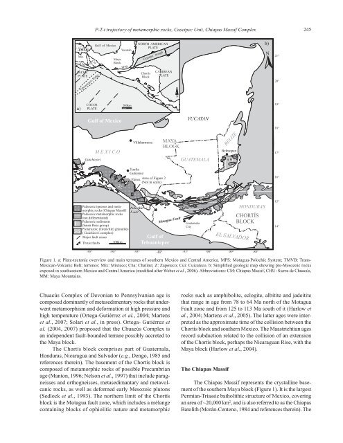
Figure 1. a: Plate-tectonic overview and main terranes <strong>of</strong> sou<strong>the</strong>rn Mexico and Central America. MPS: Motagua-Polochic System; TMVB: Trans-<br />
Mexican-Volcanic Belt; terrenos: Mix: Mixteco; Cha: Chatino; Z: Zapoteco; Cui: Cuicateco. b: Simplified geologic map showing pre-Mesozoic <strong>rocks</strong><br />
exposed in sou<strong>the</strong>astern Mexico and Central America (modified after Weber et al., 2006). Abbreviations: CM: Chiapas Massif, CHU: Sierra de Chuacús,<br />
MM: Maya Mountains.<br />
Chuacús Complex <strong>of</strong> Devonian to Pennsylvanian age is<br />
composed dominantly <strong>of</strong> metasedimentary <strong>rocks</strong> that underwent<br />
metamorphism and deformation at high pressure and<br />
high temperature (Ortega-Gutiérrez et al., 2004; Martens<br />
et al., 2007; Solari et al., in press). Ortega- Gutiérrez et<br />
al. (2004, 2007) proposed that <strong>the</strong> Chuacús Complex is<br />
an independent fault-bounded terrane possibly accreted to<br />
<strong>the</strong> Maya block.<br />
The Chortís block comprises part <strong>of</strong> Guatemala,<br />
Honduras, Nicaragua and Salvador (e.g., Dengo, 1985 and<br />
references <strong>the</strong>rein). The basement <strong>of</strong> <strong>the</strong> Chortís block is<br />
composed <strong>of</strong> <strong>metamorphic</strong> <strong>rocks</strong> <strong>of</strong> possible Precambrian<br />
age (Manton, 1996; Nelson et al., 1997) that include paragneisses<br />
and orthogneisses, metasedimantary and metavolcanic<br />
<strong>rocks</strong>, as well as deformed early Mesozoic plutons<br />
(Sedlock et al., 1993). The nor<strong>the</strong>rn limit <strong>of</strong> <strong>the</strong> Chortís<br />
block is <strong>the</strong> Motagua fault zone, which includes a mélange<br />
containing blocks <strong>of</strong> ophiolitic nature and <strong>metamorphic</strong><br />
<strong>rocks</strong> such as amphibolite, eclogite, albitite and jadeitite<br />
that range in age <strong>from</strong> 78 to 64 Ma north <strong>of</strong> <strong>the</strong> Motagua<br />
Fault zone and <strong>from</strong> 125 to 113 Ma south <strong>of</strong> it (Harlow et<br />
al., 2004; Martens et al., 2005). The latter ages were interpreted<br />
as <strong>the</strong> approximate time <strong>of</strong> <strong>the</strong> collision between <strong>the</strong><br />
Chortís block and sou<strong>the</strong>rn Mexico. The Maastrichtian ages<br />
record subduction related to <strong>the</strong> collision <strong>of</strong> an extension<br />
<strong>of</strong> <strong>the</strong> Chortís block, perhaps <strong>the</strong> Nicaraguan Rise, with <strong>the</strong><br />
Maya block (Harlow et al., 2004).<br />
The Chiapas Massif<br />
The Chiapas Massif represents <strong>the</strong> crystalline basement<br />
<strong>of</strong> <strong>the</strong> sou<strong>the</strong>rn Maya block (Figure 1). It is <strong>the</strong> largest<br />
Permian-Triassic batholithic structure <strong>of</strong> Mexico, covering<br />
an area <strong>of</strong> ~20,000 km 2 , and is also referred to as <strong>the</strong> Chiapas<br />
Batolith (Morán-Centeno, 1984 and references <strong>the</strong>rein). The