P-T-t trajectory of metamorphic rocks from the central ... - SciELO
P-T-t trajectory of metamorphic rocks from the central ... - SciELO
P-T-t trajectory of metamorphic rocks from the central ... - SciELO

You also want an ePaper? Increase the reach of your titles
YUMPU automatically turns print PDFs into web optimized ePapers that Google loves.
%<br />
%<br />
P-T-t <strong>trajectory</strong> <strong>of</strong> <strong>metamorphic</strong> <strong>rocks</strong>, Cusetpec Unit, Chiapas Massif Complex 247<br />
<strong>the</strong> Fe +2 -Mg exchange Grt-Bt <strong>the</strong>rmometer (GARB). The<br />
calibration used for <strong>the</strong> GRAIL barometer is exactly as<br />
presented in Bohlen et al. (1983) with <strong>the</strong> addition <strong>of</strong> a<br />
Ca-Mg garnet correction (following Hodges and Spear,<br />
1982). Sample JMC-01 is a garnet amphibolite suitable for<br />
<strong>the</strong> garnet + plagioclase + hornblende + quartz barometer<br />
(Kohn and Spear, 1990). Temperature estimates for this<br />
rock were calculated using <strong>the</strong> hornblende + plagioclase<br />
<strong>the</strong>rmometer <strong>of</strong> Holland and Blundy (1994).<br />
Sample preparation and wet chemical procedure for<br />
Sm-Nd isotope analysis was performed according to Weber<br />
and López-Martínez (2006). About ~200 mg <strong>of</strong> garnet was<br />
separated <strong>from</strong> a garnet-amphibolite (CB45). The dissolved<br />
garnet sample was split into two aliquots (1/3 and 2/3). The<br />
smaller (1/3) aliquot was spiked for isotope dilution analysis<br />
(ID-run) for both Sm and Nd; <strong>the</strong> larger aliquot was used<br />
for <strong>the</strong> Nd isotope composition run, to achieve precise<br />
isotopic ratios. Sm and Nd isotopic ratios were measured<br />
in static mode on a Finnigan MAT 262 mass spectrometer<br />
at <strong>the</strong> Laboratorio Universitario de Geoquímica Isotópica<br />
at Universidad Autónoma de Mexico. Sm and Nd isotopic<br />
ratios were corrected for mass fractionation by normalizing<br />
to 152 Sm/ 147 Sm = 1.78308 and 146 Nd/ 144 Nd = 0.7219.<br />
GEOLOGY AND PETROGRAPHY OF THE<br />
CUSTEPEC UNIT<br />
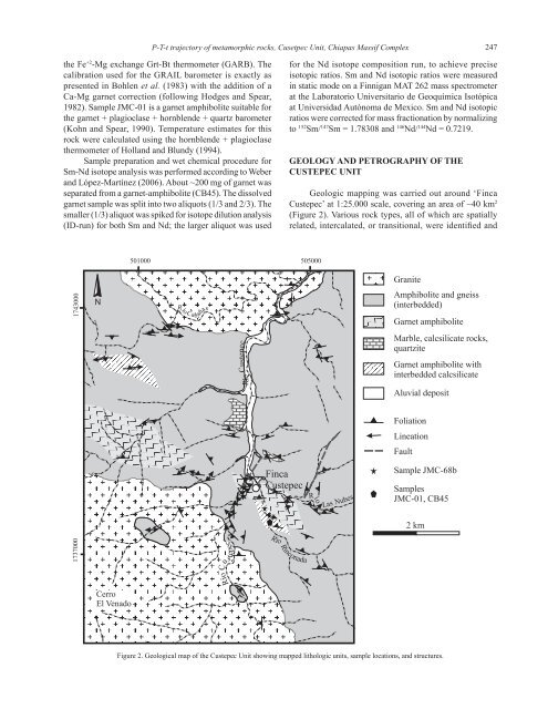
Geologic mapping was carried out around ‘Finca<br />
Custepec’ at 1:25.000 scale, covering an area <strong>of</strong> ~40 km 2<br />
(Figure 2). Various rock types, all <strong>of</strong> which are spatially<br />
related, intercalated, or transitional, were identified and<br />
501000 505000<br />
Granite<br />
1743000<br />
N<br />
Río Cab<br />
aña<br />
s<br />
Amphibolite and gneiss<br />
(interbedded)<br />
Garnet amphibolite<br />
Río Custepec<br />
Marble, calcsilicate <strong>rocks</strong>,<br />
quartzite<br />
Garnet amphibolite with<br />
interbedded calcsilicate<br />
Aluvial deposit<br />
Foliation<br />
Lineation<br />
Fault<br />
Finca<br />
Custepec<br />
Río<br />
N<br />
Las u<br />
bes<br />
Sample JMC-68b<br />
Samples<br />
JMC-01, CB45<br />
2km<br />
1737000<br />
pec<br />
Río C<br />
e<br />
t<br />
us<br />
R<br />
íoRinc<br />
o<br />
nada<br />
Cerro<br />
El Venado<br />
Figure 2. Geological map <strong>of</strong> <strong>the</strong> Custepec Unit showing mapped lithologic units, sample locations, and structures.