St Arnaud - Tasman District Council
St Arnaud - Tasman District Council
St Arnaud - Tasman District Council

You also want an ePaper? Increase the reach of your titles
YUMPU automatically turns print PDFs into web optimized ePapers that Google loves.
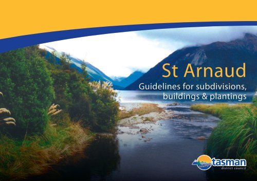
<strong>St</strong> <strong>Arnaud</strong><br />
Guidelines for subdivisions,<br />
buildings & plantings
Contents<br />
1. Introduction .................................................................................................... 1<br />
2. Aim .................................................................................................................. 1<br />
3. <strong>St</strong> <strong>Arnaud</strong> Landscape Priority Area (Map) .................................................... 1<br />
4. Visual Character of <strong>St</strong> <strong>Arnaud</strong> ....................................................................... 2<br />
5. Guidelines ...................................................................................................... 3<br />
5.1 Subdivisions ......................................................................................... 3<br />
5.2 Roads, Accessways and Driveways...................................................... 3<br />
5.3 Siting of Buildings ................................................................................. 4<br />
5.4 Building Form, Design and Colour ........................................................ 4<br />
5.5 Fences, Gates and Signage ................................................................. 5<br />
5.6 Wildlife Corridors .................................................................................. 5<br />
5.7 Amenity Planting ................................................................................... 5<br />
5.8 Weed Control ........................................................................................ 6
1. Introduction<br />
<strong>St</strong> <strong>Arnaud</strong> is located at the northern end of Lake Rotoiti. It has a very strong relationship with the Nelson<br />
Lakes National Park, being almost surrounded by it. Portions of the town’s western and eastern<br />
boundaries and all of its southern boundaries abut the Park. To the north of the town is Big Bush <strong>St</strong>ate<br />
Forest.<br />
It is the gateway to the National Park and it is visible from many parts of the Park. Its unique character<br />
has resulted in <strong>St</strong> <strong>Arnaud</strong> being identified in the <strong>Tasman</strong> Resource Management Plan (TRMP) as a<br />
“Landscape Priority Area”.<br />
To protect these characteristics, new buildings or major extensions to existing buildings within the<br />
“Landscape Priority Area” require resource consent. See chapter 18.2 of the TRMP.<br />
In a resource consent application for a building the <strong>Council</strong> will consider matters including:<br />
●<br />
●<br />
The effects of the location, design and appearance of the building, including scale, materials,<br />
colour and landscaping.<br />
The effects on natural features and the indigenous vegetation.<br />
2. Aim<br />
The aim of this booklet is to provide guidelines and advice to ensure any new developments in the<br />
<strong>St</strong> <strong>Arnaud</strong> area (buildings, roads, subdivisions) are designed to blend in with the unique natural qualities<br />
and landscape values of the area.<br />
3. <strong>St</strong> <strong>Arnaud</strong> Landscape Priority Area (Map)<br />
1
4. Visual Character of <strong>St</strong> <strong>Arnaud</strong><br />
The landscape character of an area is the visual expression of the main elements that make up the picture -<br />
the line, form, colour, texture and pattern. It is determined by those elements that, through repetition,<br />
combine to give a place its distinctive identity. For <strong>St</strong> <strong>Arnaud</strong> this includes:<br />
The landforms. <strong>St</strong> <strong>Arnaud</strong> is located at the base of a valley on the shores of Lake Rotoiti and is<br />
dominated by the surrounding landforms of the <strong>St</strong> <strong>Arnaud</strong> Range, Big Bush Forest and Black Hill. <strong>St</strong>ate<br />
Highway 63 and the commercial centre are visually separated from the lake and some of the residential<br />
development by a vegetated moraine ridge. This means that the views from <strong>St</strong> <strong>Arnaud</strong> are generally<br />
outward and upward towards the mountains.<br />
The vegetation in the area is dominated by the dark green colour of the beech forests and the olive green<br />
of the regenerating kanuka/manuka forest which are in stark contrast to the lighter grazed grass of the<br />
valley floor. Deciduous trees can be found within the commercial area along <strong>St</strong>ate Highway 63, and<br />
following the Black Valley stream.<br />
Ecological Areas. The Landscape Priority Area can be divided up into five distinct zones each with its<br />
own pattern of vegetation. Broadly, these are:<br />
Mature beech forest found generally on the slopes above <strong>St</strong> <strong>Arnaud</strong> and within the national park.<br />
Manuka/kanuka bush and regenerating beech forest found within the older parts of the village<br />
adjacent to the park, the lake and increasingly along the Black Valley <strong>St</strong>ream.<br />
Wetland vegetation found within the village as well as to the northwest and east of the village<br />
centre.<br />
The flat areas around the village comprising some communities of indigenous bush intermingled<br />
with exotic trees around the commercial centre and along the lower sections of the Black Valley<br />
stream.<br />
Areas of modified pasture, which mostly occupy the valley as one travels east along SH63 to<br />
Tophouse.<br />
Roading has a significant impact on the character of the area. While the houses in <strong>St</strong> <strong>Arnaud</strong> are<br />
generally screened from view and set within planted sections, the roads form the visible element. The<br />
informality of the roading, often without footpaths and formal kerb and channel, establishes a character<br />
that is valued by residents. While there are instances where, in the interests of safety, lighting is a<br />
requirement, generally the lack of streetlights is a quality that is valued because it enhances the visibility<br />
of the night sky.<br />
An extensive walkway system exists independent of the roading network, and where walkways do<br />
coincide with roads, a degree of separation and independence is maintained between the footpath and the<br />
road.<br />
Drainage systems are required to manage stormwater run-off, which runs into the Black Valley <strong>St</strong>ream<br />
and the lake. To avoid the use of kerb and channel, stabilised swales have been successfully used as a<br />
“soft” engineering solution. The <strong>St</strong> <strong>Arnaud</strong> Landscape Priority Area falls within the immediate water<br />
catchment area of Lake Rotoiti. The cleanliness of the lake is dependent on the preservation and<br />
maintenance of the natural filtration systems. Extreme care needs to be taken to retain the existing<br />
vegetation near the watercourses in the area.<br />
Buildings. Older established housing around the lake is generally set in amongst vegetation and is well<br />
screened from the road. The majority are simple baches, with timber the predominant wall cladding. They<br />
have a low impact on the area because of their scale and the abundant planting.<br />
Housing along the main road and in new subdivisions has a greater impact. The new subdivisions are<br />
particularly exposed as planting is only just being established.<br />
Commercial buildings such as the Alpine Lodge and National Park Headquarters reflect a New Zealand<br />
architectural style, which fits well into the natural landscape. They are set back from the road and are well<br />
landscaped.<br />
At first glance, many boundaries of properties are invisible because houses are separated by vegetation.<br />
2
5. Guidelines<br />
The distinctive character of the area is extremely sensitive to<br />
change. Buildings should be carefully located and designed to<br />
ensure they harmonise and are sympathetic with the landscape,<br />
rather than intruding into it.<br />
Avoid creating an arbitrary grid with new<br />
subdivisions<br />
Property boundaries should follow<br />
existing landscape patterns and contours,<br />
and preserve natural features<br />
5.1 Subdivisions<br />
Property boundaries should be located in response to<br />
existing natural features of the landscape, such as vegetation<br />
patterns, valleys, contours and streams, rather than form an<br />
arbitrary grid.<br />
Landscape features such as wetlands, prominent trees, or<br />
rock outcrops should be recognised, protected, and<br />
integrated into the subdivision layout.<br />
Indigenous vegetation cover, including established and<br />
regenerating forest, should be retained and protected.<br />
Opportunities to extend existing walkways and incorporate<br />
natural features into the subdivision design as reserves or<br />
covenants should be considered.<br />
Preference should be given to retaining and enhancing<br />
existing streams and drainage lines as landscape features<br />
rather than piping them.<br />
Pedestrian paths should be separated from<br />
the road and respond to local vegetation,<br />
rock features and landforms<br />
The existing informality should be<br />
retained. Where possible, kerb and<br />
channel should be avoided.<br />
5.2 Roads, Accessways and Driveways<br />
Roads, accessways and driveways should recognise and<br />
acknowledge natural features and reflect the dominant lines<br />
in the landscape context. Footpaths need to tie into and<br />
develop the existing pedestrian network.<br />
Where space permits, pedestrian paths should be located<br />
independent of roads to retain the informality of the existing<br />
road network. When adjacent to roads, the footpath can still<br />
incorporate localised vegetation, rock features and<br />
landforms.<br />
Kerb and channel edging to roads should be avoided if at all<br />
possible. <strong>St</strong>abilised swales, small wetlands and ponds,<br />
should be used to accommodate and filter stormwater runoff<br />
from the roads.<br />
<strong>St</strong>reet lighting should be low key and sensitively positioned.<br />
Upward light spill should be minimised. Aim to develop a<br />
standard style of lighting throughout <strong>St</strong> <strong>Arnaud</strong>.<br />
3
Set buildings back from the road and use<br />
appropriate planting to screen buildings<br />
from the road<br />
5.3 Siting of Buildings<br />
The location and siting of buildings can have a major visual<br />
impact.<br />
Set buildings back from the road and use planting to screen<br />
buildings from the road.<br />
A resource consent is needed for the clearance of indigenous<br />
forest other than to form a building site and access. Every<br />
effort should be made to retain and protect all native plants<br />
growing naturally around the building site.<br />
Buildings should be nestled on the edges of landforms and<br />
vegetation patterns to take advantage of shelter and help<br />
them to blend into the landscape.<br />
Earthworks for building sites and accessways should be<br />
finished to a natural contour, blended to adjacent slopes and<br />
revegetated with woody or herbaceous plants as appropriate<br />
for the context.<br />
Rooflines should reflect background<br />
landforms<br />
Avoid pole houses and excessively elevated<br />
structures. Buildings should blend with<br />
the contours<br />
5.4 Building Form, Design and Colour<br />
Generally, build to the contours. The building form should<br />
reflect the contours of the site, avoiding the need for<br />
substantial pole supports or large basements.<br />
Building design should incorporate typical New Zealand<br />
architectural styles and avoid those styles typically<br />
associated with other cultures. The Alpine Lodge and Park<br />
Headquarters are good examples.<br />
Rooflines should reflect background landforms. On elevated<br />
sites, roof slopes should follow the natural slope of the land.<br />
Satellite dishes and antennae should be sited and mounted<br />
so they are visually unobtrusive.<br />
Materials should respond to and link with the surrounding<br />
landscape. Materials such as stone, timber and corrugated<br />
iron are appropriate.<br />
Every effort should be made to ensure that rooflines do not<br />
project above the crest of the ridge or backdrop vegetation.<br />
In general, roofs should be darker than walls. Colours<br />
should be based on background colours and be low in<br />
reflectivity (less than 30%). Small areas of brighter accent<br />
colours can be used to contrast positively with the dominant<br />
background colour.<br />
4
Formal gateways onto individual<br />
properties are discouraged. Gates should<br />
be set back from the road to reduce<br />
visibility.<br />
5.5 Fences, Gates and Signage<br />
The boundaries of properties are generally defined and privacy<br />
provided through the use of vegetation.<br />
Formal fencing styles should be avoided. Where fencing is<br />
deemed necessary, keep it low and consider using materials<br />
such as post and wire or natural materials such as stone<br />
suited to the location.<br />
Formal gateways onto individual properties are discouraged.<br />
Signs identifying ownership of residential properties should<br />
be subtle and low key.<br />
5.6 Wildlife Corridors<br />
The village occupies the site where the Nelson Lakes National<br />
Park and Big Bush <strong>St</strong>ate Forest Park are geographically at their<br />
closest. Vegetation communities play a vital role in allowing<br />
movement of fauna between these two larger vegetation<br />
communities.<br />
Preserve all existing indigenous communities, including<br />
young regenerating bush.<br />
Enhance and expand these communities through<br />
supplementary planting of appropriate indigenous species<br />
(See “Native Plantings Guide for Buildings and Gardens in<br />
<strong>St</strong> <strong>Arnaud</strong>”)<br />
The boundaries of properties are generally<br />
defined using vegetation<br />
5.7 Amenity Planting<br />
Use native species that are characteristic of your particular<br />
site. The use of locally sourced plant material is encouraged<br />
to protect the genetic integrity of the local vegetation. (The<br />
aim is to preserve the natural character of the <strong>St</strong> <strong>Arnaud</strong><br />
area. It is encouraged that only species suited to the various<br />
conditions around the village be used. To assist with this,<br />
“Native Plantings Guide for Buildings and Gardens in <strong>St</strong><br />
<strong>Arnaud</strong>”, which is available from the TDC, identifies<br />
specific plants that are suited to the specific area within the<br />
village.)<br />
Collaborate with neighbours to create larger vegetated areas<br />
that could accommodate taller tree species such as<br />
manuka/kanuka and beech.<br />
Protect existing stands of young and mature indigenous<br />
vegetation.<br />
Use vegetation to screen and separate buildings in<br />
preference to fences and walls.<br />
Screen the buildings from the road using indigenous<br />
vegetation that is compatible with other indigenous planting<br />
along the road in order to create a cohesive vegetated<br />
streetscape.<br />
Use species that will attract local indigenous wildlife.<br />
Use an informal design for the landscape and avoid planting<br />
in straight lines.<br />
5
Russell Lupin<br />
Rowan<br />
Gorse<br />
5.8 Weed Control<br />
A number of weeds are threatening the natural forest and wetland<br />
vegetation of <strong>St</strong> <strong>Arnaud</strong>, and other weeds are likely to reach the<br />
settlement in due course. It is easier to prevent weeds establishing<br />
when there are only a few of them than try to remove them once<br />
they are widespread. The co-operation of all residents is needed to<br />
remove all known and potential weeds wherever they are found,<br />
and to make sure that none are deliberately introduced.<br />
<strong>Tasman</strong> <strong>District</strong> <strong>Council</strong>'s “Regional Pest Management <strong>St</strong>rategy”<br />
identifies plants and pests problematical to this area. This booklet<br />
and further information prepared by DOC outlines those species<br />
that have the potential to be a problem in this area. These include:<br />
Douglas Fir<br />
Rowan or Mountain Ash,<br />
Cotoneaster<br />
Buddleia<br />
Blackberry<br />
Russell Lupin<br />
Broom and Gorse<br />
Darwin’s Barberry<br />
Japanese Honeysuckle<br />
Mexican Daisy<br />
Holly<br />
Hieracium Daisy<br />
6
Reference Books<br />
Native Planting Guide for Buildings & Gardens in <strong>St</strong> <strong>Arnaud</strong>, available from TDC offices.<br />
<strong>Tasman</strong> Nelson Regional Pest Management <strong>St</strong>rategy 2007, available from TDC offices.<br />
Cartman J (1985), Growing New Zealand Alpine Plants, Reed Methuen Publishers Ltd, Auckland.<br />
Mark A.F & Adams N.M. (1986), New Zealand Alpine Plants, Reed Methuen Publishers Ltd,<br />
Auckland.<br />
Porteous T. (1993), Native Forest Restoration: A Practical Guide for Landowners”, Queen<br />
Elizabeth the Second National Trust.<br />
Weedbusters (2007), Plant Me Instead, Nelson/Marlborough Edition<br />
Further Assistance<br />
Specific advice for your site can be obtained by contacting Architects or Landscape Architects,<br />
listed in the Yellow Pages.<br />
Information regarding the <strong>Tasman</strong> Resource Management Plan can be obtained from the <strong>Tasman</strong><br />
<strong>District</strong> <strong>Council</strong>.<br />
For advice on weeds, contact Department of Conservation, Nelson Lakes Area Office<br />
Prepared for <strong>Tasman</strong> <strong>District</strong> <strong>Council</strong> by:<br />
Arthouse Architecture – David Wallace B Arch, FNZIA<br />
Rory Langbridge, Landscape Architect, B Sc BLA (Hons) ANZILA<br />
7