Landscape Guide - Takaka Hill - Tasman District Council
Landscape Guide - Takaka Hill - Tasman District Council
Landscape Guide - Takaka Hill - Tasman District Council

You also want an ePaper? Increase the reach of your titles
YUMPU automatically turns print PDFs into web optimized ePapers that Google loves.
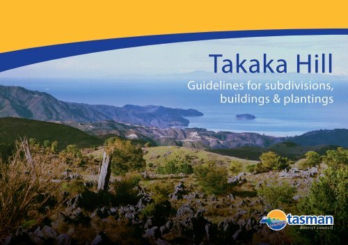
<strong>Takaka</strong> <strong>Hill</strong><br />
<strong>Guide</strong>lines for subdivisions,<br />
buildings & plantings
Contents<br />
1. Introduction ..................................................................................................... 1<br />
2. Aim ................................................................................................................... 1<br />
3. <strong>Takaka</strong> <strong>Hill</strong> <strong>Landscape</strong> Priority Area .............................................................. 1<br />
4. Visual Character of the <strong>Takaka</strong> <strong>Hill</strong> ................................................................ 2<br />
5.1 Subdivisions ........................................................................................... 3<br />
5.2 Roads, Accessways and Driveways ....................................................... 3<br />
5.3 Siting of Buildings................................................................................... 4<br />
5.4 Building Form and Colour ....................................................................... 4<br />
5.5 Other Structures, Fences, Gates and Signage ....................................... 5<br />
5.6 Utility Services ....................................................................................... 5<br />
5.7 Wildlife Corridors .................................................................................... 5<br />
5.8 Amenity Planting .................................................................................... 6<br />
5.9 Weed Control ......................................................................................... 6<br />
5.10 Plantations ............................................................................................. 6
1. Introduction<br />
<strong>Takaka</strong> <strong>Hill</strong> is renowned for its outstanding landscape quality and views. This karst landscape lies between the<br />
Pikikiruna Range to the north and the Arthur Range to the south, separating <strong>Tasman</strong> Bay and Golden Bay.<br />
The topography, climate, vegetation patterns and panoramic views as well as the strategic location between two<br />
national parks contribute to the unique character of the <strong>Takaka</strong> <strong>Hill</strong>. These unique qualities have resulted in the<br />
<strong>Takaka</strong> <strong>Hill</strong> being identified in the <strong>Tasman</strong> Resource Management Plan (TRMP) as a “<strong>Landscape</strong> Priority<br />
Area”.<br />
To protect these characteristics, new buildings or major extensions to existing buildings within the “<strong>Landscape</strong><br />
Priority Area” require resource consent, as will new forestry proposals. (See Chapter 18.2 of the TRMP)<br />
In a resource consent application for a building, the <strong>Council</strong> will consider matters including:<br />
The effects of the location, design and appearance of the building, including scale, materials, colour and<br />
landscaping.<br />
The effects on natural features and the indigenous vegetation.<br />
In a resource consent application for a plantation forest, the <strong>Council</strong> will consider matters including:<br />
The scale and shape of the forest, planting pattern and compatibility with the topography of the site.<br />
The effect on the view from public roads and open spaces.<br />
Planting and retention of indigenous vegetation to ameliorate future harvesting effects and maintain the<br />
integrity of the waterways.<br />
2. Aim<br />
The aim of this booklet is to provide guidelines and advice to ensure any new developments in the <strong>Takaka</strong> <strong>Hill</strong><br />
area (buildings, roads, plantations) are designed to maintain and protect the unique natural qualities and<br />
landscape values of the area.<br />
3. <strong>Takaka</strong> <strong>Hill</strong> <strong>Landscape</strong> Priority Area<br />
1
4. Visual Character of the <strong>Takaka</strong> <strong>Hill</strong><br />
The landscape character of an area is the visual expression of the main elements that make up the picture – the<br />
line, form, colour, texture, and pattern. It is determined by those elements that, through repetition, combine to<br />
give a place its distinctive identity. For the <strong>Takaka</strong> <strong>Hill</strong> this includes:<br />
The landforms of the <strong>Takaka</strong> <strong>Hill</strong> are a range of highly visible and distinctive features, including bluffs, rock<br />
outcrops, sinkholes, ridgelines and skylines. The surface karst features predominate throughout the native scrub<br />
and pastoral areas of the <strong>Hill</strong>. They are obscured from view where native bush remnants remain or where<br />
forestry activities predominate. There are panoramic views to be had over much of the southern section and<br />
beyond to <strong>Tasman</strong> and Golden Bays.<br />
The vegetation in the area contributes to an evergreen landscape. Pastoral farming patterns are mixed with<br />
areas of remnant forests, scrub and plantation forestry. The proximity of the area to Abel <strong>Tasman</strong> and Kahurangi<br />
national parks makes the retention and protection of existing and regenerating indigenous forests important to<br />
provide habitat and ecological corridors.<br />
Buildings are made visible by their form, location and colour in the landscape. There is a low density of<br />
building development on the <strong>Takaka</strong> <strong>Hill</strong>. The majority of the houses are sited discreetly and are not noticeable<br />
from the road. Buildings located close to the road in highly visible locations cause the greatest impact on the<br />
landscape.<br />
The roads, State Highway 60 and Canaan Road, are the means of transport and access to the area‟s unique<br />
features and provide the main viewing platform for the area. While there are two viewing lay-bys on SH60, at<br />
Ngarua Caves and Bobs Lookout, expansive views are enjoyed from all along these roads. Walkways have been<br />
developed, such as the <strong>Takaka</strong> <strong>Hill</strong> and the Hawkes Lookout tracks, which encourage greater exploration of the<br />
area.<br />
The visual sensitivity of the karst landscape and visual prominence of much of the area result in a landscape<br />
that has a low capacity to absorb change and a character which is particularly sensitive to alteration to land use,<br />
land cover and land form.<br />
2
Subdivision boundaries to follow natural<br />
patterns and respect natural features<br />
5. <strong>Guide</strong>lines<br />
5.1 Subdivisions<br />
For subdivisions on <strong>Takaka</strong> <strong>Hill</strong>, consideration needs to be given to the<br />
pattern and scale of subdivision, the plantings, the road layout, and the<br />
nature and extent of earthworks. To ensure they are consistent with the<br />
character of the landscape:<br />
Property boundaries should be located in response to existing natural<br />
features of the landscape such as vegetation patterns, valleys,<br />
contours and streams, rather than form an arbitrary grid.<br />
Allotment size. The existing minimum section size of 50 hectares<br />
generally maintains the low density of houses when seen from any<br />
particular viewing location. The topography and vegetation patterns<br />
dictate the absorption capacity of an area with the exposed karst<br />
topography being particularly sensitive to change.<br />
<strong>Landscape</strong> features such as wetlands, prominent trees, or rock<br />
outcrops should be recognised, protected, and integrated into the<br />
subdivision layout.<br />
Indigenous vegetation cover, both established and regenerating<br />
forest, should be retained and protected. Where areas are grazed by<br />
stock, bush remnants need to be fenced to avoid browsing of the<br />
understorey.<br />
Consider opportunities to extend existing walkways and incorporate<br />
natural features into the subdivision design as reserves or covenants.<br />
Use roading that follows the contours<br />
and preserves natural features<br />
5.2 Roads, Accessways and Driveways<br />
Roads, accessways and driveways should recognise and<br />
acknowledge natural features and reflect the dominant lines in the<br />
landscape context. Locate where possible on the edges of landform<br />
and vegetation patterns.<br />
To reduce visual exposure and the potential to cause erosion, roads<br />
and accessways should follow the existing contours and avoid steep<br />
zigzags across exposed faces.<br />
Avoid excessive excavation for roading. Special care needs to be<br />
taken to avoid damage to the existing rock formations.<br />
Avoid zigzags across exposed faces<br />
3
Buildings should be sited to allow<br />
appropriate access to be achieved<br />
5.3 Siting of Buildings<br />
The location and siting of buildings can have a major visual impact.<br />
New buildings should be sited so that they are not highly visible<br />
from public roads.<br />
Ensure that building sites are located so that road access can be<br />
provided to them in an alignment and grade that is appropriate.<br />
Buildings should be nestled on the edges of landforms and vegetation<br />
patterns to take advantage of shelter and help them to blend into the<br />
landscape.<br />
Earthworks for building sites and accessways should be finished to a<br />
natural contour, blended to adjacent slopes and revegetated with<br />
woody or herbaceous plants as appropriate for the context.<br />
To protect neighbour‟s privacy and views avoid siting new buildings<br />
within close proximity to or in view of neighbours.<br />
Straight driveways are visually prominent<br />
and susceptible to increased erosion<br />
Cluster buildings together and provide<br />
unity in form to reduce visual impact<br />
5.4 Building Form and Colour<br />
The intention of the guidelines is not to limit the designer‟s creativity but<br />
to encourage sympathetic design in response to this landscape.<br />
Cluster buildings together on a site and provide a unity in colour and<br />
design to reduce the impact of new development.<br />
The shape of structures should generally reflect background<br />
landforms. Avoid large unrelieved expanses of roofs and walls.<br />
Materials for buildings should respond to and link with the<br />
surrounding landscape.<br />
Every effort should be made to ensure that rooflines do not project<br />
above the crest of the ridge or backdrop vegetation.<br />
In general, roofs should be darker than walls. Colours should be<br />
based on background colours and be low in reflectivity (less than<br />
30%). Small areas of brighter accent colours can be used to contrast<br />
positively with the dominant background colour.<br />
4
Gates and signage should be low key<br />
using local materials to preserve rural<br />
character<br />
5.5 Other Structures, Fences, Gates and<br />
Signage<br />
Structures such as yards, retaining walls and bridges should be of<br />
natural materials.<br />
Avoid high profile gates. Gates, if required, should be rural in<br />
character, using local material.<br />
Outdoor lighting should be low-level and focused downwards to<br />
minimise light spill that affects the night sky.<br />
Generally, signage should be unlit and low-level using natural<br />
materials. Colours used should be based on background colours and<br />
be low in reflectivity (less than 30%). Small areas of brighter accent<br />
colours can be used to contrast positively with the dominant<br />
background colour.<br />
Gates, if required, should be rural in<br />
character<br />
Avoid exposed ridges and locate where<br />
buildings can be screened<br />
5.6 Utility Services<br />
Utility services such as overhead wires and transmitter towers can have a<br />
major impact on the area.<br />
Locate utilities in discreet positions and avoid exposed ridgelines and<br />
view corridors. Where possible, locate towers where ancillary<br />
buildings can be effectively screened.<br />
Excavation should be minimised. Special care needs to be taken to<br />
avoid damage to the existing rock formations.<br />
<strong>Landscape</strong> features such as wetlands, watercourses, ridgelines or<br />
prominent rock outcrops should be avoided.<br />
Locate utilities in discrete positions<br />
5.7 Wildlife Corridors<br />
The proximity of the area to two national parks makes the<br />
accommodation of wildlife in the area critical.<br />
Where possible, protect all areas of existing and regenerating native<br />
forest by fencing out grazing animals.<br />
Consider species that will attract local indigenous wildlife. Link<br />
isolated indigenous forest islands with each other as well as with the<br />
larger indigenous forests.<br />
5
5.8 Amenity Planting<br />
The planting around buildings requires a simple „broadbrush‟<br />
approach suitable to a rural location rather than the more ornamental<br />
styles found in urban settings.<br />
Large groups of one or two species should be used. Choose species<br />
that reflect the surrounding countryside.<br />
Avoid coloured cultivars such as golden totara, yellow cypress and<br />
deciduous species with bright autumn colour, as these types will<br />
stand out in the predominantly green/brown landscape of the <strong>Takaka</strong><br />
<strong>Hill</strong>.<br />
Avoid an urban planting scheme.<br />
Use species that reflect the<br />
surrounding countryside<br />
5.9 Weed Control<br />
As weed control is expensive and labour intensive, effective<br />
management of weeds in an area should focus on the prevention of<br />
weeds becoming established. The co-operation of all residents is<br />
needed to remove all known and potential weeds wherever they are<br />
found, and to make sure that none are deliberately introduced.<br />
<strong>Tasman</strong> <strong>District</strong> <strong>Council</strong>'s Regional Pest Management Strategy 2007,<br />
identifies plants and pests problematical to this area. This booklet<br />
and further information is available from the <strong>Council</strong>. Species<br />
identified as being problematical include Pampas Grass, Buddleia,<br />
Old Man‟s Beard, Passion Vine, Madeira Vine, Cotoneaster and<br />
Wild Ginger.<br />
Avoid plantings that create silhouettes<br />
Shape of woodlots to reflect<br />
existing contours<br />
5.10 Plantations<br />
The <strong>Takaka</strong> <strong>Hill</strong> landscape is vulnerable to change. Plantation forestry<br />
can have a dramatic impact on a landscape. Some general guidelines to<br />
follow are:<br />
Selection of Species<br />
Species grown in prominent locations should be evergreen conifer<br />
species. Trees with prominent spring or autumn colour should be<br />
avoided.<br />
Note: Douglas Fir should be discouraged from being grown<br />
adjacent to national parks due to its ability to invade the indigenous<br />
forests.<br />
Shaping<br />
The shape of woodlots should reflect existing landforms and avoid<br />
the imposition of arbitrary geometric shapes onto slopes.<br />
Avoid planting that silhouettes single specimens or edges of<br />
plantations against the skyline.<br />
Plant trees along the contour line rather than in straight lines running<br />
vertically up and down the slopes.<br />
Where possible locate new plantations adjacent to existing ones to<br />
avoid a fragmented pattern developing in the landscape.<br />
6
Reference Books<br />
<strong>Tasman</strong> Nelson Regional Pest Management Strategy 2007, available from TDC offices.<br />
Cartman J (1985) Growing New Zealand alpine plants, Reed Methuen Publishers Ltd, Auckland.<br />
Mark A F & Adams N M (1986) New Zealand alpine plants, Reed Methuen Publishers Ltd,<br />
Auckland.<br />
Porteous T. (1993) Native forest restoration: A practical guide for landowners, Queen Elizabeth the<br />
Second National Trust.<br />
Further Assistance<br />
Specific advice for your site can be obtained by contacting architects or landscape architects, listed in<br />
the Yellow Pages.<br />
Information regarding the Resource Management Plan can be obtained from the <strong>Tasman</strong> <strong>District</strong><br />
<strong>Council</strong>.<br />
Prepared for <strong>Tasman</strong> <strong>District</strong> <strong>Council</strong> by:<br />
Arthouse Architecture – David Wallace B Arch, FNZIA<br />
Rory Langbridge, <strong>Landscape</strong> Architect, B Sc BLA (Hons) ANZILA<br />
7