Geotechnical Assessment - Taupo District Council
Geotechnical Assessment - Taupo District Council
Geotechnical Assessment - Taupo District Council

Create successful ePaper yourself
Turn your PDF publications into a flip-book with our unique Google optimized e-Paper software.
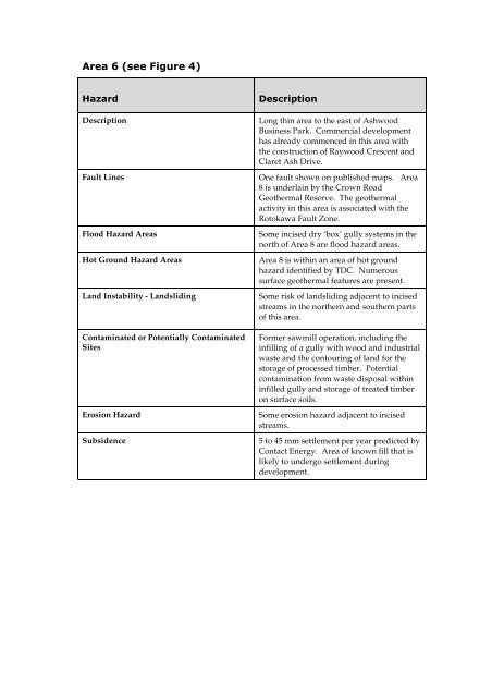
Description<br />
Fault Lines<br />
Flood Hazard Areas<br />
Hot Ground Hazard Areas<br />
Land Instability - Landsliding<br />
Contaminated or Potentially Contaminated<br />
Sites<br />
Erosion Hazard<br />
Subsidence<br />
<br />
Long thin area to the east of Ashwood<br />
Business Park. Commercial development<br />
has already commenced in this area with<br />
the construction of Raywood Crescent and<br />
Claret Ash Drive.<br />
One fault shown on published maps. Area<br />
8 is underlain by the Crown Road<br />
Geothermal Reserve. The geothermal<br />
activity in this area is associated with the<br />
Rotokawa Fault Zone.<br />
Some incised dry ‘box’ gully systems in the<br />
north of Area 8 are flood hazard areas.<br />
Area 8 is within an area of hot ground<br />
hazard identified by TDC. Numerous<br />
surface geothermal features are present.<br />
Some risk of landsliding adjacent to incised<br />
streams in the northern and southern parts<br />
of this area.<br />
Former sawmill operation, including the<br />
infilling of a gully with wood and industrial<br />
waste and the contouring of land for the<br />
storage of processed timber. Potential<br />
contamination from waste disposal within<br />
infilled gully and storage of treated timber<br />
on surface soils.<br />
Some erosion hazard adjacent to incised<br />
streams.<br />
5 to 45 mm settlement per year predicted by<br />
Contact Energy. Area of known fill that is<br />
likely to undergo settlement during<br />
development.