Geotechnical Assessment - Taupo District Council
Geotechnical Assessment - Taupo District Council
Geotechnical Assessment - Taupo District Council

Create successful ePaper yourself
Turn your PDF publications into a flip-book with our unique Google optimized e-Paper software.
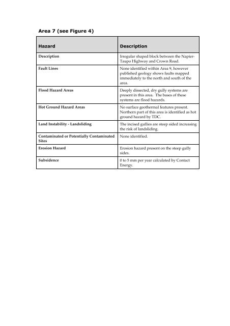
Description<br />
Fault Lines<br />
Flood Hazard Areas<br />
Hot Ground Hazard Areas<br />
Land Instability - Landsliding<br />
Contaminated or Potentially Contaminated<br />
Sites<br />
Erosion Hazard<br />
Subsidence<br />
<br />
Irregular shaped block between the Napier-<br />
<strong>Taupo</strong> Highway and Crown Road.<br />
None identified within Area 9, however<br />
published geology shows faults mapped<br />
immediately to the north and south of the<br />
area.<br />
Deeply dissected, dry gully systems are<br />
present in this area. The bases of these<br />
systems are flood hazards.<br />
No surface geothermal features present.<br />
Northern part of this area is identified as hot<br />
ground hazard by TDC.<br />
The incised gullies are steep sided increasing<br />
the risk of landsliding.<br />
None identified.<br />
Erosion hazard present on the steep gully<br />
sides.<br />
0 to 5 mm per year calculated by Contact<br />
Energy.