021 (Winter 1973) - National Speleological Society
021 (Winter 1973) - National Speleological Society
021 (Winter 1973) - National Speleological Society

You also want an ePaper? Increase the reach of your titles
YUMPU automatically turns print PDFs into web optimized ePapers that Google loves.
The Journal of Spelean History <br />
OFFICI PUBUCATION of The AMERICAN SPELEAN HISTORY ASSOCIATION<br />
..<br />
*\ vlinter <strong>1973</strong><br />
Volume 6, No. 1 ·
ABOUT THE ASSOCIATION<br />
The American Spelean History Association is chartered as a non-profit<br />
corporation for the study, dissemination and int erpretation of spelean<br />
history and related purposes. All persons of hi gh ethical and moral<br />
character who are interested in these goals are cordially invited to become<br />
members. Annual membership is $5.00; family membership<br />
$6.00. Library subscriptions are $4.00.<br />
ABOUT THE QUARTERLY<br />
The Association publishes the Journal of Spelean History on a quarterly<br />
basis.<br />
P ertinent articles or reprints are welcomed. A s a photo -offset<br />
process is often used, the editor should be contacted in advance concerning<br />
the current type of manuscript preparation desired. Submission of<br />
rough drafts for preliminary editing is encouraged. lllustrations require<br />
special handling and arrangements must be made with the editor<br />
in advance.<br />
ABOUT BACK ISSUES<br />
The last two volues are available from the Secretary-treasurer at $5.00<br />
per volume. About half the other issues are available at $1. 00 per copy.<br />
All back issues are available on microfiche; for further information<br />
contact 3M-International Microfilm Press, 52.1 West 43rd Street, New<br />
York, N.Y. 10036.<br />
C)<br />
ABOUT<br />
THE<br />
COVER<br />
ILLUSTRATION<br />
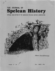
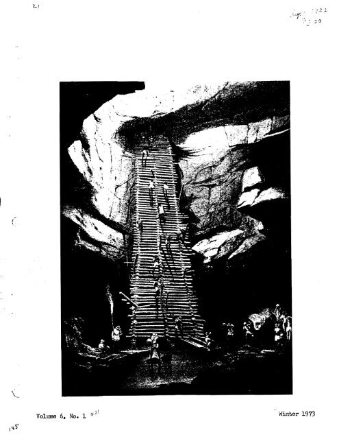
This extraordinary view of natives of Yucatan ascending and descending<br />
a double-width ladder of lashed poles was sketched by<br />
erwood in the winter of 1841-1842. during the famous second expedition<br />
of John L. Stephens. The location is ,lithe old cenote" of Bolonchen <br />
"Nine Wells" - some distance from the ancient and modern townr but<br />
the only one which was reliable during drought. Stephens t description<br />
of the cenote and its cave is among the high points of his oft-reprinted<br />
Frederick Cath<br />
"Incidents of travel in Yucatan", first published in 1841. ASHA member<br />
Jim Hedges has found this notable engraving not only in Catherwood's 1848<br />
rare I 'Views of ancient monuments in Central America, Chiapas and Yucatan"<br />
and a 1965 reprint by Barre'Publishers, Barre, Massachusetts, but<br />
in "Books at Iowa", no. 16.11 April, 1972. (University of Iowa Press,- Iowa<br />
City). Yr editor has seen it only in Von Hagen's "Maya· Explorer: John<br />
Lloyd Stephens and the lost cities of Central America ancYYucatan! (University<br />
of Oklahoma Press, several editions), whence this reproduction.<br />
2.
THE JOURNAL OF <br />
SPELEAN<br />
HISTORY' <br />
Official quarterly publication of the American Spelean History Association<br />
President Secretary-treasurer Editor<br />
Dr. John F. Bridge Peter'M. Hauer Dr. William R. Halliday<br />
2. 06 W. 18th Ave. 12. 7, So. 2. 7th 1117 36th Avenue East<br />
Columbus, Ohio Harrisburg1 Penna. Seattle" Wash. 98112.<br />
,Volume 6, No.1<br />
Janu - March<strong>1973</strong><br />
TAB OF CONTNTS<br />
4 Meramec Cavems, Two Hundred and Fifty Yearsot History by Dwight Weaver.<br />
16 Reprt Section.<br />
23 Wht Cave is This ?<br />
24 'Colloquy.<br />
3
ABSTRACT<br />
MERAMAC<br />
CAVER NS<br />
TWO HUNDRED AND FIFTY YEARS OF HISTORY<br />
Part I - 1720 to 1875<br />
Meramec Caverns is one of the nation's most celebrated caves.<br />
It is Missouri1s most prominent commercial cave attraction and<br />
in all probability was one of the first major cave discoveries on<br />
the North American continent. Its history dates from 1720 and<br />
the days of Philip Renault. The first 155 years of its story include<br />
saltpetre mining, gunpowder making and the legendary<br />
exploits of Jesse James.<br />
Part II - 1875 to 1933<br />
During the turn of the century years Meramec Caverns was a<br />
popular wild cave attraction for the people of St. Louis as well<br />
as the people of its local area. It was the scene of many activities<br />
including dances, parties, picnics, weddings, and social<br />
and political gatherings. A wooden dance floor was built inside<br />
the cave as early as 1893.<br />
Part III - 1933 to 1972<br />
Meramec Caverns was purchased by Lester B.Dill in 1933. With<br />
the help of his family and a partner. the cave was opened to the<br />
public in l935. Its development and promotion has been a continuing<br />
drama for nearly 40 years. Its promotion has earned it a<br />
unique place in the annals of commercial cave histories. Patterns<br />
of cave promotion pioneered by its developers have set examples<br />
followed by many caves opened commercially in more recent years.<br />
C)<br />
Part IV<br />
-<br />
Personalities and aspects of<br />
c o:m:me r ci a1 ization<br />
The modern history of Mera:mec Cc.verns is the life stories of<br />
Lester B. Dill and Robert Hudson. In legend, the infa:mous have<br />
crossed its splendid corridors; in :more recent times :many notables<br />
have also become a part of its past, such as televisionls<br />
fa:ed ·Lassie, and the im:mortal Kate 5:mi tho Others who have<br />
become linked with the cave's history incl ude Rory Calhoun,<br />
Charles Laughton, The Ames Brothers,. Pearl Bailey, and Art<br />
Linkletter.<br />
The development of Meramec Caverns has peaked, in all probability,<br />
and its future does not suggest a higher level of commercial attainment.<br />
---- Dwight Weaver<br />
4
HERAI''IC<br />
CAVERNS<br />
TWO HUIDRED AND FIFTY YEARS OF HISTORY<br />
Part I<br />
by Dwight lveaver<br />
1720 -- 1875<br />
Meramec Caverns is Missouri's most prominent cmmnercial <br />
cave and one of the nation's most celebrated attractions of <br />
its type. Large, lengthy and unusually well decorateq for <br />
a Missouri cave, it is located south of st. Louis about 60 <br />
miles along I-44 at Stanton, Missouri. Situated in Franklin <br />
county and just outside the borders of the Meramec State <br />
Park, the cave is along the banks of the Meramec River. It <br />
has been open to the public since 1935. <br />
The early history of Meramec Caverns is a fragmented <br />
story. References to the cave predating the Civil War period <br />
are few. Commercial development of the cave has made <br />
potential artifact· sites within the cave inaccessible. A <br />
. proper investigation of the cave's archaeological potential<br />
has not been made.<br />
In 1963, however, during one phase of commercial work<br />
inside the cave, Indian remains were found and 'partially<br />
recovered. These remains, those of a young Indian, were found<br />
in a shallow burial about 270 feet back inside ,the cave entrance.<br />
The site was studied by the Archaeological S ocie ty<br />
of Missouri and a report later issued which stated that the<br />
remains were those of a "bundle burial".o<br />
The first aborigine inhabitants of Franklin county were<br />
the Moun Builders. Later Indian inhabitants included the<br />
Delaware', the Shawnee and' the .Osage. The predominate. Indian<br />
culture was the Osage when Spanish and French traders-,and<br />
miners began frequenting the region n the early l700's.<br />
"' " ' "<br />
The Indians' of the region were familiarwith Meramec<br />
Caverns. When the first white men journeyed up the Mississippi<br />
River it is said that they were ,told by the Indians "of a<br />
grea t cave said ••• to contain the lead mineral galena". _ Also<br />
the Indians, say the traditions, held the cave as the home of<br />
.<br />
their god "Ucapago".<br />
Thus it was that knowledge of the cave spread up and <br />
down the Mississippi Valley and eventually gave birth to <br />
Spanish tales that the cave contained gold and silver. This <br />
led'to the cave's early discovery. <br />
.<br />
Discovery<br />
The discovery of Meramec Caverns must have been coincithe<br />
first explorations up the Maramec Rivr which<br />
dental with<br />
empties into the Mississippi River just below the city of<br />
5
st. Louis. The river originates northeast of Salem, Mo.<br />
in Dent county and has a total length of about 240 miles.<br />
The river is fed by more than forty springs, Meramec Springs<br />
near Steelville being the largest.<br />
Discovery of the cave came shortly after the year 1700.<br />
The precise date has not been established. Certainly the<br />
discovery came no later than 1730 and in so doing, it became<br />
one of the first major cave discoveries on the North American<br />
continent. (There are few American caves as prominent as<br />
Meramec Caverns with a known history and/or discovery tjme<br />
that pre-dates 1740.)<br />
The Meramec River was discovered by Father James Gravier<br />
in the year 1700 while he was one a voyage from the country<br />
of Illinois to the south of the Mississippi. Le Sueur, who<br />
ascended the Mississippi River during the same year J wrote,<br />
about the Meramec River and its lead mines in his journal.<br />
Father Jacques Marquette, a Jesuit missionary, is sometimes<br />
credited with the discovery of Meramec Caverns because<br />
he was one of the first white men to explore the lower reaches<br />
of the Meramec Ri ver. The credit is more properly given to<br />
"Jacques" Renault, or Philip Francis Renault.<br />
This Man Called Renault<br />
A. popular version of the local history says Itthe l"1eramec<br />
Caverns were first discovered by Jacques Renault of Kaskaskia,<br />
Illinois in l716tt• Promotional literature distributed by the<br />
operators of the cavern has, for many years, perpetuated the<br />
Jacques Renault name. Floyd Shoemaker, a prominent Missouri<br />
historian, in referencing the caverns in 1943 amitted the name<br />
"Jacques" when refering to Renault's na in association<br />
with the caverns.<br />
C·" '.. ,J<br />
The name ttJacques" was common among the early lead<br />
miners of the Meramec Valley. Tradition seems to have confused<br />
the names.<br />
The Renault in question --the discoverer of Meramec <br />
Caverns -- was actually Philip Renault, a mineralogist, banker, <br />
silver prospector, lead miner and gupowder manufacturer of <br />
considerable note. <br />
Philip Renaultame into the Mississippi Valley in 1719 <br />
with OO mechanIcs, miners an labalers (som ot whi_re<br />
sIaves) to exo1t th ric lead and eRPpe resources of<br />
southeastern Missouri. He was active in=te earlybistory of<br />
Kaskaskia, Illinois and Ste. Genevieve, Missouri. He was<br />
initially attracted by rumors carried to France that Missouri<br />
mines and caves on the Meramec River contained gold and<br />
silver. Renault and his men mined lead in both the Meramc<br />
6
and Big River valleys bore 1732, made salt on Saline Creek,<br />
and established the first saltpetre minin unpowder<br />
making ope a lons in Mlssour a He t of the Miss ss pp.<br />
The actual discovery of Meramec Caverns by Renault<br />
occurred sometime during the early 1720's. It was not until<br />
1720 however, that Renault was sent into the Meramec Valley<br />
region by the Mississippi Company of Kaskaskia to exploit<br />
the lead deposits. !fHis route to the lead country was up<br />
the Meramec • • • " Renault left little of the valley unexamined.<br />
He claimed in 1725 that he was producing 1$00 pounds of lead<br />
a day. '!e "mines" were surface deposits that demanded no<br />
capitol and very little special skill. From this time on these<br />
min es were worked in Itdesultory fashion" by small groups from<br />
Kaskaskia.<br />
French rule in the valley declined in the late 1750's.<br />
By 1763 France has withdrawn from the mainland of North<br />
America. Spanish influence became prominent in the 1760's<br />
and it was at this time that Spaniards came into the region.<br />
Tradition says "In 1760, Don Serita Gonzales, with a party<br />
of Spanish miners, used the cave for a base of operations for<br />
lead mining in Missouri".<br />
Lead, red hematite, copper and barite is common in the<br />
Meramec Caverns locale. Copper and lead mining' occurred both<br />
north and south of the cave.<br />
South of the caverns a few hundred yards is the mouth of<br />
Copper Hollow, a deep valley about. one mile long which contains<br />
the obscured remains of an open-pit copper mine and<br />
smlter. The earliest diggings of the locale may have been<br />
here. Henry R. Schoolcraft, a geologist who visited the<br />
region of Meramec Caverns in 1819 reported that the lead mines<br />
of the area were operated before the year 1800.<br />
Copper was also found several miles north of te caverns<br />
and it is likely that the French and Spanish knew of these<br />
deposits also. These deposits more recently became known as<br />
the Stanton Copper Mines after John Stanton, a well known<br />
pioneer of the region. When copper mining was in progress<br />
during the 1700's, Meramec Caverns was ideally located for<br />
use as storage and shelter.<br />
The copper mines were eventually abandoned by both the<br />
French and Spanish but re-activated in the 1800ls by John<br />
Stanton. Stanton operated his mine for many years and a large<br />
amount of copper-was produced and hauled to.st. Louis in<br />
wagons. John S tanto • w th ha<br />
Stanton, Mo., the nearest c ommu1ty to Merc Cavenns<br />
(less than 3 miles), was originally known as Reedsville, a<br />
name it took from Silas Reed. Reed, a physician born in 1810,<br />
7<br />
\\
operated the copper mines in 1856. The name Reedsville was<br />
changed to Stanton Copper Mines in July of 1856, and then to<br />
Stanton in 1857. The town of Stanton, in the beginning<br />
years of the Civil War, was the largest population center<br />
in Franklin county and therefore created much activity in<br />
the vicinity of r-teramec Caverns.<br />
Gunpowder Making<br />
-<br />
Gunpowder and saltpetre mining was an<br />
manUfacturing<br />
industry associated with Meramec Caverns in the early years.<br />
The beginning of the enterprise probably came as early as<br />
1725 shortly after the cave's discovery, but it was not until<br />
1600's<br />
the early that the industry gained its real prominence.<br />
As earl newspa er article reported that "Fisher! e,<br />
ve<br />
pp ne ivan<br />
were famous oweer rom 1810 0<br />
Sullivan<br />
/' s about the same<br />
averns as is the<br />
tom of Stanton.<br />
It.<br />
The gunpowder making industry apparently flouriShed in<br />
three distinct periods at the cave: (I) the post revolutionary<br />
period, (2) the War of 1812, and (3) during the Civil War.<br />
Philip Renault initiated gunpowder making at Meramec<br />
Caverns and it was this enterprise that gave the cave its<br />
original name, Saltpeter Cave. It was renamed Meramec Caverns<br />
by Lester B. Dill in 1935 when the cave was first opened to<br />
the public. Goodspeed (1888) says "Saltpeter Cave is a<br />
large opening below Fisher's Cave. It is entered from near<br />
the river ••• Gunpowder was made in this cave at an early date."<br />
The gunpowder produced by Renault's men was crude but<br />
adequate. While the lions share of this product was for the<br />
use of Renault as his crews, there was also a ready market<br />
among the hunters and trappers. Same of the powder was also<br />
shipped to Kaskaskia, Illinois and Ste. Genevieve, Missouri.<br />
There were two routes: one, down the Meramec River-to the<br />
Mississippi River and then to Kaskaskia by boat, and two,<br />
overland along a rough, hazardous trail that struck south and<br />
east of the cave. Pack antmls and oarts, Which the Indians<br />
called barefoot wagons, carried the gupowder via lead and<br />
oopper mining sites along the headwaters of the Big River.<br />
The making of gunpowder at this period was seoondary to<br />
lead mining, however, a necessary element in the fight for<br />
survival in a new and hostile environment.<br />
The ingredients for main gunpowder were easily obtained.<br />
Saltpetre was quickly lixivated from the nitrate-rich 'earth<br />
found in the caves of the locale. Huge, plentiful maple trees<br />
in the Meramec Valley Basin provided excellent charcoal whioh<br />
readily ignited and created very little ash. And the sulphur<br />
was obtained as a byproduot of lead smelting, the principal<br />
industry of the valley. Breckenridge (1925) says "The lead<br />
ore of Missouri is principally pure galena and it is probable<br />
8<br />
'- j' ",
that from the year 1720 when Rena ult and La Motte opened and<br />
worked the lead mines in this region on a large scale and<br />
roasted the ores therefrom to eliminate the sulphur, they,<br />
as well as those who came after them, during the hundred<br />
years or more succeeding, make their own gunpowder, using<br />
the waste product sulphur in its manufacture ••• "<br />
The leaching of cave earth requires a plentiful water<br />
supply. There were two adequate sources at Meramec Caverns#<br />
one, the Meramec River which passes directly in front of<br />
the cave mouth, and two, a spring-fed stream about 800 feet<br />
back inside the ca ve.<br />
Vats for leaching were probably constructed of wood.<br />
Oak trees were plentiful to supply the right kind of lumber.<br />
The most suitable location for the leaching activity<br />
would have been in a large chamber about 300 to 400 feet inside<br />
the cave. Today, these chambers are known respectively<br />
as The Ballroand The Gunpowder R o om.<br />
Old ters say that remnnts of the vats were once to<br />
be seen in the cave but that social activities held in the<br />
cave by community groups before the turn of the century saw to<br />
the destruction and stealing of these valuable. old relics.<br />
A lack of re1'erences to saltpetre mining at the cave<br />
during the latter l700ts suggests that by 1760 the enterprise<br />
had laded into memory, but the War of 1812 created a great<br />
demand for gunpowder, it Is said, and this sparked a renewed<br />
effort to utiliEe the nitrate deposits in caves along the<br />
Meamc River. Once again saltpetre mining and powder making<br />
is believed to have begun at Meramec Caverns.<br />
By the year 1816 several gunpowder plants were in_operation<br />
in Missouri along the Gasconade, Mis souri and Meramec Rivers.<br />
General William H. Ashley was operating a ,powder plant at<br />
Potosi, Missouri at this time, and Augustus Chouteau was<br />
purchasing gunpowder for his Powder Magazine in st. Louis.<br />
Of this period Schoolcraft (1818) wrote tl Tbree saltpetre<br />
caves are worked in Washington county, Missouri territor7.<br />
It •<br />
They are situated on the Merrck {sic) •• Franklin county<br />
was eventually created from territory within Washington county.<br />
And, at this time, there was gunpowder making going on<br />
near Newport, now Dundee, at Molino, Youngs Mill and "Spring<br />
Creek Mills" north of stanton. ll of these were in the general<br />
region of Meramec Caverns. Other nearby caves reportedly<br />
supplying saltpetre for thes.4$powder mills include Copper Hollow<br />
Cave, Green's Cave, Bat Cave and Fisher's Cave.<br />
After the War of 1812 the price of gunpowder fell considerably<br />
and by 18)0 saltpetre mining at Meramec Caverns had,<br />
for a second time, faded into memory.<br />
9
The approach and outbreak of the Civil War gave altpetre<br />
mining its third and apparently final birth at 14eramec<br />
Caverns. According to legend, it was at this time also<br />
that violence and bloodshed first ent ered into the cave's<br />
long history.<br />
Civil<br />
War<br />
Modern day promotional literature has so embellished<br />
the his tory of the cave for this per iod of time that is not<br />
yet, and may never be possible to sift the facts from fiction.<br />
In the cave's commercial brochure (1971) it reads "Very<br />
lit tle exploration was do ne until 1862-1864, during the Civil<br />
War, when gunpowder manufacturing was at its height at the<br />
cave. The Union forces set up powder kilns and leaching vats<br />
in the cavern; as well as an underground railroad sta tion.<br />
Thousands of slaves found freedom via this roote.1t An earlier<br />
version by the cave's promoters (1955) simply states that<br />
It<br />
"The Union Army utilized the caverns as a gunpowder mill •• •<br />
It<br />
And in 1948 •••in the Civil War period • •• it was used as a<br />
gunpowder works •• • tt And even earlier (1942?) " Duing the<br />
Civil War a gun powder plant was established in the cavern<br />
but was abandoned after a portion of it blew up .t t<br />
The mining of saltpetre and productio n of gunpowder at,<br />
in or near Meramec Caverns is generally assured to have taken<br />
place before and during the Civil War. But thepe is question<br />
as to who conducted the enterprise. It would seem unlikely<br />
that the Union Army officially started the operation as the -<br />
above has suggested. Faust (1967) states that "There is no<br />
..<br />
known instance that the Federals, at any time, attempted to<br />
opera te any eave saltpetre recovery operation, even those<br />
captured from the Con federates.tt He further sta tes that liThe<br />
North seemed to evidence only destructive action toward such<br />
installations rather than recognition and utilization of' a<br />
valuable source of raw material.1f<br />
There is evidence, however, to suggest that at least<br />
Confederate sympathizers of' that area set up and maintained<br />
the operation at Heramec Caverns f'or a period of' tim, but<br />
more toward providing for their own protection than to supply<br />
Union or Confederate forces with gunpoWder.<br />
The presence of powder mills along the Heramec after<br />
1810 seems to be an e,stablished .fact, but a search o.f early<br />
records on Franklin count,., in which Meramec Caverns is<br />
located, reveals little information on this. Most sources<br />
o.f informtion published since the cave's cercial development<br />
have added no new inormation and Simply clouded the is sue.<br />
0<br />
And what about the slaves? The previousl y quoted source<br />
said, that thousands ou freedom by using the eave as a<br />
hideout. Whether or not the eave was actually a station of<br />
the Underground Railroad is unverified. It certainly could<br />
not have been during the first part o.f the war when Confederate<br />
sympathizers controlled the cave.<br />
10<br />
('.
When Missouri entered the Civil War it was a divided<br />
border state and it is int eresting to note that while<br />
Missouri, as a state, had a slavery percentage of only 9,,<br />
Franklin county had a slave population of more than 13%,<br />
this being a carry ov er from the time of French oc cupation<br />
in the l700ls when slavery was introduced to th e territory<br />
by Philip Renault.<br />
A number of prominent Franklin county residents were<br />
slave owners. The slaves served two purposes, as help in<br />
the lead and copper mines of the region, and as house servants.<br />
The slave servants were a mark of wealth and social<br />
standing.<br />
So the slave percentage was high in Franklin county and<br />
the use of same local rendezvous on the flight to freedom<br />
seems plausable. But thousands? When this item was added<br />
to the promotional material on the cave in the 40's the<br />
figue was hundredsl<br />
Just as the state of Missouri was divided, so was Franklin<br />
county. And it is in the records of this division that<br />
clues can be found which suggest sometll.ing abou t the powdlr<br />
mill at Meramec Caverns during the War.<br />
.<br />
The nearest communities to Mergmec Ca verns then and today<br />
are Stanton and Sullivan. It is generally belie ved that John<br />
S tanton, who operated the Stanton Copper Mines, was also<br />
operating the powder mill at Maramec Caverns at the approach<br />
and outbreak of the war. Rayburn (19.54) says that this powder<br />
.<br />
mill was established in the l8.50·s.<br />
< \<br />
Another individual believed to have been involved in<br />
the operation was Stephen Sullivan who founded the Sullivan<br />
community in 1858. In the 1860' s Meramec Caverns was situated<br />
about halfway between the homesteads of John Stanton and<br />
Stephen Sullivan. The Freemont Trail connected these two<br />
places and the entrance of Meramec Caverns cam within oak<br />
throwing distance of the trail.<br />
When the war arrived there were divided factions in<br />
Franklin county. Writes Bruce Catton (196.3) "Missouri was<br />
divided into factions and sub-i'actions, with almost everybody<br />
in the ata te • ••<br />
either making war or preparing to make war-<br />
on his next-door neighbor, as of ten as not." Franklin county<br />
was no exception and the most notable confederate spathizers<br />
were Maupins, Stantons and Sulli vans. 6,000 Franklin county<br />
men eventually joined the Union forces but less than 700 fought<br />
for the Confederacy. However, the large slave holders at<br />
the county were in this minority. They controled the wealth<br />
and were also the same in dividuals historically associated<br />
with powder manufacturing in that region.<br />
11
It is suggested that John Stanton, ha v ing . established<br />
the powder mill operation before the war, was J o ined in this<br />
labor by Stephen Sullivan. They and their confederate helpers,<br />
however, were not strong enough to hold the gunpowder plant .<br />
By the end of 1862 federal patrols had immobilized most<br />
confederate sympathizers in Mis souri an d driven all but the<br />
more hardly guerrilla bands out of the sta te.<br />
('" ",'/<br />
It is interesting that a legend survives which says that<br />
Stephen Sullivan was execu ted by the Federal troops because<br />
he manufactured gunpowder for the Confederac y. This execution<br />
is generally believed to have taken place at Meramec Caverns .<br />
The Coming of General Sterling Price<br />
On September 30, 1864 General Sterling Price staged a<br />
raid in Franklin county. Sterling Price, who was the Governor<br />
of Misso uri fram 1853 to 1857, was an active political figure<br />
in Missouri before the war. The approach of the war however,<br />
changed Price frm a moderate compromiser into a militant<br />
pro-southerner. By March of 1862 Price had left the state<br />
to fight for the Confederacy. Although he won no accolades<br />
from the West Pointers in the Confederate Army, he was a hero<br />
to the Guerrillas and southern sympath izers wh o usually<br />
peopled his command.<br />
By 1863 and earl y 1864 when the Missouri Militia had<br />
the number<br />
dr iven most of the CSonfedera tes from the sta te,<br />
of Federal roops was consderably reduced in the state. It<br />
was at this time that Sterling Price staged a raid in Missou ri,<br />
hi s second and most no torious. He came into Missouri fram<br />
Arkansas through the southeast part of the state, defeated<br />
Federal troops at Pilot Knob, and moved into Franklin county<br />
where he stayed for four days while preparing to move on west<br />
and capture Jefferson City, a task he later failed at.<br />
, '<br />
Legend and promotional literatue for Meramec'Caverns<br />
has added Price I s raid to the history of the caverns. "In<br />
18, the Quantrill Irregulars, under the command of General<br />
Price, of the Confederate Army, captured the gu powder mill<br />
and plant," claims the cave's brochure. And, it was at this<br />
time, according to the same authors, that "Jesse James; Frank<br />
James, Frank Dalton, and the Younger Brothers were members<br />
of the dreaded Quantrill Irregulars, and thus became acquainted<br />
with the caverns."<br />
Quantrill's Irregulars<br />
-<br />
Sullivan was the rendezvous of the 63 Enrolled Missouri<br />
Militia and other military organizations in 1864.<br />
It was for<br />
this reason that Sterling Price spent considerable tim in<br />
the area. During his four day stay some 60 local men were<br />
killed by his troops and nearly $500,000 in personal<br />
property<br />
was destroyed. If Quantri ll and his Irregulars were among<br />
Price's 16,000 men at the time, it has not been brought to<br />
light.<br />
12.<br />
.:'<br />
l
And in regard to Jesse James and other Guerrillas wh o<br />
rode under Quantrill from time to te during the War, his<br />
presence among Price's men at the ttme of th e raid in<br />
Franklin county is also highly doubtful. William Connelley,<br />
an authority<br />
Border Wars,<br />
on Quantrill and auhor of luantrill and the<br />
lIs. "to'O"no<br />
says that Quan trill's Querr part<br />
whateverTi the invasi on of Missouri by Price" even though<br />
their original intentions were o do so.<br />
Jesse<br />
James<br />
From a few sparks , it would seem, has burned a mighty<br />
legend, a tale so nurtured by its tellers and mythmkers that<br />
it has become a classic. Even if there were no seeds of fact<br />
upon which the legend was sown, its magnitude is so great,<br />
that one cannot examine it under the cold light of day without<br />
being emotionally intrigued. Tens of thousands, perhaps<br />
millions of visitors to modern day Meramec Caverns accept<br />
the Meramec Caverns legend of Jesse James as fact)and whether<br />
tre or not, its popularity is undeniable. It is an interesting<br />
st.ory, amazingly contrived and beautifully told by those who<br />
guide visitors through the cave. This writer knows fram<br />
personal experience for he once guided at Meramec Caverns. And<br />
for %ndividuals who take pleasure in the richness of Amrican<br />
folklore, the truth fullness of the legend is unimportant.<br />
There is enough mule in th is Missouri writer to believe<br />
that Jesse James did indeed hide in numerous Missouri caves.<br />
Paul Weiman, a popular western his torIan, has done considerable<br />
research on the dynasty of outlaws that thrived in Missouri<br />
and the Ozarks between the years 1836 and 1936. His material<br />
pro ves that Missouri is so steeped in outlaw histo ry that<br />
it has frequently been rerered to as The Outlaw or Robber<br />
state. In recent years so many caves ha ve been discovered<br />
in Missouri that its favored nickname--The Showme State-- has<br />
almost been entirely usurped by The Cave state. A ..librarian<br />
for the Missouri state Historical SOCiety recently told this<br />
writer that she was happy that so many caves had been found.<br />
She was tired, she said, of hearing Missouri refered to as<br />
The Outlaw state.<br />
According to the promoters of Meramec Caverns, uIn the<br />
earl y 1870's he (Jesse James) and his band used the caverns<br />
on numerous occasions because it aff orded a complete hideout<br />
for men and horses. In 1874," they claim "after a train<br />
robbery at Gadshill, Missouri, the gan g was tracked to the<br />
caverns by a possej and after a seige of three days, they<br />
escaped by an unnown route which remai ned a mystery until<br />
the redisco very of this huge passage with its underground<br />
river in 1940 •••"<br />
The groundwork for this le gend was laid in the years<br />
1940-4 when the lowest level of the cavern along the Underground<br />
river was opened to the public. Documentation for<br />
the story has not been made available. News stories of that<br />
day, however, give an interesting picture.<br />
13
Prior to 1940 when th e underground river was<br />
concealed<br />
by a siphon pool toward the rear of the cavels so-called "second<br />
level" I the Jesse James legend was notably absent from news<br />
stories and promotional literature. (The cave was opened to<br />
the public in 1935 and showed levels two,three,four and five<br />
The story of how<br />
this siphon pool was breached was told by J Harlan Bretz in<br />
The Caves of Missouri (1956). In his account he states that<br />
prior to 1'9 "the lowest level had been entered by another<br />
and very difficult route" which was along the course the<br />
river takes to its resurgence along the cave bluff a tew yards<br />
down valley from Meramects huge opening. Contrary to news<br />
releases, the Underground River section was not a new discovery<br />
in 1941 when Bretz helped force the siphon. And, in<br />
the pre-194l , Paul Bunyan and Pecos Pete yarns were the<br />
stories of the day; but with the advent of Jesse James,Pau1<br />
and Pete went to their literary demise having been shot down<br />
by a more notorious character.<br />
and was promoted as a 4-story wonder cave.)<br />
In July, of 1941 a Berwyn, Illinois news story on Jesse<br />
James said ' • • •Even impossible stories are now being circulated<br />
about the Hero of our boyhood. In one two-gun-bang-bang<br />
story he rides full tilt into a cave whose biggest and only<br />
opening·is about half big enough to accomodate a fair sized<br />
rabbit. And speaking of cave entrances brings our story of<br />
Jesse to the entrance of Meramec Caverns at Stanton, Missouri.<br />
Jesse used the cave and with good reason. His little band<br />
could really lope through its entrance. In fact they could<br />
ride back into the cave for almost a quarter of a mile. Once<br />
inside they were safe for they knew the cave • • • Probably some<br />
of the loot is still in Meramec Caverns -- perhaps mouldering<br />
there in same rocky recess... Could be that time will bring<br />
to light a saddle or a gun or a hat that Jesse took inside<br />
and left as a souvenir of his visit ••• "<br />
r<br />
C·' .,.;<br />
Gathering no dust, the story was repeated and the<br />
suggestions were well taken. In November of 1941 a story<br />
in the Watchman Advocate tells about a visitor to Meramec<br />
Caverns who "explained that he wanted to find and take home<br />
the hat Jesse James had lef't hanging on the "Capitol Domen<br />
(a large stalagmite on the 4th floor). Shortly thereafter<br />
a humorous article about a group of Navajo Indians that had<br />
visited the cave states that one of the Indians "spent most<br />
of' his time looking f'or the gun Jesse James is supposed to<br />
have lef't in the cave."<br />
The f'irst big news releases in the early part of 1942<br />
on the discovery and opening of the Underground River section<br />
made very little mention of Jesse James but by years end the<br />
cat was out of' the bag.<br />
A fistfull of relics had turned up.<br />
About 21 of' them in al,l. The St.Louis Post-Dispatch said<br />
"Jesse James J MissouriS own number 1 bad "man, Is sala to have<br />
used the cave as a<br />
into which horses could be l:un<br />
hideout because it was the only place<br />
at a full gallop_ He is<br />
thought to have taken refuge here aft er one of his faroUS<br />
train robberies whither he was tracked by a posse. After a<br />
three day seige he escaped through one of the lit tle kn wn<br />
passageways which has recen tly been discovered • • • II<br />
A po int of fact.<br />
There was a train rob bery by the James<br />
gang at Gads Hill, Missouri in 1874. On the morning of Jan.<br />
31, 1874 the James gang captured the small whi stles top of<br />
a town and rob bed the incoming Iro n Mountain Express . And<br />
like the man who has made a fortune off of th e legend of<br />
Jesse James--Dill--Jesse himsel f Was a sh owmn. The robbery<br />
netted onl y $2,000 in loot but Jesse handed the train 1 s<br />
engineer a press release on the robbery for the benefit of<br />
news reporters I<br />
Gads Hill is located 75 miles south and east of Meramc<br />
Caverns as the crow flies and in 1874 it was a rough trip<br />
between the two points unless one took the better trails<br />
and roads. The qU1Istion is, did Jesse? Wh t hap pened after<br />
the robbery seems to be everyone guess.<br />
In 1961 Lester B. Dill, Missou ri's own Number One Cavemn<br />
(the P.T.Barnum of the Cave World and the Gimmick Man of<br />
the Underground» )<br />
and the promoter or Meramc Caverns.wae<br />
quot ed in a nationwide news story on the particulars involving<br />
the' discover l of the underground river and its reputed "Jesse<br />
James relics t . Said Mr. Dill "we found the strongbox, the<br />
lock and old guns there (meaning around Loot Rock where the<br />
story comes to a climax for Visitors), when we dug through.<br />
The lock (on the stron gbox) was traced to the Denver and<br />
Missouri Company, robbed by the James gang in 1874. The cave<br />
was raided by Q.uantrill' s Raiders, Rebel marauders who<br />
numbered the James boys among them .<br />
"From. this room, we discovered the undergrond ri1[er •••<br />
then we uncovered the incident of,)the James boys beng<br />
trapped in the cave after a robbery in 1874. Whn the posse<br />
entered the cave atter three days of seige, Jesse and Frank<br />
were gone and all that was left were the horses and empt y<br />
strong box.1t<br />
Dill also stated that the gang had escaped by wadiii<br />
and sw1mming the underground river to its exit 'a balf-mile<br />
away trom,the "room".<br />
It's another one of those stories of which came first,<br />
the chicken or the eggS But so successfully has Dill sold<br />
his story to the public that in 1969 a survey reportedly<br />
taken at the cave, showed that 9 out of 10 tourists vi sit<br />
Meramec Caverns because of Jesse James. Dill was quoted as<br />
saying t t lf it wasn.t for Jesse, my cave woul d be just another<br />
.<br />
100,000,000-year-old hole-in-the-ground. It<br />
(end of Part 1)<br />
15
REPRINT<br />
_<br />
SECTION:<br />
FIELD<br />
INVESTIGATION REPORT<br />
NEFF'S CANYON CAVE<br />
Wasatch <strong>National</strong> Forest<br />
(near Salt Lake :City, Uth)<br />
Investigation by<br />
<strong>National</strong> Park Service<br />
Region Three Personnel<br />
SepteIlber 1951<br />
Investigating Party:<br />
ThOIlas A. Walker, Superintendent, Timpanogos Cave<br />
<strong>National</strong> MonuIlent<br />
Lee Walker<br />
R. Taylor Hoskins, Superintendent, Carlsbad Caverns<br />
<strong>National</strong> Park<br />
M. V. Walker, Park Naturalist, Zion <strong>National</strong> Park<br />
James B. Felton, Chief Ranger, Zion <strong>National</strong> Park<br />
Grant Clark, seasonal ranger, Zion <strong>National</strong> Park<br />
Harold A. Marsh, Lands cape Architect, Region Three Office<br />
John E. Kellg Park Planner, Region Three Office.<br />
(oIlitted<br />
illustrations)<br />
Photography and sketches<br />
by John E.· Kell<br />
rl<br />
V<br />
Photo No. 1 - Packing gear on hoI's e for trip to cave.<br />
Photo No. 2 - Much of the trail to Neff's Cave is through dense oak<br />
brush.<br />
Photo No. 3 - Harold Marsh wading through underbrush near top<br />
of ridge. Cave entrance is over crest of r-idge and slightly<br />
downgrade froIl this point.<br />
Photo No. 4.- General view at Cave entrance. Cave follows this<br />
fracture line. Apparent entrance in foreground choked with<br />
rock .. actual entrance through sIlal l holes at ItA" or "B".<br />
Photo No. 5 ... General view inside Cave. Floor and opening continue<br />
about 15 feet below rocks in foreground.<br />
Sketch showing relationship of Cave to photo above. <br />
Plate til .. Location Ilap. <br />
Plate ti2 - DiagraIlIlatic geologic section <br />
Plate 113 ... DiagraIlIlatic sketch, Neff's Canyon Cave.<br />
Plate ti4 ... Typical sctions, Neffls Canyon Cave.<br />
16<br />
c:·
SUMMARY<br />
Investigations of Nef£ls Canyon Cave <br />
September 17 & 18.<br />
1951 <br />
Location<br />
NeHls Canyon Cave, sometimes called Mt. Olympus Cave, is located in<br />
the Wasatch <strong>National</strong> Forest roughly three miles south and five miles<br />
east of the city limits of Salt Lake City.<br />
Investigation<br />
Monday, September 17, was spent with Forest Service officials and<br />
participating in interviews with representatives of the Geology Department,<br />
University of Utah, and others. Most of the investigating<br />
group, accompanied by Forest Ranger Gardner, went to the Gave, marked<br />
a trail and went inside for a short distance. The actual investigation<br />
was made by the entire group on Tuesday, September 18. The party entered<br />
the cave at 11:10 a. m. and carne out about 3:30 p. m.<br />
NeHls Cave<br />
This is a tent-shaped, or inverted "V"-shaped, cave.<br />
about 550 to 600 feet<br />
onlY'Lee,Walker could worm. his way through. , (Editor's note:,,'The Nar<br />
rows: just beyond the' Double. Pit Room.)<br />
this opening,<br />
about 3:30 p. m.<br />
It changes in<br />
base and height from narrow craw1ways to spots where he base of the<br />
tringle is, perhaps, twelve feet wide with a ceil ing of as much as twentyfive<br />
feet.<br />
The angle is quite steep - estimated to be 45 degrees with<br />
dropoffs of three to thirty feet at varying intervals, making the overall<br />
angle of descent about 60 degrees.<br />
The floor 'is covered with loose rocks<br />
which make inspection dangerou\s. In addition,. the cave is wet and the<br />
rocks are slick, offering, at times, little or no foothold. Vie made the<br />
trip in and out by feeding rope along through the opening and calling<br />
back and forth through the passage asking that the rope be made fast<br />
when it was necessary to use .it to negociate ledges. " The- party stopped<br />
underground where the-.passage was so narrow that<br />
in,what we had seen up to that point.<br />
He;: reported no maJor change<br />
Since.we ·could go no further, plus<br />
the fact that it would have been impossible to get an injured person through<br />
we recalled.Lee Walker, had lunch and returned to the surface<br />
Conclusions<br />
The cave does not have any qualities that are of national iri:lportance . and<br />
we did not discover any portion of the cave that would have an economic<br />
value! as a tourist attraction for Salt Lake City and vicinity. It is dangerand<br />
continued exploration by persons small enough to negociate the<br />
ous,<br />
openings is inviting eventual tragedy. Further explorations should be<br />
discouraged.<br />
17
REPORT OF INVESTIGATION<br />
Following instructions received from the Washington office through<br />
the Regional Director, an investigation was made of Neffls Canyon<br />
Cave near Salt Lake City Utah. The names of those making the<br />
investigation are listed at the beginning of this report.<br />
V( ith the exception of Thomas Walker and his son, Lee, the group<br />
arrived in Salt Lake City, Utah, Sunday, September 16. Monday was<br />
spent in obtaining additional information about the cave.<br />
Since the<br />
cave was located inside the boundaries of Wasat ch <strong>National</strong> Forest,<br />
the group called at the office of Forest Supervisor F. C <br />
the morning of September 17,<br />
he had in his files <br />
Koziol on<br />
Mr. Koziol gave us what information<br />
reviewed the background of other investigations<br />
and suggested the names of two young men living in Salt Lake City<br />
who were anxious to go along as guides.<br />
One of these men expected<br />
to be hired as a guide, the second was willing to go along for the<br />
experience.<br />
We suggested to Mr. Koziol that he refrain from alerting<br />
these men until our plans were more complete and the group later decided<br />
that because of the risks involved tegether with the fact that one<br />
of the boys was only seventeen years of age, it would not be advisable<br />
to take either of the young men along.<br />
Mr. Koziol introduced the group to Ranger Robert W. Gardner and he<br />
assisted with maps and also in locating the entrance to the cave.<br />
After the conference in Forest Supervisor Koziol's office, the party<br />
split into thee groups. Superintendent Thomas Walker, Mr. Felton<br />
and Mr. Clark went with Ranger Gardner to locate a trail or way to<br />
the cave.<br />
o<br />
Superintendent Hoskins and Myrl Walker went to the University of Utah<br />
where they talked to Dr. Ray E. Marsell (two years later a charter<br />
member of the Salt Lake Grotto of the <strong>National</strong> <strong>Speleological</strong> <strong>Society</strong> <br />
editor's note) and Dr. F .. W .. Christiansen of the Department of Geology.<br />
Mr. Marsh and I went to interview Mr. CharlesH. Malmborg.<br />
Mr.<br />
Malmborg is an amateur geologist and a baker by trade. He is currently<br />
employed by the Holsum Bakery and he had prepared the report from<br />
his knowledge of geology and from interviews from students who had<br />
been inside the cave.<br />
Through telephone conversation with the boyrs<br />
mother I learned that the boy suggested by Mr. Koziol was now in the<br />
Army and that his brother, who had made several trips inside and who<br />
would be willing to go along, was only seventeen.<br />
All of the interviews were completed Monday afternoon and the groups<br />
returned to the Newhouse Hotel to complete plans for the investigation.<br />
Because of. the age of the boys suggested as gui des, together with employment<br />
difficulties, we decided against employing anyone as guide.<br />
with the help of Ranger Gardner a trail had been located leading to the<br />
cave entrance, and Superintendent Tom Walker had gone inside for a<br />
short distance. He advis ed that in order to make any kind of an : inves _<br />
tigation we would need additional rope. We purchased a 12 GO-foot coil<br />
of rope and agreed to be ready to start Tuesday morning at 7:00 a. m.<br />
Tom Walker was to secure a pack animal and meet us at the Forest Service<br />
boundary, 18<br />
C"'li<br />
v<br />
o<br />
"'
( . \<br />
We met as agreed on Tuesday morning. September 18, and were able to<br />
drive the pickup to the end of a trail about a mil e or a mile and a half up<br />
Neffls Ccnyon.<br />
At this point we packed the horse with rope and other<br />
equipment and started up the trail.<br />
The advance party reported that<br />
the easiest way to reach the cave was to take the Forest Service trail<br />
up Neffls Canyon almost to the spring, top-over the ridge to the bottom<br />
of a small tributary canyon where the actual ent ranee to Neff's cave is<br />
located.<br />
Because of dense undergrowth more than waist high, it was<br />
necessary to brush out a temporary trail to get the pack animal to the<br />
cave entrance.<br />
We arrived about 10:30, having consumed a little more<br />
than an hour and a half frem the time we left the pickup_<br />
Flashlights,<br />
food and other gear were assembled and we uncoiled the rope and entered<br />
the cave at 11:10 ao.<br />
c:<br />
Superintendent Tom Walker, his son Lee; Taylor Hoskins, and Myrl<br />
Walker entered first. The entrance and many of the passages had to<br />
be negociated feet-first. I followed Myrl Walker and Har-oldMarsh care<br />
behird me. Chief Ranger Felton and Grant Clark stayed on top to feed<br />
rope and equipment into the cave as needed. The cae turned out to be a<br />
fissure, tent-shaped or like an inverted "VII<br />
. The base and height<br />
varied from narrow crawlways to spots about 12. feet wide and with heights<br />
estimated to be 2.5 feet. The floor went downward. at an angle of almost<br />
45 degrees. This general downward incline was punctuated with drop<br />
·o££s of three to thirty feet making the overall downward' angle of descent<br />
average about 60 degrees. The floor was covered with loose rock. It<br />
seemed that the greatest concentration of rock was at the break:in elevation.<br />
It was difficult to negociate these jump -o££s without causing<br />
rocks to diSlodge. In many places rocks had bridged across the ceiling<br />
and in other places rocks three to 12. inches thick remained suspended<br />
overhead at the apex of the inverted "V". Cracks from .one to several<br />
inches wide and too deep to be probed-_by a flashlight beam gave the<br />
"suspended" feeling (see Fig. 3, plate 4). Except for the crawlways<br />
a person could stand erect but in the major port ion of the cave both<br />
walls could be touched by extending both arms. " W edid not find-any<br />
formations of importance or any side passage. The inverted uV" shape<br />
remained throughout with only the base and height changing.<br />
At diff-<br />
erent horizons along the w'a1ls there were tooth-like formations projecting<br />
from the walls that skinned fingers and snagged clothes.<br />
A bout 12.:30 p. m. and a distance of 550 to 6()0 feet underground we<br />
reached a point wher.e the passage narrowed to.an ellipse-shaped tube<br />
with the long axis up,and down.<br />
able to get through this passage.<br />
Lee Walker was the only one who was<br />
He took a lighted lantern to test the<br />
air and went through the passage. He reported that the cave opened<br />
up again, but there were no large rooms or formations different than<br />
those seen up to this pOint.<br />
Since the rest of the party could not get<br />
beyond this point1 coupled with tlie fact that it would have been impossible<br />
to give any assistance in case of injury,- Lee was recalled.<br />
We ,ate<br />
lunch at this point which was as large as any spot dis covered along the<br />
way. The walls of the cave are damp. Water drips at many spots but<br />
we did not see evidence of any growth under the drip-points. Thefloor<br />
of the cave has the apparance of a stream bed and during the spring<br />
runoff, large quantities of water find their way underground through this<br />
19
.<br />
passage. The temperature in the cave is estimated to be about 40 degrees.<br />
The party reached the surface about 3:30 p, m. and we were back in Salt<br />
Lake City by 7:00 p- m.<br />
J<br />
.<br />
It is possible that the fissure extends for several feet or perhaps miles.<br />
It is reported that the boys have reached a point several hundred feet<br />
beyond the point our party reached.<br />
One report is that the place opens<br />
to a large room with high ceilings and a "jump-off where it takes a rock<br />
four seconds to hit bottom."<br />
Such stories lead to speculation about<br />
large rooms or other openings, and a hope of some individuals that the<br />
cave may have some economic importance, Dr. RyE, Marsell, Department<br />
of Geology, University of Utah, has conducted studies with the<br />
State Engineer:s Office and they are convinced t hat the water from Neffls<br />
Cave reappears as the Holliday Springs,<br />
Myrl Walker has written USp<br />
lIThe site known as INeff's Cavel is located near the top of a steep canyon<br />
some distance above Holliday and . near the peak known as Mt. Olympus.<br />
The rock formations all dip very steeply toward the wests being upturned<br />
along the edge of the well known Wasatch fault. The cave, which<br />
is not a solution feature, but rather merely a fissure due to earth movement'<br />
is located in some thin-bedded limestones and shales (Ophir formation?)<br />
which rests on the so-called (Tintic quartzite). The fissure<br />
descends at something like 60 degrees, and is filled and wedged with<br />
many rounded boulders of quartzite. This makes the descent into the<br />
fis sure very difficult and hazardous. Many of these rounded quartzi.te O",l<br />
boulders become loosene d and constitute an ever present hazard, In so<br />
far as could be determined; there is no evidence of the development of<br />
cave formation due to deposition of lime in any form on the roof or cave<br />
walls. There do not appear to be any unique features associated with<br />
the fissure,"<br />
and, . Mr. Hoskins has reported $<br />
"On Septenber 18, we started the investigation, entering the cave at 11:10<br />
a. m., and emerging about 3:30 p. m. The investigation revealed that<br />
this cave was formed by a fault located in quart zite formation with a<br />
very small entrance.<br />
There was only one passageway which resembled<br />
an inverted IIVII, varying in size from a narrow craw1way to a width of<br />
a few feet to twelve feet and the height varying from a few feet tO,as<br />
much as 2 5£eet in one location.<br />
stream bed and silt was noted on the walls.<br />
rock and boulders are located on the floor.<br />
The floor 'of this cave appeared to be a<br />
Many large and small loose<br />
The cei ling in many places<br />
looked none too stable as there were visible many cracks and huge stones<br />
which looked none too secure.<br />
The temperature in this cave appeared to<br />
be some lower than Timpanogos which is 41 degrees and in addition the<br />
cave is very wet.<br />
Only a few formations were observed, the larger being<br />
about 4 to 6 inches long and about the size of a pencil.<br />
The passageway<br />
is on a very steep grade which I judge to be about 60 per cent which makes<br />
it very difficult to traverse.<br />
¥<br />
20 C',
(<br />
{lIn conclusion, it is my candid opinion this cave has no scenic val. ue,<br />
will not by any stretch of the imagination meet <strong>National</strong> Park Service<br />
standards, and is without a doubt the most hazardous cave I have seen.<br />
If it were in a <strong>National</strong> Park Service area, I would recon1n1end that<br />
the entrance be blasted so no one could possibly gain entrance to it.<br />
The inscription above the entrance "Foolls Cave" is a justifiable<br />
des cription ...<br />
There are attached as a part of this report n1aps, sketches. and<br />
photographs of the cave area. All those who entered the cave agreed<br />
that it is dangerous and that there is little evidence to support the<br />
belief that it has any economic value as a tourist attraction.<br />
Approved for distribution:<br />
M.,R. Tillotson<br />
October 31$ 1951.<br />
John E. Kell<br />
Park Planner<br />
* * * *<br />
Editorts note: the report referred to on page l8 prepared by Charles<br />
Maln1borg. was printed in the Decen1ber, 1950 N"S"S. :tews. Other<br />
concepts of the geology and speleogenesis of Neff Canyon Cave appear<br />
especially in the Salt Lake Grotto Technical Not e seriesJ beginning with<br />
its TNstH and 5 (January, 1954). The following is another significant<br />
unpublished report on the early explorations of this, the deepest known<br />
cave in the United States.<br />
August 7. 1951.<br />
The accon1panying sketch bears a date -of<br />
* * * *<br />
"Report of Jack,Eh1ers on Mt. 01yn1pus(Neffts -Canyon) Cave with comn1ents<br />
on'Maln1borg report"<br />
, <br />
.. --<br />
John:Lyon, Jan1es:Lyon._ Jerry Dahlberg, Dick :Maxiie1d, and.Roland<br />
Baxter were with n1e when we entered the cave.onJuly2.9,,1950 • . We<br />
were equipped with three changes of flashlight batteries and 2.40 feet of<br />
3/4 inch n1anila hen1p rope. W e also had an equal an1 0 unt of very light<br />
clothesline rope .. _ We each wore two pair 'of levis and two flannel shirts.<br />
The ten1perature in the cave ren1ains at about 40 0 and we needed1:he<br />
extra clothes for'warn1th.<br />
Before entering the cave, we checked our equipn1ent to n1ake sure that<br />
our haver sacks were secure.<br />
None of us know what we would find that<br />
day but in our group prayer we asked that we would receive the necessary<br />
protection during our adventure. We weref of course, all very excited,<br />
and we didn't find tin1e to worry about a coffee pot or eating anything but<br />
a few raisins.<br />
. '<br />
.. './ ("<br />
The cave has a sn1all entrance directly in the surface of the ground. It<br />
drops vertically for ten to twelve feet but there is strata on which one<br />
can lower hin1self. There is a flat on which to land and then the cave<br />
2.1
egins its descent on a 450 angle; of course there are many variations 0<br />
Undoubtedly Mr. Malmborgls party never l:eached the place where the<br />
boys were stranded if they were only 2,000 feet in the cave. We used<br />
50 feet of rope to get down the 100 foot drop they speak about, The lardrop<br />
they speak about (The Great Pit - W, R,H.) is some ZOO feet high.<br />
We had ten feet to spare on our 290 foot piece of rope when we reached<br />
the bottom of this drop. It is here where the boys who were stranded in<br />
their last trip stayed until rescue came.<br />
I may state too, that none of the Deputy Sheriffs or other rescue personnel<br />
entered the cave to rescue the boys. James Lyon, the brother of one of<br />
the boys stranded in t:he cave, entered the cave by himself and helped<br />
the boys from the bottom of the long drop. On our last espedition, we<br />
left Jerry Dahlberg$ Dick Maxfield and Ronald Bxter at the top of this<br />
drop in order to pull uS up some four hours later, We were in the cave<br />
for more than nine hours and we estimated our distance in to be about<br />
two miles. I will draw a graph of the cave; I can explain it better this<br />
way than in words .. (Editor1s note his sketch is readily identifiable,<br />
showing clearly that the party left a tin can regi ster at about -825 feet;<br />
the top of the pit entering the Big Room)"<br />
The boys at the top of the large drop (The Great Pit) let our 3/4 inch rope<br />
down to us on the clothes line rope and we then reused it on the last two<br />
drops we descended.<br />
On our return the boys pulled up the 3/4 inch rope<br />
on the clothesline rope and secured it at the top.<br />
up the large drop one by one.<br />
Then we were pulled<br />
When we again saw day light. we were very<br />
tired but we had no cuts nor bruises nor were the hours spent so "tortuous"<br />
that we didnt enjoy every minute of our experience.<br />
Strong clothes<br />
must be worn however. , , (<br />
After conversing with Armand Ea rdly at the Department of Geology at the<br />
University of Utah, I am sure that under these black limestone deposits<br />
lie the treasure which we are seeking {understood in Salt Lake City to<br />
have been another Timpanogos Cave - W cRoHo}<br />
fresh air proves another entrance.<br />
The constant breeze of<br />
There is another cave in Neffs canyon<br />
where it boxes off. Mr. E.,G, Erickson has been in this cave ana he claims<br />
that even though he was only in 650 feet, the cave was some ·30 feet high and<br />
ZO feet wide and that the icicles were profuse both from the ceiling and<br />
floor. He had specimens of the formations. He wouldn It take me to the<br />
place because of physical inability but he descri bed it as being several<br />
hundred feet up the south side of Neffs canyon a few hundred feet before it<br />
boxes off.<br />
C· ';"11"<br />
After reading Mr. Malmborg1s report of theMt. Olympus cave, it appears<br />
that he has approached this with a negative attitude. Perhaps this is due to<br />
his inability to enter the cave; I was abl e to enter the cave with ease.<br />
The new cave is in this side of the drop (sketch omitted).<br />
It consists of a<br />
very narrow slit in the North side of this little drop in the mountain.<br />
mountain looks flat from the bottom of the canyon., This little draw only<br />
runs for a short distance. I have gone in search of this cave once but it<br />
was raining very hard and I didn!t have time to make a complete search.<br />
The spring runoffs made exploration di£ficu.lt also. This is merely a report<br />
as I know it. I will not recommend action either way. For myself. I am not<br />
C,<br />
satisfied to leave exploration without giving it a fair chance. I really believe<br />
t here is something here.<br />
ZZ<br />
The<br />
1 • .."
WHAT CAVE IS THIS? DEPART1v:ENT<br />
(Our compliments to R ane Curl for extending the idea to unidentified <br />
cave postcards in the NcSnS., News!)<br />
LIVINGSTON FINDS NEW CAVERNS: SURPASS<br />
BEAUTIES OF<br />
CARLSBAD<br />
Carlsbad, N" M" March 2. 7 (UP). ,-- The dis covery of three amazing<br />
caverns of the Guadalupe mountains, containing monstrous stalagmites<br />
surpassing in beauty those found in Carlsbad cavern, were reported<br />
today by Carl Livingston, explorer and authority on the cave country of<br />
the prehistoric southwest.<br />
The first of the three new caverns, lying in a nameless canyon to the<br />
east of Gunsight canyon and situated about 45 miles southwest of Carlsbad,<br />
contains 12. gigantic stalagmites.<br />
Livingston, who recently discovered an American "valley of the kings"<br />
south of here, said any one of these limestone formations was taller<br />
than those in Carlsbad cavern, declared by geol ogists to be one of<br />
America's greatest scenic wonders.<br />
The explorer said the stalagmites stand in an arched room 300 feet high.<br />
He described the room as perfectly formed as the nave or Notre Dame<br />
cathedral of Paris.<br />
0'")'<br />
. <br />
. '<br />
!..- .-<br />
; The mountainside opening to this underground labyrinth, which has been<br />
naredLivingston cavern, is large enough to drive four locomotives <br />
through, the explorer said. <br />
He said the temperature of the cave is 46 degrees in all seasons.<br />
Herds. of strl1Y angora goats, remnants of the vast herds imported to<br />
the southwest many years ago, roam through the high chambers of the<br />
underground palace ,and peer down upon the expl orers from a lofty bal<br />
. cony that encircles the spacious room more thanlOO feet above the floor.<br />
' . .<br />
The expedition also found a strange species of whistling birds in the cavern.<br />
Disturbed for the first time in perhaps hundreds of years, Livingston said<br />
the birds shrieked queerly upon seeing the party.<br />
He described them as being about the size of a robin and with a call unlike<br />
any unknown onthogical (sic) species. They are difficult to catch, Livingston<br />
said, because they hide in crannies beyond reach when not swooping<br />
about the cave.<br />
--- unidentified, undated clipping in El Paso Public Library files.<br />
2.3
COLLOQUY<br />
Chuck Pease sends the following to be reprinted from Tri-state Trader,<br />
23 December 1972, reprinted there from Popular Science Monthly, 1896<br />
(doesntt say what issue):<br />
tlThrough the accidental discovery: in the electric furnace, of carbide of<br />
calcium, there has appeared (in 1896) a new lighting gas, acetylene. Up<br />
to this time the gas (C2H2) had been simply a laboratory product, discovered<br />
by Davy in 1836. It was found;. however that when calcium carbide<br />
a peculiar spongy material, was plunged into water, acetylene was given<br />
off in abundance. It burns with a steady snow-white flame of great brilliancy<br />
and high candle power.<br />
"M, Trouvre, says La Nature, has recently invented a practica11 1aInp<br />
for generating and burning acetylene. The reservoir of the lamp is of<br />
glass and contains a metallic box in which is placed the calcium carbide,<br />
The box is connected with a stopcock, leading to a sInall glass burner<br />
which projects froIn the top of the reservoir, and is So arranged that as<br />
the water in the reservoir is allowed to enter and act on the calciuIn<br />
carbide, acetylene is generated and passes out to the burner where it Inay<br />
be ignited. The admission of water to the calciuIn carbide has to be<br />
carefully regulated, so as not to cause a too rapid evolution of the gas.<br />
The laInp reseInbles an ordinary drop 1aInp in appearance, and Inay be<br />
Inade in a variety of forIns lending itself readily to decorative purposes. II<br />
* * * *<br />
Jack Speece (R.D. 4,· Lewistown, Panna, 17044 - box 352) is still working<br />
on a list of all caver newsletters published in the United States. He is<br />
looking for copies of Caves of California, Caves of AlabaIna, and Caves of<br />
Ohio. Also cOInInercial cave folders, a special ty of his.<br />
o<br />
I need Caves of Ohio Inyself!<br />
He has sent a nice tabulation of eight iInportant historical reprints in<br />
SpeleotheInes, newsletter of the Northern New Jersey Grotto of the N"S.S ...<br />
Will try to run theIn as space perInits. Sept. 1965, for exaInple, contains<br />
the 1905 Cook survey of liInestone caves of eastern NY.<br />
* * * *<br />
McClain Publishing COInpany, Parsons" W. Va. 26287, is selling its<br />
reprint of Hu Maxwell:s History of Randolph County (W. Va.) for$15" 00.<br />
Other iInportant items also - send for their list.<br />
.. * * *<br />
Ross Eckler long ago sent several iInportant iteIns, including:<br />
"Mammoth Cave in Indiana. - A great InaInInoth cave has been discovered<br />
seven Iniles north of Leaveenworth, Indiana. -- A party of men at first<br />
discovered a cavern or room large enough for a Inan to enter, and deter-<br />
Inined to e:xplore it. The New Albany Ledger says: They found that this<br />
rOOIn opened into others, and these into others still, and that apparently<br />
24<br />
'.<br />
C.. \
there was no termination to this cave. They fol lowed the main passage <br />
some four or five miles, according to their best calculations, when <br />
they were admonished by their lights that they must return. On their <br />
way back they visited some of the rooms which they had passed, in <br />
which were found large beds of epsom salts in nearly a pure state. <br />
We are also informed that the cave contains fine specimens of salt<br />
petre, plaster of paris, alabaster, &:c, of which the party procured <br />
many fine specimens. We can now say to our sister state of Kentucky <br />
that Indiana has a cavern which far surpasses the Great Mammoth, as <br />
the last discovery in connection with the great Indiana cave, will make <br />
it one of the largest in the United States. " <br />
* * * *<br />
Lots of spelean history material in newsletters all over the country that<br />
should have been mentioned in these pages long ago. Please send in items<br />
that come to your attention. Example: July 1970 Missouri Speleology,<br />
with an article by the Rotherts giving further information on "Historic<br />
caves of St. Louis, Missouri." And one by our glorious preSident,<br />
liThe descent of the Cave of Gonzaga de Vendenza" in the·October l972<br />
COG Squeaks, reporting that IIGonzaga de Vendenza, a lieutenant of<br />
Coronado's, was supposed to have found the cave in l538 and carved a<br />
bust of Queen Isabella in one of the stalagmites. I didn1t see such a bust<br />
and tend to believe the whle story is cock and bull." So is this name for<br />
the cave. AnyBody who has caved more than a coupla days in the Guadalupes<br />
in recent years will recognize John's description as Cave of the<br />
madonna, with even the location described in western grotto newsletters.<br />
* * * *<br />
In his book on· Wyandotte Cave, Stelle mentions having had articles pub<br />
lished in.Waverly Magazine .. George Jackson is working On a bibliography <br />
of Wyandotte. If some eastern library .. searchers could take a few m-inutes<br />
to run these down, .it would be very helpful. Please send me a copy, too.<br />
* * * *<br />
HQvey similarly mentioned having sold articles to the- Hampshire Gazette,<br />
. which' I assume is a northeastern newspaper. Good hunting!<br />
* * * *<br />
·NEEDED .. - AN;INEX for Volumes One through Five.<br />
volunteer.<br />
Volunteers please<br />
* * * *<br />
ASHA member Tony Oldham has a new book or booklet publi shed: Caves of<br />
Devon. No information yet. Address: 17 Freemantle Road,. Eastville,<br />
Bristol, BSS6SY, .England.<br />
2.5