

Printable Topo Hike Map (PDF) - Hiking Upward
Printable Topo Hike Map (PDF) - Hiking Upward
Printable Topo Hike Map (PDF) - Hiking Upward

You also want an ePaper? Increase the reach of your titles
YUMPU automatically turns print PDFs into web optimized ePapers that Google loves.
Rd<br />
Mansfield<br />
2<br />
Cornfield<br />
Trail<br />
Avenue<br />
Smoketown<br />
Starke<br />
Avenue<br />
Miller<br />
Farm<br />
The<br />
Cornfield<br />
4<br />
3<br />
Mansfield<br />
Monument<br />
Rd<br />
5<br />
Trail<br />
West<br />
Woods<br />
Trail<br />
Tour stop<br />
Tour route<br />
34<br />
Antietam<br />
Remembered<br />
North<br />
0 0.5 Mile<br />
SHARPSBURG<br />
5<br />
1<br />
Harpers Ferry Rd<br />
65<br />
Visitor<br />
Center<br />
7<br />
6<br />
Bloody<br />
Antietam<br />
National<br />
Cemetery<br />
Branch Avenue<br />
Mumma Farm<br />
Piper Farm<br />
11<br />
Hawkins’<br />
Zouaves<br />
Monument<br />
8<br />
10<br />
Lane<br />
Rodman Avenue<br />
Roulette<br />
Farm<br />
Sherrick<br />
Farm<br />
Otto<br />
Farm<br />
Bloody<br />
Lane Trail<br />
Tower<br />
Boonsboro Pike<br />
9<br />
Three<br />
Farms Trail<br />
Parks<br />
Farm<br />
Newcomer<br />
Farm<br />
Sherrick<br />
Farm Trail<br />
Union<br />
Advance<br />
Trail<br />
Burnside<br />
Bridge<br />
Millers Sawmill Rd<br />
Final<br />
Attack<br />
Trail<br />
Snavely<br />
Ford Trail<br />
Burnside Bridge<br />
Rd
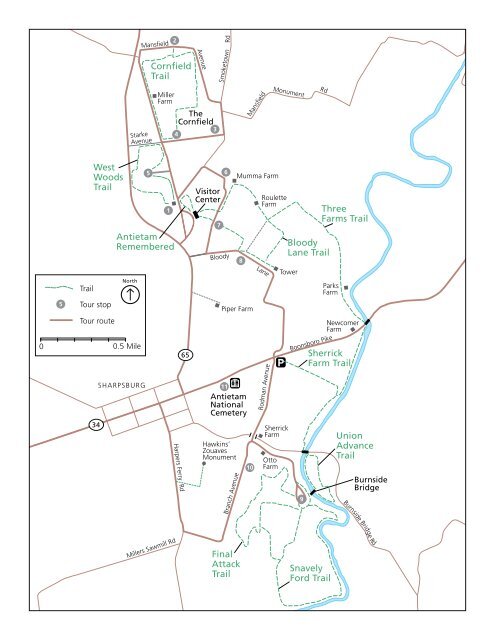
Antietam Bloody Lane, Sharpsburg MD<br />
Length Difficulty Streams Views Solitude Camping<br />
4.6 mls N/A<br />
<strong>Hiking</strong> Time:<br />
Elev. Gain:<br />
Parking:<br />
3.0 hours plus a half hour for lunch<br />
230 ft<br />
Parking on Rodman Ave and Boonsboro Pike/US34<br />
On September 17, 1862, at what is now the Antietam National Battlefield near Sharpsburg MD, Union and<br />
Confederate armies fought each resulting in over 23,000 casualties. There were three primary engagements<br />
that day that would become know as The Cornfield, Bloody Lane, and The Burnside or Lower Bridge.<br />
The Bloody Lane loop hike is the sister hike to the Burnside Bridge hike, and starts at the same parking<br />
area on Rodman Ave. This loop is the northern loop where you walk along Bloody Lane, pass the visitor<br />
center, and return along Antietam Creek.<br />
Mile 0.0 – Park at the small pullout on Rodman Ave and intersection of US34/Boonsboro Pike. Cross<br />
over US34/Boonsboro Pike and follow paved Rodman Ave for the first 0.7 miles to the Observation<br />
Tower.<br />
Mile 0.7 - From the top of the Observation Tower you have a panoramic view of the entire northern<br />
Antietam Battlefield, with the view to the northwest looking directly up Bloody Lane and the Antietam<br />
Battlefield visitor center in the distance.<br />
Mile 0.7 - Walk down Bloody Lane for 0.3 miles. Where the Bloody Lane Trail meets back with the<br />
road it will turn right in to the field for 0.1 miles before turning left towards the Visitor Center.<br />
Shortly crossing a road and climb the small hill to the Visitor Center.<br />
Mile 1.6 - Head back down the field you just climbed to the Visitor Center and now turn left on the<br />
small paved road you just crossed. Follow the road down to Mumma Farm.<br />
Mile 1.9 - Turn right at the information kiosk and Three Farms Trail as it descends a passes around<br />
the Roulette Farm. Continue down the trail for another 0.2 miles and reach the intersection of the<br />
Bloody Lane Trail.<br />
Mile 2.1 - Turn left remaining on the Three Farms Trail as it passes two fields then bears right going<br />
through a wooded area and crossing a ridge. The trail will reach Antietam Creek and pass underneath<br />
US34 in 1.6 miles from the Bloody Lane intersection.<br />
Mile 3.7 - Continue to follow The Three Ridges Trail for another 0.5 miles to the intersection of the<br />
Sherrick Farm Trail.<br />
Mile 4.1 - Turn right uphill on the Sherrick Farm Trail and pass two fields for the remaining 0.5 miles<br />
back to the parking area.<br />
Mile 4.6 - Arrive back at the parking area on US34/Boonsboro Pike.<br />
www.hikingupward.com