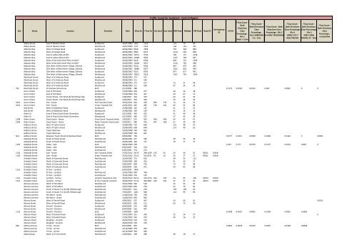
Traffic Count for Auckland - Central Region - Auckland Transport
Traffic Count for Auckland - Central Region - Auckland Transport
Traffic Count for Auckland - Central Region - Auckland Transport

You also want an ePaper? Increase the reach of your titles
YUMPU automatically turns print PDFs into web optimized ePapers that Google loves.
<strong>Traffic</strong> <strong>Count</strong> <strong>for</strong> <strong>Auckland</strong> - <strong>Central</strong> <strong>Region</strong><br />
Site Street Location Direction Date 5Day Av 7 Day Av Sat total Sun total AM Peak Midday PM Peak Road ID Carriageway<br />
ID<br />
HCV%<br />
7 Day <strong>Count</strong> -<br />
Both<br />
Directions<br />
Class<br />
Percentage -<br />
Bin 1<br />
Short < 5.5m<br />
7 Day <strong>Count</strong> -<br />
Both Directions<br />
Class<br />
Percentage -<br />
Bin 2 MEDIUM<br />
5.5 - 11m<br />
7 Day <strong>Count</strong> - Both<br />
Directions Class<br />
Percentage - Bin 3<br />
2-4 AXLE TRUCK/BUS<br />
7 Day <strong>Count</strong> -<br />
Both Directions<br />
Class Percentage -<br />
Bin 4<br />
LONG 3 TO 7<br />
AXLE TRUCKS<br />
7 Day <strong>Count</strong> -<br />
Both Directions<br />
Class Percentage<br />
- Bin 5<br />
VERY LONG<br />
TRUCKS 17 - 35m<br />
7 Day <strong>Count</strong> -<br />
Both Directions<br />
Class<br />
Percentage -<br />
unclassified<br />
Abbey Street East of Newton Road Eastbound 15/07/2005 1202 1155 121 79 80<br />
Abbey Street East of Newton Road Westbound 15/07/2005 1737 1545 134 119 201<br />
Abbotts Way West of College Road Eastbound 26/06/2002 8520 7996 755 548 883<br />
Abbotts Way West of College Road Westbound 26/06/2002 9584 8772 1114 594 858<br />
Abbotts Way East of Ladies Mile At #53 Eastbound 18/02/2004 10272 9730 706 737 1158<br />
Abbotts Way East of Ladies Mile At #53 Westbound 18/02/2004 10308 9592 1237 748 847<br />
Abbotts Way West of Kenneth Small Place At #167 Eastbound 22/06/2005 9418 8704 844 712 1039<br />
Abbotts Way West of Kenneth Small Place At #167 Westbound 22/06/2005 10146 9251 1134 720 998<br />
Abbotts Way 20m West of Retirement Village, Ellerslie Eastbound 22/08/2007 9310 8766 867 679 943<br />
Abbotts Way 20m West of Retirement Village, Ellerslie Westbound 22/08/2007 10089 9327 1012 819 944<br />
Abbotts Way 20m West of Retirement Village, Ellerslie Eastbound 29/08/2007 9313 8705 877 677 991<br />
Abbotts Way 20m West of Retirement Village, Ellerslie Westbound 29/08/2007 10012 9216 1017 792 1040<br />
Aberfoyle Street West of St Andrews Road Eastbound 30/08/2003 175 157<br />
Aberfoyle Street West of St Andrews Road Westbound 30/08/2003 211 184<br />
Aberfoyle Street West of St Andrews Road Eastbound 30/08/2003 175 157 13 31 46<br />
Aberfoyle Street West of St Andrews Road Westbound 30/08/2003 211 184 37 24 22<br />
792 Aberfoyle Street St Andrews-Pencarrow Both 2/12/2008 388 0.1272 0.8728 0.0535 0.067 0.0067 0 0<br />
Acorn Street East of Pah Road Eastbound 17/09/2003 393 377 39 36 38<br />
Acorn Street East of Pah Road Westbound 17/09/2003 474 447 33 67 71<br />
Acorn Street Crown Street - Pah Road (At #12) Royal Oak Eastbound 1/06/2007 401 379 64 41 45<br />
Acorn Street Crown Street - Pah Road (At #12) Royal Oak Westbound 1/06/2007 354 338 29 46 50<br />
1016 Acorn Street Pah - Crown Pah Towards Crown 15/02/2011 444 429 409 374 74 34 37<br />
1016 Acorn Street Pah - Crown Crown Towards Pah 15/02/2011 487 485 518 441 65 55 84<br />
Ada Street West of Middleton Road Eastbound 27/08/2001 145 132 41 11 25<br />
Ada Street West of Middleton Road Westbound 27/08/2001 149 139 32 16 23<br />
Adam St East of Great South Road, Greenlane Eastbound 3/12/2006 443 422 31 49 46<br />
Adam St East of Great South Road, Greenlane Westbound 3/12/2006 385 372 37 43 39<br />
1298 Adam Street Great South - Nolan Great South Towards Nolan 1/03/2011 531 503 458 409 56 41 67<br />
1298 Adam Street Great South - Nolan Nolan Towards Great South 1/03/2011 485 476 447 458 51 39 60<br />
Addison Street West of Taylor Street Eastbound 31/08/2002 710 660 151 48 41<br />
Addison Street West of Taylor Street Westbound 31/08/2002 698 648 127 49 61<br />
Addison Street Taylor-Marlowe Eastbound 15/09/2008 764 692<br />
Addison Street Taylor-Marlowe Westbound 15/09/2008 748 681<br />
N/A Addison Street Between Taylor Street & Marlowe Road Both 9/09/2008 756 0.0777 0.9221 0.0309 0.0306 0.0162 0 0.0001<br />
Adelaide Street South of Drake Street Northbound 20/09/2001 217 185 49 24 26<br />
Adelaide Street South of Drake Street Southbound 20/09/2001 183 157 10 17 37<br />
1130 Adelaide Street Drake - Sale both 30/04/2009 599 0.243 0.757 0.0769 0.1357 0.0214 0.009 0<br />
Adelaide Street Drake - Sale Northbound 6/05/2009 324 270<br />
Adelaide Street Drake - Sale Southbound 6/05/2009 274 274<br />
1130 Adelaide Street Sale - Drake Sale Towards Drake 27/02/2012 367.8 288.1429 133 45 43 40 32 30011 15818<br />
1130 Adelaide Street Sale - Drake Drake Towards Sale 27/02/2012 251.6 192.8571 59 33 26 27 27 30011 15818<br />
Airedale Street North of Symonds Street Northbound 21/09/2001 721 620 49 53 112<br />
Airedale Street North of Symonds Street Southbound 21/09/2001 369 323 31 35 57<br />
Airedale Street North of Symonds Street Northbound 3/06/2004 800 716 73 73 98<br />
Airedale Street North of Symonds Street Southbound 3/06/2004 506 471 34 63 68<br />
1131 Airedale Street St Paul - Lyndock both 6/05/2009 1406<br />
Airedale Street St Paul - Lyndock Northbound 12/05/2009 830 760<br />
Airedale Street St Paul - Lyndock Southbound 12/05/2009 576 576<br />
1131 Airedale Street Lyndock - St Paul Lyndock Towards St Paul 19/03/2012 821.6 743.5714 550 547 44 65 106 34974 22019<br />
1131 Airedale Street Lyndock - St Paul St Paul Towards Lyndock 19/03/2012 371.6 369.2857 326 401 27 37 63 34974 22019<br />
Akarana Avenue North of Mt Albert Northbound 15/07/2003 540 518 25 55 64<br />
Akarana Avenue North of Mt Albert Southbound 15/07/2003 805 758 42 76 82<br />
Akarana Avenue South of Quest Tce [At #5] Hillsborough Northbound 7/05/2007 814 760 103 109 64<br />
Akarana Avenue South of Quest Tce [At #5] Hillsborough Southbound 7/05/2007 1021 948 114 99 90<br />
Akarana Avenue Mt Albert - Quest Northbound 11/08/2010 768 708<br />
Akarana Avenue Mt Albert - Quest Southbound 11/08/2010 964 964<br />
Akaroa Street West of Parnell Road Eastbound 4/09/2001 537 447 43 60 61 0.0011<br />
Akaroa Street West of Parnell Road Westbound 4/09/2001 620 511 83 73 50<br />
Akaroa Street Parnell - Cheshire Eastbound 8/04/2009 515 438<br />
Akaroa Street Parnell - Cheshire Westbound 8/04/2009 526 447<br />
1132 Akaroa Street Parnell - Cheshire both 2/04/2009 1041 0.5398 0.4591 0.0602 0.3569 0.0925 0.0302<br />
Alamein Road West of Dunkirk Road Eastbound 17/02/2007 251 246 25 24 27 0<br />
Alamein Road West of Dunkirk Road Westbound 17/02/2007 243 229 44 16 23<br />
Alamein Road Benghazi - Dunkirk Eastbound 29/03/2010 229 216<br />
Alamein Road Benghazi - Dunkirk Westbound 29/03/2010 239 239<br />
940 Albany Avenue Trinity - Jervois Both 8/12/2009 962 0.0922 0.9078 0.0379 0.0397 0.0138 0.0008<br />
Albany Avenue Trinity - Jervois Northbound 14/12/2009 379 350<br />
Albany Avenue Trinity - Jervois Southbound 14/12/2009 583 583<br />
Albany Road North of Trinity Street Northbound 1/06/2001 309 286 40 18 37
<strong>Traffic</strong> <strong>Count</strong> <strong>for</strong> <strong>Auckland</strong> - <strong>Central</strong> <strong>Region</strong><br />
Site Street Location Direction Date 5Day Av 7 Day Av Sat total Sun total AM Peak Midday PM Peak Road ID Carriageway<br />
ID<br />
HCV%<br />
7 Day <strong>Count</strong> -<br />
Both<br />
Directions<br />
Class<br />
Percentage -<br />
Bin 1<br />
Short < 5.5m<br />
7 Day <strong>Count</strong> -<br />
Both Directions<br />
Class<br />
Percentage -<br />
Bin 2 MEDIUM<br />
5.5 - 11m<br />
7 Day <strong>Count</strong> - Both<br />
Directions Class<br />
Percentage - Bin 3<br />
2-4 AXLE TRUCK/BUS<br />
7 Day <strong>Count</strong> -<br />
Both Directions<br />
Class Percentage -<br />
Bin 4<br />
LONG 3 TO 7<br />
AXLE TRUCKS<br />
7 Day <strong>Count</strong> -<br />
Both Directions<br />
Class Percentage<br />
- Bin 5<br />
VERY LONG<br />
TRUCKS 17 - 35m<br />
7 Day <strong>Count</strong> -<br />
Both Directions<br />
Class<br />
Percentage -<br />
unclassified<br />
Albany Road North of Trinity Street Southbound 1/06/2001 385 361 32 33 50<br />
Albert Street South of Wyndham Street Northbound 28/03/2004 7018 6493 595 814 571<br />
Albert Street South of Wyndham Street Southbound 28/03/2004 6502 6192 477 760 495<br />
Albert Street North of Princes Street #11 Northbound 6/10/2004 472 483 63 48 45<br />
Albert Street North of Princes Street #11 Southbound 6/10/2004 578 570 53 55 68<br />
Albert Street North of Wellesley Street Northbound 20/03/2005 7097 6299 624 499 541<br />
Albert Street North of Wellesley Street Southbound 20/03/2005 8554 7516 487 604 786<br />
Albert Street North of Wellesley Street Northbound 16/10/2005 6520 6046 584 454 477<br />
Albert Street North of Wellesley Street Southbound 16/10/2005 7573 7110 478 500 667<br />
Albert Street Wellesley Street - Victoria Street Northbound 9/03/2006 6677 6202 560 470 447 0.0001<br />
Albert Street Wellesley Street - Victoria Street Southbound 9/03/2006 7984 7447 493 541 642<br />
Albert Street Wellesley Street - Victoria Street Northbound 13/10/2006 6136 5683 518 435 469<br />
Albert Street Wellesley Street - Victoria Street Southbound 13/10/2006 7428 6963 497 483 667<br />
1553 Albert Street Princes - Luke Both 11/06/2010 1724 0.1459 0.854 0.0543 0.0724 0.0174 0.0018<br />
1553 Albert Street Princes - Luke Northbound 17/06/2010 813 716<br />
1553 Albert Street Princes - Luke Southbound 17/06/2010 911 911<br />
Alberton Avenue North of Mt Albert Road Northbound 3/07/2002 2136 1993 591 189 186 0.0005<br />
Alberton Avenue North of Mt Albert Road Southbound 3/07/2002 2657 2492 226 232 451<br />
Alberton Avenue 110m South of Mt Albert Grammar Gate [At #52] Mt Albert Northbound 11/06/2006 2433 2296 577 187 216<br />
Alberton Avenue 110m South of Mt Albert Grammar Gate [At #52] Mt Albert Southbound 11/06/2006 2871 2742 227 254 520<br />
624 Alberton Avenue Mt Albert - Lloyd Both 22/08/2009 4886 0.1157 0.8838 0.0296 0.0487 0.0334 0.004<br />
Alberton Avenue Mt Albert - Lloyd Northbound 28/08/2009 2417 2240<br />
Alberton Avenue Mt Albert - Lloyd Southbound 28/08/2009 2780 2780<br />
Albion Road Midblock (At #15) Otahuhu Eastbound 16/06/2007 1814 1563 171 144 163<br />
Albion Road Midblock (At #15) Otahuhu Westbound 16/06/2007 2208 1918 244 187 185<br />
Albury Avenue East of Mountain Road Eastbound 2/09/2003 538 467 108 51 56<br />
Albury Avenue East of Mountain Road Westbound 2/09/2003 1415 1278 150 132 122<br />
1307 Albury Avenue Sharpe - Mountain Sharpe Towards Mountain 17/02/2011 1588 1402 1101 774 178 117 155<br />
1307 Albury Avenue Sharpe - Mountain Mountain Towards Sharpe 17/02/2011 723 603 382 221 108 49 155<br />
Alderly Road South of View Road Northbound 30/04/2003 226 209 48 24 26 0<br />
Alderly Road South of View Road Southbound 30/04/2003 145 141 8 16 37<br />
Alderly Road View-Bellview Northbound 14/11/2008 213 212<br />
Alderly Road View-Bellview Southbound 14/11/2008 183 163<br />
901 Alderly Road View-Bellview Both 8/11/2008 396 0.2082 0.7918 0.1085 0.0902 0.0076 0.0019<br />
Aldred Road West of Spencer Street At #16 Eastbound 3/12/2004 1162 971 278 55 84<br />
Aldred Road West of Spencer Street At #16 Westbound 3/12/2004 1275 1120 122 80 187<br />
Alex Evans Street East of St Benedicts Street Eastbound 25/08/2004 2967 2589 364 212 398 0<br />
Alex Evans Street East of St Benedicts Street Westbound 25/08/2004 5804 5414 402 426 473<br />
Alexis Avenue South of New North Road Northbound 9/07/2002 266 252 26 23 29<br />
Alexis Avenue South of New North Road Southbound 9/07/2002 320 294 13 28 50<br />
625 Alexis Avenue New North - Violet Both 25/08/2009 684 0.0979 0.9021 0.0593 0.0319 0.0067 0<br />
Alexis Avenue New North - Violet Northbound 31/08/2009 429 381<br />
Alexis Avenue New North - Violet Southbound 31/08/2009 320 320<br />
Al<strong>for</strong>d Street West of Great North Road Eastbound 22/05/2002 980 942 159 85 84 0<br />
Al<strong>for</strong>d Street West of Great North Road Westbound 22/05/2002 683 691 38 64 83<br />
Al<strong>for</strong>d Street EAST OF SAXON STREET (at # 37) WATERVIEW Westbound 24/02/2009 455 446<br />
Al<strong>for</strong>d Street EAST OF SAXON STREET (at # 37) WATERVIEW Eastbound 24/02/2009 583 566 0.0013<br />
626 Al<strong>for</strong>d Street Great North - Middlesex Both 2/09/2009 1540 0.0778 0.9222 0.0312 0.0327 0.0122 0.0017<br />
Al<strong>for</strong>d Street Great North - Middlesex Eastbound 8/09/2009 928 911<br />
Al<strong>for</strong>d Street Great North - Middlesex Westbound 8/09/2009 618 618<br />
1136 Alfred Street Princes - Symonds both 6/05/2009 739 0.61 0.3887 0.0686 0.4616 0.0681 0.0117<br />
Alfred Street Princes - Symonds Eastbound 12/05/2009 707 623<br />
Alfred Street Princes - Symonds Westbound 12/05/2009 32 32<br />
1136 Alfred Street Princes - Symonds Princes Towards Symonds 19/03/2012 453.6 400.1429 278 255 36 33 35 30033 15830<br />
1136 Alfred Street Princes - Symonds Symonds Towards Princes 19/03/2012 18.6 16.14286 7 13 1 5 2 30033 15830<br />
Alfred Street City East of Princes Street, One Way Eastbound 4/11/2003 4987 4733 380 405 437<br />
Alfred Street Onehunga North of Neilson Street Northbound 24/10/2002 1228 1044 99 110 109 0.0035<br />
Alfred Street Onehunga North of Neilson Street Southbound 24/10/2002 937 810 90 92 64<br />
Alfred Street Onehunga South of Waikaraka Road Northbound 4/10/2004 411 352 36 39 49<br />
Alfred Street Onehunga South of Waikaraka Road Southbound 4/10/2004 433 371 55 50 44 0.0121<br />
Alfred Street Onehunga North of Heretaunga Avenue At #83 Northbound 12/05/2005 1366 1277 131 112 156<br />
Alfred Street Onehunga North of Heretaunga Avenue At #83 Southbound 12/05/2005 1098 1042 97 86 130<br />
1010 Alfred Street Onehunga Waikaraka - Alfred End Both 14/10/2009 557 0.1999 0.7965 0.1099 0.0695 0.0151 0.0054 0.0001<br />
Alfred Street Onehunga Waikaraka - Alfred End Northbound 20/10/2009 276 221<br />
Alfred Street Onehunga Waikaraka - Alfred End Southbound 20/10/2009 281 281<br />
1009 Alfred Street Onehunga Neilson - Bond Both 26/10/2009 1369 0.2192 0.7687 0.0821 0.0848 0.0389 0.0134<br />
Ali<strong>for</strong>d Avenue South of Ewenson Avenue Northbound 28/01/2004 570 546 91 41 44<br />
Ali<strong>for</strong>d Avenue South of Ewenson Avenue Southbound 28/01/2004 702 651 47 52 129 0<br />
902 Ali<strong>for</strong>d Avenue Ewenson - Titahi Both 6/11/2009 1385 0.1094 0.8905 0.0429 0.0444 0.0161 0.006
<strong>Traffic</strong> <strong>Count</strong> <strong>for</strong> <strong>Auckland</strong> - <strong>Central</strong> <strong>Region</strong><br />
Site Street Location Direction Date 5Day Av 7 Day Av Sat total Sun total AM Peak Midday PM Peak Road ID Carriageway<br />
ID<br />
HCV%<br />
7 Day <strong>Count</strong> -<br />
Both<br />
Directions<br />
Class<br />
Percentage -<br />
Bin 1<br />
Short < 5.5m<br />
7 Day <strong>Count</strong> -<br />
Both Directions<br />
Class<br />
Percentage -<br />
Bin 2 MEDIUM<br />
5.5 - 11m<br />
7 Day <strong>Count</strong> - Both<br />
Directions Class<br />
Percentage - Bin 3<br />
2-4 AXLE TRUCK/BUS<br />
7 Day <strong>Count</strong> -<br />
Both Directions<br />
Class Percentage -<br />
Bin 4<br />
LONG 3 TO 7<br />
AXLE TRUCKS<br />
7 Day <strong>Count</strong> -<br />
Both Directions<br />
Class Percentage<br />
- Bin 5<br />
VERY LONG<br />
TRUCKS 17 - 35m<br />
7 Day <strong>Count</strong> -<br />
Both Directions<br />
Class<br />
Percentage -<br />
unclassified<br />
Allendale Road West of Mt Albert Road Eastbound 16/07/2002 1325 1313 267 144 109<br />
Allendale Road West of Mt Albert Road Westbound 16/07/2002 1359 1349 68 116 232<br />
Allendale Road South of Stilwell Road At #19 Northbound 6/06/2006 1501 1381 328 160 112<br />
Allendale Road South of Stilwell Road At #19 Southbound 6/06/2006 1432 1339 75 108 246<br />
627 Allendale Road Stilwell - Mount Albert Both 1/09/2009 2929 0.0688 0.9312 0.0218 0.0265 0.0198 0.0007<br />
Allendale Road Stilwell - Mount Albert Northbound 7/09/2009 1602 1479<br />
Allendale Road Stilwell - Mount Albert Southbound 7/09/2009 1566 1566<br />
Allum Street North of Kohimarama Road Northbound 4/06/2003 1730 1629 123 133 208 0<br />
Allum Street North of Kohimarama Road Southbound 4/06/2003 1896 1781 263 171 206<br />
Allum Street North of Baddeley Avenue At #50 Northbound 13/04/2006 2047 1992 153 179 229<br />
Allum Street North of Baddeley Avenue At #50 Southbound 13/04/2006 2031 1935 203 165 187 0.0014<br />
Allum Street North of St Thomas School At #120 Northbound 28/05/2006 1922 1906 163 217 231<br />
Allum Street North of St Thomas School At #120 Southbound 28/05/2006 2154 2066 318 164 168<br />
1414 Allum Street Melanesia - Towai both 3/06/2009 2782 0.0571 0.9429 0.0229 0.0158 0.0176 0.0007<br />
Allum Street Melanesia - Towai Northbound 9/06/2009 1439 1375<br />
Allum Street Melanesia - Towai Southbound 9/06/2009 1343 1343<br />
291 Allum Street Kohimarama - Hopkins Both 3/05/2010 3859 0.1432 0.8554 0.0365 0.0665 0.034 0.0061<br />
Allum Street Kohimarama - Hopkins Northbound 3/05/2010 1861 1836 0<br />
Allum Street Kohimarama - Hopkins Southbound 3/05/2010 1998 1998<br />
Almond Place South of Harwood Road At #7 Northbound 16/04/2006 613 569 57 46 79 0.0031<br />
Almond Place South of Harwood Road At #7 Southbound 16/04/2006 491 463 53 38 52<br />
Almorah Road At #21 Almorah Road Northbound 26/08/2001 259 218 44 32 17 0.0029<br />
Almorah Road At #21 Almorah Road Southbound 26/08/2001 320 273 43 27 37<br />
1282 Almorah Road Gilgit - Mountain Both 15/03/2010 583 0.1112 0.8888 0.0448 0.0558 0.0101 0.0005<br />
Alpers Avenue West of Manukau Road, Oneway Westbound 9/08/2002 12816 12180 853 987 1033<br />
204 Alpers Avenue Gillies Ave - Broadway Both 12/03/2009 11578 0.1828 0.8141 0.0624 0.0451 0.065 0.0104<br />
Alpers Avenue Gillies Ave - Broadway Eastbound 18/03/2009 11170 11007<br />
204 Alpers Avenue Gillies - Broadway Both 16/03/2010 11726 0.189 0.8081 0.038 0.0597 0.0813 0.01<br />
Alten Road East of Symonds Street Eastbound 23/05/2002 9346 8553<br />
Alten Road East of Symonds Street Westbound 23/05/2002 965 877<br />
Alten Road East of Symonds Street Eastbound 23/05/2002 9346 8553 538 806 822<br />
Alten Road East of Symonds Street Westbound 23/05/2002 965 877 103 82 88<br />
Alten Road West of Churchill Street Eastbound 8/11/2003 8631 7951<br />
Alten Road West of Churchill Street Westbound 8/11/2003 5941 5081<br />
Alten Road West of Churchill Street Eastbound 8/11/2003 8631 7951 507 609 734<br />
Alten Road West of Churchill Street Westbound 8/11/2003 5941 5081 872 369 362<br />
Alten Road East of Symonds Street Eastbound 24/10/2004 8679 7651<br />
Alten Road East of Symonds Street Westbound 24/10/2004 3648 3024<br />
Alten Road East of Symonds Street Eastbound 24/10/2004 8679 7651 502 601 712<br />
Alten Road East of Symonds Street Westbound 24/10/2004 3648 3024 562 264 330<br />
Alten Road East of Symonds Street Eastbound 9/11/2006 7855 7059<br />
Alten Road East of Symonds Street Westbound 9/11/2006 4054 3534<br />
Alten Road East of Symonds Street Eastbound 9/11/2006 7855 7059 508 569 643<br />
Alten Road East of Symonds Street Westbound 9/11/2006 4054 3534 542 283 319<br />
Alten Road East of Symonds Street, CBD Eastbound 14/09/2007 8042 7221<br />
Alten Road East of Symonds Street, CBD Westbound 14/09/2007 4212 3644<br />
Alten Road East of Symonds Street, CBD Eastbound 14/09/2007 8042 7221 460 561 597 0.006<br />
Alten Road East of Symonds Street, CBD Westbound 14/09/2007 4212 3644 575 257 318<br />
Alten Road East of Symonds Street, CBD Eastbound 21/09/2007 8031 7226<br />
Alten Road East of Symonds Street, CBD Westbound 21/09/2007 4236 3647 0.0071<br />
Alten Road East of Symonds Street, CBD Eastbound 21/09/2007 8031 7226 460 573 568<br />
Alten Road East of Symonds Street, CBD Westbound 21/09/2007 4236 3647 552 282 334<br />
60 Alten Road Symonds-Churchill both 2/04/2009 9801 0.2536 0.7404 0.0371 0.0868 0.1095 0.0203<br />
Alten Road Symonds-Churchill Northbound 8/04/2009 3233 2847<br />
Alten Road Symonds-Churchill Southbound 8/04/2009 6568 6108 0.0001<br />
60 Alten Road Symonds - Churchill Both 5/03/2010 9915 0.2547 0.7382 0.039 0.076 0.1197 0.02<br />
Altham Avenue West of Sandringham Road Eastbound 15/02/2003 794 693<br />
Altham Avenue West of Sandringham Road Westbound 15/02/2003 636 561<br />
Altham Avenue West of Sandringham Road Eastbound 15/02/2003 794 693 133 63 61<br />
Altham Avenue West of Sandringham Road Westbound 15/02/2003 636 561 51 59 88<br />
628 Altham Avenue Sandringham - Rossmay Both 21/08/2009 1715 0.136 0.864 0.0639 0.0531 0.0174 0.0015<br />
Altham Avenue Sandringham - Rossmay Eastbound 27/08/2009 1112 963 0<br />
Altham Avenue Sandringham - Rossmay Westbound 27/08/2009 873 873<br />
Alverston Road East of Middlesex Road Eastbound 24/05/2002 353 365<br />
Alverston Road East of Middlesex Road Westbound 24/05/2002 404 417<br />
Alverston Road East of Middlesex Road Eastbound 24/05/2002 353 365 30 41 33<br />
Alverston Road East of Middlesex Road Westbound 24/05/2002 404 417 13 44 49<br />
629 Alverston Road Middlesex - Great North Both 8/09/2009 877 0.0679 0.9321 0.0179 0.043 0.0067 0.0003<br />
Alverston Road Middlesex - Great North Eastbound 14/09/2009 389 394
<strong>Traffic</strong> <strong>Count</strong> <strong>for</strong> <strong>Auckland</strong> - <strong>Central</strong> <strong>Region</strong><br />
Site Street Location Direction Date 5Day Av 7 Day Av Sat total Sun total AM Peak Midday PM Peak Road ID Carriageway<br />
ID<br />
HCV%<br />
7 Day <strong>Count</strong> -<br />
Both<br />
Directions<br />
Class<br />
Percentage -<br />
Bin 1<br />
Short < 5.5m<br />
7 Day <strong>Count</strong> -<br />
Both Directions<br />
Class<br />
Percentage -<br />
Bin 2 MEDIUM<br />
5.5 - 11m<br />
7 Day <strong>Count</strong> - Both<br />
Directions Class<br />
Percentage - Bin 3<br />
2-4 AXLE TRUCK/BUS<br />
7 Day <strong>Count</strong> -<br />
Both Directions<br />
Class Percentage -<br />
Bin 4<br />
LONG 3 TO 7<br />
AXLE TRUCKS<br />
7 Day <strong>Count</strong> -<br />
Both Directions<br />
Class Percentage<br />
- Bin 5<br />
VERY LONG<br />
TRUCKS 17 - 35m<br />
7 Day <strong>Count</strong> -<br />
Both Directions<br />
Class<br />
Percentage -<br />
unclassified<br />
Alverston Road Middlesex - Great North Westbound 14/09/2009 479 479<br />
Amaru Road West of Mariri Road At #10 Eastbound 13/12/2003 476 474<br />
Amaru Road West of Mariri Road At #10 Westbound 13/12/2003 331 324<br />
Amaru Road West of Mariri Road At #10 Eastbound 13/12/2003 476 474 37 57 86<br />
Amaru Road West of Mariri Road At #10 Westbound 13/12/2003 331 324 29 28 57<br />
Ambury Avenue East of Pah Road Eastbound 9/09/2003 142 141<br />
Ambury Avenue East of Pah Road Westbound 9/09/2003 139 136<br />
Ambury Avenue East of Pah Road Eastbound 9/09/2003 142 141 16 23 18<br />
Ambury Avenue East of Pah Road Westbound 9/09/2003 139 136 21 15 17<br />
Anderson Avenue West of Tamatea Avenue At #49 Eastbound 16/02/2006 179 179<br />
Anderson Avenue West of Tamatea Avenue At #49 Westbound 16/02/2006 198 201<br />
Anderson Avenue West of Tamatea Avenue At #49 Eastbound 16/02/2006 179 179 12 17 20<br />
Anderson Avenue West of Tamatea Avenue At #49 Westbound 16/02/2006 198 201 20 22 21<br />
Anderson Avenue Kawiti - Tamatea Eastbound 21/03/2010 132 131 0.0014<br />
Anderson Avenue Kawiti - Tamatea Westbound 21/03/2010 169 169<br />
Angle Street South of Neilson Street At #6 Northbound 2/10/2004 1357 1068<br />
Angle Street South of Neilson Street At #6 Southbound 2/10/2004 1438 1128<br />
Angle Street South of Neilson Street At #6 Northbound 2/10/2004 1357 1068 93 139 166<br />
Angle Street South of Neilson Street At #6 Southbound 2/10/2004 1438 1128 182 130 82<br />
1000 Angle Street Neilson - Miami Parade Both 26/10/2009 2030 0.2622 0.7364 0.1273 0.0886 0.0359 0.0104<br />
Anglesea Street East of Ponsonby Road Eastbound 1/06/2001 509 503<br />
Anglesea Street East of Ponsonby Road Westbound 1/06/2001 309 301<br />
Anglesea Street East of Ponsonby Road Eastbound 1/06/2001 509 503 61 51 41 0<br />
Anglesea Street East of Ponsonby Road Westbound 1/06/2001 309 301 26 25 33<br />
Anglesea Street West of Heke Street At #18/East of Ponsonby Road Eastbound 30/04/2006 684 662<br />
Anglesea Street West of Heke Street At #18/East of Ponsonby Road Westbound 30/04/2006 450 440<br />
Anglesea Street West of Heke Street At #18/East of Ponsonby Road Eastbound 30/04/2006 684 662 86 64 72<br />
Anglesea Street West of Heke Street At #18/East of Ponsonby Road Westbound 30/04/2006 450 440 47 50 44<br />
1137 Anglesea Street Winn - Hepburn Both 1/03/2009 822 0.0748 0.9252 0.053 0.0141 0.0077 0<br />
Anglesea Street Winn - Hepburn Eastbound 5/03/2009 508 492<br />
Anglesea Street Winn - Hepburn Westbound 5/03/2009 314 308<br />
1137 Anglesea Street Winn - Hepburn Winn Towards Hepburn 27/02/2012 452.2 437 433 365 63 39 38 30047 15836<br />
1137 Anglesea Street Winn - Hepburn Hepburn Towards Winn 27/02/2012 337.6 320.4286 302 253 40 33 30 30047 15836<br />
Anzac Avenue 150m North of Alten Road Northbound 21/11/2004 8132 7575 0<br />
Anzac Avenue 150m North of Alten Road Southbound 21/11/2004 6765 6209<br />
Anzac Avenue 150m North of Alten Road Northbound 21/11/2004 8132 7575 682 528 660<br />
Anzac Avenue 150m North of Alten Road Southbound 21/11/2004 6765 6209 449 462 515<br />
Aotea Street North of Rukutai Street Northbound 22/06/2004 909 880<br />
Aotea Street North of Rukutai Street Southbound 22/06/2004 1545 1325<br />
Aotea Street North of Rukutai Street Northbound 22/06/2004 909 880 67 67 161<br />
Aotea Street North of Rukutai Street Southbound 22/06/2004 1545 1325 551 60 72<br />
1415 Aotea Street Nihill - Rukutai both 11/06/2009 2130 0.0635 0.9365 0.0335 0.0189 0.0111 0<br />
Aotea Street Nihill - Rukutai Northbound 17/06/2009 834 774 0<br />
Aotea Street Nihill - Rukutai Southbound 17/06/2009 1295 1295<br />
Apihai Street South of Reihana Street At #15 Northbound 20/07/2005 79 74<br />
Apihai Street South of Reihana Street At #15 Southbound 20/07/2005 80 73<br />
Apihai Street South of Reihana Street At #15 Northbound 20/07/2005 79 74 9 10 8<br />
Apihai Street South of Reihana Street At #15 Southbound 20/07/2005 80 73 8 16 10<br />
Apihai Street Tautari - Reihana Northbound 2/07/2009 75 73<br />
Apihai Street Tautari - Reihana Southbound 2/07/2009 78 78<br />
1416 Apihai Street Tautari - Reihana Both 26/07/2009 153 0.1437 0.8563 0.1142 0.0276 0.0019<br />
Apirana Avenue North of Taniwha Street Northbound 26/08/2001 7734 7380<br />
Apirana Avenue North of Taniwha Street Southbound 26/08/2001 7616 7383<br />
Apirana Avenue North of Taniwha Street Northbound 26/08/2001 7734 7380 745 721 742<br />
Apirana Avenue North of Taniwha Street Southbound 26/08/2001 7616 7383 637 737 752<br />
Apirana Avenue North of Taniwha Street At #111 Northbound 27/06/2004 7172 6815 0.0135<br />
Apirana Avenue North of Taniwha Street At #111 Southbound 27/06/2004 6297 6093 0.0109<br />
Apirana Avenue North of Taniwha Street At #111 Northbound 27/06/2004 7172 6815 642 641 771<br />
Apirana Avenue North of Taniwha Street At #111 Southbound 27/06/2004 6297 6093 513 547 683<br />
Apirana Avenue Omaru - Taniwha Northbound 22/05/2009 6888 6582<br />
Apirana Avenue Omaru - Taniwha Southbound 22/05/2009 6092 6092<br />
Apirana Avenue Omaru - Taniwha Northbound 21/05/2010 6881 6598<br />
Apirana Avenue Omaru - Taniwha Southbound 21/05/2010 6035 6035<br />
123 Apirana Avenue Omaru - Taniwha both 16/05/2009 12980 0.3849 0.6017 0.0755 0.1451 0.1325 0.0317<br />
123 Apirana Avenue Omaru - Taniwha Both 21/05/2010 12916 0.3883 0.6007 0.0704 0.1628 0.1295 0.0257<br />
Appleyard Crescent Midway At #15 Meadowbank Eastbound 23/01/2006 100 96<br />
Appleyard Crescent Midway At #15 Meadowbank Westbound 23/01/2006 112 109<br />
Appleyard Crescent Midway At #15 Meadowbank Eastbound 23/01/2006 100 96 10 12 10 0.0002<br />
Appleyard Crescent Midway At #15 Meadowbank Westbound 23/01/2006 112 109 7 13 18
<strong>Traffic</strong> <strong>Count</strong> <strong>for</strong> <strong>Auckland</strong> - <strong>Central</strong> <strong>Region</strong><br />
Site Street Location Direction Date 5Day Av 7 Day Av Sat total Sun total AM Peak Midday PM Peak Road ID Carriageway<br />
ID<br />
HCV%<br />
7 Day <strong>Count</strong> -<br />
Both<br />
Directions<br />
Class<br />
Percentage -<br />
Bin 1<br />
Short < 5.5m<br />
7 Day <strong>Count</strong> -<br />
Both Directions<br />
Class<br />
Percentage -<br />
Bin 2 MEDIUM<br />
5.5 - 11m<br />
7 Day <strong>Count</strong> - Both<br />
Directions Class<br />
Percentage - Bin 3<br />
2-4 AXLE TRUCK/BUS<br />
7 Day <strong>Count</strong> -<br />
Both Directions<br />
Class Percentage -<br />
Bin 4<br />
LONG 3 TO 7<br />
AXLE TRUCKS<br />
7 Day <strong>Count</strong> -<br />
Both Directions<br />
Class Percentage<br />
- Bin 5<br />
VERY LONG<br />
TRUCKS 17 - 35m<br />
7 Day <strong>Count</strong> -<br />
Both Directions<br />
Class<br />
Percentage -<br />
unclassified<br />
Appleyard Crescent Fancourt -Temple Eastbound 28/05/2009 129 122<br />
Appleyard Crescent Fancourt -Temple Westbound 28/05/2009 93 93<br />
Arabi Street South of Balmoral Road Northbound 15/01/2003 716 721<br />
Arabi Street South of Balmoral Road Southbound 15/01/2003 708 725<br />
Arabi Street South of Balmoral Road Northbound 15/01/2003 716 721 107 52 64<br />
Arabi Street South of Balmoral Road Southbound 15/01/2003 708 725 35 79 102 0<br />
596 Arabi Street Patterson - Jason Both 14/08/2009 1226 0.2282 0.7716 0.0607 0.1508 0.0139 0.0028<br />
Arabi Street Patterson - Jason Northbound 20/08/2009 673 654<br />
Arabi Street Patterson - Jason Southbound 20/08/2009 569 569<br />
Aragon Avenue Mid Point At #12 Glendowe Eastbound 16/02/2006 109 103<br />
Aragon Avenue Mid Point At #12 Glendowe Westbound 16/02/2006 81 78<br />
Aragon Avenue Mid Point At #12 Glendowe Eastbound 16/02/2006 109 103 11 12 15<br />
Aragon Avenue Mid Point At #12 Glendowe Westbound 16/02/2006 81 78 13 10 10<br />
1474 Aragon Avenue Washington - Crossfield Both 25/06/2010 178 0.2293 0.7707 0.1014 0.1223 0.0032 0.0024<br />
Aragon Avenue Washington - Crossfield Eastbound 1/07/2010 113 109<br />
Aragon Avenue Washington - Crossfield Westbound 1/07/2010 65 65<br />
Aratonga Avenue Southof Great South Road Northbound 2/10/2003 985 908<br />
Aratonga Avenue Southof Great South Road Southbound 2/10/2003 1100 1018<br />
Aratonga Avenue Southof Great South Road Northbound 2/10/2003 985 908 127 84 92 0<br />
Aratonga Avenue Southof Great South Road Southbound 2/10/2003 1100 1018 71 85 169<br />
1337 Aratonga Avenue Great South - Korau Great South Towards Korau 1/03/2011 1244 1069 690 572 180 70 137<br />
1337 Aratonga Avenue Great South - Korau Korau Towards Great South 1/03/2011 1040 932 735 590 153 65 99<br />
Arcadia Road East of The Drive, Epsom Eastbound 16/08/2003 321 286<br />
Arcadia Road East of The Drive, Epsom Westbound 16/08/2003 397 370 0<br />
Arcadia Road East of The Drive, Epsom Eastbound 16/08/2003 321 286 54 28 48<br />
Arcadia Road East of The Drive, Epsom Westbound 16/08/2003 397 370 21 40 45<br />
793 Arcadia Road The Drive-Manukau Both 4/12/2008 638 0.1105 0.8895 0.0488 0.0462 0.0152 0.0002<br />
Archdall Street West of Houghton Street At #22 Eastbound 28/07/2005 258 245<br />
Archdall Street West of Houghton Street At #22 Westbound 28/07/2005 259 251<br />
Archdall Street West of Houghton Street At #22 Eastbound 28/07/2005 258 245 17 28 36<br />
Archdall Street West of Houghton Street At #22 Westbound 28/07/2005 259 251 33 27 24 0<br />
1386 Archdall Street Beere - Houghton both 30/05/2009 500 0.0664 0.9336 0.0571 0.0084 0.0009 0<br />
Archdall Street Beere - Houghton Eastbound 5/06/2009 250 235<br />
Archdall Street Beere - Houghton Westbound 5/06/2009 249 249<br />
Ardmore Road North of Pompallier Tce At #31 Northbound 17/11/2004 659 617<br />
Ardmore Road North of Pompallier Tce At #31 Southbound 17/11/2004 682 636<br />
Ardmore Road North of Pompallier Tce At #31 Northbound 17/11/2004 659 617 46 53 75<br />
Ardmore Road North of Pompallier Tce At #31 Southbound 17/11/2004 682 636 65 60 80<br />
941 Ardmore Road Jervois - Pompalier Both 1/12/2009 1418 0.1698 0.8302 0.0583 0.0955 0.0137 0.0023<br />
Ardmore Road Jervois - Pompalier Northbound 7/12/2009 723 666<br />
Ardmore Road Jervois - Pompalier Southbound 7/12/2009 695 695<br />
Argyle Street West of Morningside Drive Eastbound 8/02/2003 293 228<br />
Argyle Street West of Morningside Drive Westbound 8/02/2003 334 262<br />
Argyle Street West of Morningside Drive Eastbound 8/02/2003 293 228 33 52 45 0<br />
Argyle Street West of Morningside Drive Westbound 8/02/2003 334 262 45 50 42<br />
Argyle Street West of Clifton Road At #53 Eastbound 19/11/2004 625 599<br />
Argyle Street West of Clifton Road At #53 Westbound 19/11/2004 627 616<br />
Argyle Street West of Clifton Road At #53 Eastbound 19/11/2004 625 599 101 47 54<br />
Argyle Street West of Clifton Road At #53 Westbound 19/11/2004 627 616 40 63 73<br />
Argyle Street Morningside - Gordon Eastbound 21/08/2009 313 242<br />
Argyle Street Morningside - Gordon Westbound 21/08/2009 313 313<br />
942 Argyle Street Masons - Clifton Both 2/12/2009 1093 0.0843 0.9157 0.0487 0.0277 0.0072 0.0007<br />
Argyle Street Masons - Clifton Eastbound 8/12/2009 555 544<br />
Argyle Street Masons - Clifton Westbound 8/12/2009 538 538<br />
Armadale Road South of Dromorne Road At #12 Northbound 12/11/2004 623 567<br />
Armadale Road South of Dromorne Road At #12 Southbound 12/11/2004 950 845<br />
Armadale Road South of Dromorne Road At #12 Northbound 12/11/2004 623 567 108 41 49 0<br />
Armadale Road South of Dromorne Road At #12 Southbound 12/11/2004 950 845 108 67 107<br />
Armagh Road South of Kinross Street Northbound 27/08/2002 394 381<br />
Armagh Road South of Kinross Street Southbound 27/08/2002 323 301<br />
Armagh Road South of Kinross Street Northbound 27/08/2002 394 381 51 35 48<br />
Armagh Road South of Kinross Street Southbound 27/08/2002 323 301 80 28 26<br />
Armagh Road Kinross-Gilfillan Eastbound 17/10/2008 307 278<br />
Armagh Road Kinross-Gilfillan Westbound 17/10/2008 382 375<br />
558 Armagh Road Kinross-Gilfillan Both 13/10/2008 689 0.0758 0.9242 0.0297 0.0387 0.0072 0.0002<br />
Arney Road South of Arney Cres At #77 Northbound 12/11/2004 1044 978<br />
Arney Road South of Arney Cres At #77 Southbound 12/11/2004 926 872<br />
Arney Road South of Arney Cres At #77 Northbound 12/11/2004 1044 978 101 86 90<br />
Arney Road South of Arney Cres At #77 Southbound 12/11/2004 926 872 81 79 96
<strong>Traffic</strong> <strong>Count</strong> <strong>for</strong> <strong>Auckland</strong> - <strong>Central</strong> <strong>Region</strong><br />
Site Street Location Direction Date 5Day Av 7 Day Av Sat total Sun total AM Peak Midday PM Peak Road ID Carriageway<br />
ID<br />
HCV%<br />
7 Day <strong>Count</strong> -<br />
Both<br />
Directions<br />
Class<br />
Percentage -<br />
Bin 1<br />
Short < 5.5m<br />
7 Day <strong>Count</strong> -<br />
Both Directions<br />
Class<br />
Percentage -<br />
Bin 2 MEDIUM<br />
5.5 - 11m<br />
7 Day <strong>Count</strong> - Both<br />
Directions Class<br />
Percentage - Bin 3<br />
2-4 AXLE TRUCK/BUS<br />
7 Day <strong>Count</strong> -<br />
Both Directions<br />
Class Percentage -<br />
Bin 4<br />
LONG 3 TO 7<br />
AXLE TRUCKS<br />
7 Day <strong>Count</strong> -<br />
Both Directions<br />
Class Percentage<br />
- Bin 5<br />
VERY LONG<br />
TRUCKS 17 - 35m<br />
7 Day <strong>Count</strong> -<br />
Both Directions<br />
Class<br />
Percentage -<br />
unclassified<br />
Arnold Street South of Cockburn Street At #18 Northbound 19/02/2004 267 257 0<br />
Arnold Street South of Cockburn Street At #18 Southbound 19/02/2004 210 196<br />
Arnold Street South of Cockburn Street At #18 Northbound 19/02/2004 267 257 24 31 34<br />
Arnold Street South of Cockburn Street At #18 Southbound 19/02/2004 210 196 27 17 25 0.0002<br />
Aroha Avenue West of Sandringham Road Eastbound 14/02/2003 408 402<br />
Aroha Avenue West of Sandringham Road Westbound 14/02/2003 449 434<br />
Aroha Avenue West of Sandringham Road Eastbound 14/02/2003 408 402 30 36 37<br />
Aroha Avenue West of Sandringham Road Westbound 14/02/2003 449 434 50 39 66<br />
631 Aroha Avenue Sandringham - Bournemouth Both 30/07/2009 1166 0.2348 0.7652 0.0467 0.1704 0.0143 0.0033<br />
Aroha Avenue Sandringham - Bournemouth Eastbound 5/08/2009 545 552<br />
Aroha Avenue Sandringham - Bournemouth Westbound 5/08/2009 626 626<br />
265 Arthur St Selwyn - Gerard Beeson Both 13/10/2009 5238 0.1646 0.8352 0.0598 0.061 0.0413 0.0024<br />
Arthur Street East of Selwyn St Onehunga Eastbound 29/03/2003 2337 2125<br />
Arthur Street East of Selwyn St Onehunga Westbound 29/03/2003 3444 3190<br />
Arthur Street East of Selwyn St Onehunga Eastbound 29/03/2003 2337 2125 339 185 273<br />
Arthur Street East of Selwyn St Onehunga Westbound 29/03/2003 3444 3190 253 329 484<br />
Arthur Street West of Qaudrant Road Onehunga Eastbound 19/11/2003 1571 1398<br />
Arthur Street West of Qaudrant Road Onehunga Westbound 19/11/2003 1433 1330<br />
Arthur Street West of Qaudrant Road Onehunga Eastbound 19/11/2003 1571 1398 248 124 121<br />
Arthur Street West of Qaudrant Road Onehunga Westbound 19/11/2003 1433 1330 109 132 251<br />
Arthur Street West of Symonds Street Onehunga Eastbound 17/05/2005 1844 1626<br />
Arthur Street West of Symonds Street Onehunga Westbound 17/05/2005 1498 1398<br />
Arthur Street West of Symonds Street Onehunga Eastbound 17/05/2005 1844 1626 374 126 160<br />
Arthur Street West of Symonds Street Onehunga Westbound 17/05/2005 1498 1398 179 116 169<br />
Arthur Street West of Onehunga Primary School Eastbound 26/05/2006 2392 2167<br />
Arthur Street West of Onehunga Primary School Westbound 26/05/2006 3440 3194<br />
Arthur Street West of Onehunga Primary School Eastbound 26/05/2006 2392 2167 370 186 199<br />
Arthur Street West of Onehunga Primary School Westbound 26/05/2006 3440 3194 287 316 423<br />
Arthur Street Onehunga Mall- Galway St Eastbound 16/12/2006 4079 3763<br />
Arthur Street Onehunga Mall- Galway St Westbound 16/12/2006 4557 4267<br />
Arthur Street Onehunga Mall- Galway St Eastbound 16/12/2006 4079 3763 374 361 296<br />
Arthur Street Onehunga Mall- Galway St Westbound 16/12/2006 4557 4267 338 455 435<br />
Arthur Street Selwyn - Gerard Beeson Eastbound 19/10/2009 2157 1963<br />
Arthur Street Selwyn - Gerard Beeson Westbound 19/10/2009 3081 3081<br />
Arundel Street West of Rogan Street At #33 Eastbound 14/05/2005 1159 1199<br />
Arundel Street West of Rogan Street At #33 Westbound 14/05/2005 1151 1191<br />
Arundel Street West of Rogan Street At #33 Eastbound 14/05/2005 1159 1199 170 173 242<br />
Arundel Street West of Rogan Street At #33 Westbound 14/05/2005 1151 1191 363 196 209<br />
Ascot Avenue North of Greenlane Road Northbound 19/06/2003 4575 4386<br />
Ascot Avenue North of Greenlane Road Southbound 19/06/2003 5768 5482<br />
Ascot Avenue North of Greenlane Road Northbound 19/06/2003 4575 4386 286 335 366<br />
Ascot Avenue North of Greenlane Road Southbound 19/06/2003 5768 5482 484 506 463<br />
Ascot Avenue North of Remuera Intermediate At #39 Northbound 14/06/2006 4092 4048 0.0014<br />
Ascot Avenue North of Remuera Intermediate At #39 Southbound 14/06/2006 5614 5488 0.0019<br />
Ascot Avenue North of Remuera Intermediate At #39 Northbound 14/06/2006 4092 4048 287 334 393<br />
Ascot Avenue North of Remuera Intermediate At #39 Southbound 14/06/2006 5614 5488 594 550 430<br />
Ascot Avenue Greenlane East - Cotter Ave Northbound 1/05/2009 4146 3972<br />
Ascot Avenue Greenlane East - Cotter Ave Southbound 1/05/2009 5875 5875<br />
Ascot Avenue Greenlane East - Cotter Ave Northbound 26/04/2010 3911 3839<br />
Ascot Avenue Greenlane East - Cotter Ave Southbound 26/04/2010 5733 5733<br />
89 Ascot Avenue Greenlane East - Cotter Ave both 25/04/2009 10021 0.1759 0.8226 0.0581 0.0515 0.0558 0.0105<br />
89 Ascot Avenue Greenlane East - Cotter Ave Both 26/04/2010 9644 0.1482 0.8499 0.051 0.0365 0.0551 0.0056<br />
89 Ascot Avenue Cotter Ave - Greenlane East Cotter Ave Towards Greenlane 7/03/2011 East 5641 5464 5341 4702 483 403 409<br />
89 Ascot Avenue Cotter Ave - Greenlane East Greenlane East Towards Cotter 7/03/2011 Ave 3923 3877 3766 3757 205 301 385<br />
2 Ash St East of Whau River Both 30/11/2009 39019 0.0501 0.9499 0.0414 0.003 0.0057<br />
2 Ash St East of Whau River Both 7/12/2009 40872 0.0436 0.9564 0.0359 0.0028 0.0048<br />
2 Ash St East of Whau River Both 14/12/2009 40686 0.0456 0.9544 0.0374 0.0027 0.0055<br />
2 Ash St East of Whau River Both 21/12/2009 37251 0.0352 0.9648 0.0305 0.0021 0.0027<br />
2 Ash St East of Whau River Both 28/12/2009 25817 0.0272 0.9728 0.0247 0.0014 0.0011<br />
2 Ash St East of Whau River both 30/03/2009 39844 0.0409 0.9591 0.0351 0.0026 0.0032<br />
2 Ash St East of Whau River both 27/04/2009 38861 0.0465 0.9535 0.0383 0.003 0.0052<br />
2 Ash St East of Whau River Eastbound 9/01/2011 13823 13805 14501 13017 1091 1083 985<br />
2 Ash St East of Whau River Westbound 9/01/2011 13542 13610 13987 13570 666 1150 1430<br />
2 Ash St East of Whau River Eastbound 16/01/2011 17522 16809 15837 14217 1573 1119 1017<br />
2 Ash St East of Whau River Westbound 16/01/2011 16921 16362 15362 14565 753 1230 1848<br />
2 Ash St East of Whau River 23/01/2011 18509 17305 15313 13273 1622 1105 1034<br />
2 Ash St East of Whau River 23/01/2011 17406 16166 14655 11475 779 1337 1953<br />
2 Ash St Ash Extension Towards Whau Bridge Ash Extension Towards Whau Bridge 30/01/2011 19244 17842 14426 14247 1726 1131 1040<br />
2 Ash St Ash Extension - Whau Bridge Whau Bridge Towards Ash Extension 30/01/2011 17812 16807 13884 14702 847 1310 1955
<strong>Traffic</strong> <strong>Count</strong> <strong>for</strong> <strong>Auckland</strong> - <strong>Central</strong> <strong>Region</strong><br />
Site Street Location Direction Date 5Day Av 7 Day Av Sat total Sun total AM Peak Midday PM Peak Road ID Carriageway<br />
ID<br />
HCV%<br />
7 Day <strong>Count</strong> -<br />
Both<br />
Directions<br />
Class<br />
Percentage -<br />
Bin 1<br />
Short < 5.5m<br />
7 Day <strong>Count</strong> -<br />
Both Directions<br />
Class<br />
Percentage -<br />
Bin 2 MEDIUM<br />
5.5 - 11m<br />
7 Day <strong>Count</strong> - Both<br />
Directions Class<br />
Percentage - Bin 3<br />
2-4 AXLE TRUCK/BUS<br />
7 Day <strong>Count</strong> -<br />
Both Directions<br />
Class Percentage -<br />
Bin 4<br />
LONG 3 TO 7<br />
AXLE TRUCKS<br />
7 Day <strong>Count</strong> -<br />
Both Directions<br />
Class Percentage<br />
- Bin 5<br />
VERY LONG<br />
TRUCKS 17 - 35m<br />
7 Day <strong>Count</strong> -<br />
Both Directions<br />
Class<br />
Percentage -<br />
unclassified<br />
2 Ash St Ash Extension - Whau Bridge Ash Extension Towards Whau Bridge 6/02/2011 18061 17555 18174 14405 1899 1166 1026<br />
2 Ash St Ash Extension - Whau Bridge Whau Bridge Towards Ash Extension 6/02/2011 17347 18593 28482 14934 869 1373 1978<br />
2 Ash St Ash Extension - Whau Bridge Ash Extension Towards Whau Bridge 13/02/2011 19907 18864 17400 15114 2037 1130 1099<br />
2 Ash St Ash Extension - Whau Bridge Whau Bridge Towards Ash Extension 13/02/2011 18960 18119 16684 15350 991 1418 2011<br />
2 Ash St Ash Extension - Whau Bridge Ash Extension Towards Whau Bridge 20/02/2011 20093 19001 17713 14829 2080 1150 1065<br />
2 Ash St Ash Extension - Whau Bridge Whau Bridge Towards Ash Extension 20/02/2011 18978 18140 16933 15158 964 1513 1841<br />
2 Ash St Ash Extension - Whau Bridge Ash Extension Towards Whau Bridge 27/02/2011 19821 18822 17689 14960 2127 1164 1069<br />
2 Ash St Ash Extension - Whau Bridge Whau Bridge Towards Ash Extension 27/02/2011 18625 17905 17020 15193 976 1446 1844<br />
2 Ash St Ash Extension - Whau Bridge Ash Extension Towards Whau Bridge 8/01/2012 12507.8 12232.57 11720 11369 650 1122 1302 30074 14378<br />
2 Ash St Ash Extension - Whau Bridge Whau Bridge Towards Ash Extension 8/01/2012 12853.4 12449.29 11795 11083 1001 1043 920 30074 14378<br />
2 Ash St Ash Extension - Whau Bridge Ash Extension Towards Whau Bridge 15/01/2012 15972 15739.71 15962 14356 712 1239 1706 30074 14378<br />
2 Ash St Ash Extension - Whau Bridge Whau Bridge Towards Ash Extension 15/01/2012 16697.8 16104.43 15477 13765 1452 1054 907 30074 14378<br />
2 Ash St Ash Extension - Whau Bridge Ash Extension Towards Whau Bridge 22/01/2012 17348.2 16538.14 15394 13632 762 1283 1957 30074 14378<br />
2 Ash St Ash Extension - Whau Bridge Whau Bridge Towards Ash Extension 22/01/2012 18143.2 17130.71 15906 13293 1654 1063 971 30074 14378<br />
2 Ash St Ash Extension - Whau Bridge Ash Extension Towards Whau Bridge 29/01/2012 17929 16549.29 13403 12797 808 1244 1940 30074 14378<br />
2 Ash St Ash Extension - Whau Bridge Whau Bridge Towards Ash Extension 29/01/2012 18408.8 16946.71 14031 12552 1731 1102 966 30074 14378<br />
2 Ash St Ash Extension - Whau Bridge Ash Extension Towards Whau Bridge 5/02/2012 16927.8 16310 14954 14577 863 1373 1945 30074 14378<br />
2 Ash St Ash Extension - Whau Bridge Whau Bridge Towards Ash Extension 5/02/2012 17760.6 16930.14 15545 14163 1868 1154 1027 30074 14378<br />
2 Ash St Ash Extension - Whau Bridge Ash Extension Towards Whau Bridge 12/02/2012 17171.8 16529.29 15863 13983 945 1431 1918 30074 14378<br />
2 Ash St Ash Extension - Whau Bridge Whau Bridge Towards Ash Extension 12/02/2012 17974.8 17075.86 16244 13413 2068 1141 988 30074 14378<br />
2 Ash St Ash Extension - Whau Bridge Ash Extension Towards Whau Bridge 19/02/2012 18252 17533.71 16260 15216 890 1322 1954 30074 14378<br />
2 Ash St Ash Extension - Whau Bridge Whau Bridge Towards Ash Extension 19/02/2012 19232 18201.57 16894 14357 2009 1142 986 30074 14378<br />
2 Ash St Ash Extension - Whau Bridge Ash Extension Towards Whau Bridge 26/02/2012 18257 17425.43 15955 14738 944 1302 1809 30074 14378<br />
2 Ash St Ash Extension - Whau Bridge Whau Bridge Towards Ash Extension 26/02/2012 19118.4 18053.14 16457 14323 1974 1138 1049 30074 14378<br />
2 Ash St Ash Extension - Whau Bridge Ash Extension Towards Whau Bridge 4/03/2012 18564.8 17453.29 14636 14713 954 1390 1913 30074 14378<br />
2 Ash St Ash Extension - Whau Bridge Whau Bridge Towards Ash Extension 4/03/2012 19260.4 17942.57 15016 14280 2048 1174 1042 30074 14378<br />
2 Ash St Ash Extension - Whau Bridge Ash Extension Towards Whau Bridge 11/03/2012 18257.4 17302.86 16281 13552 946 1447 1941 30074 14378<br />
2 Ash St Ash Extension - Whau Bridge Whau Bridge Towards Ash Extension 11/03/2012 19213.8 17981.86 16797 13007 1960 1093 1075 30074 14378<br />
2 Ash St Ash Extension - Whau Bridge Ash Extension Towards Whau Bridge 18/03/2012 18474.8 17558.43 16181 14354 898 1453 1892 30074 14378<br />
2 Ash St Ash Extension - Whau Bridge Whau Bridge Towards Ash Extension 18/03/2012 19334.4 18230.43 16879 14062 1941 1100 1034 30074 14378<br />
2 Ash St Ash Extension - Whau Bridge Ash Extension Towards Whau Bridge 25/03/2012 17776.8 17028.71 16082 14235 866 1421 1881 30074 14378<br />
2 Ash St Ash Extension - Whau Bridge Whau Bridge Towards Ash Extension 25/03/2012 18784.8 17799.29 16740 13931 1947 1126 1027 30074 14378<br />
2 Ash St Ash Extension - Whau Bridge Ash Extension Towards Whau Bridge 1/04/2012 18525.8 17689.14 16473 14722 946 1359 1910 30074 14378<br />
2 Ash St Ash Extension - Whau Bridge Whau Bridge Towards Ash Extension 1/04/2012 19321.2 18246 16946 14170 1964 1128 1116 30074 14378<br />
2 Ash St Ash Extension - Whau Bridge Ash Extension Towards Whau Bridge 8/04/2012 16913.8 15855.29 13466 12952 915 1235 1985 30074 14378<br />
2 Ash St Ash Extension - Whau Bridge Whau Bridge Towards Ash Extension 8/04/2012 17794.8 16506.43 14066 12505 2574 1136 1015 30074 14378<br />
2 Ash St Ash Extension - Whau Bridge Ash Extension Towards Whau Bridge 15/04/2012 16224.2 15931.29 16244 14154 715 1205 1948 30074 14378<br />
2 Ash St Ash Extension - Whau Bridge Whau Bridge Towards Ash Extension 15/04/2012 16972.6 16419 16609 13461 2299 1133 929 30074 14378<br />
2 Ash St Ash Extension - Whau Bridge Ash Extension Towards Whau Bridge 22/04/2012 17896.8 17236.57 16824 14348 716 1175 2022 30074 14378<br />
2 Ash St Ash Extension - Whau Bridge Whau Bridge Towards Ash Extension 22/04/2012 18685.6 17777.43 17170 13844 2386 1140 1009 30074 14378<br />
2 Ash St Ash Extension - Whau Bridge Ash Extension Towards Whau Bridge 29/04/2012 17241.2 16635.29 16162 14079 911 1178 2067 30074 14378<br />
2 Ash St Ash Extension - Whau Bridge Whau Bridge Towards Ash Extension 29/04/2012 18076 17221.43 16823 13347 2605 1153 1097 30074 14378<br />
2 Ash Street East of Whau River Eastbound 2/11/2003 19383 18743<br />
2 Ash Street East of Whau River Westbound 2/11/2003 19378 18878<br />
Ash Street East of Whau River Eastbound 2/11/2003 19383 18743 2027 1295 1178<br />
Ash Street East of Whau River Westbound 2/11/2003 19378 18878 1004 1506 2176<br />
2 Ash Street East of Whau River Eastbound 23/11/2003 21285 20008<br />
2 Ash Street East of Whau River Westbound 23/11/2003 21084 20046<br />
Ash Street East of Whau River Eastbound 23/11/2003 21285 20008 2662 1474 1135<br />
Ash Street East of Whau River Westbound 23/11/2003 21084 20046 944 1574 2240<br />
2 Ash Street East of Whau River Eastbound 15/02/2004 20857 19879<br />
2 Ash Street East of Whau River Westbound 15/02/2004 20308 19616<br />
Ash Street East of Whau River Eastbound 15/02/2004 20857 19879 2793 1419 1201<br />
Ash Street East of Whau River Westbound 15/02/2004 20308 19616 918 1446 2229<br />
2 Ash Street East of Whau River Eastbound 27/06/2004 19932 18866<br />
2 Ash Street East of Whau River Westbound 27/06/2004 19553 18717<br />
Ash Street East of Whau River Eastbound 27/06/2004 19932 18866 2482 1454 1205<br />
Ash Street East of Whau River Westbound 27/06/2004 19553 18717 938 1574 2163<br />
2 Ash Street East of Whau River Eastbound 28/11/2004 21004 20058<br />
2 Ash Street East of Whau River Westbound 28/11/2004 20601 19844<br />
Ash Street East of Whau River Eastbound 28/11/2004 21004 20058 1937 1335 1168<br />
Ash Street East of Whau River Westbound 28/11/2004 20601 19844 1013 1493 2046<br />
2 Ash Street East of Whau River Eastbound 30/01/2005 20656 19294<br />
2 Ash Street East of Whau River Westbound 30/01/2005 20163 19049<br />
Ash Street East of Whau River Eastbound 30/01/2005 20656 19294 1888 1195 1086<br />
Ash Street East of Whau River Westbound 30/01/2005 20163 19049 931 1364 2212<br />
2 Ash Street East of Whau River Eastbound 20/03/2005 21270 20166<br />
2 Ash Street East of Whau River Westbound 20/03/2005 20761 19950<br />
Ash Street East of Whau River Eastbound 20/03/2005 21270 20166 2071 1282 1262
<strong>Traffic</strong> <strong>Count</strong> <strong>for</strong> <strong>Auckland</strong> - <strong>Central</strong> <strong>Region</strong><br />
Site Street Location Direction Date 5Day Av 7 Day Av Sat total Sun total AM Peak Midday PM Peak Road ID Carriageway<br />
ID<br />
HCV%<br />
7 Day <strong>Count</strong> -<br />
Both<br />
Directions<br />
Class<br />
Percentage -<br />
Bin 1<br />
Short < 5.5m<br />
7 Day <strong>Count</strong> -<br />
Both Directions<br />
Class<br />
Percentage -<br />
Bin 2 MEDIUM<br />
5.5 - 11m<br />
7 Day <strong>Count</strong> - Both<br />
Directions Class<br />
Percentage - Bin 3<br />
2-4 AXLE TRUCK/BUS<br />
7 Day <strong>Count</strong> -<br />
Both Directions<br />
Class Percentage -<br />
Bin 4<br />
LONG 3 TO 7<br />
AXLE TRUCKS<br />
7 Day <strong>Count</strong> -<br />
Both Directions<br />
Class Percentage<br />
- Bin 5<br />
VERY LONG<br />
TRUCKS 17 - 35m<br />
7 Day <strong>Count</strong> -<br />
Both Directions<br />
Class<br />
Percentage -<br />
unclassified<br />
Ash Street East of Whau River Westbound 20/03/2005 20761 19950 952 1549 2209<br />
2 Ash Street East of Whau River Eastbound 19/06/2005 20344 19195<br />
2 Ash Street East of Whau River Westbound 19/06/2005 20102 19111<br />
Ash Street East of Whau River Eastbound 19/06/2005 20344 19195 2633 1283 1111<br />
Ash Street East of Whau River Westbound 19/06/2005 20102 19111 947 1534 2297<br />
2 Ash Street East of Whau River Eastbound 23/10/2005 20547 19071<br />
2 Ash Street East of Whau River Westbound 23/10/2005 20113 18875<br />
Ash Street East of Whau River Eastbound 23/10/2005 20547 19071 2204 1150 1141<br />
Ash Street East of Whau River Westbound 23/10/2005 20113 18875 980 1418 2153<br />
2 Ash Street East of Whau River Eastbound 22/01/2006 19530 18621<br />
2 Ash Street East of Whau River Westbound 22/01/2006 19201 18455<br />
Ash Street East of Whau River Eastbound 22/01/2006 19530 18621 1744 1208 1167<br />
Ash Street East of Whau River Westbound 22/01/2006 19201 18455 859 1357 2146<br />
2 Ash Street East of Whau River Eastbound 19/03/2006 20918 19857<br />
2 Ash Street East of Whau River Westbound 19/03/2006 20421 19588<br />
Ash Street East of Whau River Eastbound 19/03/2006 20918 19857 2109 1244 1141<br />
Ash Street East of Whau River Westbound 19/03/2006 20421 19588 960 1464 2172<br />
2 Ash Street East of Whau River Eastbound 9/04/2006 20499 19446<br />
2 Ash Street East of Whau River Westbound 9/04/2006 20220 19429<br />
Ash Street East of Whau River Eastbound 9/04/2006 20499 19446 2421 1450 1170<br />
Ash Street East of Whau River Westbound 9/04/2006 20220 19429 954 1519 2265<br />
2 Ash Street East of Whau River Eastbound 23/04/2006 18129 17445<br />
2 Ash Street East of Whau River Westbound 23/04/2006 17891 17397<br />
Ash Street East of Whau River Eastbound 23/04/2006 18129 17445 2212 1390 1116<br />
Ash Street East of Whau River Westbound 23/04/2006 17891 17397 786 1350 2202<br />
2 Ash Street East of Whau River Eastbound 30/04/2006 18379 17743<br />
2 Ash Street East of Whau River Westbound 30/04/2006 17965 17549<br />
Ash Street East of Whau River Eastbound 30/04/2006 18379 17743 2364 1317 1088<br />
Ash Street East of Whau River Westbound 30/04/2006 17965 17549 847 1506 2157<br />
2 Ash Street East of Whau River Eastbound 9/07/2006 18758 17728<br />
2 Ash Street East of Whau River Westbound 9/07/2006 18379 17541<br />
Ash Street East of Whau River Eastbound 9/07/2006 18758 17728 2223 1298 1096<br />
Ash Street East of Whau River Westbound 9/07/2006 18379 17541 709 1407 2185<br />
2 Ash Street East of Whau River Eastbound 6/08/2006 19609 18223<br />
2 Ash Street East of Whau River Westbound 6/08/2006 19338 18147<br />
Ash Street East of Whau River Eastbound 6/08/2006 19609 18223 2530 1314 1081<br />
Ash Street East of Whau River Westbound 6/08/2006 19338 18147 1023 1513 2276<br />
2 Ash Street East of Whau River Eastbound 20/08/2006 19743 18739<br />
2 Ash Street East of Whau River Westbound 20/08/2006 19545 18740<br />
Ash Street East of Whau River Eastbound 20/08/2006 19743 18739 2551 1447 1181<br />
Ash Street East of Whau River Westbound 20/08/2006 19545 18740 1036 1555 2266<br />
2 Ash Street East of Whau River Eastbound 27/08/2006 19785 18767<br />
2 Ash Street East of Whau River Westbound 27/08/2006 19838 19059<br />
Ash Street East of Whau River Eastbound 27/08/2006 19785 18767 2549 1306 1089<br />
Ash Street East of Whau River Westbound 27/08/2006 19838 19059 1002 1518 2302<br />
2 Ash Street East of Whau River Eastbound 3/09/2006 19873 18885<br />
2 Ash Street East of Whau River Westbound 3/09/2006 20131 19151<br />
Ash Street East of Whau River Eastbound 3/09/2006 19873 18885 2551 1437 1041<br />
Ash Street East of Whau River Westbound 3/09/2006 20131 19151 989 1434 2324<br />
2 Ash Street East of Whau River Eastbound 17/09/2006 20014 18847<br />
2 Ash Street East of Whau River Westbound 17/09/2006 19883 18862<br />
Ash Street East of Whau River Eastbound 17/09/2006 20014 18847 2531 1244 1097<br />
Ash Street East of Whau River Westbound 17/09/2006 19883 18862 1026 1353 2237<br />
2 Ash Street East of Whau River Eastbound 1/10/2006 19853 18674<br />
2 Ash Street East of Whau River Westbound 1/10/2006 19606 18594<br />
Ash Street East of Whau River Eastbound 1/10/2006 19853 18674 2459 1275 1048<br />
Ash Street East of Whau River Westbound 1/10/2006 19606 18594 756 1421 2286<br />
2 Ash Street East of Whau River Eastbound 26/11/2006 21160 20142<br />
2 Ash Street East of Whau River Westbound 26/11/2006 20800 19955<br />
Ash Street East of Whau River Eastbound 26/11/2006 21160 20142 1976 1338 1128<br />
Ash Street East of Whau River Westbound 26/11/2006 20800 19955 995 1488 2171<br />
2 Ash Street East of Whau River Eastbound 21/01/2007 20078 19006<br />
2 Ash Street East of Whau River Westbound 21/01/2007 19434 18603<br />
Ash Street East of Whau River Eastbound 21/01/2007 20078 19006 1668 1284 1131<br />
Ash Street East of Whau River Westbound 21/01/2007 19434 18603 865 1352 2125<br />
2 Ash Street East of Whau River Eastbound 25/03/2007 20836 19711<br />
2 Ash Street East of Whau River Westbound 25/03/2007 20319 19541<br />
Ash Street East of Whau River Eastbound 25/03/2007 20836 19711 2593 1341 1109<br />
Ash Street East of Whau River Westbound 25/03/2007 20319 19541 1000 1490 2172
<strong>Traffic</strong> <strong>Count</strong> <strong>for</strong> <strong>Auckland</strong> - <strong>Central</strong> <strong>Region</strong><br />
Site Street Location Direction Date 5Day Av 7 Day Av Sat total Sun total AM Peak Midday PM Peak Road ID Carriageway<br />
ID<br />
HCV%<br />
7 Day <strong>Count</strong> -<br />
Both<br />
Directions<br />
Class<br />
Percentage -<br />
Bin 1<br />
Short < 5.5m<br />
7 Day <strong>Count</strong> -<br />
Both Directions<br />
Class<br />
Percentage -<br />
Bin 2 MEDIUM<br />
5.5 - 11m<br />
7 Day <strong>Count</strong> - Both<br />
Directions Class<br />
Percentage - Bin 3<br />
2-4 AXLE TRUCK/BUS<br />
7 Day <strong>Count</strong> -<br />
Both Directions<br />
Class Percentage -<br />
Bin 4<br />
LONG 3 TO 7<br />
AXLE TRUCKS<br />
7 Day <strong>Count</strong> -<br />
Both Directions<br />
Class Percentage<br />
- Bin 5<br />
VERY LONG<br />
TRUCKS 17 - 35m<br />
7 Day <strong>Count</strong> -<br />
Both Directions<br />
Class<br />
Percentage -<br />
unclassified<br />
2 Ash Street East of Whau River Eastbound 4/11/2007 20025 19005<br />
2 Ash Street East of Whau River Westbound 4/11/2007 19982 19066<br />
2 Ash Street East of Whau River Eastbound 11/11/2007 19733 19031<br />
2 Ash Street East of Whau River Westbound 11/11/2007 19641 19032<br />
2 Ash Street East of Whau River Eastbound 18/11/2007 20096 19298<br />
2 Ash Street East of Whau River Westbound 18/11/2007 19885 19246<br />
2 Ash Street East of Whau River Eastbound 25/11/2007 20336 19482<br />
2 Ash Street East of Whau River Westbound 25/11/2007 20116 19425<br />
2 Ash Street East of Whau River Eastbound 2/12/2007 20157 19320<br />
2 Ash Street East of Whau River Westbound 2/12/2007 20157 19384<br />
2 Ash Street East of Whau River Eastbound 9/12/2007 20280 19543<br />
2 Ash Street East of Whau River Westbound 9/12/2007 19936 19374<br />
2 Ash Street East of Whau River Eastbound 16/12/2007 20709 19903<br />
2 Ash Street East of Whau River Westbound 16/12/2007 20391 19786<br />
2 Ash Street East of Whau River Eastbound 23/12/2007 20985 19897<br />
2 Ash Street East of Whau River Westbound 23/12/2007 20621 19755<br />
2 Ash Street East of Whau River Eastbound 30/12/2007 14542 14060<br />
2 Ash Street East of Whau River Westbound 30/12/2007 14269 13925<br />
2 Ash Street East of Whau River Eastbound 6/01/2008 13164 13112<br />
2 Ash Street East of Whau River Westbound 6/01/2008 13185 13251<br />
2 Ash Street East of Whau River Eastbound 13/01/2008 17298 16710<br />
2 Ash Street East of Whau River Westbound 13/01/2008 16992 16602<br />
2 Ash Street East of Whau River Eastbound 20/01/2008 18701 17832<br />
2 Ash Street East of Whau River Westbound 20/01/2008 18374 17768<br />
2 Ash Street East of Whau River Eastbound 27/01/2008 19206 18143<br />
2 Ash Street East of Whau River Westbound 27/01/2008 18711 17809<br />
2 Ash Street East of Whau River Eastbound 3/02/2008 18321 17533 1<br />
2 Ash Street East of Whau River Westbound 3/02/2008 18211 17544<br />
2 Ash Street East of Whau River Eastbound 6/04/2008 20020 19076<br />
2 Ash Street East of Whau River Westbound 6/04/2008 19571 18813<br />
Ash Street East of Whau River Eastbound 6/04/2008 20020 19076 1929 1324 1148<br />
Ash Street East of Whau River Westbound 6/04/2008 19571 18813 973 1471 2008<br />
2 Ash Street East of Whau River Eastbound 13/04/2008 19720 18665<br />
2 Ash Street East of Whau River Westbound 13/04/2008 19416 18505<br />
Ash Street East of Whau River Eastbound 13/04/2008 19720 18665 2597 1484 1137<br />
Ash Street East of Whau River Westbound 13/04/2008 19416 18505 926 1455 2156<br />
2 Ash Street East of Whau River Eastbound 20/04/2008 18841 18095<br />
2 Ash Street East of Whau River Westbound 20/04/2008 19003 18309<br />
Ash Street East of Whau River Eastbound 20/04/2008 18841 18095 2126 1411 1167<br />
Ash Street East of Whau River Westbound 20/04/2008 19003 18309 915 1480 2117<br />
2 Ash Street East of Whau River Eastbound 27/04/2008 18347 17148<br />
2 Ash Street East of Whau River Westbound 27/04/2008 17903 16953<br />
Ash Street East of Whau River Eastbound 27/04/2008 18347 17148 2366 1251 1016<br />
Ash Street East of Whau River Westbound 27/04/2008 17903 16953 762 1332 2101<br />
2 Ash Street East of Whau River Eastbound 4/05/2008 19053 17961<br />
2 Ash Street East of Whau River Westbound 4/05/2008 18460 17637 1<br />
Ash Street East of Whau River Eastbound 4/05/2008 19053 17961 2324 1412 1152<br />
Ash Street East of Whau River Westbound 4/05/2008 18460 17637 689 1539 2088<br />
2 Ash Street East of Whau River Eastbound 11/05/2008 19482 18716<br />
2 Ash Street East of Whau River Westbound 11/05/2008 19073 18488<br />
Ash Street East of Whau River Eastbound 11/05/2008 19482 18716 2470 1438 1217<br />
Ash Street East of Whau River Westbound 11/05/2008 19073 18488 928 1504 2078<br />
2 Ash Street East of Whau River Eastbound 18/05/2008 19625 18873<br />
2 Ash Street East of Whau River Westbound 18/05/2008 19138 18623<br />
Ash Street East of Whau River Eastbound 18/05/2008 19625 18873 2485 1462 1170<br />
Ash Street East of Whau River Westbound 18/05/2008 19138 18623 937 1649 2167<br />
2 Ash Street East of Whau River Eastbound 25/05/2008 19359 18447<br />
2 Ash Street East of Whau River Westbound 25/05/2008 19433 18565<br />
Ash Street East of Whau River Eastbound 25/05/2008 19359 18447 2468 1436 1134<br />
Ash Street East of Whau River Westbound 25/05/2008 19433 18565 962 1489 2114<br />
2 Ash Street East of Whau River Eastbound 1/06/2008 19243 18184<br />
2 Ash Street East of Whau River Westbound 1/06/2008 18924 17990<br />
Ash Street East of Whau River Eastbound 1/06/2008 19243 18184 2416 1436 1105<br />
Ash Street East of Whau River Westbound 1/06/2008 18924 17990 928 1488 2082<br />
2 Ash Street East of Whau River Eastbound 8/06/2008 17424 16902<br />
2 Ash Street East of Whau River Westbound 8/06/2008 17523 17080<br />
Ash Street East of Whau River Eastbound 8/06/2008 17424 16902 2315 1355 1093<br />
Ash Street East of Whau River Westbound 8/06/2008 17523 17080 914 1454 2128<br />
2 Ash Street East of Whau River Both 9/06/2008 37579 0.0478 0.9522 0.038 0.0033 0.0065
<strong>Traffic</strong> <strong>Count</strong> <strong>for</strong> <strong>Auckland</strong> - <strong>Central</strong> <strong>Region</strong><br />
Site Street Location Direction Date 5Day Av 7 Day Av Sat total Sun total AM Peak Midday PM Peak Road ID Carriageway<br />
ID<br />
HCV%<br />
7 Day <strong>Count</strong> -<br />
Both<br />
Directions<br />
Class<br />
Percentage -<br />
Bin 1<br />
Short < 5.5m<br />
7 Day <strong>Count</strong> -<br />
Both Directions<br />
Class<br />
Percentage -<br />
Bin 2 MEDIUM<br />
5.5 - 11m<br />
7 Day <strong>Count</strong> - Both<br />
Directions Class<br />
Percentage - Bin 3<br />
2-4 AXLE TRUCK/BUS<br />
7 Day <strong>Count</strong> -<br />
Both Directions<br />
Class Percentage -<br />
Bin 4<br />
LONG 3 TO 7<br />
AXLE TRUCKS<br />
7 Day <strong>Count</strong> -<br />
Both Directions<br />
Class Percentage<br />
- Bin 5<br />
VERY LONG<br />
TRUCKS 17 - 35m<br />
7 Day <strong>Count</strong> -<br />
Both Directions<br />
Class<br />
Percentage -<br />
unclassified<br />
2 Ash Street East of Whau River Eastbound 15/06/2008 18878 17922<br />
2 Ash Street East of Whau River Westbound 15/06/2008 18701 17928<br />
Ash Street East of Whau River Eastbound 15/06/2008 18878 17922 2291 1371 1189<br />
Ash Street East of Whau River Westbound 15/06/2008 18701 17928 959 1478 2141<br />
2 Ash Street East of Whau River Eastbound 22/06/2008 18512 17480<br />
2 Ash Street East of Whau River Westbound 22/06/2008 18538 17562<br />
Ash Street East of Whau River Eastbound 22/06/2008 18512 17480 2225 1478 1101<br />
Ash Street East of Whau River Westbound 22/06/2008 18538 17562 970 1436 2054<br />
2 Ash Street East of Whau River Eastbound 29/06/2008 18096 17015<br />
2 Ash Street East of Whau River Westbound 29/06/2008 18066 17115<br />
Ash Street East of Whau River Eastbound 29/06/2008 18096 17015 2215 1259 994<br />
Ash Street East of Whau River Westbound 29/06/2008 18066 17115 923 1293 1996<br />
2 Ash Street East of Whau River Eastbound 6/07/2008 18375 17135<br />
2 Ash Street East of Whau River Westbound 6/07/2008 18193 17051<br />
2 Ash Street East of Whau River Eastbound 13/07/2008 18097 17077<br />
2 Ash Street East of Whau River Westbound 13/07/2008 17779 17044<br />
2 Ash Street East of Whau River Eastbound 20/07/2008 17896 16890<br />
2 Ash Street East of Whau River Westbound 20/07/2008 17955 17042<br />
2 Ash Street East of Whau River Both 21/07/2008 18438 0.0412 0.9588 0.0358 0.0029 0.0024<br />
2 Ash Street East of Whau River Eastbound 27/07/2008 18366 16758<br />
2 Ash Street East of Whau River Westbound 27/07/2008 18509 16944<br />
2 Ash Street East of Whau River Eastbound 3/08/2008 18306 17238<br />
2 Ash Street East of Whau River Westbound 3/08/2008 18192 17222<br />
2 Ash Street East of Whau River Eastbound 10/08/2008 18877 17834<br />
2 Ash Street East of Whau River Westbound 10/08/2008 18555 17705<br />
2 Ash Street East of Whau River Eastbound 17/08/2008 18540 17461<br />
2 Ash Street East of Whau River Westbound 17/08/2008 18398 17317<br />
2 Ash Street East of Whau River Eastbound 24/08/2008 18774 17510<br />
2 Ash Street East of Whau River Westbound 24/08/2008 18669 17540<br />
2 Ash Street East of Whau River both 25/08/2008 19110 0.0449 0.9551 0.0366 0.0029 0.0054<br />
2 Ash Street East of Whau River Eastbound 31/08/2008 19136 18174<br />
2 Ash Street East of Whau River Westbound 31/08/2008 19083 18244<br />
2 Ash Street East of Whau River Eastbound 7/09/2008 18921 18073<br />
2 Ash Street East of Whau River Westbound 7/09/2008 18762 18049<br />
2 Ash Street East of Whau River Eastbound 14/09/2008 18634 17689<br />
2 Ash Street East of Whau River Westbound 14/09/2008 18581 17587<br />
2 Ash Street East of Whau River Eastbound 21/09/2008 19078 18229<br />
2 Ash Street East of Whau River Westbound 21/09/2008 18835 18133<br />
2 Ash Street East of Whau River Both 22/09/2008 19105 0.0509 0.9491 0.0414 0.003 0.0065<br />
2 Ash Street East of Whau River Eastbound 28/09/2008 19135 18089<br />
2 Ash Street East of Whau River Westbound 28/09/2008 19074 18168<br />
2 Ash Street East of Whau River Eastbound 5/10/2008 18691 17535<br />
2 Ash Street East of Whau River Westbound 5/10/2008 18578 17552<br />
2 Ash Street East of Whau River Eastbound 12/10/2008 18590 17690<br />
2 Ash Street East of Whau River Westbound 12/10/2008 18408 17641<br />
2 Ash Street Corner Ash - Rata Both 13/10/2008 38621 0.0516 0.9484 0.0407 0.0032 0.0077<br />
2 Ash Street East of Whau River Eastbound 19/10/2008 19392 18411<br />
2 Ash Street East of Whau River Westbound 19/10/2008 19229 18375<br />
2 Ash Street East of Whau River Eastbound 26/10/2008 19484 18041<br />
2 Ash Street East of Whau River Westbound 26/10/2008 19084 17793<br />
2 Ash Street East of Whau River Eastbound 2/11/2008 18551 17909<br />
2 Ash Street East of Whau River Westbound 2/11/2008 18278 17748<br />
2 Ash Street East of Whau River Eastbound 9/11/2008 19788 18785<br />
2 Ash Street East of Whau River Westbound 9/11/2008 19668 18757<br />
2 Ash Street Corner Ash - Rata Both 10/11/2008 40204 0.1618 0.8382 0.1381 0.0059 0.0178<br />
2 Ash Street East of Whau River Eastbound 16/11/2008 20227 19255<br />
2 Ash Street East of Whau River Westbound 16/11/2008 19977 19128<br />
2 Ash Street East of Whau River Eastbound 23/11/2008 19766 18733<br />
2 Ash Street East of Whau River Westbound 23/11/2008 19494 18590<br />
2 Ash Street East of Whau River Eastbound 30/11/2008 19927 19143<br />
2 Ash Street East of Whau River Westbound 30/11/2008 19609 18964<br />
2 Ash Street Corner Ash - Rata Both 1/12/2008 40602 0.0526 0.9474 0.0423 0.0036 0.0067<br />
2 Ash Street East of Whau River Eastbound 4/01/2009 12810 12790<br />
2 Ash Street East of Whau River Westbound 4/01/2009 12714 12808<br />
2 Ash Street East of Whau River Eastbound 11/01/2009 16893 15890<br />
2 Ash Street East of Whau River Westbound 11/01/2009 16606 15763<br />
2 Ash Street East of Whau River Eastbound 18/01/2009 18581 17610<br />
2 Ash Street East of Whau River Westbound 18/01/2009 18228 17423<br />
2 Ash Street Corner Ash - Rata Both 19/01/2009 37327 0.048 0.952 0.0417 0.0031 0.0032
<strong>Traffic</strong> <strong>Count</strong> <strong>for</strong> <strong>Auckland</strong> - <strong>Central</strong> <strong>Region</strong><br />
Site Street Location Direction Date 5Day Av 7 Day Av Sat total Sun total AM Peak Midday PM Peak Road ID Carriageway<br />
ID<br />
HCV%<br />
7 Day <strong>Count</strong> -<br />
Both<br />
Directions<br />
Class<br />
Percentage -<br />
Bin 1<br />
Short < 5.5m<br />
7 Day <strong>Count</strong> -<br />
Both Directions<br />
Class<br />
Percentage -<br />
Bin 2 MEDIUM<br />
5.5 - 11m<br />
7 Day <strong>Count</strong> - Both<br />
Directions Class<br />
Percentage - Bin 3<br />
2-4 AXLE TRUCK/BUS<br />
7 Day <strong>Count</strong> -<br />
Both Directions<br />
Class Percentage -<br />
Bin 4<br />
LONG 3 TO 7<br />
AXLE TRUCKS<br />
7 Day <strong>Count</strong> -<br />
Both Directions<br />
Class Percentage<br />
- Bin 5<br />
VERY LONG<br />
TRUCKS 17 - 35m<br />
7 Day <strong>Count</strong> -<br />
Both Directions<br />
Class<br />
Percentage -<br />
unclassified<br />
2 Ash Street East of Whau River Eastbound 25/01/2009 19057 18019<br />
2 Ash Street East of Whau River Westbound 25/01/2009 18271 17506<br />
2 Ash Street East of Whau River Eastbound 1/02/2009 18234 17687<br />
2 Ash Street East of Whau River Westbound 1/02/2009 18079 17623<br />
2 Ash Street East of Whau River Eastbound 8/02/2009 19082 17954<br />
2 Ash Street East of Whau River Westbound 8/02/2009 18559 17701<br />
2 Ash Street East of Whau River Eastbound 15/02/2009 19806 18795<br />
2 Ash Street East of Whau River Westbound 15/02/2009 19592 18640<br />
2 Ash Street East of Whau River Eastbound 22/02/2009 19799 18806<br />
2 Ash Street East of Whau River Westbound 22/02/2009 19124 18347<br />
2 Ash Street Corner Ash - Rata both 23/02/2009 39891 0.0409 0.9591 0.0341 0.0031 0.0037<br />
2 Ash Street East of Whau River Eastbound 1/03/2009 20242 18887<br />
2 Ash Street East of Whau River Westbound 1/03/2009 19649 18478<br />
2 Ash Street East of Whau River Eastbound 8/03/2009 20051 19042<br />
2 Ash Street East of Whau River Westbound 8/03/2009 19377 18641<br />
2 Ash Street East of Whau River Eastbound 15/03/2009 19979 19001<br />
2 Ash Street East of Whau River Westbound 15/03/2009 19383 18574<br />
2 Ash Street Corner Ash - Rata Both 16/03/2009 40174 0.0458 0.9542 0.0375 0.0033 0.005<br />
2 Ash Street East of Whau River Eastbound 22/03/2009 20369 19368<br />
2 Ash Street East of Whau River Westbound 22/03/2009 19804 19037<br />
2 Ash Street East of Whau River Eastbound 29/03/2009 20273 19242<br />
2 Ash Street East of Whau River Westbound 29/03/2009 19738 18966<br />
2 Ash Street East of Whau River Eastbound 3/05/2009 19798 18615<br />
2 Ash Street East of Whau River Westbound 3/05/2009 19063 18107<br />
2 Ash Street East of Whau River Eastbound 10/05/2009 19744 18615<br />
2 Ash Street East of Whau River Westbound 10/05/2009 18932 18089<br />
2 Ash Street East of Whau River Eastbound 17/05/2009 19856 18750<br />
2 Ash Street East of Whau River Westbound 17/05/2009 18753 18002<br />
2 Ash Street East of Whau River Eastbound 24/05/2009 19482 18497<br />
2 Ash Street East of Whau River Westbound 24/05/2009 18872 18116<br />
2 Ash Street East of Whau River Eastbound 31/05/2009 19528 18298<br />
2 Ash Street East of Whau River Westbound 31/05/2009 18733 17744<br />
2 Ash Street East of Whau River Eastbound 7/06/2009 18215 17457<br />
2 Ash Street East of Whau River Westbound 7/06/2009 17767 17175<br />
2 Ash Street East of Whau River Eastbound 14/06/2009 19058 17957<br />
2 Ash Street East of Whau River Westbound 14/06/2009 18378 17464<br />
2 Ash Street East of Whau River both 15/06/2009 37875 0.0505 0.9495 0.0401 0.0028 0.0076<br />
2 Ash Street East of Whau River Eastbound 21/06/2009 19255 18282<br />
2 Ash Street East of Whau River Westbound 21/06/2009 18620 17846<br />
2 Ash Street East of Whau River Eastbound 28/06/2009 18988 17644<br />
2 Ash Street East of Whau River Westbound 28/06/2009 18437 17254<br />
2 Ash Street East of Whau River Eastbound 5/07/2009 18932 17711<br />
2 Ash Street East of Whau River Westbound 5/07/2009 18300 17273<br />
2 Ash Street East of Whau River Eastbound 12/07/2009 18246 16834<br />
2 Ash Street East of Whau River Westbound 12/07/2009 17507 16349<br />
2 Ash Street East of Whau River Eastbound 19/07/2009 18268 17218<br />
2 Ash Street East of Whau River Westbound 19/07/2009 17521 16690<br />
2 Ash Street East of Whau River Eastbound 26/07/2009 19107 18307<br />
2 Ash Street East of Whau River Westbound 26/07/2009 18375 17725<br />
2 Ash Street East of Whau River Eastbound 2/08/2009 19213 18107<br />
2 Ash Street East of Whau River Westbound 2/08/2009 18516 17627<br />
2 Ash Street East of Whau River Eastbound 9/08/2009 19463 18478<br />
2 Ash Street East of Whau River Westbound 9/08/2009 18626 17889<br />
2 Ash Street East of Whau River Eastbound 16/08/2009 19020 18033<br />
2 Ash Street East of Whau River Westbound 16/08/2009 18334 17550<br />
2 Ash Street East of Whau River Eastbound 23/08/2009 19536 18523<br />
2 Ash Street East of Whau River Westbound 23/08/2009 18801 18019<br />
2 Ash Street East of Whau River Eastbound 30/08/2009 19377 18357<br />
2 Ash Street East of Whau River Westbound 30/08/2009 18628 17832<br />
2 Ash Street East of Whau River Eastbound 6/09/2009 19536 18549<br />
2 Ash Street East of Whau River Westbound 6/09/2009 18871 18128<br />
2 Ash Street East of Whau River Eastbound 13/09/2009 19233 18006<br />
2 Ash Street East of Whau River Westbound 13/09/2009 18714 17673<br />
2 Ash Street East of Whau River Eastbound 20/09/2009 19450 18302<br />
2 Ash Street East of Whau River Westbound 20/09/2009 18845 17945<br />
2 Ash Street East of Whau River Eastbound 27/09/2009 19362 18205<br />
2 Ash Street East of Whau River Westbound 27/09/2009 18736 17799<br />
2 Ash Street East of Whau River Eastbound 4/10/2009 18847 17554<br />
2 Ash Street East of Whau River Westbound 4/10/2009 18234 17150
<strong>Traffic</strong> <strong>Count</strong> <strong>for</strong> <strong>Auckland</strong> - <strong>Central</strong> <strong>Region</strong><br />
Site Street Location Direction Date 5Day Av 7 Day Av Sat total Sun total AM Peak Midday PM Peak Road ID Carriageway<br />
ID<br />
HCV%<br />
7 Day <strong>Count</strong> -<br />
Both<br />
Directions<br />
Class<br />
Percentage -<br />
Bin 1<br />
Short < 5.5m<br />
7 Day <strong>Count</strong> -<br />
Both Directions<br />
Class<br />
Percentage -<br />
Bin 2 MEDIUM<br />
5.5 - 11m<br />
7 Day <strong>Count</strong> - Both<br />
Directions Class<br />
Percentage - Bin 3<br />
2-4 AXLE TRUCK/BUS<br />
7 Day <strong>Count</strong> -<br />
Both Directions<br />
Class Percentage -<br />
Bin 4<br />
LONG 3 TO 7<br />
AXLE TRUCKS<br />
7 Day <strong>Count</strong> -<br />
Both Directions<br />
Class Percentage<br />
- Bin 5<br />
VERY LONG<br />
TRUCKS 17 - 35m<br />
7 Day <strong>Count</strong> -<br />
Both Directions<br />
Class<br />
Percentage -<br />
unclassified<br />
2 Ash Street East of Whau River Eastbound 11/10/2009 18904 17963<br />
2 Ash Street East of Whau River Westbound 11/10/2009 18277 17611<br />
2 Ash Street East of Whau River Eastbound 18/10/2009 19864 18677<br />
2 Ash Street East of Whau River Westbound 18/10/2009 19112 18231<br />
2 Ash Street East of Whau River Eastbound 25/10/2009 20079 18767<br />
2 Ash Street East of Whau River Westbound 25/10/2009 19456 18448<br />
2 Ash Street East of Whau River Eastbound 1/11/2009 18544 17934<br />
2 Ash Street East of Whau River Westbound 1/11/2009 18240 17755<br />
2 Ash Street East of Whau River Both 2/11/2009 39549 0.055 0.945 0.0429 0.0031 0.009<br />
2 Ash Street East of Whau River Both 9/11/2009 39772 0.0526 0.9474 0.0432 0.003 0.0065<br />
2 Ash Street East of Whau River Both 16/11/2009 40265 0.0526 0.9474 0.0429 0.003 0.0067<br />
2 Ash Street East of Whau River Both 23/11/2009 40033 0.0456 0.9544 0.0362 0.0032 0.0062<br />
2 Ash Street East of Whau River Eastbound 6/12/2009 19828 19022<br />
2 Ash Street East of Whau River Westbound 6/12/2009 19083 18513<br />
2 Ash Street East of Whau River Eastbound 13/12/2009 20790 19726<br />
2 Ash Street East of Whau River Westbound 13/12/2009 19952 19131<br />
2 Ash Street East of Whau River Eastbound 20/12/2009 20629 19522<br />
2 Ash Street East of Whau River Westbound 20/12/2009 19937 19088<br />
2 Ash Street East of Whau River Eastbound 27/12/2009 18891 17160<br />
2 Ash Street East of Whau River Westbound 27/12/2009 18178 16607<br />
2 Ash Street East of Whau River Eastbound 3/01/2010 12917 12651<br />
2 Ash Street East of Whau River Westbound 3/01/2010 12654 12624<br />
2 Ash Street East of Whau River Both 4/01/2010 30307 0.0384 0.9616 0.0336 0.0023 0.0025<br />
2 Ash Street East of Whau River Eastbound 10/01/2010 15234 15090<br />
2 Ash Street East of Whau River Westbound 10/01/2010 14959 14955<br />
2 Ash Street East of Whau River Both 11/01/2010 35817 0.0551 0.9449 0.0497 0.003 0.0024<br />
2 Ash Street East of Whau River Eastbound 17/01/2010 18150 17296<br />
2 Ash Street East of Whau River Westbound 17/01/2010 17551 16906<br />
2 Ash Street East of Whau River Both 18/01/2010 38543 0.0543 0.9457 0.0459 0.0031 0.0053<br />
2 Ash Street East of Whau River Eastbound 24/01/2010 19939 18628<br />
2 Ash Street East of Whau River Westbound 24/01/2010 18484 17606<br />
2 Ash Street East of Whau River Both 25/01/2010 39663 0.0464 0.9536 0.0397 0.0025 0.0042<br />
2 Ash Street East of Whau River Eastbound 31/01/2010 20449 18885<br />
2 Ash Street East of Whau River Westbound 31/01/2010 19091 17890<br />
2 Ash Street East of Whau River Both 1/02/2010 37180 0.0455 0.9545 0.0359 0.0027 0.007<br />
2 Ash Street East of Whau River Eastbound 7/02/2010 18752 17846<br />
2 Ash Street East of Whau River Westbound 7/02/2010 18290 17551<br />
2 Ash Street East of Whau River Both 8/02/2010 39753 0.1369 0.8631 0.0927 0.0102 0.034<br />
2 Ash Street East of Whau River Eastbound 14/02/2010 20345 19121<br />
2 Ash Street East of Whau River Westbound 14/02/2010 19306 18338<br />
2 Ash Street East of Whau River Both 15/02/2010 39675 0.0583 0.9417 0.0467 0.0029 0.0087<br />
2 Ash Street East of Whau River Eastbound 21/02/2010 20254 19213<br />
2 Ash Street East of Whau River Westbound 21/02/2010 19304 18507<br />
2 Ash Street East of Whau River Both 22/02/2010 40121 0.0489 0.9511 0.0383 0.0029 0.0078<br />
2 Ash Street East of Whau River Eastbound 28/02/2010 20578 19624<br />
2 Ash Street East of Whau River Westbound 28/02/2010 19439 18739<br />
2 Ash Street East of Whau River Both 1/03/2010 40278 0.1125 0.8875 0.093 0.0039 0.0156<br />
2 Ash Street East of Whau River Both 8/03/2010 40276 0.0464 0.9536 0.0363 0.0029 0.0072<br />
2 Ash Street East of Whau River Both 15/03/2010 40161 0.0672 0.9328 0.0538 0.0033 0.0101<br />
2 Ash Street East of Whau River Both 22/03/2010 39648 0.056 0.944 0.045 0.0031 0.0078<br />
2 Ash Street East of Whau River Both 4/04/2010 36754 0.0604 0.9396 0.0474 0.0029 0.0101<br />
2 Ash Street East of Whau River Eastbound 4/04/2010 18827 17416<br />
2 Ash Street East of Whau River Westbound 4/04/2010 17799 16668<br />
2 Ash Street East of Whau River Both 11/04/2010 35306 0.0425 0.9575 0.0347 0.0024 0.0054<br />
2 Ash Street East of Whau River Eastbound 11/04/2010 18003 17510<br />
2 Ash Street East of Whau River Westbound 11/04/2010 17130 16878<br />
2 Ash Street East of Whau River Both 18/04/2010 38122 0.0453 0.9547 0.039 0.0026 0.0038<br />
2 Ash Street East of Whau River Eastbound 18/04/2010 19455 18489<br />
2 Ash Street East of Whau River Westbound 18/04/2010 18471 17780<br />
2 Ash Street East of Whau River Both 25/04/2010 39104 0.1274 0.8726 0.1035 0.0073 0.0165<br />
2 Ash Street East of Whau River Eastbound 25/04/2010 20032 19018<br />
2 Ash Street East of Whau River Westbound 25/04/2010 18899 18228<br />
2 Ash Street East of Whau River Both 2/05/2010 39405 0.0532 0.9468 0.04 0.0031 0.0101<br />
2 Ash Street East of Whau River Eastbound 2/05/2010 20123 19090<br />
2 Ash Street East of Whau River Westbound 2/05/2010 19103 18311<br />
2 Ash Street East of Whau River Both 9/05/2010 39121 0.0647 0.9353 0.0525 0.0033 0.0089<br />
2 Ash Street East of Whau River Eastbound 9/05/2010 20004 19115<br />
2 Ash Street East of Whau River Westbound 9/05/2010 18944 18319<br />
2 Ash Street East of Whau River Both 16/05/2010 38672 0.046 0.954 0.0356 0.0027 0.0077
<strong>Traffic</strong> <strong>Count</strong> <strong>for</strong> <strong>Auckland</strong> - <strong>Central</strong> <strong>Region</strong><br />
Site Street Location Direction Date 5Day Av 7 Day Av Sat total Sun total AM Peak Midday PM Peak Road ID Carriageway<br />
ID<br />
HCV%<br />
7 Day <strong>Count</strong> -<br />
Both<br />
Directions<br />
Class<br />
Percentage -<br />
Bin 1<br />
Short < 5.5m<br />
7 Day <strong>Count</strong> -<br />
Both Directions<br />
Class<br />
Percentage -<br />
Bin 2 MEDIUM<br />
5.5 - 11m<br />
7 Day <strong>Count</strong> - Both<br />
Directions Class<br />
Percentage - Bin 3<br />
2-4 AXLE TRUCK/BUS<br />
7 Day <strong>Count</strong> -<br />
Both Directions<br />
Class Percentage -<br />
Bin 4<br />
LONG 3 TO 7<br />
AXLE TRUCKS<br />
7 Day <strong>Count</strong> -<br />
Both Directions<br />
Class Percentage<br />
- Bin 5<br />
VERY LONG<br />
TRUCKS 17 - 35m<br />
7 Day <strong>Count</strong> -<br />
Both Directions<br />
Class<br />
Percentage -<br />
unclassified<br />
2 Ash Street East of Whau River Eastbound 16/05/2010 19652 18641<br />
2 Ash Street East of Whau River Westbound 16/05/2010 18786 17885<br />
2 Ash Street East of Whau River Both 23/05/2010 38136 0.0524 0.9476 0.0395 0.0032 0.0097<br />
2 Ash Street East of Whau River Eastbound 23/05/2010 19443 18491<br />
2 Ash Street East of Whau River Westbound 23/05/2010 18534 17812<br />
2 Ash Street East of Whau River Both 30/05/2010 38320 0.0505 0.9495 0.0367 0.0029 0.0109<br />
2 Ash Street East of Whau River Eastbound 30/05/2010 19551 18732<br />
2 Ash Street East of Whau River Westbound 30/05/2010 18570 18024<br />
2 Ash Street East of Whau River Both 31/05/2010 37901 0.048 0.952 0.037 0.0028 0.0082<br />
2 Ash Street East of Whau River Eastbound 6/06/2010 19398 17912<br />
2 Ash Street East of Whau River Westbound 6/06/2010 18334 17110<br />
2 Ash Street East of Whau River Both 7/06/2010 35408 0.0441 0.9559 0.0338 0.0025 0.0078<br />
2 Ash Street East of Whau River Eastbound 13/06/2010 17969 17220<br />
2 Ash Street East of Whau River Westbound 13/06/2010 17258 16693<br />
2 Ash Street East of Whau River Both 14/06/2010 37786 0.0466 0.9534 0.0373 0.0029 0.0064<br />
2 Ash Street East of Whau River Eastbound 20/06/2010 19311 18104<br />
2 Ash Street East of Whau River Westbound 20/06/2010 18298 17351<br />
2 Ash Street East of Whau River Both 21/06/2010 37869 0.0491 0.9509 0.039 0.0028 0.0073<br />
2 Ash Street East of Whau River Eastbound 27/06/2010 19317 18208<br />
2 Ash Street East of Whau River Westbound 27/06/2010 18373 17488<br />
2 Ash Street East of Whau River Eastbound 4/07/2010 19152 17924<br />
2 Ash Street East of Whau River Westbound 4/07/2010 18219 17271<br />
2 Ash Street East of Whau River Eastbound 11/07/2010 18471 17560<br />
2 Ash Street East of Whau River Westbound 11/07/2010 17465 16851<br />
2 Ash Street East of Whau River Eastbound 18/07/2010 18630 17613<br />
2 Ash Street East of Whau River Westbound 18/07/2010 17750 16991<br />
2 Ash Street East of Whau River Eastbound 25/07/2010 19189 18254<br />
2 Ash Street East of Whau River Westbound 25/07/2010 18227 18072<br />
2 Ash Street East of Whau River Eastbound 1/08/2010 19444 18291<br />
2 Ash Street East of Whau River Westbound 1/08/2010 18484 17532<br />
2 Ash Street East of Whau River Eastbound 8/08/2010 19293 18028<br />
2 Ash Street East of Whau River Westbound 8/08/2010 18427 17416<br />
2 Ash Street East of Whau River Eastbound 15/08/2010 19379 18022<br />
2 Ash Street East of Whau River Westbound 15/08/2010 18365 17239<br />
2 Ash Street East of Whau River Eastbound 22/08/2010 19307 18218<br />
2 Ash Street East of Whau River Westbound 22/08/2010 18308 17478<br />
2 Ash Street East of Whau River Eastbound 29/08/2010 19532 18343<br />
2 Ash Street East of Whau River Westbound 29/08/2010 18691 17761<br />
Ash Street, East of Whau River Eastbound 4/11/2007 20025 19005 2011 1300 1113 0.0003<br />
Ash Street, East of Whau River Westbound 4/11/2007 19982 19066 949 1467 1951<br />
Ash Street, East of Whau River Eastbound 11/11/2007 19733 19031 1807 1271 1159<br />
Ash Street, East of Whau River Westbound 11/11/2007 19641 19032 956 1443 2009<br />
Ash Street, East of Whau River Eastbound 18/11/2007 20096 19298 1852 1445 1105<br />
Ash Street, East of Whau River Westbound 18/11/2007 19885 19246 1001 1429 1936 0<br />
Ash Street, East of Whau River Eastbound 25/11/2007 20336 19482 1858 1213 1200<br />
Ash Street, East of Whau River Westbound 25/11/2007 20116 19425 1017 1466 1935<br />
Ash Street, East of Whau River Eastbound 2/12/2007 20157 19320 1833 1228 1226<br />
Ash Street, East of Whau River Westbound 2/12/2007 20157 19384 971 1487 1984<br />
Ash Street, East of Whau River Eastbound 9/12/2007 20280 19543 1759 1335 1393<br />
Ash Street, East of Whau River Westbound 9/12/2007 19936 19374 965 1445 1900<br />
Ash Street, East of Whau River Eastbound 16/12/2007 20709 19903 1743 1226 1214<br />
Ash Street, East of Whau River Westbound 16/12/2007 20391 19786 971 1474 1917<br />
Ash Street, East of Whau River Eastbound 23/12/2007 20985 19897 1732 1244 1084 0.0002<br />
Ash Street, East of Whau River Westbound 23/12/2007 20621 19755 1012 1727 1994 0.0002<br />
Ash Street, East of Whau River Eastbound 30/12/2007 14542 14060 1148 1156 952<br />
Ash Street, East of Whau River Westbound 30/12/2007 14269 13925 858 1485 1182<br />
Ash Street, East of Whau River Eastbound 6/01/2008 13164 13112 1025 1013 868<br />
Ash Street, East of Whau River Westbound 6/01/2008 13185 13251 709 1190 1307<br />
Ash Street, East of Whau River Eastbound 13/01/2008 17298 16710 1512 1117 1003<br />
Ash Street, East of Whau River Westbound 13/01/2008 16992 16602 805 1274 1857<br />
Ash Street, East of Whau River Eastbound 20/01/2008 18701 17832 1609 1147 1091<br />
Ash Street, East of Whau River Westbound 20/01/2008 18374 17768 825 1268 1899<br />
Ash Street, East of Whau River Eastbound 27/01/2008 19206 18143 1669 1174 1052<br />
Ash Street, East of Whau River Westbound 27/01/2008 18711 17809 843 1384 1945<br />
Ash Street, East of Whau River Eastbound 3/02/2008 18321 17533 1630 1169 1039<br />
Ash Street, East of Whau River Westbound 3/02/2008 18211 17544 866 1364 1951<br />
Ashby Avenue South of St Heliers Bay Road Northbound 4/06/2003 3123 2847<br />
Ashby Avenue South of St Heliers Bay Road Southbound 4/06/2003 3079 2816<br />
Ashby Avenue South of St Heliers Bay Road Northbound 4/06/2003 3123 2847 406 241 353
<strong>Traffic</strong> <strong>Count</strong> <strong>for</strong> <strong>Auckland</strong> - <strong>Central</strong> <strong>Region</strong><br />
Site Street Location Direction Date 5Day Av 7 Day Av Sat total Sun total AM Peak Midday PM Peak Road ID Carriageway<br />
ID<br />
HCV%<br />
7 Day <strong>Count</strong> -<br />
Both<br />
Directions<br />
Class<br />
Percentage -<br />
Bin 1<br />
Short < 5.5m<br />
7 Day <strong>Count</strong> -<br />
Both Directions<br />
Class<br />
Percentage -<br />
Bin 2 MEDIUM<br />
5.5 - 11m<br />
7 Day <strong>Count</strong> - Both<br />
Directions Class<br />
Percentage - Bin 3<br />
2-4 AXLE TRUCK/BUS<br />
7 Day <strong>Count</strong> -<br />
Both Directions<br />
Class Percentage -<br />
Bin 4<br />
LONG 3 TO 7<br />
AXLE TRUCKS<br />
7 Day <strong>Count</strong> -<br />
Both Directions<br />
Class Percentage<br />
- Bin 5<br />
VERY LONG<br />
TRUCKS 17 - 35m<br />
7 Day <strong>Count</strong> -<br />
Both Directions<br />
Class<br />
Percentage -<br />
unclassified<br />
Ashby Avenue South of St Heliers Bay Road Southbound 4/06/2003 3079 2816 300 238 401<br />
Ashby Avenue South of St Heliers Bay Road At #16 Northbound 23/08/2006 3189 2991 0<br />
Ashby Avenue South of St Heliers Bay Road At #16 Southbound 23/08/2006 3038 2861<br />
Ashby Avenue South of St Heliers Bay Road At #16 Northbound 23/08/2006 3189 2991 429 258 327<br />
Ashby Avenue South of St Heliers Bay Road At #16 Southbound 23/08/2006 3038 2861 336 223 337<br />
Ashby Avenue St Heliers - Odessa Cres Northbound 27/07/2009 2899 2803<br />
Ashby Avenue St Heliers - Odessa Cres Southbound 27/07/2009 2738 2738 0.0001<br />
Ashton Road South of Valley Road Northbound 1/05/2003 2017 1797<br />
Ashton Road South of Valley Road Southbound 1/05/2003 1931 1693<br />
Ashton Road South of Valley Road Northbound 1/05/2003 2017 1797 657 180 258<br />
Ashton Road South of Valley Road Southbound 1/05/2003 1931 1693 111 136 519<br />
794 Ashton Road Grange - Valley Both 21/12/2008 4284 0.1067 0.893 0.0266 0.0354 0.0416 0.0032<br />
Ashwell Street Mid Way At #19 Eastbound 12/10/2005 95 94<br />
Ashwell Street Mid Way At #19 Westbound 12/10/2005 136 135<br />
Ashwell Street Mid Way At #19 Eastbound 12/10/2005 95 94 6 12 13<br />
Ashwell Street Mid Way At #19 Westbound 12/10/2005 136 135 16 15 19<br />
1417 Ashwell Street Whytehead Cres - Whytehead Cres both 4/06/2009 249 0.3443 0.6557 0.0719 0.2683 0.0041 0<br />
Ashwell Street Whytehead Cres - Whytehead Cres Eastbound 10/06/2009 107 105 0.0004<br />
Ashwell Street Whytehead Cres - Whytehead Cres Westbound 10/06/2009 141 141<br />
Aspen Street North of Rosebank Road Northbound 21/06/2002 848 731<br />
Aspen Street North of Rosebank Road Southbound 21/06/2002 912 795<br />
Aspen Street North of Rosebank Road Northbound 21/06/2002 848 731 276 94 39<br />
Aspen Street North of Rosebank Road Southbound 21/06/2002 912 795 211 47 98 0<br />
Aspen Street Rosebank-Victor Northbound 20/10/2008 840 723<br />
Aspen Street Rosebank-Victor Southbound 20/10/2008 978 864<br />
500 Aspen Street Rosebank - Victor Rosebank Towards Victor 15/02/2012 736.8 648 401 451 220 36 50 30077 14379<br />
500 Aspen Street Rosebank - Victor Victor Towards Rosebank 15/02/2012 607.4 543.7143 350 419 203 38 48 30077 14379<br />
249 Asquith Ave St Lukes - Rossgrove Both 29/08/2009 7389 0.0987 0.9012 0.0291 0.0278 0.0406 0.0012 0<br />
249 Asquith Ave St Lukes - Rossgrove Both 29/08/2009 7398 0.0987 0.9012 0.0291 0.0278 0.0406 0.0012<br />
Asquith Avenue South of St Lukes Road Northbound 10/11/2002 4646 4611<br />
Asquith Avenue South of St Lukes Road Southbound 10/11/2002 4291 4304 0.0026<br />
Asquith Avenue South of St Lukes Road Northbound 10/11/2002 4646 4611 516 342 294<br />
Asquith Avenue South of St Lukes Road Southbound 10/11/2002 4291 4304 204 324 439<br />
Asquith Avenue South of St Lukes Road At #96 Northbound 17/03/2004 4851 4705<br />
Asquith Avenue South of St Lukes Road At #96 Southbound 17/03/2004 5433 5396<br />
Asquith Avenue South of St Lukes Road At #96 Northbound 17/03/2004 4851 4705 502 329 308<br />
Asquith Avenue South of St Lukes Road At #96 Southbound 17/03/2004 5433 5396 267 430 556<br />
Asquith Avenue St Lukes - Rossgrove Eastbound 4/09/2009 3817 3699<br />
Asquith Avenue St Lukes - Rossgrove Westbound 4/09/2009 3726 3726<br />
Atarangi Road West of Great South Road Eastbound 27/09/2003 493 465 1<br />
Atarangi Road West of Great South Road Westbound 27/09/2003 684 620<br />
Atarangi Road West of Great South Road Eastbound 27/09/2003 493 465 65 56 56<br />
Atarangi Road West of Great South Road Westbound 27/09/2003 684 620 56 62 92 0.0001<br />
Atarangi Road West of Great South Road Eastbound 26/11/2006 598 515 129 42 80<br />
Atarangi Road West of Great South Road Westbound 26/11/2006 369 307 43 41 46<br />
903 Atarangi Road Atarangi Road Both 20/11/2009 1292 0.0994 0.9006 0.0284 0.0532 0.0171 0.0007<br />
Atarangi Road Great South - Wheturangi Eastbound 26/11/2009 764 700<br />
Atarangi Road Great South - Wheturangi Westbound 26/11/2009 527 527 0<br />
Atkin Avenue South of Nihill Crescent Northbound 19/06/2004 385 369 51 40 32<br />
Atkin Avenue South of Nihill Crescent Southbound 19/06/2004 505 522 36 62 77<br />
1418 Atkin Avenue Tagalad - Nihill both 11/06/2009 1679 0.1778 0.8222 0.0538 0.1106 0.0118 0.0015 0.0002<br />
Atkin Avenue Tagalad - Nihill Northbound 17/06/2009 974 921<br />
Atkin Avenue Tagalad - Nihill Southbound 17/06/2009 705 705<br />
Atkinson Avenue South of Criterion Street Northbound 18/09/2002 9327 8700 890 641 711<br />
Atkinson Avenue South of Criterion Street Southbound 18/09/2002 10147 9431 514 827 1277<br />
Atkinson Avenue South of Criterion Street Northbound 22/09/2005 9545 8961 834 702 723<br />
Atkinson Avenue South of Criterion Street Southbound 22/09/2005 10029 9424 580 818 1104<br />
Auburn Street South of Khyber Pass Northbound 13/03/2003 567 443 65 73 85 0.003<br />
Auburn Street South of Khyber Pass Southbound 13/03/2003 1760 1544 180 173 173<br />
Auburn Street South of Khyber Pass Road At #15 Northbound 11/08/2006 506 396 81 51 52<br />
Auburn Street South of Khyber Pass Road At #15 Southbound 11/08/2006 1836 1569 165 169 147<br />
257 Auburn Street Khyber Pass - Boston Both 11/03/2009 2114 0.265 0.7347 0.0762 0.1576 0.0279 0.0033<br />
Auburn Street Khyber Pass - Boston Northbound 17/03/2009 473 383<br />
Auburn Street Khyber Pass - Boston Southbound 17/03/2009 1641 1416<br />
<strong>Auckland</strong> Road South of Tamaki Drive At #23 Northbound 30/09/2005 160 150 15 17 17<br />
<strong>Auckland</strong> Road South of Tamaki Drive At #23 Southbound 30/09/2005 143 135 16 12 21<br />
1475 <strong>Auckland</strong> Road Tamaki - Dingle Both 3/05/2010 323 0.0738 0.9262 0.0403 0.0289 0.0041 0.0005<br />
<strong>Auckland</strong> Road Tamaki - Dingle Northbound 3/05/2010 186 179<br />
<strong>Auckland</strong> Road Tamaki - Dingle Southbound 3/05/2010 137 137
<strong>Traffic</strong> <strong>Count</strong> <strong>for</strong> <strong>Auckland</strong> - <strong>Central</strong> <strong>Region</strong><br />
Site Street Location Direction Date 5Day Av 7 Day Av Sat total Sun total AM Peak Midday PM Peak Road ID Carriageway<br />
ID<br />
HCV%<br />
7 Day <strong>Count</strong> -<br />
Both<br />
Directions<br />
Class<br />
Percentage -<br />
Bin 1<br />
Short < 5.5m<br />
7 Day <strong>Count</strong> -<br />
Both Directions<br />
Class<br />
Percentage -<br />
Bin 2 MEDIUM<br />
5.5 - 11m<br />
7 Day <strong>Count</strong> - Both<br />
Directions Class<br />
Percentage - Bin 3<br />
2-4 AXLE TRUCK/BUS<br />
7 Day <strong>Count</strong> -<br />
Both Directions<br />
Class Percentage -<br />
Bin 4<br />
LONG 3 TO 7<br />
AXLE TRUCKS<br />
7 Day <strong>Count</strong> -<br />
Both Directions<br />
Class Percentage<br />
- Bin 5<br />
VERY LONG<br />
TRUCKS 17 - 35m<br />
7 Day <strong>Count</strong> -<br />
Both Directions<br />
Class<br />
Percentage -<br />
unclassified<br />
Aurora Avenue West of Sandrigham Road Eastbound 27/09/2002 389 358 43 41 28<br />
Aurora Avenue West of Sandrigham Road Westbound 27/09/2002 369 343 39 28 53 0<br />
632 Aurora Avenue Sandringham Road Ext - Sheppard Ave Both 7/08/2009 579 0.1069 0.8931 0.056 0.042 0.0086 0.0002<br />
Aurora Avenue Sandringham Road Ext - Sheppard Ave Eastbound 13/08/2009 301 294<br />
Aurora Avenue Sandringham Road Ext - Sheppard Ave Westbound 13/08/2009 286 286<br />
283 Averill Ave Tamaki - Eltham Both 3/05/2010 3510 0.2484 0.749 0.0627 0.0997 0.07 0.0159<br />
Averill Avenue South of Tamaki Drive Northbound 20/05/2003 1897 1833 198 160 150<br />
Averill Avenue South of Tamaki Drive Southbound 20/05/2003 1664 1613 103 223 113<br />
Averill Avenue South of Tamaki Drive Northbound 13/04/2006 1736 1644 104 125 251<br />
Averill Avenue South of Tamaki Drive Southbound 13/04/2006 1823 1759 209 141 149<br />
Averill Avenue Tamaki - Eltham Northbound 3/05/2010 1712 1667<br />
Averill Avenue Tamaki - Eltham Southbound 3/05/2010 1798 1798<br />
Avondale Road West of Rosebank Road Eastbound 13/10/2002 2210 2078 390 146 166<br />
Avondale Road West of Rosebank Road Westbound 13/10/2002 1438 1422 83 121 175<br />
501 Avondale Road Between Oregon Avenue & Rosebank Road Both 21/07/2008 3315 0.1008 0.8992 0.0467 0.0326 0.0205 0.001<br />
Awa Street At #28 Otahuhu Eastbound 9/12/2003 984 910 151 78 88<br />
Awa Street At #28 Otahuhu Westbound 9/12/2003 794 745 56 67 84<br />
1554 Awa Street Mangere - Nikau Both 19/06/2010 1793 0.1078 0.8921 0.0355 0.053 0.019 0.0003<br />
Awa Street Mangere - Nikau Eastbound 25/06/2010 1087 974<br />
Awa Street Mangere - Nikau Westbound 25/06/2010 706 706<br />
Awarua Crescent North of Ngaio Street Northbound 9/12/2005 162 153 21 13 23<br />
Awarua Crescent North of Ngaio Street Southbound 9/12/2005 182 169 28 19 12<br />
1419 Awarua Crescent Ngaio - Sudeley both 19/06/2009 362 0.2392 0.7608 0.0561 0.1795 0.0035 0<br />
Awarua Crescent Ngaio - Sudeley Northbound 25/06/2009 185 164<br />
Awarua Crescent Ngaio - Sudeley Southbound 25/06/2009 178 178<br />
239 Ayr St Laurie - Bassett Both 21/03/2009 12318 0.1593 0.8405 0.0281 0.0442 0.0821 0.005<br />
Ayr Street West of Basset Road Eastbound 9/08/2002 7451 6830 350 455 1088<br />
Ayr Street West of Basset Road Westbound 9/08/2002 6014 5679 606 523 489<br />
Ayr Street West of Basset Road Eastbound 7/09/2005 6762 6295 289 491 1066<br />
Ayr Street West of Basset Road Westbound 7/09/2005 6172 5775 770 442 492<br />
Ayr Street Laurie - Bassett Eastbound 27/03/2009 6620 5974<br />
Ayr Street Laurie - Bassett Westbound 27/03/2009 5698 5352<br />
239 Ayr Street Laurie - Bassett Both 16/03/2010 12258 0.1513 0.8457 0.0279 0.0461 0.0715 0.0058<br />
Baildon Road East of Richmond Road Eastbound 2/06/2001 185 197 23 22 20<br />
Baildon Road East of Richmond Road Westbound 2/06/2001 274 284 23 29 51<br />
Baildon Road East of Richmond Road Eastbound 28/04/2006 197 189 18 21 25<br />
Baildon Road East of Richmond Road Westbound 28/04/2006 268 256 25 24 31<br />
Bailey Road South of Bailey Road School At #12 Northbound 5/06/2006 840 722 150 53 92<br />
Bailey Road South of Bailey Road School At #12 Southbound 5/06/2006 647 572 79 50 92<br />
Balfour Road North of Cleveland Road Northbound 28/08/2001 427 398 44 36 58<br />
Balfour Road North of Cleveland Road Southbound 28/08/2001 399 379 58 33 42<br />
Balfour Road North of Cleveland Road At #21 Northbound 7/07/2006 364 324 48 28 40<br />
Balfour Road North of Cleveland Road At #21 Southbound 7/07/2006 310 288 50 31 39<br />
Balfour Road Cleveland - Gladstone Northbound 1/04/2009 418 387<br />
Balfour Road Cleveland - Gladstone Southbound 1/04/2009 398 375<br />
1139 Balfour Road Cleveland - Gladstone both 26/03/2009 816 0.1529 0.8471 0.049 0.0833 0.0184 0.0023<br />
Ballin Street East of Amy Street At #16 Eastbound 19/02/2004 614 590 49 56 72<br />
Ballin Street East of Amy Street At #16 Westbound 19/02/2004 796 738 196 57 71<br />
Balmoral Road West of Pine Street Eastbound 25/05/2003 13851 13360 990 1054 1132<br />
Balmoral Road West of Pine Street Westbound 26/05/2003 13589 13233 984 1175 1343<br />
Balmoral Road West of St Andrews Road Eastbound 8/06/2003 13974 13741 1317 1164 1204<br />
Balmoral Road West of St Andrews Road Westbound 8/06/2003 14272 13895 1011 1268 1781<br />
Balmoral Road West of St Andrews Road Eastbound 30/11/2003 15864 15231 1268 1120 1317<br />
Balmoral Road West of St Andrews Road Westbound 30/11/2003 16356 15589 1054 1211 1859<br />
Balmoral Road West of Pine Street Eastbound 15/02/2004 14009 13602 1040 1093 1144<br />
Balmoral Road West of Pine Street Westbound 15/02/2004 14318 13875 969 1154 1347<br />
Balmoral Road West of St Andrews Road Eastbound 7/03/2004 15793 15145 1176 1137 1394<br />
Balmoral Road West of St Andrews Road Westbound 7/03/2004 16343 15578 1127 1265 1827<br />
Balmoral Road West of St Andrews Road Eastbound 27/06/2004 15136 14581 1465 1201 1281<br />
Balmoral Road West of St Andrews Road Westbound 27/06/2004 15585 14965 1032 1267 1786<br />
Balmoral Road West of St Andrews Road Eastbound 28/11/2004 16074 15478 1244 1255 1371<br />
Balmoral Road West of St Andrews Road Westbound 28/11/2004 16177 15507 1016 1183 1803<br />
Balmoral Road West of St Andrews Road Eastbound 30/01/2005 14764 13756 1165 984 1272<br />
Balmoral Road West of St Andrews Road Westbound 30/01/2005 15192 14063 896 1064 1704<br />
Balmoral Road West of Pine Street Eastbound 20/02/2005 14219 13907 1038 1290 1185<br />
Balmoral Road West of Pine Street Westbound 20/02/2005 14411 13992 1021 1252 1606<br />
Balmoral Road West of St Andrews Road Eastbound 13/03/2005 15540 14966 1206 1158 1438<br />
Balmoral Road West of St Andrews Road Westbound 13/03/2005 15878 15336 1075 1486 1723<br />
Balmoral Road West of St Andrews Road Eastbound 26/06/2005 14527 14128 1277 1251 1197
<strong>Traffic</strong> <strong>Count</strong> <strong>for</strong> <strong>Auckland</strong> - <strong>Central</strong> <strong>Region</strong><br />
Site Street Location Direction Date 5Day Av 7 Day Av Sat total Sun total AM Peak Midday PM Peak Road ID Carriageway<br />
ID<br />
HCV%<br />
7 Day <strong>Count</strong> -<br />
Both<br />
Directions<br />
Class<br />
Percentage -<br />
Bin 1<br />
Short < 5.5m<br />
7 Day <strong>Count</strong> -<br />
Both Directions<br />
Class<br />
Percentage -<br />
Bin 2 MEDIUM<br />
5.5 - 11m<br />
7 Day <strong>Count</strong> - Both<br />
Directions Class<br />
Percentage - Bin 3<br />
2-4 AXLE TRUCK/BUS<br />
7 Day <strong>Count</strong> -<br />
Both Directions<br />
Class Percentage -<br />
Bin 4<br />
LONG 3 TO 7<br />
AXLE TRUCKS<br />
7 Day <strong>Count</strong> -<br />
Both Directions<br />
Class Percentage<br />
- Bin 5<br />
VERY LONG<br />
TRUCKS 17 - 35m<br />
7 Day <strong>Count</strong> -<br />
Both Directions<br />
Class<br />
Percentage -<br />
unclassified<br />
Balmoral Road West of St Andrews Road Westbound 26/06/2005 15202 14651 1056 1266 1736<br />
Balmoral Road West of St Andrews Road Eastbound 23/10/2005 14600 13932 1265 1091 1143<br />
Balmoral Road West of St Andrews Road Westbound 23/10/2005 15175 14286 1002 1078 1731<br />
Balmoral Road West of St Andrews Road Eastbound 22/01/2006 13837 13362 1082 1083 1101<br />
Balmoral Road West of St Andrews Road Westbound 22/01/2006 13802 13466 1004 1036 1453<br />
Balmoral Road West of Pine Street Eastbound 12/02/2006 14316 13796 1112 1222 1154<br />
Balmoral Road West of Pine Street Westbound 12/02/2006 14384 13857 922 1203 1523<br />
Balmoral Road West of St Andrews Road Eastbound 26/03/2006 15316 14684 1518 1189 1180<br />
Balmoral Road West of St Andrews Road Westbound 26/03/2006 15546 14908 866 1376 1589<br />
Balmoral Road West of St Andrews Road Eastbound 9/04/2006 15110 14650 1520 1144 1108<br />
Balmoral Road West of St Andrews Road Westbound 9/04/2006 15389 15254 966 1346 1587<br />
Balmoral Road West of St Andrews Road Eastbound 16/04/2006 14200 13363 1499 1062 1119<br />
Balmoral Road West of St Andrews Road Westbound 16/04/2006 14299 13791 850 1265 1588<br />
Balmoral Road West of St Andrews Road Eastbound 23/04/2006 14151 13539 1383 1103 1101<br />
Balmoral Road West of St Andrews Road Westbound 23/04/2006 14776 14478 714 1223 1631<br />
Balmoral Road West of St Andrews Road Eastbound 30/04/2006 13811 13359 1467 1134 1116<br />
Balmoral Road West of St Andrews Road Westbound 30/04/2006 14509 13751 802 1227 1674<br />
Balmoral Road West of St Andrews Road Eastbound 22/07/2006 13375 13589 1364 1105 1106<br />
Balmoral Road West of St Andrews Road Westbound 22/07/2006 12151 12260 815 1048 1379<br />
Balmoral Road West of St Andrews Road Eastbound 6/08/2006 14393 13851 1427 1179 1128<br />
Balmoral Road West of St Andrews Road Westbound 6/08/2006 13869 13216 816 1123 1654<br />
Balmoral Road West of St Andrews Road Eastbound 13/08/2006 14502 13957 1392 1156 1100<br />
Balmoral Road West of St Andrews Road Westbound 13/08/2006 12896 12399 829 1045 1412<br />
Balmoral Road West of St Andrews Road Eastbound 20/08/2006 14520 14388 1376 1225 1298<br />
Balmoral Road West of St Andrews Road Westbound 20/08/2006 12743 12877 836 1353 1409<br />
Balmoral Road West of St Andrews Road Eastbound 27/08/2006 14397 13989 1362 1198 1127<br />
Balmoral Road West of St Andrews Road Westbound 27/08/2006 13199 13010 906 1348 1583<br />
Balmoral Road West of St Andrews Road Eastbound 3/09/2006 14487 13891 1335 1171 1117<br />
Balmoral Road West of St Andrews Road Westbound 3/09/2006 13341 13081 800 1348 1406<br />
Balmoral Road West of St Andrews Road Eastbound 10/09/2006 14328 13625 1426 1156 1103<br />
Balmoral Road West of St Andrews Road Westbound 10/09/2006 13848 13206 820 1209 1526<br />
Balmoral Road West of St Andrews Road Eastbound 17/09/2006 14923 14453 1395 1142 1207<br />
Balmoral Road West of St Andrews Road Westbound 17/09/2006 13682 13370 859 1303 1438<br />
Balmoral Road West of St Andrews Road Eastbound 24/09/2006 14253 13761 1371 1044 1053<br />
Balmoral Road West of St Andrews Road Westbound 24/09/2006 13703 13657 777 1136 1519<br />
Balmoral Road West of St Andrews Road Eastbound 1/10/2006 14188 13491 1240 1034 1071<br />
Balmoral Road West of St Andrews Road Westbound 1/10/2006 14192 13647 730 1152 1465<br />
Balmoral Road West of St Andrews Road Eastbound 5/11/2006 14674 14321 1281 1134 1118<br />
Balmoral Road West of St Andrews Road Westbound 5/11/2006 14446 14111 984 1131 1494<br />
Balmoral Road West of St Andrews Road Eastbound 21/01/2007 14422 13611 1199 1036 1093<br />
Balmoral Road West of St Andrews Road Westbound 21/01/2007 14530 13800 1131 944 1403<br />
Balmoral Road West of Pine Street Eastbound 19/03/2007 14728 14181 1201 1181 1303<br />
Balmoral Road West of Pine Street Westbound 19/03/2007 14657 14103 985 1179 1564<br />
Balmoral Road West of St Andrews Road Eastbound 25/03/2007 15246 14739 1475 1290 1189<br />
Balmoral Road West of St Andrews Road Westbound 25/03/2007 15392 14842 1198 1101 1469<br />
Balmoral Road West of St Andrews Road Eastbound 4/11/2007 14515 13959<br />
Balmoral Road West of St Andrews Road Westbound 4/11/2007 14514 14335<br />
Balmoral Road West of St Andrews Road Eastbound 11/11/2007 14862 14385<br />
Balmoral Road West of St Andrews Road Westbound 11/11/2007 14389 14111<br />
Balmoral Road West of St Andrews Road Eastbound 18/11/2007 15063 14301 1<br />
Balmoral Road West of St Andrews Road Westbound 18/11/2007 14699 14095<br />
Balmoral Road West of St Andrews Road Eastbound 25/11/2007 15023 14316<br />
Balmoral Road West of St Andrews Road Westbound 25/11/2007 14814 14337<br />
Balmoral Road West of St Andrews Road Eastbound 2/12/2007 15033 14354<br />
Balmoral Road West of St Andrews Road Westbound 2/12/2007 14776 14315<br />
Balmoral Road West of St Andrews Road Eastbound 9/12/2007 15454 14684<br />
Balmoral Road West of St Andrews Road Westbound 9/12/2007 15655 15157<br />
Balmoral Road West of St Andrews Road Eastbound 16/12/2007 15446 14685<br />
Balmoral Road West of St Andrews Road Westbound 16/12/2007 15744 14650<br />
Balmoral Road West of St Andrews Road Eastbound 23/12/2007 15928 14834<br />
Balmoral Road West of St Andrews Road Westbound 23/12/2007 15706 14517<br />
Balmoral Road West of St Andrews Road Eastbound 30/12/2007 9735 9240<br />
Balmoral Road West of St Andrews Road Westbound 30/12/2007 9676 9167 1<br />
Balmoral Road West of St Andrews Road Eastbound 6/01/2008 8483 8556<br />
Balmoral Road West of St Andrews Road Westbound 6/01/2008 8294 8399<br />
Balmoral Road West of St Andrews Road Eastbound 13/01/2008 11843 11314 1<br />
Balmoral Road West of St Andrews Road Westbound 13/01/2008 11909 11249<br />
Balmoral Road West of St Andrews Road Eastbound 20/01/2008 13241 12754<br />
Balmoral Road West of St Andrews Road Westbound 20/01/2008 12923 12374
<strong>Traffic</strong> <strong>Count</strong> <strong>for</strong> <strong>Auckland</strong> - <strong>Central</strong> <strong>Region</strong><br />
Site Street Location Direction Date 5Day Av 7 Day Av Sat total Sun total AM Peak Midday PM Peak Road ID Carriageway<br />
ID<br />
HCV%<br />
7 Day <strong>Count</strong> -<br />
Both<br />
Directions<br />
Class<br />
Percentage -<br />
Bin 1<br />
Short < 5.5m<br />
7 Day <strong>Count</strong> -<br />
Both Directions<br />
Class<br />
Percentage -<br />
Bin 2 MEDIUM<br />
5.5 - 11m<br />
7 Day <strong>Count</strong> - Both<br />
Directions Class<br />
Percentage - Bin 3<br />
2-4 AXLE TRUCK/BUS<br />
7 Day <strong>Count</strong> -<br />
Both Directions<br />
Class Percentage -<br />
Bin 4<br />
LONG 3 TO 7<br />
AXLE TRUCKS<br />
7 Day <strong>Count</strong> -<br />
Both Directions<br />
Class Percentage<br />
- Bin 5<br />
VERY LONG<br />
TRUCKS 17 - 35m<br />
7 Day <strong>Count</strong> -<br />
Both Directions<br />
Class<br />
Percentage -<br />
unclassified<br />
Balmoral Road West of St Andrews Road Eastbound 27/01/2008 13722 12759<br />
Balmoral Road West of St Andrews Road Westbound 27/01/2008 14410 13261<br />
Balmoral Road West of St Andrews Road Eastbound 3/02/2008 13159 12700<br />
Balmoral Road West of St Andrews Road Westbound 3/02/2008 13314 12844<br />
Balmoral Road West of St Andrews Road Eastbound 6/04/2008 14056 13536 1159 1087 1086<br />
Balmoral Road West of St Andrews Road Westbound 6/04/2008 14507 13855 951 1079 1717<br />
Balmoral Road West of St Andrews Road Eastbound 13/04/2008 14119 13685 1330 1149 1109<br />
Balmoral Road West of St Andrews Road Westbound 13/04/2008 14517 13997 917 1135 1742<br />
Balmoral Road West of St Andrews Road Eastbound 20/04/2008 14169 13506 1360 1078 1120<br />
Balmoral Road West of St Andrews Road Westbound 20/04/2008 14650 13883 941 1135 1698<br />
Balmoral Road West of St Andrews Road Eastbound 27/04/2008 13088 12362 1164 992 1085<br />
Balmoral Road West of St Andrews Road Westbound 27/04/2008 13230 12510 761 999 1611<br />
Balmoral Road West of St Andrews Road Eastbound 4/05/2008 13727 13144 1168 1076 1112<br />
Balmoral Road West of St Andrews Road Westbound 4/05/2008 14044 13352 818 1107 1655<br />
Balmoral Road West of St Andrews Road Eastbound 11/05/2008 13765 13376 1268 1148 1121<br />
Balmoral Road West of St Andrews Road Westbound 11/05/2008 14430 13849 957 1188 1767<br />
Balmoral Road West of St Andrews Road Eastbound 18/05/2008 14301 13698 1273 1140 1112<br />
Balmoral Road West of St Andrews Road Westbound 18/05/2008 14792 14106 959 1139 1799<br />
Balmoral Road West of St Andrews Road Eastbound 25/05/2008 13494 13005 1293 1092 1042<br />
Balmoral Road West of St Andrews Road Westbound 25/05/2008 14035 13400 934 1099 1712<br />
Balmoral Road West of St Andrews Road Eastbound 1/06/2008 13485 12716 1252 1107 1100<br />
Balmoral Road West of St Andrews Road Westbound 1/06/2008 13921 12997 922 1066 1661<br />
Balmoral Road West of St Andrews Road Eastbound 8/06/2008 12522 12277 1240 1083 1119<br />
Balmoral Road West of St Andrews Road Westbound 8/06/2008 13227 12753 942 1105 1801<br />
54 Balmoral Road West of St Andrews Road Both 9/06/2008 26935 0.0149 0.9851 0.0113 0.001 0.0026<br />
Balmoral Road West of St Andrews Road Eastbound 15/06/2008 13304 13004 1256 1080 1126<br />
Balmoral Road West of St Andrews Road Westbound 15/06/2008 13631 13211 921 1129 1608<br />
Balmoral Road West of St Andrews Road Eastbound 22/06/2008 13239 12702 1293 1104 1074<br />
Balmoral Road West of St Andrews Road Westbound 22/06/2008 13690 13104 918 1311 1660<br />
Balmoral Road West of St Andrews Road Eastbound 29/06/2008 13109 12572 1247 1057 999<br />
Balmoral Road West of St Andrews Road Westbound 29/06/2008 13611 12905 887 1062 1712<br />
Balmoral Road West of St Andrews Road Eastbound 6/07/2008 13370 12693<br />
Balmoral Road West of St Andrews Road Westbound 6/07/2008 14006 13121<br />
Balmoral Road West of St Andrews Road Eastbound 13/07/2008 12822 12191<br />
Balmoral Road West of St Andrews Road Westbound 13/07/2008 13322 12537<br />
Balmoral Road West of St Andrews Road Eastbound 20/07/2008 12859 12295<br />
Balmoral Road West of St Andrews Road Westbound 20/07/2008 13630 12845<br />
39 Balmoral Road West of Pine Street Both 22/07/2008 12895 0.2291 0.7709 0.2093 0.0058 0.014<br />
Balmoral Road West of St Andrews Road Eastbound 27/07/2008 13042 12313<br />
Balmoral Road West of St Andrews Road Westbound 27/07/2008 13520 12631<br />
54 Balmoral Road West of St Andrews Road Both 28/07/2008 13700 0.0149 0.9851 0.011 0.001 0.003<br />
Balmoral Road West of St Andrews Road Eastbound 3/08/2008 13346 13278<br />
Balmoral Road West of St Andrews Road Westbound 3/08/2008 14054 13777<br />
54 Balmoral Road West of St Andrews Road both 4/08/2008 13849 0.0161 0.9839 0.012 0.0012 0.0029<br />
Balmoral Road West of St Andrews Road Eastbound 10/08/2008 13481 12962<br />
Balmoral Road West of St Andrews Road Westbound 10/08/2008 14218 13461<br />
Balmoral Road West of St Andrews Road Eastbound 17/08/2008 13130 12525<br />
Balmoral Road West of St Andrews Road Westbound 17/08/2008 13828 13016<br />
Balmoral Road West of St Andrews Road Eastbound 24/08/2008 13247 12723<br />
Balmoral Road West of St Andrews Road Westbound 24/08/2008 13844 13222<br />
Balmoral Road West of St Andrews Road Eastbound 31/08/2008 13286 12886<br />
Balmoral Road West of St Andrews Road Westbound 31/08/2008 13834 13352<br />
Balmoral Road West of St Andrews Road Eastbound 7/09/2008 13313 12834<br />
Balmoral Road West of St Andrews Road Westbound 7/09/2008 14165 13491<br />
54 Balmoral Road West of St Andrews Road Both 8/09/2008 14041 0.014 0.986 0.0106 0.001 0.0024<br />
Balmoral Road West of St Andrews Road Eastbound 14/09/2008 13766 13335<br />
Balmoral Road West of St Andrews Road Westbound 14/09/2008 14316 13811<br />
Balmoral Road West of St Andrews Road Eastbound 21/09/2008 13490 13049<br />
Balmoral Road West of St Andrews Road Westbound 21/09/2008 14056 13512<br />
Balmoral Road West of St Andrews Road Eastbound 28/09/2008 13218 12707<br />
Balmoral Road West of St Andrews Road Westbound 28/09/2008 13704 13080<br />
Balmoral Road West of St Andrews Road Eastbound 5/10/2008 13336 12732<br />
Balmoral Road West of St Andrews Road Westbound 5/10/2008 13516 12882<br />
Balmoral Road West of St Andrews Road Eastbound 12/10/2008 13482 12851<br />
Balmoral Road West of St Andrews Road Westbound 12/10/2008 14166 13383<br />
Balmoral Road West of St Andrews Road Eastbound 19/10/2008 13530 13030<br />
Balmoral Road West of St Andrews Road Westbound 19/10/2008 14167 13522<br />
Balmoral Road West of St Andrews Road Eastbound 26/10/2008 13834 12890<br />
Balmoral Road West of St Andrews Road Westbound 26/10/2008 14543 13306
<strong>Traffic</strong> <strong>Count</strong> <strong>for</strong> <strong>Auckland</strong> - <strong>Central</strong> <strong>Region</strong><br />
Site Street Location Direction Date 5Day Av 7 Day Av Sat total Sun total AM Peak Midday PM Peak Road ID Carriageway<br />
ID<br />
HCV%<br />
7 Day <strong>Count</strong> -<br />
Both<br />
Directions<br />
Class<br />
Percentage -<br />
Bin 1<br />
Short < 5.5m<br />
7 Day <strong>Count</strong> -<br />
Both Directions<br />
Class<br />
Percentage -<br />
Bin 2 MEDIUM<br />
5.5 - 11m<br />
7 Day <strong>Count</strong> - Both<br />
Directions Class<br />
Percentage - Bin 3<br />
2-4 AXLE TRUCK/BUS<br />
7 Day <strong>Count</strong> -<br />
Both Directions<br />
Class Percentage -<br />
Bin 4<br />
LONG 3 TO 7<br />
AXLE TRUCKS<br />
7 Day <strong>Count</strong> -<br />
Both Directions<br />
Class Percentage<br />
- Bin 5<br />
VERY LONG<br />
TRUCKS 17 - 35m<br />
7 Day <strong>Count</strong> -<br />
Both Directions<br />
Class<br />
Percentage -<br />
unclassified<br />
54 Balmoral Road St Andrews - Morvern Both 27/10/2008 27397 0.0145 0.9855 0.0109 0.0009 0.0027<br />
Balmoral Road West of St Andrews Road Eastbound 2/11/2008 13177 12926<br />
Balmoral Road West of St Andrews Road Westbound 2/11/2008 14220 13695<br />
Balmoral Road West of St Andrews Road Eastbound 9/11/2008 13962 13378<br />
Balmoral Road West of St Andrews Road Westbound 9/11/2008 14550 13816<br />
54 Balmoral Road St Andrews - Morvern Both 10/11/2008 29307 0.0154 0.9846 0.0113 0.0009 0.0032<br />
Balmoral Road West of St Andrews Road Eastbound 16/11/2008 14327 13949<br />
Balmoral Road West of St Andrews Road Westbound 16/11/2008 14980 14436<br />
Balmoral Road West of St Andrews Road Eastbound 23/11/2008 14560 13943<br />
Balmoral Road West of St Andrews Road Westbound 23/11/2008 15161 14435<br />
Balmoral Road West of St Andrews Road Eastbound 30/11/2008 14492 13813<br />
Balmoral Road West of St Andrews Road Westbound 30/11/2008 15300 14521<br />
54 Balmoral Road St Andrews - Morvern Both 15/12/2008 31172 0.0365 0.9635 0.0288 0.0025 0.0053<br />
Balmoral Road West of St Andrews Road Eastbound 4/01/2009 8349 8292<br />
Balmoral Road West of St Andrews Road Westbound 4/01/2009 8485 8443<br />
Balmoral Road West of St Andrews Road Eastbound 11/01/2009 11041 10767<br />
Balmoral Road West of St Andrews Road Westbound 11/01/2009 11331 11023<br />
Balmoral Road West of St Andrews Road Eastbound 18/01/2009 12677 12162<br />
Balmoral Road West of St Andrews Road Westbound 18/01/2009 13171 12558<br />
54 Balmoral Road St Andrews - Movern Both 19/01/2009 27276 0.037 0.963 0.0295 0.0026 0.0049<br />
Balmoral Road West of St Andrews Road Eastbound 25/01/2009 13431 12450<br />
Balmoral Road West of St Andrews Road Westbound 25/01/2009 13845 12750<br />
Balmoral Road West of St Andrews Road Eastbound 1/02/2009 12548 12354<br />
Balmoral Road West of St Andrews Road Westbound 1/02/2009 13092 12741<br />
Balmoral Road West of St Andrews Road Eastbound 8/02/2009 13073 12217<br />
Balmoral Road West of St Andrews Road Westbound 8/02/2009 13372 12493<br />
54 Balmoral Road St Andrews - Movern both 9/02/2009 29175 0.0345 0.9655 0.0268 0.0024 0.0053<br />
Balmoral Road West of St Andrews Road Eastbound 15/02/2009 14259 13736<br />
Balmoral Road West of St Andrews Road Westbound 15/02/2009 14917 14227<br />
Balmoral Road West of St Andrews Road Eastbound 22/02/2009 13957 13489<br />
Balmoral Road West of St Andrews Road Westbound 22/02/2009 14820 14170<br />
Balmoral Road West of St Andrews Road Eastbound 1/03/2009 14159 13525<br />
Balmoral Road West of St Andrews Road Westbound 1/03/2009 14811 14218<br />
Balmoral Road West of St Andrews Road Eastbound 8/03/2009 13715 13441<br />
Balmoral Road West of St Andrews Road Westbound 8/03/2009 14930 14318<br />
54 Balmoral Road St Andrews - Movern Both 9/03/2009 28501 0.0404 0.9596 0.03 0.0029 0.0075<br />
Balmoral Road West of St Andrews Road Eastbound 15/03/2009 13817 13577<br />
Balmoral Road West of St Andrews Road Westbound 15/03/2009 14684 14191<br />
Balmoral Road West of St Andrews Road Eastbound 22/03/2009 13777 13329<br />
Balmoral Road West of St Andrews Road Westbound 22/03/2009 14569 13904<br />
Balmoral Road West of St Andrews Road Eastbound 29/03/2009 14050 13585<br />
Balmoral Road West of St Andrews Road Westbound 29/03/2009 14644 14077<br />
Balmoral Road West of St Andrews Road Eastbound 5/04/2009 13463 13110<br />
Balmoral Road West of St Andrews Road Westbound 5/04/2009 14238 13694<br />
Balmoral Road West of St Andrews Road Eastbound 19/04/2009 12752 12338<br />
Balmoral Road West of St Andrews Road Westbound 19/04/2009 13353 12836<br />
Balmoral Road West of St Andrews Road Eastbound 26/04/2009 13417 12754<br />
Balmoral Road West of St Andrews Road Westbound 26/04/2009 14111 13302<br />
Balmoral Road West of St Andrews Road Eastbound 3/05/2009 13236 12802<br />
Balmoral Road West of St Andrews Road Westbound 3/05/2009 13837 13230<br />
Balmoral Road West of St Andrews Road Eastbound 10/05/2009 13532 13065<br />
Balmoral Road West of St Andrews Road Westbound 10/05/2009 14276 13673<br />
54 Balmoral Road West of St Andrews Rd both 11/05/2009 28027 0.0391 0.9609 0.0298 0.003 0.0063<br />
Balmoral Road West of St Andrews Road Eastbound 17/05/2009 13618 13253<br />
Balmoral Road West of St Andrews Road Westbound 17/05/2009 14410 14116<br />
Balmoral Road West of St Andrews Road Eastbound 24/05/2009 12988 12590<br />
Balmoral Road West of St Andrews Road Westbound 24/05/2009 13967 13408<br />
Balmoral Road West of St Andrews Road Eastbound 31/05/2009 13205 12592<br />
Balmoral Road West of St Andrews Road Westbound 31/05/2009 13689 12974<br />
Balmoral Road West of St Andrews Road Eastbound 7/06/2009 12177 11870<br />
Balmoral Road West of St Andrews Road Westbound 7/06/2009 12828 12425<br />
Balmoral Road West of St Andrews Road Eastbound 14/06/2009 12524 12196<br />
Balmoral Road West of St Andrews Road Westbound 14/06/2009 13247 12775<br />
54 Balmoral Road West of St Andrews Rd both 15/06/2009 26107 0.0366 0.9634 0.0301 0.0027 0.0038<br />
Balmoral Road West of St Andrews Road Eastbound 21/06/2009 12747 12362<br />
Balmoral Road West of St Andrews Road Westbound 21/06/2009 13361 12869<br />
Balmoral Road West of St Andrews Road Eastbound 28/06/2009 12653 12070<br />
Balmoral Road West of St Andrews Road Westbound 28/06/2009 13284 12607<br />
Balmoral Road West of St Andrews Road Eastbound 5/07/2009 12569 12157
<strong>Traffic</strong> <strong>Count</strong> <strong>for</strong> <strong>Auckland</strong> - <strong>Central</strong> <strong>Region</strong><br />
Site Street Location Direction Date 5Day Av 7 Day Av Sat total Sun total AM Peak Midday PM Peak Road ID Carriageway<br />
ID<br />
HCV%<br />
7 Day <strong>Count</strong> -<br />
Both<br />
Directions<br />
Class<br />
Percentage -<br />
Bin 1<br />
Short < 5.5m<br />
7 Day <strong>Count</strong> -<br />
Both Directions<br />
Class<br />
Percentage -<br />
Bin 2 MEDIUM<br />
5.5 - 11m<br />
7 Day <strong>Count</strong> - Both<br />
Directions Class<br />
Percentage - Bin 3<br />
2-4 AXLE TRUCK/BUS<br />
7 Day <strong>Count</strong> -<br />
Both Directions<br />
Class Percentage -<br />
Bin 4<br />
LONG 3 TO 7<br />
AXLE TRUCKS<br />
7 Day <strong>Count</strong> -<br />
Both Directions<br />
Class Percentage<br />
- Bin 5<br />
VERY LONG<br />
TRUCKS 17 - 35m<br />
7 Day <strong>Count</strong> -<br />
Both Directions<br />
Class<br />
Percentage -<br />
unclassified<br />
Balmoral Road West of St Andrews Road Westbound 5/07/2009 13229 12662<br />
Balmoral Road West of St Andrews Road Eastbound 12/07/2009 12596 12027<br />
Balmoral Road West of St Andrews Road Westbound 12/07/2009 13298 12567<br />
Balmoral Road West of St Andrews Road Eastbound 19/07/2009 12508 12279<br />
Balmoral Road West of St Andrews Road Westbound 19/07/2009 13364 12900<br />
Balmoral Road West of St Andrews Road Eastbound 26/07/2009 12420 12234<br />
Balmoral Road West of St Andrews Road Westbound 26/07/2009 13237 12898<br />
Balmoral Road West of St Andrews Road Eastbound 2/08/2009 12720 12577<br />
Balmoral Road West of St Andrews Road Westbound 2/08/2009 13621 13318<br />
Balmoral Road West of St Andrews Road Eastbound 9/08/2009 12624 12320<br />
Balmoral Road West of St Andrews Road Westbound 9/08/2009 13520 13044<br />
Balmoral Road West of St Andrews Road Eastbound 16/08/2009 12576 12273<br />
Balmoral Road West of St Andrews Road Westbound 16/08/2009 13427 12942<br />
Balmoral Road West of St Andrews Road Eastbound 23/08/2009 12618 12437<br />
Balmoral Road West of St Andrews Road Westbound 23/08/2009 13451 13117<br />
Balmoral Road West of St Andrews Road Eastbound 30/08/2009 12599 12254<br />
Balmoral Road West of St Andrews Road Westbound 30/08/2009 13232 12817<br />
Balmoral Road West of St Andrews Road Eastbound 6/09/2009 12760 12364<br />
Balmoral Road West of St Andrews Road Westbound 6/09/2009 13403 12868<br />
Balmoral Road West of St Andrews Road Eastbound 13/09/2009 12781 12403<br />
Balmoral Road West of St Andrews Road Westbound 13/09/2009 13730 13209<br />
Balmoral Road West of St Andrews Road Eastbound 20/09/2009 12729 12395<br />
Balmoral Road West of St Andrews Road Westbound 20/09/2009 13261 12891<br />
Balmoral Road West of St Andrews Road Eastbound 27/09/2009 12660 12207<br />
Balmoral Road West of St Andrews Road Westbound 27/09/2009 13407 12849<br />
Balmoral Road West of St Andrews Road Eastbound 4/10/2009 12440 12022<br />
Balmoral Road West of St Andrews Road Westbound 4/10/2009 13138 12589<br />
Balmoral Road West of St Andrews Road Eastbound 11/10/2009 12780 12255<br />
Balmoral Road West of St Andrews Road Westbound 11/10/2009 13432 12784<br />
Balmoral Road West of St Andrews Road Eastbound 18/10/2009 12796 12508<br />
Balmoral Road West of St Andrews Road Westbound 18/10/2009 13800 13251<br />
Balmoral Road Sandringham - Arabi Westbound 19/10/2009 12881 12573<br />
Balmoral Road Sandringham - Arabi Eastbound 19/10/2009 12788 12580<br />
Balmoral Road West of St Andrews Road Eastbound 25/10/2009 13082 12421<br />
Balmoral Road West of St Andrews Road Westbound 25/10/2009 13663 12901<br />
Balmoral Road West of St Andrews Road Eastbound 1/11/2009 12701 12452<br />
Balmoral Road West of St Andrews Road Westbound 1/11/2009 13415 13055<br />
54 Balmoral Road West of Andrews Road Both 2/11/2009 27321 0.038 0.962 0.0303 0.0027 0.0051<br />
54 Balmoral Road West of Andrews Road Both 9/11/2009 28296 0.0365 0.9635 0.0294 0.0023 0.0047<br />
54 Balmoral Road West of Andrews Road Both 16/11/2009 27707 0.0372 0.9628 0.0301 0.0022 0.0049<br />
54 Balmoral Road West of Andrews Road Both 23/11/2009 28650 0.038 0.962 0.0305 0.0023 0.0052<br />
54 Balmoral Road West of Andrews Road Both 30/11/2009 28792 0.0381 0.9619 0.031 0.0027 0.0045<br />
Balmoral Road West of St Andrews Road Eastbound 6/12/2009 13859 13327<br />
Balmoral Road West of St Andrews Road Westbound 6/12/2009 14869 14175<br />
54 Balmoral Road West of Andrews Road Both 7/12/2009 29555 0.0374 0.9626 0.0302 0.0025 0.0047<br />
Balmoral Road West of St Andrews Road Eastbound 13/12/2009 14395 13779<br />
Balmoral Road West of St Andrews Road Westbound 13/12/2009 15083 14386<br />
54 Balmoral Road West of Andrews Road Both 14/12/2009 29686 0.037 0.963 0.0295 0.0026 0.0048<br />
Balmoral Road West of St Andrews Road Eastbound 20/12/2009 14424 13683<br />
Balmoral Road West of St Andrews Road Westbound 20/12/2009 15180 14291<br />
54 Balmoral Road West of Andrews Road Both 21/12/2009 26074 0.0307 0.9693 0.0247 0.0019 0.0041<br />
Balmoral Road West of St Andrews Road Eastbound 27/12/2009 12748 11576<br />
Balmoral Road West of St Andrews Road Westbound 27/12/2009 13225 11905<br />
54 Balmoral Road West of Andrews Road Both 28/12/2009 16677 0.0259 0.9741 0.0208 0.0016 0.0035<br />
Balmoral Road West of St Andrews Road Eastbound 3/01/2010 8213 7931<br />
Balmoral Road West of St Andrews Road Westbound 3/01/2010 8341 8113<br />
54 Balmoral Road West of St Andrews Road Both 4/01/2010 20227 0.03 0.97 0.0237 0.002 0.0043<br />
Balmoral Road West of St Andrews Road Eastbound 10/01/2010 9993 9793<br />
Balmoral Road West of St Andrews Road Westbound 10/01/2010 10159 10027<br />
54 Balmoral Road West of St Andrews Road Both 11/01/2010 24762 0.0333 0.9667 0.0265 0.0026 0.0042<br />
Balmoral Road West of St Andrews Road Eastbound 17/01/2010 12033 11465<br />
Balmoral Road West of St Andrews Road Westbound 17/01/2010 12650 11971<br />
54 Balmoral Road West of St Andrews Road Both 18/01/2010 26247 0.0346 0.9654 0.0279 0.0025 0.0042<br />
Balmoral Road West of St Andrews Road Eastbound 24/01/2010 12703 12014<br />
Balmoral Road West of St Andrews Road Westbound 24/01/2010 13478 12677<br />
54 Balmoral Road West of St Andrews Road Both 25/01/2010 27423 0.0374 0.9626 0.0298 0.0027 0.0049<br />
Balmoral Road West of St Andrews Road Eastbound 31/01/2010 13136 12171<br />
Balmoral Road West of St Andrews Road Westbound 31/01/2010 14215 12998<br />
54 Balmoral Road West of St Andrews Road Both 1/02/2010 26591 0.0371 0.9629 0.0296 0.0023 0.0051
<strong>Traffic</strong> <strong>Count</strong> <strong>for</strong> <strong>Auckland</strong> - <strong>Central</strong> <strong>Region</strong><br />
Site Street Location Direction Date 5Day Av 7 Day Av Sat total Sun total AM Peak Midday PM Peak Road ID Carriageway<br />
ID<br />
HCV%<br />
7 Day <strong>Count</strong> -<br />
Both<br />
Directions<br />
Class<br />
Percentage -<br />
Bin 1<br />
Short < 5.5m<br />
7 Day <strong>Count</strong> -<br />
Both Directions<br />
Class<br />
Percentage -<br />
Bin 2 MEDIUM<br />
5.5 - 11m<br />
7 Day <strong>Count</strong> - Both<br />
Directions Class<br />
Percentage - Bin 3<br />
2-4 AXLE TRUCK/BUS<br />
7 Day <strong>Count</strong> -<br />
Both Directions<br />
Class Percentage -<br />
Bin 4<br />
LONG 3 TO 7<br />
AXLE TRUCKS<br />
7 Day <strong>Count</strong> -<br />
Both Directions<br />
Class Percentage<br />
- Bin 5<br />
VERY LONG<br />
TRUCKS 17 - 35m<br />
7 Day <strong>Count</strong> -<br />
Both Directions<br />
Class<br />
Percentage -<br />
unclassified<br />
Balmoral Road West of St Andrews Road Eastbound 7/02/2010 12893 12263<br />
Balmoral Road West of St Andrews Road Westbound 7/02/2010 13613 12884<br />
54 Balmoral Road West of St Andrews Road Both 8/02/2010 27939 0.0376 0.9624 0.0299 0.0024 0.0053<br />
39 Balmoral Road Sandringham - Arabi Both 9/02/2010 26224 0.0262 0.9738 0.0219 0.0022 0.0021<br />
Balmoral Road West of St Andrews Road Eastbound 14/02/2010 13462 13015<br />
Balmoral Road West of St Andrews Road Westbound 14/02/2010 14418 13772<br />
54 Balmoral Road West of St Andrews Road Both 15/02/2010 28289 0.0387 0.9613 0.0307 0.0023 0.0057<br />
Balmoral Road Sandringham - Arabi Westbound 15/02/2010 13175 12795<br />
Balmoral Road Sandringham - Arabi Eastbound 15/02/2010 12929 12638<br />
Balmoral Road West of St Andrews Road Eastbound 21/02/2010 13698 13143<br />
Balmoral Road West of St Andrews Road Westbound 21/02/2010 14522 13882<br />
54 Balmoral Road West of St Andrews Road Both 22/02/2010 28250 0.0428 0.9572 0.0334 0.0026 0.0067<br />
Balmoral Road West of St Andrews Road Eastbound 28/02/2010 13697 13225<br />
Balmoral Road West of St Andrews Road Westbound 28/02/2010 14492 13945<br />
54 Balmoral Road West of St Andrews Road Both 1/03/2010 27634 0.0394 0.9606 0.0315 0.0025 0.0054<br />
54 Balmoral Road West of St Andrews Road Both 8/03/2010 28746 0.0394 0.9606 0.0307 0.0028 0.0058<br />
54 Balmoral Road West of St Andrews Road Both 15/03/2010 27541 0.0388 0.9612 0.0305 0.0028 0.0054<br />
54 Balmoral Road West of St Andrews Road Both 22/03/2010 27391 0.0393 0.9607 0.0315 0.0026 0.0052<br />
54 Balmoral Road West of St Andrews Road Both 4/04/2010 25602 0.0364 0.9636 0.0289 0.0025 0.005<br />
Balmoral Road West of St Andrews Road Eastbound 4/04/2010 12547 11704<br />
Balmoral Road West of St Andrews Road Westbound 4/04/2010 12971 12099<br />
54 Balmoral Road West of St Andrews Road Both 11/04/2010 25423 0.0325 0.9675 0.0265 0.002 0.004<br />
Balmoral Road West of St Andrews Road Eastbound 11/04/2010 12267 11968<br />
Balmoral Road West of St Andrews Road Westbound 11/04/2010 13042 12584<br />
54 Balmoral Road West of St Andrews Road Both 18/04/2010 27274 0.0357 0.9643 0.0294 0.0024 0.0039<br />
Balmoral Road West of St Andrews Road Eastbound 18/04/2010 13019 12571<br />
Balmoral Road West of St Andrews Road Westbound 18/04/2010 14129 13424<br />
54 Balmoral Road West of St Andrews Road Both 25/04/2010 26630 0.04 0.96 0.0321 0.0028 0.0051<br />
Balmoral Road West of St Andrews Road Eastbound 25/04/2010 12770 12360<br />
Balmoral Road West of St Andrews Road Westbound 25/04/2010 13759 13132<br />
54 Balmoral Road West of St Andrews Road Both 2/05/2010 27133 0.0401 0.9599 0.0318 0.0025 0.0058<br />
Balmoral Road West of St Andrews Road Eastbound 2/05/2010 13109 12692<br />
Balmoral Road West of St Andrews Road Westbound 2/05/2010 13916 13373<br />
54 Balmoral Road West of St Andrews Road Both 9/05/2010 27106 0.0395 0.9605 0.0311 0.003 0.0053<br />
Balmoral Road West of St Andrews Road Eastbound 9/05/2010 13073 12632<br />
Balmoral Road West of St Andrews Road Westbound 9/05/2010 13933 13367<br />
54 Balmoral Road West of St Andrews Road Both 16/05/2010 27060 0.0394 0.9606 0.0323 0.0027 0.0043<br />
Balmoral Road West of St Andrews Road Eastbound 16/05/2010 13011 12683<br />
Balmoral Road West of St Andrews Road Westbound 16/05/2010 13944 13451<br />
54 Balmoral Road West of St Andrews Road Both 23/05/2010 26476 0.0377 0.9623 0.0303 0.0028 0.0045<br />
Balmoral Road West of St Andrews Road Eastbound 23/05/2010 12703 12271<br />
Balmoral Road West of St Andrews Road Westbound 23/05/2010 13671 13055<br />
54 Balmoral Road West of St Andrews Road Both 30/05/2010 26517 0.0377 0.9623 0.0307 0.0025 0.0045<br />
Balmoral Road West of St Andrews Road Eastbound 30/05/2010 12730 12433<br />
Balmoral Road West of St Andrews Road Westbound 30/05/2010 13684 13183<br />
54 Balmoral Road West of St Andrews Road Both 31/05/2010 26637 0.0377 0.9623 0.0305 0.0026 0.0046<br />
Balmoral Road West of St Andrews Road Eastbound 6/06/2010 12794 11977<br />
Balmoral Road West of St Andrews Road Westbound 6/06/2010 13747 12645<br />
54 Balmoral Road West of St Andrews Road Both 7/06/2010 24811 0.0346 0.9654 0.0278 0.0026 0.0042<br />
Balmoral Road West of St Andrews Road Eastbound 13/06/2010 11936 11703<br />
Balmoral Road West of St Andrews Road Westbound 13/06/2010 12758 12393<br />
54 Balmoral Road West of St Andrews Road Both 14/06/2010 26960 0.0394 0.9606 0.0314 0.0029 0.0051<br />
Balmoral Road West of St Andrews Road Eastbound 20/06/2010 12953 12444<br />
Balmoral Road West of St Andrews Road Westbound 20/06/2010 13904 13190<br />
54 Balmoral Road West of St Andrews Road Both 21/06/2010 26438 0.0384 0.9616 0.0306 0.0026 0.0052<br />
Balmoral Road West of St Andrews Road Eastbound 27/06/2010 12689 12184<br />
Balmoral Road West of St Andrews Road Westbound 27/06/2010 13645 12971<br />
Balmoral Road West of St Andrews Road Eastbound 4/07/2010 12677 12057<br />
Balmoral Road West of St Andrews Road Westbound 4/07/2010 13590 12808<br />
Balmoral Road West of St Andrews Road Eastbound 11/07/2010 12687 12357<br />
Balmoral Road West of St Andrews Road Westbound 11/07/2010 13340 12902<br />
Balmoral Road West of St Andrews Road Eastbound 18/07/2010 12456 11991<br />
Balmoral Road West of St Andrews Road Westbound 18/07/2010 13344 12698<br />
Balmoral Road West of St Andrews Road Eastbound 25/07/2010 12243 12022<br />
Balmoral Road West of St Andrews Road Westbound 25/07/2010 13235 12828<br />
Balmoral Road Sandringham - Arabi Westbound 30/07/2010 12711 12379<br />
Balmoral Road Sandringham - Arabi Eastbound 30/07/2010 12570 12311<br />
Balmoral Road West of St Andrews Road Eastbound 1/08/2010 12673 12335<br />
Balmoral Road West of St Andrews Road Westbound 1/08/2010 13485 13033
<strong>Traffic</strong> <strong>Count</strong> <strong>for</strong> <strong>Auckland</strong> - <strong>Central</strong> <strong>Region</strong><br />
Site Street Location Direction Date 5Day Av 7 Day Av Sat total Sun total AM Peak Midday PM Peak Road ID Carriageway<br />
ID<br />
HCV%<br />
7 Day <strong>Count</strong> -<br />
Both<br />
Directions<br />
Class<br />
Percentage -<br />
Bin 1<br />
Short < 5.5m<br />
7 Day <strong>Count</strong> -<br />
Both Directions<br />
Class<br />
Percentage -<br />
Bin 2 MEDIUM<br />
5.5 - 11m<br />
7 Day <strong>Count</strong> - Both<br />
Directions Class<br />
Percentage - Bin 3<br />
2-4 AXLE TRUCK/BUS<br />
7 Day <strong>Count</strong> -<br />
Both Directions<br />
Class Percentage -<br />
Bin 4<br />
LONG 3 TO 7<br />
AXLE TRUCKS<br />
7 Day <strong>Count</strong> -<br />
Both Directions<br />
Class Percentage<br />
- Bin 5<br />
VERY LONG<br />
TRUCKS 17 - 35m<br />
7 Day <strong>Count</strong> -<br />
Both Directions<br />
Class<br />
Percentage -<br />
unclassified<br />
Balmoral Road West of St Andrews Road Eastbound 8/08/2010 12241 11965<br />
Balmoral Road West of St Andrews Road Westbound 8/08/2010 13312 12797<br />
Balmoral Road West of St Andrews Road Eastbound 15/08/2010 12437 12061<br />
Balmoral Road West of St Andrews Road Westbound 15/08/2010 13351 12811<br />
Balmoral Road West of St Andrews Road Eastbound 22/08/2010 12326 12082 0.0003<br />
Balmoral Road West of St Andrews Road Westbound 22/08/2010 13374 12883<br />
Balmoral Road West of St Andrews Road Eastbound 29/08/2010 12513 12086<br />
Balmoral Road West of St Andrews Road Westbound 29/08/2010 13260 12725<br />
54 Balmoral Road West of St Andrews Road both 30/03/2009 27701 0.0402 0.9598 0.0305 0.0028 0.0069<br />
39 Balmoral Road Sandringham - Arabi Both 13/10/2009 5875 0.0214 0.9786 0.0187 0.0017 0.001 0<br />
54 Balmoral Road Morven - Ferry Hill Morven Towards Ferry Hill 6/02/2011 11741 11455 11910 9573 953 864 997<br />
54 Balmoral Road Morven - Ferry Hill Ferry Hill Towards Morven 6/02/2011 12548 12102 12062 9908 904 955 1461<br />
39 Balmoral Road Arabi - Sandringham Arabi Towards Sandringham 11/02/2011 12590 12123 11944 9962 937 851 1293<br />
39 Balmoral Road Arabi - Sandringham Sandringham Towards Arabi 11/02/2011 12405 12078 12328 10193 888 857 1038<br />
54 Balmoral Road Morven - Ferry Hill Morven Towards Ferry Hill 13/02/2011 12634 12205 12074 10190 1004 891 999<br />
54 Balmoral Road Morven - Ferry Hill Ferry Hill Towards Morven 13/02/2011 13530 12887 12028 10531 969 970 1433<br />
54 Balmoral Road Morven - Ferry Hill Morven Towards Ferry Hill 20/02/2011 12860 12386 12664 9734 921 936 1020<br />
54 Balmoral Road Morven - Ferry Hill Ferry Hill Towards Morven 20/02/2011 14065 13340 13039 10014 978 973 1468<br />
54 Balmoral Road Morven - Ferry Hill Morven Towards Ferry Hill 27/02/2011 12786 12256 11701 10160 931 864 1051 0.0004<br />
54 Balmoral Road Morven - Ferry Hill Ferry Hill Towards Morven 27/02/2011 13993 13257 12113 10719 950 963 1446<br />
54 Balmoral Road Morven - Ferry Hill Morven Towards Ferry Hill 8/01/2012 8537.2 8471.571 8609 8006 518 789 659 30107 20111<br />
54 Balmoral Road Morven - Ferry Hill Ferry Hill Towards Morven 8/01/2012 8992.2 8829.857 8765 8083 526 763 1132 30107 20111 0.0008<br />
54 Balmoral Road Morven - Ferry Hill Morven Towards Ferry Hill 15/01/2012 10743.8 10349.29 9866 8860 731 806 801 30107 20111<br />
54 Balmoral Road Morven - Ferry Hill Ferry Hill Towards Morven 15/01/2012 11511.2 11000.57 10197 9251 678 848 1248 30107 20111<br />
54 Balmoral Road Morven - Ferry Hill Morven Towards Ferry Hill 22/01/2012 11617 11244.86 11429 9200 888 855 958 30107 20111<br />
54 Balmoral Road Morven - Ferry Hill Ferry Hill Towards Morven 22/01/2012 12865.6 12267.86 12030 9517 777 930 1436 30107 20111<br />
54 Balmoral Road Morven - Ferry Hill Morven Towards Ferry Hill 29/01/2012 11988.6 11493.29 10838 9672 923 845 993 30107 20111<br />
54 Balmoral Road Morven - Ferry Hill Ferry Hill Towards Morven 29/01/2012 13397.6 13119.71 12245 12605 796 1041 1493 30107 20111<br />
54 Balmoral Road Morven - Ferry Hill Morven Towards Ferry Hill 5/02/2012 11419 10850.43 10168 8690 906 894 928 30107 20111<br />
54 Balmoral Road Morven - Ferry Hill Ferry Hill Towards Morven 5/02/2012 12717.2 11826.29 10359 8839 902 1000 1441 30107 20111<br />
54 Balmoral Road Morven - Ferry Hill Morven Towards Ferry Hill 12/02/2012 11721.6 11655.43 12728 10252 963 853 930 30107 20111<br />
54 Balmoral Road Morven - Ferry Hill Ferry Hill Towards Morven 12/02/2012 12982.8 12648.86 13115 10513 967 924 1527 30107 20111<br />
39 Balmoral Road Arabi - Sandringham Arabi Towards Sandringham 13/02/2012 13286.4 12915.14 13049 10925 936 903 1329 30107 20138<br />
39 Balmoral Road Arabi - Sandringham Sandringham Towards Arabi 13/02/2012 12567.4 12369.14 12959 10788 920 865 1028 30107 20138<br />
54 Balmoral Road Morven - Ferry Hill Morven Towards Ferry Hill 19/02/2012 12452.4 12011.57 11749 10070 1004 839 1031 30107 20111<br />
54 Balmoral Road Morven - Ferry Hill Ferry Hill Towards Morven 19/02/2012 14007.4 13277.86 12299 10609 937 989 1541 30107 20111<br />
54 Balmoral Road Morven - Ferry Hill Morven Towards Ferry Hill 26/02/2012 12782.8 12433.71 11880 11242 970 863 951 30107 20111<br />
54 Balmoral Road Morven - Ferry Hill Ferry Hill Towards Morven 26/02/2012 14284.8 13456.71 12204 10569 969 1070 1706 30107 20111<br />
54 Balmoral Road Morven - Ferry Hill Morven Towards Ferry Hill 4/03/2012 12335.8 12194.71 12105 11579 918 896 961 30107 20111<br />
54 Balmoral Road Morven - Ferry Hill Ferry Hill Towards Morven 4/03/2012 13854.4 13342.86 12457 11671 1033 1003 1519 30107 20111<br />
54 Balmoral Road Morven - Ferry Hill Morven Towards Ferry Hill 11/03/2012 12388.6 12039 12632 9698 980 894 942 30107 20111<br />
54 Balmoral Road Morven - Ferry Hill Ferry Hill Towards Morven 11/03/2012 13797.4 13128.57 12926 9987 956 1033 1512 30107 20111 0.0013<br />
54 Balmoral Road Morven - Ferry Hill Morven Towards Ferry Hill 18/03/2012 12215 11913.14 12211 10106 897 813 973 30107 20111<br />
54 Balmoral Road Morven - Ferry Hill Ferry Hill Towards Morven 18/03/2012 13646.8 13023.71 12639 10293 1079 986 1509 30107 20111<br />
54 Balmoral Road Morven - Ferry Hill Morven Towards Ferry Hill 25/03/2012 12337.4 12072.86 12290 10533 909 851 948 30107 20111 0<br />
54 Balmoral Road Morven - Ferry Hill Ferry Hill Towards Morven 25/03/2012 14012.8 13353.29 12722 10687 1054 1024 1503 30107 20111<br />
54 Balmoral Road Morven - Ferry Hill Morven Towards Ferry Hill 1/04/2012 12363.8 12101.14 12370 10519 962 847 949 30107 20111<br />
54 Balmoral Road Morven - Ferry Hill Ferry Hill Towards Morven 1/04/2012 13670.8 13108.57 12608 10798 992 1000 1500 30107 20111<br />
54 Balmoral Road Morven - Ferry Hill Morven Towards Ferry Hill 8/04/2012 11645.4 10894 9896 8135 1064 896 914 30107 20111<br />
54 Balmoral Road Morven - Ferry Hill Ferry Hill Towards Morven 8/04/2012 12667.8 11694.57 10249 8274 930 955 1455 30107 20111<br />
54 Balmoral Road Morven - Ferry Hill Morven Towards Ferry Hill 15/04/2012 11549.8 11312.71 11503 9937 932 878 939 30107 20111<br />
54 Balmoral Road Morven - Ferry Hill Ferry Hill Towards Morven 15/04/2012 12708.8 12180.43 11747 9972 753 985 1418 30107 20111 0.0002<br />
54 Balmoral Road Morven - Ferry Hill Morven Towards Ferry Hill 22/04/2012 12482.8 11909.29 11298 9653 969 958 1015 30107 20111<br />
54 Balmoral Road Morven - Ferry Hill Ferry Hill Towards Morven 22/04/2012 13374.8 12664.29 11720 10056 778 907 1430 30107 20111<br />
54 Balmoral Road Morven - Ferry Hill Morven Towards Ferry Hill 29/04/2012 11642.2 11392.29 11702 9833 1031 826 946 30107 20111<br />
54 Balmoral Road Morven - Ferry Hill Ferry Hill Towards Morven 29/04/2012 12522 12083.86 12156 9821 956 865 1455 30107 20111<br />
Balmoral Road, West of St Andrews Road Eastbound 4/11/2007 14515 13959 1286 1127 1158 0<br />
Balmoral Road, West of St Andrews Road Westbound 4/11/2007 14514 14335 850 1185 1520<br />
Balmoral Road, West of St Andrews Road Eastbound 11/11/2007 14862 14385 1261 1155 1201<br />
Balmoral Road, West of St Andrews Road Westbound 11/11/2007 14389 14111 874 1284 1517<br />
Balmoral Road, West of St Andrews Road Eastbound 18/11/2007 15063 14301 1289 1063 1265<br />
Balmoral Road, West of St Andrews Road Westbound 18/11/2007 14699 14095 1045 1233 1552<br />
Balmoral Road, West of St Andrews Road Eastbound 25/11/2007 15023 14316 1329 1146 1178<br />
Balmoral Road, West of St Andrews Road Westbound 25/11/2007 14814 14337 1154 1200 1468<br />
Balmoral Road, West of St Andrews Road Eastbound 2/12/2007 15033 14354 1299 1100 1177<br />
Balmoral Road, West of St Andrews Road Westbound 2/12/2007 14776 14315 1080 1232 1594<br />
Balmoral Road, West of St Andrews Road Eastbound 9/12/2007 15454 14684 1383 1065 1235<br />
Balmoral Road, West of St Andrews Road Westbound 9/12/2007 15655 15157 1269 1169 1515<br />
Balmoral Road, West of St Andrews Road Eastbound 16/12/2007 15446 14685 1335 1058 1206
<strong>Traffic</strong> <strong>Count</strong> <strong>for</strong> <strong>Auckland</strong> - <strong>Central</strong> <strong>Region</strong><br />
Site Street Location Direction Date 5Day Av 7 Day Av Sat total Sun total AM Peak Midday PM Peak Road ID Carriageway<br />
ID<br />
HCV%<br />
7 Day <strong>Count</strong> -<br />
Both<br />
Directions<br />
Class<br />
Percentage -<br />
Bin 1<br />
Short < 5.5m<br />
7 Day <strong>Count</strong> -<br />
Both Directions<br />
Class<br />
Percentage -<br />
Bin 2 MEDIUM<br />
5.5 - 11m<br />
7 Day <strong>Count</strong> - Both<br />
Directions Class<br />
Percentage - Bin 3<br />
2-4 AXLE TRUCK/BUS<br />
7 Day <strong>Count</strong> -<br />
Both Directions<br />
Class Percentage -<br />
Bin 4<br />
LONG 3 TO 7<br />
AXLE TRUCKS<br />
7 Day <strong>Count</strong> -<br />
Both Directions<br />
Class Percentage<br />
- Bin 5<br />
VERY LONG<br />
TRUCKS 17 - 35m<br />
7 Day <strong>Count</strong> -<br />
Both Directions<br />
Class<br />
Percentage -<br />
unclassified<br />
Balmoral Road, West of St Andrews Road Westbound 16/12/2007 15744 14650 1204 993 1470<br />
Balmoral Road, West of St Andrews Road Eastbound 23/12/2007 15928 14834 1255 1076 1195<br />
Balmoral Road, West of St Andrews Road Westbound 23/12/2007 15706 14517 1286 1058 1444<br />
Balmoral Road, West of St Andrews Road Eastbound 30/12/2007 9735 9240 700 894 773<br />
Balmoral Road, West of St Andrews Road Westbound 30/12/2007 9676 9167 624 830 718 0.001<br />
Balmoral Road, West of St Andrews Road Eastbound 6/01/2008 8483 8556 577 791 676<br />
Balmoral Road, West of St Andrews Road Westbound 6/01/2008 8294 8399 646 710 806<br />
Balmoral Road, West of St Andrews Road Eastbound 13/01/2008 11843 11314 920 867 936<br />
Balmoral Road, West of St Andrews Road Westbound 13/01/2008 11909 11249 955 815 1264<br />
Balmoral Road, West of St Andrews Road Eastbound 20/01/2008 13241 12754 1099 993 1101<br />
Balmoral Road, West of St Andrews Road Westbound 20/01/2008 12923 12374 1012 959 1383<br />
Balmoral Road, West of St Andrews Road Eastbound 27/01/2008 13722 12759 1168 928 1190 0.0002<br />
Balmoral Road, West of St Andrews Road Westbound 27/01/2008 14410 13261 1107 1002 1634<br />
Balmoral Road, West of St Andrews Road Eastbound 3/02/2008 13159 12700 1196 1021 1177<br />
Balmoral Road, West of St Andrews Road Westbound 3/02/2008 13314 12844 808 1112 1701<br />
795 Banff Ave The Drive-Manukau Both 4/12/2008 916 0.2024 0.7972 0.0556 0.1242 0.0183 0.0044<br />
Banff Avenue East of The Drive, Epsom Eastbound 16/08/2003 585 599 97 136 52<br />
Banff Avenue East of The Drive, Epsom Westbound 16/08/2003 364 351 77 31 26<br />
Bank Street South of Plunket Road Northbound 30/06/2003 141 130 46 13 12 0.0031<br />
Bank Street South of Plunket Road Southbound 30/06/2003 173 165 16 17 37<br />
796 Bank Street Balmoral-Wairiki Both 29/11/2008 264 0.1417 0.8583 0.0521 0.0739 0.0151 0.0006<br />
Banks Road Ferndale Road - Thompson Park At #58 Eastbound 28/02/2005 1611 1523 145 105 189<br />
Banks Road Ferndale Road - Thompson Park At #58 Westbound 28/02/2005 1780 1658 189 109 184<br />
Bankside Street South of Chancery Street Northbound 30/10/2003 578 470 124 48 55<br />
Bankside Street South of Chancery Street Southbound 30/10/2003 861 678 85 84 132<br />
Bankside Street South of Chancery Street Northbound 16/07/2006 604 528 114 59 42<br />
Bankside Street South of Chancery Street Southbound 16/07/2006 965 790 67 67 138<br />
Bankside Street Shortland - Chancery Northbound 8/04/2009 26 22<br />
Bankside Street Shortland - Chancery Southbound 8/04/2009 787 620<br />
1140 Bankside Street Shortland - Chancery Shortland Towards Chancery 22/03/2012 806.4 657 314 253 202 40 36 30111 15848<br />
1140 Bankside Street Shortland - Chancery Chancery Towards Shortland 22/03/2012 19.8 19.71429 16 23 6 1 6 30111 15848<br />
1140 Bankside Street Shortland - Chancery both 2/04/2009 813 0.456 0.5435 0.083 0.3165 0.0467 0.0098<br />
Bardsey Street North of Athlone Road At #24 Northbound 7/10/2005 134 121 17 16 14<br />
Bardsey Street North of Athlone Road At #24 Southbound 7/10/2005 163 149 11 18 22<br />
1476 Bardsey Street Evesham - Athlone Both 12/05/2010 371 0.2412 0.758 0.0581 0.1607 0.0208 0.0016<br />
Bardsey Street Evesham - Athlone Northbound 12/05/2010 183 174<br />
Bardsey Street Evesham - Athlone Southbound 12/05/2010 188 188<br />
Barrack Road South of Mccracken Road Northbound 23/11/2004 3764 3466 288 233 517<br />
Barrack Road South of Mccracken Road Southbound 23/11/2004 4382 3992 538 260 384<br />
Basque Road West of Mt Eden Road Eastbound 19/08/2001 451 405 27 45 45<br />
Basque Road West of Mt Eden Road Westbound 19/08/2001 1481 1244 156 70 161<br />
Basque Road West of New North Road At #3 Eastbound 15/07/2006 548 483 28 59 51<br />
Basque Road West of New North Road At #3 Westbound 15/07/2006 1137 981 110 95 116<br />
1141 Basque Road Dundonald - New North both 6/05/2009 1310<br />
Basque Road Dundonald - New North Eastbound 12/05/2009 601 511<br />
Basque Road Dundonald - New North Westbound 12/05/2009 709 709<br />
Bassett Road South of Shore Road Northbound 28/03/2003 2863 2622 267 222 317<br />
Bassett Road South of Shore Road Southbound 28/03/2003 3757 3303 413 257 518<br />
Bassett Road South of Seaview Road At #43 Northbound 12/11/2004 2782 2528 363 210 301<br />
Bassett Road South of Seaview Road At #43 Southbound 12/11/2004 2538 2245 260 156 353 1<br />
Bassett Road South of Shore Road Northbound 12/04/2006 2744 2542 278 214 293<br />
Bassett Road South of Shore Road Southbound 12/04/2006 3427 3083 346 234 479<br />
Bassett Road South of St Michaels School Northbound 15/06/2006 2390 2182 337 177 283<br />
Bassett Road South of St Michaels School Southbound 15/06/2006 2388 2146 290 176 321<br />
263 Bassett Road Shore - Middleton Both 8/03/2010 5497 0.149 0.8497 0.0373 0.0603 0.0453 0.0061<br />
263 Bassett Road The Glen - Shore The Glen Towards Shore 30/03/2012 2270.6 2080.286 1782 1427 197 178 249 30122 16365<br />
263 Bassett Road The Glen - Shore Shore Towards The Glen 30/03/2012 2772 2470.857 1928 1508 301 200 353 30122 16365 0.002<br />
Bath Street Garfield Street - Earl Street, Oneway Northbound 31/01/2005 514 412<br />
Bath Street Garfield Street - Earl Street, Oneway Northbound 31/01/2005 514 412 78 47 42<br />
1142 Bath Street Garfield - Earl both 1/04/2009 481 0.2149 0.7851 0.0824 0.1183 0.0135 0.0007<br />
Bath Street Garfield - Earl Northbound 7/04/2009 446 350<br />
Bath Street Garfield - Earl Southbound 7/04/2009 36 32<br />
1142 Bath Street Garfield - Earle Garfield Towards Earle 28/03/2012 364 296.5714 162 94 40 34 36 30123 16368<br />
1142 Bath Street Garfield - Earle Earle Towards Garfield 28/03/2012 20.2 17.42857 14 7 3 4 3 30123 16368<br />
Batkin Road East of New Windsor Road Eastbound 28/07/2002 751 729 133 75 72<br />
Batkin Road East of New Windsor Road Westbound 28/07/2002 722 707 81 58 106 0.0068<br />
Batkin Road New Windsor-Brothers Eastbound 2/09/2008 877 830<br />
Batkin Road New Windsor-Brothers Westbound 2/09/2008 847 817<br />
N/A Batkin Road Between New Windsor Road & Brothers Street Both 27/08/2008 862 0.1801 0.8197 0.0506 0.1076 0.0187 0.0031
<strong>Traffic</strong> <strong>Count</strong> <strong>for</strong> <strong>Auckland</strong> - <strong>Central</strong> <strong>Region</strong><br />
Site Street Location Direction Date 5Day Av 7 Day Av Sat total Sun total AM Peak Midday PM Peak Road ID Carriageway<br />
ID<br />
HCV%<br />
7 Day <strong>Count</strong> -<br />
Both<br />
Directions<br />
Class<br />
Percentage -<br />
Bin 1<br />
Short < 5.5m<br />
7 Day <strong>Count</strong> -<br />
Both Directions<br />
Class<br />
Percentage -<br />
Bin 2 MEDIUM<br />
5.5 - 11m<br />
7 Day <strong>Count</strong> - Both<br />
Directions Class<br />
Percentage - Bin 3<br />
2-4 AXLE TRUCK/BUS<br />
7 Day <strong>Count</strong> -<br />
Both Directions<br />
Class Percentage -<br />
Bin 4<br />
LONG 3 TO 7<br />
AXLE TRUCKS<br />
7 Day <strong>Count</strong> -<br />
Both Directions<br />
Class Percentage<br />
- Bin 5<br />
VERY LONG<br />
TRUCKS 17 - 35m<br />
7 Day <strong>Count</strong> -<br />
Both Directions<br />
Class<br />
Percentage -<br />
unclassified<br />
Bay Road West of Riddell Road Eastbound 3/06/2003 621 579 60 56 68<br />
Bay Road West of Riddell Road Westbound 3/06/2003 572 524 89 50 57<br />
Bay Road West of Riddell Road At #37 Eastbound 23/08/2006 667 633 67 77 78<br />
Bay Road West of Riddell Road At #37 Westbound 23/08/2006 623 585 89 45 58<br />
286 Bay Road Vale - Riddell both 27/06/2009 1216 0.113 0.887 0.0766 0.0303 0.0061 0<br />
Bay Road Vale - Riddell Eastbound 3/07/2009 718 641<br />
Bay Road Vale - Riddell Westbound 3/07/2009 498 498<br />
Beach Road West of Tangahua Road Eastbound 20/05/2002 9416 8534 760 645 897<br />
Beach Road West of Tangahua Road Westbound 20/05/2002 12158 11072 926 946 996<br />
Beach Road West of Railway Campus At #103 Eastbound 11/11/2003 12066 10983 746 846 1082<br />
Beach Road West of Railway Campus At #103 Westbound 11/11/2003 10843 10019 810 766 912<br />
Beach Road East of Tangihua Street Eastbound 8/11/2004 12367 11264 799 853 906<br />
Beach Road East of Tangihua Street Westbound 8/11/2004 11674 10565 935 778 855<br />
Beach Road South of Ronayne Street, CBD Northbound 14/09/2007 11168 10057 988 782 894<br />
Beach Road South of Ronayne Street, CBD Southbound 14/09/2007 9703 8863 649 655 773<br />
Beach Road South of Ronayne Street, CBD Northbound 21/09/2007 10217 9366 1001 792 865<br />
Beach Road South of Ronayne Street, CBD Southbound 21/09/2007 9637 8872 678 711 758 0<br />
Beachcroft Avenue East of Pleasant Street At #52 Eastbound 4/08/2004 3096 2777 434 209 304<br />
Beachcroft Avenue East of Pleasant Street At #52 Westbound 4/08/2004 3764 3391 199 312 676<br />
Beachcroft Avenue Pleasant - Queenstown Rd Northbound 20/10/2009 4471 3960<br />
Beachcroft Avenue Pleasant - Queenstown Rd Southbound 20/10/2009 4868 4868<br />
210 Beachcroft Avenue Pleasant - Queenstown Rd Both 14/10/2009 9339 0.1735 0.8255 0.0441 0.0761 0.0496 0.0038 0.0001<br />
Beaconsfield Street North of Great North Road Northbound 2/06/2001 491 451 51 46 60<br />
Beaconsfield Street North of Great North Road Southbound 2/06/2001 427 394 43 24 48<br />
Beaconsfield Street North of Great North Road Northbound 28/04/2006 506 472 71 44 60 0.0013<br />
Beaconsfield Street North of Great North Road Southbound 28/04/2006 385 354 41 36 45<br />
Beagle Avenue South of Mt Albert Road Northbound 25/09/2002 2003 1858 424 170 124<br />
Beagle Avenue South of Mt Albert Road Southbound 25/09/2002 1289 1241 95 84 175<br />
633 Beagle Avenue Mt Albert - Tyburnia Both 7/08/2009 3608 0.136 0.8638 0.0487 0.0519 0.0329 0.0025<br />
Beagle Avenue Mt Albert - Tyburnia Northbound 13/08/2009 2317 2143<br />
Beagle Avenue Mt Albert - Tyburnia Southbound 13/08/2009 1541 1541<br />
Beatrice Street North of Remuera Road Northbound 10/06/2005 332 292 72 27 52<br />
Beatrice Street North of Remuera Road Southbound 10/06/2005 411 342 55 71 38<br />
Beatrix Street West of Great North Road Eastbound 16/06/2002 241 219 73 19 16 0.001<br />
Beatrix Street West of Great North Road Westbound 16/06/2002 160 151 12 15 48<br />
N/A Beatrix Street Between Plane Street & Great North Road both 6/08/2008 200 0.0801 0.9168 0.0155 0.054 0.0089 0.0016<br />
Beatty Street West of Gt South Road (At #21) Middlemore Eastbound 16/06/2007 384 387 32 33 34<br />
Beatty Street West of Gt South Road (At #21) Middlemore Westbound 16/06/2007 429 434 31 46 46<br />
Beaumont Street North of Fanshawe Street Northbound 17/05/2003 3843 3402 426 388 227<br />
Beaumont Street North of Fanshawe Street Southbound 17/05/2003 4350 3959 170 417 423<br />
Beaumont Street South of Fanshawe Street Northbound 13/11/2003 9833 8739 555 728 1177 0<br />
Beaumont Street South of Fanshawe Street Southbound 13/11/2003 7185 6305 674 652 553<br />
Beaumont Street South of Fanshawe Street Northbound 9/05/2004 10278 9264 517 609 1157<br />
Beaumont Street South of Fanshawe Street Southbound 9/05/2004 6272 5685 479 509 526<br />
Beaumont Street South of Fanshawe Street Northbound 19/10/2004 9922 9006 546 703 1268<br />
Beaumont Street South of Fanshawe Street Southbound 19/10/2004 6702 5915 504 674 572<br />
Beaumont Street South of Pakenham Street At #136 Northbound 4/11/2004 3493 3257 330 399 288<br />
Beaumont Street South of Pakenham Street At #136 Southbound 4/11/2004 3724 3551 177 455 376 0<br />
Beaumont Street South of Fanshawe Street Northbound 10/07/2005 9604 8809 684 695 1258<br />
Beaumont Street South of Fanshawe Street Southbound 10/07/2005 6112 5567 475 477 608<br />
Beaumont Street South of Fanshawe Street Northbound 12/02/2006 9352 8427 577 662 1100<br />
Beaumont Street South of Fanshawe Street Southbound 12/02/2006 7002 6328 507 588 587<br />
Beaumont Street South of Pakenham St West Northbound 20/11/2006 3391 2967 274 315 281<br />
Beaumont Street South of Pakenham St West Southbound 20/11/2006 3727 3238 177 390 415<br />
Beaumont Street South of Fanshawe Street Northbound 9/03/2007 10247 9523 718 750 1201<br />
Beaumont Street South of Fanshawe Street Southbound 9/03/2007 7252 6454 490 672 584<br />
Beaumont Street North of Fanshawe Street, CBD Northbound 21/05/2007 4167 3736 431 380 246<br />
Beaumont Street North of Fanshawe Street, CBD Southbound 21/05/2007 5178 4807 218 524 539<br />
Beaumont Street North of Fanshawe Street, CBD Northbound 28/05/2007 4066 3583 442 375 230<br />
Beaumont Street North of Fanshawe Street, CBD Southbound 28/05/2007 5121 4650 208 481 492<br />
Beaumont Street South of Fanshawe Street Northbound 30/05/2007 10339 9192 670 686 1185<br />
Beaumont Street South of Fanshawe Street Southbound 30/05/2007 6422 5753 464 568 630<br />
Beaumont Street North of Victoria Street West, CBD Northbound 14/09/2007 8849 7905 630 620 863<br />
Beaumont Street North of Victoria Street West, CBD Southbound 14/09/2007 6501 5701 472 539 726<br />
Beaumont Street North of Victoria Street West, CBD Northbound 21/09/2007 9500 8446 651 661 950<br />
Beaumont Street North of Victoria Street West, CBD Southbound 21/09/2007 7162 6224 439 539 732<br />
Beaumont Street Lane 1 Northbound North 28/06/2008 159 0.3044 0.6956 0.0347 0.0419 0.159 0.0688<br />
130 Beaumont Street South of Fanshawe Street Both 29/10/2008 16892 0.0595 0.9405 0.0332 0.0108 0.0155<br />
Beaumont Street South of Fanshawe Street Southbound 4/11/2008 6636 6623
<strong>Traffic</strong> <strong>Count</strong> <strong>for</strong> <strong>Auckland</strong> - <strong>Central</strong> <strong>Region</strong><br />
Site Street Location Direction Date 5Day Av 7 Day Av Sat total Sun total AM Peak Midday PM Peak Road ID Carriageway<br />
ID<br />
HCV%<br />
7 Day <strong>Count</strong> -<br />
Both<br />
Directions<br />
Class<br />
Percentage -<br />
Bin 1<br />
Short < 5.5m<br />
7 Day <strong>Count</strong> -<br />
Both Directions<br />
Class<br />
Percentage -<br />
Bin 2 MEDIUM<br />
5.5 - 11m<br />
7 Day <strong>Count</strong> - Both<br />
Directions Class<br />
Percentage - Bin 3<br />
2-4 AXLE TRUCK/BUS<br />
7 Day <strong>Count</strong> -<br />
Both Directions<br />
Class Percentage -<br />
Bin 4<br />
LONG 3 TO 7<br />
AXLE TRUCKS<br />
7 Day <strong>Count</strong> -<br />
Both Directions<br />
Class Percentage<br />
- Bin 5<br />
VERY LONG<br />
TRUCKS 17 - 35m<br />
7 Day <strong>Count</strong> -<br />
Both Directions<br />
Class<br />
Percentage -<br />
unclassified<br />
Beaumont Street South of Fanshawe Street Northbound 4/11/2008 10256 10205<br />
130 Beaumont Street South of Fanshawe Street both 17/02/2009 16966 0.0582 0.9418 0.0312 0.0092 0.0178<br />
Beaumont Street South of Fanshawe Street Westbound 23/02/2009 6689 6077<br />
Beaumont Street South of Fanshawe Street Eastbound 23/02/2009 10277 9330<br />
1143 Beaumont Street Gaunt - Pakenham both 29/04/2009 5324 0.3438 0.6542 0.0936 0.1532 0.078 0.0191<br />
Beaumont Street Gaunt - Pakenham Northbound 5/05/2009 2360 2117<br />
Beaumont Street Gaunt - Pakenham Southbound 5/05/2009 2964 2964 0.0002<br />
Beaumont Street Fanshaw - Gaunt Northbound 5/05/2009 3140 2856 0.0001<br />
Beaumont Street Fanshaw - Gaunt Southbound 5/05/2009 5085 5085 0.0005<br />
Beaumont Street Fanshaw - Gaunt Northbound 4/08/2009 3000 2650 0.0005<br />
Beaumont Street Fanshaw - Gaunt Southbound 4/08/2009 4651 4651<br />
Beaumont Street Fanshawe - College Hill Westbound 4/08/2009 6018 5357<br />
Beaumont Street Fanshawe - College Hill Eastbound 4/08/2009 9348 8452 0.0135<br />
300 Beaumont Street Fanshawe - Gaunt both 29/04/2009 8225 0.3061 0.6871 0.0759 0.1304 0.0758 0.024<br />
130 Beaumont Street Fanshawe - College Hill Both 29/07/2009 15459 0.0545 0.9455 0.0291 0.0081 0.0174<br />
300 Beaumont Street Fanshaw - Gaunt Fanshaw Towards Gaunt 16/02/2011 3322 2977 2187 2042 370 267 172<br />
300 Beaumont Street Fanshaw - Gaunt Gaunt Towards Fanshaw 16/02/2011 4808 4356 3300 3149 182 422 459<br />
Beckenham Avenue East of Pah Road Eastbound 14/09/2003 713 696 113 64 63<br />
Beckenham Avenue East of Pah Road Westbound 14/09/2003 1096 1099 60 131 174<br />
Bed<strong>for</strong>d Street West of Parnell Rise Eastbound 4/09/2001 630 516 37 54 93<br />
Bed<strong>for</strong>d Street West of Parnell Rise Westbound 4/09/2001 439 362 57 33 32<br />
Bed<strong>for</strong>d Street West of Parnell Rise At #20 Eastbound 9/07/2006 613 508 44 56 100<br />
Bed<strong>for</strong>d Street West of Parnell Rise At #20 Westbound 9/07/2006 415 355 57 39 31<br />
Belbium Street Waiheke At Kerb Extension Opp #25 Eastbound 17/11/2006 4020 3965 367 486 387<br />
Belbium Street Waiheke At Kerb Extension Opp #25 Westbound 17/11/2006 3642 3649 356 408 345<br />
Belfast Street East of Hillsborough Road Eastbound 31/07/2003 625 576 104 63 66<br />
Belfast Street East of Hillsborough Road Westbound 31/07/2003 820 699 117 62 155<br />
Bell Road North of Shera Road At #33 Northbound 12/11/2004 434 399 46 37 51 0.0077<br />
Bell Road North of Shera Road At #33 Southbound 12/11/2004 781 684 293 42 48 0.0004<br />
Bellevue Road East of Dominion Road Eastbound 30/04/2003 991 974 120 82 123 0.0002<br />
Bellevue Road East of Dominion Road Westbound 30/04/2003 765 776 81 68 162<br />
Bellevue Road Dominion-Horoeaka Eastbound 14/11/2008 1210 1154<br />
Bellevue Road Dominion-Horoeaka Westbound 14/11/2008 989 942<br />
879 Bellevue Road Dominion-Horoeaka Both 8/11/2008 2199 0.0636 0.9364 0.0228 0.0242 0.0154 0.0012<br />
Bellwood Avenue East of Marlborough Street Eastbound 8/04/2003 797 758 125 61 62<br />
Bellwood Avenue East of Marlborough Street Westbound 8/04/2003 890 830 37 87 113<br />
Bellwood Avenue Marlborough - Cromwell Eastbound 20/11/2008 670 638<br />
Bellwood Avenue Marlborough - Cromwell Westbound 20/11/2008 746 700<br />
880 Bellwood Avenue Marlborough - Cromwell Both 14/11/2008 1416 0.1847 0.8152 0.0471 0.1234 0.0137 0.0005<br />
Benbow Street East St Heliers Bay Road At #20 Eastbound 28/09/2005 70 66 7 9 10 0.0015<br />
Benbow Street East St Heliers Bay Road At #20 Westbound 28/09/2005 55 50 8 8 9<br />
1477 Benbow Street St Heliers - Tuhimata Both 4/05/2010 113 0.1305 0.8683 0.0477 0.0728 0.01 0<br />
Benbow Street St Heliers - Tuhimata Eastbound 4/05/2010 67 68<br />
Benbow Street St Heliers - Tuhimata Westbound 4/05/2010 46 46<br />
Benghazi Road Panmure Mid Point At #20 Northbound 19/02/2006 203 165 61 16 10 0<br />
Benghazi Road Panmure Mid Point At #20 Southbound 19/02/2006 131 120 22 14 13<br />
Benghazi Road Panmure Alamein - Dunkirk Northbound 29/03/2010 264 208<br />
Benghazi Road Panmure Alamein - Dunkirk Southbound 29/03/2010 140 140<br />
Bennett Street South of New North Road Northbound 8/07/2002 308 285 48 26 20<br />
Bennett Street South of New North Road Southbound 8/07/2002 152 145 10 14 23 0<br />
634 Bennett Street New North - Violet Both 25/08/2009 601 0.1079 0.8912 0.0582 0.0385 0.0097 0.0014<br />
Bennett Street New North - Violet Northbound 31/08/2009 528 459<br />
Bennett Street New North - Violet Southbound 31/08/2009 148 148<br />
Bertrand Road South of Malone Road At #19 Northbound 23/11/2004 1318 1227 107 87 224<br />
Bertrand Road South of Malone Road At #19 Southbound 23/11/2004 1106 1058 116 89 103<br />
Berwick Street North of Kildare Avenue Northbound 7/10/2005 426 401<br />
Berwick Street North of Kildare Avenue Southbound 7/10/2005 289 278<br />
1478 Berwick Street Maskell - kildare Both 19/05/2010 973 0.1499 0.8501 0.042 0.0888 0.0177 0.0014<br />
Berwick Street Maskell - kildare Eastbound 19/05/2010 409 377<br />
Berwick Street Maskell - kildare Westbound 19/05/2010 564 564<br />
Berwick Street North of Kildare Avenue Northbound 7/10/2005 426 401 37 41 54<br />
Berwick Street North of Kildare Avenue Southbound 7/10/2005 289 278 22 26 34<br />
Blackett Crescent West of Francourt St At #9 Eastbound 13/11/2004 390 388 54 35 38 0.0023<br />
Blackett Crescent West of Francourt St At #9 Westbound 13/11/2004 451 440 40 44 54<br />
1387 Blackett Crescent Temple - Fancourt both 22/05/2009 912 0.0559 0.9441 0.0276 0.0195 0.0086 0.0002<br />
Blackett Crescent Temple - Fancourt Eastbound 28/05/2009 422 408 0.0003<br />
Blackett Crescent Temple - Fancourt Westbound 28/05/2009 490 490<br />
Blockhouse Bay Holbrook-Matata Northbound 9/09/2008 5089 4914<br />
Blockhouse Bay Holbrook-Matata Southbound 9/09/2008 5168 5021 0.0035
<strong>Traffic</strong> <strong>Count</strong> <strong>for</strong> <strong>Auckland</strong> - <strong>Central</strong> <strong>Region</strong><br />
Site Street Location Direction Date 5Day Av 7 Day Av Sat total Sun total AM Peak Midday PM Peak Road ID Carriageway<br />
ID<br />
HCV%<br />
7 Day <strong>Count</strong> -<br />
Both<br />
Directions<br />
Class<br />
Percentage -<br />
Bin 1<br />
Short < 5.5m<br />
7 Day <strong>Count</strong> -<br />
Both Directions<br />
Class<br />
Percentage -<br />
Bin 2 MEDIUM<br />
5.5 - 11m<br />
7 Day <strong>Count</strong> - Both<br />
Directions Class<br />
Percentage - Bin 3<br />
2-4 AXLE TRUCK/BUS<br />
7 Day <strong>Count</strong> -<br />
Both Directions<br />
Class Percentage -<br />
Bin 4<br />
LONG 3 TO 7<br />
AXLE TRUCKS<br />
7 Day <strong>Count</strong> -<br />
Both Directions<br />
Class Percentage<br />
- Bin 5<br />
VERY LONG<br />
TRUCKS 17 - 35m<br />
7 Day <strong>Count</strong> -<br />
Both Directions<br />
Class<br />
Percentage -<br />
unclassified<br />
Blockhouse Bay Road North of Matata Street Northbound 4/08/2001 5101 4840 660 404 410<br />
Blockhouse Bay Road North of Matata Street Southbound 4/08/2001 5415 5158 425 415 682<br />
Blockhouse Bay Road North of New Windsor Road Northbound 7/08/2003 9079 8854 1005 556 537<br />
Blockhouse Bay Road North of New Windsor Road Southbound 7/08/2003 9011 8732 376 525 1008<br />
Blockhouse Bay Road North of Miranda Street At #327 Northbound 11/09/2003 5451 5323 680 409 381<br />
Blockhouse Bay Road North of Miranda Street At #327 Southbound 11/09/2003 5628 5492 324 411 744<br />
Blockhouse Bay Road North of New Windsor Road At #189 Northbound 5/03/2004 9451 8949 1053 622 584<br />
Blockhouse Bay Road North of New Windsor Road At #189 Southbound 5/03/2004 9306 8739 398 595 1019<br />
Blockhouse Bay Road North of Glenavon School At #319 Northbound 20/05/2006 5546 5329 739 443 345<br />
Blockhouse Bay Road North of Glenavon School At #319 Southbound 20/05/2006 5654 5443 318 408 683<br />
Blockhouse Bay Road North of Matata Street At #376 Northbound 7/08/2006 5577 5219 790 381 340 0<br />
Blockhouse Bay Road North of Matata Street At #376 Southbound 7/08/2006 5622 5287 382 398 759<br />
Blockhouse Bay Road Wolverton-Holbrook Northbound 9/09/2008 4890 4786<br />
Blockhouse Bay Road Wolverton-Holbrook Southbound 9/09/2008 5068 4971 0.0003<br />
Blockhouse Bay Road New Windsor-methuen Northbound 17/10/2008 8073 7756<br />
Blockhouse Bay Road New Windsor-methuen Southbound 17/10/2008 7721 7451<br />
Blockhouse Bay Road Matata - Margate Northbound 11/08/2009 5351 5110<br />
Blockhouse Bay Road Matata - Margate Southbound 11/08/2009 5797 5797<br />
Blockhouse Bay Road New Windsor - Methuen Northbound 8/09/2009 7869 7645 0.0003<br />
Blockhouse Bay Road New Windsor - Methuen Southbound 8/09/2009 7467 7467<br />
Blockhouse Bay Road New Windsor - Methuen Northbound 23/07/2010 7101 6941<br />
Blockhouse Bay Road New Windsor - Methuen Southbound 23/07/2010 7088 7088<br />
13 Blockhouse Bay Road Between Holbrook Street & Matata Street Both 3/09/2008 5128 0.1091 0.8909 0.0324 0.0258 0.05 0.0009<br />
N/A Blockhouse Bay Road Between Wolverton Street & Holbrook Street Both 3/09/2008 4979 0.1446 0.8553 0.0422 0.0442 0.0551 0.0031<br />
13 Blockhouse Bay Road Matata - Margate Both 5/08/2009 10634 0.1369 0.8631 0.0431 0.0358 0.0571 0.001<br />
12 Blockhouse Bay Road New Windsor - Methuen Both 2/09/2009 14940 0.1709 0.8286 0.0388 0.0444 0.0834 0.0042<br />
12 Blockhouse Bay Road New Windsor-methuen Both 11/10/2008 15795 0.1894 0.8101 0.0622 0.0441 0.0798 0.0033<br />
Boaks Road South of Banks Road At #11 Northbound 16/04/2006 648 616 66 48 69<br />
Boaks Road South of Banks Road At #11 Southbound 16/04/2006 727 679 92 51 76<br />
N/A Bollard Ave Between New Windsor Road & Methuen Road both 15/08/2008 1438 0.3872 0.5993 0.007 0.3288 0.044 0.0073<br />
Bollard Avenue North of New Windsor Road Northbound 6/08/2002 1256 1228 187 105 100<br />
Bollard Avenue North of New Windsor Road Southbound 6/08/2002 1731 1682 104 138 230 0<br />
Bollard Avenue South of Waitai Place (At #47) Avondale Northbound 1/06/2007 1723 1690 208 121 137<br />
Bollard Avenue South of Waitai Place (At #47) Avondale Southbound 1/06/2007 2239 2164 82 174 327<br />
Bollard Road North of New Windsor Road (At #80) Avondale Northbound 1/06/2007 1431 1379 190 101 97 0<br />
Bollard Road North of New Windsor Road (At #80) Avondale Southbound 1/06/2007 1830 1774 89 138 238<br />
Bolton Street West of Kay Drive Eastbound 25/06/2001 5363 4938 799 272 430<br />
Bolton Street West of Kay Drive Westbound 25/06/2001 4313 3801 455 221 706<br />
Bolton Street West of Kay Drive At #110 Eastbound 27/02/2004 5580 5066 893 388 410<br />
Bolton Street West of Kay Drive At #110 Westbound 27/02/2004 5514 4982 484 357 841<br />
Bolton Street Portage-Taylor Eastbound 19/09/2008 4485 4148<br />
Bolton Street Portage-Taylor Westbound 19/09/2008 4617 4213<br />
Bolton Street Kay - Castlewood Eastbound 6/08/2009 3938 3649<br />
Bolton Street Kay - Castlewood Westbound 6/08/2009 4185 4185 0<br />
6 Bolton Street Kay - Castlewood Both 31/07/2010 7422 0.2146 0.7778 0.0411 0.1021 0.0603 0.0111<br />
6 Bolton Street Between Portage Road & Taylor Street Both 13/09/2008 4551 0.134 0.8657 0.0408 0.0406 0.0507 0.0019<br />
223 Bond St Great North-New North Both 5/11/2008 14712 0.156 0.8438 0.036 0.043 0.0743 0.0027<br />
Bond Street North of Motorway Bridge Northbound 18/08/2002 8718 8282 826 666 814<br />
Bond Street North of Motorway Bridge Southbound 18/08/2002 8532 8102 650 621 909 0.0022<br />
Bond Street South of Great North Road Southbound 22/09/2005 8778 8236 653 626 1036<br />
Bond Street On Motorway Overbridge, Grey Lynn Northbound 18/06/2007 8599 8151 804 674 678<br />
Bond Street On Motorway Overbridge, Grey Lynn Southbound 18/06/2007 8778 8266 650 684 985<br />
Bond Street On Motorway Overbridge, Grey Lynn Northbound 25/06/2007 8620 8146 810 691 694<br />
Bond Street On Motorway Overbridge, Grey Lynn Southbound 25/06/2007 8857 8295 683 672 1041<br />
Bond Street Great North-New North Northbound 11/11/2008 7368 6987<br />
Bond Street Great North-New North Southbound 11/11/2008 7344 6907 0<br />
223 Bond Street Great North - New North Both 28/11/2009 16230 0.2103 0.7882 0.044 0.0823 0.0785 0.0055<br />
Bond Street Great North - New North Northbound 4/12/2009 8109 7867<br />
Bond Street Great North - New North Southbound 4/12/2009 8121 8121<br />
Bongard Road North of Godden Crescent Northbound 19/06/2004 386 368 55 29 57<br />
Bongard Road North of Godden Crescent Southbound 19/06/2004 464 418 134 35 34 0.0023<br />
160 Bongard Road Commins - Godden both 10/06/2009 700 0.0607 0.9393 0.0363 0.0177 0.0066 0.0002<br />
Bongard Road Commins - Godden Northbound 16/06/2009 278 268<br />
Bongard Road Commins - Godden Southbound 16/06/2009 422 422<br />
Bonnie Brae Road South of Meadowbank Road At #38 Northbound 24/07/2005 126 118 12 11 12<br />
Bonnie Brae Road South of Meadowbank Road At #38 Southbound 24/07/2005 97 93 10 9 11<br />
1388 Bonnie Brae Road Meadowbank - MacPherson both 21/05/2009 259 0.2849 0.7151 0.1886 0.0888 0.0069 0.0006<br />
Bonnie Brae Road Meadowbank - MacPherson Northbound 27/05/2009 152 149<br />
Bonnie Brae Road Meadowbank - MacPherson Southbound 27/05/2009 107 107
<strong>Traffic</strong> <strong>Count</strong> <strong>for</strong> <strong>Auckland</strong> - <strong>Central</strong> <strong>Region</strong><br />
Site Street Location Direction Date 5Day Av 7 Day Av Sat total Sun total AM Peak Midday PM Peak Road ID Carriageway<br />
ID<br />
HCV%<br />
7 Day <strong>Count</strong> -<br />
Both<br />
Directions<br />
Class<br />
Percentage -<br />
Bin 1<br />
Short < 5.5m<br />
7 Day <strong>Count</strong> -<br />
Both Directions<br />
Class<br />
Percentage -<br />
Bin 2 MEDIUM<br />
5.5 - 11m<br />
7 Day <strong>Count</strong> - Both<br />
Directions Class<br />
Percentage - Bin 3<br />
2-4 AXLE TRUCK/BUS<br />
7 Day <strong>Count</strong> -<br />
Both Directions<br />
Class Percentage -<br />
Bin 4<br />
LONG 3 TO 7<br />
AXLE TRUCKS<br />
7 Day <strong>Count</strong> -<br />
Both Directions<br />
Class Percentage<br />
- Bin 5<br />
VERY LONG<br />
TRUCKS 17 - 35m<br />
7 Day <strong>Count</strong> -<br />
Both Directions<br />
Class<br />
Percentage -<br />
unclassified<br />
Boston Road West of Nugent Street Eastbound 27/08/2002 7504 6607 621 437 625 0<br />
Boston Road West of Nugent Street Westbound 27/08/2002 4463 3843 659 235 541<br />
Boston Road East of Nugent Street Eastbound 11/12/2003 8311 7407<br />
Boston Road East of Nugent Street Westbound 11/12/2003 5044 5113<br />
Boston Road East of Nugent Street Eastbound 11/12/2003 8311 7407 713 615 654<br />
Boston Road East of Nugent Street Westbound 11/12/2003 5044 5113 340 596 573<br />
Boston Road West of Nugent Street Eastbound 11/12/2003 8688 7602 754 669 689<br />
Boston Road West of Nugent Street Westbound 11/12/2003 4715 4392 292 346 468 0.001<br />
Boston Road East of Mt Eden Road At #49 Eastbound 11/08/2006 8175 7299 703 610 613<br />
Boston Road East of Mt Eden Road At #49 Westbound 11/08/2006 4294 3774 370 345 383<br />
229 Boston Road Mt Eden-Nugent Both 17/03/2009 9408 0.1883 0.8094 0.0498 0.0524 0.0769 0.0093<br />
Boston Road Mt Eden-Nugent Eastbound 23/03/2009 6281 5690<br />
Boston Road Mt Eden-Nugent Westbound 23/03/2009 3127 2710<br />
1145 Boston Road Nugent - Auburn both 25/04/2009 8176 0.1666 0.8331 0.046 0.058 0.058 0.0046<br />
Boston Road Nugent - Auburn Eastbound 1/05/2009 5122 4898<br />
Boston Road Nugent - Auburn Westbound 1/05/2009 3054 3054<br />
229 Boston Road Mt Eden - Nugent Both 25/06/2010 9131 0.233 0.7635 0.0564 0.0948 0.0734 0.0084 0.0003<br />
Boston Road Mt Eden - Nugent Eastbound 1/07/2010 6304 5597<br />
Boston Road Mt Eden - Nugent Westbound 1/07/2010 2828 2828<br />
1145 Boston Road Nugent - Auburn Nugent Towards Auburn 9/03/2012 5939 5558.143 4815 4397 504 468 381 30163 31709<br />
1145 Boston Road Nugent - Auburn Auburn Towards Nugent 9/03/2012 3163.4 2819.714 2119 1802 280 239 327 30163 31709<br />
229 Boston Road Mt Eden - Nugent Mt Eden Towards Nugent 17/02/2011 5753 5173 4105 3342 550 494 446<br />
229 Boston Road Mt Eden - Nugent Nugent Towards Mt Eden 17/02/2011 3281 2811 1840 1435 219 585 364<br />
229 Boston Road Mt Eden - Nugent Mt Eden Towards Nugent 9/03/2012 6408.8 5788.714 4405 4072 535 458 452 30163 21878<br />
229 Boston Road Mt Eden - Nugent Nugent Towards Mt Eden 9/03/2012 3026.2 2602 1370 1713 203 255 343 30163 21878<br />
Boundary Road North of White Swan Road Northbound 2/09/2002 2877 2741 437 198 220<br />
Boundary Road North of White Swan Road Southbound 2/09/2002 2947 2784 349 199 387 0.0009<br />
Boundary Road North of White Swan Road At #99 Northbound 3/03/2004 2367 2209 285 161 202<br />
Boundary Road North of White Swan Road At #99 Southbound 3/03/2004 2422 2260 404 169 183<br />
Boundary Road White Swan - Terry Northbound 5/08/2009 1862 1794<br />
Boundary Road White Swan - Terry Southbound 5/08/2009 1784 1784<br />
174 Boundary Road White Swan - Terry Both 30/07/2009 3530 0.0923 0.9077 0.0283 0.0387 0.0238 0.0015 0.0007<br />
Bournemouth Avenue East of Morningside Road Eastbound 9/02/2003 866 820 83 91 87<br />
Bournemouth Avenue East of Morningside Road Westbound 9/02/2003 1158 1062 93 86 165<br />
635 Bournemouth Avenue Morningside - Aroha Both 14/08/2009 4869 0.1163 0.8834 0.0526 0.0396 0.0219 0.0022<br />
Bournemouth Avenue Morningside - Aroha Eastbound 20/08/2009 1060 1033<br />
Bournemouth Avenue Morningside - Aroha Westbound 20/08/2009 1378 1378<br />
Bowen Avenue West of Princes Street Eastbound 26/10/2003 5015 4495 238 406 422<br />
Bowen Avenue West of Princes Street Westbound 26/10/2003 3136 2943 291 234 229 0.0003<br />
1146 Bowen Avenue Princes - Victoria both 28/04/2009 6819 0.246 0.7537 0.0669 0.1147 0.0572 0.0071<br />
Bowen Avenue Princes - Victoria Eastbound 4/05/2009 3910 3644<br />
Bowen Avenue Princes - Victoria Westbound 4/05/2009 2909 2909<br />
Bracken Avenue East of Gillies Avenue Eastbound 6/09/2003 340 323 36 35 38<br />
Bracken Avenue East of Gillies Avenue Westbound 6/09/2003 534 476 117 39 68<br />
1308 Bracken Avenue Manukau - Gillies Manukau Towards Gillies 24/02/2011 810 684 422 314 161 82 87<br />
1308 Bracken Avenue Manukau - Gillies Gillies Towards Manukau 24/02/2011 278 272 307 209 35 34 53<br />
1308 Bracken Avenue Manukau - Gillies Manukau Towards Gillies 6/03/2011 672 582 402 312 145 66 64<br />
1308 Bracken Avenue Manukau - Gillies Gillies Towards Manukau 6/03/2011 319 293 260 195 25 33 42<br />
Brad<strong>for</strong>d Street South of Earle Street At #14 Northbound 10/06/2005 245 213 26 89 18<br />
Brad<strong>for</strong>d Street South of Earle Street At #14 Southbound 10/06/2005 23 19 4 4 11 0.0002<br />
Brad<strong>for</strong>d Street Garfield - Earl Northbound 7/04/2009 188 169<br />
Brad<strong>for</strong>d Street Garfield - Earl Southbound 7/04/2009 13 11<br />
1147 Brad<strong>for</strong>d Street Garfield - Earle Garfield Towards Earle 28/03/2012 205.4 183.2857 137 119 22 21 23 30170 16380<br />
1147 Brad<strong>for</strong>d Street Garfield - Earle Earle Towards Garfield 28/03/2012 16 13.85714 9 8 4 5 2 30170 16380<br />
1147 Brad<strong>for</strong>d Street Garfield - Earl both 1/04/2009 201 0.2508 0.7492 0.0944 0.1508 0.0048 0.0008<br />
Brady Road North of Princes Street East At #2 Northbound 26/04/2005 294 289 16 29 37<br />
Brady Road North of Princes Street East At #2 Southbound 26/04/2005 271 267 19 32 29<br />
1555 Brady Road Princes - Brady End Both 18/06/2010 486 0.1006 0.8994 0.0503 0.0424 0.0076 0.0003<br />
Brady Road Princes - Brady End Northbound 24/06/2010 241 233 0<br />
Brady Road Princes - Brady End Southbound 24/06/2010 245 245<br />
Bremner Avenue West of Melliken Avenue Eastbound 16/07/2003 283 271 43 26 25<br />
Bremner Avenue West of Melliken Avenue Westbound 16/07/2003 483 444 19 39 101 0<br />
Bremner Avenue Mt Albert - Milliken Northbound 11/08/2010 506 480<br />
Bremner Avenue Mt Albert - Milliken Southbound 11/08/2010 575 575<br />
Brentwood Avenue West of Wynyard Road At #6 Eastbound 5/02/2005 324 286 30 29 70<br />
Brentwood Avenue West of Wynyard Road At #6 Westbound 5/02/2005 234 209 33 25 19<br />
1148 Brentwood Avenue Haultain - Potters Both 1/03/2009 611 0.078 0.922 0.0465 0.0254 0.0061 0<br />
Brentwood Avenue Haultain - Porters Eastbound 6/03/2009 362 318<br />
Brentwood Avenue Haultain - Porters Westbound 6/03/2009 249 223 0
<strong>Traffic</strong> <strong>Count</strong> <strong>for</strong> <strong>Auckland</strong> - <strong>Central</strong> <strong>Region</strong><br />
Site Street Location Direction Date 5Day Av 7 Day Av Sat total Sun total AM Peak Midday PM Peak Road ID Carriageway<br />
ID<br />
HCV%<br />
7 Day <strong>Count</strong> -<br />
Both<br />
Directions<br />
Class<br />
Percentage -<br />
Bin 1<br />
Short < 5.5m<br />
7 Day <strong>Count</strong> -<br />
Both Directions<br />
Class<br />
Percentage -<br />
Bin 2 MEDIUM<br />
5.5 - 11m<br />
7 Day <strong>Count</strong> - Both<br />
Directions Class<br />
Percentage - Bin 3<br />
2-4 AXLE TRUCK/BUS<br />
7 Day <strong>Count</strong> -<br />
Both Directions<br />
Class Percentage -<br />
Bin 4<br />
LONG 3 TO 7<br />
AXLE TRUCKS<br />
7 Day <strong>Count</strong> -<br />
Both Directions<br />
Class Percentage<br />
- Bin 5<br />
VERY LONG<br />
TRUCKS 17 - 35m<br />
7 Day <strong>Count</strong> -<br />
Both Directions<br />
Class<br />
Percentage -<br />
unclassified<br />
1148 Brentwood Avenue Wynyard - Wrights Wynyard Towards Wrights 22/03/2012 340 295.8571 184 187 52 31 32 30175 20174<br />
1148 Brentwood Avenue Wynyard - Wrights Wrights Towards Wynyard 22/03/2012 8.2 8.428571 10 8 5 0 4 30175 20174<br />
Brigham Street North of Jellicoe Street Northbound 15/05/2003 172 160 17 30 10<br />
Brigham Street North of Jellicoe Street Southbound 15/05/2003 455 438 27 68 45<br />
1149 Brigham Street Jellicoe-Hamer both 29/04/2009 760 0.2126 0.7852 0.0769 0.1162 0.0136 0.0059<br />
Brigham Street Jellicoe-Hamer Northbound 5/05/2009 261 229<br />
Brigham Street Jellicoe-Hamer Southbound 5/05/2009 499 499<br />
1149 Brigham Street Jellicoe - Hamer Jellicoe Towards Hamer 21/03/2012 278.2 249.2857 187 167 28 34 22 30176 15877<br />
1149 Brigham Street Jellicoe - Hamer Hamer Towards Jellicoe 21/03/2012 546.2 499.5714 410 356 19 99 48 30176 15877 0.0002<br />
Bright Street North of Aitken Terrace At #14 Northbound 5/02/2005 328 302 40 26 28<br />
Bright Street North of Aitken Terrace At #14 Southbound 5/02/2005 479 444 40 34 62<br />
Bright Street Motorway-Aitken Northbound 12/11/2008 307 286<br />
Bright Street Motorway-Aitken Southbound 12/11/2008 334 315<br />
881 Bright Street Motorway-Aitken Both 6/11/2008 640 0.1679 0.8321 0.0766 0.0773 0.0119 0.0021<br />
Brighton Road South of St Stephens Avenue Northbound 29/07/2001 4678 4325 468 352 410<br />
Brighton Road South of St Stephens Avenue Southbound 29/07/2001 5648 4997 341 318 960 0<br />
Brighton Road 150m North of Shore Rd, Parnell Northbound 6/08/2004 5729 5245 747 419 452<br />
Brighton Road 150m North of Shore Rd, Parnell Southbound 6/08/2004 6658 5949 406 432 1052<br />
74 Brighton Road St Stephens - Kenderdine Both 4/03/2010 9892 0.1657 0.832 0.042 0.0466 0.0711 0.006 0<br />
74 Brighton Road St Stephens - Lee St Stephens Towards Lee 30/03/2012 4636.8 4218.571 3406 2940 250 282 661 30178 16385<br />
74 Brighton Road St Stephens - Lee Lee Towards St Stephens 30/03/2012 4023.2 3775 3429 2880 412 280 301 30178 16385<br />
Brightside Road West of Gillis Avenue Eastbound 2/09/2003 560 499 71 39 72<br />
Brightside Road West of Gillis Avenue Westbound 2/09/2003 1329 1119 224 109 154<br />
1310 Brightside Road Gillies - Shipherds Gillies Towards Shipherds 18/02/2011 1205 1017 623 468 160 65 179 0.0001<br />
1310 Brightside Road Gillies - Shipherds Shipherds Towards Gillies 18/02/2011 693 582 349 256 61 41 147<br />
Brilliant Street Woodside Cres - St Heliers Bay Rd Eastbound 25/01/2006 98 93 11 10 15<br />
Brilliant Street Woodside Cres - St Heliers Bay Rd Westbound 25/01/2006 76 75 7 8 15<br />
Brilliant Street St Heliers Bay - Woodside Eastbound 13/05/2010 161 153<br />
Brilliant Street St Heliers Bay - Woodside Westbound 13/05/2010 142 142<br />
1479 Brilliant Street Woodside - St Heliers Both 25/06/2010 224 0.2332 0.7668 0.0678 0.1315 0.0285 0.0054<br />
Brilliant Street Woodside - St Heliers Eastbound 1/07/2010 114 107 0<br />
Brilliant Street Woodside - St Heliers Westbound 1/07/2010 110 110<br />
Britomart Place 50m North of Galway Street Northbound 8/02/2005 599 568 32 48 114<br />
Britomart Place 50m North of Galway Street Southbound 8/02/2005 2104 1976 214 148 206<br />
Britomart Place Galway - Tyler Northbound 9/04/2009 367 350<br />
Britomart Place Galway - Tyler Southbound 9/04/2009 3379 3182<br />
1150 Britomart Place Galway - Tyler both 3/04/2009 3745 0.1506 0.8485 0.0534 0.0506 0.0416 0.005<br />
Britton Avenue East of Frost Road Eastbound 22/07/2003 319 294 116 31 48<br />
Britton Avenue East of Frost Road Westbound 22/07/2003 335 297 50 25 79<br />
Britton Avenue Frost - Dornwell Eastbound 27/08/2010 317 295<br />
Britton Avenue Frost - Dornwell Westbound 27/08/2010 310 289<br />
Brixton Road West of Dominion Road Eastbound 6/04/2003 396 363 77 26 31 0.0001<br />
Brixton Road West of Dominion Road Westbound 6/04/2003 570 548 82 48 75<br />
Brixton Road Dominion-Eldon Eastbound 24/11/2008 412 379<br />
Brixton Road Dominion-Eldon Westbound 24/11/2008 529 494<br />
797 Brixton Road Dominion-Eldon Both 19/11/2008 941 0.1172 0.8825 0.0401 0.062 0.0142 0.0008<br />
Broadway South of Edgerley Ave Northbound 30/06/2001 12969 11937 1384 988 1107<br />
Broadway South of Edgerley Ave Southbound 30/06/2001 12954 12085 809 999 1086<br />
Broadway 60m South of Edgerley Ave Northbound 20/03/2005 12673 11741 1275 910 1035<br />
Broadway 60m South of Edgerley Ave Southbound 20/03/2005 12981 12243 750 998 1085<br />
Broadway Alpers Ave - Clovernook Road Northbound 20/11/2006 12713 10807 1205 902 1059<br />
Broadway Alpers Ave - Clovernook Road Southbound 20/11/2006 13286 11836 887 1047 1227<br />
Broadway 15m North of Edgerley Ave [At Nissan] Newmarket Northbound 26/03/2007 11802 11028 1143 870 1018<br />
Brookfield Street Paunui St - Kaimata St (At #11) Northbound 26/01/2006 55 54 5 8 10<br />
Brookfield Street Paunui St - Kaimata St (At #11) Southbound 26/01/2006 45 44 5 10 7 0.0001<br />
1480 Brookfield Street Paunui - Kaimata Both 13/05/2010 168 0.3127 0.6864 0.072 0.196 0.041 0.0036 0.0005<br />
Brookfield Street Paunui - Kaimata Northbound 13/05/2010 93 86<br />
Brookfield Street Paunui - Kaimata Southbound 13/05/2010 75 75<br />
Brown Street West of Posnonby Road Eastbound 2/06/2001 431 376 92 30 38 0.0001<br />
Brown Street West of Posnonby Road Westbound 2/06/2001 446 398 48 36 53 0.0004<br />
943 Brown Street Fitzroy - Richmond Both 6/02/2010 1412 0.1616 0.8377 0.0314 0.1053 0.0213 0.0036<br />
Brown Street Fitzroy - Richmond Eastbound 12/02/2010 600 520<br />
Brown Street Fitzroy - Richmond Westbound 12/02/2010 812 812 0.0003<br />
Browning Street North of Surrey Crescent Northbound 2/06/2001 181 177 16 17 20 0<br />
Browning Street North of Surrey Crescent Southbound 2/06/2001 203 202 24 14 21<br />
Browning Street North of Surrey Crescent Northbound 2/04/2006 163 160 17 20 20<br />
Browning Street North of Surrey Crescent Southbound 2/04/2006 189 181 32 19 21<br />
167 Buckley Rd Selwyn - Liverpool Both 10/10/2009 4870 0.1315 0.8682 0.0356 0.0665 0.0271 0.0023<br />
Buckley Road South of Selwyn Road Northbound 8/05/2001 1646 1598 133 104 226
<strong>Traffic</strong> <strong>Count</strong> <strong>for</strong> <strong>Auckland</strong> - <strong>Central</strong> <strong>Region</strong><br />
Site Street Location Direction Date 5Day Av 7 Day Av Sat total Sun total AM Peak Midday PM Peak Road ID Carriageway<br />
ID<br />
HCV%<br />
7 Day <strong>Count</strong> -<br />
Both<br />
Directions<br />
Class<br />
Percentage -<br />
Bin 1<br />
Short < 5.5m<br />
7 Day <strong>Count</strong> -<br />
Both Directions<br />
Class<br />
Percentage -<br />
Bin 2 MEDIUM<br />
5.5 - 11m<br />
7 Day <strong>Count</strong> - Both<br />
Directions Class<br />
Percentage - Bin 3<br />
2-4 AXLE TRUCK/BUS<br />
7 Day <strong>Count</strong> -<br />
Both Directions<br />
Class Percentage -<br />
Bin 4<br />
LONG 3 TO 7<br />
AXLE TRUCKS<br />
7 Day <strong>Count</strong> -<br />
Both Directions<br />
Class Percentage<br />
- Bin 5<br />
VERY LONG<br />
TRUCKS 17 - 35m<br />
7 Day <strong>Count</strong> -<br />
Both Directions<br />
Class<br />
Percentage -<br />
unclassified<br />
Buckley Road South of Selwyn Road Southbound 8/05/2001 2872 2690 366 177 221<br />
Buckley Road South of Selwyn Road Northbound 3/08/2004 3158 2984 388 259 267<br />
Buckley Road South of Selwyn Road Southbound 3/08/2004 1808 1759 129 147 192<br />
Buckley Road Selwyn - Liverpool Northbound 16/10/2009 2942 2723<br />
Buckley Road Selwyn - Liverpool Southbound 16/10/2009 1928 1928<br />
Buller Street West of Kelmarna Avenue Eastbound 8/06/2001 489 442 87 36 56 0.0033<br />
Buller Street West of Kelmarna Avenue Westbound 8/06/2001 558 514 64 42 94 0.0011<br />
Buller Street West of Kelmarna Avenue Eastbound 8/07/2006 575 553 98 51 56<br />
Buller Street West of Kelmarna Avenue Westbound 8/07/2006 627 608 42 53 103<br />
944 Buller Street Bayfield - Kelmarna Both 8/12/2009 1690 0.1451 0.8547 0.0417 0.0803 0.02 0.0031<br />
Buller Street Bayfield - Kelmarna Eastbound 14/12/2009 807 753<br />
Buller Street Bayfield - Kelmarna Westbound 14/12/2009 883 883<br />
Bullock Track South of Surrey Crescent Northbound 25/05/2001 4742 4467 557 355 431<br />
Bullock Track South of Surrey Crescent Southbound 25/05/2001 3833 3819 207 335 286<br />
Bullock Track South of Surrey Crescent Northbound 3/09/2004 4840 4608 552 334 374<br />
Bullock Track South of Surrey Crescent Southbound 3/09/2004 3747 3742 198 345 295 0.0016<br />
Bullock Track Surrey - Sefton Northbound 6/11/2008 4037 3901<br />
Bullock Track Surrey - Sefton Southbound 6/11/2008 3521 3519<br />
297 Bullock Track Surrey - Sefton Both 31/10/2008 7559 0.0941 0.9059 0.0241 0.0224 0.0472 0.0005 0.0013<br />
Burch Street North of New North Road Northbound 30/06/2002 253 235 39 23 32<br />
Burch Street North of New North Road Southbound 30/06/2002 308 288 52 26 33<br />
636 Burch Street New North - Asquith Both 25/08/2009 653 0.1323 0.8677 0.0499 0.0671 0.0125 0.0028 0.0024<br />
Burch Street New North - Asquith Northbound 31/08/2009 301 294 0.0016<br />
Burch Street New North - Asquith Southbound 31/08/2009 370 370<br />
Burgoyne Street South of Chapman Street At #15 Northbound 5/02/2005 129 105 16 11 27<br />
Burgoyne Street South of Chapman Street At #15 Southbound 5/02/2005 112 94 17 10 12<br />
Burgoyne Street Chapman-Nixon Northbound 11/11/2008 188 178<br />
Burgoyne Street Chapman-Nixon Southbound 11/11/2008 138 139<br />
882 Burgoyne Street Chapman-Nixon Both 5/11/2008 326 0.0781 0.9219 0.051 0.0212 0.0059 0<br />
Burnett Avenue North of Howell Crescent Northbound 11/09/2002 233 232 26 18 24<br />
Burnett Avenue North of Howell Crescent Southbound 11/09/2002 255 249 29 25 26<br />
Burnett Avenue Howell - Freeland Northbound 20/08/2010 199 204<br />
Burnett Avenue Howell - Freeland Southbound 20/08/2010 210 210<br />
Burnley Terrace East of Sandringham Road Eastbound 22/02/2003 630 590 81 54 62<br />
Burnley Terrace East of Sandringham Road Westbound 22/02/2003 788 750 40 81 95<br />
Burnley Terrace Sandringham - Marlborough Eastbound 19/11/2008 647 604<br />
Burnley Terrace Sandringham - Marlborough Westbound 19/11/2008 773 727<br />
893 Burnley Terrace Sandringham - Marlborough Both 13/11/2008 1420 0.1229 0.8769 0.0664 0.0418 0.0138 0.0009<br />
Burt Road North of Ellerslie-Panmure Hwy Northbound 20/05/2005 1426 1228 208 92 170<br />
Burt Road North of Ellerslie-Panmure Hwy Southbound 20/05/2005 1388 1207 110 111 204<br />
Busby Street West of Blockhouse Bay Road Eastbound 31/08/2002 331 310 48 26 42<br />
Busby Street West of Blockhouse Bay Road Westbound 31/08/2002 316 296 36 35 55 0.0005<br />
Busby Street Taylor-Ulster Eastbound 16/09/2008 357 347 0.0006<br />
Busby Street Taylor-Ulster Westbound 16/09/2008 348 342<br />
N/A Busby Street Busby Street Both 10/09/2008 352 0.0699 0.9301 0.0359 0.0243 0.0085 0.0012<br />
Cadman Avenue East of Garland Road At #3 Eastbound 6/12/2003 324 289 55 29 29<br />
Cadman Avenue East of Garland Road At #3 Westbound 6/12/2003 456 389 28 29 145<br />
904 Cadman Avenue Waiohua - Garland Both 12/11/2009 820 0.1316 0.8684 0.0479 0.0696 0.0131 0.001 0.001<br />
Caen Road East of Tripoli Road (At #14) Panmure Eastbound 1/07/2007 315 283 47 31 39<br />
Caen Road East of Tripoli Road (At #14) Panmure Westbound 1/07/2007 272 252 34 24 24<br />
Calgary Street East of Sandringham Road Eastbound 19/12/2002 961 932 63 93 86 0.0003<br />
Calgary Street East of Sandringham Road Westbound 19/12/2002 925 887 62 94 113<br />
597 Calgary Street Sandringham - kiwitea Both 7/08/2009 1692 0.0919 0.908 0.0364 0.036 0.0172 0.0023<br />
Calgary Street Sandringham - kiwitea Eastbound 13/08/2009 880 877 0.0017<br />
Calgary Street Sandringham - kiwitea Westbound 13/08/2009 826 826 0.0004<br />
Cambourne Road East of Sandringham Road Eastbound 2/03/2003 437 382 56 24 87 0.0024<br />
Cambourne Road East of Sandringham Road Westbound 2/03/2003 489 438 74 37 57<br />
Cambourne Road Sandringham - King Edward Eastbound 19/11/2008 397 367<br />
Cambourne Road Sandringham - King Edward Westbound 19/11/2008 495 448<br />
798 Cambourne Road Sandringham - King Edward Both 11/11/2008 892 0.1117 0.8883 0.0455 0.0543 0.0112 0.0007<br />
Cambrai Avenue West of Dominion Road Eastbound 4/12/2002 288 259 66 29 26<br />
Cambrai Avenue West of Dominion Road Westbound 4/12/2002 456 419 16 50 73<br />
Cambrai Avenue Dominion - Mons Eastbound 4/08/2010 309 288 0.0006<br />
Cambrai Avenue Dominion - Mons Westbound 4/08/2010 410 410<br />
Cameron Street North of Hardington Street At #60 Northbound 14/12/2003 218 221 18 20 29<br />
Cameron Street North of Hardington Street At #60 Southbound 14/12/2003 179 188 17 20 22<br />
Cameron Street North of Grey Street At #29 Northbound 19/07/2004 530 518 44 49 101<br />
Cameron Street North of Grey Street At #29 Southbound 19/07/2004 579 577 43 50 62<br />
Camp Road East of Mt Wellington Highway At #13 Eastbound 25/09/2004 460 452 34 38 53
<strong>Traffic</strong> <strong>Count</strong> <strong>for</strong> <strong>Auckland</strong> - <strong>Central</strong> <strong>Region</strong><br />
Site Street Location Direction Date 5Day Av 7 Day Av Sat total Sun total AM Peak Midday PM Peak Road ID Carriageway<br />
ID<br />
HCV%<br />
7 Day <strong>Count</strong> -<br />
Both<br />
Directions<br />
Class<br />
Percentage -<br />
Bin 1<br />
Short < 5.5m<br />
7 Day <strong>Count</strong> -<br />
Both Directions<br />
Class<br />
Percentage -<br />
Bin 2 MEDIUM<br />
5.5 - 11m<br />
7 Day <strong>Count</strong> - Both<br />
Directions Class<br />
Percentage - Bin 3<br />
2-4 AXLE TRUCK/BUS<br />
7 Day <strong>Count</strong> -<br />
Both Directions<br />
Class Percentage -<br />
Bin 4<br />
LONG 3 TO 7<br />
AXLE TRUCKS<br />
7 Day <strong>Count</strong> -<br />
Both Directions<br />
Class Percentage<br />
- Bin 5<br />
VERY LONG<br />
TRUCKS 17 - 35m<br />
7 Day <strong>Count</strong> -<br />
Both Directions<br />
Class<br />
Percentage -<br />
unclassified<br />
Camp Road East of Mt Wellington Highway At #13 Westbound 25/09/2004 495 470 47 35 57<br />
1556 Camp Road Mt Wellington - Walters Both 17/06/2010 883 0.0943 0.9056 0.0449 0.0417 0.0074 0.0003<br />
Camp Road Mt Wellington - Walters Eastbound 23/06/2010 425 435<br />
Camp Road Mt Wellington - Walters Westbound 23/06/2010 457 457<br />
Campbell Crescent 30m South of Puriri Avenue, Epsom Northbound 17/02/2005 4779 4446 535 322 404<br />
Campbell Crescent 30m South of Puriri Avenue, Epsom Southbound 17/02/2005 6174 6004 384 481 437<br />
Campbell Road South of Rawhiti Road Northbound 28/07/2001 9965 9593 999 623 826<br />
Campbell Road South of Rawhiti Road Southbound 28/07/2001 9521 9190 720 591 953<br />
Campbell Road East of Wheturangi Road Eastbound 18/08/2002 7806 7652 739 678 622<br />
Campbell Road East of Wheturangi Road Westbound 18/08/2002 7530 7397 600 642 680<br />
Campbell Road West of Moana Ave At #80 Eastbound 4/05/2004 10226 9941 1032 793 809 0.0003<br />
Campbell Road West of Moana Ave At #80 Westbound 4/05/2004 10279 9945 739 838 1134<br />
Campbell Road East of Wheturangi Road At #215 Eastbound 29/08/2005 8086 7937 806 720 630<br />
Campbell Road East of Wheturangi Road At #215 Westbound 29/08/2005 7826 7651 616 668 744<br />
81 Campbell Road Mariri - Moana Both 13/11/2009 17427 0.1833 0.8166 0.0371 0.0478 0.0965 0.0019<br />
242 Campbell Road Massey - August Both 21/11/2009 15441 0.1558 0.8437 0.0372 0.0389 0.0773 0.0024 0.0015<br />
Campbell Road Massey - August Northbound 27/11/2009 7578 7245 0.0019<br />
Campbell Road Massey - August Southbound 27/11/2009 7862 7862<br />
81 Campbell Road Mariri - Moana Both 9/12/2008 17922 0.1642 0.8358 0.037 0.0387 0.0871 0.0014<br />
242 Campbell Road Massey - August Both 12/12/2008 14448 0.1508 0.8488 0.0416 0.0355 0.0717 0.0021<br />
Canal Road West of Rosebank Road Eastbound 22/02/2002 1087 1128 270 158 64<br />
Canal Road West of Rosebank Road Westbound 22/02/2002 927 926 84 74 96<br />
N/A Canal Road Between Rosebank Road & Wairau Avenue both 29/07/2008 1133 0.1038 0.8959 0.0375 0.0473 0.0177 0.0013<br />
N/A Canberra Ave Between Hillsborough Road & James Tyler Cresent Both 17/09/2008 886 0.119 0.881 0.0281 0.0761 0.0123 0.0026<br />
Canberra Avenue South of Hillsborough Road Northbound 4/09/2002 756 771 102 53 56<br />
Canberra Avenue South of Hillsborough Road Southbound 4/09/2002 997 960 87 82 150<br />
Canberra Avenue Hillsborough-James Tyler Northbound 23/09/2008 726 697<br />
Canberra Avenue Hillsborough-James Tyler Southbound 23/09/2008 1045 963<br />
Captain Springs Road North of Church Street Northbound 29/10/2002 2535 2170 212 156 302<br />
Captain Springs Road North of Church Street Southbound 29/10/2002 2733 2290 335 255 242 0.003<br />
Captain Springs Road North of Church Street At #166 Northbound 9/03/2006 2851 2458 198 227 301 0.0003<br />
Captain Springs Road North of Church Street At #166 Southbound 9/03/2006 3389 2830 390 258 268<br />
Captain Springs Road South of Church Street At #145 Northbound 9/03/2006 3753 3058 219 328 380<br />
Captain Springs Road South of Church Street At #145 Southbound 9/03/2006 4011 3253 386 376 304<br />
1011 Captain Springs Road Church - Neilson Both 26/10/2009 5230 0.2556 0.7411 0.1082 0.0757 0.0544 0.0173<br />
269 Captain Springs Road Grotto - Heretaunga Both 29/10/2009 5115 0.3691 0.6298 0.2703 0.0572 0.0368 0.0048<br />
Carbine Road South of S.E. Highway Northbound 20/06/2003 10708 8901 797 1110 932<br />
Carbine Road South of S.E. Highway Southbound 20/06/2003 11279 9305 1348 797 884<br />
Carbine Road North of S.E. Highway Northbound 27/08/2004 6294 5267 633 500 585<br />
Carbine Road North of S.E. Highway Southbound 27/08/2004 5643 4709 519 448 521 0.0007<br />
Carbine Road Clemow - Gabador Northbound 19/05/2009 6243 5114 0.0036<br />
Carbine Road Clemow - Gabador Southbound 19/05/2009 6625 6625<br />
Carbine Road Matangi - South Eastern Highway Northbound 19/05/2009 4750 4086<br />
Carbine Road Matangi - South Eastern Highway Southbound 19/05/2009 4531 4531 0.0001<br />
132 Carbine Road Matangi - South Eastern Highway Both 10/06/2010 9439 0.2157 0.7827 0.066 0.0695 0.0686 0.0116<br />
Carbine Road Matangi - South Eastern Highway Northbound 16/06/2010 4926 4252<br />
Carbine Road Matangi - South Eastern Highway Southbound 16/06/2010 4513 4513<br />
116 Carbine Road Clemow - Gabador Both 18/06/2010 12699 0.2426 0.7561 0.0756 0.0533 0.0905 0.0232<br />
Carbine Road Clemow - Gabador Northbound 24/06/2010 5997 4927<br />
Carbine Road Clemow - Gabador Southbound 24/06/2010 6702 6702<br />
116 Carbine Road Clemow - Gabador both 13/05/2009 12868 0.2776 0.7201 0.0797 0.0647 0.1045 0.0287<br />
132 Carbine Road Matangi - South Eastern Highway both 13/05/2009 9281 0.1989 0.7995 0.0688 0.0548 0.0654 0.01<br />
Cardwell Street North of Grey Street At #21 Northbound 19/07/2004 175 174 14 24 25<br />
Cardwell Street North of Grey Street At #21 Southbound 19/07/2004 232 230 21 24 32<br />
Carlton Gore Road East of Park Road Eastbound 5/08/2001 6459 5713 659 509 552<br />
Carlton Gore Road East of Park Road Westbound 5/08/2001 6598 5821 517 545 743<br />
Carlton Gore Road West of George Street Eastbound 11/09/2004 6516 5650 713 474 493<br />
Carlton Gore Road West of George Street Westbound 11/09/2004 7501 6468 579 893 548<br />
Carlton Gore Road East of Kingdon Street Eastbound 18/08/2006 4511 4236 310 390 398 0.0003<br />
Carlton Gore Road East of Kingdon Street Westbound 18/08/2006 4110 3784 433 304 387<br />
Carlton Gore Road West of Kingdon Street Eastbound 18/08/2006 5012 4514 365 410 518<br />
Carlton Gore Road West of Kingdon Street Westbound 18/08/2006 5807 2135 709 401 554<br />
Carlton Gore Road East of Grafton Road, Grafton Eastbound 9/03/2007 1252 1118 135 100 108<br />
Carlton Gore Road East of Grafton Road, Grafton Westbound 9/03/2007 2347 2047 223 165 306 0<br />
Carlton Gore Road Park Road - Huntly Avenue [At #44] Grafton Eastbound 9/03/2007 444 411 56 47 57<br />
Carlton Gore Road Park Road - Huntly Avenue [At #44] Grafton Westbound 9/03/2007 1879 1676 184 170 259<br />
Carlton Gore Road East of Grafton Road, Grafton Eastbound 16/03/2007 1226 1247 142 94 110<br />
Carlton Gore Road East of Grafton Road, Grafton Westbound 16/03/2007 2488 2293 212 188 364<br />
Carlton Gore Road Park Road - Huntly Avenue [At #44] Grafton Eastbound 16/03/2007 414 411 40 34 58
<strong>Traffic</strong> <strong>Count</strong> <strong>for</strong> <strong>Auckland</strong> - <strong>Central</strong> <strong>Region</strong><br />
Site Street Location Direction Date 5Day Av 7 Day Av Sat total Sun total AM Peak Midday PM Peak Road ID Carriageway<br />
ID<br />
HCV%<br />
7 Day <strong>Count</strong> -<br />
Both<br />
Directions<br />
Class<br />
Percentage -<br />
Bin 1<br />
Short < 5.5m<br />
7 Day <strong>Count</strong> -<br />
Both Directions<br />
Class<br />
Percentage -<br />
Bin 2 MEDIUM<br />
5.5 - 11m<br />
7 Day <strong>Count</strong> - Both<br />
Directions Class<br />
Percentage - Bin 3<br />
2-4 AXLE TRUCK/BUS<br />
7 Day <strong>Count</strong> -<br />
Both Directions<br />
Class Percentage -<br />
Bin 4<br />
LONG 3 TO 7<br />
AXLE TRUCKS<br />
7 Day <strong>Count</strong> -<br />
Both Directions<br />
Class Percentage<br />
- Bin 5<br />
VERY LONG<br />
TRUCKS 17 - 35m<br />
7 Day <strong>Count</strong> -<br />
Both Directions<br />
Class<br />
Percentage -<br />
unclassified<br />
Carlton Gore Road Park Road - Huntly Avenue [At #44] Grafton Westbound 16/03/2007 1896 1744 176 131 247<br />
1151 Carlton Gore Road Grafton - Seafield View Both 5/03/2009 4772 0.1595 0.8401 0.0649 0.0605 0.0325 0.0016 0<br />
1152 Carlton Gore Road Park - Huntly Both 11/03/2009 2821 0.8352 0.1642 0.7381 0.0849 0.0102 0.0019<br />
Carlton Gore Road Grafton - Seafieldview Eastbound 11/03/2009 1354 1191<br />
Carlton Gore Road Grafton - Seafieldview Westbound 11/03/2009 3419 2955<br />
Carlton Gore Road Park - Huntly Eastbound 17/03/2009 601 519<br />
Carlton Gore Road Park - Huntly Westbound 17/03/2009 2220 1912<br />
186 Carlton Gore Road Park - George Both 20/03/2009 7725 0.2029 0.7961 0.044 0.1003 0.0532 0.0055<br />
Carlton Gore Road Park - George Eastbound 26/03/2009 3395 2945 0.0023<br />
Carlton Gore Road Park - George Westbound 26/03/2009 4331 3731<br />
1152 Carlton Gore Road Park - Huntly both 25/04/2009 2764 0.1333 0.8664 0.0553 0.0548 0.0204 0.0029<br />
Carlton Gore Road Park - Huntly Eastbound 1/05/2009 543 471<br />
Carlton Gore Road Park - Huntly Westbound 1/05/2009 2221 2221<br />
1283 Carlton Gore Road Kingdon - Clayton Both 12/03/2010 8215 0.2502 0.7481 0.0572 0.1132 0.071 0.0088 0<br />
1284 Carlton Gore Road George - Kingdon Both 12/03/2010 8275 0.1928 0.8068 0.071 0.0571 0.059 0.0057<br />
186 Carlton Gore Road Park - George Both 15/03/2010 10853 0.1829 0.8147 0.0442 0.0642 0.0693 0.0053<br />
1151 Carlton Gore Road Arotau - Grafton Arotau Towards Grafton 14/03/2012 2219.8 1884.857 1177 918 160 157 295 30220 14927<br />
1151 Carlton Gore Road Arotau - Grafton Grafton Towards Arotau 14/03/2012 1201.6 1039.857 717 554 151 91 79 30220 14927<br />
1152 Carlton Gore Road Park - Huntly Park Towards Huntly 14/03/2012 1863 1603.714 1046 865 169 138 231 30220 21897 0.0002<br />
1152 Carlton Gore Road Park - Huntly Huntly Towards Park 14/03/2012 323.4 286.7143 215 175 41 27 38 30220 21897<br />
186 Carlton Gore Road Football - Park Football Towards Park 1/04/2012 5745.6 5080 3900 2932 395 393 657 30220 31908<br />
186 Carlton Gore Road Football - Park Park Towards Football 1/04/2012 4835 4358 3568 2763 520 353 345 30220 31908<br />
Carlton Road West of Hillsborough Primary School Eastbound 18/05/2006 1705 1586 145 121 162<br />
Carlton Road West of Hillsborough Primary School Westbound 18/05/2006 2563 2447 220 198 254<br />
Carlton Street West of Frederick Street Eastbound 31/07/2003 1545 1465 149 87 124<br />
Carlton Street West of Frederick Street Westbound 31/07/2003 3163 2881 239 167 468<br />
Carnarvon Avenue West of Grantham Road Eastbound 10/10/2005 78 72 5 7 12<br />
Carnarvon Avenue West of Grantham Road Westbound 10/10/2005 98 95 25 10 14<br />
1481 Carnarvon Avenue Grantham - Robley Both 12/05/2010 246 0.1737 0.8257 0.0514 0.1138 0.0067 0.0018<br />
Carnarvon Avenue Grantham - Robley Eastbound 12/05/2010 111 107<br />
Carnarvon Avenue Grantham - Robley Westbound 12/05/2010 135 135<br />
Carr Road East of Frost Road Eastbound 2/05/2001 8418 8152 653 725 605<br />
Carr Road East of Frost Road Westbound 2/05/2001 9451 9017 763 620 986<br />
Carr Road East of Frost Road Eastbound 20/04/2004 9684 9289 766 712 760<br />
Carr Road East of Frost Road Westbound 20/04/2004 10549 9999 630 816 1014<br />
Carr Road West of Hillsborrough Road At #13 Eastbound 23/09/2005 5744 5124 750 337 505<br />
Carr Road West of Hillsborrough Road At #13 Westbound 23/09/2005 4411 3947 359 339 601<br />
Carr Road West of Dornwell Road Eastbound 4/11/2005 10129 9664 826 738 809<br />
Carr Road West of Dornwell Road Westbound 4/11/2005 10614 10056 820 706 1010<br />
Carr Road West of Dornwell Road At #50 Eastbound 25/07/2006 9407 8967 737 696 810<br />
Carr Road West of Dornwell Road At #50 Westbound 25/07/2006 9835 9377 805 786 998<br />
Carr Road Frost - Dornwell Eastbound 3/11/2008 7535 7216<br />
Carr Road Frost - Dornwell Westbound 3/11/2008 8385 7965<br />
Carr Road Frost Road - Dornwell Road Westbound 28/11/2008 9959 9389 0.0002<br />
Carr Road Frost Road - Dornwell Road Eastbound 28/11/2008 9493 8911<br />
227 Carr Road Hillsborough - Gerrard Both 22/07/2009 8673 0.1235 0.8762 0.0511 0.0695 0.0029<br />
Carr Road Hillsborough - Gerrard Eastbound 28/07/2009 4386 4250<br />
Carr Road Hillsborough - Gerrard Westbound 28/07/2009 4287 4287<br />
Carr Road Frost - Dornwell Eastbound 16/10/2009 3825 3552<br />
Carr Road Frost - Dornwell Westbound 16/10/2009 3829 3829<br />
168 Carr Road Frost - Dornwell Both 10/10/2009 7654 0.1949 0.8035 0.0487 0.0801 0.0603 0.0059<br />
168 Carr Road Frost - Dornwell Both 28/10/2008 15920 0.238 0.7601 0.0563 0.0694 0.1015 0.0108<br />
Carrie Street North of Kitchener Street Northbound 9/10/2002 341 326 44 46 38<br />
Carrie Street North of Kitchener Street Southbound 9/10/2002 241 225 17 20 42<br />
Carrington Road North of Tasman Avenue Northbound 12/08/2001 12433 11549 1067 876 1021<br />
Carrington Road North of Tasman Avenue Southbound 12/08/2001 11945 11102 1051 785 1081<br />
Carrington Road North of Fifth Avenue At #104 Northbound 10/04/2004 12215 11713 993 960 979<br />
Carrington Road North of Fifth Avenue At #104 Southbound 10/04/2004 11449 10994 1004 846 994<br />
Carrington Road 30m North of Willcott Street Northbound 20/04/2005 8691 8090 1331 562 742<br />
Carrington Road 30m North of Willcott Street Southbound 20/04/2005 8684 8120 644 660 779<br />
Carrington Road North of Gladstone Primary School Northbound 10/05/2006 12209 11562 1060 860 883<br />
Carrington Road North of Gladstone Primary School Southbound 10/05/2006 11156 10610 811 790 928<br />
Carrington Road On Mway Overbridge, Pt Chev Northbound 29/06/2007 13818 12856 997 1016 1225<br />
Carrington Road On Mway Overbridge, Pt Chev Southbound 29/06/2007 12781 11859 1124 928 941<br />
637 Carrington Road Segar - Sutherland Both 29/08/2009 19054 0.2599 0.7371 0.0602 0.0706 0.1198 0.0093<br />
638 Carrington Road Counsel - Benfield Both 2/09/2009 11848 0.1673 0.8323 0.0439 0.0441 0.0749 0.0044<br />
Carrington Road Fifth - Fontenoy Northbound 4/09/2009 9865 9482 0.0024<br />
Carrington Road Fifth - Fontenoy Southbound 4/09/2009 9465 9465 0.0004<br />
Carrington Road Segar - Sutherland Northbound 4/09/2009 10177 9808 0.0002
<strong>Traffic</strong> <strong>Count</strong> <strong>for</strong> <strong>Auckland</strong> - <strong>Central</strong> <strong>Region</strong><br />
Site Street Location Direction Date 5Day Av 7 Day Av Sat total Sun total AM Peak Midday PM Peak Road ID Carriageway<br />
ID<br />
HCV%<br />
7 Day <strong>Count</strong> -<br />
Both<br />
Directions<br />
Class<br />
Percentage -<br />
Bin 1<br />
Short < 5.5m<br />
7 Day <strong>Count</strong> -<br />
Both Directions<br />
Class<br />
Percentage -<br />
Bin 2 MEDIUM<br />
5.5 - 11m<br />
7 Day <strong>Count</strong> - Both<br />
Directions Class<br />
Percentage - Bin 3<br />
2-4 AXLE TRUCK/BUS<br />
7 Day <strong>Count</strong> -<br />
Both Directions<br />
Class Percentage -<br />
Bin 4<br />
LONG 3 TO 7<br />
AXLE TRUCKS<br />
7 Day <strong>Count</strong> -<br />
Both Directions<br />
Class Percentage<br />
- Bin 5<br />
VERY LONG<br />
TRUCKS 17 - 35m<br />
7 Day <strong>Count</strong> -<br />
Both Directions<br />
Class<br />
Percentage -<br />
unclassified<br />
Carrington Road Segar - Sutherland Southbound 4/09/2009 9626 9626<br />
Carrington Road Counsel - Benfield Eastbound 8/09/2009 6261 5829<br />
Carrington Road Counsel - Benfield Westbound 8/09/2009 6394 6394 0.0008<br />
Carrington Road Fifth - Fontenoy Northbound 4/08/2010 9214 8970<br />
Carrington Road Fifth - Fontenoy Southbound 4/08/2010 8939 8939<br />
10 Carrington Road Between Fifth Avenue & Fontenoy Street both 22/08/2008 9324 0.2293 0.77 0.0498 0.0582 0.1124 0.0089<br />
10 Carrington Road Fifth - Fontenoy Both 29/08/2009 18562 0.2693 0.7271 0.0594 0.0805 0.1174 0.012<br />
Castledine Crescent East of St Pius X School At #94 Northbound 4/06/2006 642 624 43 66 88<br />
Castledine Crescent East of St Pius X School At #94 Southbound 4/06/2006 617 604 78 51 50<br />
1482 Castledine Crescent Melling - Merfield Both 21/05/2010 1240 0.0555 0.9443 0.0279 0.018 0.0093 0.0004<br />
Castledine Crescent Melling - Merfield Northbound 21/05/2010 629 616<br />
Castledine Crescent Melling - Merfield Southbound 21/05/2010 611 611<br />
Causeway Road Waiheke 20m West of Culvert, Waiheke Eastbound 22/04/2003 4018 4153<br />
Causeway Road Waiheke 20m West of Culvert, Waiheke Westbound 22/04/2003 4072 4239 0<br />
Causeway Road, Waiheke20m West of Culvert, Waiheke Eastbound 22/04/2003 4018 4153 255 358 430<br />
Causeway Road, Waiheke20m West of Culvert, Waiheke Westbound 22/04/2003 4072 4239 308 412 415<br />
Causeway Road, Waiheke20m West of Culvert, Waiheke Eastbound 17/11/2006 4351 4231 389 413 432 0.0002<br />
Causeway Road, Waiheke20m West of Culvert, Waiheke Westbound 17/11/2006 4396 4310 464 433 387<br />
Cecil Road South of Owens Road Northbound 2/09/2003 144 131 42 13 14<br />
Cecil Road South of Owens Road Southbound 2/09/2003 113 104 24 16 13<br />
1311 Cecil Road Owens - Epsom Owens Towards Epsom 18/02/2011 126 110 78 62 20 8 26<br />
1311 Cecil Road Owens - Epsom Epsom Towards Owens 18/02/2011 133 120 98 73 16 12 37 0.001<br />
<strong>Central</strong> Road North of New North Road Northbound 1/02/2003 1303 1215 73 102 131<br />
<strong>Central</strong> Road North of New North Road Southbound 1/02/2003 1105 1009 135 87 102<br />
639 <strong>Central</strong> road First - Second Both 21/08/2009 921 0.2746 0.7251 0.0703 0.1836 0.0166 0.0042<br />
<strong>Central</strong> road First - Second Northbound 27/08/2009 519 503<br />
<strong>Central</strong> road First - Second Southbound 27/08/2009 438 438<br />
Challenger Street South of <strong>Auckland</strong> Road At #40 Northbound 30/09/2005 185 177 23 20 20<br />
Challenger Street South of <strong>Auckland</strong> Road At #40 Southbound 30/09/2005 140 128 12 15 19 0.0004<br />
1483 Challenger Street <strong>Auckland</strong> - Long Both 4/05/2010 364 0.0928 0.9072 0.0262 0.0529 0.0071 0.0067<br />
Challenger Street <strong>Auckland</strong> - Long Northbound 4/05/2010 203 193<br />
Challenger Street <strong>Auckland</strong> - Long Southbound 4/05/2010 161 161<br />
Chalmers Street West of Blockhouse Bay Road Eastbound 25/06/2002 966 965 76 95 100<br />
Chalmers Street West of Blockhouse Bay Road Westbound 25/06/2002 1128 1055 99 73 121 0.0004<br />
Chalmers Street Blockhouse Bay-St Georges Eastbound 17/10/2008 1003 975<br />
Chalmers Street Blockhouse Bay-St Georges Westbound 17/10/2008 1233 1185<br />
508 Chalmers Street Blockhouse Bay-St Georges Both 13/10/2008 2237 0.1068 0.8932 0.08 0.0093 0.0174 0.0001<br />
Chamberlain Street South of Richmond Road Northbound 26/05/2001 142 135 20 13 18<br />
Chamberlain Street South of Richmond Road Southbound 26/05/2001 160 155 16 17 18<br />
Chamberlain Street South of Richmond Road At #25 Northbound 30/04/2006 131 132 13 14 21<br />
Chamberlain Street South of Richmond Road At #25 Southbound 30/04/2006 193 190 20 23 22 0<br />
1695 Chapman Street Newton - Burgoyne Newton Towards Burgoyne 19/03/2012 2076.4 1789.571 1270 875 226 159 200 30240 15902<br />
1695 Chapman Street Newton - Burgoyne Burgoyne Towards Newton 19/03/2012 30.6 29.14286 30 21 8 5 5 30240 15902<br />
Charann Place South of Rosebank Rd At #1A Northbound 4/09/2006 489 367 29 62 75<br />
Charann Place South of Rosebank Rd At #1A Southbound 4/09/2006 498 374 85 54 24<br />
N/A Charann Place South Of Rosebank Road both 29/07/2008 531 0.2954 0.7023 0.0897 0.1576 0.0382 0.0099 0.0011<br />
Charles Street West of Dominion Road Eastbound 14/04/2003 741 668 49 71 79<br />
Charles Street West of Dominion Road Westbound 14/04/2003 976 887 71 83 110<br />
1697 Charlotte Street Virginia - New North Virginia Towards New North 22/03/2012 1501.2 1365.571 1080 973 154 103 139 30243 15904 0.0013<br />
1697 Charlotte Street Virginia - New North New North Towards Virginia 22/03/2012 37.2 31.71429 18 18 19 25 4 30243 15904<br />
Chelms<strong>for</strong>d Avenue West of Shrewsbury Avenue Eastbound 25/01/2006 74 69 10 9 10<br />
Chelms<strong>for</strong>d Avenue West of Shrewsbury Avenue Westbound 25/01/2006 93 87 11 12 10<br />
1484 Chelms<strong>for</strong>d Avenue Forfar - Shrewsbury Both 11/05/2010 175 0.2652 0.7348 0.0884 0.1468 0.0217 0.0083<br />
Chelms<strong>for</strong>d Avenue Forfar - Shrewsbury Eastbound 11/05/2010 76 75 0.0001<br />
Chelms<strong>for</strong>d Avenue Forfar - Shrewsbury Westbound 11/05/2010 98 98<br />
Chester Avenue East of Garnet Road Eastbound 16/05/2002 149 150 15 15 25<br />
Chester Avenue East of Garnet Road Westbound 16/05/2002 141 142 17 15 19 0.0004<br />
1485 Chesterfield Ave Athlone - Rochdale Both 12/05/2010 2587 0.0644 0.9354 0.0388 0.0136 0.0115 0.0005<br />
Chesterfield Avenue West of Rochdale Avenue Eastbound 7/10/2005 996 929 69 70 143<br />
Chesterfield Avenue West of Rochdale Avenue Westbound 7/10/2005 1073 1006 106 85 114<br />
Chesterfield Avenue Athlone - Rochdale Eastbound 12/05/2010 1219 1145<br />
Chesterfield Avenue Athlone - Rochdale Westbound 12/05/2010 1369 1369<br />
Church Bay Road WaihekeSouth of Nick Johnstone Drive Northbound 15/10/2003 161 160<br />
Church Bay Road WaihekeSouth of Nick Johnstone Drive Southbound 15/10/2003 157 156 0.0001<br />
Church Bay Road WaihekeSouth of Nick Johnstone Drive Northbound 17/11/2006 223 234<br />
Church Bay Road WaihekeSouth of Nick Johnstone Drive Southbound 17/11/2006 223 234<br />
Church Bay Road, WaihekeSouth of Nick Johnstone Drive Northbound 15/10/2003 161 160 14 24 27 0.0033<br />
Church Bay Road, WaihekeSouth of Nick Johnstone Drive Southbound 15/10/2003 157 156 16 24 16<br />
Church Bay Road, WaihekeSouth of Nick Johnstone Drive Northbound 17/11/2006 223 234 19 35 33
<strong>Traffic</strong> <strong>Count</strong> <strong>for</strong> <strong>Auckland</strong> - <strong>Central</strong> <strong>Region</strong><br />
Site Street Location Direction Date 5Day Av 7 Day Av Sat total Sun total AM Peak Midday PM Peak Road ID Carriageway<br />
ID<br />
HCV%<br />
7 Day <strong>Count</strong> -<br />
Both<br />
Directions<br />
Class<br />
Percentage -<br />
Bin 1<br />
Short < 5.5m<br />
7 Day <strong>Count</strong> -<br />
Both Directions<br />
Class<br />
Percentage -<br />
Bin 2 MEDIUM<br />
5.5 - 11m<br />
7 Day <strong>Count</strong> - Both<br />
Directions Class<br />
Percentage - Bin 3<br />
2-4 AXLE TRUCK/BUS<br />
7 Day <strong>Count</strong> -<br />
Both Directions<br />
Class Percentage -<br />
Bin 4<br />
LONG 3 TO 7<br />
AXLE TRUCKS<br />
7 Day <strong>Count</strong> -<br />
Both Directions<br />
Class Percentage<br />
- Bin 5<br />
VERY LONG<br />
TRUCKS 17 - 35m<br />
7 Day <strong>Count</strong> -<br />
Both Directions<br />
Class<br />
Percentage -<br />
unclassified<br />
Church Bay Road, WaihekeSouth of Nick Johnstone Drive Southbound 17/11/2006 223 234 22 45 40<br />
Church Crescent South of Domain Road Northbound 15/06/2005 8830 8224 1414 676 698<br />
Church Crescent South of Domain Road Southbound 15/06/2005 8180 7821 522 736 1224<br />
Church Crescent South of St Patricks School At #10 Northbound 12/06/2006 8361 7883 1387 635 723<br />
Church Crescent South of St Patricks School At #10 Southbound 12/06/2006 7899 7651 571 789 1070<br />
Church Crescent Sunset View - Queens Northbound 29/03/2010 5809 4798<br />
Church Crescent Sunset View - Queens Southbound 29/03/2010 7195 7195<br />
Church Crescent Lagoon - Sunset View Northbound 29/03/2010 6901 6459<br />
Church Crescent Lagoon - Sunset View Southbound 29/03/2010 6668 6668<br />
Church Road South of Sunset View Road Panmure Northbound 25/05/2006 9253 8605 1429 718 725<br />
Church Road South of Sunset View Road Panmure Southbound 25/05/2006 8602 8240 597 676 1132<br />
179 Church St Hill - George Both 13/10/2009 5749 0.1207 0.8792 0.0457 0.04 0.034 0.0009<br />
Church Street East of Neilson Street Eastbound 28/10/2002 20487 17430 1814 1164 1831<br />
Church Street East of Neilson Street Westbound 28/10/2002 20537 17489 1783 1108 1941<br />
Church Street West of Maurice Road At #322 Eastbound 11/08/2004 11094 9555 1096 881 991<br />
Church Street West of Maurice Road At #322 Westbound 11/08/2004 11170 9686 904 877 1101<br />
Church Street West of Selwyn Street At #41 Eastbound 11/08/2004 3067 2750 383 229 233<br />
Church Street West of Selwyn Street At #41 Westbound 11/08/2004 3294 2951 220 252 412<br />
Church Street East of Neilson Street At #390 Eastbound 6/09/2004 20245 17584 1562 1561 1652<br />
Church Street East of Neilson Street At #390 Westbound 6/09/2004 20513 17750 1648 1544 1708<br />
Church Street At St Joseph School Onehunga Eastbound 23/09/2005 6592 5847 742 561 473<br />
Church Street At St Joseph School Onehunga Westbound 23/09/2005 6971 6185 478 611 747<br />
Church Street East of Maurice Road At #363 Eastbound 9/03/2006 10547 9182 902 838 914<br />
Church Street East of Maurice Road At #363 Westbound 9/03/2006 12247 10530 955 960 1086<br />
Church Street West of Captaing Springs Road At #234 Eastbound 9/03/2006 6903 5995 761 576 540<br />
Church Street West of Captaing Springs Road At #234 Westbound 9/03/2006 7411 6469 443 662 820<br />
Church Street West of Maurice Road At #343 Eastbound 9/03/2006 11282 9699 955 890 962 0<br />
Church Street West of Maurice Road At #343 Westbound 9/03/2006 11557 9974 869 699 1050<br />
Church Street Hill St - Selwyn St Eastbound 16/12/2006 3771 3322 418 341 263<br />
Church Street Hill St - Selwyn St Westbound 16/12/2006 3832 3421 270 302 458<br />
Church Street Hill - George Eastbound 19/10/2009 2808 2521<br />
Church Street Hill - George Westbound 19/10/2009 2940 2940<br />
83 Church Street May - Maurice Both 28/10/2009 16838 0.2611 0.7365 0.0745 0.0666 0.1051 0.0149<br />
1012 Church Street Mountjoy - Alfred Both 5/11/2009 11512 0.1736 0.826 0.0611 0.0447 0.064 0.0038<br />
1557 Church Street Princes - Luke Both 11/06/2010 1306 0.1344 0.8654 0.0541 0.0626 0.0166 0.0011<br />
Church Street Princes - Luke Northbound 17/06/2010 502 470<br />
Church Street Princes - Luke Southbound 17/06/2010 804 804<br />
1558 Church Street High - Fairburn Both 19/06/2010 6700 0.2415 0.7577 0.068 0.1264 0.0446 0.0025<br />
Church Street High - Fairburn Northbound 25/06/2010 3327 3011<br />
Church Street High - Fairburn Southbound 25/06/2010 3373 3373<br />
Church Street Otahuhu North of Princes Street At #42 Northbound 3/10/2004 479 466 49 46 52<br />
Church Street Otahuhu North of Princes Street At #42 Southbound 3/10/2004 604 553 32 41 133<br />
Church Street Otahuhu South of High Street At #126 Northbound 26/05/2006 3880 3547 526 238 469<br />
Church Street Otahuhu South of High Street At #126 Southbound 26/05/2006 4551 4240 524 294 407<br />
Churton Street South of Earle Street Full Width 28/08/2001 1874 1585 244 88 170<br />
Churton Street South of Earle Street At #4 Northbound 7/07/2006 1193 1057 121 121 106<br />
Churton Street Garfield - Earl Northbound 7/04/2009 1453 1252<br />
Churton Street Garfield - Earl Southbound 7/04/2009 10 10<br />
1153 Churton Street Farnham - Earle Farnham Towards Earle 22/03/2012 1165.2 1039.714 804 648 283 104 156 30256 16400<br />
1153 Churton Street Farnham - Earle Earle Towards Farnham 22/03/2012 221.8 159.2857 3 3 215 100 92 30256 16400<br />
1153 Churton Street Garfield - Earl both 1/04/2009 1463 0.0719 0.9281 0.0319 0.0256 0.014 0.0003<br />
City Road East of Liverpool Street Eastbound 25/10/2003 2193 1913 228 161 175<br />
City Road East of Liverpool Street Westbound 25/10/2003 2261 2011 180 149 178 1<br />
1154 City Road Liverpool - Symonds both 6/05/2009 3929 0.2606 0.7392 0.0757 0.1425 0.0373 0.0051<br />
City Road Liverpool - Symonds Eastbound 12/05/2009 1753 1634<br />
City Road Liverpool - Symonds Westbound 12/05/2009 2176 2176<br />
1154 City Road Symonds - Liverpool Symonds Towards Liverpool 14/03/2012 2549.8 2479.571 2449 2159 182 180 184 30258 18627<br />
1154 City Road Symonds - Liverpool Liverpool Towards Symonds 14/03/2012 2216.6 2065.143 1803 1570 201 132 149 30258 18627<br />
Clairville Crescent Southwest of West Tamaki Road Northbound 31/01/2006 63 61 10 12 10<br />
Clairville Crescent Southwest of West Tamaki Road Southbound 31/01/2006 56 57 4 6 7<br />
1486 Clairville Crescent West Tamaki - Inglewood Both 9/06/2010 138 0.2084 0.7906 0.0639 0.1372 0.0052 0.0021<br />
Clairville Crescent West Tamaki - Inglewood Northbound 15/06/2010 74 72 0.0004<br />
Clairville Crescent West Tamaki - Inglewood Southbound 15/06/2010 64 64 0.0003<br />
Clarence Street North of Pompallier Terrace Northbound 14/07/2001 537 501 90 54 62<br />
Clarence Street North of Pompallier Terrace Southbound 14/07/2001 657 574 144 54 57<br />
Clarence Street South of Ponsonby Intermediate At #53 Northbound 11/06/2006 531 478 98 45 73<br />
Clarence Street South of Ponsonby Intermediate At #53 Southbound 11/06/2006 584 514 137 42 63<br />
945 Clarence Street Jervois - Pompalier Both 28/11/2009 730 0.2229 0.7767 0.0692 0.1313 0.0161 0.0063<br />
Clarence Street Jervois - Pompalier Northbound 4/12/2009 733 656
<strong>Traffic</strong> <strong>Count</strong> <strong>for</strong> <strong>Auckland</strong> - <strong>Central</strong> <strong>Region</strong><br />
Site Street Location Direction Date 5Day Av 7 Day Av Sat total Sun total AM Peak Midday PM Peak Road ID Carriageway<br />
ID<br />
HCV%<br />
7 Day <strong>Count</strong> -<br />
Both<br />
Directions<br />
Class<br />
Percentage -<br />
Bin 1<br />
Short < 5.5m<br />
7 Day <strong>Count</strong> -<br />
Both Directions<br />
Class<br />
Percentage -<br />
Bin 2 MEDIUM<br />
5.5 - 11m<br />
7 Day <strong>Count</strong> - Both<br />
Directions Class<br />
Percentage - Bin 3<br />
2-4 AXLE TRUCK/BUS<br />
7 Day <strong>Count</strong> -<br />
Both Directions<br />
Class Percentage -<br />
Bin 4<br />
LONG 3 TO 7<br />
AXLE TRUCKS<br />
7 Day <strong>Count</strong> -<br />
Both Directions<br />
Class Percentage<br />
- Bin 5<br />
VERY LONG<br />
TRUCKS 17 - 35m<br />
7 Day <strong>Count</strong> -<br />
Both Directions<br />
Class<br />
Percentage -<br />
unclassified<br />
Clarence Street Jervois - Pompalier Southbound 4/12/2009 730 730<br />
Clarendon Road North of Cliff Ave At #30 Northbound 2/10/2005 141 139 9 19 20<br />
Clarendon Road North of Cliff Ave At #30 Southbound 2/10/2005 196 198 18 21 22<br />
1487 Clarendon Road Cliff - Springcombe Both 5/05/2010 351 0.1951 0.8045 0.1042 0.0763 0.0121 0.0025<br />
Clarendon Road Cliff - Springcombe Northbound 5/05/2010 171 164<br />
Clarendon Road Cliff - Springcombe Southbound 5/05/2010 180 180<br />
Clarke Road East of Cmpbell Road At #17 Eastbound 5/12/2003 905 862 71 73 108<br />
Clarke Road East of Cmpbell Road At #17 Westbound 5/12/2003 916 892 94 80 119<br />
Claude Road East of Manukau Road Eastbound 23/09/2003 1543 1379 135 141 102 0<br />
Claude Road East of Manukau Road Westbound 23/09/2003 1308 1198 97 107 107<br />
799 Claude Road Manukau-Emerald Both 4/12/2008 2001 0.1178 0.8822 0.0656 0.0347 0.0161 0.0015<br />
Clemow Drive West of Carbine Road Eastbound 12/08/2004 6878 5695 565 524 598<br />
Clemow Drive West of Carbine Road Westbound 12/08/2004 6184 5039 637 464 541<br />
Clemow Drive Motorway - Carbine Eastbound 19/05/2009 5581 4638<br />
Clemow Drive Motorway - Carbine Westbound 19/05/2009 4497 4497<br />
191 Clemow Drive Motorway - Carbine Both 18/06/2010 10070 0.2495 0.7494 0.0929 0.0562 0.0748 0.0256<br />
Clemow Drive Motorway - Carbine Eastbound 24/06/2010 5548 4616<br />
Clemow Drive Motorway - Carbine Westbound 24/06/2010 4522 4522 0.0003<br />
191 Clemow Drive Motorway - Carbine both 13/05/2009 10079 0.258 0.7407 0.0989 0.058 0.0738 0.0274<br />
Cleveland Road West of Gladstone Road At #21 Eastbound 23/01/2005 1429 1178 103 122 229<br />
Cleveland Road West of Gladstone Road At #21 Westbound 23/01/2005 1169 966 218 103 85<br />
Cleveland Road Gladstone - Balfour Eastbound 1/04/2009 1304 1148<br />
Cleveland Road Gladstone - Balfour Westbound 1/04/2009 1013 893 0.0035<br />
1155 Cleveland Road Gladstone - Balfour Gladstone Towards Balfour 29/03/2012 940.8 832 616 504 169 145 68 30264 16403<br />
1155 Cleveland Road Gladstone - Balfour Balfour Towards Gladstone 29/03/2012 1209.6 1063.571 787 610 95 96 225 30264 16403<br />
1155 Cleveland Road Gladstone - Balfour both 26/03/2009 2317 0.1426 0.8573 0.103 0.0175 0.0212 0.0009<br />
Cliff Road East of Vale Road At #31 Eastbound 2/10/2005 945 1007 69 103 107<br />
Cliff Road East of Vale Road At #31 Westbound 2/10/2005 896 974 33 123 122<br />
267 Cliff Road Vale - Cliff Both 4/05/2010 1993 0.1813 0.8183 0.0551 0.0959 0.0251 0.0051<br />
Cliff Road Vale - Cliff Eastbound 4/05/2010 965 1035<br />
Cliff Road Vale - Cliff Westbound 4/05/2010 1028 1028<br />
Clifton Road North of Jervois Road Northbound 20/06/2001 778 706 127 55 77 0<br />
Clifton Road North of Jervois Road Southbound 20/06/2001 561 529 69 47 52<br />
Clifton Road North of Jervois Road At #28 Northbound 2/07/2006 837 745 136 55 85<br />
Clifton Road North of Jervois Road At #28 Southbound 2/07/2006 592 560 70 43 69<br />
946 Clifton Road Argyle - Saratoga Both 2/12/2009 1565 0.0963 0.9036 0.0469 0.0302 0.0142 0.005<br />
Clifton Road Argyle - Saratoga Northbound 8/12/2009 904 839<br />
Clifton Road Argyle - Saratoga Southbound 8/12/2009 661 661<br />
259 Clive Rd Mountain Rd - Normanby Both 25/03/2009 7383 0.2683 0.7284 0.0561 0.1493 0.0551 0.0079 0.0002<br />
Clive Road West of Mountain Road Eastbound 20/03/2003 4358 3787 593 297 567<br />
Clive Road West of Mountain Road Westbound 20/03/2003 3543 3084 353 242 522<br />
Clive Road West of Mountain Road At #8 Eastbound 11/08/2006 4048 3524 567 305 439<br />
Clive Road West of Mountain Road At #8 Westbound 11/08/2006 3404 2966 338 223 529<br />
Clive Road Mountain-Normanby Eastbound 31/03/2009 4376 3785 0<br />
Clive Road Mountain-Normanby Westbound 31/03/2009 3006 2665<br />
259 Clive Road Mountain - Normanby Mountain Towards Normanby 17/02/2011 3216 2792 1861 1599 306 219 432<br />
259 Clive Road Mountain - Normanby Normanby Towards Mountain 17/02/2011 3866 3368 2334 1913 455 291 389<br />
Clonbern Road South of Remuera Road Northbound 11/09/2001 150 153 17 18 21 1<br />
Clonbern Road South of Remuera Road Southbound 11/09/2001 980 892 144 67 128 0.0003<br />
Clonbern Road South of Remuera Road At #17 Northbound 18/07/2006 1556 1464 190 143 168<br />
Clonbern Road South of Remuera Road At #17 Southbound 18/07/2006 1339 1252 119 130 151<br />
Clyde Street East of Manukau Road Eastbound 25/09/2003 959 826 102 106 87<br />
Clyde Street East of Manukau Road Westbound 25/09/2003 498 426 41 58 62<br />
1312 Clyde Street Manuakau - Margot Manuakau Towards Margot 18/02/2011 1397 1182 719 572 188 88 160 0.0002<br />
1312 Clyde Street Manuakau - Margot Margot Towards Manuakau 18/02/2011 728 617 389 286 108 49 116<br />
1421 Coates Ave Grace - Paerimu both 18/06/2009 2886 0.0989 0.9011 0.0534 0.0292 0.016 0.0003<br />
279 Coates Ave Nehu - Ngaio Both 27/04/2010 3055 0.1283 0.8717 0.063 0.0463 0.0187 0.0003<br />
Coates Avenue North of Kepa Road Northbound 20/03/2003 1715 1665 150 138 156<br />
Coates Avenue North of Kepa Road Southbound 20/03/2003 1953 1812 154 148 332<br />
Coates Avenue North of Kepa Road At #148 Northbound 12/04/2006 1715 1629 174 134 156<br />
Coates Avenue North of Kepa Road At #148 Southbound 12/04/2006 1861 1742 154 139 246<br />
Coates Avenue South of Orakei School At #112 Northbound 4/06/2006 1650 1500 322 112 136<br />
Coates Avenue South of Orakei School At #112 Southbound 4/06/2006 1632 1490 111 236 252<br />
Coates Avenue Grace - Paerimu Northbound 24/06/2009 1468 1365<br />
Coates Avenue Grace - Paerimu Southbound 24/06/2009 1418 1418<br />
Coates Avenue Nehu - Ngaio Northbound 27/04/2010 1492 1447<br />
Coates Avenue Nehu - Ngaio Southbound 27/04/2010 1562 1562 0<br />
Cockburn Street West of Dryden Street At #25 Eastbound 27/11/2004 747 751 109 119 64<br />
Cockburn Street West of Dryden Street At #25 Westbound 27/11/2004 992 1053 74 238 129
<strong>Traffic</strong> <strong>Count</strong> <strong>for</strong> <strong>Auckland</strong> - <strong>Central</strong> <strong>Region</strong><br />
Site Street Location Direction Date 5Day Av 7 Day Av Sat total Sun total AM Peak Midday PM Peak Road ID Carriageway<br />
ID<br />
HCV%<br />
7 Day <strong>Count</strong> -<br />
Both<br />
Directions<br />
Class<br />
Percentage -<br />
Bin 1<br />
Short < 5.5m<br />
7 Day <strong>Count</strong> -<br />
Both Directions<br />
Class<br />
Percentage -<br />
Bin 2 MEDIUM<br />
5.5 - 11m<br />
7 Day <strong>Count</strong> - Both<br />
Directions Class<br />
Percentage - Bin 3<br />
2-4 AXLE TRUCK/BUS<br />
7 Day <strong>Count</strong> -<br />
Both Directions<br />
Class Percentage -<br />
Bin 4<br />
LONG 3 TO 7<br />
AXLE TRUCKS<br />
7 Day <strong>Count</strong> -<br />
Both Directions<br />
Class Percentage<br />
- Bin 5<br />
VERY LONG<br />
TRUCKS 17 - 35m<br />
7 Day <strong>Count</strong> -<br />
Both Directions<br />
Class<br />
Percentage -<br />
unclassified<br />
Codrington Crescent East of Patteson Avenue Eastbound 17/06/2004 119 123 13 17 19<br />
Codrington Crescent East of Patteson Avenue Westbound 17/06/2004 109 108 14 16 14<br />
1422 Codrington Crescent Patteson - Dudley both 11/06/2009 170 0.1003 0.8997 0.0892 0.0103 0.0009 0<br />
Codrington Crescent Patteson - Dudley Eastbound 17/06/2009 104 104<br />
Codrington Crescent Patteson - Dudley Westbound 17/06/2009 66 66 0<br />
Coleman Avenue West of Dominion Road Eastbound 28/11/2002 620 544 124 54 44<br />
Coleman Avenue West of Dominion Road Westbound 28/11/2002 378 345 40 28 60<br />
Coleman Avenue Radnor - Dominion Eastbound 27/08/2010 524 457<br />
Coleman Avenue Radnor - Dominion Westbound 27/08/2010 333 316<br />
College Hill Beaumont - Gudgeon Eastbound 30/07/2010 8580 7892<br />
College Hill Beaumont - Gudgeon Westbound 30/07/2010 8098 7511<br />
221 College Hill Beaumont - Gudgeon Both 29/07/2009 17765 0.0499 0.9501 0.0291 0.0169 0.0039 0<br />
221 College Hill Cascade - England Cascade Towards England 13/02/2011 9077 8189 6461 5479 1097 607 573<br />
221 College Hill Cascade - England England Towards Cascade 13/02/2011 8339 7758 6707 5905 471 678 865<br />
221 College Hill Cascade - England Cascade Towards England 13/02/2012 9100.4 8206.429 6596 5347 498 640 816 30283 15615<br />
221 College Hill Cascade - England England Towards Cascade 13/02/2012 8814.6 7964.429 6551 5127 1069 625 555 30283 15615<br />
College Hill Road West of Cascade Street Eastbound 27/08/2002 9607 8760 1173 611 731 0<br />
College Hill Road West of Cascade Street Westbound 27/08/2002 9204 8477 572 663 917<br />
College Hill Road West of Gudgeon Street At #33 Eastbound 20/11/2003 10406 9373 1317 794 797<br />
College Hill Road West of Gudgeon Street At #33 Westbound 20/11/2003 10108 9200 626 740 961<br />
College Hill Road West of Gudgeon Street At #33 Eastbound 9/05/2004 10192 9286 1217 646 714<br />
College Hill Road West of Gudgeon Street At #33 Westbound 9/05/2004 9633 8869 529 636 973<br />
College Hill Road West of Gudgeon Street At #33 Eastbound 19/10/2004 9910 9048 1181 694 707<br />
College Hill Road West of Gudgeon Street At #33 Westbound 19/10/2004 9717 8950 538 760 952<br />
College Hill Road West of Gudgeon Street At #33 Eastbound 12/02/2006 10345 9339 1314 748 686 0<br />
College Hill Road West of Gudgeon Street At #33 Westbound 12/02/2006 8883 8332 481 679 788<br />
College Hill Road West of Gudgeon Street At #33 Eastbound 6/08/2006 9419 8542 1281 633 626<br />
College Hill Road West of Gudgeon Street At #33 Westbound 6/08/2006 9070 8312 530 684 949<br />
College Hill Road West of Gudgeon Street At #33 Eastbound 18/03/2007 10076 9139 1242 710 695<br />
College Hill Road West of Gudgeon Street At #33 Westbound 18/03/2007 10221 9363 546 719 1024<br />
221 College Hill Road West of Beaumont Street Both 22/07/2008 8776 0.0608 0.9392 0.0385 0.0189 0.0034<br />
221 College Hill Road West of Gudgeon both 17/02/2009 18587 0.1196 0.8804 0.0978 0.0174 0.0044 0.0002<br />
College Hill Road West of Gudgeon Eastbound 23/02/2009 9509 8764<br />
College Hill Road West of Gudgeon Westbound 23/02/2009 9079 8415<br />
College Hill Road Beaumont - Gudgeon Eastbound 4/08/2009 8994 8256<br />
College Hill Road Beaumont - Gudgeon Westbound 4/08/2009 8696 8011<br />
221 College Hill Road Beaumon - Gudgeon Both 18/02/2010 18387 0.0601 0.9399 0.0354 0.0208 0.0039<br />
College Hill Road Beaumont - Gudgeon Eastbound 24/02/2010 8970 8180<br />
College Hill Road Beaumont - Gudgeon Westbound 24/02/2010 9257 8455<br />
1384 College Rd Thorp - Swainston both 14/05/2009 13886 0.1712 0.8284 0.0408 0.0411 0.0862 0.0031<br />
1384 College Rd Thorp - Swainston Both 27/05/2010 13801 0.1737 0.826 0.0449 0.0457 0.0806 0.0024<br />
College Road North of Norman Lesser Drive Northbound 2/06/2002 10987 9989 873 804 1057<br />
College Road North of Norman Lesser Drive Southbound 2/06/2002 11680 10599 1409 895 1070<br />
College Road North of Norman Lesser Drive Northbound 14/08/2004 11118 10296 943 849 1213<br />
College Road North of Norman Lesser Drive Southbound 14/08/2004 12031 11076 1264 846 1072 0<br />
College Road 100m East of Roundabout, Ellerslie Eastbound 22/08/2007 11578 11059 894 922 1291<br />
College Road 100m East of Roundabout, Ellerslie Westbound 22/08/2007 12399 11744 1335 1064 1098<br />
College Road 100m East of Roundabout, Ellerslie Eastbound 29/08/2007 11566 10978 897 888 1228 0<br />
College Road 100m East of Roundabout, Ellerslie Westbound 29/08/2007 12528 11744 1376 1020 1114<br />
College Road Thorp - Swainston Northbound 20/05/2009 6788 6540<br />
College Road Thorp - Swainston Southbound 20/05/2009 7098 7098 0.0028<br />
College Road Thorp - Swainston Northbound 27/05/2010 6773 6526<br />
College Road Thorp - Swainston Southbound 27/05/2010 7028 7028<br />
Collingwood Street East of Ponsonby Road At #26 Eastbound 19/02/2006 562 519 71 46 50<br />
Collingwood Street East of Ponsonby Road At #26 Westbound 19/02/2006 510 493 46 45 64<br />
1156 Collingwood Street Heke - Wellington Both 1/03/2009 1122 0.1332 0.8668 0.0567 0.054 0.0209 0.0016 0<br />
Collingwood Street Heke-Wellington Eastbound 6/03/2009 669 617<br />
Collingwood Street Heke-Wellington Westbound 6/03/2009 453 428<br />
1156 Collingwood Street Heke - Wellington Heke Towards Wellington 27/02/2012 443.2 411.7143 381 285 49 41 41 30285 15922 0.0001<br />
1156 Collingwood Street Heke - Wellington Wellington Towards Heke 27/02/2012 448.6 414.8571 364 297 48 37 51 30285 15922<br />
Columbia Road North of Mt Albert Road Northbound 12/12/2002 209 193 27 22 16<br />
Columbia Road North of Mt Albert Road Southbound 12/12/2002 175 155 14 11 35<br />
Columbia Road Mt Albert - Vancouver Northbound 3/08/2010 188 182<br />
Columbia Road Mt Albert - Vancouver Southbound 3/08/2010 172 172<br />
Comins Crescent South of Nihill Cres Northbound 19/06/2004 239 243 26 26 32<br />
Comins Crescent South of Nihill Cres Southbound 19/06/2004 197 200 29 20 22<br />
1423 Comins Crescent Nihill - Bongard both 4/06/2009 442 0.1869 0.8128 0.0715 0.0933 0.0169 0.0053<br />
Comins Crescent Nihill - Bongard Northbound 10/06/2009 231 216 0.0001<br />
Comins Crescent Nihill - Bongard Southbound 10/06/2009 211 211
<strong>Traffic</strong> <strong>Count</strong> <strong>for</strong> <strong>Auckland</strong> - <strong>Central</strong> <strong>Region</strong><br />
Site Street Location Direction Date 5Day Av 7 Day Av Sat total Sun total AM Peak Midday PM Peak Road ID Carriageway<br />
ID<br />
HCV%<br />
7 Day <strong>Count</strong> -<br />
Both<br />
Directions<br />
Class<br />
Percentage -<br />
Bin 1<br />
Short < 5.5m<br />
7 Day <strong>Count</strong> -<br />
Both Directions<br />
Class<br />
Percentage -<br />
Bin 2 MEDIUM<br />
5.5 - 11m<br />
7 Day <strong>Count</strong> - Both<br />
Directions Class<br />
Percentage - Bin 3<br />
2-4 AXLE TRUCK/BUS<br />
7 Day <strong>Count</strong> -<br />
Both Directions<br />
Class Percentage -<br />
Bin 4<br />
LONG 3 TO 7<br />
AXLE TRUCKS<br />
7 Day <strong>Count</strong> -<br />
Both Directions<br />
Class Percentage<br />
- Bin 5<br />
VERY LONG<br />
TRUCKS 17 - 35m<br />
7 Day <strong>Count</strong> -<br />
Both Directions<br />
Class<br />
Percentage -<br />
unclassified<br />
Commerce Street South of Customs Street Northbound 2/11/2003 2057 1887 111 180 229<br />
Commerce Street South of Customs Street Southbound 2/11/2003 4433 4410 334 326 305<br />
1157 Commerce Street Customs - Fort both 25/04/2009 5082 0.5074 0.4891 0.1132 0.2824 0.0799 0.032<br />
Commerce Street Customs - Fort Northbound 1/05/2009 2249 2067<br />
Commerce Street Customs - Fort Southbound 1/05/2009 2833 2833<br />
Commercial Road South of Gt North Road At #27 Northbound 4/02/2005 269 239 33 24 39<br />
Commercial Road South of Gt North Road At #27 Southbound 4/02/2005 163 156 12 13 14<br />
Commodore Drive South of Hillsborough Road Northbound 4/09/2002 1151 1181 138 85 101<br />
Commodore Drive South of Hillsborough Road Southbound 4/09/2002 1480 1465 123 130 151<br />
Commodore Drive Hillsborough-The Avenue Northbound 24/09/2008 1264 1225<br />
Commodore Drive Hillsborough-The Avenue Southbound 24/09/2008 1411 1394<br />
N/A Commodore Drive Between Hillsborough Road & The Avenue Both 18/09/2008 1338 0.055 0.945 0.0237 0.0161 0.0149 0.0002<br />
Connaught Street West of Connell Street Eastbound 5/08/2001 1188 1094 227 98 92<br />
Connaught Street West of Connell Street Westbound 5/08/2001 818 798 60 83 102 0<br />
Connaught Street West of Connell Street At #74 Eastbound 27/02/2004 1392 1296 287 96 99<br />
Connaught Street West of Connell Street At #74 Westbound 27/02/2004 951 939 58 78 138<br />
Connaught Street Connel-Portage Eastbound 18/09/2008 1219 1118<br />
Connaught Street Connel-Portage Westbound 18/09/2008 870 848<br />
8 Connaught Street Between Connell Street & Portage Road Both 12/09/2008 1045 0.0647 0.9353 0.0428 0.012 0.0099 0 0<br />
Connell Street South of Kinross Street Northbound 27/08/2002 216 214 26 20 23<br />
Connell Street South of Kinross Street Southbound 27/08/2002 209 206 16 23 19<br />
Connell Street Kinross-Connaught Northbound 17/10/2008 220 204<br />
Connell Street Kinross-Connaught Southbound 17/10/2008 201 198<br />
562 Connell Street Kinross-Connaught Both 13/10/2008 422 0.2079 0.7921 0.1274 0.0605 0.016 0.0039<br />
Cook Street East of Motorway Off Ramp Eastbound 5/11/2004 21613 21292 1755 1596 1401<br />
Copsey Place North of Rosebank Road At #357 Northbound 4/09/2006 783 604 116 74 35 0.0004<br />
Copsey Place North of Rosebank Road At #357 Southbound 4/09/2006 797 618 53 82 107<br />
510 Copsey Place North of Rosebank Both 21/07/2008 780 0.8019 0.1981 0.0611 0.5612 0.1274 0.0522<br />
1215 Corbett - Scott The Drive - Manukau Both 24/03/2010 490 0.1595 0.8402 0.0718 0.0804 0.0064 0.0009 0.0001<br />
Corbett-Scott East of The Drive Epsom Eastbound 31/08/2003 95 90 17 7 11 0.0002<br />
Corbett-Scott East of The Drive Epsom Westbound 31/08/2003 400 368 30 28 77 0.0001<br />
Corinth Street Mid Point At #15 Meadowbank Eastbound 19/02/2006 544 460 126 36 47 0.0005<br />
Corinth Street Mid Point At #15 Meadowbank Westbound 19/02/2006 353 312 97 24 29<br />
1389 Corinth Street Waiatarua - Meadowbank both 21/05/2009 852 0.0777 0.9221 0.0252 0.0346 0.0152 0.0027<br />
Corinth Street Waiatarua - Meadowbank Eastbound 27/05/2009 471 415<br />
Corinth Street Waiatarua - Meadowbank Westbound 27/05/2009 437 437<br />
Cormack Street North of Freer Street Northbound 7/09/2002 372 379 27 33 52<br />
Cormack Street North of Freer Street Southbound 7/09/2002 410 414 60 29 39<br />
Cormack Street Freer - Robson Northbound 20/08/2010 326 314<br />
Cormack Street Freer - Robson Southbound 20/08/2010 399 399<br />
Cornwall Park Avenue East of Market Road Eastbound 1/10/2003 408 372 26 41 49<br />
Cornwall Park Avenue East of Market Road Westbound 1/10/2003 584 540 83 63 67<br />
1344 Cornwall Park Avenue Wapiti - Market Wapiti Towards Market 28/02/2011 665 581 418 326 134 40 75<br />
1344 Cornwall Park Avenue Wapiti - Market Market Towards Wapiti 28/02/2011 549 489 350 327 71 66 93<br />
Coronation Road North of Selwyn Road Northbound 9/08/2003 175 182 20 19 17<br />
Coronation Road North of Selwyn Road Southbound 9/08/2003 208 210 22 15 21<br />
800 Coronation Road Selwyn-Empire Both 4/12/2008 378 0.0982 0.9018 0.0311 0.0526 0.0104 0.0042<br />
Costly Street West of England Street Eastbound 13/06/2001 189 175 23 16 29<br />
Costly Street West of England Street Westbound 13/06/2001 164 158 26 19 28<br />
Costly Street West of England Street Eastbound 5/07/2006 305 267 59 25 41<br />
Costly Street West of England Street Westbound 5/07/2006 225 204 38 24 32<br />
Costly Street Wood - Georgina Eastbound 26/02/2009 329 290<br />
Costly Street Wood - Georgina Westbound 26/02/2009 252 226<br />
1159 Costly Street Wood - Georgina Wood Towards Georgina 27/02/2012 146.8 130.2857 93 85 22 12 17 30311 15933<br />
1159 Costly Street Wood - Georgina Georgina Towards Wood 27/02/2012 220.2 189.2857 108 116 48 17 26 30311 15933<br />
1159 Costly Street Wood - Georgina both 20/02/2009 581 0.358 0.642 0.101 0.2404 0.0138 0.0028<br />
Cotter Avenue West of Ascot Avenue At #29 Eastbound 10/12/2004 295 273 38 24 26<br />
Cotter Avenue West of Ascot Avenue At #29 Westbound 10/12/2004 281 265 38 27 22<br />
1345 Cotter Avenue Muir - Ascot Muir Towards Ascot 7/03/2011 291 262 202 176 60 19 23 0.0014<br />
1345 Cotter Avenue Muir - Ascot Ascot Towards Muir 7/03/2011 260 239 196 174 47 19 42<br />
Cotton Street South of Strong Street At #3 Northbound 23/01/2006 206 215 36 13 19<br />
Cotton Street South of Strong Street At #3 Southbound 23/01/2006 201 214 34 15 33<br />
1390 Cotton Street Strong - Lush both 14/05/2009 334 0.1384 0.8616 0.0372 0.0931 0.0076 0.0004<br />
Cotton Street Strong - Lush Eastbound 20/05/2009 165 167<br />
Cotton Street Strong - Lush Westbound 20/05/2009 169 169<br />
Counsel Terrace North of Carrington Road #8 Northbound 21/02/2005 489 452 124 40 50<br />
Counsel Terrace North of Carrington Road #8 Southbound 21/02/2005 689 654 65 61 90<br />
640 Counsel Terrrace Carrington - Lloyd Both 1/09/2009 4899 0.1046 0.8954 0.0693 0.0261 0.009 0.0003<br />
Counsel Terrrace Carrington - Lloyd Eastbound 7/09/2009 438 409
<strong>Traffic</strong> <strong>Count</strong> <strong>for</strong> <strong>Auckland</strong> - <strong>Central</strong> <strong>Region</strong><br />
Site Street Location Direction Date 5Day Av 7 Day Av Sat total Sun total AM Peak Midday PM Peak Road ID Carriageway<br />
ID<br />
HCV%<br />
7 Day <strong>Count</strong> -<br />
Both<br />
Directions<br />
Class<br />
Percentage -<br />
Bin 1<br />
Short < 5.5m<br />
7 Day <strong>Count</strong> -<br />
Both Directions<br />
Class<br />
Percentage -<br />
Bin 2 MEDIUM<br />
5.5 - 11m<br />
7 Day <strong>Count</strong> - Both<br />
Directions Class<br />
Percentage - Bin 3<br />
2-4 AXLE TRUCK/BUS<br />
7 Day <strong>Count</strong> -<br />
Both Directions<br />
Class Percentage -<br />
Bin 4<br />
LONG 3 TO 7<br />
AXLE TRUCKS<br />
7 Day <strong>Count</strong> -<br />
Both Directions<br />
Class Percentage<br />
- Bin 5<br />
VERY LONG<br />
TRUCKS 17 - 35m<br />
7 Day <strong>Count</strong> -<br />
Both Directions<br />
Class<br />
Percentage -<br />
unclassified<br />
Counsel Terrrace Carrington - Lloyd Westbound 7/09/2009 565 565 0.0004<br />
Court Crescent West of Hobson Drive At #29 Eastbound 8/02/2006 486 475<br />
Court Crescent West of Hobson Drive At #29 Eastbound 8/02/2006 486 475 31 37 64<br />
Court Crescent West of Hobson Drive At #29 Westbound 8/02/2006 488 490 45 42 39<br />
Courtland Avenue South of West Tamaki Road At #4 Northbound 16/02/2006 274 260 41 20 28<br />
Courtland Avenue South of West Tamaki Road At #4 Southbound 16/02/2006 239 232 25 18 25<br />
1489 Courtland Avenue West Tamaki - Leybourne Circle Both 29/05/2010 373 0.0922 0.9078 0.0447 0.0403 0.006 0.0012<br />
Courtland Avenue West Tamaki - Leybourne Circle Northbound 4/06/2010 206 193<br />
Courtland Avenue West Tamaki - Leybourne Circle Southbound 4/06/2010 167 167<br />
Cowan Street West of Bayard Street Eastbound 5/07/2006 219 211 51 18 18<br />
Cowan Street West of Bayard Street Westbound 5/07/2006 307 276 18 38 48<br />
947 Cowan Street Bayard - Clarence Both 28/11/2009 706 0.1783 0.8215 0.0448 0.1175 0.0153 0.0007<br />
Cowan Street Bayard - Clarence Eastbound 4/12/2009 286 264<br />
Cowan Street Bayard - Clarence Westbound 4/12/2009 419 419 0.0023<br />
Coyle Street West of Sandringham Road Eastbound 9/10/2002 905 878 75 79 102<br />
Coyle Street West of Sandringham Road Westbound 9/10/2002 817 791 80 81 99<br />
Coyle Street Carrie - Kingsway Eastbound 19/08/2009 1003 970<br />
Coyle Street Carrie - Kingsway Westbound 19/08/2009 861 861<br />
Cracroft Street West of Parnell Road Eastbound 4/09/2001 390 303 24 37 58 0.0007<br />
Cracroft Street West of Parnell Road Westbound 4/09/2001 779 643 84 34 76<br />
Cracroft Street West of Parnell Rise At #10 Eastbound 8/07/2006 573 476 47 57 59<br />
Cracroft Street West of Parnell Rise At #10 Westbound 8/07/2006 315 267 38 33 21<br />
Cracroft Street Parnell - Cheshire Eastbound 7/04/2009 491 393<br />
Cracroft Street Parnell - Cheshire Westbound 7/04/2009 260 212 0.0004<br />
1160 Cracroft Street Parnell - Heather Parnell Towards Heather 29/03/2012 297.4 245.2857 127 103 42 32 20 30323 15938 0.0008<br />
1160 Cracroft Street Parnell - Heather Heather Towards Parnell 29/03/2012 499.2 406.8571 196 156 40 50 61 30323 15938<br />
1160 Cracroft Street Parnell - Cheshire both 1/04/2009 751 0.3394 0.6606 0.089 0.2289 0.0194 0.0021<br />
Cradock Street East of Blockhouse Bay Road At #5 Eastbound 16/02/2005 452 462 19 46 50<br />
Cradock Street East of Blockhouse Bay Road At #5 Westbound 16/02/2005 461 467 54 48 38<br />
N/A Cradock Street East Of Blockhouse Bay Road both 6/08/2008 392 0.1891 0.8109 0.0668 0.1148 0.0066 0.0009<br />
Cray<strong>for</strong>d Road East of Great North Road Eastbound 18/08/2002 764 654 200 75 94<br />
Cray<strong>for</strong>d Road East of Great North Road Westbound 18/08/2002 143 118 28 14 20<br />
N/A Cray<strong>for</strong>d Street Between Great North Road & Geddes Terrace both 15/08/2008 846 0.7046 0.2926 0.0928 0.5211 0.0621 0.0286<br />
Cromweel Street South of Onslow Road Northbound 7/04/2003 377 335 60 34 43<br />
Cromweel Street South of Onslow Road Southbound 7/04/2003 611 564 46 50 72<br />
Cromwell Street Onslow-Bellwood Northbound 12/11/2008 310 280<br />
Cromwell Street Onslow-Bellwood Southbound 12/11/2008 303 292<br />
894 Cromwell Street Onslow-Bellwood Both 6/11/2008 614 0.1136 0.8864 0.0375 0.0629 0.0117 0.0015<br />
Cross Street West of Queen Street One Way West 21/09/2001 1320 1305 100 48 57<br />
Cross Street West of Upper Queen Street At #25 Westbound 15/07/2006 1402 1381 105 74 76<br />
1161 Cross Street Mercury - Upper Queen both 5/05/2009 1132 0.331 0.6689 0.2393 0.0716 0.0158 0.0042<br />
Cross Street Mercury - Upper Queen Eastbound 11/05/2009 67 64<br />
Cross Street Mercury - Upper Queen Westbound 11/05/2009 1065 1065<br />
1161 Cross Street Upper Queen - Mercury Upper Queen Towards Mercury5/03/2012 1060.8 992.1429 827 814 80 70 71 30331 15939<br />
1161 Cross Street Upper Queen - Mercury Mercury Towards Upper Queen5/03/2012 60.8 53.14286 29 39 7 17 16 30331 15939<br />
Crossfield Road North of West Tamaki Road Northbound 4/06/2003 1297 1210 153 94 157<br />
Crossfield Road North of West Tamaki Road Southbound 4/06/2003 1758 1622 284 143 168<br />
Crossfield Road South of Washington Ave At #133 Northbound 23/08/2006 1472 1410 166 113 204<br />
Crossfield Road South of Washington Ave At #133 Southbound 23/08/2006 2035 1906 357 169 196<br />
Crossfield Road SOUTH OF CRANBROOK PLACE (at #40) GLENDOWIE Northbound 21/06/2009 2870 2747 0.001<br />
Crossfield Road SOUTH OF CRANBROOK PLACE (at #40) GLENDOWIE Southbound 21/06/2009 2716 2577<br />
290 Crossfield Road Aragon - Washington Both 18/07/2009 3257 0.0258 0.9741 0.0186 0.007 0.0002<br />
Crossfield Road Aragon - Washington Northbound 24/07/2009 605 585<br />
Crossfield Road Aragon - Washington Southbound 24/07/2009 2651 2651<br />
Crowhurst Street South of Khyber Pass Road Northbound 9/08/2002 8897 8267 802 724 737<br />
Crowhurst Street South of Khyber Pass Road Southbound 9/08/2002 6962 6454 404 502 668<br />
Crowhurst Street South of Khyber Pass Road Northbound 10/09/2005 9497 8807 961 813 642<br />
Crowhurst Street South of Khyber Pass Road Southbound 10/09/2005 8199 7550 530 722 796<br />
Crown Street North of Mt Albert Road Northbound 24/09/2003 878 795 125 79 126<br />
Crown Street North of Mt Albert Road Southbound 24/09/2003 1372 1336 110 139 135<br />
Crown Street North of Mt Albert Road At #2A Northbound 1/07/2006 809 737 126 114 90<br />
Crown Street North of Mt Albert Road At #2A Southbound 1/07/2006 1433 1367 114 160 143<br />
Crowther Street South of Wolverton Street Northbound 29/08/2002 179 178 15 17 23<br />
Crowther Street South of Wolverton Street Southbound 29/08/2002 166 163 18 15 21<br />
Crowther Street Wolverton-Busby Northbound 15/09/2008 238 239<br />
Crowther Street Wolverton-Busby Southbound 15/09/2008 221 227<br />
N/A Crowther Street Between Wolverton Street & Busby Street Both 9/09/2008 230 0.125 0.875 0.0414 0.0775 0.0052 0.0009 0<br />
Croydon Avenue Henley - Rarawa Eastbound 27/11/2008 400 374<br />
Croydon Avenue Henley - Rarawa Westbound 27/11/2008 378 370
<strong>Traffic</strong> <strong>Count</strong> <strong>for</strong> <strong>Auckland</strong> - <strong>Central</strong> <strong>Region</strong><br />
Site Street Location Direction Date 5Day Av 7 Day Av Sat total Sun total AM Peak Midday PM Peak Road ID Carriageway<br />
ID<br />
HCV%<br />
7 Day <strong>Count</strong> -<br />
Both<br />
Directions<br />
Class<br />
Percentage -<br />
Bin 1<br />
Short < 5.5m<br />
7 Day <strong>Count</strong> -<br />
Both Directions<br />
Class<br />
Percentage -<br />
Bin 2 MEDIUM<br />
5.5 - 11m<br />
7 Day <strong>Count</strong> - Both<br />
Directions Class<br />
Percentage - Bin 3<br />
2-4 AXLE TRUCK/BUS<br />
7 Day <strong>Count</strong> -<br />
Both Directions<br />
Class Percentage -<br />
Bin 4<br />
LONG 3 TO 7<br />
AXLE TRUCKS<br />
7 Day <strong>Count</strong> -<br />
Both Directions<br />
Class Percentage<br />
- Bin 5<br />
VERY LONG<br />
TRUCKS 17 - 35m<br />
7 Day <strong>Count</strong> -<br />
Both Directions<br />
Class<br />
Percentage -<br />
unclassified<br />
Croydon Road West of Henley Road At #4 Eastbound 1/05/2005 320 312 42 44 38 0<br />
Croydon Road West of Henley Road At #4 Westbound 1/05/2005 312 309 20 46 41<br />
801 Croydon Road Henley - Rarawa Both 21/11/2008 778 0.1733 0.8267 0.0351 0.1251 0.0113 0.0017<br />
Crummer Road East of Mackelvie Road Eastbound 22/06/2001 562 465 115 50 41<br />
Crummer Road East of Mackelvie Road Westbound 22/06/2001 1738 1477 119 147 197<br />
Crummer Road East of Elgin Street At #100 Eastbound 26/07/2004 644 603 74 48 80<br />
Crummer Road East of Elgin Street At #100 Westbound 26/07/2004 719 674 59 53 181<br />
Cumberland Avenue East of Garnet Road Eastbound 16/05/2002 130 129 13 12 14<br />
Cumberland Avenue East of Garnet Road Westbound 16/05/2002 125 125 16 12 18<br />
948 Cumberland Avenue Garnet - Warnock Both 10/02/2010 388 0.2136 0.786 0.0603 0.1213 0.0192 0.0128<br />
Cumberland Avenue Garnet - Warnock Eastbound 16/02/2010 184 182<br />
Cumberland Avenue Garnet - Warnock Westbound 16/02/2010 204 204 0<br />
1162 Curran St Tweed - Emmett Both 1/03/2009 8527 0.0973 0.9026 0.038 0.022 0.0346 0.0026<br />
1163 Curran St Jervois - Tweed Both 1/03/2009 8895 0.1036 0.8962 0.0385 0.0264 0.0358 0.003<br />
1164 Curran St Sarsfield - Motorway Both 1/03/2009 10152 0.058 0.9419 0.0203 0.0134 0.0228 0.0015<br />
184 Curran St Emmet - Sarsfield Both 13/03/2009 8309 0.0705 0.929 0.0299 0.0204 0.0187 0.0016<br />
Curran Street South of Sarsfield Street Northbound 24/10/2001 10069 9153 1023 617 1115<br />
Curran Street South of Sarsfield Street Southbound 24/10/2001 1391 1255 446 68 178<br />
Curran Street North of School Crossing At #41 Northbound 25/02/2004 10859 9960 1035 711 1085<br />
Curran Street North of School Crossing At #41 Southbound 25/02/2004 1568 1359 347 84 261<br />
Curran Street South of Sarsfield Street At #62 Northbound 9/05/2004 10195 9612 1083 699 1083<br />
Curran Street South of Sarsfield Street At #62 Southbound 9/05/2004 1776 1643 202 156 175<br />
Curran Street South of Ponsonby Primary School At #28 Northbound 24/05/2006 9601 8991 1076 648 1065<br />
Curran Street South of Ponsonby Primary School At #28 Southbound 24/05/2006 1648 1434 282 96 260<br />
Curran Street North of Jervois Rd Northbound 18/12/2006 10919 10095 1034 757 1046 0.0032<br />
Curran Street North of Jervois Rd Southbound 18/12/2006 1422 1247 373 75 132 0.0001<br />
Curran Street North of Sarsfield St Northbound 18/12/2006 13912 12859 1326 973 1319<br />
Curran Street North of Sarsfield St Southbound 18/12/2006 94 71 50 3 112<br />
Curran Street North of Sarsfield Street (At #75) Herne Bay Northbound 28/05/2007 11621 10615 1111 797 1210<br />
Curran Street South of Emmett Sreet (At #35) Herne Bay Northbound 28/05/2007 9381 8541 822 644 980<br />
Curran Street South of Emmett Sreet (At #35) Herne Bay Southbound 28/05/2007 1132 1026 164 88 236<br />
Curran Street North of Sarsfield Street (At #75) Herne Bay Northbound 4/06/2007 11722 10599 1138 820 1305<br />
Curran Street South of Emmett Sreet (At #35) Herne Bay Northbound 4/06/2007 9014 8162 819 591 993 0.0036<br />
Curran Street South of Emmett Sreet (At #35) Herne Bay Southbound 4/06/2007 1071 953 151 70 133<br />
Curran Street Jervois - Tweed Northbound 4/03/2009 7674 7152<br />
Curran Street Jervois - Tweed Southbound 4/03/2009 1221 1091 0.0017<br />
Curran Street Sarsfield - Motorway Northbound 4/03/2009 10066 9341<br />
Curran Street Sarsfield - Motorway Southbound 4/03/2009 86 66<br />
Curran Street Tweed - Emmett Northbound 4/03/2009 7559 7065<br />
Curran Street Tweed - Emmett Southbound 4/03/2009 968 872<br />
Curran Street Emmett - Sarsfield Northbound 19/03/2009 7707 7212<br />
Curran Street Emmett - Sarsfield Southbound 19/03/2009 602 566<br />
184 Curran Street Emmett - Sarsfielf Both 16/02/2010 8989 0.0984 0.9002 0.0285 0.034 0.0296 0.0063<br />
Curran Street Emmett - Sarsfield Northbound 22/02/2010 8137 7447<br />
Curran Street Emmett - Sarsfield Southbound 22/02/2010 852 852<br />
184 Curran Street Emmett - Sarsfield Emmett Towards Sarsfield 16/02/2011 8978 8351 6751 6815 730 570 1129<br />
184 Curran Street Emmett - Sarsfield Sarsfield Towards Emmett 16/02/2011 755 700 483 639 255 40 66<br />
1162 Curran Street Tweed - Emmett Tweed Towards Emmett 24/02/2012 9554 9369.571 7983 9834 711 626 1098 30341 14958<br />
1162 Curran Street Tweed - Emmett Emmett Towards Tweed 24/02/2012 874.2 806.1429 639 633 159 53 112 30341 14958<br />
1163 Curran Street Jervois - Tweed Jervois Towards Tweed 5/03/2012 10929 9841.571 6953 7293 749 631 1086 30341 14957<br />
1163 Curran Street Jervois - Tweed Tweed Towards Jervois 5/03/2012 1073.2 970.8571 671 759 134 65 118 30341 14957<br />
Customs Street East East of Commerce Street Eastbound 24/11/2003 12728 12104 900 833 1051<br />
Customs Street East East of Commerce Street Westbound 24/11/2003 10485 10152 798 772 790<br />
Customs Street West West of Market Place Eastbound 17/05/2003 2055 2102 151 165 210<br />
Customs Street West West of Market Place Westbound 17/05/2003 2803 2617 244 182 360<br />
Customs Street West East of Albert Street Eastbound 17/11/2003 12368 11742 887 791 1023<br />
Customs Street West East of Albert Street Westbound 17/11/2003 14365 13906 1010 1030 1197<br />
1166 Customs Street West Market - Pakenham both 30/04/2009 4326 0.2524 0.7472 0.1024 0.0932 0.0486 0.0082<br />
Customs Street West Market - Pakenham Eastbound 6/05/2009 2166 2025<br />
Customs Street West Market - Pakenham Westbound 6/05/2009 2160 2160<br />
Daldy Street South of Gaunt Street Northbound 23/05/2003 676 636 43 76 50<br />
Daldy Street South of Gaunt Street Southbound 23/05/2003 1003 920 66 114 53<br />
Daldy Street North of Fanshawe Street, CBD Northbound 21/05/2007 1361 1258 154 136 92<br />
Daldy Street North of Fanshawe Street, CBD Southbound 21/05/2007 1561 1327 119 132 204<br />
Daldy Street North of Fanshawe Street, CBD Northbound 28/05/2007 1364 1220 138 157 113<br />
Daldy Street North of Fanshawe Street, CBD Southbound 28/05/2007 1574 1307 101 134 204<br />
Daldy Street Lane 1 Northbound North 28/06/2008 53 0.3103 0.6897 0.0258 0.0533 0.1818 0.0493<br />
1168 Daldy Street Fanshawe - Gaunt both 29/04/2009 2532 0.405 0.5934 0.0999 0.2431 0.0515 0.0106<br />
Daldy Street Fanshawe - Gaunt Northbound 5/05/2009 1190 1083
<strong>Traffic</strong> <strong>Count</strong> <strong>for</strong> <strong>Auckland</strong> - <strong>Central</strong> <strong>Region</strong><br />
Site Street Location Direction Date 5Day Av 7 Day Av Sat total Sun total AM Peak Midday PM Peak Road ID Carriageway<br />
ID<br />
HCV%<br />
7 Day <strong>Count</strong> -<br />
Both<br />
Directions<br />
Class<br />
Percentage -<br />
Bin 1<br />
Short < 5.5m<br />
7 Day <strong>Count</strong> -<br />
Both Directions<br />
Class<br />
Percentage -<br />
Bin 2 MEDIUM<br />
5.5 - 11m<br />
7 Day <strong>Count</strong> - Both<br />
Directions Class<br />
Percentage - Bin 3<br />
2-4 AXLE TRUCK/BUS<br />
7 Day <strong>Count</strong> -<br />
Both Directions<br />
Class Percentage -<br />
Bin 4<br />
LONG 3 TO 7<br />
AXLE TRUCKS<br />
7 Day <strong>Count</strong> -<br />
Both Directions<br />
Class Percentage<br />
- Bin 5<br />
VERY LONG<br />
TRUCKS 17 - 35m<br />
7 Day <strong>Count</strong> -<br />
Both Directions<br />
Class<br />
Percentage -<br />
unclassified<br />
Daldy Street Fanshawe - Gaunt Southbound 5/05/2009 1342 1342<br />
Daldy Street Fanshawe - Gaunt Northbound 12/08/2009 1152 1046<br />
Daldy Street Fanshawe - Gaunt Southbound 12/08/2009 1247 1247<br />
1285 Davin Crescent Short - Carlton Gore Both 12/03/2010 5377 0.3691 0.6286 0.0833 0.22 0.053 0.0128<br />
Davis Crescent North of Short Street At #16 Northbound 18/08/2006 2156 2006 171 165 268<br />
Davis Crescent North of Short Street At #16 Southbound 18/08/2006 1461 1467 152 180 121<br />
Day Street West of Beres<strong>for</strong>d Street, One Way Eastbound 20/11/2001 660 647 63 60 54<br />
Day Street West of Beres<strong>for</strong>d Square Midway Eastbound 16/07/2006 469 452 49 44 45<br />
1169 Day Street Beres<strong>for</strong>d - Karangahape both 30/04/2009 613 0.1978 0.8015 0.079 0.1076 0.0105 0.0007<br />
Day Street Beres<strong>for</strong>d - Karangahape Eastbound 6/05/2009 562 545<br />
Day Street Beres<strong>for</strong>d - Karangahape Westbound 6/05/2009 51 51<br />
1169 Day Street Karangahape - Beres<strong>for</strong>d Karangahape Towards Beres<strong>for</strong>d5/03/2012 658.8 624.1429 576 499 66 53 61 30352 15962<br />
1169 Day Street Karangahape - Beres<strong>for</strong>d Beres<strong>for</strong>d Towards Karangahape5/03/2012 113.2 118 139 121 7 10 12 30352 15962<br />
Dell Avenue East of Dempsey Street At #31 Eastbound 5/12/2004 240 223 22 32 28<br />
Dell Avenue East of Dempsey Street At #31 Westbound 5/12/2004 284 257 50 26 34<br />
155 Denbigh Ave Mt Roskill - Radnor Both 18/10/2008 14477 0.1946 0.805 0.0547 0.0518 0.0814 0.0067<br />
155 Denbigh Ave Mt Roskill - Radnor Both 28/07/2009 7914 0.1587 0.8405 0.0442 0.0549 0.0541 0.0055<br />
Denbigh Avenue East of Mt Roskill Road Eastbound 9/05/2001 8100 7610 859 521 684<br />
Denbigh Avenue East of Mt Roskill Road Westbound 9/05/2001 7410 6942 701 466 742<br />
Denbigh Avenue East of Mt Roskill Road Eastbound 20/04/2004 8617 8200 738 623 685<br />
Denbigh Avenue East of Mt Roskill Road Westbound 20/04/2004 8209 7765 531 601 728<br />
Denbigh Avenue East of Dominion Road Eastbound 26/10/2005 7121 6706 844 522 561<br />
Denbigh Avenue East of Dominion Road Westbound 26/10/2005 7397 6989 673 524 763<br />
Denbigh Avenue West of Dominion Road Eastbound 26/10/2005 8993 8635 697 649 758 1<br />
Denbigh Avenue West of Dominion Road Westbound 26/10/2005 7416 7104 630 531 661 1<br />
Denbigh Avenue West of Mt Roskill Intermediate At #46 Eastbound 14/06/2006 14458 13627 1522 954 1008<br />
Denbigh Avenue West of Mt Roskill Intermediate At #46 Westbound 14/06/2006 15523 14441 1276 1256 1820<br />
Denbigh Avenue West of Dominion Road At #33 Eastbound 25/07/2006 8427 8046 675 628 696<br />
Denbigh Avenue West of Dominion Road At #33 Westbound 25/07/2006 7967 7562 708 689 702<br />
Denbigh Avenue Mt Roskill - Radnor Eastbound 24/10/2008 7438 7046<br />
Denbigh Avenue Mt Roskill - Radnor Westbound 24/10/2008 7039 6691<br />
Denbigh Avenue Mt Roskill - Radnor Eastbound 3/08/2009 4274 3994<br />
Denbigh Avenue Mt Roskill - Radnor Westbound 3/08/2009 4182 4182<br />
Denbigh Avenue Winstone - Somerset Eastbound 27/08/2010 2934 2742<br />
Denbigh Avenue Winstone - Somerset Westbound 27/08/2010 3307 3085<br />
Denize Road North of Stoddard Road Northbound 1/10/2002 556 527 19 79 61<br />
Denize Road North of Stoddard Road Southbound 1/10/2002 736 680 38 67 98<br />
Denize Road North of Stoddard Road At #4 Northbound 22/11/2005 673 645 43 81 65<br />
Denize Road North of Stoddard Road At #4 Southbound 22/11/2005 871 808 61 63 92<br />
Denize Road North of Stoddard Road At #4 Northbound 23/06/2006 654 605 46 103 62<br />
Denize Road North of Stoddard Road At #4 Southbound 23/06/2006 870 783 75 107 124<br />
642 Denize Road Stoddard - Farrelly Both 8/08/2009 1098 0.384 0.615 0.0968 0.2634 0.0178 0.006<br />
Denize Road Stoddard - Farrelly Northbound 14/08/2009 583 547<br />
Denize Road Stoddard - Farrelly Southbound 14/08/2009 583 583<br />
Denny Avenue West of May Road Eastbound 20/11/2002 710 640 146 46 47<br />
Denny Avenue West of May Road Westbound 20/11/2002 693 641 40 51 89<br />
Denny Avenue North of Stoddard Road Northbound 21/11/2005 406 368 70 34 34<br />
Denny Avenue North of Stoddard Road Southbound 21/11/2005 419 395 24 32 64<br />
Denny Avenue North of Stoddard Road Southbound 29/06/2006 436 397 26 33 95<br />
Denny Avenue North of Stoddard Road Northbound 29/06/2006 437 388 79 28 37<br />
Denny Avenue May - Kinloch Eastbound 18/08/2010 646 594<br />
Denny Avenue May - Kinloch Westbound 18/08/2010 603 603<br />
Denny Avenue Stoddard - William Blofield Northbound 18/08/2010 349 316<br />
Denny Avenue Stoddard - William Blofield Southbound 18/08/2010 408 408<br />
Devon Street West of Ian Mckinnon Drive Eastbound 7/02/2003 400 392 36 29 35 0.0038<br />
Devon Street West of Ian Mckinnon Drive Westbound 7/02/2003 349 362 17 31 39 0.0003<br />
Devore Street East of Tuhimata Street Eastbound 31/01/2006 57 59 3 9 11 0.0003<br />
Devore Street East of Tuhimata Street Westbound 31/01/2006 41 40 8 5 6 0.002<br />
1490 Devore Street Tuhimata - St Heliers Both 25/06/2010 114 0.1175 0.8825 0.0492 0.0615 0.0068 0<br />
Devore Street Tuhimata - St Heliers Eastbound 1/07/2010 55 50<br />
Devore Street Tuhimata - St Heliers Westbound 1/07/2010 59 59<br />
802 Dexter Ave Dominion - Mewburn both 19/02/2009 1125 0.1542 0.8458 0.036 0.1062 0.0112 0.0008<br />
Dexter Avenue East of Dominion Road Eastbound 21/06/2003 483 501 64 64 58<br />
Dexter Avenue East of Dominion Road Westbound 21/06/2003 440 439 49 44 66<br />
Dexter Avenue Dominion - Mewburn Eastbound 25/02/2009 594 583<br />
Dexter Avenue Dominion - Mewburn Westbound 25/02/2009 531 519<br />
Dickens Street North of Rose Road At #11 Northbound 25/11/2004 418 485 45 146 67<br />
Dickens Street North of Rose Road At #11 Southbound 25/11/2004 404 452 28 93 42<br />
Dilworth Avenue South of Remurea Road [At #2] Remuera Northbound 3/05/2007 527 440 78 44 54
<strong>Traffic</strong> <strong>Count</strong> <strong>for</strong> <strong>Auckland</strong> - <strong>Central</strong> <strong>Region</strong><br />
Site Street Location Direction Date 5Day Av 7 Day Av Sat total Sun total AM Peak Midday PM Peak Road ID Carriageway<br />
ID<br />
HCV%<br />
7 Day <strong>Count</strong> -<br />
Both<br />
Directions<br />
Class<br />
Percentage -<br />
Bin 1<br />
Short < 5.5m<br />
7 Day <strong>Count</strong> -<br />
Both Directions<br />
Class<br />
Percentage -<br />
Bin 2 MEDIUM<br />
5.5 - 11m<br />
7 Day <strong>Count</strong> - Both<br />
Directions Class<br />
Percentage - Bin 3<br />
2-4 AXLE TRUCK/BUS<br />
7 Day <strong>Count</strong> -<br />
Both Directions<br />
Class Percentage -<br />
Bin 4<br />
LONG 3 TO 7<br />
AXLE TRUCKS<br />
7 Day <strong>Count</strong> -<br />
Both Directions<br />
Class Percentage<br />
- Bin 5<br />
VERY LONG<br />
TRUCKS 17 - 35m<br />
7 Day <strong>Count</strong> -<br />
Both Directions<br />
Class<br />
Percentage -<br />
unclassified<br />
Dilworth Avenue South of Remurea Road [At #2] Remuera Southbound 3/05/2007 1744 1469 508 87 154<br />
Disraeli Street West of St Andrews Road Eastbound 24/08/2003 486 436 130 40 51<br />
Disraeli Street West of St Andrews Road Westbound 24/08/2003 482 423 136 27 52<br />
1216 Disraeli Street St Andrews - Hasbury Both 26/04/2010 778 0.1725 0.8275 0.114 0.0531 0.005 0.0004 0<br />
Disraeli Street St Andrews - Hasbury Eastbound 26/04/2010 370 325<br />
Disraeli Street St Andrews - Hasbury Westbound 26/04/2010 409 409<br />
Domain Drive 100m West of Lower Domain Dr Eastbound 20/08/2001 4278 3911 288 266 513<br />
Domain Drive 100m West of Lower Domain Dr Westbound 20/08/2001 2294 2165 245 189 154<br />
Domain Drive East of Titoki Street At #24 Eastbound 8/09/2004 4946 4559 308 370 702<br />
Domain Drive East of Titoki Street At #24 Westbound 8/09/2004 3407 3110 471 235 256<br />
Domain Drive 100m South of Kiosk Road, Domain Northbound 4/05/2007 3449 3229 271 283 381<br />
Domain Drive 100m South of Kiosk Road, Domain Southbound 4/05/2007 3255 3066 263 291 273<br />
Domain Drive East of Titoki Street [At #24] Domain Eastbound 4/05/2007 6006 5289 389 387 765<br />
Domain Drive East of Titoki Street [At #24] Domain Westbound 4/05/2007 4682 4211 562 312 397<br />
Domain Drive West of The Crescent, Domain Eastbound 4/05/2007 3666 3393 266 310 406<br />
Domain Drive West of The Crescent, Domain Westbound 4/05/2007 2086 1956 207 184 168<br />
1287 Domain Drive Titoki - Parnell Both 8/03/2010 8229 0.1548 0.842 0.0259 0.0479 0.0732 0.0078<br />
1286 Domain Drive Garden - Lower Domain Both 8/03/2010 4751 0.1065 0.8934 0.0325 0.0332 0.0395 0.0013<br />
Domett Avenue East of Gillies Avenue Epsom Eastbound 6/09/2003 405 371 41 32 37<br />
Domett Avenue East of Gillies Avenue Epsom Westbound 6/09/2003 1071 945 114 86 122<br />
Domett Avenue East of Gillis Avenue At #19 Eastbound 10/05/2005 442 405 33 33 47<br />
Domett Avenue East of Gillis Avenue At #19 Westbound 10/05/2005 1026 912 146 71 114<br />
1313 Domett Avenue Manukau - Gillies Manukau Towards Gillies 23/02/2011 1112 1002 864 591 158 80 120<br />
1313 Domett Avenue Manukau - Gillies Gillies Towards Manukau 23/02/2011 418 383 319 271 34 35 67<br />
41 Dominion Rd Between Mt Albert Road & Denbigh Road Both 3/09/2008 6897 0.2102 0.7862 0.0458 0.0641 0.0918 0.0085<br />
Dominion Rd Extension Glass - Glenveagh Northbound 11/08/2009 2175 2125<br />
Dominion Rd Extension Glass - Glenveagh Southbound 11/08/2009 2057 2057<br />
176 Dominion Rd Extension Glass - Glenveagh Both 5/08/2009 4189 0.1319 0.8665 0.0315 0.0694 0.0257 0.0053<br />
Dominion Road North of Howell Crescent At #1430 Northbound 16/05/2001 5295 5208 679 302 293<br />
Dominion Road North of Howell Crescent At #1430 Southbound 16/05/2001 6255 6142 389 874 356<br />
Dominion Road North of View Road Northbound 18/05/2003 14824 14102 1765 986 1060<br />
Dominion Road North of View Road Southbound 18/05/2003 14614 14141 693 1032 1525<br />
Dominion Road North of Landscape Road At #803 Northbound 25/05/2003 12545 12464 968 1068 950<br />
Dominion Road North of Landscape Road At #803 Southbound 25/05/2003 13019 13081 650 1032 1175<br />
Dominion Road North of View Road Northbound 19/10/2003 14458 13672 1638 905 936<br />
Dominion Road North of View Road Southbound 19/10/2003 14441 13815 705 957 1412<br />
Dominion Road North of Landscape Road At #803 Northbound 23/11/2003 13341 12923 1035 920 862<br />
Dominion Road North of Landscape Road At #803 Southbound 23/11/2003 13591 13254 628 985 1212<br />
Dominion Road North of View Road Northbound 22/07/2004 13567 13770 1105 908 1006<br />
Dominion Road North of View Road Southbound 22/07/2004 13666 13753 431 1019 1229<br />
Dominion Road North of Landscape Road At #803 Northbound 25/07/2004 12439 12345 1039 982 874<br />
Dominion Road North of Landscape Road At #803 Southbound 25/07/2004 12647 12677 559 998 1166<br />
Dominion Road North of Howell Crescent At #1179 Northbound 26/08/2004 5706 5556 718 414 379 0.0011<br />
Dominion Road North of Howell Crescent At #1179 Southbound 26/08/2004 6985 6732 394 550 1001<br />
Dominion Road North of Landscape Road At #803 Northbound 20/02/2005 13359 12999 1110 937 804<br />
Dominion Road North of Landscape Road At #803 Southbound 20/02/2005 13320 13128 574 969 1226<br />
Dominion Road North of View Road Northbound 20/02/2005 14569 13801 1558 945 973<br />
Dominion Road North of View Road Southbound 20/02/2005 14555 13905 601 982 1537<br />
Dominion Road North of Mt Albert Road At #1216 Northbound 17/03/2005 11186 11106 882 831 768<br />
Dominion Road North of Mt Albert Road At #1216 Southbound 17/03/2005 12009 12132 614 925 974<br />
Dominion Road South of Valley Road Northbound 18/03/2005 13824 13339 980 933 813<br />
Dominion Road South of Valley Road Southbound 18/03/2005 14763 14369 540 1028 1225<br />
Dominion Road South of Mt Albert Road At #1057 Northbound 12/06/2005 7347 7168 782 634 523<br />
Dominion Road South of Mt Albert Road At #1057 Southbound 12/06/2005 6810 6767 353 527 669<br />
Dominion Road Coleman Avenue - Denbigh Avenue Northbound 26/10/2005 7191 7003 714 525 466<br />
Dominion Road Coleman Avenue - Denbigh Avenue Southbound 26/10/2005 7128 6985 420 504 631 0<br />
Dominion Road South of Denbigh Avenue Northbound 26/10/2005 6929 6655 903 454 448<br />
Dominion Road South of Denbigh Avenue Southbound 26/10/2005 8551 8090 433 525 1107<br />
Dominion Road North of View Road Northbound 12/02/2006 14019 13403 1620 872 926<br />
Dominion Road North of View Road Southbound 12/02/2006 13809 13328 591 919 1461<br />
Dominion Road North of Landscape Road At #803 Northbound 19/02/2006 12759 12404 1132 864 802<br />
Dominion Road North of Landscape Road At #803 Southbound 19/02/2006 13053 12889 597 955 1169<br />
Dominion Road North of Balmoral Road Northbound 16/03/2006 13056 12909 912 940 879 0.0004<br />
Dominion Road North of Balmoral Road Southbound 16/03/2006 13581 13539 545 1030 1137<br />
Dominion Road South of Valley Road Northbound 16/03/2006 13727 13462 1003 934 885<br />
Dominion Road South of Valley Road Southbound 16/03/2006 14859 14599 582 1084 1234 0<br />
Dominion Road Coleman Avenue - Denbigh Avenue At #1324 Northbound 25/07/2006 7175 7065 707 582 511<br />
Dominion Road Coleman Avenue - Denbigh Avenue At #1324 Southbound 25/07/2006 6899 6897 386 520 639<br />
Dominion Road North of Landscape Road At #803 Northbound 6/08/2006 11961 11654 1047 922 797
<strong>Traffic</strong> <strong>Count</strong> <strong>for</strong> <strong>Auckland</strong> - <strong>Central</strong> <strong>Region</strong><br />
Site Street Location Direction Date 5Day Av 7 Day Av Sat total Sun total AM Peak Midday PM Peak Road ID Carriageway<br />
ID<br />
HCV%<br />
7 Day <strong>Count</strong> -<br />
Both<br />
Directions<br />
Class<br />
Percentage -<br />
Bin 1<br />
Short < 5.5m<br />
7 Day <strong>Count</strong> -<br />
Both Directions<br />
Class<br />
Percentage -<br />
Bin 2 MEDIUM<br />
5.5 - 11m<br />
7 Day <strong>Count</strong> - Both<br />
Directions Class<br />
Percentage - Bin 3<br />
2-4 AXLE TRUCK/BUS<br />
7 Day <strong>Count</strong> -<br />
Both Directions<br />
Class Percentage -<br />
Bin 4<br />
LONG 3 TO 7<br />
AXLE TRUCKS<br />
7 Day <strong>Count</strong> -<br />
Both Directions<br />
Class Percentage<br />
- Bin 5<br />
VERY LONG<br />
TRUCKS 17 - 35m<br />
7 Day <strong>Count</strong> -<br />
Both Directions<br />
Class<br />
Percentage -<br />
unclassified<br />
Dominion Road North of Landscape Road At #803 Southbound 6/08/2006 12261 12080 568 978 1154<br />
Dominion Road North of View Road Northbound 6/08/2006 13531 12689 1603 862 968<br />
Dominion Road North of View Road Southbound 6/08/2006 13214 12567 620 904 1391<br />
Dominion Road North of View Road Northbound 10/03/2007 14141 13637 1654 896 933<br />
Dominion Road North of View Road Southbound 10/03/2007 13722 13376 590 877 1501<br />
Dominion Road North of Balmoral Road, Balmoral Northbound 18/03/2007 12605 12469 887 895 874<br />
Dominion Road North of Balmoral Road, Balmoral Southbound 18/03/2007 13008 12908 515 968 1089<br />
Dominion Road South of Valley Road, Balmoral Northbound 18/03/2007 13558 13300 1034 974 911 0<br />
Dominion Road South of Valley Road, Balmoral Southbound 18/03/2007 14852 14600 624 1132 1280<br />
Dominion Road North of Landscape Road Northbound 19/03/2007 12412 12202 1151 928 884<br />
Dominion Road North of Landscape Road Southbound 19/03/2007 12613 12473 594 923 1139 0<br />
37 Dominion Road North of View Road Both 22/07/2008 12772 0.0388 0.9612 0.0138 0.0033 0.0217<br />
40 Dominion Road North of Landscape Road Both 22/07/2008 11938 0.0299 0.9701 0.0139 0.011 0.0051<br />
Dominion Road Mt Albert-Denbigh Northbound 9/09/2008 7875 7605<br />
Dominion Road Mt Albert-Denbigh Southbound 9/09/2008 5919 5888<br />
Dominion Road Howell - Youth Northbound 3/11/2008 5072 4906<br />
Dominion Road Howell - Youth Southbound 3/11/2008 6042 5789<br />
Dominion Road Mt Albert-Landscape Northbound 3/11/2008 9259 9040 0<br />
Dominion Road Mt Albert-Landscape Southbound 3/11/2008 9678 9613<br />
40 Dominion Road North of Landscape Road both 6/02/2009 23701 0.0322 0.9678 0.0137 0.0096 0.0089<br />
Dominion Road North of Landscape Road Northbound 12/02/2009 11663 11321 0<br />
Dominion Road North of Landscape Road Southbound 12/02/2009 12038 11724<br />
37 Dominion Road North of View Road both 17/02/2009 26221 0.0374 0.9626 0.0123 0.0033 0.0218<br />
Dominion Road North of View Road Southbound 23/02/2009 12899 12443<br />
Dominion Road North of View Road Northbound 23/02/2009 13322 12703<br />
37 Dominion Road View - Horopito Both 21/07/2009 25597 0.0301 0.9699 0.015 0.0056 0.0095<br />
40 Dominion Road Dominion - Landscape Both 21/07/2009 24725 0.0298 0.9702 0.0142 0.0106 0.005<br />
Dominion Road Dominion - Landscape Northbound 27/07/2009 12326 12091<br />
Dominion Road Dominion - Landscape Southbound 27/07/2009 12227 12098<br />
Dominion Road View - Horopito Southbound 27/07/2009 12306 11825<br />
Dominion Road View - Horopito Northbound 27/07/2009 13081 12385<br />
Dominion Road Mt Albert - Memorial Northbound 5/08/2009 8670 8362<br />
Dominion Road Mt Albert - Memorial Southbound 5/08/2009 6766 6766<br />
Dominion Road Howell - Youth Northbound 6/08/2009 5685 5479<br />
Dominion Road Howell - Youth Southbound 6/08/2009 6257 6257<br />
37 Dominion Road View - Horopito Both 10/02/2010 25760 0.0336 0.9664 0.0184 0.0057 0.0095<br />
Dominion Road View - Horopito Southbound 16/02/2010 12351 11731<br />
Dominion Road View - Horopito Northbound 16/02/2010 13177 12359<br />
Dominion Road Mt Albert - Memorial Northbound 18/08/2010 8580 8279<br />
Dominion Road Mt Albert - Memorial Southbound 18/08/2010 7017 7017<br />
Dominion Road Donald Cres - Louvain Northbound 18/08/2010 9364 9136<br />
Dominion Road Donald Cres - Louvain Southbound 18/08/2010 9755 9755<br />
144 Dominion Road Mt Albert - Memorial Both 30/07/2009 15082 0.2596 0.7366 0.0533 0.0688 0.1178 0.0197<br />
165 Dominion Road Howell - Youth Both 31/07/2009 11560 0.121 0.8786 0.0279 0.0384 0.0534 0.0013<br />
165 Dominion Road Howell - Youth Both 28/10/2008 11114 0.1113 0.8885 0.0273 0.0338 0.0489 0.0013 0.0003<br />
41 Dominion Road Mt Albert-Landscape Both 28/10/2008 18938 0.2488 0.7492 0.0514 0.0728 0.1186 0.006<br />
Dominion Road ExtensionNorth of Hillsborough Road Northbound 16/05/2001 2137 2102 273 156 188<br />
Dominion Road ExtensionNorth of Hillsborough Road Southbound 16/05/2001 1996 2044 149 171 211 0<br />
Dominion Road ExtensionNorth of Hillsborough Road At #1351 Northbound 8/03/2004 2680 2538 364 185 183<br />
Dominion Road ExtensionNorth of Hillsborough Road At #1351 Southbound 8/03/2004 2432 2413 98 183 250<br />
Donald Bruce Road, Waiheke South of Ocean View Road Northbound 22/04/2003 1468 1594 69 173 178 0<br />
Donald Bruce Road, Waiheke South of Ocean View Road Southbound 22/04/2003 1405 1553 92 176 313<br />
Donald Bruce Road, Waiheke North of Waiheke College Northbound 11/05/2006 1458 1237 365 105 136<br />
Donald Bruce Road, Waiheke North of Waiheke College Southbound 11/05/2006 1625 1378 435 106 128<br />
Donald Bruce Road, Waiheke South of Te Huruhi Primary School Northbound 11/05/2006 917 821 258 65 84<br />
Donald Bruce Road, Waiheke South of Te Huruhi Primary School Southbound 11/05/2006 927 833 233 69 86<br />
Donald Bruce Road, Waiheke South of Ocean View Road Northbound 17/11/2006 1696 1523 349 159 193<br />
Donald Bruce Road, Waiheke South of Ocean View Road Southbound 17/11/2006 1665 1513 395 177 148 0.0005<br />
Donegal Street South of St Judes Road Northbound 25/06/2002 227 206 54 17 20<br />
Donegal Street South of St Judes Road Southbound 25/06/2002 216 221 12 33 30<br />
N/A Donegal Street Between St Jude Street & Chalmers Street both 8/08/2008 269 0.2366 0.7634 0.072 0.152 0.0112 0.0014<br />
Donovan Street West of Mcfadzean Drive Eastbound 23/07/2001 11852 11459 1333 730 808<br />
Donovan Street West of Mcfadzean Drive Westbound 23/07/2001 11940 11502 579 698 1266<br />
Donovan Street West of Mcfadzean Drive At #47 Eastbound 5/03/2004 12967 12249 1276 880 822<br />
Donovan Street West of Mcfadzean Drive At #47 Westbound 5/03/2004 12805 12195 869 935 1233<br />
Donovan Street West of Boundry Road At #151 Eastbound 26/03/2005 13007 12996 787 1106 1431<br />
Donovan Street West of Boundry Road At #151 Westbound 26/03/2005 13688 13546 1391 1101 1036 0.0001<br />
Donovan Street East of Blockhouse Bay Road At #47 Eastbound 29/03/2005 11790 11376 1104 922 913<br />
Donovan Street East of Blockhouse Bay Road At #47 Westbound 29/03/2005 11457 11149 821 846 1157
<strong>Traffic</strong> <strong>Count</strong> <strong>for</strong> <strong>Auckland</strong> - <strong>Central</strong> <strong>Region</strong><br />
Site Street Location Direction Date 5Day Av 7 Day Av Sat total Sun total AM Peak Midday PM Peak Road ID Carriageway<br />
ID<br />
HCV%<br />
7 Day <strong>Count</strong> -<br />
Both<br />
Directions<br />
Class<br />
Percentage -<br />
Bin 1<br />
Short < 5.5m<br />
7 Day <strong>Count</strong> -<br />
Both Directions<br />
Class<br />
Percentage -<br />
Bin 2 MEDIUM<br />
5.5 - 11m<br />
7 Day <strong>Count</strong> - Both<br />
Directions Class<br />
Percentage - Bin 3<br />
2-4 AXLE TRUCK/BUS<br />
7 Day <strong>Count</strong> -<br />
Both Directions<br />
Class Percentage -<br />
Bin 4<br />
LONG 3 TO 7<br />
AXLE TRUCKS<br />
7 Day <strong>Count</strong> -<br />
Both Directions<br />
Class Percentage<br />
- Bin 5<br />
VERY LONG<br />
TRUCKS 17 - 35m<br />
7 Day <strong>Count</strong> -<br />
Both Directions<br />
Class<br />
Percentage -<br />
unclassified<br />
Donovan Street Boundary Road - Shipton Place Eastbound 24/10/2005 13992 13252 1456 893 912 0.0055<br />
Donovan Street Boundary Road - Shipton Place Westbound 24/10/2005 12896 12355 779 952 1366<br />
Donovan Street East of Blockhouse Bay Road At #47 Eastbound 24/10/2005 14640 13866 1339 1107 1134<br />
Donovan Street East of Blockhouse Bay Road At #47 Westbound 24/10/2005 12733 12121 919 965 1350 0.0001<br />
Donovan Street Blockhouse Bay Road - Rathlin Street Eastbound 28/03/2006 11497 11001 1140 813 806<br />
Donovan Street Blockhouse Bay Road - Rathlin Street Westbound 28/03/2006 11868 11218 797 880 1140<br />
Donovan Street Boundary Road - Shipton Place Eastbound 28/03/2006 12532 11961 1269 874 873<br />
Donovan Street Boundary Road - Shipton Place Westbound 28/03/2006 12629 11886 737 878 1335<br />
Donovan Street Blockhouse Bay Road - Rathlin Street Eastbound 13/10/2006 12488 12045 1348 910 850<br />
Donovan Street Blockhouse Bay Road - Rathlin Street Westbound 13/10/2006 12537 12221 846 992 1233<br />
Donovan Street Boundary Road - Shipton Place Eastbound 13/10/2006 13351 12882 1443 936 911 0.0001<br />
Donovan Street Boundary Road - Shipton Place Westbound 13/10/2006 12691 12378 713 985 1316<br />
Donovan Street Rathlin-Mcfadzean Eastbound 17/09/2008 10313 10054<br />
Donovan Street Rathlin-Mcfadzean Westbound 17/09/2008 10037 9839<br />
Donovan Street Blockhouse bay-Rathlin Eastbound 25/09/2008 9615 9439<br />
Donovan Street Blockhouse bay-Rathlin Westbound 25/09/2008 9383 9295<br />
Donovan Street Mcfadzean - Whitney Eastbound 6/08/2009 8975 8624<br />
Donovan Street Mcfadzean - Whitney Westbound 6/08/2009 8029 8029<br />
14 Donovan Street Mcfadzean - Whitney Both 31/07/2009 16359 0.2171 0.781 0.0502 0.0671 0.0951 0.0047<br />
N/A Donovan Street Between Blockhouse Bay Road & Rathlin Street Both 19/09/2008 9499 0.2511 0.7455 0.0544 0.0694 0.1152 0.012 0<br />
Dornwell Road South of Fred Woodward Place At #31 Northbound 20/11/2004 581 527 39 53 69<br />
Dornwell Road South of Fred Woodward Place At #31 Southbound 20/11/2004 855 783 98 94 84<br />
Dornwell Road South of Fred Woodward Place Northbound 1/11/2005 577 532 50 60 66<br />
Dornwell Road South of Fred Woodward Place Southbound 1/11/2005 820 758 93 66 101<br />
Dornwell Road South of Fred Woodward Place At #31 Northbound 25/07/2006 499 468 38 60 58<br />
Dornwell Road South of Fred Woodward Place At #31 Southbound 25/07/2006 786 734 99 93 78<br />
Dornwell Road Carr - Britton Northbound 27/08/2010 410 386<br />
Dornwell Road Carr - Britton Southbound 27/08/2010 641 611<br />
Dorset Street East of Garnet Road Eastbound 16/05/2002 149 151 13 17 18<br />
Dorset Street East of Garnet Road Westbound 16/05/2002 172 171 20 21 25<br />
Douglas Street West of Ponsonby Road Eastbound 12/06/2001 435 404 83 38 43<br />
Douglas Street West of Ponsonby Road Westbound 12/06/2001 404 402 39 42 51<br />
Douglas Street West of Ponsonby Road #6 Eastbound 31/08/2006 466 447 78 39 43<br />
Douglas Street West of Ponsonby Road #6 Westbound 31/08/2006 575 590 31 52 82<br />
949 Douglas Street Ponsonby - Fitzroy Both 24/11/2009 1023 0.3137 0.6852 0.0968 0.1924 0.0169 0.0076<br />
Douglas Street Ponsonby - Fitzroy Eastbound 30/11/2009 438 431<br />
Douglas Street Ponsonby - Fitzroy Westbound 30/11/2009 585 585<br />
Dromorne Road East of Remuera Primary At #30 Eastbound 26/05/2006 730 653 92 57 90<br />
Dromorne Road East of Remuera Primary At #30 Westbound 26/05/2006 781 627 207 41 51<br />
Dryden Street North of Williamson Avenue Northbound 25/05/2001 1397 1327 193 118 161<br />
Dryden Street North of Williamson Avenue Southbound 25/05/2001 1297 1218 146 101 153<br />
Dryden Street South of Firth Street At #17 Northbound 19/02/2004 1607 1537 158 121 191<br />
Dryden Street South of Firth Street At #17 Southbound 19/02/2004 1335 1276 154 104 148<br />
Duart Avenue East of Richardson Road Eastbound 17/07/2002 244 232 108 21 23<br />
Duart Avenue East of Richardson Road Westbound 17/07/2002 271 265 22 21 54<br />
Duart Avenue South of Douglas Avenue At #9 Northbound 6/06/2006 315 287 99 23 29<br />
Duart Avenue South of Douglas Avenue At #9 Southbound 6/06/2006 328 305 24 21 60<br />
643 Duart Avenue Richardson - Douglas Both 1/09/2009 4915 0.0513 0.9487 0.0178 0.0196 0.0054 0.0085<br />
Duart Avenue Richardson - Douglas Northbound 7/09/2009 375 326<br />
Duart Avenue Richardson - Douglas Southbound 7/09/2009 352 352<br />
Dublin Street Midblock At #13, Freemans Bay Eastbound 26/11/2004 361 322 52 38 32<br />
Dublin Street Midblock At #13, Freemans Bay Westbound 26/11/2004 430 374 34 39 61<br />
Dublin Street New - St Marys Eastbound 26/02/2009 380 337<br />
Dublin Street New - St Marys Westbound 26/02/2009 354 314<br />
1171 Dublin Street St Marys - New St Marys Towards New 27/02/2012 357.4 324.5714 285 200 48 29 29 30388 15970<br />
1171 Dublin Street St Marys - New New Towards St Marys 27/02/2012 389.8 340.4286 249 185 45 26 46 30388 15970<br />
1171 Dublin Street New - St Marys both 20/02/2009 734 0.3123 0.6873 0.0434 0.2535 0.0132 0.0022 0<br />
Dudley Road North of Kepa Road Northbound 17/06/2004 648 625 99 56 74<br />
Dudley Road North of Kepa Road Southbound 17/06/2004 537 548 56 59 54<br />
1424 Dudley Road Palmer - Godden both 10/06/2009 1180 0.09 0.91 0.0344 0.0471 0.0079 0.0006<br />
Dudley Road Palmer - Godden Northbound 16/06/2009 574 560 0.0112<br />
Dudley Road Palmer - Godden Southbound 16/06/2009 607 607<br />
Duke Street East of Dominion Road Eastbound 11/07/2003 1959 1882 260 176 180<br />
Duke Street East of Dominion Road Westbound 11/07/2003 2059 1937 158 171 241<br />
Duke Street Dominion - Duncumb Eastbound 10/08/2010 1716 1655<br />
Duke Street Dominion - Duncumb Westbound 10/08/2010 1830 1830<br />
Dunbar Road West of Dominion Road Eastbound 6/04/2003 179 190 14 18 26<br />
Dunbar Road West of Dominion Road Westbound 6/04/2003 390 402 26 42 52 0<br />
Dunbar Road Dominion-Eldon Eastbound 24/11/2008 177 181
<strong>Traffic</strong> <strong>Count</strong> <strong>for</strong> <strong>Auckland</strong> - <strong>Central</strong> <strong>Region</strong><br />
Site Street Location Direction Date 5Day Av 7 Day Av Sat total Sun total AM Peak Midday PM Peak Road ID Carriageway<br />
ID<br />
HCV%<br />
7 Day <strong>Count</strong> -<br />
Both<br />
Directions<br />
Class<br />
Percentage -<br />
Bin 1<br />
Short < 5.5m<br />
7 Day <strong>Count</strong> -<br />
Both Directions<br />
Class<br />
Percentage -<br />
Bin 2 MEDIUM<br />
5.5 - 11m<br />
7 Day <strong>Count</strong> - Both<br />
Directions Class<br />
Percentage - Bin 3<br />
2-4 AXLE TRUCK/BUS<br />
7 Day <strong>Count</strong> -<br />
Both Directions<br />
Class Percentage -<br />
Bin 4<br />
LONG 3 TO 7<br />
AXLE TRUCKS<br />
7 Day <strong>Count</strong> -<br />
Both Directions<br />
Class Percentage<br />
- Bin 5<br />
VERY LONG<br />
TRUCKS 17 - 35m<br />
7 Day <strong>Count</strong> -<br />
Both Directions<br />
Class<br />
Percentage -<br />
unclassified<br />
Dunbar Road Dominion-Eldon Westbound 24/11/2008 402 411<br />
803 Dunbar Road Dominion-Eldon Both 18/11/2008 580 0.0828 0.9172 0.0439 0.035 0.0039 0<br />
Duncan Avenue South of Kitchener Road Northbound 9/10/2002 515 488 65 51 42<br />
Duncan Avenue South of Kitchener Road Southbound 9/10/2002 552 532 28 51 75<br />
644 Duncan Avenue Kitchener - Haverstock Both 13/08/2009 1214 0.2332 0.7668 0.0325 0.1878 0.012 0.0009<br />
Duncan Avenue Kitchener - Haverstock Northbound 19/08/2009 621 583<br />
Duncan Avenue Kitchener - Haverstock Southbound 19/08/2009 648 648<br />
Dundale Avenue West of Boundary Road Eastbound 12/08/2002 944 868 196 62 81<br />
Dundale Avenue West of Boundary Road Westbound 12/08/2002 913 862 94 83 119<br />
Dundale Avenue Boundary-Whitney Eastbound 22/10/2008 1022 951 0.0001<br />
Dundale Avenue Boundary-Whitney Westbound 22/10/2008 969 921<br />
564 Dundale Avenue Boundary-Whitney Both 16/10/2008 1990 0.0883 0.9117 0.0318 0.044 0.0125 0<br />
Dundonald Street South of Newton Road Northbound 14/06/2005 1459 1260 127 116 201 0<br />
Dundonald Street South of Newton Road Southbound 14/06/2005 635 568 63 65 54<br />
1172 Dundonald Street Newton - Basque both 6/05/2009 1347 0.2952 0.7048 0.0493 0.2261 0.0179 0.0019<br />
Dundonald Street Newton - Basque Northbound 12/05/2009 881 773<br />
Dundonald Street Newton - Basque Southbound 12/05/2009 466 466<br />
1172 Dundonald Street Newton - Basque Newton Towards Basque 9/03/2012 409 357.5714 230 228 37 45 31 30393 18321<br />
1172 Dundonald Street Newton - Basque Basque Towards Newton 9/03/2012 833.8 728 478 449 77 69 80 30393 18321<br />
Dunkerron Avenue South of Market Road Northbound 1/10/2003 196 186 27 22 24<br />
Dunkerron Avenue South of Market Road Southbound 1/10/2003 187 177 11 21 22<br />
Dunkirk Road North of Matapan Road At #25 Northbound 25/03/2004 925 942 110 110 96<br />
Dunkirk Road North of Matapan Road At #25 Southbound 25/03/2004 929 917 81 126 114<br />
Dunkirk Road North of Matapan Road At Community Centre Northbound 30/04/2005 1022 1027 78 154 106<br />
Dunkirk Road North of Matapan Road At Community Centre Southbound 30/04/2005 1145 1108 75 133 189<br />
Dunkirk Road Matapan - Mareth Northbound 29/03/2010 908 888 0.0002<br />
Dunkirk Road Matapan - Mareth Southbound 29/03/2010 903 903<br />
Dunlop Lane 50m East of Jellicoe Road,One Way Eastbound 7/02/2004 360 345 36 31 28<br />
Dunn Road Panmure Midway At #8 Eastbound 8/02/2006 497 445 29 49 141<br />
Dunn Road Panmure Midway At #8 Westbound 8/02/2006 331 312 40 31 24<br />
Eaglehurst Road South of Ranier Street At #36 Northbound 28/07/2004 845 737 54 76 120 0<br />
Eaglehurst Road South of Ranier Street At #36 Southbound 28/07/2004 1007 881 119 83 67<br />
Eaglehurst Road North of Gavin Street At #13 Northbound 28/02/2005 899 785 72 63 116<br />
Eaglehurst Road North of Gavin Street At #13 Southbound 28/02/2005 1119 983 135 90 80<br />
Earle Street East of Parnell Road, Oneway Westbound 25/08/2001 2034 1746<br />
Earle Street East of Parnell Road, Oneway Westbound 25/08/2001 2034 1746 251 93 177 0<br />
Earle Street West of Bath Street At #9 Westbound 15/07/2006 2040 1731 0.0005<br />
Earle Street West of Bath Street At #9 Westbound 15/07/2006 2040 1731 176 189 206<br />
Earle Street Parnell - Bath Eastbound 7/04/2009 29 22<br />
Earle Street Parnell - Bath Westbound 7/04/2009 2220 1886<br />
1173 Earle Street Bath - Parnell Bath Towards Parnell 22/03/2012 2189.8 1869.857 1158 982 310 190 213 30399 16432<br />
1173 Earle Street Bath - Parnell Parnell Towards Bath 22/03/2012 39.4 29.28571 7 1 24 2 9 30399 16432<br />
1173 Earle Street Parnell - Bath both 1/04/2009 2250 0.3883 0.6114 0.0989 0.2505 0.0312 0.0076<br />
Eastdale Road East of Rosebank Road Eastbound 16/06/2002 894 895 66 167 140 0<br />
Eastdale Road East of Rosebank Road Westbound 16/06/2002 1132 1085 201 72 154<br />
N/A Eastdale Road Between Rosebank Road & Holly Street both 29/07/2008 878 0.1799 0.8201 0.0679 0.0927 0.0179 0.0013<br />
Eastview Road West of Glen Innes Primary School At #27 Eastbound 1/06/2006 764 745 56 88 87<br />
Eastview Road West of Glen Innes Primary School At #27 Westbound 1/06/2006 672 636 82 57 60<br />
1491 Eastview Road Line - Marino Both 27/05/2010 1537 0.0782 0.9218 0.044 0.0233 0.0107 0.0002<br />
Eastview Road Line - Marino Eastbound 27/05/2010 826 795<br />
Eastview Road Line - Marino Westbound 27/05/2010 711 711<br />
Eden Crescent East of Short Street Eastbound 27/10/2003 1884 1617 135 134 252<br />
Eden Crescent East of Short Street Westbound 27/10/2003 827 700 75 62 103<br />
Eden Crescent Short - Shortland Eastbound 8/04/2009 2517 2166<br />
Eden Crescent Short - Shortland Westbound 8/04/2009 2766 2418<br />
405 Eden Crescent Short - Shortland both 2/04/2009 5284 0.3798 0.6197 0.1935 0.1233 0.0554 0.0075<br />
Eden View Road West of Sandringham Road Eastbound 6/10/2002 244 250 18 26 30<br />
Eden View Road West of Sandringham Road Westbound 6/10/2002 226 227 13 21 29<br />
Eden View Road Sandringham - Duncan Eastbound 14/08/2009 205 200<br />
Eden View Road Sandringham - Duncan Westbound 14/08/2009 143 143<br />
Edinburgh Street South of Karangahape Road Northbound 20/09/2001 1884 1689 248 86 139<br />
Edinburgh Street South of Karangahape Road Southbound 20/09/2001 842 788 62 55 74<br />
Edinburgh Street South of Neilson Street At #15 Northbound 2/10/2004 1112 856 90 114 170<br />
Edinburgh Street South of Neilson Street At #15 Southbound 2/10/2004 985 761 129 90 63<br />
1175 Edinburgh Street Karangahape - Ophir Both 1/03/2009 1999 0.247 0.7529 0.0888 0.1234 0.0294 0.0054<br />
Edinburgh Street Karangahape - Ophir Northbound 5/03/2009 1429 1319<br />
Edinburgh Street Karangahape - Ophir Southbound 5/03/2009 570 584 0.0001<br />
1002 Edinburgh Street Neilson - Angle Both 4/11/2009 1762 0.3807 0.6138 0.1156 0.1954 0.0519 0.0178<br />
Edmonton Avenue North of Gambia Place At #34 Northbound 30/01/2004 321 310 41 27 30
<strong>Traffic</strong> <strong>Count</strong> <strong>for</strong> <strong>Auckland</strong> - <strong>Central</strong> <strong>Region</strong><br />
Site Street Location Direction Date 5Day Av 7 Day Av Sat total Sun total AM Peak Midday PM Peak Road ID Carriageway<br />
ID<br />
HCV%<br />
7 Day <strong>Count</strong> -<br />
Both<br />
Directions<br />
Class<br />
Percentage -<br />
Bin 1<br />
Short < 5.5m<br />
7 Day <strong>Count</strong> -<br />
Both Directions<br />
Class<br />
Percentage -<br />
Bin 2 MEDIUM<br />
5.5 - 11m<br />
7 Day <strong>Count</strong> - Both<br />
Directions Class<br />
Percentage - Bin 3<br />
2-4 AXLE TRUCK/BUS<br />
7 Day <strong>Count</strong> -<br />
Both Directions<br />
Class Percentage -<br />
Bin 4<br />
LONG 3 TO 7<br />
AXLE TRUCKS<br />
7 Day <strong>Count</strong> -<br />
Both Directions<br />
Class Percentage<br />
- Bin 5<br />
VERY LONG<br />
TRUCKS 17 - 35m<br />
7 Day <strong>Count</strong> -<br />
Both Directions<br />
Class<br />
Percentage -<br />
unclassified<br />
Edmonton Avenue North of Gambia Place At #34 Southbound 30/01/2004 345 333 32 28 37 0<br />
905 Edmonton Avenue Gambia - State Both 4/11/2009 694 0.0716 0.9283 0.0277 0.0358 0.0077 0.0004<br />
Elam Street East of Brighton Road At #5 Eastbound 2/02/2005 306 282 22 37 31<br />
Elam Street East of Brighton Road At #5 Westbound 2/02/2005 277 261 31 29 31<br />
Eldon Road North of Balmoral Road Northbound 6/04/2003 779 716 197 72 83<br />
Eldon Road North of Balmoral Road Southbound 6/04/2003 696 636 109 73 137<br />
Eldon Road Balmoral-St Albans Northbound 24/11/2008 721 640<br />
Eldon Road Balmoral-St Albans Southbound 24/11/2008 711 637<br />
804 Eldon Road Balmoral-St Albans Both 18/11/2008 1432 0.2331 0.7668 0.0412 0.1682 0.0203 0.0035<br />
Elgin Street South of Crummer Road At #18 Northbound 26/07/2004 424 401 40 42 57 0.0002<br />
Elgin Street South of Crummer Road At #18 Southbound 26/07/2004 875 777 86 61 125<br />
Elizabeth Knox Place East of Morrin Road Eastbound 11/06/2004 1424 1126 217 185 119<br />
Elizabeth Knox Place East of Morrin Road Westbound 11/06/2004 1477 1164 113 190 190 0<br />
Elizabeth Road Dominion - Tanekaha Eastbound 20/11/2008 421 409<br />
Elizabeth Road Dominion - Tanekaha Westbound 20/11/2008 385 376<br />
Elizabeth Street West of Dominion Road Eastbound 24/02/2003 481 458 59 40 34 0.0001<br />
Elizabeth Street West of Dominion Road Westbound 24/02/2003 459 436 32 44 61<br />
805 Elizabeth Street Dominion - Tanekaha Both 14/11/2008 805 0.0477 0.9523 0.0255 0.0157 0.0062 0.0004<br />
Ellerslie-Panmure HighwayEast of Harding Avenue Eastbound 9/09/2001 18031 16998 1387 1446 1873<br />
Ellerslie-Panmure HighwayEast of Harding Avenue Westbound 9/09/2001 19433 17938 2032 1424 1855<br />
Ellerslie-Panmure HighwayEast of Ballarat Street Eastbound 13/07/2003 12885 12180 791 940 1328<br />
Ellerslie-Panmure HighwayEast of Ballarat Street Westbound 13/07/2003 12667 11766 1258 865 981<br />
Ellerslie-Panmure Highway100m West of Panmure Roundabout Eastbound 7/02/2004 18714 17978 1260 1414 1654<br />
Ellerslie-Panmure Highway100m West of Panmure Roundabout Westbound 7/02/2004 22573 21131 2166 1704 2052<br />
Ellerslie-Panmure HighwayEast of Ballarat Street Eastbound 14/03/2004 13583 12881 805 964 1457<br />
Ellerslie-Panmure HighwayEast of Ballarat Street Westbound 14/03/2004 13265 12441 1173 893 904<br />
Ellerslie-Panmure HighwayEast of Ballarat Street Eastbound 8/03/2005 16719 15778 1356 1327 1427 0<br />
Ellerslie-Panmure HighwayEast of Ballarat Street Westbound 8/03/2005 18584 17215 1404 1259 1890<br />
Ellerslie-Panmure HighwayWest of Mt Wellington Hwy At #458 Eastbound 10/08/2005 18404 17363 1431 1512 1964<br />
Ellerslie-Panmure HighwayWest of Mt Wellington Hwy At #458 Westbound 10/08/2005 18349 17301 1807 1392 1566<br />
Ellerslie-Panmure HighwayEast of Ballarat Street Eastbound 6/11/2005 13766 12908 876 927 1455<br />
Ellerslie-Panmure HighwayEast of Ballarat Street Westbound 6/11/2005 13384 12400 1383 897 912 0<br />
Ellerslie-Panmure HighwayEast of Ballarat Street Eastbound 15/03/2006 13826 12969 867 942 1494<br />
Ellerslie-Panmure HighwayEast of Ballarat Street Westbound 15/03/2006 13561 12566 1470 945 925<br />
Ellerslie-Panmure HighwayEast of Ballarat Street Eastbound 17/08/2006 12927 12455 881 1169 1462<br />
Ellerslie-Panmure HighwayEast of Ballarat Street Westbound 17/08/2006 12592 11749 1368 1073 913<br />
Ellerslie-Panmure HighwayEast of Ballarat Street Eastbound 27/03/2007 13641 12913 876 964 1418 0.0002<br />
Ellerslie-Panmure HighwayEast of Ballarat Street Westbound 27/03/2007 13325 12426 1324 899 941<br />
Ellerslie-Panmure HighwayWest of Sh1, Penrose Eastbound 23/05/2007 14404 12584 1053 1278 1435<br />
Ellerslie-Panmure HighwayWest of Sh1, Penrose Westbound 23/05/2007 16824 14581 1488 1516 1361<br />
Ellerslie-Panmure HighwayWest of Sh1, Penrose Eastbound 30/05/2007 14771 12705 1065 1316 1419<br />
Ellerslie-Panmure HighwayWest of Sh1, Penrose Westbound 30/05/2007 16803 14398 1453 1247 1290<br />
Ellerslie-Panmure HighwayEast of Harding Ave (At #458) Ellerslie Eastbound 22/08/2007 18610 17722 1463 1488 1894<br />
Ellerslie-Panmure HighwayEast of Harding Ave (At #458) Ellerslie Westbound 22/08/2007 18575 17512 1756 1365 1573 0.0001<br />
Ellerslie-Panmure HighwayEast of Harding Ave (At #458) Ellerslie Eastbound 29/08/2007 18579 17661 1416 1462 1967<br />
Ellerslie-Panmure HighwayEast of Harding Ave (At #458) Ellerslie Westbound 29/08/2007 18659 17578 1680 1415 1555<br />
106 Ellerslie-Panmure HighwayEast of Ballarat Street both 30/07/2008 12489 0.0488 0.9512 0.0344 0.0108 0.0036<br />
Ellerslie-Panmure HighwayEast of Ballarat Street Westbound 5/08/2008 12234 11320<br />
Ellerslie-Panmure HighwayEast of Ballarat Street Eastbound 5/08/2008 12745 11899<br />
106 Ellerslie-Panmure HighwayBallarat - McDonald Both 6/08/2009 25567 0.0423 0.9577 0.0279 0.012 0.0024<br />
Ellerslie-Panmure HighwayBallarat - McDonald Westbound 12/08/2009 12550 11690 0.0011<br />
Ellerslie-Panmure HighwayBallarat - McDonald Eastbound 12/08/2009 12897 12243<br />
106 Ellerslie-Panmure HighwayAlana - Harrison Alana Towards Harrison 21/02/2012 12483.4 11682.57 10405 8956 897 847 1247 33543 21632<br />
106 Ellerslie-Panmure HighwayAlana - Harrison Harrison Towards Alana 21/02/2012 12292 11341.86 9873 8060 1230 847 949 33543 21632 0<br />
Ellerton Road West of Mt Eden Road Eastbound 10/07/2003 566 549 98 63 53<br />
Ellerton Road West of Mt Eden Road Westbound 10/07/2003 431 418 67 48 51<br />
806 Ellerton Road Mt.Eden-Kings<strong>for</strong>d both 11/02/2009 1203 0.0845 0.9155 0.0315 0.0407 0.012 0.0002<br />
Ellerton Road Mt.Eden-Kings<strong>for</strong>d Eastbound 17/02/2009 653 625<br />
Ellerton Road Mt.Eden-Kings<strong>for</strong>d Westbound 17/02/2009 550 518<br />
Elliott Street North of Darby Street One Way Northbound 3/11/2003 4684 4536 253 351 367<br />
1176 Elliott Street Darby - Victoria both 28/04/2009 2887 0.6945 0.2943 0.0752 0.4993 0.0723 0.0477<br />
Elliott Street Darby - Victoria Northbound 4/05/2009 2753 2665<br />
Elliott Street Darby - Victoria Southbound 4/05/2009 134 134 0<br />
Ellis Avenue North of White Swan Road Northbound 17/09/2002 1521 1463 101 77 245<br />
Ellis Avenue North of White Swan Road Southbound 17/09/2002 1388 1355 174 103 113<br />
Ellis Avenue White Swan - Subritzky Northbound 22/10/2008 1554 1511 0.0003<br />
Ellis Avenue White Swan - Subritzky Southbound 22/10/2008 1367 1335<br />
565 Ellis Avenue White Swan - Subritzky Both 16/10/2008 2920 0.0559 0.9442 0.0189 0.0186 0.0181 0.0002<br />
Elstree Avenue South of Taniwha Street Northbound 26/08/2001 5606 5429 571 479 604
<strong>Traffic</strong> <strong>Count</strong> <strong>for</strong> <strong>Auckland</strong> - <strong>Central</strong> <strong>Region</strong><br />
Site Street Location Direction Date 5Day Av 7 Day Av Sat total Sun total AM Peak Midday PM Peak Road ID Carriageway<br />
ID<br />
HCV%<br />
7 Day <strong>Count</strong> -<br />
Both<br />
Directions<br />
Class<br />
Percentage -<br />
Bin 1<br />
Short < 5.5m<br />
7 Day <strong>Count</strong> -<br />
Both Directions<br />
Class<br />
Percentage -<br />
Bin 2 MEDIUM<br />
5.5 - 11m<br />
7 Day <strong>Count</strong> - Both<br />
Directions Class<br />
Percentage - Bin 3<br />
2-4 AXLE TRUCK/BUS<br />
7 Day <strong>Count</strong> -<br />
Both Directions<br />
Class Percentage -<br />
Bin 4<br />
LONG 3 TO 7<br />
AXLE TRUCKS<br />
7 Day <strong>Count</strong> -<br />
Both Directions<br />
Class Percentage<br />
- Bin 5<br />
VERY LONG<br />
TRUCKS 17 - 35m<br />
7 Day <strong>Count</strong> -<br />
Both Directions<br />
Class<br />
Percentage -<br />
unclassified<br />
Elstree Avenue South of Taniwha Street Southbound 26/08/2001 5212 5046 589 453 496<br />
Elstree Avenue North of Taniwha Street Northbound 27/06/2004 3396 3235 329 297 372<br />
Elstree Avenue North of Taniwha Street Southbound 27/06/2004 3317 3134 431 270 323<br />
Elstree Avenue Maybury - Taniwha Northbound 19/03/2010 5875 5579<br />
Elstree Avenue Maybury - Taniwha Southbound 19/03/2010 4716 4716<br />
Eltham Road East of Kohimarama Road At #9 Eastbound 29/07/2005 251 241 19 23 30<br />
Eltham Road East of Kohimarama Road At #9 Westbound 29/07/2005 288 270 73 43 30<br />
Eltham Road Kohimarama - Avenill Eastbound 2/07/2009 223 209<br />
Eltham Road Kohimarama - Avenill Westbound 2/07/2009 222 222<br />
1425 Eltham Road Kohimarama - Avenill Both 26/07/2009 445 0.1135 0.8864 0.0985 0.012 0.003<br />
Emerson Street East of West Tamaki Road Eastbound 18/12/2004 650 624 45 59 83<br />
Emerson Street East of West Tamaki Road Westbound 18/12/2004 563 543 74 45 52<br />
1492 Emerson Street West Tamaki - Florida Both 14/05/2010 1420 0.2325 0.7675 0.0338 0.1856 0.0117 0.0014<br />
Emerson Street West Tamaki - Florida Eastbound 20/05/2010 745 715<br />
Emerson Street West Tamaki - Florida Westbound 20/05/2010 675 675<br />
Emily Place North of Eden Cres Northbound 2/11/2003 223 195 26 21 22<br />
Emily Place North of Eden Cres Southbound 2/11/2003 1253 1137 92 103 134<br />
1177 Emily Place Emily - Eden Emily Towards Eden 29/03/2012 1195.2 1158.143 1107 1024 81 94 117 30427 16067 1<br />
1177 Emily Place Emily - Eden Eden Towards Emily 29/03/2012 289.4 260.1429 194 180 26 22 19 30427 16067<br />
Emmet Street East of Curran Street Eastbound 13/06/2001 71 78<br />
Emmet Street East of Curran Street Westbound 13/06/2001 583 530<br />
Emmet Street East of Curran Street At #21 Eastbound 2/07/2006 64 61<br />
Emmet Street East of Curran Street At #21 Westbound 2/07/2006 584 522<br />
Emmet Street East of Curran Street Eastbound 13/06/2001 71 78 11 15 12<br />
Emmet Street East of Curran Street Westbound 13/06/2001 583 530 109 45 107<br />
Emmet Street East of Curran Street At #21 Eastbound 2/07/2006 64 61 8 12 8<br />
Emmet Street East of Curran Street At #21 Westbound 2/07/2006 584 522 108 41 122<br />
1178 Emmett St Curran - Shelly Beach Both 26/02/2009 708 0.0809 0.9189 0.046 0.0294 0.005 0.0005<br />
Emmett Street Curran - Shelly Beach Eastbound 4/03/2009 97 90<br />
Emmett Street Curran - Shelly Beach Westbound 4/03/2009 611 537<br />
1178 Emmett Street Shelly Beach - Curran Shelly Beach Towards Curran 24/02/2012 660.8 581 412 351 133 36 150 30428 16077<br />
1178 Emmett Street Shelly Beach - Curran Curran Towards Shelly Beach 24/02/2012 57.8 61.28571 73 67 5 7 5 30428 16077<br />
Empire Road West of The Drive Epsom Eastbound 9/08/2003 778 727 137 48 75<br />
Empire Road West of The Drive Epsom Westbound 9/08/2003 1020 953 153 65 146<br />
807 Empire Road The Drive - Coronation The Drive Towards Coronation 15/02/2012 1034 954.8571 819 695 128 65 153 30429 32110<br />
807 Empire Road The Drive - Coronation Coronation Towards The Drive 15/02/2012 644.4 613.7143 586 488 133 37 47 30429 32110<br />
807 Empire Road St Andrews-Drive Both 4/12/2008 1906 0.177 0.823 0.057 0.101 0.018 0.0009<br />
Endeavour Street South of Kinross Northbound 27/08/2002 140 131 18 15 16<br />
Endeavour Street South of Kinross Southbound 27/08/2002 183 170 37 23 24<br />
Endeavour Street Kinross-Gilfillan Northbound 18/09/2008 127 123<br />
Endeavour Street Kinross-Gilfillan Southbound 18/09/2008 167 158<br />
N/A Endeavour Street Between Kinross Street & Gilfillan Street Both 12/09/2008 147 0.0604 0.9396 0.0295 0.0244 0.0066 0<br />
1179 Enfield St Mt Eden - Mary Both 17/03/2009 2241 0.2166 0.7829 0.1529 0.033 0.0253 0.0054<br />
Enfield Street East of Mt Eden Road Eastbound 8/05/2003 1863 1654 253 156 191<br />
Enfield Street East of Mt Eden Road Westbound 8/05/2003 1726 1524 108 153 234<br />
Enfield Street Mt Eden - Mary Eastbound 23/03/2009 931 775<br />
Enfield Street Mt Eden - Mary Westbound 23/03/2009 1311 1166<br />
Ennismore Road South of New North Road Northbound 24/07/2002 298 281 27 20 60<br />
Ennismore Road South of New North Road Southbound 24/07/2002 330 331 52 30 36<br />
N/A Ennismore Road Between New North Road & Harlston Road both 14/08/2008 302 0.0716 0.9284 0.0249 0.035 0.0113 0.0003<br />
Epping Street South of Farringdon Street At #11 Northbound 11/02/2006 158 163 16 17 17<br />
Epping Street South of Farringdon Street At #11 Southbound 11/02/2006 195 202 18 23 19<br />
Epsom Avenue West of Gillis Avenue Eastbound 7/09/2003 2737 2449<br />
Epsom Avenue West of Gillis Avenue Westbound 7/09/2003 4156 3619<br />
Epsom Avenue West of Gillis Avenue Eastbound 7/09/2003 2737 2449 223 220 306<br />
Epsom Avenue West of Gillis Avenue Westbound 7/09/2003 4156 3619 759 280 415<br />
Epsom Avenue West of Manukau Road Eastbound 7/09/2003 1746 1599 135 150 198<br />
Epsom Avenue West of Manukau Road Westbound 7/09/2003 3068 2641 428 200 377<br />
1316 Epsom Avenue Gillies - Marama Gillies Towards Marama 18/02/2011 2934 2620 2086 1586 430 180 284<br />
1316 Epsom Avenue Gillies - Marama Marama Towards Gillies 18/02/2011 2148 1913 1455 1196 181 154 285<br />
Erima Avenue North of Tripoli Road Northbound 11/06/2003 3497 3401 385 316 356<br />
Erima Avenue North of Tripoli Road Southbound 11/06/2003 3905 3817 376 338 366<br />
Erima Avenue North of Tripoli Road At #43 Northbound 9/04/2006 3522 3360 367 290 393<br />
Erima Avenue North of Tripoli Road At #43 Southbound 9/04/2006 3826 3677 413 332 328<br />
Erima Avenue North of Anderson Ave (At #20) Pt England Northbound 12/11/2007 3623 3494 377 289 354<br />
Erima Avenue North of Anderson Ave (At #20) Pt England Southbound 12/11/2007 3934 3837 424 294 368<br />
Erima Avenue Tripoli - Anderson Northbound 29/03/2010 3198 3028<br />
Erima Avenue Tripoli - Anderson Southbound 29/03/2010 3513 3513<br />
Erson Street West of Symonds Street At #8 Eastbound 28/10/2004 904 789 119 84 107
<strong>Traffic</strong> <strong>Count</strong> <strong>for</strong> <strong>Auckland</strong> - <strong>Central</strong> <strong>Region</strong><br />
Site Street Location Direction Date 5Day Av 7 Day Av Sat total Sun total AM Peak Midday PM Peak Road ID Carriageway<br />
ID<br />
HCV%<br />
7 Day <strong>Count</strong> -<br />
Both<br />
Directions<br />
Class<br />
Percentage -<br />
Bin 1<br />
Short < 5.5m<br />
7 Day <strong>Count</strong> -<br />
Both Directions<br />
Class<br />
Percentage -<br />
Bin 2 MEDIUM<br />
5.5 - 11m<br />
7 Day <strong>Count</strong> - Both<br />
Directions Class<br />
Percentage - Bin 3<br />
2-4 AXLE TRUCK/BUS<br />
7 Day <strong>Count</strong> -<br />
Both Directions<br />
Class Percentage -<br />
Bin 4<br />
LONG 3 TO 7<br />
AXLE TRUCKS<br />
7 Day <strong>Count</strong> -<br />
Both Directions<br />
Class Percentage<br />
- Bin 5<br />
VERY LONG<br />
TRUCKS 17 - 35m<br />
7 Day <strong>Count</strong> -<br />
Both Directions<br />
Class<br />
Percentage -<br />
unclassified<br />
Erson Street West of Symonds Street At #8 Westbound 28/10/2004 634 551 99 54 97<br />
Esperance Road East of Romola Street Eastbound 15/12/2005 439 442 24 45 63<br />
Esperance Road East of Romola Street Westbound 15/12/2005 418 419 61 42 35<br />
1493 Esperance Road Romola - Mt Taylor Both 27/05/2010 1302 0.1515 0.8484 0.0249 0.1112 0.0139 0.0015 1<br />
Esperance Road Romola - Mt Taylor Eastbound 27/05/2010 659 644<br />
Esperance Road Romola - Mt Taylor Westbound 27/05/2010 643 643<br />
1180 Esplanade Rd Bellevue - Lovelock Both 1/03/2009 1137 0.1538 0.8462 0.0348 0.1064 0.011 0.0016<br />
Esplanade Road South of Bellevue Road Northbound 28/04/2003 422 421 40 42 49<br />
Esplanade Road South of Bellevue Road Southbound 28/04/2003 516 521 38 51 65<br />
Esplanade Road North of Ficino School At #16 Northbound 3/06/2006 2427 2212 355 174 165<br />
Esplanade Road North of Ficino School At #16 Southbound 3/06/2006 2114 1924 133 175 337<br />
Esplanade Road Mt Eden-View Northbound 14/11/2008 2936 2740<br />
Esplanade Road Mt Eden-View Southbound 14/11/2008 3257 2977<br />
Esplanade Road Bellevue - Lovelock Northbound 6/03/2009 541 501<br />
Esplanade Road Bellevue - Lovelock Southbound 6/03/2009 595 561<br />
1180 Esplanade Road Bellevue - Lovelock Bellevue Towards Lovelock 5/03/2012 461.8 465.4286 409 540 49 35 55 34711 20247<br />
1180 Esplanade Road Bellevue - Lovelock Lovelock Towards Bellevue 5/03/2012 520.6 526.8571 550 535 59 57 86 34711 20247<br />
883 Esplanade Road Mt Eden-View Both 8/11/2008 6194 0.1436 0.8562 0.0299 0.0621 0.0492 0.0025<br />
Ethel Street West of Sandringham Road Eastbound 15/02/2003 546 480 40 56 35<br />
Ethel Street West of Sandringham Road Westbound 15/02/2003 659 569 51 38 53<br />
646 Ethel Street Sandringham - Collins Both 15/08/2009 1029 0.1335 0.8665 0.0574 0.0633 0.0112 0.0015<br />
Ethel Street Sandringham - Collins Eastbound 21/08/2009 481 447<br />
Ethel Street Sandringham - Collins Westbound 21/08/2009 622 622<br />
255 Euston Rd Between Mt Albert Road & Taumata Road both 16/08/2008 2293 0.1216 0.8783 0.0359 0.0556 0.0292 0.0009<br />
Euston Road North of Mt Albert Road Northbound 27/09/2002 2930 2769 374 230 213<br />
Euston Road North of Mt Albert Road Southbound 27/09/2002 2062 2012 67 172 205<br />
Euston Road North of Mt Albert Road Northbound 5/09/2005 2979 2875 480 237 219<br />
Euston Road North of Mt Albert Road Southbound 5/09/2005 1983 1991 86 165 224<br />
Euston Road Mt Albert - Taumata Northbound 20/08/2010 2945 2806<br />
Euston Road Mt Albert - Taumata Southbound 20/08/2010 1855 1855<br />
Evandale Street South of Farringdon Street At #33 Northbound 11/02/2006 163 160 20 16 19<br />
Evandale Street South of Farringdon Street At #33 Southbound 11/02/2006 161 161 21 14 24<br />
Ewenson Avenue East of Konini Road At #9 Eastbound 28/01/2003 146 132 18 14 18<br />
Ewenson Avenue East of Konini Road At #9 Westbound 28/01/2003 143 130 20 14 31<br />
906 Ewenson Avenue Konini - Ali<strong>for</strong>d Both 6/11/2009 308 0.1632 0.8368 0.0488 0.1016 0.0113 0.0015<br />
825 Ewington Avenue Dominion - Kenyon Dominion Towards Kenyon 23/02/2012 642.6 574.1429 463 343 100 51 49 33892 18513<br />
825 Ewington Avenue Dominion - Kenyon Kenyon Towards Dominion 23/02/2012 654.4 573.4286 417 325 64 52 137 33892 18513<br />
Exminster Street East of Blockhouse Bay Road At #28 Eastbound 19/01/2005 332 321 32 40 34<br />
Exminster Street East of Blockhouse Bay Road At #28 Westbound 19/01/2005 527 485 40 37 174<br />
Exminster Street Blockhouse Bay-Rathlin Eastbound 16/09/2008 553 493<br />
Exminster Street Blockhouse Bay-Rathlin Westbound 16/09/2008 712 625<br />
567 Exminster Street Blockhouse Bay - Windemere Blockhouse Bay Towards Windemere 15/02/2012 618.8 526.8571 330 264 133 46 70 30443 14520<br />
567 Exminster Street Blockhouse Bay - Windemere Windemere Towards Blockhouse 15/02/2012 Bay 1009.6 851.4286 494 418 81 51 270 30443 14520<br />
N/A Exminster Street Between Blockhouse Bay Road & Rathlin Street Both 10/09/2008 632 0.0451 0.9549 0.0192 0.0171 0.0088 0<br />
Exmouth Street South of Newton Road Northbound 13/03/2003 2619 2335 223 203 262<br />
Exmouth Street South of Newton Road Southbound 13/03/2003 2022 1795 199 170 122<br />
Exmouth Street North of Norwich Street At #14 Northbound 10/08/2006 2831 2485 237 230 277<br />
Exmouth Street North of Norwich Street At #14 Southbound 10/08/2006 2114 1867 193 161 162<br />
256 Exmouth Street Newton - Norwich both 5/05/2009 4190 0.1232 0.8766 0.0451 0.046 0.0303 0.0018<br />
Exmouth Street Newton - Norwich Northbound 11/05/2009 2487 2196<br />
Exmouth Street Newton - Norwich Southbound 11/05/2009 1703 1703<br />
256 Exmouth Street Newton - Norwich Newton Towards Norwich 16/02/2011 1616 1417 973 867 141 132 113<br />
256 Exmouth Street Newton - Norwich Norwich Towards Newton 16/02/2011 2361 2091 1524 1304 184 185 187<br />
Fairburn Road 129m East of Fairburn School Crossing Eastbound 5/06/2006 967 953<br />
Fairburn Road 129m East of Fairburn School Crossing Westbound 5/06/2006 951 944<br />
1559 Fairburn Road Church - Hutton Both 11/06/2010 1893 0.0966 0.9033 0.0332 0.0323 0.028 0.0031<br />
Fairburn Road Church - Hutton Eastbound 17/06/2010 894 836<br />
Fairburn Road Church - Hutton Westbound 17/06/2010 999 999<br />
Fairburn Road 129m East of Fairburn School Crossing Eastbound 5/06/2006 967 953 104 94 69<br />
Fairburn Road 129m East of Fairburn School Crossing Westbound 5/06/2006 951 944 94 77 98<br />
Fairfax Avenue North of Station Road At #4 Northbound 2/10/2004 848 663 80 85 72<br />
Fairfax Avenue North of Station Road At #4 Southbound 2/10/2004 899 694 64 107 102<br />
1003 Fairfax Avenue Walls - Station Both 4/11/2009 1643 0.2936 0.7053 0.098 0.1562 0.0294 0.01<br />
Fairlands Avenue West of Gt North Road Eastbound 25/05/2002 299 300 22 29 33<br />
Fairlands Avenue West of Gt North Road Westbound 25/05/2002 433 422 55 35 54<br />
N/A Fairlands Avenue Between Cadman Avenue & Great North Road both 6/08/2008 529 0.1609 0.8391 0.0441 0.092 0.0213 0.0035<br />
Fairleigh Avenue West of Woodward Road Eastbound 3/05/2003 135 135 24 19 10<br />
Fairleigh Avenue West of Woodward Road Westbound 3/05/2003 156 160 28 23 20<br />
Fairleigh Avenue Woodward - Jerram Eastbound 8/09/2009 148 144
<strong>Traffic</strong> <strong>Count</strong> <strong>for</strong> <strong>Auckland</strong> - <strong>Central</strong> <strong>Region</strong><br />
Site Street Location Direction Date 5Day Av 7 Day Av Sat total Sun total AM Peak Midday PM Peak Road ID Carriageway<br />
ID<br />
HCV%<br />
7 Day <strong>Count</strong> -<br />
Both<br />
Directions<br />
Class<br />
Percentage -<br />
Bin 1<br />
Short < 5.5m<br />
7 Day <strong>Count</strong> -<br />
Both Directions<br />
Class<br />
Percentage -<br />
Bin 2 MEDIUM<br />
5.5 - 11m<br />
7 Day <strong>Count</strong> - Both<br />
Directions Class<br />
Percentage - Bin 3<br />
2-4 AXLE TRUCK/BUS<br />
7 Day <strong>Count</strong> -<br />
Both Directions<br />
Class Percentage -<br />
Bin 4<br />
LONG 3 TO 7<br />
AXLE TRUCKS<br />
7 Day <strong>Count</strong> -<br />
Both Directions<br />
Class Percentage<br />
- Bin 5<br />
VERY LONG<br />
TRUCKS 17 - 35m<br />
7 Day <strong>Count</strong> -<br />
Both Directions<br />
Class<br />
Percentage -<br />
unclassified<br />
Fairleigh Avenue Woodward - Jerram Westbound 8/09/2009 155 155<br />
Fairview Road West of Mt Eden Road Eastbound 3/05/2003 823 738 63 56 60<br />
Fairview Road West of Mt Eden Road Westbound 3/05/2003 717 665 53 74 143<br />
Fairview Road Henley - Mt Eden Eastbound 27/11/2008 820 743<br />
Fairview Road Henley - Mt Eden Westbound 27/11/2008 752 708<br />
808 Fairview Road Henley - Mt Eden Both 21/11/2008 1572 0.0503 0.9497 0.0256 0.0173 0.007 0.0004<br />
Fancourt Street South of Parsons Street At #39 Northbound 13/11/2004 320 306 29 39 33<br />
Fancourt Street South of Parsons Street At #39 Southbound 13/11/2004 240 239 21 24 33<br />
1391 Fancourt Street Parsons - Appleyard both 31/05/2009 577 0.3776 0.6221 0.0557 0.2933 0.0249 0.0038<br />
Fancourt Street Parsons - Appleyard Northbound 6/06/2009 246 244<br />
Fancourt Street Parsons - Appleyard Southbound 6/06/2009 330 330<br />
45 Fanshawe Street East of Beaumont Street Eastbound 20/05/2002 22961 20510 2880 1310 2073<br />
45 Fanshawe Street East of Beaumont Street Westbound 20/05/2002 19756 17902 917 1461 2484<br />
45 Fanshawe Street East of Beaumont Street Eastbound 13/11/2003 21909 19759 2381 1548 1419<br />
45 Fanshawe Street East of Beaumont Street Westbound 13/11/2003 20763 19004 979 1483 2246<br />
Fanshawe Street East of Beaumont Street Eastbound 9/05/2004 21510 19538 2376 1783 1939<br />
Fanshawe Street East of Beaumont Street Westbound 9/05/2004 20718 19062 1003 1296 2373<br />
Fanshawe Street East of Beaumont Street Eastbound 19/10/2004 22527 20285 2399 1278 1447<br />
Fanshawe Street East of Beaumont Street Westbound 19/10/2004 20522 18964 1026 1245 2355<br />
Fanshawe Street West of Nelson Street Eastbound 17/03/2005 20841 * 1626 1315 1646<br />
Fanshawe Street West of Nelson Street Westbound 17/03/2005 20196 * 1400 1302 1671<br />
Fanshawe Street East of Beaumont Street [Halsey St - Daldy St] CBD Eastbound 4/04/2007 17937 16486 1634 1054 1299<br />
Fanshawe Street East of Beaumont Street [Halsey St - Daldy St] CBD Westbound 4/04/2007 15425 14241 1069 860 1655<br />
Fanshawe Street Halsey St - Daldy St [Eastbound] CBD Eastbound 21/05/2007 15833 14485 1657 1166 1083<br />
Fanshawe Street Halsey St - Daldy St [Westbound] CBD Westbound 24/05/2007 14114 12957 709 839 1617<br />
Fanshawe Street Halsey St - Daldy St [Eastbound] CBD Eastbound 28/05/2007 15845 14681<br />
45 Fanshawe Street Beaumont - Halsey Both 1/07/2007 33802 0.1229 0.8771 0.0679 0.0207 0.0343<br />
45 Fanshawe Street East of Beaumont Street Both 23/07/2007 15487 0.1229 0.8771 0.0679 0.0207 0.0343<br />
45 Fanshawe Street East of Beaumont Street both 23/07/2007 15319 0.1229 0.8771 0.0679 0.0207 0.0343<br />
45 Fanshawe Street East of Beaumont Street Both 23/07/2007 15109 0.1229 0.8771 0.0679 0.0207 0.0343<br />
45 Fanshawe Street East of Beaumont Street Eastbound 21/10/2007 17186 15264<br />
45 Fanshawe Street East of Beaumont Street Westbound 21/10/2007 14688 13460<br />
45 Fanshawe Street East of Beaumont Street Eastbound 28/10/2007 15320 14242<br />
45 Fanshawe Street East of Beaumont Street Westbound 28/10/2007 14085 12864<br />
45 Fanshawe Street East of Beaumont Street Eastbound 4/11/2007 17875 15998<br />
45 Fanshawe Street East of Beaumont Street Westbound 4/11/2007 15762 14146<br />
45 Fanshawe Street East of Beaumont Street Eastbound 18/11/2007 17746 16204<br />
45 Fanshawe Street East of Beaumont Street Westbound 18/11/2007 15914 14423<br />
45 Fanshawe Street East of Beaumont Street Eastbound 25/11/2007 17907 16498<br />
45 Fanshawe Street East of Beaumont Street Westbound 25/11/2007 15776 14585<br />
45 Fanshawe Street East of Beaumont Street Eastbound 2/12/2007 18004 16359<br />
45 Fanshawe Street East of Beaumont Street Westbound 2/12/2007 16681 15204<br />
45 Fanshawe Street East of Beaumont Street Eastbound 9/12/2007 18282 16827<br />
45 Fanshawe Street East of Beaumont Street Westbound 9/12/2007 16870 15610<br />
45 Fanshawe Street East of Beaumont Street Eastbound 16/12/2007 18602 16928<br />
45 Fanshawe Street East of Beaumont Street Westbound 16/12/2007 17507 15963<br />
45 Fanshawe Street East of Beaumont Street Eastbound 23/12/2007 18654 16598<br />
45 Fanshawe Street East of Beaumont Street Westbound 23/12/2007 17516 15620<br />
45 Fanshawe Street East of Beaumont Street Eastbound 30/12/2007 9757 9480<br />
45 Fanshawe Street East of Beaumont Street Westbound 30/12/2007 9629 9225<br />
45 Fanshawe Street East of Beaumont Street Eastbound 6/01/2008 10048 9798<br />
45 Fanshawe Street East of Beaumont Street Westbound 6/01/2008 9389 9207<br />
45 Fanshawe Street East of Beaumont Street Eastbound 13/01/2008 13906 12995<br />
45 Fanshawe Street East of Beaumont Street Westbound 13/01/2008 13815 12724<br />
45 Fanshawe Street East of Beaumont Street Eastbound 20/01/2008 16020 14521<br />
45 Fanshawe Street East of Beaumont Street Westbound 20/01/2008 15133 13766<br />
45 Fanshawe Street East of Beaumont Street Eastbound 27/01/2008 17315 15557<br />
45 Fanshawe Street East of Beaumont Street Westbound 27/01/2008 15847 14340<br />
45 Fanshawe Street East of Beaumont Street Eastbound 3/02/2008 15986 14476<br />
45 Fanshawe Street East of Beaumont Street Westbound 3/02/2008 14506 13326<br />
Fanshawe Street East of Beaumont Street Eastbound 6/04/2008 16851 15255 1565 913 884<br />
Fanshawe Street East of Beaumont Street Westbound 6/04/2008 16242 14672 745 1389 1460<br />
Fanshawe Street East of Beaumont Street Eastbound 13/04/2008 16701 15014 2068 1010 903<br />
Fanshawe Street East of Beaumont Street Westbound 13/04/2008 15997 14498 700 945 2229<br />
Fanshawe Street East of Beaumont Street Eastbound 20/04/2008 16500 14999 2062 965 1612<br />
Fanshawe Street East of Beaumont Street Westbound 20/04/2008 15407 14212 716 1029 2129<br />
Fanshawe Street East of Beaumont Street Eastbound 27/04/2008 15465 13894 1998 1070 1521<br />
Fanshawe Street East of Beaumont Street Westbound 27/04/2008 14799 13260 694 1070 2244<br />
Fanshawe Street East of Beaumont Street Westbound 4/05/2008 15800 14289 731 930 2234
<strong>Traffic</strong> <strong>Count</strong> <strong>for</strong> <strong>Auckland</strong> - <strong>Central</strong> <strong>Region</strong><br />
Site Street Location Direction Date 5Day Av 7 Day Av Sat total Sun total AM Peak Midday PM Peak Road ID Carriageway<br />
ID<br />
HCV%<br />
7 Day <strong>Count</strong> -<br />
Both<br />
Directions<br />
Class<br />
Percentage -<br />
Bin 1<br />
Short < 5.5m<br />
7 Day <strong>Count</strong> -<br />
Both Directions<br />
Class<br />
Percentage -<br />
Bin 2 MEDIUM<br />
5.5 - 11m<br />
7 Day <strong>Count</strong> - Both<br />
Directions Class<br />
Percentage - Bin 3<br />
2-4 AXLE TRUCK/BUS<br />
7 Day <strong>Count</strong> -<br />
Both Directions<br />
Class Percentage -<br />
Bin 4<br />
LONG 3 TO 7<br />
AXLE TRUCKS<br />
7 Day <strong>Count</strong> -<br />
Both Directions<br />
Class Percentage<br />
- Bin 5<br />
VERY LONG<br />
TRUCKS 17 - 35m<br />
7 Day <strong>Count</strong> -<br />
Both Directions<br />
Class<br />
Percentage -<br />
unclassified<br />
Fanshawe Street East of Beaumont Street Eastbound 4/05/2008 16749 15112 2023 1088 1454<br />
Fanshawe Street East of Beaumont Street Westbound 11/05/2008 16040 14626 745 967 2243<br />
Fanshawe Street East of Beaumont Street Eastbound 11/05/2008 16668 15245 2062 960 944<br />
Fanshawe Street East of Beaumont Street Westbound 18/05/2008 15563 14072 716 918 2218<br />
Fanshawe Street East of Beaumont Street Eastbound 18/05/2008 16392 14888 1997 995 1170<br />
Fanshawe Street East of Beaumont Street Westbound 25/05/2008 15322 13856 687 933 2155<br />
Fanshawe Street East of Beaumont Street Eastbound 25/05/2008 15877 14399 2027 1228 887<br />
Fanshawe Street East of Beaumont Street Westbound 1/06/2008 15402 13930 679 984 2297<br />
Fanshawe Street East of Beaumont Street Eastbound 1/06/2008 16645 14981 2051 1797 1623<br />
Fanshawe Street East of Beaumont Street Westbound 8/06/2008 13889 12719 695 1114 2172<br />
Fanshawe Street East of Beaumont Street Eastbound 8/06/2008 14323 13119 2092 925 846<br />
Fanshawe Street East of Beaumont Street Westbound 15/06/2008 14815 13509 696 881 2134<br />
Fanshawe Street East of Beaumont Street Eastbound 15/06/2008 15511 14086 2117 908 1236<br />
Fanshawe Street East of Beaumont Street Westbound 22/06/2008 14944 13574 696 863 2163<br />
Fanshawe Street East of Beaumont Street Eastbound 22/06/2008 15254 13847 2044 1023 871<br />
Fanshawe Street Lane 1 Eastbound East 28/06/2008 159 0.1056 0.8944 0.0051 0.0238 0.0515 0.0253<br />
Fanshawe Street East of Beaumont Street Westbound 29/06/2008 14716 13348 695 856 2191<br />
Fanshawe Street East of Beaumont Street Eastbound 29/06/2008 15335 13919 2003 901 839<br />
45 Fanshawe Street East of Beaumont Street Westbound 6/07/2008 14360 12855<br />
45 Fanshawe Street East of Beaumont Street Eastbound 6/07/2008 14948 13380<br />
45 Fanshawe Street East of Beaumont Street Westbound 13/07/2008 14524 13114<br />
45 Fanshawe Street East of Beaumont Street Eastbound 13/07/2008 14994 13633<br />
45 Fanshawe Street East of Beaumont Street Westbound 20/07/2008 14631 13155<br />
45 Fanshawe Street East of Beaumont Street Eastbound 20/07/2008 15551 14015<br />
45 Fanshawe Street Beaumont - Halsey Both 23/07/2008 43289 0.1229 0.8771 0.0679 0.0207 0.0343<br />
45 Fanshawe Street Beaumont - Halsey Both 23/07/2008 31209 0.1229 0.8771 0.0679 0.0207 0.0343<br />
45 Fanshawe Street East of Beaumont Street Westbound 27/07/2008 14496 12619<br />
45 Fanshawe Street East of Beaumont Street Eastbound 27/07/2008 15400 13376<br />
45 Fanshawe Street East of Beaumont Street Westbound 3/08/2008 14707 13370<br />
45 Fanshawe Street East of Beaumont Street Eastbound 3/08/2008 15511 14136<br />
45 Fanshawe Street East of Beaumont Street Westbound 10/08/2008 14832 13403<br />
45 Fanshawe Street East of Beaumont Street Eastbound 10/08/2008 15653 14165<br />
45 Fanshawe Street East of Beaumont Street Westbound 17/08/2008 14449 12943<br />
45 Fanshawe Street East of Beaumont Street Eastbound 17/08/2008 15245 13644<br />
45 Fanshawe Street East of Beaumont Street Westbound 24/08/2008 14774 13166<br />
45 Fanshawe Street East of Beaumont Street Eastbound 24/08/2008 15509 13806<br />
45 Fanshawe Street East of Beaumont Street Westbound 31/08/2008 14907 13558<br />
45 Fanshawe Street East of Beaumont Street Eastbound 31/08/2008 15730 14301<br />
45 Fanshawe Street East of Beaumont Street Westbound 7/09/2008 14541 13206<br />
45 Fanshawe Street East of Beaumont Street Eastbound 7/09/2008 15415 13952<br />
45 Fanshawe Street East of Beaumont Street Westbound 14/09/2008 14521 13168<br />
45 Fanshawe Street East of Beaumont Street Eastbound 14/09/2008 15432 13946<br />
45 Fanshawe Street East of Beaumont Street Westbound 21/09/2008 15029 13844<br />
45 Fanshawe Street East of Beaumont Street Eastbound 21/09/2008 16150 15042<br />
45 Fanshawe Street East of Beaumont Street Westbound 28/09/2008 15085 13592<br />
45 Fanshawe Street East of Beaumont Street Eastbound 28/09/2008 15890 14316<br />
45 Fanshawe Street East of Beaumont Street Westbound 5/10/2008 14521 13058<br />
45 Fanshawe Street East of Beaumont Street Eastbound 5/10/2008 15549 13907<br />
45 Fanshawe Street East of Beaumont Street Westbound 12/10/2008 14989 13515<br />
45 Fanshawe Street East of Beaumont Street Eastbound 12/10/2008 15616 14103<br />
45 Fanshawe Street East of Beaumont Street Westbound 19/10/2008 15028 13693<br />
45 Fanshawe Street East of Beaumont Street Eastbound 19/10/2008 16181 14758<br />
45 Fanshawe Street East of Beaumont Street Westbound 26/10/2008 15115 13321<br />
45 Fanshawe Street East of Beaumont Street Eastbound 26/10/2008 15923 14040<br />
45 Fanshawe Street East of Beaumont Street Westbound 2/11/2008 14524 12878<br />
45 Fanshawe Street East of Beaumont Street Eastbound 2/11/2008 15315 13735<br />
45 Fanshawe Street East of Beaumont Street Westbound 9/11/2008 15240 13904<br />
45 Fanshawe Street East of Beaumont Street Eastbound 9/11/2008 16077 14572<br />
45 Fanshawe Street East of Beaumont Street Westbound 16/11/2008 15819 14352<br />
45 Fanshawe Street East of Beaumont Street Eastbound 16/11/2008 17328 15775<br />
45 Fanshawe Street East of Beaumont Street Westbound 23/11/2008 15465 13626<br />
45 Fanshawe Street East of Beaumont Street Eastbound 23/11/2008 16365 14772<br />
45 Fanshawe Street East of Beaumont Street Westbound 30/11/2008 15376 14056<br />
45 Fanshawe Street East of Beaumont Street Eastbound 30/11/2008 16844 15440<br />
45 Fanshawe Street Beaumont - Halsey Both 8/12/2008 33718 0.1311 0.8689 0.0697 0.021 0.0404<br />
45 Fanshawe Street East of Beaumont Street Westbound 4/01/2009 8289 8042<br />
45 Fanshawe Street East of Beaumont Street Eastbound 4/01/2009 8816 8567<br />
45 Fanshawe Street East of Beaumont Street Westbound 11/01/2009 11565 10793<br />
45 Fanshawe Street East of Beaumont Street Eastbound 11/01/2009 12065 11220
<strong>Traffic</strong> <strong>Count</strong> <strong>for</strong> <strong>Auckland</strong> - <strong>Central</strong> <strong>Region</strong><br />
Site Street Location Direction Date 5Day Av 7 Day Av Sat total Sun total AM Peak Midday PM Peak Road ID Carriageway<br />
ID<br />
HCV%<br />
7 Day <strong>Count</strong> -<br />
Both<br />
Directions<br />
Class<br />
Percentage -<br />
Bin 1<br />
Short < 5.5m<br />
7 Day <strong>Count</strong> -<br />
Both Directions<br />
Class<br />
Percentage -<br />
Bin 2 MEDIUM<br />
5.5 - 11m<br />
7 Day <strong>Count</strong> - Both<br />
Directions Class<br />
Percentage - Bin 3<br />
2-4 AXLE TRUCK/BUS<br />
7 Day <strong>Count</strong> -<br />
Both Directions<br />
Class Percentage -<br />
Bin 4<br />
LONG 3 TO 7<br />
AXLE TRUCKS<br />
7 Day <strong>Count</strong> -<br />
Both Directions<br />
Class Percentage<br />
- Bin 5<br />
VERY LONG<br />
TRUCKS 17 - 35m<br />
7 Day <strong>Count</strong> -<br />
Both Directions<br />
Class<br />
Percentage -<br />
unclassified<br />
45 Fanshawe Street East of Beaumont Street Westbound 18/01/2009 14081 12792<br />
45 Fanshawe Street East of Beaumont Street Eastbound 18/01/2009 14658 13437<br />
45 Fanshawe Street East of Beaumont Street Westbound 25/01/2009 14723 13269<br />
45 Fanshawe Street East of Beaumont Street Eastbound 25/01/2009 15526 14147<br />
45 Fanshawe Street East of Beaumont Street Westbound 1/02/2009 13552 12578<br />
45 Fanshawe Street East of Beaumont Street Eastbound 1/02/2009 14424 13389<br />
45 Fanshawe Street Beaumont - Halsey both 2/02/2009 29227 0.1299 0.8701 0.069 0.0226 0.0383<br />
45 Fanshawe Street East of Beaumont Street Westbound 8/02/2009 14192 13071<br />
45 Fanshawe Street East of Beaumont Street Eastbound 8/02/2009 15035 13843<br />
45 Fanshawe Street East of Beaumont Street Westbound 15/02/2009 15284 14079<br />
45 Fanshawe Street East of Beaumont Street Eastbound 15/02/2009 16169 14975<br />
45 Fanshawe Street East of Beaumont Street Westbound 22/02/2009 15478 14287<br />
45 Fanshawe Street East of Beaumont Street Eastbound 22/02/2009 16405 15131<br />
45 Fanshawe Street East of Beaumont Street Westbound 1/03/2009 15842 14395<br />
45 Fanshawe Street East of Beaumont Street Eastbound 1/03/2009 16531 14985<br />
45 Fanshawe Street Beaumont - Halsey Both 2/03/2009 33802 0.1273 0.8727 0.0677 0.0215 0.0381<br />
45 Fanshawe Street East of Beaumont Street Westbound 8/03/2009 16178 14845<br />
45 Fanshawe Street East of Beaumont Street Eastbound 8/03/2009 16296 15058<br />
45 Fanshawe Street East of Beaumont Street Westbound 15/03/2009 15691 14140<br />
45 Fanshawe Street East of Beaumont Street Eastbound 15/03/2009 16475 15002<br />
45 Fanshawe Street East of Beaumont Street Westbound 22/03/2009 15991 14478<br />
45 Fanshawe Street East of Beaumont Street Eastbound 22/03/2009 16335 14951<br />
45 Fanshawe Street East of Beaumont Street Westbound 29/03/2009 15492 14129<br />
45 Fanshawe Street East of Beaumont Street Eastbound 29/03/2009 16707 15247<br />
45 Fanshawe Street East of Beaumont Street Westbound 12/04/2009 13417 11690<br />
45 Fanshawe Street East of Beaumont Street Eastbound 12/04/2009 14874 13018<br />
45 Fanshawe Street East of Beaumont Street Westbound 19/04/2009 12524 11693<br />
45 Fanshawe Street East of Beaumont Street Eastbound 19/04/2009 13875 12900<br />
45 Fanshawe Street East of Beaumont Street Westbound 3/05/2009 14393 12884<br />
45 Fanshawe Street East of Beaumont Street Eastbound 3/05/2009 15359 14063<br />
45 Fanshawe Street East of Beaumont Street Westbound 10/05/2009 14399 12945<br />
45 Fanshawe Street East of Beaumont Street Eastbound 10/05/2009 15955 14306<br />
45 Fanshawe Street East of Beaumont Street Westbound 17/05/2009 14409 13181<br />
45 Fanshawe Street East of Beaumont Street Eastbound 17/05/2009 15348 14073<br />
45 Fanshawe Street East of Beaumont Street Westbound 24/05/2009 14791 13390<br />
45 Fanshawe Street East of Beaumont Street Eastbound 24/05/2009 15382 13931<br />
45 Fanshawe Street East of Beaumont Street Westbound 31/05/2009 14251 12951<br />
45 Fanshawe Street East of Beaumont Street Eastbound 31/05/2009 15231 13851<br />
45 Fanshawe Street East of Beaumont Street Westbound 7/06/2009 13407 12213<br />
45 Fanshawe Street East of Beaumont Street Eastbound 7/06/2009 13932 12714<br />
45 Fanshawe Street East of Beaumont Street Westbound 14/06/2009 13966 12769<br />
45 Fanshawe Street East of Beaumont Street Eastbound 14/06/2009 14816 13589<br />
45 Fanshawe Street East of Beaumont St both 15/06/2009 29753 0.1361 0.8639 0.0709 0.0242 0.0409<br />
45 Fanshawe Street East of Beaumont Street Westbound 21/06/2009 14425 13051<br />
45 Fanshawe Street East of Beaumont Street Eastbound 21/06/2009 15329 13898<br />
45 Fanshawe Street East of Beaumont Street Westbound 28/06/2009 14621 12914<br />
45 Fanshawe Street East of Beaumont Street Eastbound 28/06/2009 14641 13228<br />
45 Fanshawe Street East of Beaumont Street Westbound 5/07/2009 14115 12748<br />
45 Fanshawe Street East of Beaumont Street Eastbound 5/07/2009 14762 13435<br />
45 Fanshawe Street East of Beaumont Street Westbound 12/07/2009 14490 12811<br />
45 Fanshawe Street East of Beaumont Street Eastbound 12/07/2009 14677 13093<br />
45 Fanshawe Street East of Beaumont Street Westbound 19/07/2009 14382 13006<br />
45 Fanshawe Street East of Beaumont Street Eastbound 19/07/2009 14621 13441<br />
45 Fanshawe Street East of Beaumont Street Westbound 26/07/2009 14565 13406<br />
45 Fanshawe Street East of Beaumont Street Eastbound 26/07/2009 15005 14130<br />
45 Fanshawe Street East of Beaumont Street Westbound 2/08/2009 14822 13399<br />
45 Fanshawe Street East of Beaumont Street Eastbound 2/08/2009 15146 13808<br />
45 Fanshawe Street East of Beaumont Street Westbound 9/08/2009 13961 12654<br />
45 Fanshawe Street East of Beaumont Street Eastbound 9/08/2009 15796 14328<br />
45 Fanshawe Street East of Beaumont Street Westbound 16/08/2009 13974 12554<br />
45 Fanshawe Street East of Beaumont Street Eastbound 16/08/2009 15447 13973<br />
45 Fanshawe Street East of Beaumont Street Westbound 23/08/2009 13318 12347<br />
45 Fanshawe Street East of Beaumont Street Eastbound 23/08/2009 15590 14064<br />
45 Fanshawe Street East of Beaumont Street Westbound 30/08/2009 13463 12319<br />
45 Fanshawe Street East of Beaumont Street Eastbound 30/08/2009 16434 14747<br />
45 Fanshawe Street East of Beaumont Street Westbound 6/09/2009 13336 12233<br />
45 Fanshawe Street East of Beaumont Street Eastbound 6/09/2009 15497 14065<br />
45 Fanshawe Street East of Beaumont Street Westbound 13/09/2009 13298 12222<br />
45 Fanshawe Street East of Beaumont Street Eastbound 13/09/2009 15392 13764
<strong>Traffic</strong> <strong>Count</strong> <strong>for</strong> <strong>Auckland</strong> - <strong>Central</strong> <strong>Region</strong><br />
Site Street Location Direction Date 5Day Av 7 Day Av Sat total Sun total AM Peak Midday PM Peak Road ID Carriageway<br />
ID<br />
HCV%<br />
7 Day <strong>Count</strong> -<br />
Both<br />
Directions<br />
Class<br />
Percentage -<br />
Bin 1<br />
Short < 5.5m<br />
7 Day <strong>Count</strong> -<br />
Both Directions<br />
Class<br />
Percentage -<br />
Bin 2 MEDIUM<br />
5.5 - 11m<br />
7 Day <strong>Count</strong> - Both<br />
Directions Class<br />
Percentage - Bin 3<br />
2-4 AXLE TRUCK/BUS<br />
7 Day <strong>Count</strong> -<br />
Both Directions<br />
Class Percentage -<br />
Bin 4<br />
LONG 3 TO 7<br />
AXLE TRUCKS<br />
7 Day <strong>Count</strong> -<br />
Both Directions<br />
Class Percentage<br />
- Bin 5<br />
VERY LONG<br />
TRUCKS 17 - 35m<br />
7 Day <strong>Count</strong> -<br />
Both Directions<br />
Class<br />
Percentage -<br />
unclassified<br />
45 Fanshawe Street East of Beaumont Street Westbound 20/09/2009 13280 12090<br />
45 Fanshawe Street East of Beaumont Street Eastbound 20/09/2009 15207 13739<br />
45 Fanshawe Street East of Beaumont Street Westbound 27/09/2009 13610 12560<br />
45 Fanshawe Street East of Beaumont Street Eastbound 27/09/2009 16191 14670<br />
45 Fanshawe Street East of Beaumont Street Westbound 4/10/2009 13618 12331<br />
45 Fanshawe Street East of Beaumont Street Eastbound 4/10/2009 16353 14532<br />
45 Fanshawe Street East of Beaumont Street Westbound 11/10/2009 13805 12615<br />
45 Fanshawe Street East of Beaumont Street Eastbound 11/10/2009 16010 14625<br />
45 Fanshawe Street East of Beaumont Street Westbound 18/10/2009 14051 12749<br />
45 Fanshawe Street East of Beaumont Street Eastbound 18/10/2009 16656 14907<br />
45 Fanshawe Street East of Beaumont Street Westbound 25/10/2009 13731 12382<br />
45 Fanshawe Street East of Beaumont Street Eastbound 25/10/2009 15963 14323 0<br />
45 Fanshawe Street East of Beaumont Street Westbound 1/11/2009 12479 11190<br />
45 Fanshawe Street East of Beaumont Street Eastbound 1/11/2009 14237 12867<br />
45 Fanshawe Street East of Beaumont Street Both 2/11/2009 29944 0.1422 0.8578 0.0555 0.0253 0.0615<br />
45 Fanshawe Street East of Beaumont Street Both 9/11/2009 30073 0.1435 0.8565 0.0533 0.0245 0.0657<br />
45 Fanshawe Street East of Beaumont Street Both 16/11/2009 29716 0.1595 0.8405 0.0648 0.0249 0.0699<br />
45 Fanshawe Street East of Beaumont Street Both 23/11/2009 31072 0.1335 0.8665 0.048 0.0234 0.062<br />
45 Fanshawe Street East of Beaumont Street Both 30/11/2009 32193 0.1068 0.8932 0.0396 0.0215 0.0457 0.0008<br />
45 Fanshawe Street East of Beaumont Street Westbound 6/12/2009 15453 14114<br />
45 Fanshawe Street East of Beaumont Street Eastbound 6/12/2009 16619 15306<br />
45 Fanshawe Street East of Beaumont Street Both 7/12/2009 32928 0.1471 0.8529 0.0489 0.0223 0.0759<br />
45 Fanshawe Street East of Beaumont Street Westbound 13/12/2009 15275 14045<br />
45 Fanshawe Street East of Beaumont Street Eastbound 13/12/2009 17481 15915 0<br />
45 Fanshawe Street East of Beaumont Street Both 14/12/2009 32946 0.1168 0.8832 0.0397 0.0223 0.0548<br />
45 Fanshawe Street East of Beaumont Street Westbound 20/12/2009 15563 14232<br />
45 Fanshawe Street East of Beaumont Street Eastbound 20/12/2009 17235 15758<br />
45 Fanshawe Street East of Beaumont Street Both 21/12/2009 28005 0.1109 0.8891 0.0368 0.0261 0.048<br />
45 Fanshawe Street East of Beaumont Street Westbound 27/12/2009 13661 11804 0<br />
45 Fanshawe Street East of Beaumont Street Eastbound 27/12/2009 14187 12345<br />
45 Fanshawe Street East of Beaumont Street Both 28/12/2009 18039 0.1062 0.8938 0.035 0.0309 0.0402<br />
45 Fanshawe Street East of Beaumont Street Westbound 3/01/2010 8530 8101<br />
45 Fanshawe Street East of Beaumont Street Eastbound 3/01/2010 9213 8830<br />
45 Fanshawe Street East of Beaumont Street Both 4/01/2010 20682 0.1084 0.8916 0.0346 0.0293 0.0445<br />
45 Fanshawe Street East of Beaumont Street Westbound 10/01/2010 10020 9533<br />
45 Fanshawe Street East of Beaumont Street Eastbound 10/01/2010 10541 10107 0.0019<br />
45 Fanshawe Street East of Beaumont Street Both 11/01/2010 28129 0.1209 0.8791 0.0399 0.0256 0.0554<br />
45 Fanshawe Street East of Beaumont Street Westbound 17/01/2010 13678 12384<br />
45 Fanshawe Street East of Beaumont Street Eastbound 17/01/2010 14347 13193<br />
45 Fanshawe Street East of Beaumont Street Both 18/01/2010 29833 0.1217 0.8783 0.0425 0.0215 0.0577<br />
45 Fanshawe Street East of Beaumont Street Westbound 24/01/2010 14607 13102<br />
45 Fanshawe Street East of Beaumont Street Eastbound 24/01/2010 15131 13618<br />
45 Fanshawe Street East of Beaumont Street Both 25/01/2010 30970 0.1236 0.8764 0.044 0.0241 0.0555 0.001<br />
45 Fanshawe Street East of Beaumont Street Westbound 31/01/2010 15226 13595<br />
45 Fanshawe Street East of Beaumont Street Eastbound 31/01/2010 15639 14279<br />
45 Fanshawe Street East of Beaumont Street Both 1/02/2010 28672 0.1274 0.8726 0.0482 0.0225 0.0567<br />
45 Fanshawe Street East of Beaumont Street Westbound 7/02/2010 13570 12325<br />
45 Fanshawe Street East of Beaumont Street Eastbound 7/02/2010 14961 13682 0<br />
45 Fanshawe Street East of Beaumont Street Both 8/02/2010 30900 0.1204 0.8796 0.047 0.0212 0.0521 0<br />
45 Fanshawe Street East of Beaumont Street Westbound 14/02/2010 14948 13688<br />
45 Fanshawe Street East of Beaumont Street Eastbound 14/02/2010 15842 14695<br />
45 Fanshawe Street East of Beaumont Street Both 15/02/2010 32062 0.1289 0.8711 0.0494 0.0236 0.0559<br />
45 Fanshawe Street East of Beaumont Street Westbound 21/02/2010 15604 14071<br />
45 Fanshawe Street East of Beaumont Street Eastbound 21/02/2010 16344 15076<br />
45 Fanshawe Street East of Beaumont Street Both 22/02/2010 33201 0.1286 0.8714 0.0426 0.0209 0.0652<br />
45 Fanshawe Street East of Beaumont Street Westbound 28/02/2010 15184 14201<br />
45 Fanshawe Street East of Beaumont Street Eastbound 28/02/2010 17894 16702<br />
45 Fanshawe Street East of Beaumont Street Both 1/03/2010 32070 0.1176 0.8824 0.0421 0.0211 0.0544<br />
45 Fanshawe Street East of Beaumont Street Both 8/03/2010 33546 0.1141 0.8859 0.0386 0.0222 0.0532<br />
45 Fanshawe Street East of Beaumont Street Both 15/03/2010 32885 0.1051 0.8949 0.0401 0.0241 0.0408<br />
45 Fanshawe Street East of Beaumont Street Both 22/03/2010 32789 0.1074 0.8926 0.0398 0.0231 0.0446<br />
45 Fanshawe Street East of Beaumont Street Both 4/04/2010 30622 0.1303 0.8697 0.0465 0.0226 0.0612<br />
45 Fanshawe Street East of Beaumont Street Westbound 4/04/2010 14374 13433<br />
45 Fanshawe Street East of Beaumont Street Eastbound 4/04/2010 16065 14683<br />
45 Fanshawe Street East of Beaumont Street Both 11/04/2010 28878 0.1196 0.8804 0.0456 0.0221 0.0519<br />
45 Fanshawe Street East of Beaumont Street Westbound 11/04/2010 13906 12833<br />
45 Fanshawe Street East of Beaumont Street Eastbound 11/04/2010 14664 14008<br />
45 Fanshawe Street East of Beaumont Street Both 18/04/2010 31176 0.1114 0.8886 0.0441 0.019 0.0483<br />
45 Fanshawe Street East of Beaumont Street Westbound 18/04/2010 14651 13320
<strong>Traffic</strong> <strong>Count</strong> <strong>for</strong> <strong>Auckland</strong> - <strong>Central</strong> <strong>Region</strong><br />
Site Street Location Direction Date 5Day Av 7 Day Av Sat total Sun total AM Peak Midday PM Peak Road ID Carriageway<br />
ID<br />
HCV%<br />
7 Day <strong>Count</strong> -<br />
Both<br />
Directions<br />
Class<br />
Percentage -<br />
Bin 1<br />
Short < 5.5m<br />
7 Day <strong>Count</strong> -<br />
Both Directions<br />
Class<br />
Percentage -<br />
Bin 2 MEDIUM<br />
5.5 - 11m<br />
7 Day <strong>Count</strong> - Both<br />
Directions Class<br />
Percentage - Bin 3<br />
2-4 AXLE TRUCK/BUS<br />
7 Day <strong>Count</strong> -<br />
Both Directions<br />
Class Percentage -<br />
Bin 4<br />
LONG 3 TO 7<br />
AXLE TRUCKS<br />
7 Day <strong>Count</strong> -<br />
Both Directions<br />
Class Percentage<br />
- Bin 5<br />
VERY LONG<br />
TRUCKS 17 - 35m<br />
7 Day <strong>Count</strong> -<br />
Both Directions<br />
Class<br />
Percentage -<br />
unclassified<br />
45 Fanshawe Street East of Beaumont Street Eastbound 18/04/2010 16047 14635 0<br />
45 Fanshawe Street East of Beaumont Street Both 25/04/2010 31341 0.1158 0.8842 0.043 0.0218 0.051<br />
45 Fanshawe Street East of Beaumont Street Westbound 25/04/2010 14793 13379<br />
45 Fanshawe Street East of Beaumont Street Eastbound 25/04/2010 16024 14643<br />
45 Fanshawe Street East of Beaumont Street Both 2/05/2010 32867 0.1219 0.8781 0.0497 0.0217 0.0506<br />
45 Fanshawe Street East of Beaumont Street Westbound 2/05/2010 15358 13805<br />
45 Fanshawe Street East of Beaumont Street Eastbound 2/05/2010 16879 15291<br />
45 Fanshawe Street East of Beaumont Street Both 9/05/2010 31520 0.1382 0.8618 0.0557 0.0233 0.0591 0.0001<br />
45 Fanshawe Street East of Beaumont Street Westbound 9/05/2010 14683 13235 0<br />
45 Fanshawe Street East of Beaumont Street Eastbound 9/05/2010 16371 14894<br />
45 Fanshawe Street East of Beaumont Street Both 16/05/2010 30081 0.1477 0.8523 0.0501 0.0215 0.076<br />
45 Fanshawe Street East of Beaumont Street Westbound 16/05/2010 13985 12805<br />
45 Fanshawe Street East of Beaumont Street Eastbound 16/05/2010 15828 14375<br />
45 Fanshawe Street East of Beaumont Street Both 23/05/2010 31397 0.0962 0.9038 0.0416 0.0233 0.0313 1<br />
45 Fanshawe Street East of Beaumont Street Westbound 23/05/2010 15077 13789<br />
45 Fanshawe Street East of Beaumont Street Eastbound 23/05/2010 16084 14866<br />
45 Fanshawe Street East of Beaumont Street Both 30/05/2010 30555 0.1079 0.8921 0.0436 0.0236 0.0407<br />
45 Fanshawe Street East of Beaumont Street Westbound 30/05/2010 15171 13711<br />
45 Fanshawe Street East of Beaumont Street Eastbound 30/05/2010 15148 13990 0.0021<br />
45 Fanshawe Street East of Beaumont Street Both 31/05/2010 30980 0.1057 0.8943 0.041 0.0244 0.0404<br />
45 Fanshawe Street East of Beaumont Street Westbound 6/06/2010 14974 13102<br />
45 Fanshawe Street East of Beaumont Street Eastbound 6/06/2010 15754 13809 0.0001<br />
45 Fanshawe Street East of Beaumont Street Both 7/06/2010 27617 0.1072 0.8928 0.0399 0.0248 0.0425<br />
45 Fanshawe Street East of Beaumont Street Westbound 13/06/2010 13498 12270<br />
45 Fanshawe Street East of Beaumont Street Eastbound 13/06/2010 13863 12765<br />
45 Fanshawe Street East of Beaumont Street Both 14/06/2010 30493 0.1053 0.8947 0.0429 0.0246 0.0378<br />
45 Fanshawe Street East of Beaumont Street Westbound 20/06/2010 14791 13222 0<br />
45 Fanshawe Street East of Beaumont Street Eastbound 20/06/2010 15449 13848<br />
45 Fanshawe Street East of Beaumont Street Westbound 4/07/2010 15160 13433<br />
45 Fanshawe Street East of Beaumont Street Eastbound 4/07/2010 15480 13964<br />
45 Fanshawe Street East of Beaumont Street Westbound 11/07/2010 13805 12710<br />
45 Fanshawe Street East of Beaumont Street Eastbound 11/07/2010 16378 15069<br />
45 Fanshawe Street East of Beaumont Street Westbound 18/07/2010 14753 13223<br />
45 Fanshawe Street East of Beaumont Street Eastbound 18/07/2010 16872 15109<br />
45 Fanshawe Street East of Beaumont Street Westbound 25/07/2010 14550 13309 0<br />
45 Fanshawe Street East of Beaumont Street Eastbound 25/07/2010 16020 14614<br />
45 Fanshawe Street East of Beaumont Street Westbound 1/08/2010 15528 13904<br />
45 Fanshawe Street East of Beaumont Street Eastbound 1/08/2010 15661 14309 0.0014<br />
45 Fanshawe Street East of Beaumont Street Westbound 8/08/2010 15356 13661<br />
45 Fanshawe Street East of Beaumont Street Eastbound 8/08/2010 15413 13898<br />
45 Fanshawe Street East of Beaumont Street Westbound 15/08/2010 14164 12849<br />
45 Fanshawe Street East of Beaumont Street Eastbound 15/08/2010 15399 13967<br />
45 Fanshawe Street East of Beaumont Street both 6/04/2009 28291 0.1325 0.8675 0.0694 0.0251 0.0381 0.0003<br />
45 Fanshawe Street East of Beaumont Street both 4/05/2009 30354 0.1485 0.8515 0.0742 0.0247 0.0495 0.0008<br />
45 Fanshawe Street Daldy - Beaumont Daldy Towards Beaumont 6/02/2011 14098 12923 10938 9032 667 1386 1413<br />
45 Fanshawe Street Daldy - Beaumont Beaumont Towards Daldy 6/02/2011 14598 13529 12254 9455 1402 815 669<br />
45 Fanshawe Street Daldy - Beaumont Daldy Towards Beaumont 13/02/2011 15309 13830 11029 9234 666 1390 1461<br />
45 Fanshawe Street Daldy - Beaumont Beaumont Towards Daldy 13/02/2011 15750 14420 12592 9599 1760 784 733<br />
45 Fanshawe Street Daldy - Beaumont Daldy Towards Beaumont 20/02/2011 15703 13499 9461 6514 640 1428 1582<br />
45 Fanshawe Street Daldy - Beaumont Beaumont Towards Daldy 20/02/2011 16119 15034 14171 10474 1609 923 832<br />
45 Fanshawe Street Daldy - Beaumont Daldy Towards Beaumont 27/02/2011 14487 13383 11218 10026 760 1159 1636<br />
45 Fanshawe Street Daldy - Beaumont Beaumont Towards Daldy 27/02/2011 15365 14333 13490 10014 1526 849 712<br />
45 Fanshawe Street Daldy - Beaumont Daldy Towards Beaumont 19/02/2012 18319.2 16486.71 13156 10655 759 1306 2554 30449 17578<br />
45 Fanshawe Street Daldy - Beaumont Beaumont Towards Daldy 19/02/2012 15107.4 13680.43 11333 8893 1777 820 844 30449 17578<br />
45 Fanshawe Street Daldy - Beaumont Daldy Towards Beaumont 26/02/2012 18660.2 16581.71 12036 10735 741 1302 2505 30449 17578<br />
45 Fanshawe Street Daldy - Beaumont Beaumont Towards Daldy 26/02/2012 14482 13186.43 10828 9067 1767 754 787 30449 17578<br />
45 Fanshawe Street Daldy - Beaumont Daldy Towards Beaumont 4/03/2012 18255.4 16230.43 11095 11241 753 1354 2531 30449 17578 0.0032<br />
45 Fanshawe Street Daldy - Beaumont Beaumont Towards Daldy 4/03/2012 13723.4 12549 10068 9158 1756 752 740 30449 17578<br />
45 Fanshawe Street Daldy - Beaumont Daldy Towards Beaumont 11/03/2012 18331 16346.57 12160 10611 728 1294 2545 30449 17578<br />
45 Fanshawe Street Daldy - Beaumont Beaumont Towards Daldy 11/03/2012 13581.2 12410.71 10654 8315 1746 772 716 30449 17578<br />
45 Fanshawe Street Daldy - Beaumont Daldy Towards Beaumont 18/03/2012 18717.4 16938.71 13193 11791 731 1334 2550 30449 17578<br />
45 Fanshawe Street Daldy - Beaumont Beaumont Towards Daldy 18/03/2012 13414 12713.14 12410 9512 1751 776 876 30449 17578 0<br />
45 Fanshawe Street Daldy - Beaumont Daldy Towards Beaumont 25/03/2012 18025.8 16096.29 11796 10749 728 1262 2503 30449 17578<br />
45 Fanshawe Street Daldy - Beaumont Beaumont Towards Daldy 25/03/2012 13000.6 11890.14 10209 8019 1757 701 706 30449 17578<br />
45 Fanshawe Street Daldy - Beaumont Daldy Towards Beaumont 1/04/2012 17771.2 15960 12557 10307 710 1227 2377 30449 17578<br />
45 Fanshawe Street Daldy - Beaumont Beaumont Towards Daldy 1/04/2012 13194 12294 11311 8777 1759 769 973 30449 17578<br />
45 Fanshawe Street Daldy - Beaumont Daldy Towards Beaumont 8/04/2012 15718 13821.29 9778 8381 719 1036 2430 30449 17578 1<br />
45 Fanshawe Street Daldy - Beaumont Beaumont Towards Daldy 8/04/2012 12207.4 10983.14 8514 7331 1714 796 703 30449 17578<br />
45 Fanshawe Street Daldy - Beaumont Daldy Towards Beaumont 15/04/2012 15173.2 14046.43 11910 10549 667 950 2363 30449 17578
<strong>Traffic</strong> <strong>Count</strong> <strong>for</strong> <strong>Auckland</strong> - <strong>Central</strong> <strong>Region</strong><br />
Site Street Location Direction Date 5Day Av 7 Day Av Sat total Sun total AM Peak Midday PM Peak Road ID Carriageway<br />
ID<br />
HCV%<br />
7 Day <strong>Count</strong> -<br />
Both<br />
Directions<br />
Class<br />
Percentage -<br />
Bin 1<br />
Short < 5.5m<br />
7 Day <strong>Count</strong> -<br />
Both Directions<br />
Class<br />
Percentage -<br />
Bin 2 MEDIUM<br />
5.5 - 11m<br />
7 Day <strong>Count</strong> - Both<br />
Directions Class<br />
Percentage - Bin 3<br />
2-4 AXLE TRUCK/BUS<br />
7 Day <strong>Count</strong> -<br />
Both Directions<br />
Class Percentage -<br />
Bin 4<br />
LONG 3 TO 7<br />
AXLE TRUCKS<br />
7 Day <strong>Count</strong> -<br />
Both Directions<br />
Class Percentage<br />
- Bin 5<br />
VERY LONG<br />
TRUCKS 17 - 35m<br />
7 Day <strong>Count</strong> -<br />
Both Directions<br />
Class<br />
Percentage -<br />
unclassified<br />
45 Fanshawe Street Daldy - Beaumont Beaumont Towards Daldy 15/04/2012 12094.8 11535.57 10945 9330 1688 808 783 30449 17578<br />
45 Fanshawe Street Daldy - Beaumont Daldy Towards Beaumont 22/04/2012 17492.2 15851.86 12324 11178 747 1067 2354 30449 17578<br />
45 Fanshawe Street Daldy - Beaumont Beaumont Towards Daldy 22/04/2012 14724.6 13506.71 11463 9461 1765 833 750 30449 17578<br />
45 Fanshawe Street Daldy - Beaumont Daldy Towards Beaumont 29/04/2012 15579.4 14131.57 11069 9955 707 1015 2338 30449 17578<br />
45 Fanshawe Street Daldy - Beaumont Beaumont Towards Daldy 29/04/2012 12377.4 11406.86 9890 8071 1732 818 727 30449 17578<br />
Fanshawe Street, East of Beaumont Street Eastbound 21/10/2007 17186 15264 1965 1297 1029<br />
Fanshawe Street, East of Beaumont Street Westbound 21/10/2007 14688 13460 698 1025 2118<br />
Fanshawe Street, East of Beaumont Street Eastbound 28/10/2007 15320 14242 2062 1255 948<br />
Fanshawe Street, East of Beaumont Street Westbound 28/10/2007 14085 12864 777 1041 2212 0.0007<br />
Fanshawe Street, East of Beaumont Street Eastbound 4/11/2007 17875 15998 1602 1143 838<br />
Fanshawe Street, East of Beaumont Street Westbound 4/11/2007 15762 14146 665 1427 1407<br />
Fanshawe Street, East of Beaumont Street Eastbound 18/11/2007 17746 16204 1540 1161 917<br />
Fanshawe Street, East of Beaumont Street Westbound 18/11/2007 15914 14423 710 1267 1401<br />
Fanshawe Street, East of Beaumont Street Eastbound 25/11/2007 17907 16498 1543 1138 1412<br />
Fanshawe Street, East of Beaumont Street Westbound 25/11/2007 15776 14585 692 1253 1458<br />
Fanshawe Street, East of Beaumont Street Eastbound 2/12/2007 18004 16359 1550 1082 1388<br />
Fanshawe Street, East of Beaumont Street Westbound 2/12/2007 16681 15204 742 1373 1715<br />
Fanshawe Street, East of Beaumont Street Eastbound 9/12/2007 18282 16827 1716 1120 1203 0<br />
Fanshawe Street, East of Beaumont Street Westbound 9/12/2007 16870 15610 857 1424 1805<br />
Fanshawe Street, East of Beaumont Street Eastbound 16/12/2007 18602 16928 1485 999 1005<br />
Fanshawe Street, East of Beaumont Street Westbound 16/12/2007 17507 15963 813 1594 1448<br />
Fanshawe Street, East of Beaumont Street Eastbound 23/12/2007 18654 16598 1513 1059 943<br />
Fanshawe Street, East of Beaumont Street Westbound 23/12/2007 17516 15620 892 1590 1507 0.0001<br />
Fanshawe Street, East of Beaumont Street Eastbound 30/12/2007 9757 9480 861 798 558<br />
Fanshawe Street, East of Beaumont Street Westbound 30/12/2007 9629 9225 682 1097 568<br />
Fanshawe Street, East of Beaumont Street Eastbound 6/01/2008 10048 9798 703 899 597 0<br />
Fanshawe Street, East of Beaumont Street Westbound 6/01/2008 9389 9207 509 852 706<br />
Fanshawe Street, East of Beaumont Street Eastbound 13/01/2008 13906 12995 1037 831 793<br />
Fanshawe Street, East of Beaumont Street Westbound 13/01/2008 13815 12724 723 1457 1107<br />
Fanshawe Street, East of Beaumont Street Eastbound 20/01/2008 16020 14521 1175 879 773<br />
Fanshawe Street, East of Beaumont Street Westbound 20/01/2008 15133 13766 713 1297 1392<br />
Fanshawe Street, East of Beaumont Street Eastbound 27/01/2008 17315 15557 1438 925 1169<br />
Fanshawe Street, East of Beaumont Street Westbound 27/01/2008 15847 14340 773 1436 1492<br />
Fanshawe Street, East of Beaumont Street Eastbound 3/02/2008 15986 14476 1519 1093 1273<br />
Fanshawe Street, East of Beaumont Street Westbound 3/02/2008 14506 13326 721 1399 1393 0.0013<br />
Farrelly Avenue West of Sandringham Road Eastbound 1/10/2002 666 639 43 111 54<br />
Farrelly Avenue West of Sandringham Road Westbound 1/10/2002 757 713 37 107 107<br />
Farrelly Avenue West of Sandringham Road Eastbound 22/11/2005 788 760 75 61 55 0<br />
Farrelly Avenue West of Sandringham Road Westbound 22/11/2005 880 832 64 113 112<br />
Farrelly Avenue West of Sandringham Road At #7 Eastbound 29/06/2006 754 731 83 100 75<br />
Farrelly Avenue West of Sandringham Road At #7 Westbound 29/06/2006 830 780 75 92 112<br />
Farrelly Avenue Sandringham - Potter Eastbound 20/08/2010 823 784<br />
Farrelly Avenue Sandringham - Potter Westbound 20/08/2010 907 907 0.0006<br />
Farringdon Street North of Colegrave Place At #79 Northbound 16/02/2006 519 509 60 41 56<br />
Farringdon Street North of Colegrave Place At #79 Southbound 16/02/2006 492 479 58 34 46<br />
1494 Farringdon Street Colegrave - Evandale Both 29/05/2010 989 0.0803 0.9197 0.0308 0.0378 0.0095 0.0022<br />
Farringdon Street Colegrave - Evandale Northbound 4/06/2010 508 503<br />
Farringdon Street Colegrave - Evandale Southbound 4/06/2010 482 482<br />
Faulder Avenue East of Garnet Road Eastbound 9/05/2002 111 116 13 15 15<br />
Faulder Avenue East of Garnet Road Westbound 9/05/2002 197 194 24 18 33<br />
Faulder Avenue East of Garnet Road At #12 Eastbound 30/11/2005 191 185 37 37 38<br />
Faulder Avenue East of Garnet Road At #12 Westbound 30/11/2005 296 298 41 40 51 0<br />
950 Faulder Avenue Garnet - West End Both 10/02/2010 418 0.2433 0.7559 0.0697 0.1543 0.0151 0.0042<br />
Faulder Avenue Garnet - West End Eastbound 16/02/2010 164 161<br />
Faulder Avenue Garnet - West End Westbound 16/02/2010 254 254<br />
Fearon Avenue East of Dominion Road Eastbound 11/07/2003 305 299 22 24 38<br />
Fearon Avenue East of Dominion Road Westbound 11/07/2003 353 347 31 30 41<br />
599 Fearon Avenue Donald - Bridgman Both 28/07/2009 600 0.0547 0.9453 0.029 0.02 0.0057 0<br />
Fearon Avenue Donald - Bridgman Eastbound 3/08/2009 276 273<br />
Fearon Avenue Donald - Bridgman Westbound 3/08/2009 337 337<br />
Federal Street North of Victoria Street West, One Way Northbound 2/11/2003 2822 2611 264 209 228<br />
Federal Street North of Wellesley Street, One Way Northbound 21/07/2004 5411 5250 483 335 331<br />
1182 Federal Street Victoria - Kingston both 28/04/2009 3197 0.2613 0.7386 0.0755 0.086 0.0937 0.0062<br />
Federal Street Victoria - Kingston Northbound 4/05/2009 2970 2719<br />
Federal Street Victoria - Kingston Southbound 4/05/2009 228 228<br />
Felix Street South of Mt Smart Road Northbound 4/05/2003 2110 1780 189 171 212<br />
Felix Street South of Mt Smart Road Southbound 4/05/2003 2882 2361 268 257 235 0.0018<br />
Felix Street South of Mt Smart Road At #47 Northbound 12/08/2006 2371 1958 217 199 223 0.0021<br />
Felix Street South of Mt Smart Road At #47 Southbound 12/08/2006 2919 2361 259 258 237 0.0007
<strong>Traffic</strong> <strong>Count</strong> <strong>for</strong> <strong>Auckland</strong> - <strong>Central</strong> <strong>Region</strong><br />
Site Street Location Direction Date 5Day Av 7 Day Av Sat total Sun total AM Peak Midday PM Peak Road ID Carriageway<br />
ID<br />
HCV%<br />
7 Day <strong>Count</strong> -<br />
Both<br />
Directions<br />
Class<br />
Percentage -<br />
Bin 1<br />
Short < 5.5m<br />
7 Day <strong>Count</strong> -<br />
Both Directions<br />
Class<br />
Percentage -<br />
Bin 2 MEDIUM<br />
5.5 - 11m<br />
7 Day <strong>Count</strong> - Both<br />
Directions Class<br />
Percentage - Bin 3<br />
2-4 AXLE TRUCK/BUS<br />
7 Day <strong>Count</strong> -<br />
Both Directions<br />
Class Percentage -<br />
Bin 4<br />
LONG 3 TO 7<br />
AXLE TRUCKS<br />
7 Day <strong>Count</strong> -<br />
Both Directions<br />
Class Percentage<br />
- Bin 5<br />
VERY LONG<br />
TRUCKS 17 - 35m<br />
7 Day <strong>Count</strong> -<br />
Both Directions<br />
Class<br />
Percentage -<br />
unclassified<br />
270 Felix Street Mt Smart - Mays Both 29/10/2009 3935 0.1484 0.8497 0.0724 0.0379 0.027 0.0111 0.0001<br />
Felton Mathew Avenue East of St Johns Road Eastbound 19/06/2003 2735 2461 285 202 246<br />
Felton Mathew Avenue East of St Johns Road Westbound 19/06/2003 2402 2175 178 181 282<br />
Felton Mathew Avenue South of Simkin Ave At #7 Northbound 23/08/2006 2639 2376 205 225 317<br />
Felton Mathew Avenue South of Simkin Ave At #7 Southbound 23/08/2006 2920 2650 275 199 287<br />
Felton Mathew Avenue St Johns - Simkin Eastbound 22/05/2009 2603 2388 0.0011<br />
Felton Mathew Avenue St Johns - Simkin Westbound 22/05/2009 2070 2070<br />
43 Felton Matthew Ave St Johns - Simkin both 16/05/2009 4672 0.175 0.8239 0.0818 0.0544 0.0348 0.004<br />
Fenchurch St South of Aveline Place Northbound 17/02/2007 592 576 48 43 63<br />
Fenchurch St South of Aveline Place Southbound 17/02/2007 507 501 53 43 47<br />
Ferguson Avenue East of Campbell Road At #8 Eastbound 20/11/2003 205 195 27 20 23<br />
Ferguson Avenue East of Campbell Road At #8 Westbound 20/11/2003 257 231 28 19 45<br />
907 Ferguson Avenue Campbell - Garland Both 13/11/2009 441 0.2681 0.7319 0.1613 0.0972 0.0089 0.0007<br />
1495 Fern Glen Road Dingle - Long Both 13/05/2010 420 0.0676 0.9324 0.0499 0.011 0.0064 0.0004<br />
Fern Glen Road Dingle - Long Northbound 13/05/2010 245 232<br />
Fern Glen Road Dingle - Long Southbound 13/05/2010 174 174<br />
Ferndale Road North of Faber Avenue At #18 Northbound 4/05/2005 2576 2291 221 183 274 0<br />
Ferndale Road North of Faber Avenue At #18 Southbound 4/05/2005 2432 2199 233 182 206 0.005<br />
Ferndale Road 100m South of Ellerslie Panmure Hwy Northbound 25/05/2006 2860 2552<br />
Ferndale Road 100m South of Ellerslie Panmure Hwy Southbound 25/05/2006 2631 2384<br />
Ferner Avenue West of Mt Albert Road Eastbound 11/07/2002 145 138 30 16 13<br />
Ferner Avenue West of Mt Albert Road Westbound 11/07/2002 159 145 7 15 37<br />
Ferner Avenue Mt Albert - Stilwell Eastbound 31/08/2009 270 241<br />
Ferner Avenue Mt Albert - Stilwell Westbound 31/08/2009 183 183<br />
Fernglen Road West of Dingle Road At #40 Eastbound 5/12/2004 272 260 21 29 34<br />
Fernglen Road West of Dingle Road At #40 Westbound 5/12/2004 235 228 18 23 28<br />
Fernleigh Avenue West of Pah Road Eastbound 8/08/2003 409 378 68 32 44<br />
Fernleigh Avenue West of Pah Road Westbound 8/08/2003 427 401 40 39 86<br />
Ferryhill Road South of Balmoral Road Northbound 22/08/2003 454 406 174 26 41<br />
Ferryhill Road South of Balmoral Road Southbound 22/08/2003 275 253 21 22 75<br />
809 Ferryhill Road Balmoral - Glenalmond Balmoral Towards Glenalmond 15/02/2012 293.2 273 236 209 22 22 49 30481 15659<br />
809 Ferryhill Road Balmoral - Glenalmond Glenalmond Towards Balmoral15/02/2012 518 462.1429 355 290 140 28 45 30481 15659<br />
Fife Street South of West End Road Northbound 9/05/2002 591 595 63 62 52<br />
Fife Street South of West End Road Southbound 9/05/2002 779 752 48 70 116<br />
Finch Street North of Western Springs Road Northbound 31/01/2003 284 282 25 26 36<br />
Finch Street North of Western Springs Road Southbound 31/01/2003 240 245 20 26 25<br />
649 Finch Street Western Spring - Don Croot Both 22/08/2009 632 0.1887 0.8113 0.0321 0.1424 0.0131 0.0011 0.0027<br />
Finch Street Western Spring - Don Croot Northbound 28/08/2009 341 352<br />
Finch Street Western Spring - Don Croot Southbound 28/08/2009 267 267<br />
Finn Place East of Waipuna Road Eastbound 16/04/2006 792 759 38 63 106 0<br />
Finn Place East of Waipuna Road Westbound 16/04/2006 805 766 109 72 84<br />
Fir Street West of Great North Road Eastbound 24/05/2002 457 472 55 49 35<br />
Fir Street West of Great North Road Westbound 24/05/2002 438 447 22 38 58<br />
N/A Fir Street Between Hadfield Avenue & Great North Road both 6/08/2008 609 0.3567 0.6432 0.1506 0.1826 0.0212 0.0022<br />
810 Foch Ave Dominion-Hardley Both 26/11/2008 438 0.1324 0.8676 0.0422 0.0686 0.0199 0.0017<br />
Foch Avenue West of Dominion Road Eastbound 6/12/2002 205 202 34 15 17<br />
Foch Avenue West of Dominion Road Westbound 6/12/2002 259 253 15 33 42 0.0006<br />
Fonteyn Street West of Rosebank Road Eastbound 13/06/2002 288 275 30 21 24<br />
Fonteyn Street West of Rosebank Road Westbound 13/06/2002 281 272 20 23 31<br />
519 Fonteyn Street East West of Rosebank Both 21/07/2008 191 0.204 0.796 0.054 0.115 0.0182 0.0168<br />
Forbes Street South of Trafalgar Street At #41 Northbound 18/07/2004 390 363 42 34 68<br />
Forbes Street South of Trafalgar Street At #41 Southbound 18/07/2004 299 286 35 25 33<br />
Fort Street East of Queen St At Fort Lane Eastbound 27/10/2003 3992 3561 287 274 336<br />
Fort Street East of Queen St At Fort Lane Westbound 27/10/2003 6355 6090 432 423 455<br />
1183 Fort Street Queen - Commerce both 5/05/2009 5006 0.3947 0.6032 0.069 0.233 0.068 0.0247<br />
Fort Street Queen - Commerce Eastbound 11/05/2009 2229 2085<br />
Fort Street Queen - Commerce Westbound 11/05/2009 2776 2776<br />
254 Fowlds Ave Between Balmoral Road & Locarno Avenue both 16/08/2008 578 0.1778 0.8221 0.0566 0.108 0.0109 0.0023 0.0017<br />
Fowlds Avenue South of St Lukes Road Northbound 15/10/2002 4516 4246 688 339 348<br />
Fowlds Avenue South of St Lukes Road Southbound 15/10/2002 4079 3854 268 264 508<br />
Fowlds Avenue South of St Lukes Road Northbound 28/08/2005 4687 4469 761 382 360 0.0002<br />
Fowlds Avenue South of St Lukes Road Southbound 28/08/2005 3851 3721 189 316 552<br />
650 Fowlds Avenue Locarno - Shorwell Both 14/08/2009 6678 0.1171 0.8829 0.0369 0.0403 0.0384 0.0016<br />
Fowlds Avenue Locarno - Shorwell Northbound 20/08/2009 3400 3296<br />
Fowlds Avenue Locarno - Shorwell Southbound 20/08/2009 3493 3493<br />
Fowlds Avenue Balmoral - Locarno Southbound 2/08/2010 3636 3636<br />
Fox Street South of Augustus Terrace, Oneway Southbound 1/09/2001 247 218 32 27 21<br />
Fox Street North of Yorke Street At #9 Southbound 7/07/2006 488 447 59 40 49 0<br />
Fox Street York - Augustus Northbound 8/04/2009 52 41
<strong>Traffic</strong> <strong>Count</strong> <strong>for</strong> <strong>Auckland</strong> - <strong>Central</strong> <strong>Region</strong><br />
Site Street Location Direction Date 5Day Av 7 Day Av Sat total Sun total AM Peak Midday PM Peak Road ID Carriageway<br />
ID<br />
HCV%<br />
7 Day <strong>Count</strong> -<br />
Both<br />
Directions<br />
Class<br />
Percentage -<br />
Bin 1<br />
Short < 5.5m<br />
7 Day <strong>Count</strong> -<br />
Both Directions<br />
Class<br />
Percentage -<br />
Bin 2 MEDIUM<br />
5.5 - 11m<br />
7 Day <strong>Count</strong> - Both<br />
Directions Class<br />
Percentage - Bin 3<br />
2-4 AXLE TRUCK/BUS<br />
7 Day <strong>Count</strong> -<br />
Both Directions<br />
Class Percentage -<br />
Bin 4<br />
LONG 3 TO 7<br />
AXLE TRUCKS<br />
7 Day <strong>Count</strong> -<br />
Both Directions<br />
Class Percentage<br />
- Bin 5<br />
VERY LONG<br />
TRUCKS 17 - 35m<br />
7 Day <strong>Count</strong> -<br />
Both Directions<br />
Class<br />
Percentage -<br />
unclassified<br />
Fox Street York - Augustus Southbound 8/04/2009 577 516<br />
1184 Fox Street York - Augustus both 2/04/2009 629 0.1154 0.8846 0.0405 0.0659 0.0087 0.0003<br />
France Street North of Karaka Street Northbound 8/02/2005 502 415 63 41 51<br />
France Street North of Karaka Street Southbound 8/02/2005 394 323 27 49 50 0<br />
1185 France Street Karaka - Dacre both 5/05/2009 756 0.6729 0.3257 0.1641 0.4152 0.0815 0.0121<br />
France Street Karaka - Dacre Northbound 11/05/2009 451 376<br />
France Street Karaka - Dacre Southbound 11/05/2009 305 305<br />
Frandale Road 100m South of Ellerslie Panmure Hwy Northbound 25/05/2006 2860 2552 266 200 303<br />
Frandale Road 100m South of Ellerslie Panmure Hwy Southbound 25/05/2006 2631 2384 235 186 216<br />
1186 Franklin Rd Heke - Ponsonby Both 27/02/2009 12428 0.1611 0.8386 0.0398 0.0419 0.0765 0.0029<br />
33 Franklin Rd Victoria St West - Napier Both 1/03/2009 12088 0.2478 0.7514 0.0637 0.0874 0.0873 0.0094<br />
Franklin Road South of Victoria St West Northbound 22/03/2001 6755 6291 313 480 532<br />
Franklin Road South of Victoria St West Southbound 22/03/2001 6269 5872 249 455 523<br />
Franklin Road South of Heke Street At #18 Northbound 4/11/2003 6210 5814 754 413 465<br />
Franklin Road South of Heke Street At #18 Southbound 4/11/2003 7515 7146 413 564 766<br />
Franklin Road North of Scotland Street Northbound 4/11/2004 7997 7662 764 591 673<br />
Franklin Road North of Scotland Street Southbound 4/11/2004 6642 6373 348 526 723 0<br />
Franklin Road Scotland St- New World Access Northbound 28/11/2006 8110 7559 733 582 633<br />
Franklin Road Scotland St- New World Access Southbound 28/11/2006 6360 6060 326 458 735<br />
Franklin Road Heke - Ponsonby Eastbound 5/03/2009 5961 5604<br />
Franklin Road Heke - Ponsonby Westbound 5/03/2009 6467 6195<br />
Franklin Road Victoria Street West - Napier Northbound 5/03/2009 6990 6611<br />
Franklin Road Victoria Street West - Napier Southbound 5/03/2009 5098 4891<br />
33 Franklin Road Victoria Street West - Napier Both 18/02/2010 12645 0.1882 0.8086 0.0478 0.0536 0.078 0.0088<br />
Franklin Road Victoria Street West - Napier Northbound 24/02/2010 6518 6170<br />
Franklin Road Victoria Street West - Napier Southbound 24/02/2010 6127 6127 0.0003<br />
1186 Franklin Road Arthur - Heke Arthur Towards Heke 27/02/2012 6041 5648.571 4983 4352 639 373 422 30503 16009<br />
1186 Franklin Road Arthur - Heke Heke Towards Arthur 27/02/2012 6223.8 5961 5698 4910 309 481 633 30503 16009<br />
Frederick Street South of Pallister Street Northbound 31/07/2003 1330 1180 349 61 66<br />
Frederick Street South of Pallister Street Southbound 31/07/2003 1712 1451 77 59 515<br />
612 Frederick Street Pallister - Belfast Both 22/07/2009 1817 0.0303 0.9697 0.0155 0.0147 0.0001<br />
Frederick Street Pallister - Belfast Northbound 28/07/2009 912 868<br />
Frederick Street Pallister - Belfast Southbound 28/07/2009 905 905 0<br />
Fremlin Place South of Rosebank Rd At #1A Northbound 4/09/2006 963 750 50 100 129<br />
Fremlin Place South of Rosebank Rd At #1A Southbound 4/09/2006 991 772 119 108 76<br />
520 Fremlin Place West of Rosebank Both 21/07/2008 903 0.4562 0.5438 0.1206 0.2577 0.0515 0.0264<br />
Frost Road North of Carr Road Northbound 9/05/2001 3770 3660 475 247 292<br />
Frost Road North of Carr Road Southbound 9/05/2001 3496 3359 343 219 335<br />
Frost Road South of Mt Albert Road At #6 Northbound 7/08/2004 3662 3661 341 378 267<br />
Frost Road South of Mt Albert Road At #6 Southbound 7/08/2004 3696 3587 296 262 316<br />
Frost Road North of Carr Road Northbound 1/11/2005 3868 3744 417 278 310<br />
Frost Road North of Carr Road Southbound 1/11/2005 4049 3837 337 273 397<br />
Frost Road South of Carr Road At #50 Northbound 1/11/2005 7585 7189 893 533 513<br />
Frost Road South of Carr Road At #50 Southbound 1/11/2005 8055 7469 521 538 974<br />
Frost Road South of Carr Road At #50 Northbound 25/07/2006 7291 6877 720 550 572<br />
Frost Road South of Carr Road At #50 Southbound 25/07/2006 7760 7226 544 535 983<br />
180 Galway St Church - Princes Both 14/10/2009 3249 0.1719 0.8273 0.074 0.0641 0.031 0.0028<br />
Galway Street South of Church Street Northbound 18/10/2001 2291 1915 191 217 251<br />
Galway Street South of Church Street Southbound 18/10/2001 2028 1689 170 201 265<br />
Galway Street South of Church Street At #72 Northbound 3/08/2004 2293 1943 200 253 281 0.0003<br />
Galway Street South of Church Street At #72 Southbound 3/08/2004 1930 1649 158 193 235<br />
Galway Street Arthur St - Grey St Northbound 16/12/2006 65 65 6 7 18<br />
Galway Street Arthur St - Grey St Southbound 16/12/2006 565 544 57 60 84<br />
Gardner Road East of Manukau Road Eastbound 23/09/2003 593 541 69 48 52<br />
Gardner Road East of Manukau Road Westbound 23/09/2003 684 606 53 58 88 0<br />
811 Gardner Road Manukau-Emerald Both 4/12/2008 1444 0.1749 0.8251 0.0619 0.0917 0.0194 0.0018<br />
Garfield Street West of St Georges Bay Road At #25 Eastbound 30/01/2005 1662 1370 117 162 168<br />
Garfield Street West of St Georges Bay Road At #25 Westbound 30/01/2005 671 584 54 74 65<br />
Garfield Street Windsor - St Georges Bay Eastbound 7/04/2009 1303 1117<br />
Garfield Street Windsor - St Georges Bay Westbound 7/04/2009 676 613<br />
1187 Garfield Street Churton - St Georges Bay Churton Towards St Georges Bay29/03/2012 1256.6 1137.571 1112 568 103 131 153 30510 30723<br />
1187 Garfield Street Churton - St Georges Bay St Georges Bay Towards Churton29/03/2012 616.6 578.4286 619 347 105 53 62 30510 30723<br />
1187 Garfield Street Windsor - St Georges Bay both 1/04/2009 1980 0.0685 0.9315 0.031 0.0216 0.0154 0.0006<br />
Garland Road South of Ferguson Avenue At #22 Northbound 6/12/2003 482 455 47 38 58 0<br />
Garland Road South of Ferguson Avenue At #22 Southbound 6/12/2003 539 504 41 57 74<br />
908 Garland Road Ferguson - Massey Both 12/11/2009 993 0.0501 0.9499 0.0222 0.0199 0.0077 0.0003<br />
Garnet Road South of Larchwood Avenue Northbound 27/08/2002 4402 4094 597 308 512<br />
Garnet Road South of Larchwood Avenue Southbound 27/08/2002 4184 4024 462 372 421<br />
Garnet Road North of Old Mill Road At #50 Northbound 5/09/2005 4185 3947 473 324 445
<strong>Traffic</strong> <strong>Count</strong> <strong>for</strong> <strong>Auckland</strong> - <strong>Central</strong> <strong>Region</strong><br />
Site Street Location Direction Date 5Day Av 7 Day Av Sat total Sun total AM Peak Midday PM Peak Road ID Carriageway<br />
ID<br />
HCV%<br />
7 Day <strong>Count</strong> -<br />
Both<br />
Directions<br />
Class<br />
Percentage -<br />
Bin 1<br />
Short < 5.5m<br />
7 Day <strong>Count</strong> -<br />
Both Directions<br />
Class<br />
Percentage -<br />
Bin 2 MEDIUM<br />
5.5 - 11m<br />
7 Day <strong>Count</strong> - Both<br />
Directions Class<br />
Percentage - Bin 3<br />
2-4 AXLE TRUCK/BUS<br />
7 Day <strong>Count</strong> -<br />
Both Directions<br />
Class Percentage -<br />
Bin 4<br />
LONG 3 TO 7<br />
AXLE TRUCKS<br />
7 Day <strong>Count</strong> -<br />
Both Directions<br />
Class Percentage<br />
- Bin 5<br />
VERY LONG<br />
TRUCKS 17 - 35m<br />
7 Day <strong>Count</strong> -<br />
Both Directions<br />
Class<br />
Percentage -<br />
unclassified<br />
Garnet Road North of Old Mill Road At #50 Southbound 5/09/2005 3762 3650 441 303 302<br />
Garnet Road South of Westmere School At #53 Northbound 24/05/2006 4338 4062 469 348 473<br />
Garnet Road South of Westmere School At #53 Southbound 24/05/2006 4190 4023 493 350 383<br />
Garnet Road Old Mill - Larchwood Northbound 6/11/2008 4163 3971<br />
Garnet Road Old Mill - Larchwood Southbound 6/11/2008 3622 3512<br />
217 Garnet Road Old Mill - Larchwood Both 9/02/2010 7713 0.1852 0.8135 0.0482 0.0658 0.0639 0.0073<br />
Garnet Road Old Mill - Larchwood Northbound 15/02/2010 3757 3621<br />
Garnet Road Old Mill - Larchwood Southbound 15/02/2010 3956 3956 0.0009<br />
217 Garnet Road Old Mill - Larchwood Both 31/10/2008 7785 0.3608 0.6392 0.2908 0.0322 0.0367 0.0011<br />
Gaunt Street East of Daldy Street Eastbound 23/05/2003 1861 1600 267 153 206<br />
Gaunt Street East of Daldy Street Westbound 23/05/2003 2613 2331 181 233 286<br />
Gaunt Street East of Daldy Street Eastbound 11/02/2005 2265 1928 294 182 163<br />
Gaunt Street East of Daldy Street Westbound 11/02/2005 3146 2734 214 295 357<br />
1188 Gaunt Street Beaumont - Daldy both 29/04/2009 4573 0.1945 0.8049 0.066 0.0711 0.0485 0.0089<br />
Gaunt Street Beaumont - Daldy Eastbound 5/05/2009 1938 1703<br />
Gaunt Street Beaumont - Daldy Westbound 5/05/2009 2634 2634<br />
1188 Gaunt Street Daldy - Beaumont Daldy Towards Beaumont 20/03/2012 2558.2 2400 2280 1729 153 243 295 30512 16019<br />
1188 Gaunt Street Daldy - Beaumont Beaumont Towards Daldy 20/03/2012 2809.8 2577 2218 1772 331 231 199 30512 16019<br />
Gavin Street Wilkinson Road - Laud Avenue At #3 Eastbound 28/02/2005 2788 2439 224 227 209<br />
Gavin Street Wilkinson Road - Laud Avenue At #3 Westbound 28/02/2005 3679 3145 317 246 452<br />
Gavin Street 120 West of Penrose Road At #96 Eastbound 31/07/2006 3320 2842 328 278 278<br />
Gavin Street 120 West of Penrose Road At #96 Westbound 31/07/2006 4004 3386 317 520 520<br />
Geddes Terrace North of St Jude Street Northbound 17/08/2002 335 292 65 30 40<br />
Geddes Terrace North of St Jude Street Southbound 17/08/2002 470 401 87 35 55<br />
N/A Geddes Terrace Between Cray<strong>for</strong>d Street West & St Jude Street both 15/08/2008 434 0.3211 0.6789 0.098 0.204 0.0176 0.0014 0.0001<br />
George Street South of New North Road Northbound 17/10/2002 1614 1490 96 134 201<br />
George Street South of New North Road Southbound 17/10/2002 1020 940 120 102 88<br />
George Street West of Dominion Road Eastbound 14/04/2003 843 801 54 90 102<br />
George Street West of Dominion Road Westbound 14/04/2003 645 584 56 57 87<br />
George Street South of New North Road At #35 Northbound 16/03/2004 1679 1545 97 145 200<br />
George Street South of New North Road At #35 Southbound 16/03/2004 1106 991 123 106 104<br />
George Street East of Morgan Street, Parnell Eastbound 8/09/2004 2488 2123 262 192 276<br />
George Street East of Morgan Street, Parnell Westbound 8/09/2004 2222 1931 217 168 251<br />
George Street East of Junior College At #49 Eastbound 26/05/2006 1833 1591 144 140 223<br />
George Street East of Junior College At #49 Westbound 26/05/2006 1679 1447 230 124 141<br />
George Street Dominion-George Eastbound 12/11/2008 513 480 0.0003<br />
George Street Dominion-George Westbound 12/11/2008 525 485<br />
George Street New North-Charles Northbound 12/11/2008 1424 1302<br />
George Street New North-Charles Southbound 12/11/2008 891 810 0<br />
1288 George Street Titoki - Morgan Both 12/03/2010 4276 0.2016 0.7966 0.0465 0.0892 0.0549 0.011<br />
1289 George Street Titoki - Parnell Both 12/03/2010 3405 0.2009 0.797 0.0594 0.0736 0.0495 0.0184<br />
885 George Street New North-Charles Both 6/11/2007 2316 0.115 0.8844 0.0402 0.0408 0.0283 0.0056<br />
884 George Street Dominion-George Both 6/11/2008 1038 0.1922 0.8077 0.045 0.105 0.0298 0.0124<br />
Georgina Street North of Elizabeth Street At #29 Northbound 27/01/2005 247 224<br />
Georgina Street North of Elizabeth Street At #29 Southbound 27/01/2005 219 199<br />
Georgina Street North of Elizabeth Street At #29 Northbound 27/01/2005 247 224 56 24 33<br />
Georgina Street North of Elizabeth Street At #29 Southbound 27/01/2005 219 199 29 19 29<br />
1189 Georgina Street Elizabeth-Costly both 20/02/2009 426 0.4101 0.5888 0.2437 0.1369 0.0287 0.0007<br />
Georgina Street Elizabeth-Costly Northbound 26/02/2009 223 196<br />
Georgina Street Elizabeth-Costly Southbound 26/02/2009 203 187<br />
Gif<strong>for</strong>d Avenue South of Elphinstone Avenue Northbound 18/11/2002 980 960 61 78 105<br />
Gif<strong>for</strong>d Avenue South of Elphinstone Avenue Southbound 18/11/2002 996 972 136 68 83<br />
Gif<strong>for</strong>d Avenue Elphinstone - Plumpton Northbound 10/08/2010 1325 1194<br />
Gif<strong>for</strong>d Avenue Elphinstone - Plumpton Southbound 10/08/2010 1303 1303<br />
Gilfillan Street West of Blockhouse Bay School At #17 Eastbound 16/06/2006 1843 1731 358 143 126<br />
Gilfillan Street West of Blockhouse Bay School At #17 Westbound 16/06/2006 1567 1513 108 143 244<br />
Gilfillan Street Blockhousebay-Endeavour Eastbound 17/10/2008 1946 1779<br />
Gilfillan Street Blockhousebay-Endeavour Westbound 17/10/2008 1706 1646<br />
568 Gilfillan Street Blockhousebay-Endeavour Both 13/10/2008 3652 0.0793 0.9207 0.0492 0.0148 0.0152 0.0001<br />
67 Gillies Ave Kimberly - Ranfurly Both 5/03/2009 15667 0.3132 0.6818 0.0587 0.1259 0.1152 0.0133<br />
Gillies Avenue North of King George Avenue Northbound 13/08/2003 10113 9576 1111 718 740<br />
Gillies Avenue North of King George Avenue Southbound 13/08/2003 8570 8272 462 558 909<br />
Gillies Avenue South of Alpers Avenue Northbound 13/08/2003 8572 8462 817 683 527<br />
Gillies Avenue South of Alpers Avenue Southbound 13/08/2003 12926 12818 836 948 988<br />
Gillies Avenue South of Sh1 Between #65 & #85 Epsom Northbound 15/09/2003 14491 15316 1220 1523 1434<br />
Gillies Avenue South of Sh1 Between #65 & #85 Epsom Southbound 15/09/2003 11170 11046 678 876 815<br />
Gillies Avenue North of Motorway Off Ramp Newmarket Northbound 6/07/2005 13152 11411 1491 1070 882<br />
Gillies Avenue North of Motorway Off Ramp Newmarket Southbound 6/07/2005 7602 7068 522 625 808<br />
Gillies Avenue South of Kohia Terrace At #188 Northbound 18/05/2006 10118 9375 1111 778 751
<strong>Traffic</strong> <strong>Count</strong> <strong>for</strong> <strong>Auckland</strong> - <strong>Central</strong> <strong>Region</strong><br />
Site Street Location Direction Date 5Day Av 7 Day Av Sat total Sun total AM Peak Midday PM Peak Road ID Carriageway<br />
ID<br />
HCV%<br />
7 Day <strong>Count</strong> -<br />
Both<br />
Directions<br />
Class<br />
Percentage -<br />
Bin 1<br />
Short < 5.5m<br />
7 Day <strong>Count</strong> -<br />
Both Directions<br />
Class<br />
Percentage -<br />
Bin 2 MEDIUM<br />
5.5 - 11m<br />
7 Day <strong>Count</strong> - Both<br />
Directions Class<br />
Percentage - Bin 3<br />
2-4 AXLE TRUCK/BUS<br />
7 Day <strong>Count</strong> -<br />
Both Directions<br />
Class Percentage -<br />
Bin 4<br />
LONG 3 TO 7<br />
AXLE TRUCKS<br />
7 Day <strong>Count</strong> -<br />
Both Directions<br />
Class Percentage<br />
- Bin 5<br />
VERY LONG<br />
TRUCKS 17 - 35m<br />
7 Day <strong>Count</strong> -<br />
Both Directions<br />
Class<br />
Percentage -<br />
unclassified<br />
Gillies Avenue South of Kohia Terrace At #188 Southbound 18/05/2006 9148 8590 577 656 1031<br />
Gillies Avenue South of Alpers Avenue At #133 Northbound 30/08/2006 9112 8739 794 763 614<br />
Gillies Avenue South of Alpers Avenue At #133 Southbound 30/08/2006 14380 13656 884 1031 1080<br />
Gillies Avenue Alpers Ave - Sh1 Onramp At #87 Northbound 13/11/2006 19759 18874 1692 1617 1415<br />
Gillies Avenue Alpers Ave - Sh1 Onramp At #88 Southbound 13/11/2006 14011 13445 979 1010 1287<br />
Gillies Avenue Alpers Ave - Sh1 Onramp At #87 Northbound 20/11/2006 20906 19877 1552 1541 1371<br />
Gillies Avenue Alpers Ave - Sh1 Onramp At #88 Southbound 20/11/2006 15107 14227 1062 1160 1265<br />
Gillies Avenue Kimberley - Ranfurly Northbound 11/03/2009 8587 8151<br />
Gillies Avenue Kimberley - Ranfurly Southbound 11/03/2009 7080 6870<br />
67 Gillies Avenue Kimberley - King George Both 24/03/2010 15700 0.226 0.7713 0.0462 0.0616 0.1093 0.0089<br />
67 Gillies Avenue Kimberley - King George Kimberley Towards King George24/02/2011 7727 7361 6686 6201 307 487 791<br />
67 Gillies Avenue Kimberley - King George King George Towards Kimberley24/02/2011 8268 7892 7505 6397 941 562 507<br />
1560 Gillies Road Parry - Walters Both 17/06/2010 57 0.2696 0.7304 0.1204 0.1414 0.0078 0<br />
Gillies Road Parry - Walters Northbound 23/06/2010 24 24<br />
Gillies Road Parry - Walters Southbound 23/06/2010 33 33<br />
Gillies Road Otahuhu Otahuhu At #5 Northbound 6/10/2004 22 23 4 3 4<br />
Gillies Road Otahuhu Otahuhu At #5 Southbound 6/10/2004 29 26 5 11 4<br />
Gillifan Street West of Blockhouse Bay Road Eastbound 26/08/2002 2100 1945 447 150 136<br />
Gillifan Street West of Blockhouse Bay Road Westbound 26/08/2002 1738 1675 116 148 237<br />
237 Gladstone Rd Cleveland-Balfour both 26/03/2009 8218 0.2178 0.7816 0.0564 0.1028 0.0526 0.0059<br />
Gladstone Road North of Cleveland Road Northbound 18/08/2002 4158 3876 490 328 354<br />
Gladstone Road North of Cleveland Road Southbound 18/08/2002 5649 5019 427 319 897<br />
Gladstone Road North of Cleveland Road Northbound 7/09/2005 4153 3996 406 394 385<br />
Gladstone Road North of Cleveland Road Southbound 7/09/2005 4708 4434 376 326 685<br />
Gladstone Road North of Parnell Primary School At #34 Northbound 15/06/2006 4405 4121 582 385 378<br />
Gladstone Road North of Parnell Primary School At #34 Southbound 15/06/2006 5223 4742 476 363 701<br />
Gladstone Road Cleveland-Balfour Northbound 1/04/2009 3644 3507<br />
Gladstone Road Cleveland-Balfour Southbound 1/04/2009 4574 4254<br />
Gladstone Road Canterbury - Strat<strong>for</strong>d Northbound 1/04/2009 4319 4084<br />
Gladstone Road Canterbury - Strat<strong>for</strong>d Southbound 1/04/2009 5195 4759<br />
237 Gladstone Road Cleveland - Balfour Both 26/02/2010 4962 0.2919 0.7064 0.0659 0.1658 0.0483 0.012<br />
Gladstone Road Cleveland - Balfour Northbound 4/03/2010 3872 3762<br />
Gladstone Road Cleveland - Balfour Southbound 4/03/2010 4962 4962<br />
1190 Gladstone Road Canterbury - Strat<strong>for</strong>d both 26/03/2009 9515 0.132 0.8678 0.0395 0.0374 0.0536 0.0016<br />
Glasgow Terrace North of Park Road Northbound 24/08/2001 200 167 27 21 19<br />
Glasgow Terrace North of Park Road Southbound 24/08/2001 573 475 78 54 69<br />
Glasgow Terrace North of Carlton Gore Road At #6 Northbound 15/07/2006 129 113 17 11 11<br />
Glasgow Terrace North of Carlton Gore Road At #6 Southbound 15/07/2006 479 401 60 37 54<br />
Glasgow Terrace Carlton Gore - Boyle Cres Northbound 7/04/2009 205 177<br />
Glasgow Terrace Carlton Gore - Boyle Cres Southbound 7/04/2009 700 581<br />
1191 Glasgow Terrace Carlton Gore - Boyle Carlton Gore Towards Boyle 14/03/2012 200 170.7143 104 91 32 16 18 33663 21906<br />
1191 Glasgow Terrace Carlton Gore - Boyle Boyle Towards Carlton Gore 14/03/2012 527.2 429.7143 197 175 70 46 59 33663 21906<br />
1191 Glasgow Terrace Carlton Gore - Boyle Cres both 1/04/2009 905 0.1679 0.8321 0.0539 0.092 0.0198 0.0023<br />
Glass Road South of Morrie Laing Avenue Northbound 23/04/2003 713 695 66 62 60<br />
Glass Road South of Morrie Laing Avenue Southbound 23/04/2003 905 846 35 66 267<br />
Glenalmond Road East of Mt Eden Road Eastbound 17/08/2003 255 243 44 17 28<br />
Glenalmond Road East of Mt Eden Road Westbound 17/08/2003 151 136 39 15 22<br />
812 Glenalmond Road Mt Eden-Kakariki Both 29/11/2008 454 0.058 0.942 0.0363 0.0194 0.0023 0<br />
Glenarm Avenue North of Stoddard Road Northbound 20/11/2002 237 212 89 13 17<br />
Glenarm Avenue North of Stoddard Road Southbound 20/11/2002 187 177 14 15 21<br />
Glenarm Avenue East of Tory Street At #7 Eastbound 22/11/2005 202 193 12 15 33<br />
Glenarm Avenue East of Tory Street At #7 Westbound 22/11/2005 184 176 18 16 14<br />
Glenarm Avenue East of Tory Street At #7 Eastbound 1/07/2006 166 163 14 13 28<br />
Glenarm Avenue East of Tory Street At #7 Westbound 1/07/2006 128 131 13 16 14<br />
Glenarm Avenue Stoddard - Tory Northbound 18/08/2010 137 126<br />
Glenarm Avenue Stoddard - Tory Southbound 18/08/2010 167 167<br />
Glenbrook Street West of Victoria Avenue At #2 Eastbound 14/12/2004 201 183 25 18 20<br />
Glenbrook Street West of Victoria Avenue At #2 Westbound 14/12/2004 177 164 18 18 18<br />
Glendowie Road East of Riddell Road At #10 Eastbound 6/02/2005 228 229 13 34 29<br />
Glendowie Road East of Riddell Road At #10 Westbound 6/02/2005 239 240 25 32 30<br />
1496 Glendowie Road Riddell - Glendowie End Both 5/05/2010 222 0.0763 0.9237 0.0533 0.02 0.003 0<br />
Glendowie Road Riddell - Glendowie End Eastbound 5/05/2010 110 117<br />
Glendowie Road Riddell - Glendowie End Westbound 5/05/2010 112 112<br />
Glenveagh Drive South of Marydale Drive Northbound 7/09/2002 574 559 74 44 59<br />
Glenveagh Drive South of Marydale Drive Southbound 7/09/2002 475 474 48 36 60<br />
Gloucester Park South of Princes Street At #4 Northbound 28/02/2005 829 742 80 93 84<br />
Gloucester Park South of Princes Street At #4 Southbound 28/02/2005 2374 1958 276 164 278<br />
Glover Road East of Rarangi Road At #47 Eastbound 16/12/2004 473 484 34 56 68<br />
Glover Road East of Rarangi Road At #47 Westbound 16/12/2004 537 555 57 72 102
<strong>Traffic</strong> <strong>Count</strong> <strong>for</strong> <strong>Auckland</strong> - <strong>Central</strong> <strong>Region</strong><br />
Site Street Location Direction Date 5Day Av 7 Day Av Sat total Sun total AM Peak Midday PM Peak Road ID Carriageway<br />
ID<br />
HCV%<br />
7 Day <strong>Count</strong> -<br />
Both<br />
Directions<br />
Class<br />
Percentage -<br />
Bin 1<br />
Short < 5.5m<br />
7 Day <strong>Count</strong> -<br />
Both Directions<br />
Class<br />
Percentage -<br />
Bin 2 MEDIUM<br />
5.5 - 11m<br />
7 Day <strong>Count</strong> - Both<br />
Directions Class<br />
Percentage - Bin 3<br />
2-4 AXLE TRUCK/BUS<br />
7 Day <strong>Count</strong> -<br />
Both Directions<br />
Class Percentage -<br />
Bin 4<br />
LONG 3 TO 7<br />
AXLE TRUCKS<br />
7 Day <strong>Count</strong> -<br />
Both Directions<br />
Class Percentage<br />
- Bin 5<br />
VERY LONG<br />
TRUCKS 17 - 35m<br />
7 Day <strong>Count</strong> -<br />
Both Directions<br />
Class<br />
Percentage -<br />
unclassified<br />
1497 Glover Road Rarangi - Riddell Both 5/05/2010 996 0.0846 0.9152 0.0332 0.0409 0.0092 0.0013<br />
Glover Road Rarangi - Riddell Eastbound 5/05/2010 411 428<br />
Glover Road Rarangi - Riddell Westbound 5/05/2010 585 585<br />
Glynn Street South of May Road Northbound 13/09/2002 708 684 93 44 75<br />
Glynn Street South of May Road Southbound 13/09/2002 808 758 126 47 74<br />
Godden Crescent East of Patteson Avenue Eastbound 17/06/2004 411 388 31 41 97<br />
Godden Crescent East of Patteson Avenue Westbound 17/06/2004 779 663 287 41 44<br />
1426 Godden Crescent Patteson - Dudley both 18/06/2009 935 0.0809 0.9191 0.031 0.0376 0.0105 0.0017<br />
Godden Crescent Patteson - Dudley Eastbound 24/06/2009 316 299<br />
Godden Crescent Patteson - Dudley Westbound 24/06/2009 619 619<br />
Goodall Street East of Hillsborough Road Eastbound 17/04/2003 989 857 296 51 57<br />
Goodall Street East of Hillsborough Road Westbound 17/04/2003 996 876 60 54 288<br />
Goodall Street East of Hillsborough Road [At #16] Hillsborough Eastbound 7/05/2007 1326 1111 455 61 56<br />
Goodall Street East of Hillsborough Road [At #16] Hillsborough Westbound 7/05/2007 1128 996 70 64 287<br />
Gordon Road East of Gt South Road (At #13) Otahuhu Eastbound 16/06/2007 1163 1081 81 138 112<br />
Gordon Road East of Gt South Road (At #13) Otahuhu Westbound 16/06/2007 1249 1151 79 161 147<br />
Gordons Road Waiheke East of Arc Camping Site Eastbound 15/10/2003 86 79<br />
Gordons Road Waiheke East of Arc Camping Site Westbound 15/10/2003 85 79<br />
Gordons Road, Waiheke East of Arc Camping Site Eastbound 15/10/2003 86 79 21 15 10<br />
Gordons Road, Waiheke East of Arc Camping Site Westbound 15/10/2003 85 79 10 10 14<br />
Gordons Road, Waiheke East of Old Arc Camping Site Eastbound 17/11/2006 85 127 10 41 21<br />
Gordons Road, Waiheke East of Old Arc Camping Site Westbound 17/11/2006 85 128 12 47 28<br />
Gore Street South of Customs Street East Northbound 29/10/2003 2041 1877 106 142 237<br />
Gore Street South of Customs Street East Southbound 29/10/2003 1213 1173 78 93 115<br />
1192 Gore Street Customs - Fort both 28/04/2009 3784 0.2948 0.7049 0.1009 0.1358 0.0495 0.0085<br />
Gore Street Customs - Fort Northbound 4/05/2009 2702 2545<br />
Gore Street Customs - Fort Southbound 4/05/2009 1082 1082<br />
1192 Gore Street Customs - Gore Customs Towards Gore 21/03/2012 1164 1142.143 1181 994 54 144 193 30542 18326<br />
1192 Gore Street Customs - Gore Gore Towards Customs 21/03/2012 1755.8 1781.571 2071 1621 110 134 213 30542 18326<br />
Goring Road South of Lancing Road Northbound 5/03/2003 624 589 128 47 68<br />
Goring Road South of Lancing Road Southbound 5/03/2003 680 625 63 54 133<br />
813 Goring Road Balmoral-Lancing both 12/02/2009 1199 0.1237 0.8763 0.0467 0.0633 0.0131 0.0006<br />
Goring Road Balmoral-Lancing Northbound 18/02/2009 560 517<br />
Goring Road Balmoral-Lancing Southbound 18/02/2009 640 597<br />
Gorrie Avenue East of St Andrews Road Eastbound 3/08/2003 539 491 71 39 75<br />
Gorrie Avenue East of St Andrews Road Westbound 3/08/2003 998 889 175 68 147<br />
Gowing Drive West of St Johns Road Eastbound 11/06/2003 1194 1203 163 105 98<br />
Gowing Drive West of St Johns Road Westbound 11/06/2003 1297 1307 84 142 155<br />
Gowing Drive West of St Johns Road At #190 Eastbound 25/08/2006 1158 1151 145 92 104<br />
Gowing Drive West of St Johns Road At #190 Westbound 25/08/2006 1227 1215 90 119 166<br />
292 Gowing Drive St Johns - Worcester both 4/06/2009 2459 0.1178 0.8822 0.046 0.0511 0.0196 0.0011<br />
Gowing Drive St Johns - Worcester Eastbound 10/06/2009 1209 1216<br />
Gowing Drive St Johns - Worcester Westbound 10/06/2009 1250 1250<br />
Grafton Bridge East of Symonds Street Eastbound 8/11/2003 7643 6942 503 519 490<br />
Grafton Bridge East of Symonds Street Westbound 8/11/2003 5977 5945 352 503 480<br />
Grafton Bridge East of Symonds Street Eastbound 7/11/2004 7533 7181 447 487 435<br />
Grafton Bridge East of Symonds Street Westbound 7/11/2004 6825 6456 412 440 452<br />
Grafton Bridge East of Symonds Street, CBD Eastbound 14/09/2007 5592 5094 457 440 486<br />
Grafton Bridge East of Symonds Street, CBD Westbound 14/09/2007 4672 4357 331 376 351<br />
Grafton Bridge East of Symonds Street, CBD Eastbound 21/09/2007 5571 5085 454 378 503<br />
Grafton Bridge East of Symonds Street, CBD Westbound 21/09/2007 4731 4441 354 380 341<br />
1194 Grafton Rd Carlton Gore - Beckham Both 17/03/2009 11753 0.16 0.8391 0.0384 0.044 0.0731 0.0044<br />
Grafton Road South of Symonds Street At #9 Northbound 5/04/2004 3647 3008 455 490 579<br />
Grafton Road South of Symonds Street At #9 Southbound 5/04/2004 5626 4963 405 254 378<br />
Grafton Road South of Wynyard Street Northbound 4/11/2004 3916 3401 520 388 630<br />
Grafton Road South of Wynyard Street Southbound 4/11/2004 5552 5031 411 277 441<br />
Grafton Road East of Symonds Street Eastbound 25/11/2006 4512 3856 416 315 568<br />
Grafton Road East of Symonds Street Westbound 25/11/2006 3584 3022 464 248 405<br />
Grafton Road North of Khyber Pass Road, Grafton Northbound 30/03/2007 6368 5461 695 471 497<br />
Grafton Road North of Khyber Pass Road, Grafton Southbound 30/03/2007 7755 6677 626 558 752<br />
Grafton Road East of Symonds Street, CBD Eastbound 15/09/2007 6013 5023 562 373 640<br />
Grafton Road East of Symonds Street, CBD Westbound 15/09/2007 4517 3749 585 298 514<br />
Grafton Road Carlton Gore-Beckham Northbound 23/03/2009 6156 5295<br />
Grafton Road Carlton Gore-Beckham Southbound 23/03/2009 5597 5182<br />
1194 Grafton Road Beckham - Motorway Beckham Towards Motorway 14/03/2012 5043 4382.286 2988 2473 370 355 467 30547 16038<br />
1194 Grafton Road Beckham - Motorway Motorway Towards Beckham 14/03/2012 5034.2 4318.857 2730 2331 539 346 360 30547 16038<br />
Grafton Road, East East of Symonds Street, CBD Eastbound 22/09/2007 5926 4937 534 407 671<br />
Grafton Road, East East of Symonds Street, CBD Westbound 22/09/2007 4536 3762 568 321 546<br />
Grampian Road North of Pamela Place At #90 Northbound 23/01/2006 1142 1088 100 99 138
<strong>Traffic</strong> <strong>Count</strong> <strong>for</strong> <strong>Auckland</strong> - <strong>Central</strong> <strong>Region</strong><br />
Site Street Location Direction Date 5Day Av 7 Day Av Sat total Sun total AM Peak Midday PM Peak Road ID Carriageway<br />
ID<br />
HCV%<br />
7 Day <strong>Count</strong> -<br />
Both<br />
Directions<br />
Class<br />
Percentage -<br />
Bin 1<br />
Short < 5.5m<br />
7 Day <strong>Count</strong> -<br />
Both Directions<br />
Class<br />
Percentage -<br />
Bin 2 MEDIUM<br />
5.5 - 11m<br />
7 Day <strong>Count</strong> - Both<br />
Directions Class<br />
Percentage - Bin 3<br />
2-4 AXLE TRUCK/BUS<br />
7 Day <strong>Count</strong> -<br />
Both Directions<br />
Class Percentage -<br />
Bin 4<br />
LONG 3 TO 7<br />
AXLE TRUCKS<br />
7 Day <strong>Count</strong> -<br />
Both Directions<br />
Class Percentage<br />
- Bin 5<br />
VERY LONG<br />
TRUCKS 17 - 35m<br />
7 Day <strong>Count</strong> -<br />
Both Directions<br />
Class<br />
Percentage -<br />
unclassified<br />
Grampian Road North of Pamela Place At #90 Southbound 23/01/2006 914 860 87 77 91<br />
1427 Grampian Road Tarawera - Pamela both 3/06/2009 2585 0.1401 0.8598 0.0432 0.081 0.0155 0.0004<br />
Grampian Road Tarawera - Pamela Northbound 9/06/2009 1428 1314<br />
Grampian Road Tarawera - Pamela Southbound 9/06/2009 1157 1157<br />
Grand Drive North of Abbotts Way Northbound 1/06/2002 3537 3388 281 311 484<br />
Grand Drive North of Abbotts Way Southbound 1/06/2002 2577 2545 318 225 185<br />
Grand Drive North of Abbotts Way At #8 Northbound 22/06/2005 3732 3585 219 321 555<br />
Grand Drive North of Abbotts Way At #8 Southbound 22/06/2005 3037 3063 362 292 271<br />
Grange Road East of Dominion Road Eastbound 2/05/2003 1181 1082 155 103 158<br />
Grange Road East of Dominion Road Westbound 2/05/2003 1022 960 123 88 137<br />
Grange Road Dominion - Ashton Northbound 20/11/2008 1222 1093<br />
Grange Road Dominion - Ashton Southbound 20/11/2008 1061 969<br />
814 Grange Road Dominion - Ashton Both 17/11/2008 2283 0.1328 0.867 0.0315 0.0824 0.0179 0.001<br />
Grantham Road North of Colchester Avenue Northbound 10/10/2005 387 385 35 46 49<br />
Grantham Road North of Colchester Avenue Southbound 10/10/2005 327 320 36 35 30<br />
1498 Grantham Road Colchester - Whitehaven Both 12/05/2010 922 0.0523 0.9477 0.0261 0.0197 0.0064 0.0002<br />
Grantham Road Colchester - Whitehaven Northbound 12/05/2010 494 471<br />
Grantham Road Colchester - Whitehaven Southbound 12/05/2010 428 428<br />
Great North Road East of Whau River Bridge Eastbound 5/08/2001 12756 12203 1344 1027 950<br />
Great North Road East of Whau River Bridge Westbound 5/08/2001 12343 11892 868 1055 1181<br />
Great North Road North of Beatrix Street Northbound 18/09/2002 18113 17764 1971 1404 1188<br />
Great North Road North of Beatrix Street Southbound 18/09/2002 18675 18097 1195 1337 1874<br />
Great North Road North of Herdman Street Northbound 4/05/2003 26056 25766 2803 1772 1639<br />
Great North Road North of Herdman Street Southbound 4/05/2003 28112 27627 936 2084 2962<br />
Great North Road West of Bullock Track Eastbound 15/06/2003 13041 12270 1783 1037 894 1<br />
Great North Road West of Bullock Track Westbound 15/06/2003 12256 11802 809 1022 1278<br />
Great North Road North of Herdman Street Northbound 2/11/2003 26419 25802 2614 1803 1688<br />
Great North Road North of Herdman Street Southbound 2/11/2003 28417 27661 1257 2034 3099<br />
Great North Road East of Whau River Bridge Eastbound 9/11/2003 13819 13232 1150 1047 961<br />
Great North Road East of Whau River Bridge Westbound 9/11/2003 13496 12967 758 1004 1392<br />
Great North Road West of Bullock Track Eastbound 30/11/2003 13904 13122 1770 890 883<br />
Great North Road West of Bullock Track Westbound 30/11/2003 13042 12624 758 947 1369 1<br />
Great North Road West of Bullock Track Eastbound 14/03/2004 13816 13338 1684 968 1093<br />
Great North Road West of Bullock Track Westbound 14/03/2004 13141 12870 831 907 1370<br />
Great North Road West of Bullock Track Eastbound 27/06/2004 13246 12411 2033 908 869<br />
Great North Road West of Bullock Track Westbound 27/06/2004 12356 11864 796 978 1330<br />
Great North Road West of Glendon Avenue At #1715 Eastbound 10/07/2004 15285 15227 1580 1218 924<br />
Great North Road West of Glendon Avenue At #1715 Westbound 10/07/2004 16450 16170 606 1222 1701<br />
Great North Road East of Bullock Track At #710 Eastbound 26/08/2004 7177 6690 1213 523 436<br />
Great North Road East of Bullock Track At #710 Westbound 26/08/2004 7043 6683 478 574 1019<br />
Great North Road West of Northland Street At #428 Eastbound 3/09/2004 6372 6068 675 438 511<br />
Great North Road West of Northland Street At #428 Westbound 3/09/2004 6408 6109 323 803 556<br />
Great North Road East of Whau River Bridge Eastbound 27/10/2004 12450 11963 1327 964 952<br />
Great North Road East of Whau River Bridge Westbound 27/10/2004 12359 11891 704 983 1357<br />
Great North Road West of Bullock Track Eastbound 21/11/2004 10225 10375 1411 1153 767<br />
Great North Road West of Bullock Track Westbound 21/11/2004 11224 11091 725 886 1288<br />
Great North Road West of Bullock Track Eastbound 16/01/2005 11613 11047 1070 841 794<br />
Great North Road West of Bullock Track Westbound 16/01/2005 12027 11524 631 828 1242<br />
Great North Road North of Herdman Street Northbound 20/02/2005 19392 19290 1767 1346 1162<br />
Great North Road North of Herdman Street Southbound 20/02/2005 21279 21294 812 1439 1846<br />
Great North Road West of Bullock Track Eastbound 13/03/2005 12639 11613 1436 745 816<br />
Great North Road West of Bullock Track Westbound 13/03/2005 13045 12574 831 981 1227<br />
Great North Road West of St Lukes Road Eastbound 8/04/2005 13112 12403 1729 913 889<br />
Great North Road West of St Lukes Road Westbound 8/04/2005 9990 9684 665 919 1103<br />
Great North Road West of Motions Road Eastbound 16/04/2005 12333 11698 1714 845 733<br />
Great North Road West of Motions Road Westbound 16/04/2005 9660 9346 562 806 1074<br />
Great North Road East of Whau River Bridge Eastbound 22/05/2005 13182 12689 1451 1126 1009<br />
Great North Road East of Whau River Bridge Westbound 22/05/2005 12879 12442 405 1038 1262<br />
Great North Road West of Bullock Track Eastbound 2/07/2005 11715 11365 1384 862 823<br />
Great North Road West of Bullock Track Westbound 2/07/2005 11865 11464 777 957 1234<br />
Great North Road East of Bond Street Eastbound 16/08/2005 10980 10317 1195 795 723<br />
Great North Road East of Bond Street Westbound 16/08/2005 10779 10094 529 786 1244<br />
Great North Road West of Bullock Track Eastbound 23/10/2005 11173 10521 1397 756 794<br />
Great North Road West of Bullock Track Westbound 23/10/2005 12338 11607 841 909 1330<br />
Great North Road West of Bullock Track Eastbound 22/01/2006 11359 10830 1081 716 768<br />
Great North Road West of Bullock Track Westbound 22/01/2006 12129 11694 681 918 1317<br />
Great North Road North of Herdman Street Northbound 12/02/2006 26222 25868 2863 1895 1697<br />
Great North Road North of Herdman Street Southbound 12/02/2006 27436 26997 1008 1926 2961<br />
Great North Road East of Whau River Bridge Eastbound 13/02/2006 12961 12401 1295 1024 989
<strong>Traffic</strong> <strong>Count</strong> <strong>for</strong> <strong>Auckland</strong> - <strong>Central</strong> <strong>Region</strong><br />
Site Street Location Direction Date 5Day Av 7 Day Av Sat total Sun total AM Peak Midday PM Peak Road ID Carriageway<br />
ID<br />
HCV%<br />
7 Day <strong>Count</strong> -<br />
Both<br />
Directions<br />
Class<br />
Percentage -<br />
Bin 1<br />
Short < 5.5m<br />
7 Day <strong>Count</strong> -<br />
Both Directions<br />
Class<br />
Percentage -<br />
Bin 2 MEDIUM<br />
5.5 - 11m<br />
7 Day <strong>Count</strong> - Both<br />
Directions Class<br />
Percentage - Bin 3<br />
2-4 AXLE TRUCK/BUS<br />
7 Day <strong>Count</strong> -<br />
Both Directions<br />
Class Percentage -<br />
Bin 4<br />
LONG 3 TO 7<br />
AXLE TRUCKS<br />
7 Day <strong>Count</strong> -<br />
Both Directions<br />
Class Percentage<br />
- Bin 5<br />
VERY LONG<br />
TRUCKS 17 - 35m<br />
7 Day <strong>Count</strong> -<br />
Both Directions<br />
Class<br />
Percentage -<br />
unclassified<br />
Great North Road East of Whau River Bridge Westbound 13/02/2006 13005 12417 724 1020 1358<br />
Great North Road West of Bullock Track Eastbound 5/03/2006 12272 11520 1287 822 1356<br />
Great North Road West of Bullock Track Westbound 5/03/2006 12891 12343 837 955 1310<br />
Great North Road West of Bond Street At #401 Eastbound 9/03/2006 7112 6623 780 521 719<br />
Great North Road West of Bond Street At #401 Westbound 9/03/2006 6810 6402 347 495 783<br />
Great North Road West of Bullock Track Eastbound 9/04/2006 12287 11553 1296 818 802<br />
Great North Road West of Bullock Track Westbound 9/04/2006 12766 12210 844 1070 1267<br />
Great North Road West of Bullock Track Eastbound 16/04/2006 11190 10653 1333 813 869<br />
Great North Road West of Bullock Track Westbound 16/04/2006 11926 11486 832 859 1259<br />
Great North Road West of Bullock Track Eastbound 23/04/2006 10714 10257 1241 828 743<br />
Great North Road West of Bullock Track Westbound 23/04/2006 11364 11045 687 949 1222<br />
Great North Road West of Bullock Track Eastbound 30/04/2006 10750 10398 1333 832 794<br />
Great North Road West of Bullock Track Westbound 30/04/2006 11312 11102 777 993 1256<br />
Great North Road West of Bullock Track Eastbound 9/07/2006 10674 10109 1184 720 754<br />
Great North Road West of Bullock Track Westbound 9/07/2006 11596 11145 638 991 1170<br />
Great North Road East of Whau River Bridge Eastbound 6/08/2006 12136 11544 1196 1020 907<br />
Great North Road East of Whau River Bridge Westbound 6/08/2006 11892 11385 675 975 1312<br />
Great North Road North of Herdman Street Northbound 6/08/2006 25078 24032 2806 1879 1532<br />
Great North Road North of Herdman Street Southbound 6/08/2006 26559 25395 1025 1921 2955<br />
Great North Road West of Bullock Track Eastbound 6/08/2006 11370 10610 1376 860 806<br />
Great North Road West of Bullock Track Westbound 6/08/2006 12174 11457 847 959 1246<br />
Great North Road West of Bullock Track Eastbound 13/08/2006 11381 10678 1293 774 772<br />
Great North Road West of Bullock Track Westbound 13/08/2006 12152 11711 804 975 1299<br />
Great North Road West of Bullock Track Eastbound 20/08/2006 11911 11291 1332 882 940<br />
Great North Road West of Bullock Track Westbound 20/08/2006 12096 11785 829 1000 1288<br />
Great North Road West of Bullock Track Eastbound 27/08/2006 11207 10724 1282 896 740<br />
Great North Road West of Bullock Track Westbound 27/08/2006 12241 12011 858 1113 1286<br />
Great North Road West of Bullock Track Eastbound 3/09/2006 11394 10827 1323 799 752<br />
Great North Road West of Bullock Track Westbound 3/09/2006 12350 12187 845 1063 1231<br />
Great North Road West of Bullock Track Eastbound 10/09/2006 11357 10684 1306 777 765<br />
Great North Road West of Bullock Track Westbound 10/09/2006 12312 11618 813 877 1239<br />
Great North Road West of Bullock Track Eastbound 17/09/2006 11524 11071 1334 835 771<br />
Great North Road West of Bullock Track Westbound 17/09/2006 12414 12260 837 1045 1354<br />
Great North Road West of Bullock Track Eastbound 24/09/2006 11378 10926 1292 804 825<br />
Great North Road West of Bullock Track Westbound 24/09/2006 12432 12278 824 1067 1285<br />
Great North Road West of Bullock Track Eastbound 1/10/2006 11413 10746 1237 766 786<br />
Great North Road West of Bullock Track Westbound 1/10/2006 12377 11934 718 980 1309<br />
Great North Road West of Bullock Track Eastbound 15/10/2006 11611 11088 1295 785 751<br />
Great North Road West of Bullock Track Westbound 15/10/2006 13290 12684 824 999 1292<br />
Great North Road East of Whau River Bridge Eastbound 9/03/2007 13278 12725 1415 1008 897<br />
Great North Road East of Whau River Bridge Westbound 9/03/2007 13082 12513 693 968 1429<br />
Great North Road North of Herdman Street Northbound 9/03/2007 27262 26888 2868 2089 1815<br />
Great North Road North of Herdman Street Southbound 9/03/2007 28531 28097 957 2009 3022<br />
Great North Road Stadium Road - Bullock Track, Grey Lynn Eastbound 26/03/2007 13022 12190 1458 864 1025<br />
Great North Road Stadium Road - Bullock Track, Grey Lynn Westbound 26/03/2007 11927 * 876 771 1036<br />
Great North Road West of Bond Street, Arch Hill Eastbound 26/03/2007 6610 6266 735 472 425<br />
Great North Road West of Bond Street, Arch Hill Westbound 26/03/2007 6523 6182 342 500 760<br />
Great North Road South of Newton Road, Newton Northbound 14/06/2007 10909 10260 1104 884 767<br />
Great North Road West of St Lukes Road, Western Springs Eastbound 18/06/2007 12800 12344 1601 1097 986<br />
Great North Road West of St Lukes Road, Western Springs Westbound 18/06/2007 10582 10224 721 947 1224<br />
Great North Road South of Newton Road, Newton Northbound 21/06/2007 10489 10004 1104 806 732<br />
Great North Road South of Newton Road, Newton Southbound 21/06/2007 10735 10027 572 721 1249<br />
Great North Road West of St Lukes Road, Western Springs Eastbound 25/06/2007 12314 11764 1418 946 784<br />
Great North Road West of St Lukes Road, Western Springs Westbound 25/06/2007 9996 9638 677 829 1177<br />
Great North Road South of Herdman Road (At #1469) Waterview Northbound 26/06/2007 22126 21815 2077 1700 1463<br />
Great North Road South of Herdman Road (At #1469) Waterview Southbound 26/06/2007 23523 23071 1041 1787 2184<br />
Great North Road South of Herdman Road (At #1469) Waterview Northbound 3/07/2007 22270 21483 2116 1740 1447<br />
Great North Road South of Herdman Road (At #1469) Waterview Southbound 3/07/2007 23155 22695 1063 1672 2275<br />
Great North Road West of Bullock Track Eastbound 4/11/2007 11721 11062<br />
Great North Road West of Bullock Track Westbound 4/11/2007 12639 12082<br />
Great North Road West of Bullock Track Eastbound 4/11/2007 11721 11062 1321 768 787<br />
Great North Road West of Bullock Track Westbound 4/11/2007 12639 12082 904 925 1183<br />
Great North Road West of Bullock Track Eastbound 11/11/2007 11525 10968<br />
Great North Road West of Bullock Track Westbound 11/11/2007 12291 11929<br />
Great North Road West of Bullock Track Eastbound 11/11/2007 11525 10968 1259 761 768<br />
Great North Road West of Bullock Track Westbound 11/11/2007 12291 11929 896 971 1209<br />
Great North Road West of Bullock Track Eastbound 18/11/2007 11978 11672<br />
Great North Road West of Bullock Track Westbound 18/11/2007 12500 12362<br />
Great North Road West of Bullock Track Eastbound 18/11/2007 11978 11672 1370 1242 768
<strong>Traffic</strong> <strong>Count</strong> <strong>for</strong> <strong>Auckland</strong> - <strong>Central</strong> <strong>Region</strong><br />
Site Street Location Direction Date 5Day Av 7 Day Av Sat total Sun total AM Peak Midday PM Peak Road ID Carriageway<br />
ID<br />
HCV%<br />
7 Day <strong>Count</strong> -<br />
Both<br />
Directions<br />
Class<br />
Percentage -<br />
Bin 1<br />
Short < 5.5m<br />
7 Day <strong>Count</strong> -<br />
Both Directions<br />
Class<br />
Percentage -<br />
Bin 2 MEDIUM<br />
5.5 - 11m<br />
7 Day <strong>Count</strong> - Both<br />
Directions Class<br />
Percentage - Bin 3<br />
2-4 AXLE TRUCK/BUS<br />
7 Day <strong>Count</strong> -<br />
Both Directions<br />
Class Percentage -<br />
Bin 4<br />
LONG 3 TO 7<br />
AXLE TRUCKS<br />
7 Day <strong>Count</strong> -<br />
Both Directions<br />
Class Percentage<br />
- Bin 5<br />
VERY LONG<br />
TRUCKS 17 - 35m<br />
7 Day <strong>Count</strong> -<br />
Both Directions<br />
Class<br />
Percentage -<br />
unclassified<br />
Great North Road West of Bullock Track Westbound 18/11/2007 12500 12362 892 1070 1134<br />
Great North Road West of Bullock Track Eastbound 25/11/2007 11900 11249<br />
Great North Road West of Bullock Track Westbound 25/11/2007 12608 12110<br />
Great North Road West of Bullock Track Eastbound 25/11/2007 11900 11249 1356 764 799<br />
Great North Road West of Bullock Track Westbound 25/11/2007 12608 12110 882 955 1141<br />
Great North Road West of Bullock Track Eastbound 2/12/2007 11940 11305<br />
Great North Road West of Bullock Track Westbound 2/12/2007 12561 12145<br />
Great North Road West of Bullock Track Eastbound 2/12/2007 11940 11305 1407 784 758<br />
Great North Road West of Bullock Track Westbound 2/12/2007 12561 12145 851 906 1105<br />
Great North Road West of Bullock Track Eastbound 9/12/2007 11904 11297<br />
Great North Road West of Bullock Track Westbound 9/12/2007 12567 12202<br />
Great North Road West of Bullock Track Eastbound 9/12/2007 11904 11297 1289 731 773<br />
Great North Road West of Bullock Track Westbound 9/12/2007 12567 12202 863 968 1141<br />
Great North Road West of Bullock Track Eastbound 16/12/2007 12046 11500<br />
Great North Road West of Bullock Track Westbound 16/12/2007 12933 12565<br />
Great North Road West of Bullock Track Eastbound 16/12/2007 12046 11500 1411 762 740<br />
Great North Road West of Bullock Track Westbound 16/12/2007 12933 12565 838 935 1123<br />
Great North Road West of Bullock Track Eastbound 23/12/2007 12564 11720<br />
Great North Road West of Bullock Track Westbound 23/12/2007 13119 12552<br />
Great North Road West of Bullock Track Eastbound 23/12/2007 12564 11720 1287 844 784<br />
Great North Road West of Bullock Track Westbound 23/12/2007 13119 12552 798 975 1126<br />
Great North Road West of Bullock Track Eastbound 30/12/2007 7568 7201<br />
Great North Road West of Bullock Track Westbound 30/12/2007 8581 8212<br />
Great North Road West of Bullock Track Eastbound 30/12/2007 7568 7201 654 708 964<br />
Great North Road West of Bullock Track Westbound 30/12/2007 8581 8212 698 851 745<br />
Great North Road West of Bullock Track Eastbound 6/01/2008 6830 6887<br />
Great North Road West of Bullock Track Westbound 6/01/2008 7701 7769<br />
Great North Road West of Bullock Track Eastbound 6/01/2008 6830 6887 462 594 539<br />
Great North Road West of Bullock Track Westbound 6/01/2008 7701 7769 458 662 692<br />
Great North Road West of Bullock Track Eastbound 13/01/2008 9505 9172<br />
Great North Road West of Bullock Track Westbound 13/01/2008 10596 10331<br />
Great North Road West of Bullock Track Eastbound 13/01/2008 9505 9172 790 677 674<br />
Great North Road West of Bullock Track Westbound 13/01/2008 10596 10331 662 832 1029<br />
Great North Road West of Bullock Track Eastbound 20/01/2008 10770 10663<br />
Great North Road West of Bullock Track Westbound 20/01/2008 11890 11652<br />
Great North Road West of Bullock Track Eastbound 20/01/2008 10770 10663 1110 804 946<br />
Great North Road West of Bullock Track Westbound 20/01/2008 11890 11652 725 835 1144<br />
Great North Road West of Bullock Track Eastbound 27/01/2008 11300 10406<br />
Great North Road West of Bullock Track Westbound 27/01/2008 12108 11280<br />
Great North Road West of Bullock Track Eastbound 27/01/2008 11300 10406 1238 707 728<br />
Great North Road West of Bullock Track Westbound 27/01/2008 12108 11280 764 832 1193<br />
Great North Road West of Bullock Track Eastbound 3/02/2008 10850 10296<br />
Great North Road West of Bullock Track Westbound 3/02/2008 11642 11252<br />
Great North Road West of Bullock Track Eastbound 3/02/2008 10850 10296 1299 729 751<br />
Great North Road West of Bullock Track Westbound 3/02/2008 11642 11252 756 836 1226<br />
Great North Road West of Bullock Track Eastbound 6/04/2008 11503 11176 1337 1075 780<br />
Great North Road West of Bullock Track Westbound 6/04/2008 12262 12103 923 1064 1225<br />
Great North Road West of Bullock Track Eastbound 13/04/2008 11389 10764 1376 830 770<br />
Great North Road West of Bullock Track Westbound 13/04/2008 12449 11923 929 959 1203<br />
Great North Road West of Bullock Track Eastbound 20/04/2008 11154 10692 1319 896 777 0.0018<br />
Great North Road West of Bullock Track Westbound 20/04/2008 11895 11595 891 1004 1172<br />
Great North Road West of Bullock Track Eastbound 27/04/2008 10409 9703 1337 753 786<br />
Great North Road West of Bullock Track Westbound 27/04/2008 11378 10695 733 911 1201<br />
Great North Road West of Bullock Track Westbound 4/05/2008 11698 11216 748 979 1182<br />
Great North Road West of Bullock Track Eastbound 4/05/2008 10977 10408 1191 839 830<br />
Great North Road West of Bullock Track Westbound 11/05/2008 12118 11747 908 1023 1230<br />
Great North Road West of Bullock Track Eastbound 11/05/2008 11199 10746 1318 871 787<br />
Great North Road West of Bullock Track Westbound 18/05/2008 12208 11836 980 1045 1159<br />
Great North Road West of Bullock Track Eastbound 18/05/2008 11412 10878 1375 853 834<br />
Great North Road West of Bullock Track Westbound 25/05/2008 12184 11785 954 1054 1207<br />
Great North Road West of Bullock Track Eastbound 25/05/2008 11103 10627 1351 868 787<br />
Great North Road West of Bullock Track Westbound 1/06/2008 12103 11435 942 965 1159<br />
Great North Road West of Bullock Track Eastbound 1/06/2008 10834 10145 1288 788 769<br />
Great North Road West of Bullock Track Westbound 8/06/2008 11237 11016 956 970 1142<br />
Great North Road West of Bullock Track Eastbound 8/06/2008 10274 9966 1291 864 763<br />
22 Great North Road West of Bullock Track Both 9/06/2008 22997 0.0537 0.9463 0.0373 0.0129 0.0035<br />
Great North Road West of Bullock Track Westbound 15/06/2008 12037 11637 915 1073 1178<br />
Great North Road West of Bullock Track Eastbound 15/06/2008 10960 10451 1316 864 814<br />
Great North Road West of Bullock Track Westbound 22/06/2008 11656 11275 903 1002 1207
<strong>Traffic</strong> <strong>Count</strong> <strong>for</strong> <strong>Auckland</strong> - <strong>Central</strong> <strong>Region</strong><br />
Site Street Location Direction Date 5Day Av 7 Day Av Sat total Sun total AM Peak Midday PM Peak Road ID Carriageway<br />
ID<br />
HCV%<br />
7 Day <strong>Count</strong> -<br />
Both<br />
Directions<br />
Class<br />
Percentage -<br />
Bin 1<br />
Short < 5.5m<br />
7 Day <strong>Count</strong> -<br />
Both Directions<br />
Class<br />
Percentage -<br />
Bin 2 MEDIUM<br />
5.5 - 11m<br />
7 Day <strong>Count</strong> - Both<br />
Directions Class<br />
Percentage - Bin 3<br />
2-4 AXLE TRUCK/BUS<br />
7 Day <strong>Count</strong> -<br />
Both Directions<br />
Class Percentage -<br />
Bin 4<br />
LONG 3 TO 7<br />
AXLE TRUCKS<br />
7 Day <strong>Count</strong> -<br />
Both Directions<br />
Class Percentage<br />
- Bin 5<br />
VERY LONG<br />
TRUCKS 17 - 35m<br />
7 Day <strong>Count</strong> -<br />
Both Directions<br />
Class<br />
Percentage -<br />
unclassified<br />
Great North Road West of Bullock Track Eastbound 22/06/2008 10729 10184 1207 772 797<br />
Great North Road West of Bullock Track Westbound 29/06/2008 11531 11011 932 957 1124<br />
Great North Road West of Bullock Track Eastbound 29/06/2008 10659 10055 1248 854 760<br />
22 Great North Road West of Bullock Track Both 30/06/2008 10997 0.0546 0.9454 0.0386 0.0132 0.0027<br />
Great North Road West of Bullock Track Westbound 6/07/2008 11489 10865<br />
Great North Road West of Bullock Track Eastbound 6/07/2008 10504 9864<br />
Great North Road West of Bullock Track Westbound 13/07/2008 11195 10671<br />
Great North Road West of Bullock Track Eastbound 13/07/2008 10235 9647<br />
Great North Road West of Bullock Track Westbound 20/07/2008 11160 10719<br />
Great North Road West of Bullock Track Eastbound 20/07/2008 10003 9563<br />
9 Great North Road North of Herdman Street Both 22/07/2008 24991 0.0637 0.9363 0.0486 0.0032 0.0119<br />
Great North Road West of Bullock Track Westbound 27/07/2008 11378 10547<br />
Great North Road West of Bullock Track Eastbound 27/07/2008 10339 9520<br />
Great North Road West of Bullock Track Westbound 3/08/2008 11358 10923<br />
Great North Road West of Bullock Track Eastbound 3/08/2008 10304 9828<br />
Great North Road West of Bullock Track Westbound 10/08/2008 11648 11178<br />
Great North Road West of Bullock Track Eastbound 10/08/2008 10458 9933<br />
Great North Road West of Bullock Track Westbound 17/08/2008 11520 10923<br />
Great North Road West of Bullock Track Eastbound 17/08/2008 10557 9912<br />
Great North Road West of Bullock Track Westbound 24/08/2008 11552 10996<br />
Great North Road West of Bullock Track Eastbound 24/08/2008 10785 10147<br />
22 Great North Road West of Bullock Track both 25/08/2008 11251 0.0536 0.9464 0.037 0.0132 0.0035<br />
Great North Road West of Bullock Track Westbound 31/08/2008 11585 11190<br />
Great North Road West of Bullock Track Eastbound 31/08/2008 10918 10464<br />
Great North Road West of Bullock Track Westbound 7/09/2008 11723 11294<br />
Great North Road West of Bullock Track Eastbound 7/09/2008 10774 10310<br />
Great North Road West of Bullock Track Westbound 14/09/2008 11314 10993<br />
Great North Road West of Bullock Track Eastbound 14/09/2008 10739 10255<br />
22 Great North Road West of Bullock Track Both 15/09/2008 11276 0.0576 0.9424 0.0406 0.0131 0.0038<br />
Great North Road West of Bullock Track Westbound 21/09/2008 11580 11249<br />
Great North Road West of Bullock Track Eastbound 21/09/2008 10972 10491<br />
Great North Road West of Bullock Track Westbound 28/09/2008 11647 11227<br />
Great North Road West of Bullock Track Eastbound 28/09/2008 10851 10268<br />
Great North Road West of Bullock Track Westbound 5/10/2008 11513 10986<br />
Great North Road West of Bullock Track Eastbound 5/10/2008 10561 10011<br />
Great North Road West of Bullock Track Westbound 12/10/2008 11363 11007<br />
Great North Road West of Bullock Track Eastbound 12/10/2008 10447 10022<br />
22 Great North Road Stadium - Bullock Track Both 13/10/2008 22757 0.0588 0.9412 0.0411 0.0134 0.0043<br />
Great North Road West of Bullock Track Westbound 19/10/2008 11747 11386<br />
Great North Road West of Bullock Track Eastbound 19/10/2008 11011 10526<br />
Great North Road West of Bullock Track Westbound 26/10/2008 11783 10973<br />
Great North Road West of Bullock Track Eastbound 26/10/2008 11125 10202<br />
3 Great North Road East of Whau River Both 29/10/2008 23732 0.054 0.946 0.0296 0.0112 0.0132<br />
Great North Road West of Bullock Track Westbound 2/11/2008 11396 11181<br />
Great North Road West of Bullock Track Eastbound 2/11/2008 10762 10331<br />
Great North Road East of Whau River Eastbound 4/11/2008 12054 11467<br />
Great North Road East of Whau River Westbound 4/11/2008 11679 11261<br />
Great North Road West of Bullock Track Westbound 9/11/2008 12122 11674<br />
Great North Road West of Bullock Track Eastbound 9/11/2008 11407 10760<br />
Great North Road Ariki-Mackelvie Eastbound 11/11/2008 9357 8825<br />
Great North Road Ariki-Mackelvie Westbound 11/11/2008 8409 7939<br />
Great North Road Bond-Kirk Eastbound 11/11/2008 8828 8335<br />
Great North Road Bond-Kirk Westbound 11/11/2008 8190 7736<br />
Great North Road West of Bullock Track Westbound 16/11/2008 12336 11834<br />
Great North Road West of Bullock Track Eastbound 16/11/2008 11485 10906<br />
22 Great North Road Stadium - Bullock Track Both 17/11/2008 23813 0.06 0.94 0.0416 0.0131 0.0052<br />
Great North Road West of Bullock Track Westbound 23/11/2008 12241 11984<br />
Great North Road West of Bullock Track Eastbound 23/11/2008 11572 11276<br />
Great North Road West of Bullock Track Westbound 30/11/2008 12341 12031<br />
Great North Road West of Bullock Track Eastbound 30/11/2008 11703 11154<br />
22 Great North Road Stadium - Bullock Track Both 15/12/2008 25334 0.0589 0.9411 0.0429 0.0125 0.0036<br />
Great North Road West of Bullock Track Westbound 4/01/2009 7169 7239<br />
Great North Road West of Bullock Track Eastbound 4/01/2009 6385 6490<br />
Great North Road West of Bullock Track Westbound 11/01/2009 9799 9516<br />
Great North Road West of Bullock Track Eastbound 11/01/2009 8859 8494<br />
Great North Road West of Bullock Track Westbound 18/01/2009 11428 10963<br />
Great North Road West of Bullock Track Eastbound 18/01/2009 10504 9925<br />
22 Great North Road Stadium - Bullock Track Both 19/01/2009 22968 0.0605 0.9395 0.0383 0.0144 0.0079<br />
Great North Road West of Bullock Track Westbound 25/01/2009 11808 11109
<strong>Traffic</strong> <strong>Count</strong> <strong>for</strong> <strong>Auckland</strong> - <strong>Central</strong> <strong>Region</strong><br />
Site Street Location Direction Date 5Day Av 7 Day Av Sat total Sun total AM Peak Midday PM Peak Road ID Carriageway<br />
ID<br />
HCV%<br />
7 Day <strong>Count</strong> -<br />
Both<br />
Directions<br />
Class<br />
Percentage -<br />
Bin 1<br />
Short < 5.5m<br />
7 Day <strong>Count</strong> -<br />
Both Directions<br />
Class<br />
Percentage -<br />
Bin 2 MEDIUM<br />
5.5 - 11m<br />
7 Day <strong>Count</strong> - Both<br />
Directions Class<br />
Percentage - Bin 3<br />
2-4 AXLE TRUCK/BUS<br />
7 Day <strong>Count</strong> -<br />
Both Directions<br />
Class Percentage -<br />
Bin 4<br />
LONG 3 TO 7<br />
AXLE TRUCKS<br />
7 Day <strong>Count</strong> -<br />
Both Directions<br />
Class Percentage<br />
- Bin 5<br />
VERY LONG<br />
TRUCKS 17 - 35m<br />
7 Day <strong>Count</strong> -<br />
Both Directions<br />
Class<br />
Percentage -<br />
unclassified<br />
Great North Road West of Bullock Track Eastbound 25/01/2009 11160 10293<br />
Great North Road West of Bullock Track Westbound 1/02/2009 11317 11143<br />
Great North Road West of Bullock Track Eastbound 1/02/2009 10513 10174<br />
9 Great North Road North of Herdman both 6/02/2009 49953 0.023 0.977 0.0162 0.0013 0.0055<br />
Great North Road West of Bullock Track Westbound 8/02/2009 11632 11064<br />
Great North Road West of Bullock Track Eastbound 8/02/2009 10754 10115<br />
22 Great North Road Stadium - Bullock Track both 9/02/2009 23837 0.0488 0.9512 0.032 0.0135 0.0032<br />
Great North Road North of Herdman Eastbound 12/02/2009 24472 23784<br />
Great North Road North of Herdman Westbound 12/02/2009 25482 24947<br />
Great North Road West of Bullock Track Westbound 15/02/2009 12231 11704<br />
Great North Road West of Bullock Track Eastbound 15/02/2009 11607 10924<br />
Great North Road West of Bullock Track Westbound 22/02/2009 12145 11699<br />
Great North Road West of Bullock Track Eastbound 22/02/2009 11415 10831<br />
Great North Road West of Bullock Track Westbound 1/03/2009 12470 11841<br />
Great North Road West of Bullock Track Eastbound 1/03/2009 11672 10879<br />
22 Great North Road Stadium - Bullock Track Both 2/03/2009 23737 0.0792 0.9208 0.0333 0.0417 0.0042<br />
Great North Road West of Bullock Track Westbound 8/03/2009 12239 11911<br />
Great North Road West of Bullock Track Eastbound 8/03/2009 11498 10963<br />
Great North Road West of Bullock Track Westbound 15/03/2009 12144 11689<br />
Great North Road West of Bullock Track Eastbound 15/03/2009 11447 10855 0.0013<br />
Great North Road West of Bullock Track Westbound 22/03/2009 12231 11727<br />
Great North Road West of Bullock Track Eastbound 22/03/2009 11462 10834<br />
Great North Road West of Bullock Track Westbound 29/03/2009 12350 11864<br />
Great North Road West of Bullock Track Eastbound 29/03/2009 11566 10956<br />
Great North Road West of Bullock Track Westbound 5/04/2009 11985 11582<br />
Great North Road West of Bullock Track Eastbound 5/04/2009 11504 10855<br />
Great North Road West of Bullock Track Westbound 12/04/2009 11425 10401<br />
Great North Road West of Bullock Track Eastbound 12/04/2009 10731 9639<br />
Great North Road West of Bullock Track Westbound 19/04/2009 10913 10757<br />
Great North Road West of Bullock Track Eastbound 19/04/2009 10258 9901<br />
Great North Road West of Bullock Track Westbound 26/04/2009 11629 11095<br />
Great North Road West of Bullock Track Eastbound 26/04/2009 11031 10348<br />
22 Great North Road West of Bullock Track both 27/04/2009 23207 0.0537 0.9463 0.0349 0.0137 0.0052<br />
Great North Road West of Bullock Track Westbound 3/05/2009 11969 11437 0.0019<br />
Great North Road West of Bullock Track Eastbound 3/05/2009 11238 10628 0.0023<br />
Great North Road West of Bullock Track Westbound 10/05/2009 11669 11225 0.0137<br />
Great North Road West of Bullock Track Eastbound 10/05/2009 11238 10590<br />
Great North Road West of Bullock Track Westbound 17/05/2009 11686 11295<br />
Great North Road West of Bullock Track Eastbound 17/05/2009 11187 10590<br />
Great North Road West of Bullock Track Westbound 24/05/2009 11737 11317<br />
Great North Road West of Bullock Track Eastbound 24/05/2009 11055 10471<br />
Great North Road West of Bullock Track Westbound 31/05/2009 11638 11000<br />
Great North Road West of Bullock Track Eastbound 31/05/2009 11091 10288<br />
Great North Road West of Bullock Track Westbound 7/06/2009 10988 10763<br />
Great North Road West of Bullock Track Eastbound 7/06/2009 10472 10085<br />
Great North Road West of Bullock Track Westbound 14/06/2009 11349 10954<br />
Great North Road West of Bullock Track Eastbound 14/06/2009 10909 10313<br />
22 Great North Road West of Bullock Track both 15/06/2009 22492 0.0875 0.9125 0.0405 0.038 0.0089<br />
Great North Road West of Bullock Track Westbound 21/06/2009 11439 11156<br />
Great North Road West of Bullock Track Eastbound 21/06/2009 11053 10563<br />
Great North Road West of Bullock Track Westbound 28/06/2009 11491 10935<br />
Great North Road West of Bullock Track Eastbound 28/06/2009 10827 10175<br />
Great North Road West of Bullock Track Westbound 5/07/2009 11493 10914<br />
Great North Road West of Bullock Track Eastbound 5/07/2009 10879 10200<br />
Great North Road West of Bullock Track Westbound 12/07/2009 11182 10510<br />
Great North Road West of Bullock Track Eastbound 12/07/2009 10401 9684<br />
Great North Road West of Bullock Track Westbound 19/07/2009 11174 10774<br />
Great North Road West of Bullock Track Eastbound 19/07/2009 10423 9916<br />
9 Great North Road Herdman - Cowley Both 21/07/2009 50805 0.024 0.976 0.0158 0.0017 0.0065<br />
3 Great North Road St Georges - Portage Both 21/07/2009 23482 0.0443 0.9557 0.0288 0.0118 0.0037<br />
Great North Road West of Bullock Track Westbound 26/07/2009 11532 11223<br />
Great North Road West of Bullock Track Eastbound 26/07/2009 10802 10327<br />
Great North Road Herdman - Cowley Eastbound 27/07/2009 24602 24262<br />
Great North Road Herdman - Cowley Westbound 27/07/2009 25915 25359<br />
Great North Road St Georges - Portage Eastbound 27/07/2009 11894 11366<br />
Great North Road St Georges - Portage Westbound 27/07/2009 11500 10942<br />
Great North Road West of Bullock Track Westbound 2/08/2009 11725 11223<br />
Great North Road West of Bullock Track Eastbound 2/08/2009 11140 10465<br />
Great North Road West of Bullock Track Westbound 9/08/2009 11768 11336
<strong>Traffic</strong> <strong>Count</strong> <strong>for</strong> <strong>Auckland</strong> - <strong>Central</strong> <strong>Region</strong><br />
Site Street Location Direction Date 5Day Av 7 Day Av Sat total Sun total AM Peak Midday PM Peak Road ID Carriageway<br />
ID<br />
HCV%<br />
7 Day <strong>Count</strong> -<br />
Both<br />
Directions<br />
Class<br />
Percentage -<br />
Bin 1<br />
Short < 5.5m<br />
7 Day <strong>Count</strong> -<br />
Both Directions<br />
Class<br />
Percentage -<br />
Bin 2 MEDIUM<br />
5.5 - 11m<br />
7 Day <strong>Count</strong> - Both<br />
Directions Class<br />
Percentage - Bin 3<br />
2-4 AXLE TRUCK/BUS<br />
7 Day <strong>Count</strong> -<br />
Both Directions<br />
Class Percentage -<br />
Bin 4<br />
LONG 3 TO 7<br />
AXLE TRUCKS<br />
7 Day <strong>Count</strong> -<br />
Both Directions<br />
Class Percentage<br />
- Bin 5<br />
VERY LONG<br />
TRUCKS 17 - 35m<br />
7 Day <strong>Count</strong> -<br />
Both Directions<br />
Class<br />
Percentage -<br />
unclassified<br />
Great North Road West of Bullock Track Eastbound 9/08/2009 11094 10488<br />
Great North Road West of Bullock Track Westbound 16/08/2009 11691 11253<br />
Great North Road West of Bullock Track Eastbound 16/08/2009 11009 10373<br />
Great North Road West of Bullock Track Westbound 23/08/2009 11898 11463<br />
Great North Road West of Bullock Track Eastbound 23/08/2009 11310 10686<br />
Great North Road West of Bullock Track Westbound 30/08/2009 11804 11367<br />
Great North Road West of Bullock Track Eastbound 30/08/2009 11211 10593<br />
Great North Road West of Bullock Track Westbound 6/09/2009 11842 11371<br />
Great North Road West of Bullock Track Eastbound 6/09/2009 11295 10642<br />
Great North Road West of Bullock Track Westbound 13/09/2009 11654 11175<br />
Great North Road West of Bullock Track Eastbound 13/09/2009 11103 10428<br />
Great North Road West of Bullock Track Westbound 20/09/2009 11908 11369<br />
Great North Road West of Bullock Track Eastbound 20/09/2009 11237 10584<br />
Great North Road West of Bullock Track Westbound 27/09/2009 12241 11593<br />
Great North Road West of Bullock Track Eastbound 27/09/2009 11168 10479<br />
Great North Road West of Bullock Track Westbound 4/10/2009 11441 10900<br />
Great North Road West of Bullock Track Eastbound 4/10/2009 10712 10051<br />
Great North Road West of Bullock Track Westbound 11/10/2009 11395 10979<br />
Great North Road West of Bullock Track Eastbound 11/10/2009 10876 10260<br />
Great North Road West of Bullock Track Westbound 18/10/2009 12300 11877<br />
Great North Road West of Bullock Track Eastbound 18/10/2009 11397 10761<br />
Great North Road West of Bullock Track Westbound 25/10/2009 12296 11402<br />
Great North Road West of Bullock Track Eastbound 25/10/2009 11737 10675<br />
Great North Road West of Bullock Track Westbound 1/11/2009 11177 11154<br />
Great North Road West of Bullock Track Eastbound 1/11/2009 11025 10592<br />
22 Great North Road West of Bullock Track Both 2/11/2009 24410 0.1249 0.8751 0.0314 0.0676 0.0259<br />
22 Great North Road West of Bullock Track Both 9/11/2009 24039 0.123 0.877 0.0316 0.0656 0.0258<br />
22 Great North Road West of Bullock Track Both 16/11/2009 24501 0.0913 0.9087 0.0397 0.0353 0.0163<br />
36 Great North Road Bond - Kirk Both 20/11/2009 17602 0.2367 0.7615 0.056 0.0668 0.1048 0.0091<br />
22 Great North Road West of Bullock Track Both 23/11/2009 24860 0.0664 0.9336 0.0378 0.0156 0.0131<br />
Great North Road Bond - Kirk Eastbound 26/11/2009 9183 8725<br />
Great North Road Bond - Kirk Westbound 26/11/2009 8419 8419<br />
22 Great North Road West of Bullock Track Both 30/11/2009 24368 0.0816 0.9184 0.0449 0.014 0.0227<br />
Great North Road West of Bullock Track Westbound 6/12/2009 12156 11785<br />
Great North Road West of Bullock Track Eastbound 6/12/2009 12149 11367<br />
22 Great North Road West of Bullock Track Both 7/12/2009 25822 0.0926 0.9074 0.0405 0.0201 0.032<br />
Great North Road West of Bullock Track Westbound 13/12/2009 13168 12779<br />
Great North Road West of Bullock Track Eastbound 13/12/2009 12436 11671<br />
22 Great North Road West of Bullock Track Both 14/12/2009 26489 0.0985 0.9015 0.0408 0.013 0.0446<br />
Great North Road West of Bullock Track Westbound 20/12/2009 13763 13009<br />
Great North Road West of Bullock Track Eastbound 20/12/2009 12642 11826<br />
22 Great North Road West of Bullock Track Both 21/12/2009 23246 0.1447 0.8553 0.0486 0.0754 0.0207<br />
Great North Road West of Bullock Track Westbound 27/12/2009 12373 10900<br />
Great North Road West of Bullock Track Eastbound 27/12/2009 10708 9462<br />
22 Great North Road West of Bullock Track Both 28/12/2009 14019 0.0585 0.9415 0.0307 0.0244 0.0034<br />
Great North Road West of Bullock Track Westbound 3/01/2010 7327 7164<br />
Great North Road West of Bullock Track Eastbound 3/01/2010 6567 6396<br />
22 Great North Road West of Bullock Track Both 4/01/2010 17216 0.1038 0.8962 0.0334 0.0633 0.0071<br />
Great North Road West of Bullock Track Westbound 10/01/2010 9021 8882<br />
Great North Road West of Bullock Track Eastbound 10/01/2010 8130 7927<br />
22 Great North Road West of Bullock Track Both 11/01/2010 21247 0.0868 0.9132 0.056 0.0195 0.0113<br />
Great North Road West of Bullock Track Westbound 17/01/2010 11084 10760<br />
Great North Road West of Bullock Track Eastbound 17/01/2010 10104 9648<br />
22 Great North Road West of Bullock Track Both 18/01/2010 22596 0.0682 0.9318 0.0469 0.0135 0.0078<br />
Great North Road West of Bullock Track Westbound 24/01/2010 11760 11149<br />
Great North Road West of Bullock Track Eastbound 24/01/2010 10779 10068<br />
22 Great North Road West of Bullock Track Both 25/01/2010 24854 0.0937 0.9063 0.0461 0.0176 0.03<br />
Great North Road West of Bullock Track Westbound 31/01/2010 13124 11987<br />
Great North Road West of Bullock Track Eastbound 31/01/2010 11646 10577<br />
22 Great North Road West of Bullock Track Both 1/02/2010 22679 0.0575 0.9425 0.0331 0.0153 0.0091<br />
Great North Road West of Bullock Track Westbound 7/02/2010 11481 11016<br />
Great North Road West of Bullock Track Eastbound 7/02/2010 11099 10403<br />
22 Great North Road West of Bullock Track Both 8/02/2010 24366 0.0424 0.9576 0.0261 0.0131 0.0032<br />
3 Great North Road St Georges - Portage Both 9/02/2010 25154 0.0355 0.9645 0.0209 0.0122 0.0025<br />
Great North Road West of Bullock Track Westbound 14/02/2010 12458 11949<br />
Great North Road West of Bullock Track Eastbound 14/02/2010 11849 11110<br />
22 Great North Road West of Bullock Track Both 15/02/2010 24314 0.1244 0.8756 0.024 0.0125 0.0879<br />
Great North Road St Georges - Portage Eastbound 15/02/2010 12386 11620<br />
Great North Road St Georges - Portage Westbound 15/02/2010 12659 11910
<strong>Traffic</strong> <strong>Count</strong> <strong>for</strong> <strong>Auckland</strong> - <strong>Central</strong> <strong>Region</strong><br />
Site Street Location Direction Date 5Day Av 7 Day Av Sat total Sun total AM Peak Midday PM Peak Road ID Carriageway<br />
ID<br />
HCV%<br />
7 Day <strong>Count</strong> -<br />
Both<br />
Directions<br />
Class<br />
Percentage -<br />
Bin 1<br />
Short < 5.5m<br />
7 Day <strong>Count</strong> -<br />
Both Directions<br />
Class<br />
Percentage -<br />
Bin 2 MEDIUM<br />
5.5 - 11m<br />
7 Day <strong>Count</strong> - Both<br />
Directions Class<br />
Percentage - Bin 3<br />
2-4 AXLE TRUCK/BUS<br />
7 Day <strong>Count</strong> -<br />
Both Directions<br />
Class Percentage -<br />
Bin 4<br />
LONG 3 TO 7<br />
AXLE TRUCKS<br />
7 Day <strong>Count</strong> -<br />
Both Directions<br />
Class Percentage<br />
- Bin 5<br />
VERY LONG<br />
TRUCKS 17 - 35m<br />
7 Day <strong>Count</strong> -<br />
Both Directions<br />
Class<br />
Percentage -<br />
unclassified<br />
Great North Road West of Bullock Track Westbound 21/02/2010 12391 11810<br />
Great North Road West of Bullock Track Eastbound 21/02/2010 11861 11019<br />
22 Great North Road West of Bullock Track Both 22/02/2010 24962 0.0484 0.9516 0.032 0.0129 0.0035<br />
Great North Road West of Bullock Track Westbound 28/02/2010 12743 12268<br />
Great North Road West of Bullock Track Eastbound 28/02/2010 12157 11446<br />
22 Great North Road West of Bullock Track Both 1/03/2010 24807 0.0562 0.9438 0.0348 0.0126 0.0087<br />
22 Great North Road West of Bullock Track Both 15/03/2010 24610 0.0547 0.9453 0.0378 0.0134 0.0035<br />
22 Great North Road West of Bullock Track Both 22/03/2010 24216 0.0548 0.9452 0.0372 0.0145 0.0032<br />
22 Great North Road West of Bullock Track Both 4/04/2010 22376 0.0767 0.9233 0.0397 0.0297 0.0074<br />
Great North Road West of Bullock Track Westbound 4/04/2010 11562 10551<br />
Great North Road West of Bullock Track Eastbound 4/04/2010 10741 9650<br />
22 Great North Road West of Bullock Track Both 11/04/2010 21585 0.0528 0.9472 0.0308 0.0156 0.0064<br />
Great North Road West of Bullock Track Westbound 11/04/2010 11136 10825<br />
Great North Road West of Bullock Track Eastbound 11/04/2010 10355 9884<br />
22 Great North Road West of Bullock Track Both 18/04/2010 23408 0.0433 0.9567 0.0264 0.0139 0.003<br />
Great North Road West of Bullock Track Westbound 18/04/2010 12028 11542<br />
Great North Road West of Bullock Track Eastbound 18/04/2010 11283 10619<br />
22 Great North Road West of Bullock Track Both 25/04/2010 23669 0.0632 0.9368 0.0288 0.0201 0.0143<br />
Great North Road West of Bullock Track Westbound 25/04/2010 12044 11631<br />
Great North Road West of Bullock Track Eastbound 25/04/2010 11539 10866<br />
22 Great North Road West of Bullock Track Both 2/05/2010 23807 0.0465 0.9535 0.0287 0.014 0.0039<br />
Great North Road West of Bullock Track Westbound 2/05/2010 12207 11776<br />
Great North Road West of Bullock Track Eastbound 2/05/2010 11512 10882<br />
22 Great North Road West of Bullock Track Both 9/05/2010 23708 0.0472 0.9528 0.028 0.0142 0.0051<br />
Great North Road West of Bullock Track Westbound 9/05/2010 12121 11687<br />
Great North Road West of Bullock Track Eastbound 9/05/2010 11504 10895<br />
22 Great North Road West of Bullock Track Both 16/05/2010 23498 0.0521 0.9479 0.033 0.0144 0.0047<br />
Great North Road West of Bullock Track Westbound 16/05/2010 11983 11521<br />
Great North Road West of Bullock Track Eastbound 16/05/2010 11417 10796<br />
22 Great North Road West of Bullock Track Both 23/05/2010 24028 0.052 0.948 0.0316 0.0148 0.0055<br />
Great North Road West of Bullock Track Westbound 23/05/2010 12285 11703<br />
Great North Road West of Bullock Track Eastbound 23/05/2010 11654 10899<br />
22 Great North Road West of Bullock Track Both 30/05/2010 23488 0.0668 0.9332 0.0374 0.0225 0.0069<br />
Great North Road West of Bullock Track Westbound 30/05/2010 12012 11745<br />
Great North Road West of Bullock Track Eastbound 30/05/2010 11381 10802<br />
22 Great North Road West of Bullock Track Both 31/05/2010 23262 0.0466 0.9534 0.028 0.0149 0.0037<br />
Great North Road West of Bullock Track Westbound 6/06/2010 11814 11037<br />
Great North Road West of Bullock Track Eastbound 6/06/2010 11365 10355<br />
22 Great North Road West of Bullock Track Both 7/06/2010 21660 0.0467 0.9533 0.0283 0.0147 0.0037<br />
Great North Road West of Bullock Track Westbound 13/06/2010 11049 10722<br />
Great North Road West of Bullock Track Eastbound 13/06/2010 10518 10001<br />
22 Great North Road West of Bullock Track Both 14/06/2010 23217 0.0991 0.9009 0.0433 0.0455 0.0103<br />
Great North Road West of Bullock Track Westbound 20/06/2010 11763 11264<br />
Great North Road West of Bullock Track Eastbound 20/06/2010 11365 10650<br />
22 Great North Road West of Bullock Track Both 21/06/2010 22716 0.0734 0.9266 0.035 0.0328 0.0056<br />
Great North Road West of Bullock Track Westbound 27/06/2010 11489 11009<br />
Great North Road West of Bullock Track Eastbound 27/06/2010 11144 10431<br />
Great North Road West of Bullock Track Westbound 4/07/2010 11669 11091<br />
Great North Road West of Bullock Track Eastbound 4/07/2010 11299 10492<br />
Great North Road West of Bullock Track Westbound 11/07/2010 11271 10955<br />
Great North Road West of Bullock Track Eastbound 11/07/2010 10715 10191<br />
Great North Road West of Bullock Track Westbound 18/07/2010 11479 11016<br />
Great North Road West of Bullock Track Eastbound 18/07/2010 10751 10193<br />
Great North Road West of Bullock Track Westbound 25/07/2010 11579 11164<br />
Great North Road West of Bullock Track Eastbound 25/07/2010 11130 10513<br />
Great North Road St Georges - Portage Eastbound 30/07/2010 12081 11481<br />
Great North Road St Georges - Portage Westbound 30/07/2010 13074 12433<br />
Great North Road West of Bullock Track Westbound 1/08/2010 11645 11135<br />
Great North Road West of Bullock Track Eastbound 1/08/2010 11395 10669<br />
Great North Road West of Bullock Track Westbound 8/08/2010 11717 11159<br />
Great North Road West of Bullock Track Eastbound 8/08/2010 11397 10607<br />
Great North Road West of Bullock Track Westbound 15/08/2010 11791 11134<br />
Great North Road West of Bullock Track Eastbound 15/08/2010 11298 10490<br />
Great North Road West of Bullock Track Westbound 22/08/2010 11679 11217<br />
Great North Road West of Bullock Track Eastbound 22/08/2010 11218 10563<br />
Great North Road West of Bullock Track Westbound 29/08/2010 11759 11273<br />
Great North Road West of Bullock Track Eastbound 29/08/2010 11602 10864<br />
886 Great North Road Ariki-Mackelvie Both 5/11/2008 17766 0.2362 0.7625 0.0494 0.0616 0.1176 0.0077<br />
22 Great North Road West of Bullock Track both 30/03/2009 23489 0.059 0.941 0.036 0.0137 0.0093
<strong>Traffic</strong> <strong>Count</strong> <strong>for</strong> <strong>Auckland</strong> - <strong>Central</strong> <strong>Region</strong><br />
Site Street Location Direction Date 5Day Av 7 Day Av Sat total Sun total AM Peak Midday PM Peak Road ID Carriageway<br />
ID<br />
HCV%<br />
7 Day <strong>Count</strong> -<br />
Both<br />
Directions<br />
Class<br />
Percentage -<br />
Bin 1<br />
Short < 5.5m<br />
7 Day <strong>Count</strong> -<br />
Both Directions<br />
Class<br />
Percentage -<br />
Bin 2 MEDIUM<br />
5.5 - 11m<br />
7 Day <strong>Count</strong> - Both<br />
Directions Class<br />
Percentage - Bin 3<br />
2-4 AXLE TRUCK/BUS<br />
7 Day <strong>Count</strong> -<br />
Both Directions<br />
Class Percentage -<br />
Bin 4<br />
LONG 3 TO 7<br />
AXLE TRUCKS<br />
7 Day <strong>Count</strong> -<br />
Both Directions<br />
Class Percentage<br />
- Bin 5<br />
VERY LONG<br />
TRUCKS 17 - 35m<br />
7 Day <strong>Count</strong> -<br />
Both Directions<br />
Class<br />
Percentage -<br />
unclassified<br />
22 Great North Road Tuarangi - Motorway Ramps Tuarangi Towards Motorway Ramps 6/02/2011 17846 15659 11222 9158 3058 2940 1719<br />
22 Great North Road Tuarangi - Motorway Ramps Motorway Ramps Towards Tuarangi 6/02/2011 10826 10312 9963 8093 1450 729 855<br />
9 Great North Road Cowley - Herdman Cowley Towards Herdman 11/02/2011 26407 25318 23427 21766 999 1509 2871<br />
9 Great North Road Cowley - Herdman Herdman Towards Cowley 11/02/2011 25191 24218 23271 20301 2702 1422 1388<br />
3 Great North Road Larch - Bridge Larch Towards Bridge 11/02/2011 11708 11005 9829 8670 699 834 1238<br />
3 Great North Road Larch - Bridge Bridge Towards Larch 11/02/2011 11660 10945 9731 8585 1142 798 824<br />
22 Great North Road Tuarangi - Motorway Ramps Tuarangi Towards Motorway Ramps 13/02/2011 12378 11860 11543 9586 852 858 1127<br />
22 Great North Road Tuarangi - Motorway Ramps Motorway Ramps Towards Tuarangi 13/02/2011 11920 11127 9898 8389 1496 753 927 1<br />
22 Great North Road Tuarangi - Motorway Ramps Tuarangi Towards Motorway Ramps 20/02/2011 12351 11868 11855 9465 827 844 1143<br />
22 Great North Road Tuarangi - Motorway Ramps Motorway Ramps Towards Tuarangi 20/02/2011 12086 11334 10552 8356 1430 786 887<br />
22 Great North Road Tuarangi - Motorway Ramps Tuarangi Towards Motorway Ramps 27/02/2011 12255 11860 12081 9667 815 803 1141<br />
22 Great North Road Tuarangi - Motorway Ramps Motorway Ramps Towards Tuarangi 27/02/2011 11919 11213 10442 8457 1387 728 845<br />
22 Great North Road Tuarangi - Motorway Ramps Tuarangi Towards Motorway Ramps 8/01/2012 8347.8 8066.714 7442 7286 593 739 786 30556 15053<br />
22 Great North Road Tuarangi - Motorway Ramps Motorway Ramps Towards Tuarangi 8/01/2012 7206.2 7028.571 6717 6452 492 603 836 30556 15053<br />
22 Great North Road Tuarangi - Motorway Ramps Tuarangi Towards Motorway Ramps 15/01/2012 10490.2 10126.86 9651 8786 692 787 903 30556 15053<br />
22 Great North Road Tuarangi - Motorway Ramps Motorway Ramps Towards Tuarangi 15/01/2012 9417.4 8950.143 8255 7309 809 669 708 30556 15053<br />
22 Great North Road Tuarangi - Motorway Ramps Tuarangi Towards Motorway Ramps 22/01/2012 11743 11096.29 10232 8727 761 820 1153 30556 15053<br />
22 Great North Road Tuarangi - Motorway Ramps Motorway Ramps Towards Tuarangi 22/01/2012 10593.4 9930.571 8926 7621 1137 699 777 30556 15053<br />
22 Great North Road Tuarangi - Motorway Ramps Tuarangi Towards Motorway Ramps 29/01/2012 11661.2 10791 9342 7889 761 854 1071 30556 15053<br />
22 Great North Road Tuarangi - Motorway Ramps Motorway Ramps Towards Tuarangi 29/01/2012 11325.8 10243.71 8163 6914 1672 707 839 30556 15053<br />
22 Great North Road Tuarangi - Motorway Ramps Tuarangi Towards Motorway Ramps 5/02/2012 11123.2 10659.57 10679 8322 794 854 1098 30556 15053<br />
22 Great North Road Tuarangi - Motorway Ramps Motorway Ramps Towards Tuarangi 5/02/2012 10447.2 9763.857 8906 7205 1194 730 804 30556 15053<br />
22 Great North Road Tuarangi - Motorway Ramps Tuarangi Towards Motorway Ramps 12/02/2012 11371.8 11111.86 11678 9246 882 896 1131 30556 15053<br />
22 Great North Road Tuarangi - Motorway Ramps Motorway Ramps Towards Tuarangi 12/02/2012 10890.8 10358.71 10041 8016 1277 767 878 30556 15053<br />
3 Great North Road Larch - Bridge Larch Towards Bridge 13/02/2012 11858.2 11209.29 10356 8818 673 794 1351 30556 15087<br />
3 Great North Road Larch - Bridge Bridge Towards Larch 13/02/2012 11627 11023.29 10323 8705 1182 785 819 30556 15087<br />
9 Great North Road Cowley - Herdman Cowley Towards Herdman 13/02/2012 25506.4 24612.14 23612 21141 963 1512 2855 30556 15069 1<br />
9 Great North Road Cowley - Herdman Herdman Towards Cowley 13/02/2012 24560.2 23735.14 23398 19947 2547 1393 1443 30556 15069<br />
22 Great North Road Tuarangi - Motorway Ramps Tuarangi Towards Motorway Ramps 19/02/2012 12113.2 11604.57 11398 9268 863 894 1179 30556 15053<br />
22 Great North Road Tuarangi - Motorway Ramps Motorway Ramps Towards Tuarangi 19/02/2012 11617.2 10831.43 9729 8005 1281 736 851 30556 15053<br />
22 Great North Road Tuarangi - Motorway Ramps Tuarangi Towards Motorway Ramps 26/02/2012 12198.4 11758.14 11418 9897 800 841 1191 30556 15053<br />
22 Great North Road Tuarangi - Motorway Ramps Motorway Ramps Towards Tuarangi 26/02/2012 11573.6 10890.43 10048 8317 1246 756 860 30556 15053<br />
22 Great North Road Tuarangi - Motorway Ramps Tuarangi Towards Motorway Ramps 4/03/2012 11985 11549.71 10959 9964 803 853 1199 30556 15053<br />
22 Great North Road Tuarangi - Motorway Ramps Motorway Ramps Towards Tuarangi 4/03/2012 11457 10817.57 9859 8579 1224 779 823 30556 15053<br />
22 Great North Road Tuarangi - Motorway Ramps Tuarangi Towards Motorway Ramps 11/03/2012 12008 11481 11501 8826 845 915 1166 30556 15053<br />
22 Great North Road Tuarangi - Motorway Ramps Motorway Ramps Towards Tuarangi 11/03/2012 11753.8 10931.86 10109 7645 1327 780 845 30556 15053<br />
22 Great North Road Tuarangi - Motorway Ramps Tuarangi Towards Motorway Ramps 18/03/2012 11932 11450.43 11210 9283 802 789 1132 30556 15053<br />
22 Great North Road Tuarangi - Motorway Ramps Motorway Ramps Towards Tuarangi 18/03/2012 11832.8 10978 9787 7895 1359 730 844 30556 15053<br />
22 Great North Road Tuarangi - Motorway Ramps Tuarangi Towards Motorway Ramps 25/03/2012 11756 11373 11348 9483 804 920 1101 30556 15053<br />
22 Great North Road Tuarangi - Motorway Ramps Motorway Ramps Towards Tuarangi 25/03/2012 11680.2 10938.29 9980 8187 1332 749 845 30556 15053<br />
22 Great North Road Tuarangi - Motorway Ramps Tuarangi Towards Motorway Ramps 1/04/2012 12144.4 11749.71 12176 9350 755 927 1183 30556 15053<br />
22 Great North Road Tuarangi - Motorway Ramps Motorway Ramps Towards Tuarangi 1/04/2012 11876.8 11220.43 11050 8109 1332 781 818 30556 15053<br />
22 Great North Road Tuarangi - Motorway Ramps Tuarangi Towards Motorway Ramps 8/04/2012 11269.4 10317 8835 7037 825 909 1152 30556 15053<br />
22 Great North Road Tuarangi - Motorway Ramps Motorway Ramps Towards Tuarangi 8/04/2012 10679.4 9608.714 7796 6068 1351 746 812 30556 15053<br />
22 Great North Road Tuarangi - Motorway Ramps Tuarangi Towards Motorway Ramps 15/04/2012 10919 10679.43 11104 9057 701 915 1075 30556 15053<br />
22 Great North Road Tuarangi - Motorway Ramps Motorway Ramps Towards Tuarangi 15/04/2012 10395 9914.571 9643 7784 1243 741 790 30556 15053<br />
22 Great North Road Tuarangi - Motorway Ramps Tuarangi Towards Motorway Ramps 22/04/2012 12095.2 11613.71 11450 9370 699 882 1174 30556 15053<br />
22 Great North Road Tuarangi - Motorway Ramps Motorway Ramps Towards Tuarangi 22/04/2012 11562.8 10836.86 10097 7947 1314 782 871 30556 15053<br />
22 Great North Road Tuarangi - Motorway Ramps Tuarangi Towards Motorway Ramps 29/04/2012 11400 11104.14 11507 9222 795 864 1208 30556 15053<br />
22 Great North Road Tuarangi - Motorway Ramps Motorway Ramps Towards Tuarangi 29/04/2012 11043.2 10474.43 10243 7862 1392 723 824 30556 15053<br />
153 Great North Road Between Henry Street & Roberton Road both 6/08/2008 13634 0.2397 0.7584 0.0376 0.0615 0.1332 0.0073<br />
36 Great North Road Bond-Kirk Both 5/11/2008 17018 0.2376 0.7602 0.057 0.0688 0.1025 0.0093<br />
142 Great South Rd Station - Gordon both 14/05/2009 10106 0.5008 0.4855 0.2277 0.1306 0.1134 0.0291<br />
Great South Road South of South Eastern Hwy Northbound 28/05/2001 16385 13567 1378 1300 1477<br />
Great South Road South of South Eastern Hwy Southbound 28/05/2001 16014 13047 1313 1256 1478<br />
Great South Road South of Erin Street Northbound 11/08/2001 10731 9628 1195 763 901<br />
Great South Road South of Erin Street Southbound 11/08/2001 5784 5252 369 435 658<br />
Great South Road North of South Eastern Hwy Northbound 18/10/2001 10599 8614 1075 811 1123<br />
Great South Road North of South Eastern Hwy Southbound 18/10/2001 10009 8184 807 873 966<br />
Great South Road North of Fairburn Road Northbound 8/09/2002 12881 12015 1240 972 1046<br />
Great South Road North of Fairburn Road Southbound 8/09/2002 13295 12462 513 913 1459<br />
Great South Road North of Rockfield Road Northbound 29/06/2003 10207 9079 796 817 1006<br />
Great South Road North of Rockfield Road Southbound 29/06/2003 10228 9048 955 827 796<br />
Great South Road North of Portage Road Northbound 17/08/2003 12646 10937 1373 909 885<br />
Great South Road North of Portage Road Southbound 17/08/2003 11532 10002 781 898 1129<br />
Great South Road South of Green Lane West Northbound 22/08/2003 15904 14794 1459 1153 1345<br />
Great South Road South of Green Lane West Southbound 22/08/2003 14231 13472 1100 1006 1169<br />
Great South Road North of Rockfield Road Northbound 30/11/2003 11420 10109 809 1040 974<br />
Great South Road North of Rockfield Road Southbound 30/11/2003 10957 9730 1039 878 809
<strong>Traffic</strong> <strong>Count</strong> <strong>for</strong> <strong>Auckland</strong> - <strong>Central</strong> <strong>Region</strong><br />
Site Street Location Direction Date 5Day Av 7 Day Av Sat total Sun total AM Peak Midday PM Peak Road ID Carriageway<br />
ID<br />
HCV%<br />
7 Day <strong>Count</strong> -<br />
Both<br />
Directions<br />
Class<br />
Percentage -<br />
Bin 1<br />
Short < 5.5m<br />
7 Day <strong>Count</strong> -<br />
Both Directions<br />
Class<br />
Percentage -<br />
Bin 2 MEDIUM<br />
5.5 - 11m<br />
7 Day <strong>Count</strong> - Both<br />
Directions Class<br />
Percentage - Bin 3<br />
2-4 AXLE TRUCK/BUS<br />
7 Day <strong>Count</strong> -<br />
Both Directions<br />
Class Percentage -<br />
Bin 4<br />
LONG 3 TO 7<br />
AXLE TRUCKS<br />
7 Day <strong>Count</strong> -<br />
Both Directions<br />
Class Percentage<br />
- Bin 5<br />
VERY LONG<br />
TRUCKS 17 - 35m<br />
7 Day <strong>Count</strong> -<br />
Both Directions<br />
Class<br />
Percentage -<br />
unclassified<br />
Great South Road North of Rockfield Road Northbound 7/03/2004 11360 10080 1006 996 975<br />
Great South Road North of Rockfield Road Southbound 7/03/2004 10813 9670 986 870 809<br />
Great South Road North of South Eastern Hwy Northbound 14/03/2004 11225 9196 1144 843 1051<br />
Great South Road North of South Eastern Hwy Southbound 14/03/2004 9577 7965 779 782 968<br />
Great South Road North of Portage Road Northbound 23/05/2004 12554 10750 1388 858 871<br />
Great South Road North of Portage Road Southbound 23/05/2004 11880 10213 824 862 1275<br />
Great South Road North of Rockfield Road Northbound 27/06/2004 10816 9459 1023 754 1043<br />
Great South Road North of Rockfield Road Southbound 27/06/2004 10518 9249 1001 843 871<br />
Great South Road South of Cracroft Street Northbound 10/07/2004 14509 13534 1279 1144 1397<br />
Great South Road South of Cracroft Street Southbound 10/07/2004 15313 14391 821 1200 1631<br />
Great South Road North of Greenlane East At #212 Northbound 22/08/2004 7878 7081 789 636 659<br />
Great South Road North of Greenlane East At #212 Southbound 22/08/2004 9447 8577 631 705 1009<br />
Great South Road South of Ngaire Avenue Northbound 6/09/2004 10195 9283 969 876 748<br />
Great South Road South of Ngaire Avenue Southbound 6/09/2004 5357 4852 406 522 418<br />
Great South Road South of Green Lane West Northbound 7/11/2004 16566 15245 1495 1120 1425<br />
Great South Road South of Green Lane West Southbound 7/11/2004 14501 13508 1155 1038 1156<br />
Great South Road North of Rockfield Road Northbound 21/11/2004 10529 9342 845 803 950<br />
Great South Road North of Rockfield Road Southbound 21/11/2004 11017 9663 1034 819 851<br />
Great South Road North of Rockfield Road Northbound 23/01/2005 11121 9679 883 849 923<br />
Great South Road North of Rockfield Road Southbound 23/01/2005 10613 9574 941 820 774 0.0002<br />
Great South Road North of South Eastern Hwy Northbound 20/02/2005 10284 8438 815 847 1054<br />
Great South Road North of South Eastern Hwy Southbound 20/02/2005 11187 9128 1131 1024 1007<br />
Great South Road South of Green Lane West Northbound 20/02/2005 17114 15828 1495 1270 1513<br />
Great South Road South of Green Lane West Southbound 20/02/2005 15243 14103 1131 1034 1326<br />
Great South Road North of Rockfield Road Northbound 6/03/2005 11188 9781 1042 1046 1000<br />
Great South Road North of Rockfield Road Southbound 6/03/2005 10972 9615 963 880 870<br />
Great South Road North of Portage Road Northbound 8/03/2005 15573 13151 1740 1002 1262<br />
Great South Road North of Portage Road Southbound 8/03/2005 14241 12097 904 1013 1542<br />
Great South Road South of Church Street East Northbound 14/06/2005 14751 12321 1340 1092 1157<br />
Great South Road South of Church Street East Southbound 14/06/2005 13496 11485 1023 1169 1297<br />
Great South Road North of Portage Road Northbound 19/06/2005 14734 12486 1687 1029 1153<br />
Great South Road North of Portage Road Southbound 19/06/2005 13095 11129 851 968 1480<br />
Great South Road North of Rockfield Road Northbound 19/06/2005 10097 9060 838 1028 983<br />
Great South Road North of Rockfield Road Southbound 19/06/2005 10442 9244 969 894 879<br />
Great South Road North of South Eastern Hwy Northbound 19/06/2005 10743 8789 1145 804 1140<br />
Great South Road North of South Eastern Hwy Southbound 19/06/2005 9333 7665 758 835 873<br />
Great South Road North of Rockfield Road Northbound 3/07/2005 10064 8864 778 806 972<br />
Great South Road North of Rockfield Road Southbound 3/07/2005 10944 9572 1119 925 891<br />
Great South Road 20m North of Station Road Northbound 12/08/2005 8607 7927 625 724 694<br />
Great South Road 20m North of Station Road Southbound 12/08/2005 7822 7202 545 638 727<br />
Great South Road South of Erin Street Northbound 16/10/2005 10528 9319 1164 861 762<br />
Great South Road South of Erin Street Southbound 16/10/2005 5786 5164 459 433 574<br />
Great South Road South of Campbell Road Northbound 18/10/2005 10507 9365 826 864 889<br />
Great South Road South of Campbell Road Southbound 18/10/2005 9757 8818 1171 832 853<br />
Great South Road North of Rockfield Road Northbound 23/10/2005 10586 9117 869 920 963<br />
Great South Road North of Rockfield Road Southbound 23/10/2005 10716 9199 1062 988 910<br />
Great South Road North of Rockfield Road Northbound 22/01/2006 10319 9105 724 935 960<br />
Great South Road North of Rockfield Road Southbound 22/01/2006 10551 9168 898 919 782<br />
Great South Road South of Green Lane West Northbound 19/02/2006 16721 15741 1427 1210 1298<br />
Great South Road South of Green Lane West Southbound 19/02/2006 15161 13924 1235 1010 1299<br />
Great South Road South of Campbell Road Northbound 18/03/2006 10153 9201 767 884 845<br />
Great South Road South of Campbell Road Southbound 18/03/2006 10761 9525 1032 802 894<br />
Great South Road South of Erin Street Northbound 18/03/2006 10457 9431 1101 875 829<br />
Great South Road South of Erin Street Southbound 18/03/2006 5842 5309 457 441 608<br />
Great South Road North of South Eastern Hwy Northbound 21/03/2006 9413 7814 1157 741 1107<br />
Great South Road North of South Eastern Hwy Southbound 21/03/2006 8062 6781 680 767 859<br />
Great South Road North of Rockfield Road Northbound 9/04/2006 11105 10452 912 1130 977<br />
Great South Road North of Rockfield Road Southbound 9/04/2006 6577 5839 617 511 524<br />
Great South Road North of Rockfield Road Northbound 16/04/2006 9414 8290 896 899 955<br />
Great South Road North of Rockfield Road Southbound 16/04/2006 5953 5183 590 492 544<br />
Great South Road North of Rockfield Road Northbound 23/04/2006 9440 8416 698 1005 980<br />
Great South Road North of Rockfield Road Southbound 23/04/2006 5510 4956 509 536 470<br />
Great South Road North of Rockfield Road Northbound 30/04/2006 9094 8261 760 974 1004<br />
Great South Road North of Rockfield Road Southbound 30/04/2006 5470 5002 573 487 482<br />
Great South Road North of Greenlane East Northbound 19/06/2006 9875 8910 984 945 929<br />
Great South Road North of Greenlane East Southbound 19/06/2006 10872 10010 908 782 1133<br />
Great South Road South of Green Lane West Northbound 19/06/2006 14918 13948 1254 1188 1303<br />
Great South Road South of Green Lane West Southbound 19/06/2006 14274 13317 1282 1079 1176<br />
Great South Road North of Greenlane East Northbound 26/06/2006 9583 8794 1020 639 937
<strong>Traffic</strong> <strong>Count</strong> <strong>for</strong> <strong>Auckland</strong> - <strong>Central</strong> <strong>Region</strong><br />
Site Street Location Direction Date 5Day Av 7 Day Av Sat total Sun total AM Peak Midday PM Peak Road ID Carriageway<br />
ID<br />
HCV%<br />
7 Day <strong>Count</strong> -<br />
Both<br />
Directions<br />
Class<br />
Percentage -<br />
Bin 1<br />
Short < 5.5m<br />
7 Day <strong>Count</strong> -<br />
Both Directions<br />
Class<br />
Percentage -<br />
Bin 2 MEDIUM<br />
5.5 - 11m<br />
7 Day <strong>Count</strong> - Both<br />
Directions Class<br />
Percentage - Bin 3<br />
2-4 AXLE TRUCK/BUS<br />
7 Day <strong>Count</strong> -<br />
Both Directions<br />
Class Percentage -<br />
Bin 4<br />
LONG 3 TO 7<br />
AXLE TRUCKS<br />
7 Day <strong>Count</strong> -<br />
Both Directions<br />
Class Percentage<br />
- Bin 5<br />
VERY LONG<br />
TRUCKS 17 - 35m<br />
7 Day <strong>Count</strong> -<br />
Both Directions<br />
Class<br />
Percentage -<br />
unclassified<br />
Great South Road North of Greenlane East Southbound 26/06/2006 11140 10299 941 817 1074<br />
Great South Road South of Green Lane West Northbound 26/06/2006 14965 14020 1220 1124 1270<br />
Great South Road South of Green Lane West Southbound 26/06/2006 14303 13483 1278 1063 1217<br />
Great South Road North of Rockfield Road Northbound 9/07/2006 9725 8563 644 777 959<br />
Great South Road North of Rockfield Road Southbound 9/07/2006 6389 5590 552 488 528<br />
Great South Road North of Fairburn Road At #527 Northbound 30/08/2006 13465 12757 1169 960 990<br />
Great South Road South of Fairburn Road At #527 Southbound 30/08/2006 13803 13127 734 1042 1472<br />
Great South Road North of Church Street East At #882 Northbound 18/09/2006 9897 8097 1062 831 1084<br />
Great South Road North of Church Street East At #882 Southbound 18/09/2006 8729 7271 675 706 791<br />
Great South Road South of Church Street East Northbound 18/09/2006 15375 12860 1169 1145 1267<br />
Great South Road South of Church Street East Southbound 18/09/2006 15478 12812 1354 1221 1372<br />
Great South Road North of Church Street East At #882 Northbound 25/09/2006 9572 7827 1021 712 1092<br />
Great South Road North of Church Street East At #882 Southbound 25/09/2006 8862 7174 675 732 822<br />
Great South Road South of Church Street East At #940 Northbound 25/09/2006 15703 13003 1204 1217 1289<br />
Great South Road South of Church Street East At #940 Southbound 25/09/2006 15334 12633 1259 1181 1407<br />
Great South Road South of Campbell Road At #339 Northbound 13/10/2006 9395 8422 706 717 787<br />
Great South Road South of Campbell Road At #339 Southbound 13/10/2006 10453 9151 1013 926 869<br />
Great South Road South of Erin Street Northbound 13/10/2006 10026 8954 1112 875 792<br />
Great South Road South of Erin Street Southbound 13/10/2006 5652 5075 451 426 614<br />
Great South Road North of Portage Road Northbound 23/11/2006 16790 14262 1614 1072 1354<br />
Great South Road North of Portage Road Southbound 23/11/2006 14500 12349 949 1018 1485<br />
Great South Road Puriri Ave - Atarangi Rd, Greenlane Northbound 26/11/2006 14916 14170 1287 1221 1183<br />
Great South Road Puriri Ave - Atarangi Rd, Greenlane Southbound 26/11/2006 13154 12533 1013 911 1069<br />
Great South Road North of Rockfield Road Northbound 17/12/2006 10516 9207 781 1049 829<br />
Great South Road North of Rockfield Road Southbound 17/12/2006 11012 9618 912 868 758<br />
Great South Road South of Green Lane West Northbound 19/03/2007 15852 14548 1367 1446 1385<br />
Great South Road South of Green Lane West Southbound 19/03/2007 14287 13158 1147 981 1147<br />
Great South Road North of Rockfield Road Northbound 25/03/2007 10698 9546 867 822 1065<br />
Great South Road North of Rockfield Road Southbound 25/03/2007 11044 9773 931 939 935<br />
Great South Road South of Campbell Road [At #339] Greenlane Northbound 26/03/2007 10372 9390 787 765 994<br />
Great South Road South of Campbell Road [At #339] Greenlane Southbound 26/03/2007 10436 9303 1015 879 830<br />
Great South Road South of Erin Street [20m Nth of Mauranui] Epsom Northbound 26/03/2007 10570 9539 1072 780 858<br />
Great South Road South of Erin Street [20m Nth of Mauranui] Epsom Southbound 26/03/2007 6089 5473 481 428 651<br />
Great South Road North of Portage Road Northbound 27/03/2007 16239 13913 1714 982 1248<br />
Great South Road North of Portage Road Southbound 27/03/2007 14297 12260 941 939 1453<br />
Great South Road North of South Eastern Hwy Northbound 27/03/2007 11257 9189 1201 899 1154<br />
Great South Road North of South Eastern Hwy Southbound 27/03/2007 9377 7819 679 745 927<br />
Great South Road 200m South of Main Highway [At #692] Penrose Northbound 3/05/2007 16907 13731 1535 1317 1590<br />
Great South Road 200m South of Main Highway [At #692] Penrose Southbound 3/05/2007 15302 12622 1331 1297 1106<br />
Great South Road North of Ep H/Way [At #650] Penrose Northbound 23/05/2007 13066 11355 1093 1296 1278<br />
Great South Road North of Ep H/Way [At #650] Penrose Southbound 23/05/2007 12144 10801 993 1128 1029<br />
Great South Road North of Ep H/Way (At #650) Penrose Northbound 30/05/2007 13147 11353 1174 959 1473<br />
Great South Road North of Ep H/Way (At #650) Penrose Southbound 30/05/2007 12687 10981 1050 961 1026<br />
Great South Road North of Rockfield Road Northbound 4/11/2007 9006 8040<br />
Great South Road North of Rockfield Road Southbound 4/11/2007 10145 8827<br />
Great South Road North of Rockfield Road Northbound 11/11/2007 9365 8302<br />
Great South Road North of Rockfield Road Southbound 11/11/2007 10181 8932<br />
Great South Road North of Rockfield Road Northbound 18/11/2007 9703 8448<br />
Great South Road North of Rockfield Road Southbound 18/11/2007 10840 9362<br />
Great South Road North of Rockfield Road Northbound 25/11/2007 9230 8115<br />
Great South Road North of Rockfield Road Southbound 25/11/2007 10783 9327<br />
Great South Road North of Rockfield Road Northbound 2/12/2007 9655 8484<br />
Great South Road North of Rockfield Road Southbound 2/12/2007 10747 9364<br />
Great South Road North of Rockfield Road Northbound 9/12/2007 10207 9068<br />
Great South Road North of Rockfield Road Southbound 9/12/2007 10804 9479<br />
Great South Road North of Rockfield Road Northbound 16/12/2007 9913 8615<br />
Great South Road North of Rockfield Road Southbound 16/12/2007 10653 9202<br />
Great South Road North of Rockfield Road Northbound 23/12/2007 10446 8879<br />
Great South Road North of Rockfield Road Southbound 23/12/2007 11192 9418<br />
Great South Road North of Rockfield Road Northbound 30/12/2007 4825 4460<br />
Great South Road North of Rockfield Road Southbound 30/12/2007 5296 4817<br />
Great South Road North of Rockfield Road Northbound 6/01/2008 4532 4374<br />
Great South Road North of Rockfield Road Southbound 6/01/2008 4689 4492<br />
Great South Road North of Rockfield Road Northbound 13/01/2008 6708 6061<br />
Great South Road North of Rockfield Road Southbound 13/01/2008 8086 7082<br />
Great South Road North of Rockfield Road Northbound 20/01/2008 8653 7728<br />
Great South Road North of Rockfield Road Southbound 20/01/2008 10025 8609<br />
Great South Road North of Rockfield Road Northbound 27/01/2008 9193 8062<br />
Great South Road North of Rockfield Road Southbound 27/01/2008 10015 8508
<strong>Traffic</strong> <strong>Count</strong> <strong>for</strong> <strong>Auckland</strong> - <strong>Central</strong> <strong>Region</strong><br />
Site Street Location Direction Date 5Day Av 7 Day Av Sat total Sun total AM Peak Midday PM Peak Road ID Carriageway<br />
ID<br />
HCV%<br />
7 Day <strong>Count</strong> -<br />
Both<br />
Directions<br />
Class<br />
Percentage -<br />
Bin 1<br />
Short < 5.5m<br />
7 Day <strong>Count</strong> -<br />
Both Directions<br />
Class<br />
Percentage -<br />
Bin 2 MEDIUM<br />
5.5 - 11m<br />
7 Day <strong>Count</strong> - Both<br />
Directions Class<br />
Percentage - Bin 3<br />
2-4 AXLE TRUCK/BUS<br />
7 Day <strong>Count</strong> -<br />
Both Directions<br />
Class Percentage -<br />
Bin 4<br />
LONG 3 TO 7<br />
AXLE TRUCKS<br />
7 Day <strong>Count</strong> -<br />
Both Directions<br />
Class Percentage<br />
- Bin 5<br />
VERY LONG<br />
TRUCKS 17 - 35m<br />
7 Day <strong>Count</strong> -<br />
Both Directions<br />
Class<br />
Percentage -<br />
unclassified<br />
Great South Road North of Rockfield Road Northbound 3/02/2008 8716 7679<br />
Great South Road North of Rockfield Road Southbound 3/02/2008 8856 7834<br />
Great South Road North of Rockfield Road Northbound 6/04/2008 9881 8662 856 840 790<br />
Great South Road North of Rockfield Road Southbound 6/04/2008 10419 9039 1058 787 827<br />
Great South Road North of Rockfield Road Northbound 13/04/2008 9571 8550 787 721 1076<br />
Great South Road North of Rockfield Road Southbound 13/04/2008 10289 8720 985 833 859<br />
Great South Road North of Rockfield Road Northbound 20/04/2008 10355 8924 824 853 1036<br />
Great South Road North of Rockfield Road Southbound 20/04/2008 10612 9148 1050 837 988<br />
Great South Road North of Rockfield Road Northbound 27/04/2008 9127 7899 918 836 1075<br />
Great South Road North of Rockfield Road Southbound 27/04/2008 9317 8049 942 876 897<br />
Great South Road North of Rockfield Road Northbound 4/05/2008 10134 8779 854 772 1078<br />
Great South Road North of Rockfield Road Southbound 4/05/2008 10216 8815 935 816 858<br />
Great South Road North of Rockfield Road Northbound 11/05/2008 10010 8705 906 722 1052<br />
Great South Road North of Rockfield Road Southbound 11/05/2008 10375 9022 985 793 886<br />
Great South Road North of Rockfield Road Northbound 18/05/2008 9864 8668 832 714 1033<br />
Great South Road North of Rockfield Road Southbound 18/05/2008 10456 9139 989 856 896 0.0003<br />
Great South Road North of Rockfield Road Northbound 25/05/2008 9528 8386 817 687 965<br />
Great South Road North of Rockfield Road Southbound 25/05/2008 10164 8859 1020 830 834<br />
Great South Road North of Rockfield Road Northbound 1/06/2008 9372 8090 741 719 940<br />
Great South Road North of Rockfield Road Southbound 1/06/2008 10367 8841 1011 812 858<br />
Great South Road North of Rockfield Road Northbound 8/06/2008 8589 7717 718 720 898<br />
Great South Road North of Rockfield Road Southbound 8/06/2008 8989 7969 987 731 834<br />
91 Great South Road North of Rockfield Road Both 9/06/2008 19328 0.0829 0.9171 0.0483 0.0184 0.0162<br />
Great South Road North of Rockfield Road Northbound 15/06/2008 9156 8104 718 740 903<br />
Great South Road North of Rockfield Road Southbound 15/06/2008 10172 8813 965 840 829<br />
Great South Road North of Rockfield Road Northbound 22/06/2008 9126 8081 947 922 928<br />
Great South Road North of Rockfield Road Southbound 22/06/2008 10083 8732 1006 840 812<br />
Great South Road North of Rockfield Road Northbound 29/06/2008 9267 8059 759 688 1053<br />
Great South Road North of Rockfield Road Southbound 29/06/2008 9484 8193 995 795 786<br />
Great South Road North of Rockfield Road Northbound 6/07/2008 9628 8287<br />
Great South Road North of Rockfield Road Southbound 6/07/2008 9935 8534<br />
Great South Road North of Rockfield Road Northbound 13/07/2008 9186 7972<br />
Great South Road North of Rockfield Road Southbound 13/07/2008 9605 8249<br />
Great South Road North of Rockfield Road Northbound 20/07/2008 9533 8236<br />
Great South Road North of Rockfield Road Southbound 20/07/2008 9601 8240<br />
Great South Road North of Rockfield Road Northbound 27/07/2008 9433 8060<br />
Great South Road North of Rockfield Road Southbound 27/07/2008 9815 8272<br />
91 Great South Road North of Rockfield Road Both 28/07/2008 9919 0.038 0.962 0.0298 0.0049 0.0033<br />
100 Great South Road North of South-Eastern Highway both 30/07/2008 9682 0.122 0.878 0.0838 0.0218 0.0164<br />
Great South Road North of Rockfield Road Northbound 3/08/2008 9909 8603<br />
Great South Road North of Rockfield Road Southbound 3/08/2008 9930 8608<br />
Great South Road North of S.E.Hwy Northbound 5/08/2008 10426 8383<br />
Great South Road North of S.E.Hwy Southbound 5/08/2008 8937 7304<br />
Great South Road North of Rockfield Road Northbound 10/08/2008 9630 8957<br />
Great South Road North of Rockfield Road Southbound 10/08/2008 9858 7979<br />
91 Great South Road North of Rockfield Road both 11/08/2008 9791 0.0423 0.9577 0.0312 0.0056 0.0055<br />
Great South Road North of Rockfield Road Northbound 17/08/2008 9680 8937<br />
Great South Road North of Rockfield Road Southbound 17/08/2008 9902 7976<br />
Great South Road North of Rockfield Road Northbound 24/08/2008 9326 8766<br />
Great South Road North of Rockfield Road Southbound 24/08/2008 9918 7957<br />
Great South Road North of Rockfield Road Northbound 31/08/2008 9311 8962<br />
Great South Road North of Rockfield Road Southbound 31/08/2008 10040 8157<br />
Great South Road North of Rockfield Road Northbound 7/09/2008 9789 9187<br />
Great South Road North of Rockfield Road Southbound 7/09/2008 9134 7344<br />
Great South Road North of Rockfield Road Northbound 14/09/2008 9769 8920<br />
Great South Road North of Rockfield Road Southbound 14/09/2008 9977 8335<br />
91 Great South Road North of Rockfield Road Both 15/09/2008 10115 0.0365 0.9635 0.0288 0.0051 0.0026<br />
Great South Road North of Rockfield Road Northbound 21/09/2008 9865 8611<br />
Great South Road North of Rockfield Road Southbound 21/09/2008 10364 8986<br />
Great South Road North of Rockfield Road Northbound 28/09/2008 9398 8506<br />
Great South Road North of Rockfield Road Southbound 28/09/2008 9900 8314<br />
Great South Road North of Rockfield Road Northbound 5/10/2008 9199 8049<br />
Great South Road North of Rockfield Road Southbound 5/10/2008 9810 8446<br />
Great South Road North of Rockfield Road Northbound 12/10/2008 10094 8663<br />
Great South Road North of Rockfield Road Southbound 12/10/2008 9954 8537<br />
Great South Road North of Rockfield Road Northbound 19/10/2008 9629 8454<br />
Great South Road North of Rockfield Road Southbound 19/10/2008 10016 8675<br />
91 Great South Road Waiohua - Garland Both 20/10/2008 21142 0.066 0.934 0.0388 0.016 0.0111<br />
Great South Road North of Rockfield Road Northbound 26/10/2008 10629 9296
<strong>Traffic</strong> <strong>Count</strong> <strong>for</strong> <strong>Auckland</strong> - <strong>Central</strong> <strong>Region</strong><br />
Site Street Location Direction Date 5Day Av 7 Day Av Sat total Sun total AM Peak Midday PM Peak Road ID Carriageway<br />
ID<br />
HCV%<br />
7 Day <strong>Count</strong> -<br />
Both<br />
Directions<br />
Class<br />
Percentage -<br />
Bin 1<br />
Short < 5.5m<br />
7 Day <strong>Count</strong> -<br />
Both Directions<br />
Class<br />
Percentage -<br />
Bin 2 MEDIUM<br />
5.5 - 11m<br />
7 Day <strong>Count</strong> - Both<br />
Directions Class<br />
Percentage - Bin 3<br />
2-4 AXLE TRUCK/BUS<br />
7 Day <strong>Count</strong> -<br />
Both Directions<br />
Class Percentage -<br />
Bin 4<br />
LONG 3 TO 7<br />
AXLE TRUCKS<br />
7 Day <strong>Count</strong> -<br />
Both Directions<br />
Class Percentage<br />
- Bin 5<br />
VERY LONG<br />
TRUCKS 17 - 35m<br />
7 Day <strong>Count</strong> -<br />
Both Directions<br />
Class<br />
Percentage -<br />
unclassified<br />
Great South Road North of Rockfield Road Southbound 26/10/2008 10512 8561<br />
Great South Road North of Rockfield Road Northbound 2/11/2008 9744 8565<br />
Great South Road North of Rockfield Road Southbound 2/11/2008 9380 8341<br />
Great South Road North of Rockfield Road Northbound 9/11/2008 9549 8727<br />
Great South Road North of Rockfield Road Southbound 9/11/2008 10444 8663<br />
Great South Road North of Rockfield Road Northbound 16/11/2008 9997 8976<br />
Great South Road North of Rockfield Road Southbound 16/11/2008 10416 9126<br />
Great South Road North of Rockfield Road Northbound 23/11/2008 10198 8916<br />
Great South Road North of Rockfield Road Southbound 23/11/2008 10371 9017<br />
91 Great South Road Waiohua - Garland Both 24/11/2008 20971 0.052 0.948 0.0372 0.0083 0.0064<br />
Great South Road North of Rockfield Road Northbound 30/11/2008 10294 8953<br />
Great South Road North of Rockfield Road Southbound 30/11/2008 10677 9217<br />
91 Great South Road Waiohua - Garland Both 8/12/2008 21796 0.055 0.945 0.034 0.0113 0.0096<br />
Great South Road North of Rockfield Road Northbound 4/01/2009 4693 4490<br />
Great South Road North of Rockfield Road Southbound 4/01/2009 4611 4371<br />
Great South Road North of Rockfield Road Northbound 11/01/2009 7141 6464<br />
Great South Road North of Rockfield Road Southbound 11/01/2009 7676 6744<br />
91 Great South Road Waiohua - Garland Both 12/01/2009 115849 0.0704 0.9296 0.0423 0.0166 0.0114<br />
Great South Road North of Rockfield Road Northbound 18/01/2009 9572 8310<br />
Great South Road North of Rockfield Road Southbound 18/01/2009 9601 8240<br />
Great South Road North of Rockfield Road Northbound 25/01/2009 9404 8099<br />
Great South Road North of Rockfield Road Southbound 25/01/2009 9656 8298<br />
Great South Road North of Rockfield Road Northbound 1/02/2009 8831 7828<br />
Great South Road North of Rockfield Road Southbound 1/02/2009 8782 7805<br />
Great South Road North of Rockfield Road Northbound 8/02/2009 8903 7726<br />
Great South Road North of Rockfield Road Southbound 8/02/2009 9125 7832<br />
Great South Road North of Rockfield Road Northbound 15/02/2009 10372 9103<br />
Great South Road North of Rockfield Road Southbound 15/02/2009 10142 8855<br />
Great South Road North of Rockfield Road Northbound 22/02/2009 10815 9338<br />
Great South Road North of Rockfield Road Southbound 22/02/2009 10605 9166<br />
91 Great South Road Waiohua - Garland both 23/02/2009 21094 0.0613 0.9387 0.0358 0.0152 0.0103<br />
Great South Road North of Rockfield Road Northbound 1/03/2009 10487 9202<br />
Great South Road North of Rockfield Road Southbound 1/03/2009 10606 9106<br />
Great South Road North of Rockfield Road Northbound 8/03/2009 10681 9284<br />
Great South Road North of Rockfield Road Southbound 8/03/2009 10132 8820<br />
91 Great South Road Waiohua - Garland Both 9/03/2009 20822 0.0871 0.9129 0.0354 0.0158 0.0359<br />
66 Great South Road Ngaire - Mauranui Both 10/03/2009 13913 0.1873 0.8125 0.0641 0.0467 0.0739 0.0026<br />
Great South Road North of Rockfield Road Northbound 15/03/2009 10328 9189<br />
Great South Road North of Rockfield Road Southbound 15/03/2009 10494 9153<br />
Great South Road Ngaire - Mauranui Northbound 16/03/2009 9467 8527<br />
Great South Road Ngaire - Mauranui Southbound 16/03/2009 4446 4083<br />
Great South Road North of Rockfield Road Northbound 22/03/2009 10089 8805<br />
Great South Road North of Rockfield Road Southbound 22/03/2009 10376 9049<br />
Great South Road North of Rockfield Road Northbound 29/03/2009 9997 8886<br />
Great South Road North of Rockfield Road Southbound 29/03/2009 10406 9111<br />
Great South Road North of Rockfield Road Northbound 5/04/2009 9954 8811<br />
Great South Road North of Rockfield Road Southbound 5/04/2009 10122 8890<br />
Great South Road North of Rockfield Road Northbound 19/04/2009 8670 7876<br />
Great South Road North of Rockfield Road Southbound 19/04/2009 9491 8419<br />
Great South Road North of Rockfield Road Northbound 26/04/2009 10226 8780<br />
Great South Road North of Rockfield Road Southbound 26/04/2009 10906 9253<br />
Great South Road North of Rockfield Road Northbound 3/05/2009 9664 8505<br />
Great South Road North of Rockfield Road Southbound 3/05/2009 10337 8925<br />
Great South Road North of Rockfield Road Northbound 10/05/2009 10311 8927<br />
Great South Road North of Rockfield Road Southbound 10/05/2009 10277 8870<br />
91 Great South Road North of Rockfield Rd both 11/05/2009 20809 0.0679 0.9321 0.0388 0.0153 0.0138<br />
Great South Road North of Rockfield Road Northbound 17/05/2009 10372 9351<br />
Great South Road North of Rockfield Road Southbound 17/05/2009 10436 9147<br />
Great South Road Station - Gordon Northbound 20/05/2009 3688 3525<br />
Great South Road Station - Gordon Southbound 20/05/2009 6418 6418<br />
Great South Road North of Rockfield Road Northbound 24/05/2009 10086 8865<br />
Great South Road North of Rockfield Road Southbound 24/05/2009 10258 8984<br />
Great South Road North of Rockfield Road Northbound 31/05/2009 9833 8590<br />
Great South Road North of Rockfield Road Southbound 31/05/2009 10418 8950<br />
Great South Road North of Rockfield Road Northbound 7/06/2009 9065 8012<br />
Great South Road North of Rockfield Road Southbound 7/06/2009 8928 7851<br />
Great South Road North of Rockfield Road Northbound 14/06/2009 9720 8494<br />
Great South Road North of Rockfield Road Southbound 14/06/2009 9561 8286<br />
Great South Road North of Rockfield Road Northbound 21/06/2009 9570 8581
<strong>Traffic</strong> <strong>Count</strong> <strong>for</strong> <strong>Auckland</strong> - <strong>Central</strong> <strong>Region</strong><br />
Site Street Location Direction Date 5Day Av 7 Day Av Sat total Sun total AM Peak Midday PM Peak Road ID Carriageway<br />
ID<br />
HCV%<br />
7 Day <strong>Count</strong> -<br />
Both<br />
Directions<br />
Class<br />
Percentage -<br />
Bin 1<br />
Short < 5.5m<br />
7 Day <strong>Count</strong> -<br />
Both Directions<br />
Class<br />
Percentage -<br />
Bin 2 MEDIUM<br />
5.5 - 11m<br />
7 Day <strong>Count</strong> - Both<br />
Directions Class<br />
Percentage - Bin 3<br />
2-4 AXLE TRUCK/BUS<br />
7 Day <strong>Count</strong> -<br />
Both Directions<br />
Class Percentage -<br />
Bin 4<br />
LONG 3 TO 7<br />
AXLE TRUCKS<br />
7 Day <strong>Count</strong> -<br />
Both Directions<br />
Class Percentage<br />
- Bin 5<br />
VERY LONG<br />
TRUCKS 17 - 35m<br />
7 Day <strong>Count</strong> -<br />
Both Directions<br />
Class<br />
Percentage -<br />
unclassified<br />
Great South Road North of Rockfield Road Southbound 21/06/2009 9709 8493<br />
91 Great South Road North of Rockfield Rd both 22/06/2009 19522 0.0673 0.9327 0.0377 0.0181 0.0114<br />
Great South Road North of Rockfield Road Northbound 28/06/2009 9541 8272<br />
Great South Road North of Rockfield Road Southbound 28/06/2009 9981 8542<br />
Great South Road North of Rockfield Road Northbound 5/07/2009 9385 8158<br />
Great South Road North of Rockfield Road Southbound 5/07/2009 9826 8613<br />
Great South Road North of Rockfield Road Northbound 12/07/2009 9594 8330<br />
Great South Road North of Rockfield Road Southbound 12/07/2009 10454 8968<br />
Great South Road North of Rockfield Road Northbound 19/07/2009 9805 8806<br />
Great South Road North of Rockfield Road Southbound 19/07/2009 10377 8958<br />
Great South Road North of Rockfield Road Northbound 26/07/2009 9565 8449<br />
Great South Road North of Rockfield Road Southbound 26/07/2009 10074 8816<br />
Great South Road North of Rockfield Road Northbound 2/08/2009 9628 8545<br />
Great South Road North of Rockfield Road Southbound 2/08/2009 10154 8895<br />
100 Great South Road South Eastern - Sims Both 6/08/2009 18835 0.1379 0.8621 0.0961 0.0239 0.0179<br />
Great South Road North of Rockfield Road Northbound 9/08/2009 9444 8636 0<br />
Great South Road North of Rockfield Road Southbound 9/08/2009 10097 8786<br />
Great South Road South Eastern - Sims Northbound 12/08/2009 9426 7758<br />
Great South Road South Eastern - Sims Southbound 12/08/2009 9192 7674<br />
Great South Road North of Rockfield Road Northbound 16/08/2009 9791 8556<br />
Great South Road North of Rockfield Road Southbound 16/08/2009 10452 9053<br />
Great South Road North of Rockfield Road Northbound 23/08/2009 9463 8398<br />
Great South Road North of Rockfield Road Southbound 23/08/2009 10901 9398<br />
Great South Road North of Rockfield Road Northbound 30/08/2009 9269 8156<br />
Great South Road North of Rockfield Road Southbound 30/08/2009 10089 8692<br />
Great South Road North of Rockfield Road Northbound 6/09/2009 9339 8254<br />
Great South Road North of Rockfield Road Southbound 6/09/2009 9788 8563<br />
Great South Road North of Rockfield Road Northbound 13/09/2009 9644 8467<br />
Great South Road North of Rockfield Road Southbound 13/09/2009 9716 8664<br />
Great South Road North of Rockfield Road Northbound 20/09/2009 9344 8268<br />
Great South Road North of Rockfield Road Southbound 20/09/2009 9552 8405<br />
Great South Road North of Rockfield Road Northbound 27/09/2009 9863 8569<br />
Great South Road North of Rockfield Road Southbound 27/09/2009 9708 8470 0.0002<br />
Great South Road North of Rockfield Road Northbound 4/10/2009 9874 8524<br />
Great South Road North of Rockfield Road Southbound 4/10/2009 9514 8287<br />
Great South Road North of Rockfield Road Northbound 11/10/2009 9773 8499<br />
Great South Road North of Rockfield Road Southbound 11/10/2009 9970 8590<br />
Great South Road North of Rockfield Road Northbound 18/10/2009 10356 8977<br />
Great South Road North of Rockfield Road Southbound 18/10/2009 9907 8690<br />
Great South Road Portage - Abattoir Southbound 19/10/2009 12542 10747 0<br />
Great South Road Portage - Abattoir Northbound 19/10/2009 15331 12937 0.0001<br />
Great South Road North of Rockfield Road Northbound 25/10/2009 9946 8586<br />
Great South Road North of Rockfield Road Southbound 25/10/2009 10323 8894<br />
Great South Road North of Rockfield Road Northbound 1/11/2009 9520 8514<br />
Great South Road North of Rockfield Road Southbound 1/11/2009 9095 8150<br />
91 Great South Road North of Rockfield Road Both 2/11/2009 20895 0.0571 0.9429 0.0394 0.0106 0.0071<br />
91 Great South Road North of Rockfield Road Both 9/11/2009 20498 0.0616 0.9384 0.0411 0.0109 0.0096<br />
91 Great South Road North of Rockfield Road Both 16/11/2009 22147 0.0594 0.9406 0.0393 0.0117 0.0084<br />
91 Great South Road North of Rockfield Road Both 23/11/2009 22033 0.0672 0.9328 0.0425 0.0114 0.0132<br />
91 Great South Road North of Rockfield Road Both 30/11/2009 21529 0.0698 0.9302 0.0453 0.0115 0.013<br />
Great South Road North of Rockfield Road Northbound 6/12/2009 11157 9626<br />
Great South Road North of Rockfield Road Southbound 6/12/2009 10328 9302<br />
91 Great South Road North of Rockfield Road Both 7/12/2009 22108 0.0633 0.9367 0.0415 0.0117 0.0101<br />
Great South Road North of Rockfield Road Northbound 13/12/2009 11146 9647 0<br />
Great South Road North of Rockfield Road Southbound 13/12/2009 10795 9416<br />
91 Great South Road North of Rockfield Road Both 14/12/2009 22528 0.0652 0.9348 0.0414 0.0122 0.0115<br />
Great South Road North of Rockfield Road Northbound 20/12/2009 11533 9838<br />
Great South Road North of Rockfield Road Southbound 20/12/2009 10943 9382<br />
91 Great South Road North of Rockfield Road Both 21/12/2009 17236 0.0527 0.9473 0.0378 0.0087 0.0062<br />
Great South Road North of Rockfield Road Northbound 27/12/2009 8707 7466<br />
Great South Road North of Rockfield Road Southbound 27/12/2009 8471 7339 0<br />
91 Great South Road North of Rockfield Road Both 28/12/2009 9706 0.0529 0.9471 0.0372 0.0108 0.0049<br />
Great South Road North of Rockfield Road Northbound 3/01/2010 4691 4382<br />
Great South Road North of Rockfield Road Southbound 3/01/2010 4939 4522<br />
91 Great South Road North of Rockfield Road Both 4/01/2010 13406 0.0578 0.9422 0.0402 0.0111 0.0065<br />
Great South Road North of Rockfield Road Northbound 10/01/2010 6352 5996<br />
Great South Road North of Rockfield Road Southbound 10/01/2010 7012 6352<br />
91 Great South Road North of Rockfield Road Both 11/01/2010 19872 0.0563 0.9437 0.0404 0.0095 0.0064<br />
Great South Road North of Rockfield Road Northbound 17/01/2010 9666 8315
<strong>Traffic</strong> <strong>Count</strong> <strong>for</strong> <strong>Auckland</strong> - <strong>Central</strong> <strong>Region</strong><br />
Site Street Location Direction Date 5Day Av 7 Day Av Sat total Sun total AM Peak Midday PM Peak Road ID Carriageway<br />
ID<br />
HCV%<br />
7 Day <strong>Count</strong> -<br />
Both<br />
Directions<br />
Class<br />
Percentage -<br />
Bin 1<br />
Short < 5.5m<br />
7 Day <strong>Count</strong> -<br />
Both Directions<br />
Class<br />
Percentage -<br />
Bin 2 MEDIUM<br />
5.5 - 11m<br />
7 Day <strong>Count</strong> - Both<br />
Directions Class<br />
Percentage - Bin 3<br />
2-4 AXLE TRUCK/BUS<br />
7 Day <strong>Count</strong> -<br />
Both Directions<br />
Class Percentage -<br />
Bin 4<br />
LONG 3 TO 7<br />
AXLE TRUCKS<br />
7 Day <strong>Count</strong> -<br />
Both Directions<br />
Class Percentage<br />
- Bin 5<br />
VERY LONG<br />
TRUCKS 17 - 35m<br />
7 Day <strong>Count</strong> -<br />
Both Directions<br />
Class<br />
Percentage -<br />
unclassified<br />
Great South Road North of Rockfield Road Southbound 17/01/2010 10151 8693<br />
91 Great South Road North of Rockfield Road Both 18/01/2010 20720 0.065 0.935 0.0442 0.0104 0.0104<br />
Great South Road North of Rockfield Road Northbound 24/01/2010 10047 8672 0.0001<br />
Great South Road North of Rockfield Road Southbound 24/01/2010 10626 9061<br />
91 Great South Road North of Rockfield Road Both 25/01/2010 21195 0.0726 0.9274 0.0499 0.0105 0.0122<br />
Great South Road North of Rockfield Road Northbound 31/01/2010 10716 9064 0.0001<br />
Great South Road North of Rockfield Road Southbound 31/01/2010 10425 8827<br />
91 Great South Road North of Rockfield Road Both 1/02/2010 18620 0.0611 0.9389 0.0407 0.0102 0.0101<br />
Great South Road North of Rockfield Road Northbound 7/02/2010 9383 8170<br />
Great South Road North of Rockfield Road Southbound 7/02/2010 9187 8050<br />
91 Great South Road North of Rockfield Road Both 8/02/2010 20715 0.0671 0.9329 0.043 0.0104 0.0137 0.0003<br />
Great South Road North of Rockfield Road Northbound 14/02/2010 10585 9260<br />
Great South Road North of Rockfield Road Southbound 14/02/2010 10086 8878<br />
91 Great South Road North of Rockfield Road Both 15/02/2010 20940 0.0761 0.9239 0.0532 0.0109 0.012<br />
Great South Road North of Rockfield Road Northbound 21/02/2010 10624 9515<br />
Great South Road North of Rockfield Road Southbound 21/02/2010 10256 8988 0.0001<br />
91 Great South Road North of Rockfield Road Both 22/02/2010 21966 0.0653 0.9347 0.0429 0.0115 0.011<br />
100 Great South Road South Eastern - Sims Both 26/02/2010 20053 0.1377 0.8623 0.0991 0.0224 0.0161<br />
109 Great South Road Portage - Abattoir Both 26/02/2010 28915 0.1464 0.8536 0.0997 0.0249 0.0217<br />
Great South Road North of Rockfield Road Northbound 28/02/2010 11038 9546<br />
Great South Road North of Rockfield Road Southbound 28/02/2010 10849 9335<br />
91 Great South Road North of Rockfield Road Both 1/03/2010 20884 0.064 0.936 0.043 0.0111 0.0099<br />
78 Great South Road Garland - Waiohua Both 4/03/2010 34228 0.0508 0.9492 0.0302 0.0131 0.0075<br />
Great South Road South Eastern - Sims Northbound 4/03/2010 10800 8813<br />
Great South Road South Eastern - Sims Southbound 4/03/2010 9196 7629 1<br />
Great South Road Portage - Abattoir Southbound 4/03/2010 12849 11066 0.0024<br />
Great South Road Portage - Abattoir Northbound 4/03/2010 15924 13547<br />
Great South Road Garland - Waiohua Northbound 4/03/2010 18348 16119<br />
Great South Road Garland - Waiohua Northbound 4/03/2010 15726 14972<br />
91 Great South Road North of Rockfield Road Both 8/03/2010 21593 0.0652 0.9348 0.0423 0.01 0.013<br />
91 Great South Road North of Rockfield Road Both 15/03/2010 20556 0.05 0.95 0.0341 0.0097 0.0061<br />
91 Great South Road North of Rockfield Road Both 22/03/2010 40265 0.063 0.937 0.0425 0.0098 0.0108<br />
66 Great South Road Ngaire - Mauranui Both 24/03/2010 14068 0.1812 0.8185 0.0503 0.0505 0.0776 0.0028<br />
91 Great South Road North of Rockfield Road Both 4/04/2010 18114 0.0552 0.9448 0.0376 0.0096 0.008<br />
Great South Road North of Rockfield Road Northbound 4/04/2010 8958 7752 0.0025<br />
Great South Road North of Rockfield Road Southbound 4/04/2010 9106 7819<br />
91 Great South Road North of Rockfield Road Both 11/04/2010 18553 0.059 0.941 0.0399 0.0094 0.0097<br />
Great South Road North of Rockfield Road Northbound 11/04/2010 9144 8062<br />
Great South Road North of Rockfield Road Southbound 11/04/2010 9348 8276<br />
91 Great South Road North of Rockfield Road Both 18/04/2010 21530 0.0761 0.9239 0.0461 0.0104 0.0196 0.0094<br />
Great South Road North of Rockfield Road Northbound 18/04/2010 10846 9369<br />
Great South Road North of Rockfield Road Southbound 18/04/2010 10620 9442<br />
91 Great South Road North of Rockfield Road Both 25/04/2010 20570 0.0532 0.9468 0.0363 0.0095 0.0075<br />
Great South Road North of Rockfield Road Northbound 25/04/2010 10310 9029<br />
Great South Road North of Rockfield Road Southbound 25/04/2010 10198 8883 0<br />
91 Great South Road North of Rockfield Road Both 2/05/2010 21118 0.0552 0.9448 0.0368 0.0095 0.0088<br />
Great South Road North of Rockfield Road Northbound 2/05/2010 10652 9263<br />
Great South Road North of Rockfield Road Southbound 2/05/2010 10399 9140<br />
91 Great South Road North of Rockfield Road Both 9/05/2010 20661 0.0575 0.9425 0.0386 0.0103 0.0086<br />
Great South Road North of Rockfield Road Northbound 9/05/2010 10254 8901 0<br />
Great South Road North of Rockfield Road Southbound 9/05/2010 10330 8981<br />
91 Great South Road North of Rockfield Road Both 16/05/2010 20504 0.0614 0.9386 0.0398 0.0096 0.012<br />
Great South Road North of Rockfield Road Northbound 16/05/2010 10240 9085<br />
Great South Road North of Rockfield Road Southbound 16/05/2010 10205 8945<br />
91 Great South Road North of Rockfield Road Both 23/05/2010 20552 0.06 0.94 0.039 0.0107 0.0103 0.0008<br />
Great South Road North of Rockfield Road Northbound 23/05/2010 10340 9001<br />
Great South Road North of Rockfield Road Southbound 23/05/2010 10149 8874<br />
91 Great South Road North of Rockfield Road Both 30/05/2010 20381 0.0514 0.9486 0.0353 0.0096 0.0064<br />
Great South Road North of Rockfield Road Northbound 30/05/2010 10063 8811<br />
Great South Road North of Rockfield Road Southbound 30/05/2010 10253 9022 0.0002<br />
91 Great South Road North of Rockfield Road Both 31/05/2010 20685 0.0564 0.9436 0.0388 0.0099 0.0077<br />
Great South Road North of Rockfield Road Northbound 6/06/2010 10226 8728<br />
Great South Road North of Rockfield Road Southbound 6/06/2010 10391 8867<br />
91 Great South Road North of Rockfield Road Both 7/06/2010 18026 0.0545 0.9455 0.0379 0.0094 0.0072<br />
Great South Road North of Rockfield Road Northbound 13/06/2010 8832 7948 0<br />
Great South Road North of Rockfield Road Southbound 13/06/2010 9134 8148<br />
91 Great South Road North of Rockfield Road Both 14/06/2010 21064 0.0572 0.9428 0.0369 0.0104 0.0099<br />
Great South Road North of Rockfield Road Northbound 20/06/2010 10453 9037<br />
Great South Road North of Rockfield Road Southbound 20/06/2010 10533 9081
<strong>Traffic</strong> <strong>Count</strong> <strong>for</strong> <strong>Auckland</strong> - <strong>Central</strong> <strong>Region</strong><br />
Site Street Location Direction Date 5Day Av 7 Day Av Sat total Sun total AM Peak Midday PM Peak Road ID Carriageway<br />
ID<br />
HCV%<br />
7 Day <strong>Count</strong> -<br />
Both<br />
Directions<br />
Class<br />
Percentage -<br />
Bin 1<br />
Short < 5.5m<br />
7 Day <strong>Count</strong> -<br />
Both Directions<br />
Class<br />
Percentage -<br />
Bin 2 MEDIUM<br />
5.5 - 11m<br />
7 Day <strong>Count</strong> - Both<br />
Directions Class<br />
Percentage - Bin 3<br />
2-4 AXLE TRUCK/BUS<br />
7 Day <strong>Count</strong> -<br />
Both Directions<br />
Class Percentage -<br />
Bin 4<br />
LONG 3 TO 7<br />
AXLE TRUCKS<br />
7 Day <strong>Count</strong> -<br />
Both Directions<br />
Class Percentage<br />
- Bin 5<br />
VERY LONG<br />
TRUCKS 17 - 35m<br />
7 Day <strong>Count</strong> -<br />
Both Directions<br />
Class<br />
Percentage -<br />
unclassified<br />
91 Great South Road North of Rockfield Road Both 21/06/2010 20483 0.0584 0.9416 0.0382 0.0102 0.01<br />
Great South Road North of Rockfield Road Northbound 27/06/2010 10292 8873<br />
Great South Road North of Rockfield Road Southbound 27/06/2010 10134 8787<br />
Great South Road North of Rockfield Road Northbound 4/07/2010 9907 8590<br />
Great South Road North of Rockfield Road Southbound 4/07/2010 10131 8713<br />
Great South Road North of Rockfield Road Northbound 11/07/2010 9996 8881<br />
Great South Road North of Rockfield Road Southbound 11/07/2010 9895 8624<br />
Great South Road North of Rockfield Road Northbound 18/07/2010 10245 8911<br />
Great South Road North of Rockfield Road Southbound 18/07/2010 9832 8545<br />
Great South Road North of Rockfield Road Northbound 25/07/2010 10019 8813<br />
Great South Road North of Rockfield Road Southbound 25/07/2010 10017 8798 0.0002<br />
Great South Road North of Rockfield Road Northbound 1/08/2010 10374 9124<br />
Great South Road North of Rockfield Road Southbound 1/08/2010 10282 8974<br />
Great South Road North of Rockfield Road Northbound 8/08/2010 10210 8946<br />
Great South Road North of Rockfield Road Southbound 8/08/2010 9995 8680<br />
Great South Road Garland - Waiohua Northbound 9/08/2010 17485 15766<br />
Great South Road Garland - Waiohua Northbound 9/08/2010 15054 13785<br />
Great South Road Portage - Abattoir Southbound 9/08/2010 12315 10522<br />
Great South Road Portage - Abattoir Northbound 9/08/2010 14614 12418<br />
Great South Road South Eastern - Sims Northbound 9/08/2010 10274 8340<br />
Great South Road South Eastern - Sims Southbound 9/08/2010 8933 7340<br />
Great South Road North of Rockfield Road Northbound 15/08/2010 10276 9079<br />
Great South Road North of Rockfield Road Southbound 15/08/2010 9964 8701 0<br />
Great South Road North of Rockfield Road Northbound 22/08/2010 10421 9036<br />
Great South Road North of Rockfield Road Southbound 22/08/2010 10164 8917<br />
Great South Road North of Rockfield Road Northbound 29/08/2010 10169 8843 0<br />
Great South Road North of Rockfield Road Southbound 29/08/2010 10305 8999<br />
91 Great South Road North of Rockfield Road both 20/04/2009 21132 0.0672 0.9328 0.038 0.0156 0.0136<br />
109 Great South Road Portage - Abattoir Both 13/10/2009 27949 0.1214 0.8786 0.0772 0.0222 0.022<br />
91 Great South Road Garland - Waiohua Northbound 6/02/2011 8715 7696 5563 4732 1003 753 864<br />
91 Great South Road Garland - Waiohua Southbound 6/02/2011 8807 7920 6248 5159 950 754 766<br />
91 Great South Road Garland - Waiohua Northbound 13/02/2011 9704 8580 6418 5121 722 759 928<br />
91 Great South Road Garland - Waiohua Southbound 13/02/2011 10006 8765 6106 5219 977 788 781 0<br />
91 Great South Road Garland - Waiohua Garland Towards Waiohua 20/02/2011 10050 8704 6011 4670 982 781 791<br />
91 Great South Road Garland - Waiohua Waiohua Towards Garland 20/02/2011 10229 8826 6041 4592 767 816 1027<br />
78 Great South Road Puriri - Atarangi Puriri Towards Atarangi 21/02/2011 15927 14627 12148 10609 1263 1113 1333<br />
78 Great South Road Puriri - Atarangi Puriri Towards Atarangi 21/02/2011 18084 16248 12585 10727 1607 1164 1638<br />
66 Great South Road Mauranui - Market Mauranui Towards Market 23/02/2011 5553 4944 3677 3161 312 348 509<br />
66 Great South Road Mauranui - Market Market Towards Mauranui 23/02/2011 9288 8248 6341 4957 948 604 645<br />
91 Great South Road Garland - Waiohua Garland Towards Waiohua 27/02/2011 10135 8765 5959 4723 958 809 775 0.0005<br />
91 Great South Road Garland - Waiohua Waiohua Towards Garland 27/02/2011 10232 8848 6060 4720 861 795 969<br />
91 Great South Road Garland - Waiohua Garland Towards Waiohua 8/01/2012 5352.4 4952.571 4165 3741 446 555 392 30557 20549<br />
91 Great South Road Garland - Waiohua Waiohua Towards Garland 8/01/2012 5214.8 4899.286 4328 3893 354 497 755 30557 20549<br />
91 Great South Road Garland - Waiohua Garland Towards Waiohua 15/01/2012 8388.8 7313.143 5064 4184 722 654 667 30557 20549<br />
91 Great South Road Garland - Waiohua Waiohua Towards Garland 15/01/2012 8081.2 7131.571 5261 4254 551 694 833 30557 20549 0.0003<br />
91 Great South Road Garland - Waiohua Garland Towards Waiohua 22/01/2012 9633.4 8363.714 6044 4335 892 741 750 30557 20549<br />
91 Great South Road Garland - Waiohua Waiohua Towards Garland 22/01/2012 9833.8 8617.857 6686 4470 806 814 991 30557 20549<br />
91 Great South Road Garland - Waiohua Garland Towards Waiohua 29/01/2012 9948.4 8673.143 6280 4690 828 829 870 30557 20549<br />
91 Great South Road Garland - Waiohua Waiohua Towards Garland 29/01/2012 10366.6 10123.86 8512 10522 854 951 989 30557 20549<br />
91 Great South Road Garland - Waiohua Garland Towards Waiohua 5/02/2012 8847.2 7737.714 5386 4542 959 773 738 30557 20549<br />
91 Great South Road Garland - Waiohua Waiohua Towards Garland 5/02/2012 9222.2 7937.143 5284 4165 976 891 1013 30557 20549<br />
91 Great South Road Garland - Waiohua Garland Towards Waiohua 12/02/2012 8960.8 8108.571 6555 5401 977 868 836 30557 20549<br />
91 Great South Road Garland - Waiohua Waiohua Towards Garland 12/02/2012 9090 8085.714 6421 4729 831 846 919 30557 20549 0.0001<br />
91 Great South Road Garland - Waiohua Garland Towards Waiohua 19/02/2012 10480.2 9080.571 5959 5204 1129 826 936 30557 20549<br />
91 Great South Road Garland - Waiohua Waiohua Towards Garland 19/02/2012 10488 9036.714 5914 4903 861 870 953 30557 20549<br />
78 Great South Road Puriri - Atarangi Puriri Towards Atarangi 21/02/2012 16368.2 14976.29 12134 10859 1403 1118 1492 30557 16478 0.0003<br />
78 Great South Road Puriri - Atarangi Puriri Towards Atarangi 21/02/2012 18340.6 16496 12694 11075 1641 1536 1614 30557 16478<br />
109 Great South Road Bell - Portage Bell Towards Portage 21/02/2012 12397.6 10565.71 7081 4891 821 844 1276 30557 21609<br />
109 Great South Road Bell - Portage Portage Towards Bell 21/02/2012 14785.4 12567.29 8295 5749 1552 1245 1087 30557 21609<br />
91 Great South Road Garland - Waiohua Garland Towards Waiohua 26/02/2012 10193.8 8893.286 6058 5226 1022 794 794 30557 20549<br />
91 Great South Road Garland - Waiohua Waiohua Towards Garland 26/02/2012 10709.2 9241.571 6119 5026 829 983 998 30557 20549<br />
91 Great South Road Garland - Waiohua Garland Towards Waiohua 4/03/2012 10128.4 8827.714 5966 5186 980 816 750 30557 20549<br />
91 Great South Road Garland - Waiohua Waiohua Towards Garland 4/03/2012 10278.8 8974.857 6315 5115 930 1002 933 30557 20549<br />
91 Great South Road Garland - Waiohua Garland Towards Waiohua 11/03/2012 10095.4 8779 6279 4697 912 823 812 30557 20549 0<br />
91 Great South Road Garland - Waiohua Waiohua Towards Garland 11/03/2012 10113 8773.857 6183 4669 843 869 898 30557 20549<br />
91 Great South Road Garland - Waiohua Garland Towards Waiohua 18/03/2012 10090.4 8816 6075 5185 952 736 804 30557 20549<br />
91 Great South Road Garland - Waiohua Waiohua Towards Garland 18/03/2012 10034.6 8894 6553 5532 919 848 917 30557 20549<br />
91 Great South Road Garland - Waiohua Garland Towards Waiohua 25/03/2012 10377.8 9072.143 6369 5247 1040 838 825 30557 20549<br />
91 Great South Road Garland - Waiohua Waiohua Towards Garland 25/03/2012 10669.6 9258.714 6544 4919 918 960 955 30557 20549
<strong>Traffic</strong> <strong>Count</strong> <strong>for</strong> <strong>Auckland</strong> - <strong>Central</strong> <strong>Region</strong><br />
Site Street Location Direction Date 5Day Av 7 Day Av Sat total Sun total AM Peak Midday PM Peak Road ID Carriageway<br />
ID<br />
HCV%<br />
7 Day <strong>Count</strong> -<br />
Both<br />
Directions<br />
Class<br />
Percentage -<br />
Bin 1<br />
Short < 5.5m<br />
7 Day <strong>Count</strong> -<br />
Both Directions<br />
Class<br />
Percentage -<br />
Bin 2 MEDIUM<br />
5.5 - 11m<br />
7 Day <strong>Count</strong> - Both<br />
Directions Class<br />
Percentage - Bin 3<br />
2-4 AXLE TRUCK/BUS<br />
7 Day <strong>Count</strong> -<br />
Both Directions<br />
Class Percentage -<br />
Bin 4<br />
LONG 3 TO 7<br />
AXLE TRUCKS<br />
7 Day <strong>Count</strong> -<br />
Both Directions<br />
Class Percentage<br />
- Bin 5<br />
VERY LONG<br />
TRUCKS 17 - 35m<br />
7 Day <strong>Count</strong> -<br />
Both Directions<br />
Class<br />
Percentage -<br />
unclassified<br />
91 Great South Road Garland - Waiohua Garland Towards Waiohua 1/04/2012 9955.4 8645.857 5851 4893 963 758 715 30557 20549<br />
91 Great South Road Garland - Waiohua Waiohua Towards Garland 1/04/2012 10092.4 8804.714 6124 5047 866 880 823 30557 20549<br />
91 Great South Road Garland - Waiohua Garland Towards Waiohua 8/04/2012 8951.2 7621.286 4933 3660 962 837 901 30557 20549<br />
91 Great South Road Garland - Waiohua Waiohua Towards Garland 8/04/2012 8883.8 7607.286 5074 3758 745 841 957 30557 20549 0.0016<br />
91 Great South Road Garland - Waiohua Garland Towards Waiohua 15/04/2012 8708.6 7827.429 5943 5306 803 876 856 30557 20549<br />
91 Great South Road Garland - Waiohua Waiohua Towards Garland 15/04/2012 9010.2 8033.143 5861 5320 702 818 997 30557 20549<br />
91 Great South Road Garland - Waiohua Garland Towards Waiohua 22/04/2012 9804 8507.571 5842 4691 869 780 865 30557 20549 0.0003<br />
91 Great South Road Garland - Waiohua Waiohua Towards Garland 22/04/2012 10316.2 9221.571 6738 6232 821 841 1048 30557 20549<br />
91 Great South Road Garland - Waiohua Garland Towards Waiohua 29/04/2012 8851.2 7953.857 6324 5097 1024 801 852 30557 20549<br />
91 Great South Road Garland - Waiohua Waiohua Towards Garland 29/04/2012 8891 7916.429 6106 4854 784 709 1023 30557 20549<br />
Great South Road, North of Rockfield Road Northbound 4/11/2007 9006 8040 775 769 824<br />
Great South Road, North of Rockfield Road Southbound 4/11/2007 10145 8827 926 760 1066<br />
Great South Road, North of Rockfield Road Northbound 11/11/2007 9365 8302 830 727 837<br />
Great South Road, North of Rockfield Road Southbound 11/11/2007 10181 8932 974 841 835 0<br />
Great South Road, North of Rockfield Road Northbound 18/11/2007 9703 8448 864 845 768<br />
Great South Road, North of Rockfield Road Southbound 18/11/2007 10840 9362 966 859 847<br />
Great South Road, North of Rockfield Road Northbound 25/11/2007 9230 8115 888 874 763 0.0003<br />
Great South Road, North of Rockfield Road Southbound 25/11/2007 10783 9327 979 1009 928<br />
Great South Road, North of Rockfield Road Northbound 2/12/2007 9655 8484 806 863 866<br />
Great South Road, North of Rockfield Road Southbound 2/12/2007 10747 9364 1002 908 825<br />
Great South Road, North of Rockfield Road Northbound 9/12/2007 10207 9068 899 952 895<br />
Great South Road, North of Rockfield Road Southbound 9/12/2007 10804 9479 1010 880 838<br />
Great South Road, North of Rockfield Road Northbound 16/12/2007 9913 8615 825 921 814<br />
Great South Road, North of Rockfield Road Southbound 16/12/2007 10653 9202 947 871 876<br />
Great South Road, North of Rockfield Road Northbound 23/12/2007 10446 8879 853 902 807<br />
Great South Road, North of Rockfield Road Southbound 23/12/2007 11192 9418 955 894 885<br />
Great South Road, North of Rockfield Road Northbound 30/12/2007 4825 4460 456 513 330<br />
Great South Road, North of Rockfield Road Southbound 30/12/2007 5296 4817 490 579 394<br />
Great South Road, North of Rockfield Road Northbound 6/01/2008 4532 4374 336 481 383<br />
Great South Road, North of Rockfield Road Southbound 6/01/2008 4689 4492 401 507 404<br />
Great South Road, North of Rockfield Road Northbound 13/01/2008 6708 6061 493 541 633<br />
Great South Road, North of Rockfield Road Southbound 13/01/2008 8086 7082 659 652 773<br />
Great South Road, North of Rockfield Road Northbound 20/01/2008 8653 7728 659 849 726<br />
Great South Road, North of Rockfield Road Southbound 20/01/2008 10025 8609 976 1029 877 0.0001<br />
Great South Road, North of Rockfield Road Northbound 27/01/2008 9193 8062 828 765 892 0.0036<br />
Great South Road, North of Rockfield Road Southbound 27/01/2008 10015 8508 881 738 1011<br />
Great South Road, North of Rockfield Road Northbound 3/02/2008 8716 7679 844 734 881<br />
Great South Road, North of Rockfield Road Southbound 3/02/2008 8856 7834 947 751 807<br />
Green Lane East East of Peach Parade At #36 Eastbound 18/02/2004 6546 6673 302 523 567<br />
Green Lane East East of Peach Parade At #36 Westbound 18/02/2004 7520 7545 921 567 598 0<br />
Green Lane East West of Ascot Avenue Eastbound 22/03/2004 16995 16897 1067 1316 1398<br />
Green Lane East West of Ascot Avenue Westbound 22/03/2004 17311 16944 1378 1257 1200<br />
Green Lane West West of Wheturangi Road Eastbound 22/06/2003 14385 14415 1007 1247 1203<br />
Green Lane West West of Wheturangi Road Westbound 22/06/2003 15400 15057 1307 1239 1407<br />
Green Lane West West of Wheturangi Road Eastbound 30/11/2003 16119 15938 1079 1178 1107 0.0002<br />
Green Lane West West of Wheturangi Road Westbound 30/11/2003 16535 16151 1288 1316 1578<br />
Green Lane West West of Wheturangi Road Eastbound 7/11/2004 15499 15361 1076 1199 1165<br />
Green Lane West West of Wheturangi Road Westbound 7/11/2004 15645 15502 1324 1304 1539<br />
Green Lane West West of Wheturangi Road Eastbound 27/06/2005 14609 14293 1011 1216 1250<br />
Green Lane West West of Wheturangi Road Westbound 27/06/2005 15514 14929 1280 1320 1437 0<br />
Green Lane West West of Wheturangi Road Eastbound 21/02/2006 15674 15769 1152 1382 1445 0.0002<br />
Green Lane West West of Wheturangi Road Eastbound 21/02/2006 15674 15769 1152 1382 1445<br />
Green Lane West West of Wheturangi Road Westbound 21/02/2006 16185 16596 1343 1573 1695<br />
Green Lane West West of Wheturangi Road Eastbound 6/08/2006 14731 14467 1355 1330 1287<br />
Green Lane West West of Wheturangi Road Westbound 6/08/2006 15263 14786 1311 1348 1471<br />
Green Lane West West of Wheturangi Road Eastbound 19/03/2007 14451 13964 1014 1242 1115<br />
Green Lane West West of Wheturangi Road Westbound 19/03/2007 15330 14681 1393 1132 1371<br />
Green Lane West Puriri - Maungakiekie Eastbound 19/10/2009 14021 13843<br />
Green Lane West Puriri - Maungakiekie Westbound 19/10/2009 15128 14736<br />
Green Lane West Puriri - Maungakiekie Eastbound 24/02/2010 15261 15217<br />
Green Lane West Puriri - Maungakiekie Westbound 24/02/2010 15619 15459<br />
Green Lane West Puriri - Maungakiekie Eastbound 9/08/2010 13490 13383 0<br />
Green Lane West Puriri - Maungakiekie Westbound 9/08/2010 14500 14079<br />
80 Green Lane West Puriri - Maungakiekie Both 13/10/2009 29215 0.0482 0.9518 0.0349 0.0026 0.0107<br />
80 Green Lane West Maungakiekie - Cornwall Park Entrance Maungakiekie Towards Cornwall 21/02/2011 Park Entrance 15466 14712 14021 11632 1190 1132 1460<br />
80 Green Lane West Maungakiekie - Cornwall Park Entrance Cornwall Park Entrance Towards 21/02/2011 Maungakiekie 14487 13970 13800 11553 993 1050 1071<br />
80 Green Lane West Maungakiekie - Cornwall Park Entrance Maungakiekie Towards Cornwall 21/02/2012 Park Entrance 15183.8 14369.86 13049 11621 1209 1143 1477 33703 20568<br />
80 Green Lane West Maungakiekie - Cornwall Park Entrance Cornwall Park Entrance Towards 21/02/2012 Maungakiekie 13635.2 13098.71 12462 11053 1038 992 1069 33703 20568<br />
Green Road Panmure Midway At #12 Eastbound 8/02/2006 1012 952 50 75 202
<strong>Traffic</strong> <strong>Count</strong> <strong>for</strong> <strong>Auckland</strong> - <strong>Central</strong> <strong>Region</strong><br />
Site Street Location Direction Date 5Day Av 7 Day Av Sat total Sun total AM Peak Midday PM Peak Road ID Carriageway<br />
ID<br />
HCV%<br />
7 Day <strong>Count</strong> -<br />
Both<br />
Directions<br />
Class<br />
Percentage -<br />
Bin 1<br />
Short < 5.5m<br />
7 Day <strong>Count</strong> -<br />
Both Directions<br />
Class<br />
Percentage -<br />
Bin 2 MEDIUM<br />
5.5 - 11m<br />
7 Day <strong>Count</strong> - Both<br />
Directions Class<br />
Percentage - Bin 3<br />
2-4 AXLE TRUCK/BUS<br />
7 Day <strong>Count</strong> -<br />
Both Directions<br />
Class Percentage -<br />
Bin 4<br />
LONG 3 TO 7<br />
AXLE TRUCKS<br />
7 Day <strong>Count</strong> -<br />
Both Directions<br />
Class Percentage<br />
- Bin 5<br />
VERY LONG<br />
TRUCKS 17 - 35m<br />
7 Day <strong>Count</strong> -<br />
Both Directions<br />
Class<br />
Percentage -<br />
unclassified<br />
Green Road Panmure Midway At #12 Westbound 8/02/2006 1060 1006 132 74 67<br />
Green Street West of New Street At #12 Eastbound 26/11/2004 225 200 33 20 21 0.0001<br />
Green Street West of New Street At #12 Westbound 26/11/2004 319 280 35 26 42 0.0003<br />
1195 Green Street New - St Marys both 25/04/2009 508 0.1405 0.8595 0.0632 0.0655 0.0091 0.0027<br />
Green Street New - St Marys Eastbound 1/05/2009 317 264<br />
Green Street New - St Marys Westbound 1/05/2009 191 191 0<br />
1195 Green Street St Marys - New St Marys Towards New 27/02/2012 222.8 195.8571 142 115 39 17 21 30558 16044<br />
1195 Green Street St Marys - New New Towards St Marys 27/02/2012 322 279.8571 196 153 36 21 46 30558 16044<br />
Greenfield Road East of Pah Road Eastbound 14/09/2003 964 878 152 82 91<br />
Greenfield Road East of Pah Road Westbound 14/09/2003 647 566 49 53 109<br />
1349 Greenlane East Lochiel - Peach Lochiel Towards Peach 4/03/2011 5798 5975 6809 6028 435 407 359 0.0031<br />
1349 Greenlane East Lochiel - Peach Peach Towards Lochiel 4/03/2011 6194 6293 6724 6357 344 420 558<br />
Greenlane West East of Cornwall Park School Eastbound 15/06/2006 12599 12376 870 1024 1090<br />
Greenlane West East of Cornwall Park School Westbound 15/06/2006 14130 13571 1335 1138 1263<br />
Grey Street West of Puka Street At #171 Eastbound 23/09/2004 658 638 81 50 64<br />
Grey Street West of Puka Street At #171 Westbound 23/09/2004 538 517 43 48 89<br />
Grey Street Selwyn St-Onehunga Mall Eastbound 11/12/2006 837 808 78 80 77<br />
Grey Street Selwyn St-Onehunga Mall Westbound 11/12/2006 1845 1684 169 155 266<br />
Greys Avenue South of Mayoral Drive Northbound 19/10/2003 2313 2059 307 179 199<br />
Greys Avenue South of Mayoral Drive Southbound 19/10/2003 2729 2477 213 191 263<br />
Greys Avenue North of Kadimah College At #80 Northbound 12/06/2006 1733 1604 280 149 186 0.0002<br />
Greys Avenue North of Kadimah College At #80 Southbound 12/06/2006 2050 1969 189 175 238<br />
1196 Greys Avenue Pitt - Mayoral both 30/04/2009 4070 0.1991 0.8007 0.0634 0.0831 0.0428 0.0098<br />
Greys Avenue Pitt - Mayoral Northbound 6/05/2009 1859 1677<br />
Greys Avenue Pitt - Mayoral Southbound 6/05/2009 2211 2211<br />
1196 Greys Avenue Pitt - Mayoral Pitt Towards Mayoral 19/03/2012 1986.6 1640.429 1121 429 354 199 350 30563 16046<br />
1196 Greys Avenue Pitt - Mayoral Mayoral Towards Pitt 19/03/2012 1928.6 1940.143 1978 1960 144 144 264 30563 16046<br />
Gribblehirst Road East of Sandringham Road Eastbound 24/02/2003 494 472 45 43 44<br />
Gribblehirst Road East of Sandringham Road Westbound 24/02/2003 467 447 42 41 50<br />
Gribblehirst Road Sandringham - King Edward Eastbound 19/11/2008 476 456<br />
Gribblehirst Road Sandringham - King Edward Westbound 19/11/2008 407 395<br />
815 Gribblehirst Road Sandringham - King Edward Both 13/11/2008 884 0.0619 0.9381 0.0372 0.0171 0.0074 0.0002<br />
157 Griffen Park Rd Hillsborough - White Swan Both 30/07/2009 4866 0.0953 0.9046 0.0344 0.0345 0.0257 0.0007<br />
Griffen Park Road South of Hillsborough Road Northbound 17/05/2001 2251 2146 290 121 191<br />
Griffen Park Road South of Hillsborough Road Southbound 17/05/2001 1675 1631 114 109 190<br />
Griffen Park Road South of Hillsborough Road Northbound 7/08/2004 2886 2837 233 223 276<br />
Griffen Park Road South of Hillsborough Road Southbound 7/08/2004 2419 2403 126 218 271<br />
Griffen Park Road Hillsborough - White Swan Northbound 5/08/2009 2623 2599<br />
Griffen Park Road Hillsborough - White Swan Southbound 5/08/2009 2269 2269<br />
Grosvenor Street North of Gt North Road At #16 Northbound 27/11/2004 1201 1233 72 204 131<br />
Grosvenor Street North of Gt North Road At #16 Southbound 27/11/2004 212 243 19 68 22<br />
Grotto Street Midblock At #24 Onehunga Eastbound 23/09/2004 396 377 57 36 36<br />
Grotto Street Midblock At #24 Onehunga Westbound 23/09/2004 463 426 34 39 84<br />
Grove Road West of Sandringham Road Eastbound 12/10/2002 334 317 20 27 33<br />
Grove Road West of Sandringham Road Westbound 12/10/2002 400 380 48 41 62<br />
651 Grove Road Sandringham - Kingsway Both 14/08/2009 813 0.1794 0.8206 0.059 0.1126 0.0069 0.0009<br />
Grove Road Sandringham - Kingsway Eastbound 20/08/2009 413 386<br />
Grove Road Sandringham - Kingsway Westbound 20/08/2009 446 446<br />
Haast Street South of Remuera Road At #7 Northbound 6/12/2004 494 454 35 30 32<br />
Haast Street South of Remuera Road At #7 Southbound 6/12/2004 494 455 17 32 130<br />
Hackett Street West of St Marys Road Eastbound 13/06/2001 338 321 47 28 26<br />
Hackett Street West of St Marys Road Westbound 13/06/2001 760 727 62 68 81<br />
1197 Hackett Street St Marys-Swift both 20/02/2009 1093 0.1054 0.8946 0.0242 0.0631 0.0174 0.0007<br />
Hackett Street St Marys-Swift Eastbound 26/02/2009 350 340<br />
Hackett Street St Marys-Swift Westbound 26/02/2009 743 719<br />
Haig Avenue West of Dominion Road Eastbound 4/12/2002 394 401 59 33 36<br />
Haig Avenue West of Dominion Road Westbound 4/12/2002 505 501 25 44 84<br />
Haig Avenue Dominion - Hardley Eastbound 10/08/2010 457 461<br />
Haig Avenue Dominion - Hardley Westbound 10/08/2010 338 338<br />
Hakanoa Street East of Richmond Road Eastbound 25/05/2001 623 602 78 58 52<br />
Hakanoa Street East of Richmond Road Westbound 25/05/2001 813 792 59 80 105<br />
Hakanoa Street East of Richmond Road Eastbound 27/04/2006 604 594 74 56 57<br />
Hakanoa Street East of Richmond Road Westbound 27/04/2006 753 732 45 69 93<br />
952 Hakanoa Street Richmond - Dryden Both 9/02/2010 1482 0.1032 0.8967 0.0354 0.0469 0.019 0.0019<br />
Hakanoa Street Richmond - Dryden Eastbound 15/02/2010 640 604<br />
Hakanoa Street Richmond - Dryden Westbound 15/02/2010 842 842<br />
600 Halesowen Avenue Dominion - Pine Both 8/08/2009 1729 0.0916 0.9083 0.024 0.0546 0.0115 0.0014<br />
Halesowen Avenue Dominion - Pine Eastbound 14/08/2009 791 793<br />
Halesowen Avenue Dominion - Pine Westbound 14/08/2009 937 937
<strong>Traffic</strong> <strong>Count</strong> <strong>for</strong> <strong>Auckland</strong> - <strong>Central</strong> <strong>Region</strong><br />
Site Street Location Direction Date 5Day Av 7 Day Av Sat total Sun total AM Peak Midday PM Peak Road ID Carriageway<br />
ID<br />
HCV%<br />
7 Day <strong>Count</strong> -<br />
Both<br />
Directions<br />
Class<br />
Percentage -<br />
Bin 1<br />
Short < 5.5m<br />
7 Day <strong>Count</strong> -<br />
Both Directions<br />
Class<br />
Percentage -<br />
Bin 2 MEDIUM<br />
5.5 - 11m<br />
7 Day <strong>Count</strong> - Both<br />
Directions Class<br />
Percentage - Bin 3<br />
2-4 AXLE TRUCK/BUS<br />
7 Day <strong>Count</strong> -<br />
Both Directions<br />
Class Percentage -<br />
Bin 4<br />
LONG 3 TO 7<br />
AXLE TRUCKS<br />
7 Day <strong>Count</strong> -<br />
Both Directions<br />
Class Percentage<br />
- Bin 5<br />
VERY LONG<br />
TRUCKS 17 - 35m<br />
7 Day <strong>Count</strong> -<br />
Both Directions<br />
Class<br />
Percentage -<br />
unclassified<br />
Hall Avenue West of Great South Road At #43 Eastbound 1/08/2005 3024 2865 360 256 299<br />
Hall Avenue West of Great South Road At #43 Westbound 1/08/2005 3941 3700 323 374 413<br />
1562 Hall Avenue Queen - Nikau Both 19/06/2010 5139 0.2604 0.7393 0.0526 0.1417 0.059 0.0071<br />
Hall Avenue Queen - Nikau Eastbound 25/06/2010 2466 2301<br />
Hall Avenue Queen - Nikau Westbound 25/06/2010 2673 2673<br />
Hallam Street South of Owairaka Avenue Northbound 28/07/2002 1787 1661 106 108 311<br />
Hallam Street South of Owairaka Avenue Southbound 28/07/2002 1214 1178 217 12 85<br />
652 Hallam Street Owairaka - Hendon Both 6/08/2009 2743 0.0796 0.9203 0.0275 0.0262 0.025 0.0008 0.0004<br />
Hallam Street Owairaka - Hendon Northbound 12/08/2009 1114 1093 0.0012<br />
Hallam Street Owairaka - Hendon Southbound 12/08/2009 1753 1753 0.0002<br />
Halsey Street North of Fanshawe Street Northbound 12/05/2003 3977 3458 337 340 247<br />
Halsey Street North of Fanshawe Street Southbound 12/05/2003 3162 2734 165 307 289<br />
Halsey Street North of Fanshawe Street, CBD Northbound 21/05/2007 5696 5139 605 516 343<br />
Halsey Street North of Fanshawe Street, CBD Southbound 21/05/2007 4553 4149 269 439 382<br />
Halsey Street North of Fanshawe Street, CBD Northbound 28/05/2007 5679 4920 602 448 325<br />
Halsey Street North of Fanshawe Street, CBD Southbound 28/05/2007 4494 3976 246 385 360<br />
Halsey Street Lane 1 Northbound North 28/06/2008 155 0.3624 0.6376 0.0253 0.0433 0.2311 0.0626<br />
1198 Halsey Street Fanshawe - Gaunt both 29/04/2009 8119 0.3301 0.6675 0.0935 0.1025 0.1141 0.02<br />
Halsey Street Fanshawe - Gaunt Northbound 5/05/2009 4332 4100<br />
Halsey Street Fanshawe - Gaunt Southbound 5/05/2009 3787 3787<br />
Halsey Street Fanshawe - Gaunt Northbound 12/08/2009 4055 3922<br />
Halsey Street Fanshawe - Gaunt Southbound 12/08/2009 3506 3506 0.003<br />
1198 Halsey Street Fanshawe - Gaunt Fanshawe Towards Gaunt 20/03/2012 4224.4 4156.857 4485 3491 363 317 268 30575 16060 0.0012<br />
1198 Halsey Street Fanshawe - Gaunt Gaunt Towards Fanshawe 20/03/2012 5570.4 5320.571 5170 4222 273 431 521 30575 16060 0.0044<br />
Halsowen Avenue West of Dominion Road Eastbound 20/01/2003 806 789 49 73 68<br />
Halsowen Avenue West of Dominion Road Westbound 20/01/2003 886 867 66 83 105<br />
Halston Road East of Dominion Road Eastbound 28/06/2003 478 495 34 48 77 0<br />
Halston Road East of Dominion Road Westbound 28/06/2003 313 304 24 37 34<br />
816 Halston Road Dominion-Matipo both 12/02/2009 854 0.3552 0.6424 0.066 0.1707 0.065 0.0535<br />
Halston Road Dominion-Matipo Eastbound 18/02/2009 513 525<br />
Halston Road Dominion-Matipo Westbound 18/02/2009 341 340<br />
Hamer Street North of Jellicoe Street Northbound 15/05/2003 617 562 38 83 46 0<br />
Hamer Street North of Jellicoe Street Southbound 15/05/2003 373 328 30 56 37<br />
1199 Hamer Street Jellicoe - Brigham both 29/04/2009 1402 0.2746 0.7159 0.0979 0.132 0.0354 0.0093<br />
Hamer Street Jellicoe - Brigham Northbound 5/05/2009 805 752<br />
Hamer Street Jellicoe - Brigham Southbound 5/05/2009 596 596<br />
1199 Hamer Street Jelicoe - Brigham Jelicoe Towards Brigham 29/03/2012 732.6 713.5714 638 694 69 75 47 30576 16064 0<br />
1199 Hamer Street Jelicoe - Brigham Brigham Towards Jelicoe 29/03/2012 484 441.5714 356 315 25 47 50 30576 16064<br />
Hamilton Road North of Jervois Road At #23 Northbound 18/11/2004 956 908 64 77 121<br />
Hamilton Road North of Jervois Road At #23 Southbound 18/11/2004 785 754 107 68 55<br />
953 Hamilton Road Jervoice - Sarsfield Both 1/12/2009 1771 0.1122 0.8878 0.0364 0.0531 0.0184 0.0043<br />
Hamilton Road Jervois - Sarsfield Northbound 7/12/2009 997 949<br />
Hamilton Road Jervois - Sarsfield Southbound 7/12/2009 775 775<br />
Hampton Drive West of Grampian Road At #25 Eastbound 23/01/2006 654 631 34 55 97<br />
Hampton Drive West of Grampian Road At #25 Westbound 23/01/2006 544 508 78 43 46<br />
1428 Hampton Drive Grampian - Cheverton both 3/06/2009 1367 0.0637 0.9363 0.0295 0.0232 0.01 0.001<br />
Hampton Drive Grampian - Cheverton Northbound 9/06/2009 727 681 0.001<br />
Hampton Drive Grampian - Cheverton Southbound 9/06/2009 640 640<br />
Hanene Street Kotiri Street - Speight Road Northbound 11/12/2005 178 167 19 16 35<br />
Hanene Street Kotiri Street - Speight Road Southbound 11/12/2005 281 249 81 20 18<br />
1429 Hanene Street Kotiri - Speight both 27/06/2009 419 0.352 0.6473 0.0957 0.2367 0.0113 0.0082<br />
Hanene Street Kotiri - Speight Northbound 3/07/2009 130 121<br />
Hanene Street Kotiri - Speight Southbound 3/07/2009 289 289<br />
Hapimana Street 100m East of Tamaki Drive Eastbound 2/10/2005 364 414 13 90 72 0<br />
Hapimana Street 100m East of Tamaki Drive Westbound 2/10/2005 359 409 12 94 77<br />
1430 Hapimana Street Tamaki - End Of Road both 20/06/2009 402 0.1039 0.8958 0.0463 0.0414 0.0156 0.0007<br />
Hapimana Street Tamaki - End Of Road Eastbound 26/06/2009 201 307<br />
Hapimana Street Tamaki - End Of Road Westbound 26/06/2009 202 202<br />
Harapaki Road West of Temple Street At #15 Eastbound 28/07/2005 676 648 93 55 79<br />
Harapaki Road West of Temple Street At #15 Westbound 28/07/2005 879 838 141 82 86<br />
1392 Harapaki Road Meadowbank - Temple both 22/05/2009 1857 0.0892 0.9108 0.0444 0.0308 0.0125 0.0015 0<br />
Harapaki Road Meadowbank - Temple Eastbound 28/05/2009 787 730 0.0001<br />
Harapaki Road Meadowbank - Temple Westbound 28/05/2009 1071 1071<br />
Harbour View Road At #77 Northbound 20/11/2008 123 147<br />
Harbour View Road At #77 Southbound 20/11/2008 118 131<br />
Harbourview Terrace East of Hill Road At #8 Eastbound 22/09/2004 51 52 6 6 6<br />
Harbourview Terrace East of Hill Road At #8 Westbound 22/09/2004 62 60 10 6 7<br />
Harding Avenue North of Ellerslie-Panmure Hwy At #6 Northbound 20/05/2005 446 457 24 47 60<br />
Harding Avenue North of Ellerslie-Panmure Hwy At #6 Southbound 20/05/2005 514 541 45 69 64
<strong>Traffic</strong> <strong>Count</strong> <strong>for</strong> <strong>Auckland</strong> - <strong>Central</strong> <strong>Region</strong><br />
Site Street Location Direction Date 5Day Av 7 Day Av Sat total Sun total AM Peak Midday PM Peak Road ID Carriageway<br />
ID<br />
HCV%<br />
7 Day <strong>Count</strong> -<br />
Both<br />
Directions<br />
Class<br />
Percentage -<br />
Bin 1<br />
Short < 5.5m<br />
7 Day <strong>Count</strong> -<br />
Both Directions<br />
Class<br />
Percentage -<br />
Bin 2 MEDIUM<br />
5.5 - 11m<br />
7 Day <strong>Count</strong> - Both<br />
Directions Class<br />
Percentage - Bin 3<br />
2-4 AXLE TRUCK/BUS<br />
7 Day <strong>Count</strong> -<br />
Both Directions<br />
Class Percentage -<br />
Bin 4<br />
LONG 3 TO 7<br />
AXLE TRUCKS<br />
7 Day <strong>Count</strong> -<br />
Both Directions<br />
Class Percentage<br />
- Bin 5<br />
VERY LONG<br />
TRUCKS 17 - 35m<br />
7 Day <strong>Count</strong> -<br />
Both Directions<br />
Class<br />
Percentage -<br />
unclassified<br />
Harding Avenue 50m East of Lunn Ave (At #38) Ellerslie Eastbound 22/08/2007 901 916 58 90 140<br />
Harding Avenue 50m East of Lunn Ave (At #38) Ellerslie Westbound 22/08/2007 1098 1115 178 96 102<br />
Harding Avenue 50m East of Lunn Ave (At #38) Ellerslie Eastbound 29/08/2007 502 504 22 47 86<br />
Harding Avenue 50m East of Lunn Ave (At #38) Ellerslie Westbound 29/08/2007 601 613 88 73 54 1<br />
Harlston Road South of Richardson Road Northbound 26/07/2002 778 764 152 62 75<br />
Harlston Road South of Richardson Road Southbound 26/07/2002 1140 1097 73 102 189<br />
653 Harlston road Moreland - Richardson Both 1/09/2009 1544 0.1331 0.8668 0.0381 0.0801 0.0142 0.0006 0.0019<br />
Harlston road Moreland - Richardson Northbound 7/09/2009 667 627<br />
Harlston road Moreland - Richardson Southbound 7/09/2009 986 986<br />
1698 Haronui Road Waiohua - Konini Waiohua Towards Konini 28/03/2012 588.2 501.2857 340 228 115 38 56 33740 18420<br />
1698 Haronui Road Waiohua - Konini Konini Towards Waiohua 28/03/2012 587.8 491.7143 304 199 82 30 140 33740 18420<br />
Harris Road North of Stanhope Road School At #16 Northbound 15/06/2006 1733 1541 177 157 185<br />
Harris Road North of Stanhope Road School At #16 Southbound 15/06/2006 1422 1288 128 123 154<br />
Harris Road South of Rutland Road (At #16) Ellerslie Northbound 22/08/2007 1710 1525 164 157 172<br />
Harris Road South of Rutland Road (At #16) Ellerslie Southbound 22/08/2007 1476 1316 129 132 139<br />
Harris Road South of Rutland Road (At #16) Ellerslie Northbound 29/08/2007 1747 1564 172 156 184<br />
Harrod Street South of Tecoma Street At #3 Northbound 4/03/2005 342 293 58 27 52<br />
Harrod Street South of Tecoma Street At #3 Southbound 4/03/2005 707 543 281 42 43<br />
Hartland Avenue North of Lisburn Ave At #24 Northbound 10/10/2005 127 119 11 22 23<br />
Hartland Avenue North of Lisburn Ave At #24 Southbound 10/10/2005 110 100 13 17 18<br />
1499 Hartland Avenue Lisburn - Whitehaven Both 11/05/2010 306 0.095 0.905 0.0411 0.0488 0.0046 0.0005<br />
Hartland Avenue Lisburn - Whitehaven Northbound 11/05/2010 175 162<br />
Hartland Avenue Lisburn - Whitehaven Southbound 11/05/2010 131 131<br />
817 Hasbury Ave Disraeli - Windmill Both 21/11/2008 686 0.0832 0.9168 0.0296 0.0429 0.0103 0.0005<br />
Hasbury Avenue North of Windmill Road Northbound 29/08/2003 530 437 266 20 123<br />
Hasbury Avenue North of Windmill Road Southbound 29/08/2003 427 376 101 27 114<br />
Hasbury Avenue Disraeli - Windmill Northbound 27/11/2008 377 325<br />
Hasbury Avenue Disraeli - Windmill Southbound 27/11/2008 310 288<br />
Haslet Street North of Ian Mckinnon Drive Northbound 6/02/2003 573 574 25 43 66<br />
Haslet Street North of Ian Mckinnon Drive Southbound 6/02/2003 458 468 60 38 34 0.0005<br />
887 Haslett Street Ian Mckinnon - Copeland Both 1/03/2009 381 0.1935 0.8065 0.0676 0.1171 0.0065 0.0023<br />
Haslett Street Ian Mckinnon - Copeland Northbound 4/03/2009 184 179<br />
Haslett Street Ian Mckinnon - Copeland Southbound 4/03/2009 197 193<br />
Haughey Avenue East of Hayr Road Eastbound 26/07/2003 539 460 140 24 64<br />
Haughey Avenue East of Hayr Road Westbound 26/07/2003 658 540 24 25 272<br />
Hauiti Road West of Hokonui Road At #29 Eastbound 1/10/2004 223 205 12 32 28 0.0005<br />
Hauiti Road West of Hokonui Road At #29 Westbound 1/10/2004 259 242 19 53 32<br />
1563 Hauti Road Great South - Hokonui Both 18/06/2010 565 0.1884 0.8111 0.0901 0.0869 0.0101 0.0013<br />
Hauti Road Great South - Hokonui Eastbound 24/06/2010 256 243<br />
Hauti Road Great South - Hokonui Westbound 24/06/2010 310 310<br />
Haverstock Road West of Sandringham Road Eastbound 9/10/2002 1223 1181 74 89 100 0<br />
Haverstock Road West of Sandringham Road Westbound 9/10/2002 1013 983 90 97 113<br />
601 Haverstock Road Sandringham - Duncan Both 8/08/2009 2085 0.1197 0.88 0.036 0.0626 0.0174 0.0036<br />
Haverstock Road Sandringham - Duncan Eastbound 14/08/2009 1150 1130 0<br />
Haverstock Road Sandringham - Duncan Westbound 14/08/2009 950 950<br />
Hawaiki Street West of Kupe Street At #3 Eastbound 21/07/2005 455 409 21 40 120<br />
Hawaiki Street West of Kupe Street At #3 Westbound 21/07/2005 519 469 119 47 50<br />
1431 Hawaiki Street Ngake - Kupe both 12/06/2009 984 0.2404 0.7593 0.0565 0.1673 0.0124 0.0041<br />
Hawaiki Street Ngake - Kupe Eastbound 18/06/2009 482 429 0<br />
Hawaiki Street Ngake - Kupe Westbound 18/06/2009 503 503<br />
Hawera Road East of Kohimarama Road At #16 Eastbound 14/12/2004 1148 1095 87 91 190<br />
Hawera Road East of Kohimarama Road At #16 Westbound 14/12/2004 1259 1188 180 98 122<br />
1432 Hawera Road Kohimarama - Geraldine both 4/06/2009 2023 0.1033 0.8967 0.0264 0.055 0.0177 0.0041<br />
Hawera Road Kohimarama - Geraldine Eastbound 10/06/2009 1039 1001 0<br />
Hawera Road Kohimarama - Geraldine Westbound 10/06/2009 984 984<br />
Hawkins Street West of Worcester Road At #24 Eastbound 28/07/2005 101 97 15 8 13<br />
Hawkins Street West of Worcester Road At #24 Westbound 28/07/2005 114 112 7 11 15 0.0002<br />
Haycock Avenue North of White Swan Road Northbound 19/09/2002 611 573 73 45 76<br />
Haycock Avenue North of White Swan Road Southbound 19/09/2002 548 534 78 44 47<br />
Haycock Avenue White Swan - Battersby Northbound 22/10/2008 645 644<br />
Haycock Avenue White Swan - Battersby Southbound 22/10/2008 719 691<br />
569 Haycock Avenue White Swan - Battersby Both 16/10/2008 1364 0.0657 0.9343 0.0228 0.0323 0.0102 0.0004<br />
Hayr Road North of Carr Road Northbound 27/07/2001 7809 7306 841 434 629<br />
Hayr Road North of Carr Road Southbound 27/07/2001 7435 7022 640 440 610<br />
Hayr Road South of Warren Avenue At #56 Northbound 21/04/2004 8597 8047 878 583 623<br />
Hayr Road South of Warren Avenue At #56 Southbound 21/04/2004 8401 7924 607 569 759<br />
Hayr Road North of Carr Road At #56 Northbound 10/11/2005 8878 8278 1006 581 637<br />
Hayr Road North of Carr Road At #56 Southbound 10/11/2005 8618 8121 682 571 761<br />
Hayr Road North of Carr Road At #56 Northbound 25/07/2006 8119 7767 890 674 616
<strong>Traffic</strong> <strong>Count</strong> <strong>for</strong> <strong>Auckland</strong> - <strong>Central</strong> <strong>Region</strong><br />
Site Street Location Direction Date 5Day Av 7 Day Av Sat total Sun total AM Peak Midday PM Peak Road ID Carriageway<br />
ID<br />
HCV%<br />
7 Day <strong>Count</strong> -<br />
Both<br />
Directions<br />
Class<br />
Percentage -<br />
Bin 1<br />
Short < 5.5m<br />
7 Day <strong>Count</strong> -<br />
Both Directions<br />
Class<br />
Percentage -<br />
Bin 2 MEDIUM<br />
5.5 - 11m<br />
7 Day <strong>Count</strong> - Both<br />
Directions Class<br />
Percentage - Bin 3<br />
2-4 AXLE TRUCK/BUS<br />
7 Day <strong>Count</strong> -<br />
Both Directions<br />
Class Percentage -<br />
Bin 4<br />
LONG 3 TO 7<br />
AXLE TRUCKS<br />
7 Day <strong>Count</strong> -<br />
Both Directions<br />
Class Percentage<br />
- Bin 5<br />
VERY LONG<br />
TRUCKS 17 - 35m<br />
7 Day <strong>Count</strong> -<br />
Both Directions<br />
Class<br />
Percentage -<br />
unclassified<br />
Hayr Road North of Carr Road At #56 Southbound 25/07/2006 7889 7575 673 613 681 0.001<br />
56 Hayr Road Lhaughey - Warrens Both 23/07/2009 10129 0.2323 0.7661 0.1569 0.065 0.0104<br />
Hayr Road Haughey - Warrens Northbound 29/07/2009 5219 4963<br />
Hayr Road Haughey - Warrens Southbound 29/07/2009 4910 4910<br />
818 Hazel Ave Dominion-Hardley Both 26/11/2008 462 0.1292 0.8705 0.0583 0.0648 0.0059 0.0003<br />
Hazel Avenue West of Dominion Road Eastbound 6/12/2002 236 237 28 26 20 0.0001<br />
Hazel Avenue West of Dominion Road Westbound 6/12/2002 270 278 10 30 41<br />
Heaphy Street West Donovan Street Eastbound 26/08/2002 766 706 163 45 49<br />
Heaphy Street West Donovan Street Westbound 26/08/2002 719 671 93 63 77<br />
Heatherbank Street North of Epping Stree At #23 Northbound 16/02/2006 431 412 41 31 45<br />
Heatherbank Street North of Epping Stree At #23 Southbound 16/02/2006 397 380 41 26 37<br />
1500 Heatherbank Street Epping - Farringdon Both 21/05/2010 790 0.1412 0.8588 0.0884 0.0419 0.0086 0.0023<br />
Heatherbank Street Epping - Farringdon Northbound 21/05/2010 407 376<br />
Heatherbank Street Epping - Farringdon Southbound 21/05/2010 383 383<br />
248 Hendon Ave Between New North Road & Harlston Road both 22/08/2008 4606 0.1482 0.8515 0.039 0.039 0.0665 0.0038<br />
Hendon Avenue South of New North Road Northbound 4/03/2003 5762 5705 376 471 565<br />
Hendon Avenue South of New North Road Southbound 4/03/2003 5725 5625 589 502 424<br />
Hendon Avenue East of Richardson Road Eastbound 25/11/2005 1346 1304 196 110 84<br />
Hendon Avenue East of Richardson Road Westbound 25/11/2005 2069 1921 141 134 364<br />
Hendon Avenue West of Richardson Road Eastbound 25/11/2005 5021 4950 414 389 339<br />
Hendon Avenue West of Richardson Road Westbound 25/11/2005 4551 4494 261 343 475<br />
Hendon Avenue New North Road - Harlston Road Eastbound 27/02/2006 5721 5649 508 498 416<br />
Hendon Avenue New North Road - Harlston Road Westbound 27/02/2006 6287 6155 363 451 797<br />
Hendon Avenue West of Hargest Tce At #131 Eastbound 27/02/2006 4882 4792 423 400 354<br />
Hendon Avenue West of Hargest Tce At #131 Westbound 27/02/2006 4398 4346 254 322 478<br />
Hendon Avenue East of Richardson Road At #158 Eastbound 21/06/2006 1329 1273 199 134 90<br />
Hendon Avenue East of Richardson Road At #158 Westbound 21/06/2006 2061 1899 118 138 368<br />
Hendon Avenue West of Richardson Road At #146 Eastbound 21/06/2006 4784 4671 443 384 349<br />
Hendon Avenue West of Richardson Road At #146 Westbound 21/06/2006 4643 4540 273 382 493<br />
Hendon Avenue New North - Harlston Eastbound 27/07/2010 4395 4317<br />
Hendon Avenue New North - Harlston Westbound 27/07/2010 5052 5052<br />
N/A Hendon Avenue Between Richardson Road & Hallam Street both 14/08/2008 1437 0.1777 0.8222 0.0727 0.0567 0.0455 0.0028<br />
N/A Hendon Avenue Between Richardson Road & Hargest Terrace both 14/08/2008 3668 0.3891 0.6073 0.0868 0.1495 0.1129 0.04<br />
Hendry Avenue West of Queenstown Road Eastbound 1/08/2003 250 249<br />
Hendry Avenue West of Queenstown Road Westbound 1/08/2003 769 637<br />
Hendry Avenue West of Queenstown Road Eastbound 1/08/2003 250 249 26 16 27<br />
Hendry Avenue West of Queenstown Road Westbound 1/08/2003 769 637 23 26 321<br />
613 Hendry Avenue Queenstown - Stephen Lysnar Both 23/07/2009 839 0.0715 0.9285 0.061 0.0102 0.0003<br />
Hendry Avenue Queenstown - Stephen Lysnar Eastbound 29/07/2009 361 354<br />
Hendry Avenue Queenstown - Stephen Lysnar Westbound 29/07/2009 478 478<br />
Henley Road North of Balmoral Road Northbound 27/06/2003 1953 1694 619 133 154<br />
Henley Road North of Balmoral Road Southbound 27/06/2003 1764 1585 122 172 359 0.0098<br />
819 Henley Road Balmoral-Kingsview both 19/02/2009 3273 0.2113 0.7885 0.0748 0.0957 0.0374 0.0034<br />
Henley Road Balmoral-Kingsview Northbound 25/02/2009 1717 1479<br />
Henley Road Balmoral-Kingsview Southbound 25/02/2009 1556 1396 0.0005<br />
819 Henley Road Balmoral - Kingsview Balmoral Towards Kingsview 16/02/2012 1876 1608.857 1077 805 593 89 182 33769 18538<br />
819 Henley Road Balmoral - Kingsview Kingsview Towards Balmoral 16/02/2012 1743.8 1549 1246 878 90 91 412 33769 18538<br />
Henry Street East of Great North Road Eastbound 22/06/2002 529 531 90 78 54<br />
Henry Street East of Great North Road Westbound 22/06/2002 471 474 52 50 52<br />
N/A Henry Street Between Roberton Road & Great North Road both 6/08/2008 518 0.1402 0.8598 0.0434 0.0773 0.017 0.0024<br />
1200 Hepburn St Barrie - Picton Both 1/03/2009 5143 0.1889 0.8109 0.0976 0.0444 0.0445 0.0024<br />
Hepburn Street North of Barrie Street Northbound 24/07/2001 204 189 29 21 26<br />
Hepburn Street North of Barrie Street Southbound 24/07/2001 2234 2033 180 176 227<br />
Hepburn Street South of Picton Street At #26 Northbound 25/11/2004 259 241 25 26 24 0.0006<br />
Hepburn Street South of Picton Street At #26 Southbound 25/11/2004 2514 2318 191 194 298 0<br />
Hepburn Street Barrie - Picton Northbound 5/03/2009 2099 1962<br />
Hepburn Street Barrie - Picton Southbound 5/03/2009 3044 2799<br />
1200 Hepburn Street Smith - Barrie Smith Towards Barrie 5/03/2012 2119.2 1935.857 1585 1370 156 169 240 30610 16086<br />
1200 Hepburn Street Smith - Barrie Barrie Towards Smith 5/03/2012 203.2 180.8571 129 121 30 21 23 30610 16086<br />
Herbert Road East of Dominion Road Eastbound 20/06/2003 468 478 42 52 48 0.0035<br />
Herbert Road East of Dominion Road Westbound 20/06/2003 388 395 40 34 40<br />
Herbert Road Dominion - Manatu Eastbound 20/11/2008 442 428<br />
Herbert Road Dominion - Manatu Westbound 20/11/2008 384 382<br />
820 Herbert Road Dominion - Manatu Both 14/11/2008 826 0.0736 0.9264 0.0356 0.0293 0.0086 0<br />
Herd Road East of Hillsborough Road Eastbound 9/05/2001 3016 2796 400 171 220 0.0001<br />
Herd Road East of Hillsborough Road Westbound 9/05/2001 4402 3898 275 254 910<br />
Herd Road East of Hillsborough Road Eastbound 20/04/2004 3233 2964 375 224 265<br />
Herd Road East of Hillsborough Road Westbound 20/04/2004 4915 4283 210 299 976<br />
Herd Road Hillsborough - Queenstown Eastbound 3/11/2008 3249 2982
<strong>Traffic</strong> <strong>Count</strong> <strong>for</strong> <strong>Auckland</strong> - <strong>Central</strong> <strong>Region</strong><br />
Site Street Location Direction Date 5Day Av 7 Day Av Sat total Sun total AM Peak Midday PM Peak Road ID Carriageway<br />
ID<br />
HCV%<br />
7 Day <strong>Count</strong> -<br />
Both<br />
Directions<br />
Class<br />
Percentage -<br />
Bin 1<br />
Short < 5.5m<br />
7 Day <strong>Count</strong> -<br />
Both Directions<br />
Class<br />
Percentage -<br />
Bin 2 MEDIUM<br />
5.5 - 11m<br />
7 Day <strong>Count</strong> - Both<br />
Directions Class<br />
Percentage - Bin 3<br />
2-4 AXLE TRUCK/BUS<br />
7 Day <strong>Count</strong> -<br />
Both Directions<br />
Class Percentage -<br />
Bin 4<br />
LONG 3 TO 7<br />
AXLE TRUCKS<br />
7 Day <strong>Count</strong> -<br />
Both Directions<br />
Class Percentage<br />
- Bin 5<br />
VERY LONG<br />
TRUCKS 17 - 35m<br />
7 Day <strong>Count</strong> -<br />
Both Directions<br />
Class<br />
Percentage -<br />
unclassified<br />
Herd Road Hillsborough - Queenstown Westbound 3/11/2008 4044 3645<br />
Herd Road Hillsborough - Queenstown Eastbound 3/08/2009 2929 2714<br />
Herd Road Hillsborough - Queenstown Westbound 3/08/2009 3505 3505<br />
158 Herd Road Hillsborough - Queenstown Both 28/07/2009 5961 0.1166 0.8832 0.0498 0.0339 0.0322 0.0007<br />
158 Herd Road Hillsborough - Queenstown Both 28/10/2008 7294 0.1342 0.8655 0.0523 0.0382 0.0377 0.0059<br />
Herdman Street West of Great North Road Eastbound 24/05/2002 834 818 89 50 63<br />
Herdman Street West of Great North Road Westbound 24/05/2002 840 823 32 56 90<br />
654 Herdman Street Great North - Daventry Both 2/09/2009 1642 0.0599 0.9401 0.0307 0.0177 0.0114 0.0002<br />
Herdman Street Great North - Daventry Eastbound 8/09/2009 843 834<br />
Herdman Street Great North - Daventry Westbound 8/09/2009 799 799<br />
Heretaunga Avenue East of Puka Street At #43 Eastbound 23/09/2004 457 435 52 34 46<br />
Heretaunga Avenue East of Puka Street At #43 Westbound 23/09/2004 458 419 35 30 86<br />
296 High St Church - Hutton both 7/05/2009 4138 0.2471 0.7498 0.0406 0.109 0.0851 0.0124<br />
High Street City South of Vulcan Lane One Way Southbound 4/11/2003 2768 2762 132 208 203<br />
High Street Otahuhu East of Church Street Eastbound 14/06/2003 1858 1811 133 164 207<br />
High Street Otahuhu East of Church Street Westbound 14/06/2003 3333 3235 322 290 294<br />
High Street Otahuhu Church Street - Hutton Street At #41 Westbound 30/08/2006 1285 1220 176 89 107<br />
High Street Otahuhu Church Street - Hutton Street At #42 Eastbound 30/08/2006 1335 1287 136 104 146<br />
High Street Otahuhu Church - Hutton Westbound 13/05/2009 2252 2252<br />
High Street Otahuhu Church - Hutton Eastbound 13/05/2009 1886 1789<br />
Highland Road West of Mt Albert Road Eastbound 19/07/2002 395 348 183 27 26<br />
Highland Road West of Mt Albert Road Westbound 19/07/2002 303 293 25 33 49<br />
655 Highland Road Mt Albert - Vinter Tce Both 6/08/2009 724 0.3627 0.6371 0.0538 0.288 0.0154 0.0055 0<br />
Highland Road Mt Albert - Vinter Tce Eastbound 12/08/2009 471 398<br />
Highland Road Mt Albert - Vinter Tce Westbound 12/08/2009 340 340<br />
Highwic Avenue East of Market Road At #19 Eastbound 20/11/2003 154 143 31 13 23<br />
Highwic Avenue East of Market Road At #19 Westbound 20/11/2003 119 111 17 11 21<br />
1319 Highwic Avenue Market - Dunkerron Market Towards Dunkerron 28/02/2011 118 109 79 90 30 11 12<br />
1319 Highwic Avenue Market - Dunkerron Dunkerron Towards Market 28/02/2011 93 87 61 79 11 10 14<br />
Hill Street South of Harbourview Tce At #66 Northbound 21/09/2004 532 486 46 42 64<br />
Hill Street South of Harbourview Tce At #66 Southbound 21/09/2004 603 551 77 50 44<br />
Hill Street North of Princes St At #22 Northbound 8/12/2006 1016 874 134 88 108<br />
Hill Street North of Princes St At #22 Southbound 8/12/2006 493 422 47 56 62<br />
199 Hillsborough Rd Richardson - Goodall Both 6/08/2009 21909 0.0433 0.9567 0.0377 0.0031 0.0025<br />
199 Hillsborough Rd Goodall - Richardson Goodall Towards Richardson 21/02/2012 11341.2 10720.71 9634 8705 520 591 1676 33783 19587<br />
199 Hillsborough Rd Goodall - Richardson Richardson Towards Goodall 21/02/2012 12033.8 11317.29 10295 8757 1898 589 626 33783 19587<br />
Hillsborough Road South of Mt Albert Road Northbound 27/07/2001 8169 7659 791 488 745<br />
Hillsborough Road South of Mt Albert Road Southbound 27/07/2001 7849 7300 642 455 939<br />
Hillsborough Road 70m East of James Tyler Cres Eastbound 4/08/2001 12175 11355 1625 735 930<br />
Hillsborough Road 70m East of James Tyler Cres Westbound 4/08/2001 11461 10867 710 645 1427<br />
Hillsborough Road North of Goodall Street Northbound 18/09/2002 16037 15403<br />
Hillsborough Road North of Goodall Street Southbound 18/09/2002 16069 15415<br />
Hillsborough Road North of Goodall Street Northbound 18/09/2002 16037 15403 1950 1056 947<br />
Hillsborough Road North of Goodall Street Southbound 18/09/2002 16069 15415 833 1192 2015<br />
Hillsborough Road North of Hugh Watt Drive Northbound 18/09/2002 9413 8941 934 727 775<br />
Hillsborough Road North of Hugh Watt Drive Southbound 18/09/2002 9162 7811 988 739 1296 0<br />
Hillsborough Road West of Cape Horn Road At #432 Eastbound 9/03/2004 13568 13074 1512 963 823<br />
Hillsborough Road West of Cape Horn Road At #432 Westbound 9/03/2004 13340 12841 711 970 1485<br />
Hillsborough Road South of Mt Albert Road At #32 Northbound 21/04/2004 8875 8405 761 649 776<br />
Hillsborough Road South of Mt Albert Road At #32 Southbound 21/04/2004 8455 7933 515 573 928<br />
Hillsborough Road North of Richardson Road Northbound 25/07/2004 17514 16919 1954 1356 1136<br />
Hillsborough Road North of Richardson Road Southbound 25/07/2004 17018 16298 927 1321 2029 0.0001<br />
Hillsborough Road North of Richardson Road Northbound 11/03/2005 18557 17848 1893 1187 1184<br />
Hillsborough Road North of Richardson Road Southbound 11/03/2005 17977 17190 951 1274 2149<br />
Hillsborough Road West of The Avenue Eastbound 27/05/2005 13337 12966 1173 1028 923<br />
Hillsborough Road West of The Avenue Westbound 27/05/2005 13378 12914 895 1188 1384<br />
Hillsborough Road North of Richardson Road Northbound 12/06/2005 17723 17071 1823 1345 1121<br />
Hillsborough Road North of Richardson Road Southbound 12/06/2005 17358 16613 977 1476 2166<br />
Hillsborough Road South of Herd Road Southbound 22/09/2005 11025 10113 1025 673 1102 0<br />
Hillsborough Road North of Haughey Avenue At #50 Northbound 9/11/2005 8321 7885 688 542 759<br />
Hillsborough Road North of Haughey Avenue At #50 Southbound 9/11/2005 8189 7617 647 511 913<br />
Hillsborough Road South of Monte Cecelia School At #78 Northbound 3/06/2006 7724 7152 628 509 828<br />
Hillsborough Road South of Monte Cecelia School At #78 Southbound 3/06/2006 8346 7825 775 595 776<br />
Hillsborough Road West of Waikowhai Primary At #370 Eastbound 3/06/2006 10935 10454 1217 765 662<br />
Hillsborough Road West of Waikowhai Primary At #370 Westbound 3/06/2006 11299 10684 628 808 1443<br />
Hillsborough Road Btwn Richardson & Rad<strong>for</strong>d Way Northbound 6/08/2006 16468 15750 1736 1223 1016<br />
Hillsborough Road Btwn Richardson & Rad<strong>for</strong>d Way Southbound 6/08/2006 16143 15238 800 1258 2128<br />
Hillsborough Road Btwn Richardson & Rad<strong>for</strong>d Way Northbound 27/03/2007 17465 17004 1693 1269 1037 0.005<br />
Hillsborough Road Btwn Richardson & Rad<strong>for</strong>d Way Southbound 27/03/2007 17358 16369 815 1066 2117
<strong>Traffic</strong> <strong>Count</strong> <strong>for</strong> <strong>Auckland</strong> - <strong>Central</strong> <strong>Region</strong><br />
Site Street Location Direction Date 5Day Av 7 Day Av Sat total Sun total AM Peak Midday PM Peak Road ID Carriageway<br />
ID<br />
HCV%<br />
7 Day <strong>Count</strong> -<br />
Both<br />
Directions<br />
Class<br />
Percentage -<br />
Bin 1<br />
Short < 5.5m<br />
7 Day <strong>Count</strong> -<br />
Both Directions<br />
Class<br />
Percentage -<br />
Bin 2 MEDIUM<br />
5.5 - 11m<br />
7 Day <strong>Count</strong> - Both<br />
Directions Class<br />
Percentage - Bin 3<br />
2-4 AXLE TRUCK/BUS<br />
7 Day <strong>Count</strong> -<br />
Both Directions<br />
Class Percentage -<br />
Bin 4<br />
LONG 3 TO 7<br />
AXLE TRUCKS<br />
7 Day <strong>Count</strong> -<br />
Both Directions<br />
Class Percentage<br />
- Bin 5<br />
VERY LONG<br />
TRUCKS 17 - 35m<br />
7 Day <strong>Count</strong> -<br />
Both Directions<br />
Class<br />
Percentage -<br />
unclassified<br />
199 Hillsborough Road North of Goodall Street both 30/07/2008 17141 0.1112 0.8888 0.0642 0.0041 0.0429<br />
Hillsborough Road Btwn Richardson & Rad<strong>for</strong>d way Northbound 5/08/2008 17343 16341 0.0095<br />
Hillsborough Road Btwn Richardson & Rad<strong>for</strong>d way Southbound 5/08/2008 16939 16064<br />
Hillsborough Road Cape Horn - James Tyler Eastbound 22/10/2008 10526 10242<br />
Hillsborough Road Cape Horn - James Tyler Westbound 22/10/2008 10304 10030 0.0006<br />
Hillsborough Road Herd - Hugh Watt Northbound 3/11/2008 9661 9362<br />
Hillsborough Road Herd - Hugh Watt Southbound 3/11/2008 9488 9176<br />
Hillsborough Road Mt Albert - Budock Northbound 3/11/2008 8074 7730 0.0004<br />
Hillsborough Road Mt Albert - Budock Southbound 3/11/2008 7208 6834<br />
55 Hillsborough Road Mt Albert - Budock Both 22/07/2009 12882 0.1128 0.8868 0.0403 0.0693 0.0032<br />
615 Hillsborough Road Delargey - Herd Both 22/07/2009 12346 0.1378 0.861 0.0458 0.0862 0.0058<br />
30 Hillsborough Road Cape Horn - James Tyler Both 23/07/2009 16150 0.1257 0.8741 0.0461 0.0767 0.0029<br />
Hillsborough Road Delargey - Herd Northbound 28/07/2009 6074 5875<br />
Hillsborough Road Delargey - Herd Southbound 28/07/2009 6272 6272<br />
Hillsborough Road Mt Albert - Budock Northbound 28/07/2009 6431 6193<br />
Hillsborough Road Mt Albert - Budock Southbound 28/07/2009 6451 6451<br />
Hillsborough Road Cape Horn - James Tyler Eastbound 29/07/2009 8393 8098<br />
Hillsborough Road Cape Horn - James Tyler Westbound 29/07/2009 7757 7757<br />
Hillsborough Road Richardson - Goodall Northbound 12/08/2009 11237 10703<br />
Hillsborough Road Richardson - Goodall Southbound 12/08/2009 10591 10155<br />
199 Hillsborough Road Richardson - Goodall Both 26/02/2010 22999 0.0298 0.9702 0.0254 0.003 0.0014<br />
Hillsborough Road Richardson - Goodall Northbound 4/03/2010 11717 11172<br />
Hillsborough Road Richardson - Goodall Southbound 4/03/2010 11176 10720<br />
30 Hillsborough Road Cape Horn - James Tyler Both 16/10/2008 20830 0.2393 0.7577 0.055 0.0679 0.106 0.0104<br />
55 Hillsborough Road Mt Albert - Budock Both 28/10/2008 15282 0.235 0.7638 0.0564 0.0864 0.083 0.0092<br />
202 Hillsborough Road Herd - Hugh Watt Both 28/10/2008 19150 0.2746 0.721 0.0466 0.1086 0.0987 0.0207<br />
Hillside Road East of Mt Wellington Hway At #18 Eastbound 25/09/2004 376 378 16 34 45<br />
Hillside Road East of Mt Wellington Hway At #18 Westbound 25/09/2004 498 509 40 47 48<br />
1564 Hillside Road Mt Wellington - Walters Both 17/06/2010 718 0.0779 0.9221 0.0344 0.031 0.0111 0.0014 0<br />
Hillside Road Mt Wellington - Walters Eastbound 23/06/2010 313 308<br />
Hillside Road Mt Wellington - Walters Westbound 23/06/2010 405 405<br />
Himikera Avenue South of Powell Street Northbound 7/11/2002 68 72 9 10 10<br />
Himikera Avenue South of Powell Street Southbound 7/11/2002 59 66 7 11 11<br />
N/A Himikera Avenue South Of Powell Street both 6/08/2008 151 0.4445 0.5555 0.0748 0.3542 0.0127 0.0028<br />
Hinaki Street South of Tripoli Road (At #12) Tamaki Northbound 1/07/2007 292 284 33 24 31<br />
Hinaki Street South of Tripoli Road (At #12) Tamaki Southbound 1/07/2007 277 269 29 34 31<br />
Hinaki Street South of Parata Street (At #12) Pt England Northbound 12/11/2007 258 244 38 29 30<br />
Hinaki Street South of Parata Street (At #12) Pt England Southbound 12/11/2007 297 279 36 24 27 0.0001<br />
1566 Hiutton Street Princes - Luke Both 11/06/2010 1009 0.099 0.901 0.0417 0.0488 0.008 0.0005 0<br />
Hiutton Street Princes - Luke Northbound 17/06/2010 653 598 0.0005<br />
Hiutton Street Princes - Luke Southbound 17/06/2010 355 355<br />
Hobson Drive West of Tunis Road At #19 Eastbound 8/02/2006 817 797 60 66 96<br />
Hobson Drive West of Tunis Road At #19 Westbound 8/02/2006 731 727 76 56 63<br />
Hobson Street North of Pitt Street,One Way Southbound 8/11/2002 31076 * 1440 2073 2318<br />
Hobson Street South of Cook Street One Way Southbound 20/03/2005 32456 29885 1446 2112 2581<br />
Hokonui Road East of Pukeiti Road At #25 Eastbound 1/10/2004 309 281 18 66 40<br />
Hokonui Road East of Pukeiti Road At #25 Westbound 1/10/2004 275 243 25 44 26<br />
1565 Hokonui Road Pukeiti - Hauiti Both 18/06/2010 565 0.1925 0.8065 0.0697 0.0915 0.0263 0.005<br />
Hokonui Road Pukeiti - Hauiti Eastbound 24/06/2010 304 279<br />
Hokonui Road Pukeiti - Hauiti Westbound 24/06/2010 262 262<br />
Holbrook Street East of Shoreham Street Eastbound 10/08/2002 557 531 58 43 52<br />
Holbrook Street East of Shoreham Street Westbound 10/08/2002 451 427 53 43 41<br />
Holbrook Street Blockhouse Bay-Whitney Eastbound 15/09/2008 786 770<br />
Holbrook Street Blockhouse Bay-Whitney Westbound 15/09/2008 701 692<br />
N/A Holbrook Street Between Blockhouse Bay Road & Whitney Street Both 9/09/2008 744 0.1015 0.8985 0.0323 0.0581 0.0109 0.0001<br />
Holland Avenue North of Anderson Avenue At #20 Northbound 1/02/2006 140 147 16 16 14 0<br />
Holland Avenue North of Anderson Avenue At #20 Southbound 1/02/2006 157 156 11 15 18<br />
Holly Street South of Estdale Road At #130 Northbound 17/12/2004 597 542 89 40 96<br />
Holly Street South of Estdale Road At #130 Southbound 17/12/2004 381 358 33 42 48<br />
Holly Street South of Avondale Intrmdte School At #7 Northbound 8/05/2006 1397 1286 219 90 162<br />
Holly Street South of Avondale Intrmdte School At #7 Southbound 8/05/2006 1129 1064 166 74 96 0<br />
N/A Holly Street Between Eastdale Road & Colorado Place both 29/07/2008 541 0.1292 0.8708 0.0425 0.0723 0.0136 0.0008<br />
N/A Holly Street Between Colorado Place & Victor Street both 29/07/2008 1145 0.1554 0.8446 0.0578 0.0705 0.0246 0.0025<br />
Hollywood Avenue West of Pah Road Eastbound 8/08/2003 153 154 23 15 18<br />
Hollywood Avenue West of Pah Road Westbound 8/08/2003 232 230 16 22 39<br />
Home Street East of Bond Street Eastbound 29/06/2001 147 145 17 13 21<br />
Home Street East of Bond Street Westbound 29/06/2001 140 132 13 15 16<br />
Home Street East of King Street North At #31 Eastbound 6/07/2006 86 85 17 18 11 0<br />
Home Street East of King Street North At #31 Westbound 6/07/2006 97 97 9 11 12
<strong>Traffic</strong> <strong>Count</strong> <strong>for</strong> <strong>Auckland</strong> - <strong>Central</strong> <strong>Region</strong><br />
Site Street Location Direction Date 5Day Av 7 Day Av Sat total Sun total AM Peak Midday PM Peak Road ID Carriageway<br />
ID<br />
HCV%<br />
7 Day <strong>Count</strong> -<br />
Both<br />
Directions<br />
Class<br />
Percentage -<br />
Bin 1<br />
Short < 5.5m<br />
7 Day <strong>Count</strong> -<br />
Both Directions<br />
Class<br />
Percentage -<br />
Bin 2 MEDIUM<br />
5.5 - 11m<br />
7 Day <strong>Count</strong> - Both<br />
Directions Class<br />
Percentage - Bin 3<br />
2-4 AXLE TRUCK/BUS<br />
7 Day <strong>Count</strong> -<br />
Both Directions<br />
Class Percentage -<br />
Bin 4<br />
LONG 3 TO 7<br />
AXLE TRUCKS<br />
7 Day <strong>Count</strong> -<br />
Both Directions<br />
Class Percentage<br />
- Bin 5<br />
VERY LONG<br />
TRUCKS 17 - 35m<br />
7 Day <strong>Count</strong> -<br />
Both Directions<br />
Class<br />
Percentage -<br />
unclassified<br />
Homestead Drive West of Morrin Road Eastbound 16/06/2004 693 568 65 75 63<br />
Homestead Drive West of Morrin Road Westbound 16/06/2004 715 585 85 75 39<br />
Honan Place North of Rosebank Road At #3 Northbound 4/09/2006 1170 882 170 113 60<br />
Honan Place North of Rosebank Road At #3 Southbound 4/09/2006 1137 856 62 116 159<br />
529 Honan Place East of Rosebank Both 21/07/2008 898 0.2796 0.7204 0.1302 0.1101 0.0339 0.0054<br />
Hope Street West of Richmond Road Eastbound 17/05/2002 901 838 211 66 70<br />
Hope Street West of Richmond Road Westbound 17/05/2002 235 224 18 19 43<br />
954 Hope Street Richmond - Warnock Both 6/02/2010 1132 0.3366 0.6614 0.0956 0.2075 0.0248 0.0087<br />
Hope Street Richmond - Warnock Eastbound 12/02/2010 945 872<br />
Hope Street Richmond - Warnock Westbound 12/02/2010 187 187<br />
Hopetoun Street West of Howe Street Eastbound 12/11/2003 8002 7146 1208 464 524<br />
Hopetoun Street West of Howe Street Westbound 12/11/2003 8357 7585 418 489 997 0.0005<br />
Hopetoun Street West of Beres<strong>for</strong>d Street Eastbound 10/05/2004 7932 7161 1162 477 514<br />
Hopetoun Street West of Beres<strong>for</strong>d Street Westbound 10/05/2004 6291 5667 350 431 825<br />
Hopetoun Street West of Beres<strong>for</strong>d Street Eastbound 4/11/2004 8079 7365 1141 565 580 0.0003<br />
Hopetoun Street West of Beres<strong>for</strong>d Street Westbound 4/11/2004 6159 5599 381 421 893<br />
Hopetoun Street West of Beres<strong>for</strong>d Square Eastbound 13/11/2006 7534 6793 1092 493 479<br />
Hopetoun Street West of Beres<strong>for</strong>d Square Westbound 13/11/2006 5753 5169 324 406 775<br />
Hopetoun Street West of Beres<strong>for</strong>d Square Eastbound 20/11/2006 7882 7193 1119 502 485<br />
Hopetoun Street West of Beres<strong>for</strong>d Square Westbound 20/11/2006 5800 5558 338 399 779<br />
Hopetoun Street On M/Way Overbridge, CBD Eastbound 17/05/2007 7375 6651 1013 501 455<br />
Hopetoun Street On M/Way Overbridge, CBD Westbound 17/05/2007 5863 5238 317 412 804<br />
Hopetoun Street On M/Way Overbridge, CBD Eastbound 24/05/2007 7295 6577 1020 482 502<br />
Hopetoun Street On M/Way Overbridge, CBD Westbound 24/05/2007 5859 5269 332 384 821 0.0013<br />
Hopetoun Street West of Overbridge, CBD Eastbound 14/09/2007 6856 6097 998 460 444 0.0027<br />
Hopetoun Street West of Overbridge, CBD Westbound 14/09/2007 5413 4809 290 361 800<br />
Hopetoun Street West of Overbridge, CBD Eastbound 21/09/2007 7110 6424 1005 466 482<br />
Hopetoun Street West of Overbridge, CBD Westbound 21/09/2007 5611 5011 314 379 817<br />
Hopetoun Street Motorway - Beres<strong>for</strong>d Eastbound 19/05/2009 6418 5889<br />
Hopetoun Street Motorway - Beres<strong>for</strong>d Westbound 19/05/2009 4669 4669 0<br />
47 Hopetoun Street Motorway - Beres<strong>for</strong>d Both 4/03/2010 11285 0.1634 0.8361 0.0569 0.0478 0.0553 0.0034<br />
47 Hopetoun Street Motorway - Beres<strong>for</strong>d both 13/05/2009 11087<br />
47 Hopetoun Street Motorway - Beres<strong>for</strong>d Motorway Towards Beres<strong>for</strong>d 27/02/2011 6157 5639 4773 3920 900 370 351 0<br />
47 Hopetoun Street Motorway - Beres<strong>for</strong>d Beres<strong>for</strong>d Towards Motorway 27/02/2011 4205 3874 3323 2771 197 263 570<br />
47 Hopetoun Street Hopetoun Extension - Motorway Hopetoun Extension Towards Motorway 5/03/2012 6468.6 5798 4546 3697 940 371 406 30637 16111<br />
47 Hopetoun Street Hopetoun Extension - Motorway Motorway Towards Hopetoun Extension 5/03/2012 4221.6 3883.143 3315 2759 217 309 545 30637 16111<br />
Horoeka Avenue North of Valley Road Northbound 29/04/2003 1025 996 192 91 141<br />
Horoeka Avenue North of Valley Road Southbound 29/04/2003 1301 1245 87 110 212<br />
821 Horoeka Avenue Valley - Bellevue both 28/04/2009 2867 0.1226 0.8769 0.0618 0.0406 0.0183 0.0019<br />
Horoeka Avenue Valley - Bellevue Northbound 4/05/2009 1298 1186<br />
Horoeka Avenue Valley - Bellevue Southbound 4/05/2009 1569 1569<br />
821 Horoeka Avenue Bellevue - Valley Bellevue Towards Valley 23/02/2012 1409.2 1301 1107 954 122 101 275 33801 15700<br />
821 Horoeka Avenue Bellevue - Valley Valley Towards Bellevue 23/02/2012 1371.8 1222.143 911 785 224 105 136 33801 15700<br />
Horotutu Road West of Tawa Road At #14 Eastbound 27/11/2003 663 631 56 48 92<br />
Horotutu Road West of Tawa Road At #14 Westbound 27/11/2003 701 656 60 49 127<br />
911 Horotutu Road Irirangi - Tawa Both 12/11/2009 1193 0.2333 0.7667 0.0492 0.1683 0.0141 0.0017<br />
Houghton Street South of Gowing Drive At #21 Northbound 28/07/2005 121 125 7 17 21<br />
Houghton Street South of Gowing Drive At #21 Southbound 28/07/2005 138 138 25 18 15<br />
1394 Houghton Street Gowing - Steel both 31/05/2009 253 0.1929 0.8071 0.0649 0.107 0.0183 0.0028<br />
Houghton Street Gowing - Steel Northbound 6/06/2009 125 126<br />
Houghton Street Gowing - Steel Southbound 6/06/2009 128 128<br />
Houpara Street West of Oranga Avenue At #14 Eastbound 29/01/2004 140 138 18 16 12<br />
Houpara Street West of Oranga Avenue At #14 Westbound 29/01/2004 143 139 23 15 13<br />
912 Houpara Street Oranga - Rangipawa Both 6/11/2009 334 0.1239 0.8761 0.0426 0.0734 0.0075 0.0004<br />
Howard Hunter Ave North of John Shaw Drive At #44 Northbound 23/01/2006 1031 996 66 77 125<br />
Howard Hunter Ave North of John Shaw Drive At #44 Southbound 23/01/2006 987 954 80 77 103<br />
Howard Hunter Avenue North of John Shaw Drive At #44 Northbound 23/01/2006 1031 996<br />
Howard Hunter Avenue North of John Shaw Drive At #44 Southbound 23/01/2006 987 954<br />
1395 Howard Hunter Avenue Lush - John Shaw both 14/05/2009 1838 0.1843 0.8157 0.1185 0.0545 0.0108 0.0005<br />
Howard Hunter Avenue Lush - John Shaw Northbound 20/05/2009 878 839<br />
Howard Hunter Avenue Lush - John Shaw Southbound 20/05/2009 960 960<br />
1203 Howe St Karangahape-Wellington Both 27/02/2009 7870 0.1116 0.8882 0.0389 0.0288 0.0426 0.0013 1<br />
Howe Street South of Beres<strong>for</strong>d Street Northbound 24/07/2001 5693 5173 498 339 549<br />
Howe Street South of Beres<strong>for</strong>d Street Southbound 24/07/2001 4545 3921 578 276 354<br />
Howe Street Karangahape-Wellington Northbound 5/03/2009 4753 4386 0<br />
Howe Street Karangahape-Wellington Southbound 5/03/2009 3117 2808<br />
1203 Howe Street Beres<strong>for</strong>d - Hayden Beres<strong>for</strong>d Towards Hayden 5/03/2012 2858.8 2602.429 2082 1841 297 183 278 30643 16116<br />
1203 Howe Street Beres<strong>for</strong>d - Hayden Hayden Towards Beres<strong>for</strong>d 5/03/2012 2923.8 2619 1927 1787 335 182 283 30643 16116 0.0001<br />
Howell Crescent East of Dominion Road Eastbound 11/09/2002 1202 1051 353 60 59
<strong>Traffic</strong> <strong>Count</strong> <strong>for</strong> <strong>Auckland</strong> - <strong>Central</strong> <strong>Region</strong><br />
Site Street Location Direction Date 5Day Av 7 Day Av Sat total Sun total AM Peak Midday PM Peak Road ID Carriageway<br />
ID<br />
HCV%<br />
7 Day <strong>Count</strong> -<br />
Both<br />
Directions<br />
Class<br />
Percentage -<br />
Bin 1<br />
Short < 5.5m<br />
7 Day <strong>Count</strong> -<br />
Both Directions<br />
Class<br />
Percentage -<br />
Bin 2 MEDIUM<br />
5.5 - 11m<br />
7 Day <strong>Count</strong> - Both<br />
Directions Class<br />
Percentage - Bin 3<br />
2-4 AXLE TRUCK/BUS<br />
7 Day <strong>Count</strong> -<br />
Both Directions<br />
Class Percentage -<br />
Bin 4<br />
LONG 3 TO 7<br />
AXLE TRUCKS<br />
7 Day <strong>Count</strong> -<br />
Both Directions<br />
Class Percentage<br />
- Bin 5<br />
VERY LONG<br />
TRUCKS 17 - 35m<br />
7 Day <strong>Count</strong> -<br />
Both Directions<br />
Class<br />
Percentage -<br />
unclassified<br />
Howell Crescent East of Dominion Road Westbound 11/09/2002 435 427 14 33 75<br />
Howell Crescent Richardson - Burnett Eastbound 20/08/2010 709 638<br />
Howell Crescent Richardson - Burnett Westbound 20/08/2010 425 425<br />
Huapai Street South of Tawa Road Northbound 14/12/2003 89 96 11 12 11<br />
Huapai Street South of Tawa Road Southbound 14/12/2003 101 105 10 20 12<br />
Hugo Johnston Drive South of Church Street At #71 Northbound 14/02/2005 1998 1527 128 210 255<br />
Hugo Johnston Drive South of Church Street At #71 Southbound 14/02/2005 1979 1510 275 195 101<br />
1004 Hugo Johnston Drive Autumn - Church Both 5/11/2009 3578 0.3018 0.6972 0.1967 0.0608 0.0347 0.0096 0.0003<br />
Huia Road South of Meola Road At #105 Northbound 30/11/2004 665 637 36 56 68 0.0001<br />
Huia Road South of Meola Road At #105 Southbound 30/11/2004 616 549 58 43 141<br />
Hukanui Crescent West of Kelmarna Avenue At #5 Eastbound 19/11/2004 4271 3898 499 309 472<br />
Hukanui Crescent West of Kelmarna Avenue At #5 Westbound 19/11/2004 4332 4010 418 318 398<br />
955 Hukanui Crescent Parawai - Kelmarana Both 8/12/2009 7311 0.1199 0.88 0.0289 0.0314 0.0587 0.0009<br />
Hukanui Crescent Parawai - Kelmarana Eastbound 14/12/2009 3577 3365 0<br />
Hukanui Crescent Parawai - Kelmarana Westbound 14/12/2009 3734 3734<br />
Huntingtree Avenue North of Mt Albert Road Northbound 12/12/2002 139 136 17 15 15<br />
Huntingtree Avenue North of Mt Albert Road Southbound 12/12/2002 430 392 17 41 85 0<br />
Huntingtree Avenue Mt Albert - Vancouver Northbound 4/08/2010 192 178<br />
Huntingtree Avenue Mt Albert - Vancouver Southbound 4/08/2010 432 432<br />
Hutton Street North of Princes Street At #24 Northbound 3/10/2004 654 644 65 47 58<br />
Hutton Street North of Princes Street At #24 Southbound 3/10/2004 467 459 28 45 84<br />
Ian Mckinnon Drive South of Devon Street Northbound 18/09/2002 16351 15228 1922 940 1128<br />
Ian Mckinnon Drive South of Devon Street Southbound 18/09/2002 15407 14440 790 833 1842<br />
Ian Mckinnon Drive North of New North Road Ramps Northbound 30/03/2005 14791 13863 1803 1090 1282<br />
Ian Mckinnon Drive North of New North Road Ramps Southbound 30/03/2005 13171 12386 827 1001 1580<br />
Ian Mckinnon Drive South of New North Road Ramps Northbound 30/03/2005 10425 9826 1268 719 957<br />
Ian Mckinnon Drive South of New North Road Ramps Southbound 30/03/2005 12298 11737 653 995 1264<br />
Ian Mckinnon Drive South of Devon Street Northbound 19/10/2005 15913 15072 1887 949 1079<br />
Ian Mckinnon Drive South of Devon Street Southbound 19/10/2005 14572 14249 778 918 1541<br />
Ian Mckinnon Drive South of New North Road Offramp Northbound 19/10/2005 11346 10835 1333 662 917 0.0049<br />
Ian Mckinnon Drive South of New North Road Offramp Southbound 19/10/2005 13347 13065 646 895 1375<br />
Ian Mckinnon Drive Devon Street - Minnie Street Northbound 16/03/2006 16406 15524 1851 1007 1116<br />
Ian Mckinnon Drive Devon Street - Minnie Street Southbound 16/03/2006 14729 13941 1163 922 1538<br />
Ian Mckinnon Drive South of New North Road Offramp Northbound 16/03/2006 11704 11153 1309 721 1026<br />
Ian Mckinnon Drive South of New North Road Offramp Southbound 16/03/2006 13682 13116 630 920 1361<br />
Ian Mckinnon Drive Devon Street - Minnie Street Northbound 13/10/2006 15900 14884 1819 987 1149<br />
Ian Mckinnon Drive Devon Street - Minnie Street Southbound 13/10/2006 14731 14213 829 964 1577 0<br />
Ian Mckinnon Drive South of New North Road Northbound 13/10/2006 11504 10861 1282 721 975<br />
Ian Mckinnon Drive South of New North Road Southbound 13/10/2006 13463 13075 674 860 1424<br />
Ian Mckinnon Drive Devon St - Minnie St, Eden Terrace Southbound 27/03/2007 14400 13540 782 844 1631 0.0041<br />
Ian Mckinnon Drive South of New North Road, Eden Terrace Northbound 27/03/2007 12173 11369 1335 674 971<br />
Ian Mckinnon Drive South of New North Road, Eden Terrace Southbound 27/03/2007 13420 12889 647 886 1325<br />
Ian Mckinnon Drive Devon St - Minnie St, Eden Terrace Northbound 14/06/2007 15637 14655 1816 948 1148<br />
Ian Mckinnon Drive Devon St - Minnie St, Eden Terrace Southbound 14/06/2007 13672 12859 758 789 1478<br />
Ian Mckinnon Drive Devon St - Minnie St, Eden Terrace Northbound 21/06/2007 15552 14548 1822 919 1134 0<br />
Ian Mckinnon Drive Devon St - Minnie St, Eden Terrace Southbound 21/06/2007 13531 12722 760 819 1417<br />
Industry Road South of Church Street At #20 Northbound 14/02/2005 1155 877 173 98 114<br />
Industry Road South of Church Street At #20 Southbound 14/02/2005 1035 802 102 108 105<br />
1005 Industry Road Southdown - Church Both 28/10/2009 1572 0.338 0.6522 0.1439 0.1001 0.0452 0.0488 0.0005<br />
Inglewood Street Clairville St - West Tamaki Rd Eastbound 31/01/2006 126 121 12 14 17<br />
Inglewood Street Clairville St - West Tamaki Rd Westbound 31/01/2006 132 127 9 14 15<br />
1501 Inglewood Street Clairville - West Tamaki Both 9/06/2010 293 0.3536 0.6459 0.1629 0.1682 0.0225 0<br />
Inglewood Street Clairville - West Tamaki Northbound 15/06/2010 152 139<br />
Inglewood Street Clairville - West Tamaki Southbound 15/06/2010 141 141<br />
Ingram Road East of Portland Road At #21 Eastbound 3/12/2004 1038 926 118 74 129<br />
Ingram Road East of Portland Road At #21 Westbound 3/12/2004 1146 995 333 63 95 0<br />
Inkerman Street South of Mt Smart Road At #22 Northbound 17/05/2005 343 341 46 34 31<br />
Inkerman Street South of Mt Smart Road At #22 Southbound 17/05/2005 404 396 27 41 53<br />
Inverary Avenue West of Manukau Road Eastbound 31/08/2003 187 175 31 17 17<br />
Inverary Avenue West of Manukau Road Westbound 31/08/2003 263 242 22 30 32<br />
1217 Inverary Avenue Manukau - Kimberly Both 24/03/2010 457 0.2279 0.7715 0.0624 0.1469 0.0156 0.003<br />
822 Invermay Ave Dominion-Hardley Both 26/11/2008 1590 0.0494 0.9506 0.0184 0.0163 0.0147 0<br />
Invermay Avenue West of Dominion Road Eastbound 6/12/2002 923 886 147 70 76<br />
Invermay Avenue West of Dominion Road Westbound 6/12/2002 865 829 36 71 137<br />
Inwood Street 20m North of New North Road Northbound 19/01/2005 642 610 73 50 61<br />
Inwood Street 20m North of New North Road Southbound 19/01/2005 2310 2168 161 174 213<br />
656 Inwood Street New North - Western Springs Both 23/08/2009 2974 0.582 0.4144 0.0489 0.4031 0.105 0.0251 0.0002<br />
Inwood Street New North - Western Springs Northbound 29/08/2009 640 609<br />
Inwood Street New North - Western Springs Southbound 29/08/2009 2520 2520
<strong>Traffic</strong> <strong>Count</strong> <strong>for</strong> <strong>Auckland</strong> - <strong>Central</strong> <strong>Region</strong><br />
Site Street Location Direction Date 5Day Av 7 Day Av Sat total Sun total AM Peak Midday PM Peak Road ID Carriageway<br />
ID<br />
HCV%<br />
7 Day <strong>Count</strong> -<br />
Both<br />
Directions<br />
Class<br />
Percentage -<br />
Bin 1<br />
Short < 5.5m<br />
7 Day <strong>Count</strong> -<br />
Both Directions<br />
Class<br />
Percentage -<br />
Bin 2 MEDIUM<br />
5.5 - 11m<br />
7 Day <strong>Count</strong> - Both<br />
Directions Class<br />
Percentage - Bin 3<br />
2-4 AXLE TRUCK/BUS<br />
7 Day <strong>Count</strong> -<br />
Both Directions<br />
Class Percentage -<br />
Bin 4<br />
LONG 3 TO 7<br />
AXLE TRUCKS<br />
7 Day <strong>Count</strong> -<br />
Both Directions<br />
Class Percentage<br />
- Bin 5<br />
VERY LONG<br />
TRUCKS 17 - 35m<br />
7 Day <strong>Count</strong> -<br />
Both Directions<br />
Class<br />
Percentage -<br />
unclassified<br />
Ipswich Place South of Ruther<strong>for</strong>d Tce At #8 Northbound 28/07/2005 444 444 20 41 65<br />
Ipswich Place South of Ruther<strong>for</strong>d Tce At #8 Southbound 28/07/2005 527 504 81 43 40<br />
1396 Ipswich Place Ruther<strong>for</strong>d - St Johns both 2/06/2009 977 0.3234 0.6765 0.047 0.2609 0.0144 0.0012<br />
Ipswich Place Ruther<strong>for</strong>d - St Johns Northbound 8/06/2009 477 476<br />
Ipswich Place Ruther<strong>for</strong>d - St Johns Southbound 8/06/2009 499 499<br />
Ireland Road South of Cleary Road Northbound 10/08/2001 3530 3195 227 343 481<br />
Ireland Road South of Cleary Road Southbound 10/08/2001 3832 3465 449 263 316 0.0001<br />
Ireland Road 20m North of Cleary Road Northbound 7/02/2004 3654 3303 294 301 451 0.006<br />
Ireland Road 20m North of Cleary Road Southbound 7/02/2004 3781 3420 438 289 356<br />
Ireland Road Tide - Cleary Eastbound 21/03/2010 3171 2922<br />
Ireland Road Tide - Cleary Westbound 21/03/2010 3305 3305 0<br />
Ivanhoe Road At #44, Grey Lynn Eastbound 29/06/2001 2471 2417 144 187 346<br />
Ivanhoe Road At #44, Grey Lynn Westbound 29/06/2001 2734 2664 421 202 234<br />
1111 Ivanhoe Road Wex<strong>for</strong>d - Mountain View Wex<strong>for</strong>d Towards Mountain View 15/02/2011 2529 2405 2058 2132 133 154 355<br />
1111 Ivanhoe Road Wex<strong>for</strong>d - Mountain View Mountain View Towards Wex<strong>for</strong>d 15/02/2011 3444 3324 3337 2712 618 273 242<br />
Jackson Street West of Symonds St Onehunga Eastbound 28/10/2004 72 64 32 7 7<br />
Jackson Street West of Symonds St Onehunga Westbound 28/10/2004 75 70 17 10 8<br />
James Tyler Crescent South of Hillsborough Northbound 4/09/2002 282 277 44 22 28 0.0001<br />
James Tyler Crescent South of Hillsborough Southbound 4/09/2002 697 644 41 52 182<br />
Jason Avenue East of Sandringham Road Eastbound 20/12/2002 201 191 17 14 16<br />
Jason Avenue East of Sandringham Road Westbound 20/12/2002 274 263 40 26 27<br />
Jason Avenue Sandringham - Arabi Eastbound 19/08/2009 214 202<br />
Jason Avenue Sandringham - Arabi Westbound 19/08/2009 246 246<br />
Jasper Avenue West of Dominion Road Eastbound 3/12/2002 896 779 36 93 153<br />
Jasper Avenue West of Dominion Road Westbound 3/12/2002 682 590 98 63 91<br />
Jasper Avenue Dominion - Mons Eastbound 11/08/2010 409 373<br />
Jasper Avenue Dominion - Mons Westbound 11/08/2010 596 596<br />
Jefferson Street East of Navarre Road Eastbound 12/12/2005 236 230 22 31 28<br />
Jefferson Street East of Navarre Road Westbound 12/12/2005 274 262 43 25 35<br />
1502 Jefferson Street Navarre - Washington Both 31/05/2010 399 0.0763 0.9237 0.0301 0.0418 0.0044 0 0.0007<br />
Jefferson Street Navarre - Washington Eastbound 31/05/2010 184 181 0.0004<br />
Jefferson Street Navarre - Washington Westbound 31/05/2010 215 215<br />
Jellicoe Road North of Pleasant View Road At #56 Northbound 11/02/2004 12551 11372 1038 961 1228<br />
Jellicoe Road North of Pleasant View Road At #56 Southbound 11/02/2004 10285 9329 893 902 854<br />
Jellicoe Street West of Gt South Road (At #14) Middlemore Eastbound 16/06/2007 365 353 46 33 32<br />
Jellicoe Street West of Gt South Road (At #14) Middlemore Westbound 16/06/2007 311 303 20 28 43<br />
Jervois Road East of Shelly Beach Road Eastbound 27/08/2002 13512 12758 1552 914 908<br />
Jervois Road East of Shelly Beach Road Westbound 27/08/2002 12760 12119 669 1336 1316 0.0008<br />
Jervois Road West of John Street Eastbound 27/08/2002 11842 10983 1458 789 913<br />
Jervois Road West of John Street Westbound 27/08/2002 11225 10593 680 768 1405<br />
Jervois Road West of John Street At #113 Eastbound 13/09/2005 11496 10598 1326 776 906<br />
Jervois Road West of John Street At #113 Westbound 13/09/2005 11134 10383 755 767 1331<br />
Jervois Road East of Shelly Beach Road Eastbound 15/09/2005 13346 12495 1350 850 957<br />
Jervois Road East of Shelly Beach Road Westbound 15/09/2005 12415 11690 861 953 1164<br />
Jesmond Terrace West of St Lukes Road Eastbound 30/06/2002 137 132 11 21 23<br />
Jesmond Terrace West of St Lukes Road Westbound 30/06/2002 105 101 17 9 12<br />
Jesmond Terrace St Lukes - Selcourt Eastbound 31/08/2009 113 107<br />
Jesmond Terrace St Lukes - Selcourt Westbound 31/08/2009 171 171<br />
John Davis Road West of Richardson Road Eastbound 21/09/2002 905 873 157 71 63<br />
John Davis Road West of Richardson Road Westbound 21/09/2002 881 876 59 67 143<br />
John Davis Road Richardson - Sally Eastbound 20/08/2010 1120 1066<br />
John Davis Road Richardson - Sally Westbound 20/08/2010 1135 1135<br />
John Street At #12, Ponsonby Full Width 14/06/2001 520 500<br />
John Street 20m South of Jervois Road Northbound 20/10/2008 581 544<br />
956 John Street Jervois - Pompalier Both 1/12/2009 829 0.097 0.903 0.0495 0.0334 0.0128 0.0013<br />
John Street Jervois - Pompalier Northbound 7/12/2009 793 760<br />
John Street Jervois - Pompalier Southbound 7/12/2009 36 36<br />
John Street At #12, Ponsonby Full Width 14/06/2001 520 500 61 53 57<br />
Jolson Road East of Bernard Street At #34 Eastbound 7/10/2004 593 593 36 47 63 0<br />
Jolson Road East of Bernard Street At #34 Westbound 7/10/2004 724 688 74 46 57<br />
1567 Jolson Road Bernard - Runa Both 10/06/2010 1414 0.1488 0.8511 0.075 0.0637 0.0095 0.0006<br />
Jolson Road Bernard - Runa Eastbound 16/06/2010 677 669<br />
Jolson Road Bernard - Runa Westbound 16/06/2010 737 737<br />
Jordan Avenue West of Victoria Street At #20 Eastbound 19/07/2004 226 196 37 15 33<br />
Jordan Avenue West of Victoria Street At #20 Westbound 19/07/2004 263 227 29 18 61<br />
Kaimata Street East of Brookfield Street At #6 Eastbound 8/12/2004 492 436 32 48 64<br />
Kaimata Street East of Brookfield Street At #6 Westbound 8/12/2004 421 379 79 42 54<br />
1503 Kaimata Street Brookfield - Paunui Both 13/05/2010 711 0.0903 0.9097 0.0498 0.0315 0.0081 0.0009<br />
Kaimata Street Brookfield - Paunui Northbound 13/05/2010 372 339
<strong>Traffic</strong> <strong>Count</strong> <strong>for</strong> <strong>Auckland</strong> - <strong>Central</strong> <strong>Region</strong><br />
Site Street Location Direction Date 5Day Av 7 Day Av Sat total Sun total AM Peak Midday PM Peak Road ID Carriageway<br />
ID<br />
HCV%<br />
7 Day <strong>Count</strong> -<br />
Both<br />
Directions<br />
Class<br />
Percentage -<br />
Bin 1<br />
Short < 5.5m<br />
7 Day <strong>Count</strong> -<br />
Both Directions<br />
Class<br />
Percentage -<br />
Bin 2 MEDIUM<br />
5.5 - 11m<br />
7 Day <strong>Count</strong> - Both<br />
Directions Class<br />
Percentage - Bin 3<br />
2-4 AXLE TRUCK/BUS<br />
7 Day <strong>Count</strong> -<br />
Both Directions<br />
Class Percentage -<br />
Bin 4<br />
LONG 3 TO 7<br />
AXLE TRUCKS<br />
7 Day <strong>Count</strong> -<br />
Both Directions<br />
Class Percentage<br />
- Bin 5<br />
VERY LONG<br />
TRUCKS 17 - 35m<br />
7 Day <strong>Count</strong> -<br />
Both Directions<br />
Class<br />
Percentage -<br />
unclassified<br />
Kaimata Street Brookfield - Paunui Southbound 13/05/2010 339 339 0.0028<br />
Kaka Street West of Walmsley Road Eastbound 30/10/2001 12351 10896 1014 840 1138 0.0002<br />
Kaka Street West of Walmsley Road Westbound 30/10/2001 12719 11222 967 866 1082 0.0048<br />
Kaka Street West of Titi Street At #10 Eastbound 16/05/2004 12008 10658 1119 810 1065 0.0002<br />
Kaka Street West of Titi Street At #10 Westbound 16/05/2004 11018 9971 867 844 1009<br />
Kaka Street Tui - Walmsley Eastbound 13/05/2009 4549 4188<br />
Kaka Street Tui - Walmsley Westbound 13/05/2009 12266 12266<br />
111 Kaka Street Tui - Walmsley Both 19/06/2010 18783 0.2988 0.6962 0.0626 0.0838 0.1221 0.0303<br />
Kaka Street Tui - Walmsley Eastbound 25/06/2010 9485 8592 0<br />
Kaka Street Tui - Walmsley Westbound 25/06/2010 9299 9299<br />
111 Kaka Street Tui - Walmsley both 7/05/2009 16815 0.3327 0.6579 0.0727 0.1454 0.0844 0.0301<br />
Kakariki Avenue South of Balmoral Road Northbound 23/08/2003 221 213 41 13 20<br />
Kakariki Avenue South of Balmoral Road Southbound 23/08/2003 206 205 16 15 28<br />
823 Kakariki Avenue Balmoral-Glenalmond Both 29/11/2008 461 0.1332 0.8662 0.0544 0.0559 0.018 0.0049<br />
Kalmia Street South of Ellerslie School At #2 Northbound 25/05/2006 3590 3590 467 255 404<br />
Kalmia Street South of Ellerslie School At #2 Southbound 25/05/2006 3458 3458 475 258 263 0<br />
913 Kalmia Street Kalmia Road Both 20/11/2009 6723 0.1441 0.8555 0.0564 0.0426 0.0427 0.0024<br />
Kalmia Street Stanway - Sultan Northbound 26/11/2009 3569 2997<br />
Kalmia Street Stanway - Sultan Southbound 26/11/2009 3154 3154<br />
Karangahape Road West of Day Street Eastbound 10/11/2003 11843 11697 889 740 656<br />
Karangahape Road West of Day Street Westbound 10/11/2003 12577 12398 683 767 972 0<br />
Karangahape Road East of Liverpool Street Eastbound 14/06/2004 13640 13640 841 912 926<br />
Karangahape Road East of Liverpool Street Westbound 14/06/2004 10736 736 683 689 680<br />
Karangahape Road East of Howe Street Eastbound 9/05/2005 11785 11758 845 785 694<br />
Karangahape Road East of Howe Street Westbound 9/05/2005 13701 13537 821 958 1014<br />
Karangahape Road West of Day Street Eastbound 9/11/2006 11878 11680 872 762 700<br />
Karangahape Road West of Day Street Westbound 9/11/2006 12776 12481 724 812 993<br />
Karangahape Road East of Howe Street, CBD Eastbound 17/09/2007 11128 10901 880 739 681 0<br />
Karangahape Road East of Howe Street, CBD Westbound 17/09/2007 11874 11620 748 810 1025<br />
Karangahape Road East of Howe Street, CBD Eastbound 24/09/2007 10502 10617 840 705 686<br />
Karangahape Road East of Howe Street, CBD Westbound 24/09/2007 11973 11737 778 802 948<br />
Karetu Road South of Great South Road Northbound 2/10/2003 155 154 20 23 16<br />
Karetu Road South of Great South Road Southbound 2/10/2003 182 189 11 25 26<br />
Karori Crescent East of Paratai Drive At #22 Eastbound 20/07/2005 55 58 6 8 8<br />
Karori Crescent East of Paratai Drive At #22 Westbound 20/07/2005 30 27 4 13 2<br />
1433 Karori Crescent Paritai- Paora both 20/06/2009 149 0.3368 0.6632 0.1255 0.1962 0.0113 0.0038<br />
Kawiti Ave Pt England Rd - Anderson Ave Northbound 17/02/2007 270 264 38 26 24 0.0001<br />
Kawiti Ave Pt England Rd - Anderson Ave Southbound 17/02/2007 305 297 36 21 32<br />
Kawiti Avenue Pt England Rd - Anderson Ave Northbound 17/02/2007 270 264<br />
Kawiti Avenue Pt England Rd - Anderson Ave Southbound 17/02/2007 305 297<br />
Kay Drive South of Bolton Road Northbound 25/08/2002 574 530 79 46 52<br />
Kay Drive South of Bolton Road Southbound 25/08/2002 615 561 119 50 63<br />
Kay Drive Bolton-Bellamy Northbound 19/09/2008 532 497<br />
Kay Drive Bolton-Bellamy Southbound 19/09/2008 569 527<br />
N/A Kay Drive Between Bolton Street & Bellamy Place Both 13/09/2008 551 0.1492 0.8508 0.0472 0.0904 0.0106 0.001<br />
957 Kelmarna Ave Trinity - Buller Both 8/12/2009 5132 0.1051 0.8949 0.029 0.0334 0.0416 0.0011 0<br />
251 Kelmarna Ave Jervois-Trinity Both 5/11/2008 3632 0.1863 0.8131 0.0382 0.1094 0.0336 0.0051<br />
Kelmarna Avenue South of Jervois Road Northbound 14/06/2002 2121 1966 267 169 282<br />
Kelmarna Avenue South of Jervois Road Southbound 14/06/2002 2067 1968 207 153 189 0.0006<br />
Kelmarna Avenue South of Jervois Road Northbound 5/09/2005 2307 2152 266 181 291<br />
Kelmarna Avenue South of Jervois Road Southbound 5/09/2005 2184 2081 196 174 204<br />
Kelmarna Avenue North of Marist School At #76 Northbound 24/05/2006 2874 2678 300 224 369<br />
Kelmarna Avenue North of Marist School At #76 Southbound 24/05/2006 2754 2576 343 192 245<br />
Kelmarna Avenue At Midpoint of Chicane Nth of #46 Northbound 19/06/2006 2807 2601 297 217 332<br />
Kelmarna Avenue At Midpoint of Chicane Nth of #46 Southbound 19/06/2006 2699 2517 295 219 235<br />
Kelmarna Avenue Jervois-Trinity Northbound 11/11/2008 1855 1712<br />
Kelmarna Avenue Jervois-Trinity Southbound 11/11/2008 1776 1683<br />
Kelmarna Avenue Trinity - Buller Northbound 14/12/2009 2647 2489<br />
Kelmarna Avenue Trinity - Buller Southbound 14/12/2009 2485 2485<br />
Kelvin Road North of Conrad Drive At #13 Northbound 5/12/2004 810 683 210 41 65<br />
Kelvin Road North of Conrad Drive At #13 Southbound 5/12/2004 795 685 190 44 61<br />
Kenneth Avenue West of Sandringham Road Eastbound 14/02/2003 579 546 55 48 41<br />
Kenneth Avenue West of Sandringham Road Westbound 14/02/2003 698 639 31 47 90<br />
658 Kenneth Avenue Sandringham - Aroha Both 15/08/2009 1254 0.1242 0.8758 0.0834 0.029 0.0108 0.001<br />
Kenneth Avenue Sandringham - Aroha Eastbound 21/08/2009 604 592<br />
Kenneth Avenue Sandringham - Aroha Westbound 21/08/2009 690 690<br />
Kenny Road East of Upland Road Eastbound 5/09/2001 220 213 15 32 37<br />
Kenny Road East of Upland Road Westbound 5/09/2001 282 272 46 27 26 0.0003<br />
824 Kensington Ave Dominion - Matipo Both 22/11/2008 1110 0.1039 0.8961 0.025 0.0667 0.0102 0.002
<strong>Traffic</strong> <strong>Count</strong> <strong>for</strong> <strong>Auckland</strong> - <strong>Central</strong> <strong>Region</strong><br />
Site Street Location Direction Date 5Day Av 7 Day Av Sat total Sun total AM Peak Midday PM Peak Road ID Carriageway<br />
ID<br />
HCV%<br />
7 Day <strong>Count</strong> -<br />
Both<br />
Directions<br />
Class<br />
Percentage -<br />
Bin 1<br />
Short < 5.5m<br />
7 Day <strong>Count</strong> -<br />
Both Directions<br />
Class<br />
Percentage -<br />
Bin 2 MEDIUM<br />
5.5 - 11m<br />
7 Day <strong>Count</strong> - Both<br />
Directions Class<br />
Percentage - Bin 3<br />
2-4 AXLE TRUCK/BUS<br />
7 Day <strong>Count</strong> -<br />
Both Directions<br />
Class Percentage -<br />
Bin 4<br />
LONG 3 TO 7<br />
AXLE TRUCKS<br />
7 Day <strong>Count</strong> -<br />
Both Directions<br />
Class Percentage<br />
- Bin 5<br />
VERY LONG<br />
TRUCKS 17 - 35m<br />
7 Day <strong>Count</strong> -<br />
Both Directions<br />
Class<br />
Percentage -<br />
unclassified<br />
Kensington Avenue East of Dominion Road Eastbound 5/07/2003 1280 1217 105 124 191<br />
Kensington Avenue East of Dominion Road Westbound 5/07/2003 1257 1191 275 168 126<br />
Kensington Avenue Dominion - Matipo Eastbound 28/11/2008 550 521<br />
Kensington Avenue Dominion - Matipo Westbound 28/11/2008 560 526 0.0001<br />
Kentucky Street South of Morrin Street Northbound 15/09/2002 17 18 3 5 2<br />
Kentucky Street South of Morrin Street Southbound 15/09/2002 1215 1107 328 142 83<br />
825 Kenyon Ave Valley-Ewington both 19/02/2009 1234 0.0641 0.9359 0.0214 0.0326 0.0097 0.0004<br />
Kenyon Avenue South of Valley Road Northbound 1/05/2003 528 510 78 53 65<br />
Kenyon Avenue South of Valley Road Southbound 1/05/2003 464 439 55 43 88<br />
Kenyon Avenue Valley-Ewington Northbound 25/02/2009 664 607<br />
Kenyon Avenue Valley-Ewington Southbound 25/02/2009 570 510 0.0004<br />
Kepa Road East of Patteson Avenue Eastbound 31/10/2001 11655 11034 609 824 1413 0.0013<br />
Kepa Road East of Patteson Avenue Westbound 31/10/2001 11343 10740 1189 774 910 0.0014<br />
Kepa Road East of Patteson Avenue At #247 Eastbound 10/07/2004 11025 10600 469 865 1359<br />
Kepa Road East of Patteson Avenue At #247 Westbound 10/07/2004 11234 10698 1098 750 925<br />
Kepa Road East of Orakei Road Eastbound 4/02/2005 12042 11092 603 1131 1436<br />
Kepa Road East of Orakei Road Westbound 4/02/2005 12039 11044 1480 860 1064<br />
Kepa Road East of St Josephs School Eastbound 4/06/2006 11405 10587 640 819 1350<br />
Kepa Road East of St Josephs School Westbound 4/06/2006 12390 11510 1459 819 904<br />
1435 Kepa Road Brenton - Coates both 12/06/2009 18306 0.2135 0.786 0.0502 0.0575 0.1002 0.0057<br />
Kepa Road Patteson - Dudley Eastbound 16/06/2009 8701 8439<br />
Kepa Road Patteson - Dudley Westbound 16/06/2009 9199 9199<br />
1434 Kepa Road Orakei - Coates both 18/06/2009 19251 0.1776 0.8221 0.0387 0.0417 0.0939 0.0033<br />
Kepa Road Brenton - Coates Eastbound 18/06/2009 8893 8501<br />
Kepa Road Brenton - Coates Westbound 18/06/2009 9412 9412<br />
Kepa Road ORAKEI - COATES Eastbound 24/06/2009 9392 9034<br />
Kepa Road ORAKEI - COATES Westbound 24/06/2009 9859 9859<br />
Kepa Road Patteson - Dudley Eastbound 25/04/2010 15707 15308<br />
Kepa Road Patteson - Dudley Westbound 25/04/2010 14461 14242<br />
Kepa Road Patteson - Dudley Eastbound 3/05/2010 9069 8844<br />
Kepa Road Patteson - Dudley Westbound 3/05/2010 9419 9419<br />
103 Kepa Road Patteson - Dudley both 10/06/2009 17900 0.2329 0.7658 0.0445 0.0599 0.1182 0.0103<br />
103 Kepa Road Patteson - Dudley Both 3/05/2010 18488 0.2695 0.7278 0.0517 0.0778 0.1276 0.0124 0<br />
Kesteven Avenue North of Sylvia Road Northbound 26/01/2006 261 260 13 32 33<br />
Kesteven Avenue North of Sylvia Road Southbound 26/01/2006 237 233 27 26 26<br />
Kesteven Avenue North of Bardsley Street At #72/74 Northbound 27/08/2006 498 428 123 25 58<br />
Kesteven Avenue North of Bardsley Street At #72/74 Southbound 27/08/2006 555 476 108 36 61<br />
1505 Kesteven Avenue Bardsey - Kinsale Both 12/05/2010 981 0.1071 0.8929 0.0385 0.0589 0.0092 0.0005 0.0004<br />
Kesteven Avenue Bardsey - Kinsale Northbound 12/05/2010 465 402<br />
Kesteven Avenue Bardsey - Kinsale Southbound 12/05/2010 516 516<br />
1504 Kesteven Avenue Sylvia - Roxy Both 13/05/2010 733 0.0556 0.9444 0.0271 0.0197 0.0086 0.0002<br />
Kesteven Avenue Sylvia - Roxy Northbound 13/05/2010 373 347<br />
Kesteven Avenue Sylvia - Roxy Southbound 13/05/2010 360 360<br />
Keystone Avenue East of Dominion Road At #13 Eastbound 26/01/2005 851 771 48 68 93<br />
Keystone Avenue East of Dominion Road At #13 Westbound 26/01/2005 548 507 40 47 48 0<br />
Keystone Avenue Dominion - Quest Eastbound 11/08/2010 1147 1080 0<br />
Keystone Avenue Dominion - Quest Westbound 11/08/2010 958 958<br />
Khyber Pass Road West of Mountain Road Eastbound 13/07/2003 11634 10982 1050 956 875<br />
Khyber Pass Road West of Mountain Road Westbound 13/07/2003 11001 10516 600 877 1032<br />
Khyber Pass Road West of Mountain Road Eastbound 31/08/2004 15174 13723 1128 1082 1011<br />
Khyber Pass Road West of Mountain Road Westbound 31/08/2004 15299 14585 1141 1221 1373<br />
Khyber Pass Road West of Mountain Road Eastbound 12/06/2005 14218 13244 1102 1160 926<br />
Khyber Pass Road West of Mountain Road Westbound 12/06/2005 14323 13064 1022 1109 1224<br />
Khyber Pass Road West of Mountain Road Eastbound 19/02/2006 15146 13859 1194 1110 974<br />
Khyber Pass Road West of Mountain Road Westbound 19/02/2006 14414 13168 1111 1121 1207<br />
Khyber Pass Road At Maungawhau Road, Newmarket Eastbound 21/03/2006 11716 11025 1014 933 999<br />
Khyber Pass Road At Maungawhau Road, Newmarket Westbound 21/03/2006 12773 12116 985 1072 1064<br />
Khyber Pass Road West of Mountain Road Eastbound 6/08/2006 14413 13251 1174 1137 991<br />
Khyber Pass Road West of Mountain Road Westbound 6/08/2006 14238 12938 1075 1084 1214 0.0002<br />
Khyber Pass Road At Maungawhau Road, Newmarket Eastbound 13/10/2006 11729 10923 850 911 1018<br />
Khyber Pass Road At Maungawhau Road, Newmarket Westbound 13/10/2006 13579 12646 1011 1109 1133<br />
Khyber Pass Road West of Mountain Road Eastbound 19/03/2007 15008 13938 1197 1122 982<br />
Khyber Pass Road West of Mountain Road Westbound 19/03/2007 15775 14609 1069 1271 1501 0.0002<br />
Khyber Pass Road West of Mway Ramps, Grafton Eastbound 30/03/2007 14228 * 1087 995 1251<br />
Khyber Pass Road West of Mway Ramps, Grafton Westbound 30/03/2007 15437 * 1134 1304 1122<br />
Khyber Pass Road At Maungawhau Road, Newmarket Eastbound 4/04/2007 11659 10936 916 920 961<br />
Khyber Pass Road At Maungawhau Road, Newmarket Westbound 4/04/2007 12893 12003 868 1029 1053 0<br />
63 Khyber Pass Road West of Mountain Road Both 22/07/2008 13345 0.261 0.739 0.1537 0.0454 0.0619<br />
Kildare Avenue West of Chesterfield Avenue Eastbound 7/10/2005 84 78 9 10 16
<strong>Traffic</strong> <strong>Count</strong> <strong>for</strong> <strong>Auckland</strong> - <strong>Central</strong> <strong>Region</strong><br />
Site Street Location Direction Date 5Day Av 7 Day Av Sat total Sun total AM Peak Midday PM Peak Road ID Carriageway<br />
ID<br />
HCV%<br />
7 Day <strong>Count</strong> -<br />
Both<br />
Directions<br />
Class<br />
Percentage -<br />
Bin 1<br />
Short < 5.5m<br />
7 Day <strong>Count</strong> -<br />
Both Directions<br />
Class<br />
Percentage -<br />
Bin 2 MEDIUM<br />
5.5 - 11m<br />
7 Day <strong>Count</strong> - Both<br />
Directions Class<br />
Percentage - Bin 3<br />
2-4 AXLE TRUCK/BUS<br />
7 Day <strong>Count</strong> -<br />
Both Directions<br />
Class Percentage -<br />
Bin 4<br />
LONG 3 TO 7<br />
AXLE TRUCKS<br />
7 Day <strong>Count</strong> -<br />
Both Directions<br />
Class Percentage<br />
- Bin 5<br />
VERY LONG<br />
TRUCKS 17 - 35m<br />
7 Day <strong>Count</strong> -<br />
Both Directions<br />
Class<br />
Percentage -<br />
unclassified<br />
Kildare Avenue West of Chesterfield Avenue Westbound 7/10/2005 93 85 13 13 14<br />
1506 Kildare Avenue Sylvia - Chesterfield Both 12/05/2010 187 0.2095 0.7905 0.0649 0.1331 0.0107 0.0008<br />
Kildare Avenue Sylvia - Chesterfield Northbound 12/05/2010 95 89<br />
Kildare Avenue Sylvia - Chesterfield Southbound 12/05/2010 92 92<br />
N/A Kimber Hall Avenue Between White Swan Road & Boundary Road Both 18/09/2008 1780 0.0868 0.9132 0.0281 0.0324 0.0244 0.002<br />
Kimberhall Avenue West of White Swan Road Eastbound 16/09/2002 1771 1535 461 85 88<br />
Kimberhall Avenue West of White Swan Road Westbound 16/09/2002 1895 1626 108 91 466 0.0004<br />
Kimberhall Avenue White Swan-Boundary Eastbound 24/09/2008 1705 1523<br />
Kimberhall Avenue White Swan-Boundary Westbound 24/09/2008 1855 1627<br />
Kimberly Road East of Gillis Avenue Eastbound 29/08/2003 825 748 90 63 98 0.0009<br />
Kimberly Road East of Gillis Avenue Westbound 29/08/2003 913 823 82 71 126<br />
Kimberly Road East of Gillis Avenue At #25A Eastbound 22/08/2004 965 907 81 94 129<br />
Kimberly Road East of Gillis Avenue At #25A Westbound 22/08/2004 1088 1000 107 93 151<br />
1218 Kimberly Road Gillies - Inverary Both 24/03/2010 1877 0.1569 0.8428 0.0501 0.0766 0.0274 0.0028<br />
826 King Edward Ave The Drive - Manukau Both 2/12/2008 1740 0.1089 0.891 0.031 0.0589 0.0175 0.0016<br />
King Edward Avenue East of The Drive Epsom Eastbound 1/09/2003 849 813 102 63 89<br />
King Edward Avenue East of The Drive Epsom Westbound 1/09/2003 979 915 85 74 131<br />
King Edward Avenue Dominion - Tanekaha Eastbound 20/11/2008 525 460<br />
King Edward Avenue Dominion - Tanekaha Westbound 20/11/2008 452 417 0.0002<br />
827 King Edward Avenue Dominion - Tanekaha Both 14/11/2008 977 0.0626 0.9374 0.0246 0.027 0.0098 0.0011<br />
King Edward Street West of Dominion Road Eastbound 8/04/2003 570 495 174 39 40<br />
King Edward Street West of Dominion Road Westbound 8/04/2003 488 455 26 44 53<br />
827 King Edward Street Dominion - Tanekaha Dominion Towards Tanekaha 22/02/2012 446 405.1429 339 267 38 42 65 33900 19958<br />
827 King Edward Street Dominion - Tanekaha Tanekaha Towards Dominion 22/02/2012 702.6 595 365 287 211 39 45 33900 19958 0<br />
828 King George Ave The Drive-Manukau Both 2/12/2008 1442 0.1521 0.8479 0.0521 0.0812 0.0169 0.0019<br />
King George Avenue East of The Drive Epsom Eastbound 30/08/2003 641 588 128 43 81<br />
King George Avenue East of The Drive Epsom Westbound 30/08/2003 773 720 46 50 146<br />
King Street North South of Great North Road Northbound 29/06/2001 241 245 26 24 18<br />
King Street North South of Great North Road Southbound 29/06/2001 207 204 9 15 24<br />
King Street North South of Dean Street At #12 Northbound 6/07/2006 365 359 47 30 33<br />
King Street North South of Dean Street At #12 Southbound 6/07/2006 367 365 23 34 49<br />
King Street South North of New North Road Northbound 6/02/2003 501 474 34 38 45<br />
King Street South North of New North Road Southbound 6/02/2003 554 517 54 37 55 0<br />
Kingdon Street South of Railway Crossing, Newmarket Northbound 5/04/2004 4639 4123 486 368 301<br />
Kingdon Street South of Railway Crossing, Newmarket Southbound 5/04/2004 2770 2458 130 236 363<br />
Kingdon Street South of Short Street At #1 Northbound 18/08/2006 5648 5073 726 417 420<br />
Kingdon Street South of Short Street At #1 Southbound 18/08/2006 3222 3043 154 261 358<br />
261 Kingdon Street Khyber Pass - Short Both 15/03/2010 5159 0.3307 0.6644 0.0657 0.1651 0.0798 0.0201<br />
261 Kingdon Street Khyber Pass - Short Khyber Pass Towards Short 21/03/2012 3231.6 2894.286 2578 1524 424 302 296 33902 21912<br />
261 Kingdon Street Khyber Pass - Short Short Towards Khyber Pass 21/03/2012 1648.4 1625.714 1531 1607 172 138 190 33902 21912 0<br />
Kings Road East of Dominion Road Eastbound 8/07/2003 299 293 29 32 35<br />
Kings Road East of Dominion Road Westbound 8/07/2003 220 212 19 19 40<br />
Kings Road East of Tripoli Road Eastbound 19/11/2005 1393 1424 95 134 180<br />
Kings Road East of Tripoli Road Westbound 19/11/2005 1435 1434 124 146 112<br />
Kings Road East of Panmure Bridge School At #75 Eastbound 4/06/2006 1278 1315 148 140 138<br />
Kings Road East of Panmure Bridge School At #75 Westbound 4/06/2006 1337 1373 117 173 167<br />
829 Kings Road Dominion-Parau Both 4/12/2008 570 0.0474 0.9526 0.0257 0.0192 0.0023 0.0003 0<br />
Kingsland Avenue North of New North Road Northbound 1/02/2003 943 925 84 97 101<br />
Kingsland Avenue North of New North Road Southbound 1/02/2003 1045 1036 79 117 88<br />
659 Kingsland Avenue First - Second Both 21/08/2009 1383 0.3839 0.6119 0.0804 0.2253 0.0603 0.0179<br />
Kingsland Avenue First - Second Northbound 27/08/2009 652 655<br />
Kingsland Avenue First - Second Southbound 27/08/2009 723 723<br />
Kingsley Street North of Richmond Road Northbound 9/05/2002 613 619 26 64 97<br />
Kingsley Street North of Richmond Road Southbound 9/05/2002 1117 1096 184 99 96<br />
958 Kingsley Street Richmond - Livingstone Both 9/12/2009 1992 0.1562 0.8438 0.0576 0.0822 0.0156 0.0008<br />
Kingsley Street Richmond - Livingstone Northbound 15/12/2009 689 670<br />
Kingsley Street Richmond - Livingstone Southbound 15/12/2009 1303 1303<br />
Kingston Street West of Federal Street One Way Eastbound 30/10/2003 861 771 51 87 75<br />
1208 Kingston Street Hobson - Federal both 28/04/2009 962 0.671 0.3285 0.1042 0.4995 0.0543 0.0129<br />
Kingston Street Hobson - Federal Eastbound 4/05/2009 897 789 0<br />
Kingston Street Hobson - Federal Westbound 4/05/2009 65 65<br />
1208 Kingston Street Hobson - Federal Hobson Towards Federal 20/03/2012 1043.4 960.4286 774 732 58 101 78 30719 16634<br />
1208 Kingston Street Hobson - Federal Federal Towards Hobson 20/03/2012 62.2 59.71429 60 47 7 7 11 30719 16634<br />
Kingsview Road West of Henley Road Eastbound 21/06/2003 316 317 60 38 31<br />
Kingsview Road West of Henley Road Westbound 21/06/2003 411 405 27 46 95<br />
Kingsview Road Westminster - Henley Eastbound 27/11/2008 335 304<br />
Kingsview Road Westminster - Henley Westbound 27/11/2008 417 377 0<br />
830 Kingsview Road Westminster - Henley Both 21/11/2008 752 0.0674 0.9326 0.0315 0.0267 0.0082 0.001<br />
Kingsway East of Mt Eden Road Eastbound 26/07/2003 1393 1253
<strong>Traffic</strong> <strong>Count</strong> <strong>for</strong> <strong>Auckland</strong> - <strong>Central</strong> <strong>Region</strong><br />
Site Street Location Direction Date 5Day Av 7 Day Av Sat total Sun total AM Peak Midday PM Peak Road ID Carriageway<br />
ID<br />
HCV%<br />
7 Day <strong>Count</strong> -<br />
Both<br />
Directions<br />
Class<br />
Percentage -<br />
Bin 1<br />
Short < 5.5m<br />
7 Day <strong>Count</strong> -<br />
Both Directions<br />
Class<br />
Percentage -<br />
Bin 2 MEDIUM<br />
5.5 - 11m<br />
7 Day <strong>Count</strong> - Both<br />
Directions Class<br />
Percentage - Bin 3<br />
2-4 AXLE TRUCK/BUS<br />
7 Day <strong>Count</strong> -<br />
Both Directions<br />
Class Percentage -<br />
Bin 4<br />
LONG 3 TO 7<br />
AXLE TRUCKS<br />
7 Day <strong>Count</strong> -<br />
Both Directions<br />
Class Percentage<br />
- Bin 5<br />
VERY LONG<br />
TRUCKS 17 - 35m<br />
7 Day <strong>Count</strong> -<br />
Both Directions<br />
Class<br />
Percentage -<br />
unclassified<br />
Kingsway East of Mt Eden Road Westbound 26/07/2003 1736 1583<br />
Kingsway East of Queensway (At #10) Three Kings Eastbound 6/08/2007 1549 1396 252 114 142<br />
Kingsway East of Queensway (At #10) Three Kings Westbound 6/08/2007 2000 1824 184 145 282 0<br />
Kingsway East of Mt Eden Road Eastbound 26/07/2003 1393 1253 218 79 183<br />
Kingsway East of Mt Eden Road Westbound 26/07/2003 1736 1583 158 122 241<br />
Kingsway Avenue South of St Lukes Road Northbound 12/10/2002 1254 1208 180 127 132<br />
Kingsway Avenue South of St Lukes Road Southbound 12/10/2002 1074 1041 46 106 129<br />
Kingsway Avenue St Lukes - Grove Northbound 19/11/2008 1600 1545<br />
Kingsway Avenue St Lukes - Grove Southbound 19/11/2008 974 952<br />
831 Kingsway Avenue St Lukes - Grove St Lukes Towards Grove 22/02/2012 1015.2 994.5714 1044 842 45 73 141 33912 19017 0<br />
831 Kingsway Avenue St Lukes - Grove Grove Towards St Lukes 22/02/2012 1699 1611.714 1550 1237 341 97 155 33912 19017<br />
831 Kingsway Avenue St Lukes - Grove Both 13/11/2008 2574 0.0736 0.9262 0.0257 0.0273 0.0196 0.001<br />
Kinross Street West of Connell Street Eastbound 25/06/2001 7519 7113 1028 409 478<br />
Kinross Street West of Connell Street Westbound 25/06/2001 7790 7340 418 466 1049<br />
Kinross Street West of Connell Street Eastbound 27/02/2004 8200 7815 1045 579 514<br />
Kinross Street West of Connell Street Westbound 27/02/2004 8853 8372 469 662 1080<br />
Kinross Street Connell-Portage Eastbound 24/09/2008 6805 6543 0<br />
Kinross Street Connell-Portage Westbound 24/09/2008 6965 6741<br />
Kinross Street Connell-Portage Eastbound 6/08/2009 6490 6098<br />
Kinross Street Connell-Portage Westbound 6/08/2009 6327 6327<br />
7 Kinross Street Connell-Portage Both 31/07/2009 12055 0.1183 0.8816 0.036 0.0267 0.0543 0.0013<br />
7 Kinross Street Between Connell Street & Portage Road Both 18/09/2008 6885 0.1484 0.851 0.0412 0.0364 0.0673 0.0034 0<br />
Kinsale Avenue East of Kesteven Avenue At #17 Eastbound 16/12/2004 466 363 178 87 21<br />
Kinsale Avenue East of Kesteven Avenue At #17 Westbound 16/12/2004 461 361 130 31 31<br />
1507 Kinsale Avenue Kesteven - Kinsale End Both 12/05/2010 878 0.0913 0.9087 0.0252 0.0444 0.0185 0.0031<br />
Kinsale Avenue Kesteven - Kinsale End Eastbound 12/05/2010 452 353<br />
Kinsale Avenue Kesteven - Kinsale End Westbound 12/05/2010 426 426 0<br />
Kipling Avenue East of Gillies Avenue Eastbound 6/09/2003 417 386 53 39 33<br />
Kipling Avenue East of Gillies Avenue Westbound 6/09/2003 1377 1163 185 98 175<br />
1321 Kipling Avenue Manukau - Gillies Manukau Towards Gillies 23/02/2011 1229 1069 722 619 146 80 143<br />
1321 Kipling Avenue Manukau - Gillies Gillies Towards Manukau 23/02/2011 456 408 304 269 50 35 58<br />
660 Kitchener Road Duncan - Fowlds Both 13/08/2009 1584 0.1118 0.8881 0.052 0.0381 0.0186 0.0031 0<br />
Kitchener Road Duncan - Fowlds Eastbound 19/08/2009 611 584<br />
Kitchener Road Duncan - Fowlds Westbound 19/08/2009 1000 1000<br />
Kitchener Street North of Victoria Street East Northbound 26/10/2003 4187 3721 358 339 338<br />
Kitchener Street North of Victoria Street East Southbound 26/10/2003 1664 1466 126 126 186<br />
Kitchener Street North of Wellesley Street,Oneway Northbound 26/03/2004 7570 6980 649 705 595<br />
Kitchener Street North of Wellesley Street,Oneway Northbound 15/08/2004 8477 8040 794 640 502<br />
Kitchener Street North of Wellesley Street,Oneway Northbound 5/04/2005 8613 7885 857 618 533 0.0002<br />
Kitchener Street Victoria - Bankside Northbound 8/04/2009 2478 2223<br />
Kitchener Street Victoria - Bankside Southbound 8/04/2009 1462 1249<br />
Kitchener Street Wellesley - Victoria Northbound 9/04/2009 7366 6732<br />
Kitchener Street Wellesley - Victoria Southbound 9/04/2009 91 74<br />
1210 Kitchener Street Wellesley - Victoria Wellesley Towards Victoria 26/03/2012 7000 6480.571 5130 5234 747 513 420 30729 16156<br />
1210 Kitchener Street Wellesley - Victoria Victoria Towards Wellesley 26/03/2012 102.8 91.42857 78 48 13 14 32 30729 16156<br />
1209 Kitchener Street Victoria - Courthouse Victoria Towards Courthouse 28/03/2012 2968.2 2755.857 2461 1989 314 221 236 30729 16157<br />
1209 Kitchener Street Victoria - Courthouse Courthouse Towards Victoria 28/03/2012 1267 1087.714 748 531 95 81 151 30729 16157<br />
1209 Kitchener Street Victoria - Bankside both 2/04/2009 3941 0.1892 0.8102 0.0528 0.0853 0.0461 0.0049<br />
1210 Kitchener Street Wellesley - Victoria both 3/04/2009 7457 0.1279 0.8716 0.0263 0.0362 0.0623 0.0032<br />
Kitchner Road West of Duncan Avenue Eastbound 9/10/2002 640 621 52 59 65 0<br />
Kitchner Road West of Duncan Avenue Westbound 9/10/2002 1208 1157 92 107 110<br />
Kitenui Avenue South of New North Road Northbound 8/07/2002 662 644 90 75 65<br />
Kitenui Avenue South of New North Road Southbound 8/07/2002 679 662 28 58 103<br />
Kitenui Avenue South of Marist School At #7 Northbound 24/05/2006 1011 935 253 82 72<br />
Kitenui Avenue South of Marist School At #7 Southbound 24/05/2006 1088 997 151 80 125<br />
661 Kitenui Avenue New North - Bennett Both 22/08/2009 1702 0.1679 0.8313 0.0489 0.0896 0.0221 0.0074<br />
Kitenui Avenue New North - Bennett Eastbound 28/08/2009 843 782 0.0003<br />
Kitenui Avenue New North - Bennett Westbound 28/08/2009 982 982<br />
Kitson Place East of Morrin Road Eastbound 11/06/2004 264 215 46 38 38<br />
Kitson Place East of Morrin Road Westbound 11/06/2004 280 226 32 39 52<br />
Kiwi Road North of Great North Road Northbound 21/06/2001 449 434 26 34 63<br />
Kiwi Road North of Great North Road Southbound 21/06/2001 513 483 77 41 58<br />
Kiwi Road South of Tui Street At #19 Northbound 27/04/2006 682 667 36 68 90<br />
Kiwi Road South of Tui Street At #19 Southbound 27/04/2006 982 955 125 96 107<br />
Kiwitea Street North of Dominion Road Northbound 11/12/2002 382 374 57 26 55<br />
Kiwitea Street North of Dominion Road Southbound 11/12/2002 431 428 30 49 53<br />
Kiwitea Street Mt Albert - Freyberg Northbound 4/08/2010 500 471<br />
Kiwitea Street Mt Albert - Freyberg Southbound 4/08/2010 482 482 0.0001<br />
Kohimarama Road North of St Heliers Bay Road Northbound 28/03/2003 12494 11847 984 841 1283
<strong>Traffic</strong> <strong>Count</strong> <strong>for</strong> <strong>Auckland</strong> - <strong>Central</strong> <strong>Region</strong><br />
Site Street Location Direction Date 5Day Av 7 Day Av Sat total Sun total AM Peak Midday PM Peak Road ID Carriageway<br />
ID<br />
HCV%<br />
7 Day <strong>Count</strong> -<br />
Both<br />
Directions<br />
Class<br />
Percentage -<br />
Bin 1<br />
Short < 5.5m<br />
7 Day <strong>Count</strong> -<br />
Both Directions<br />
Class<br />
Percentage -<br />
Bin 2 MEDIUM<br />
5.5 - 11m<br />
7 Day <strong>Count</strong> - Both<br />
Directions Class<br />
Percentage - Bin 3<br />
2-4 AXLE TRUCK/BUS<br />
7 Day <strong>Count</strong> -<br />
Both Directions<br />
Class Percentage -<br />
Bin 4<br />
LONG 3 TO 7<br />
AXLE TRUCKS<br />
7 Day <strong>Count</strong> -<br />
Both Directions<br />
Class Percentage<br />
- Bin 5<br />
VERY LONG<br />
TRUCKS 17 - 35m<br />
7 Day <strong>Count</strong> -<br />
Both Directions<br />
Class<br />
Percentage -<br />
unclassified<br />
Kohimarama Road North of St Heliers Bay Road Southbound 28/03/2003 12692 12014 1070 899 1258<br />
Kohimarama Road North of Kepa Road At #141 Northbound 28/07/2004 3121 3172 219 360 336 0.0016<br />
Kohimarama Road North of Kepa Road At #141 Southbound 28/07/2004 3054 3126 344 292 378 0.0026<br />
Kohimarama Road North of St Heliers Bay Road At #348 Northbound 17/08/2004 13817 12910 1320 997 1395<br />
Kohimarama Road North of St Heliers Bay Road At #348 Southbound 17/08/2004 12927 12226 1149 908 1260<br />
Kohimarama Road North of Kohimarama School At #100 Northbound 18/05/2006 1761 1758 130 165 166<br />
Kohimarama Road North of Kohimarama School At #100 Southbound 18/05/2006 1676 1624 214 167 143<br />
1436 Kohimarama Road Rawhitiroa - Holgate both 4/06/2009 3152 0.0889 0.9111 0.0317 0.0344 0.0211 0.0017<br />
Kohimarama Road Kepa - Hawera Northbound 9/06/2009 3602 3533<br />
Kohimarama Road Kepa - Hawera Southbound 9/06/2009 3381 3381<br />
Kohimarama Road Rawhitiroa - Holgate Northbound 10/06/2009 1543 1556<br />
Kohimarama Road Rawhitiroa - Holgate Southbound 10/06/2009 1609 1609<br />
Kohimarama Road St Heliers Bay - Whytehead Cres Northbound 10/06/2009 9543 9152<br />
Kohimarama Road St Heliers Bay - Whytehead Cres Southbound 10/06/2009 8953 8953<br />
Kohimarama Road Kepa - Hawera Northbound 11/05/2010 3766 3681<br />
Kohimarama Road Kepa - Hawera Southbound 11/05/2010 3541 3541<br />
Kohimarama Road St Heliers Bay - Whytehead Cres Northbound 20/05/2010 9745 9409<br />
Kohimarama Road St Heliers Bay - Whytehead Cres Southbound 20/05/2010 9329 9329<br />
113 Kohimarama Road St Heliers Bay - Whytehead Cres both 4/06/2009 18497 0.286 0.7113 0.0501 0.0724 0.1447 0.0188<br />
102 Kohimarama Road Kepa - Hawera Both 11/05/2010 3541 0.1322 0.8676 0.0369 0.0452 0.0485 0.0016<br />
113 Kohimarama Road St Heliers Bay - Whytehead Cres Both 20/05/2010 19074 0.2986 0.6966 0.0559 0.0825 0.1413 0.0189<br />
102 Kohiramara Road Kepa - Harewa both 3/06/2009 6983 0.2785 0.7213 0.0365 0.1843 0.0522 0.0055<br />
Komaru Street East of Orakei Road At #9 Eastbound 12/07/2005 339 325 28 31 42<br />
Komaru Street East of Orakei Road At #9 Westbound 12/07/2005 340 327 49 31 31<br />
Konini Road West of Ewenson Avenue At #17 Eastbound 28/01/2004 663 647 105 55 46 0<br />
Konini Road West of Ewenson Avenue At #17 Westbound 28/01/2004 682 652 28 51 127<br />
914 Konini Road Ewenson - Wahanui Both 12/11/2009 1520 0.0516 0.9484 0.026 0.0162 0.0087 0.0007<br />
Koraha Street South of Debron Avenue At #10 Northbound 5/12/2004 1956 1793 247 125 194<br />
Koraha Street South of Debron Avenue At #10 Southbound 5/12/2004 1780 1664 145 142 235<br />
Korari Street North of Nikau Street Northbound 19/08/2001 261 200 31 9 46<br />
Korari Street North of Nikau Street Southbound 19/08/2001 265 217 36 28 24<br />
Korari Street South of New North Road At #3 Northbound 15/07/2006 211 166 15 26 35 0.0028<br />
Korari Street South of New North Road At #3 Southbound 15/07/2006 283 224 35 29 24<br />
1211 Korari Street New North - Nikau both 5/05/2009 526 0.2738 0.7262 0.076 0.1924 0.0034 0.002<br />
Korari Street New North - Nikau Northbound 11/05/2009 233 185<br />
Korari Street New North - Nikau Southbound 11/05/2009 293 293<br />
Kotari Avenue North of West End Road Northbound 8/05/2002 203 200 19 20 35<br />
Kotari Avenue North of West End Road Southbound 8/05/2002 213 212 32 25 32<br />
Kotiri Street West of Long Drive Eastbound 11/12/2005 158 142 25 19 17<br />
Kotiri Street West of Long Drive Westbound 11/12/2005 212 186 74 14 25<br />
1437 Kotiri Street Long - Pahaki Both 21/07/2009 390 0.1915 0.8085 0.1549 0.0341 0.0025<br />
Kotiri Street Long - Pahaki Eastbound 27/07/2009 124 119<br />
Kotiri Street Long - Pahaki Westbound 27/07/2009 266 266<br />
Kowhai Street South of Onslow Road Northbound 7/04/2003 328 270 173 16 17<br />
Kowhai Street South of Onslow Road Southbound 7/04/2003 242 217 32 17 29<br />
Kowhai Street Raleigh-Onslow Northbound 12/11/2008 232 208<br />
Kowhai Street Raleigh-Onslow Southbound 12/11/2008 227 215<br />
896 Kowhai Street Raleigh-Onslow Both 6/11/2008 460 0.185 0.815 0.0571 0.1212 0.0064 0.0003<br />
Kowhatu Road East of Campbell Road At #3 Eastbound 27/11/2003 200 205 14 32 31<br />
Kowhatu Road East of Campbell Road At #3 Westbound 27/11/2003 393 364 67 34 49<br />
Kuaka Road, Waiheke South of Ocean View Road Northbound 15/10/2003 23 21 4 5 4<br />
Kuaka Road, Waiheke South of Ocean View Road Southbound 15/10/2003 18 18 1 3 4<br />
Kuaka Road, Waiheke Oue Street - Weka Street At #5 Eastbound 9/11/2006 65 65 3 11 11<br />
Kuaka Road, Waiheke Oue Street - Weka Street At #5 Westbound 9/11/2006 48 46 5 8 7<br />
Kupe St Kepa - Tokomaru Northbound 27/04/2010 1733 1691<br />
Kupe St Kepa - Tokomaru Southbound 27/04/2010 2083 2083<br />
280 Kupe St Kepa - Tokomaru Both 27/04/2010 3816 0.0719 0.928 0.0355 0.0168 0.0188 0.0008<br />
Kupe Street North of Kepa Road Northbound 20/03/2003 1858 1899 117 200 214 0.0002<br />
Kupe Street North of Kepa Road Southbound 20/03/2003 2157 2091 454 144 140<br />
Kupe Street South of Tokomaru Street At #35 Northbound 25/06/2004 1752 1737 98 147 208<br />
Kupe Street South of Tokomaru Street At #35 Southbound 25/06/2004 2108 1975 413 159 135<br />
Kupe Street North of Kepa Road At #35 Northbound 12/04/2006 1920 1901 103 170 247<br />
Kupe Street North of Kepa Road At #35 Southbound 12/04/2006 2251 2135 415 145 138<br />
Kurahaupo Street North of Godden Street At #20 Northbound 24/06/2004 1032 937 283 67 90 0.0004<br />
Kurahaupo Street North of Godden Street At #20 Southbound 24/06/2004 677 655 65 58 126 0.001<br />
1438 Kurahaupo Street Godden - Rukutai both 12/06/2009 1530 0.0602 0.9398 0.0333 0.0155 0.0113 0.0001<br />
Kurahaupo Street Godden - Rukutai Northbound 18/06/2009 852 779<br />
Kurahaupo Street Godden - Rukutai Southbound 18/06/2009 678 678<br />
662 La Veta Avenue Richardson - Mt Royal Both 6/08/2009 769 0.1422 0.8572 0.0459 0.0775 0.0115 0.0072
<strong>Traffic</strong> <strong>Count</strong> <strong>for</strong> <strong>Auckland</strong> - <strong>Central</strong> <strong>Region</strong><br />
Site Street Location Direction Date 5Day Av 7 Day Av Sat total Sun total AM Peak Midday PM Peak Road ID Carriageway<br />
ID<br />
HCV%<br />
7 Day <strong>Count</strong> -<br />
Both<br />
Directions<br />
Class<br />
Percentage -<br />
Bin 1<br />
Short < 5.5m<br />
7 Day <strong>Count</strong> -<br />
Both Directions<br />
Class<br />
Percentage -<br />
Bin 2 MEDIUM<br />
5.5 - 11m<br />
7 Day <strong>Count</strong> - Both<br />
Directions Class<br />
Percentage - Bin 3<br />
2-4 AXLE TRUCK/BUS<br />
7 Day <strong>Count</strong> -<br />
Both Directions<br />
Class Percentage -<br />
Bin 4<br />
LONG 3 TO 7<br />
AXLE TRUCKS<br />
7 Day <strong>Count</strong> -<br />
Both Directions<br />
Class Percentage<br />
- Bin 5<br />
VERY LONG<br />
TRUCKS 17 - 35m<br />
7 Day <strong>Count</strong> -<br />
Both Directions<br />
Class<br />
Percentage -<br />
unclassified<br />
La Veta Avenue Richardson - Mt Royal Eastbound 12/08/2009 388 374 0.0017<br />
La Veta Avenue Richardson - Mt Royal Westbound 12/08/2009 391 391<br />
Laburnum Road West of Richardson Road Eastbound 21/09/2002 500 480 82 36 44<br />
Laburnum Road West of Richardson Road Westbound 21/09/2002 498 477 22 34 85<br />
Laburnum Road West of Richardson Road At #2 Eastbound 1/12/2005 505 489 92 38 35<br />
Laburnum Road West of Richardson Road At #2 Westbound 1/12/2005 489 478 23 38 75<br />
Laburnum Road West of Richardson Road At #2 Eastbound 23/06/2006 496 478 107 44 37<br />
Laburnum Road West of Richardson Road At #2 Westbound 23/06/2006 483 466 20 36 99<br />
Ladies Mile South of Derby Downs Road Northbound 26/08/2001 9349 8711 732 746 1159<br />
Ladies Mile South of Derby Downs Road Southbound 26/08/2001 8198 7516 1308 679 646<br />
Ladies Mile North of Peach Parade At #36 Northbound 18/02/2004 6873 6145 775 520 768<br />
Ladies Mile North of Peach Parade At #36 Southbound 18/02/2004 5220 4802 451 379 612<br />
Ladies Mile South of Derby Downs Road At #137 Northbound 1/06/2004 10301 9495 861 794 1291<br />
Ladies Mile South of Derby Downs Road At #137 Southbound 1/06/2004 8462 7790 1304 697 653<br />
Ladies Mile South of Derby Downs Place (At #137) Ellerslie Northbound 24/05/2007 10101 9321 794 762 1218<br />
Ladies Mile South of Derby Downs Place [At #137] Ellerslie Southbound 24/05/2007 8508 7852 1285 682 683 0.0002<br />
Ladies Mile South of Mainston Road (At #36) Remuera Northbound 24/05/2007 6609 5891 697 536 809<br />
Ladies Mile South of Mainston Road [At #36] Remuera Southbound 24/05/2007 4815 4420 458 373 614<br />
146 Ladies Mile Mainston - Richard Farrell Ave Both 6/03/2009 10032 0.1336 0.8662 0.0343 0.0358 0.061 0.0025<br />
Ladies Mile Mainston - Richard Farrell Ave Northbound 12/03/2009 5869 5229<br />
Ladies Mile Mainston - Richard Farrell Ave Southbound 12/03/2009 4163 3850<br />
Ladies Mile Morrin - Derby Downs Northbound 19/05/2009 8067 7601<br />
Ladies Mile Morrin - Derby Downs Southbound 19/05/2009 6883 6883<br />
98 Ladies Mile Morrin - Derby Downs Both 28/11/2009 15319 0.1981 0.8018 0.043 0.0488 0.1021 0.0042<br />
Ladies Mile Morrin - Derby Downs Northbound 4/12/2009 8304 7706<br />
Ladies Mile Morrin - Derby Downs Southbound 4/12/2009 7015 7015<br />
Ladies Mile Mainston - Richard Farrell Northbound 26/04/2010 5820 5257<br />
Ladies Mile Mainston - Richard Farrell Southbound 26/04/2010 4201 4201<br />
Ladies Mile Morrin - Derby Downs Northbound 27/05/2010 7680 7181<br />
Ladies Mile Morrin - Derby Downs Southbound 27/05/2010 6655 6655<br />
98 Ladies Mile Morrin - Derby Downs both 13/05/2009 14949 0.1946 0.805 0.0422 0.0556 0.092 0.0048 0.0003<br />
146 Ladies Mile Mainston - Richard Farrell Both 26/04/2010 10020 0.2447 0.754 0.0546 0.1159 0.0666 0.0076<br />
98 Ladies Mile Morrin - Derby Downs Both 27/05/2010 14335 0.2089 0.7897 0.0465 0.0547 0.0973 0.0105<br />
146 Ladies Mile Mainston - Richard Farrell Mainston Towards Richard Farrell 4/03/2011 4182 3933 3582 3036 376 286 432<br />
146 Ladies Mile Mainston - Richard Farrell Richard Farrell Towards Mainston 4/03/2011 5912 5326 4203 3519 622 357 654<br />
146 Ladies Mile Mainston - Richard Farrell Mainston Towards Richard Farrell 2/04/2012 3577.2 3349.286 3045 2514 273 263 367 30747 16905<br />
146 Ladies Mile Mainston - Richard Farrell Richard Farrell Towards Mainston 2/04/2012 10361 9633.571 8449 7181 1045 683 866 30747 16905<br />
Lagoon Drive East of Ireland Road At #15 Eastbound 11/02/2004 8969 8041 810 582 1451 0<br />
Lagoon Drive East of Ireland Road At #15 Westbound 11/02/2004 8489 8070 543 630 761<br />
Lagoon Drive South of Church Crescent Northbound 29/08/2004 19908 18344 2909 1346 1456<br />
Lagoon Drive South of Church Crescent Southbound 29/08/2004 16298 15212 787 1315 2438<br />
Lagoon Drive South of Church Crescent Northbound 19/06/2005 24999 23110 2810 2009 2751<br />
Lagoon Drive South of Church Crescent Southbound 19/06/2005 12805 12159 1078 873 1468<br />
Lagoon Drive South of Church Crescent Northbound 15/03/2006 21105 19159 2978 1283 1421<br />
Lagoon Drive South of Church Crescent Southbound 15/03/2006 19572 17996 1142 1328 2963<br />
Lagoon Drive South of Church Crescent Northbound 5/04/2007 20388 18648 2540 1456 1406<br />
Lagoon Drive South of Church Crescent Southbound 5/04/2007 19152 17684 1082 1346 2680<br />
Lagoon Drive Church - Kerswill Westbound 19/10/2009 18177 16741<br />
Lagoon Drive Church - Kerswill Eastbound 19/10/2009 16910 15837<br />
Lagoon Drive Church - Kerswill Westbound 9/08/2010 17512 16096<br />
Lagoon Drive Church - Kerswill Eastbound 9/08/2010 16166 15078<br />
127 Lagoon Drive Church - Kerswill Both 13/10/2009 35130 0.0335 0.9665 0.023 0.0087 0.0018<br />
127 Lagoon Drive Church - Bridge Church Towards Bridge 21/02/2012 16637 15544 13962 11661 1124 1045 2482 33937 18506<br />
127 Lagoon Drive Church - Bridge Bridge Towards Church 21/02/2012 17805.4 16436.57 14121 11908 2431 982 1349 33937 18506<br />
Lambeth Road East of Sandringham Road Eastbound 14/12/2002 1704 1670 156 137 131<br />
Lambeth Road East of Sandringham Road Westbound 14/12/2002 1402 1370 86 131 185<br />
603 Lambeth Road Sandringham - Kiwitea Both 7/08/2009 2472 0.0811 0.9189 0.0314 0.032 0.0162 0.0015<br />
Lambeth Road Sandringham - Kiwitea Eastbound 13/08/2009 1410 1380<br />
Lambeth Road Sandringham - Kiwitea Westbound 13/08/2009 1132 1132<br />
Lammermoor Drive North of St Heliers Bay Road At #12 Northbound 28/11/2004 215 195 25 19 27<br />
Lammermoor Drive North of St Heliers Bay Road At #12 Southbound 28/11/2004 256 233 24 23 44<br />
1508 Lammermoor Drive St Heliers - Grampian Both 20/05/2010 426 0.1317 0.8679 0.0604 0.0488 0.0098 0.0127<br />
Lammermoor Drive St Heliers - Grampian Northbound 20/05/2010 183 173<br />
Lammermoor Drive St Heliers - Grampian Southbound 20/05/2010 243 243<br />
Lancing Avenue Sandringham - goring Eastbound 19/11/2008 380 361<br />
Lancing Avenue Sandringham - goring Westbound 19/11/2008 231 235<br />
Lancing Road East of Sandringham Road Eastbound 2/03/2003 409 383 38 30 59<br />
Lancing Road East of Sandringham Road Westbound 2/03/2003 229 233 31 20 25<br />
832 Lancing Road Sandringham -Goring Both 13/11/2008 612 0.0854 0.9146 0.0381 0.036 0.011 0.0002
<strong>Traffic</strong> <strong>Count</strong> <strong>for</strong> <strong>Auckland</strong> - <strong>Central</strong> <strong>Region</strong><br />
Site Street Location Direction Date 5Day Av 7 Day Av Sat total Sun total AM Peak Midday PM Peak Road ID Carriageway<br />
ID<br />
HCV%<br />
7 Day <strong>Count</strong> -<br />
Both<br />
Directions<br />
Class<br />
Percentage -<br />
Bin 1<br />
Short < 5.5m<br />
7 Day <strong>Count</strong> -<br />
Both Directions<br />
Class<br />
Percentage -<br />
Bin 2 MEDIUM<br />
5.5 - 11m<br />
7 Day <strong>Count</strong> - Both<br />
Directions Class<br />
Percentage - Bin 3<br />
2-4 AXLE TRUCK/BUS<br />
7 Day <strong>Count</strong> -<br />
Both Directions<br />
Class Percentage -<br />
Bin 4<br />
LONG 3 TO 7<br />
AXLE TRUCKS<br />
7 Day <strong>Count</strong> -<br />
Both Directions<br />
Class Percentage<br />
- Bin 5<br />
VERY LONG<br />
TRUCKS 17 - 35m<br />
7 Day <strong>Count</strong> -<br />
Both Directions<br />
Class<br />
Percentage -<br />
unclassified<br />
208 Landscape Rd Parau-Mt Eden Both 26/11/2008 4222 0.1371 0.8628 0.0477 0.057 0.0298 0.0026<br />
Landscape Road West of Mt Eden Road Eastbound 28/07/2001 2207 2122 231 149 168<br />
Landscape Road West of Mt Eden Road Westbound 28/07/2001 2214 2106 140 169 285<br />
Landscape Road East of Parau Street At #110 Eastbound 8/03/2004 2423 2346 269 199 187<br />
Landscape Road East of Parau Street At #110 Westbound 8/03/2004 2450 2358 169 183 336<br />
Lannan Road, Waiheke Surfdale Rd - Hamilton Rd At #27 Northbound 9/11/2006 57 59 7 8 9<br />
Lannan Road, Waiheke Surfdale Rd - Hamilton Rd At #27 Southbound 9/11/2006 68 61 7 9 9<br />
Larchwood Avenue East of Garnet Road Eastbound 25/05/2001 451 399 107 34 46<br />
Larchwood Avenue East of Garnet Road Westbound 25/05/2001 551 495 76 35 81 0.0114<br />
Larchwood Avenue East of Garnet Road At #60 Eastbound 23/08/2006 533 475 146 35 38 0.0006<br />
Larchwood Avenue East of Garnet Road At #60 Westbound 23/08/2006 656 597 95 47 101 0.0003<br />
Laveta Avenue East of Richardson Road Eastbound 17/07/2002 333 342 37 36 43 0.0033<br />
Laveta Avenue East of Richardson Road Westbound 17/07/2002 375 390 39 41 35<br />
Lawrence Street Herne Bay, Midblock At #28 Northbound 18/11/2004 426 414 48 48 51<br />
Lawrence Street Herne Bay, Midblock At #28 Southbound 18/11/2004 239 232 28 25 21<br />
960 Lawrence Street Jervois - Sarsfield Both 2/12/2009 732 0.0949 0.9049 0.0365 0.0475 0.0103 0.0006<br />
Lawrence Street Jervois - Sarsfield Northbound 8/12/2009 480 462<br />
Lawrence Street Jervois - Sarsfield Southbound 8/12/2009 252 252<br />
Layard Street North of St Jude Street, One Way Northbound 18/08/2002 380 326 63 32 37 0.0001<br />
N/A Layard Street Between St Jude Street & Cray<strong>for</strong>d Street West both 15/08/2008 475 0.9819 0.0179 0.9491 0.0289 0.0032 0.0007<br />
Leamington Road North of Valley Road, One Way Full Width 29/04/2003 313 315 23 32 76<br />
Leamington Road Valley - Bellevue Northbound 25/02/2009 356 336 0<br />
Leamington Road Valley - Bellevue Southbound 25/02/2009 4 5<br />
833 Leamington Road Valley - Bellevue both 19/02/2009 341 0.4358 0.5642 0.1099 0.318 0.0067 0.0013<br />
Lee Street North of Freemont Street At #10 Northbound 2/02/2005 171 162 10 19 33<br />
Lee Street North of Freemont Street At #10 Southbound 2/02/2005 183 169 24 15 16<br />
Leighton Street South of Richmond Road Northbound 12/06/2001 535 477 105 35 54 0<br />
Leighton Street South of Richmond Road Southbound 12/06/2001 515 474 58 38 63<br />
Leighton Street South of Richmond Road Northbound 30/04/2006 457 438 62 46 60<br />
Leighton Street South of Richmond Road Southbound 30/04/2006 451 441 59 43 57<br />
Leighton Street Richmond-Ponsonby Northbound 11/11/2008 380 364<br />
Leighton Street Richmond-Ponsonby Southbound 11/11/2008 474 452<br />
888 Leighton Street Richmond-Ponsonby Both 5/11/2008 854 0.2251 0.7746 0.0312 0.1831 0.0107 0.0002<br />
Lemington Road West of Garnet Road Eastbound 8/05/2002 880 876 132 76 74 0.0001<br />
Lemington Road West of Garnet Road Westbound 8/05/2002 911 910 41 90 118<br />
961 Lemington Road Garnet - Tirotai Both 16/02/2010 2062 0.1303 0.8688 0.0451 0.0628 0.0195 0.0029<br />
Lemington Road Garnet - Tirotai Eastbound 22/02/2010 988 958<br />
Lemington Road Garnet - Tirotai Westbound 22/02/2010 1074 1074<br />
Leonard Road North of Penrose Road At #82 Northbound 15/04/2006 2566 2048 299 251 196<br />
Leonard Road North of Penrose Road At #82 Southbound 15/04/2006 2446 1957 201 260 296<br />
Leonard Road North of Penrose Road At #100 Northbound 25/05/2006 3015 2394 306 248 254 0.0019<br />
Leonard Road North of Penrose Road At #100 Southbound 25/05/2006 2697 2160 179 252 278<br />
Leslie Avenue West of Sandringham Road Eastbound 14/02/2003 562 504 76 43 40<br />
Leslie Avenue West of Sandringham Road Westbound 14/02/2003 485 445 28 36 54<br />
663 Leslie Avenue Sandringham - Kenneth Both 15/08/2009 854 0.1536 0.8463 0.0768 0.0672 0.0089 0.0007<br />
Leslie Avenue Sandringham - Kenneth Eastbound 21/08/2009 506 461<br />
Leslie Avenue Sandringham - Kenneth Westbound 21/08/2009 414 414<br />
Leybourne Circle East of Ridgeway Place At #32 Eastbound 11/02/2006 251 242 31 22 31<br />
Leybourne Circle East of Ridgeway Place At #32 Westbound 11/02/2006 235 233 26 29 23<br />
1509 Leybourne Circle Ridgeway - Courtland Both 9/06/2010 440 0.093 0.907 0.035 0.0487 0.0087 0.0006<br />
Leybourne Circle Ridgeway - Courtland Eastbound 15/06/2010 224 217<br />
Leybourne Circle Ridgeway - Courtland Westbound 15/06/2010 216 216 0.0008<br />
Lillington Road West of Clonbern Road Eastbound 6/12/2004 2315 1967 374 126 257<br />
Lillington Road West of Clonbern Road Westbound 6/12/2004 1542 1342 269 97 130<br />
Lincoln Street West of Ponsonby Road Eastbound 12/06/2001 962 905 130 78 67<br />
Lincoln Street West of Ponsonby Road Westbound 12/06/2001 924 869 37 79 112<br />
Lincoln Street West of Ponsonby Road At #37 Eastbound 6/07/2006 863 840 109 72 57<br />
Lincoln Street West of Ponsonby Road At #37 Westbound 6/07/2006 724 704 27 77 89<br />
962 Lincoln Street Mira - Kent Both 24/11/2009 1848 0.0691 0.9309 0.0253 0.0237 0.0196 0.0005<br />
Lincoln Street Mira - Kent Eastbound 30/11/2009 1005 989<br />
Lincoln Street Mira - Kent Westbound 30/11/2009 843 843<br />
Line Road South of Eastview Road At #69 Northbound 9/04/2006 3878 3656 503 276 305<br />
Line Road South of Eastview Road At #69 Southbound 9/04/2006 4042 3796 276 343 508<br />
Line Road North of Weybridge Crescent At #11 Northbound 25/05/2006 3465 3312 245 321 464<br />
Line Road North of Weybridge Crescent At #11 Southbound 25/05/2006 3267 3118 467 289 290 0.0029<br />
1510 Line Road West Tamaki - Weybridge Both 21/05/2010 6646 0.111 0.889 0.0416 0.0286 0.04 0.0008 0.0013<br />
Line Road West Tamaki - Weybridge Northbound 21/05/2010 3427 3299<br />
Line Road West Tamaki - Weybridge Southbound 21/05/2010 3219 3219<br />
Lingarth Street North of Rose Street At #17 Northbound 6/12/2004 220 218 19 35 27
<strong>Traffic</strong> <strong>Count</strong> <strong>for</strong> <strong>Auckland</strong> - <strong>Central</strong> <strong>Region</strong><br />
Site Street Location Direction Date 5Day Av 7 Day Av Sat total Sun total AM Peak Midday PM Peak Road ID Carriageway<br />
ID<br />
HCV%<br />
7 Day <strong>Count</strong> -<br />
Both<br />
Directions<br />
Class<br />
Percentage -<br />
Bin 1<br />
Short < 5.5m<br />
7 Day <strong>Count</strong> -<br />
Both Directions<br />
Class<br />
Percentage -<br />
Bin 2 MEDIUM<br />
5.5 - 11m<br />
7 Day <strong>Count</strong> - Both<br />
Directions Class<br />
Percentage - Bin 3<br />
2-4 AXLE TRUCK/BUS<br />
7 Day <strong>Count</strong> -<br />
Both Directions<br />
Class Percentage -<br />
Bin 4<br />
LONG 3 TO 7<br />
AXLE TRUCKS<br />
7 Day <strong>Count</strong> -<br />
Both Directions<br />
Class Percentage<br />
- Bin 5<br />
VERY LONG<br />
TRUCKS 17 - 35m<br />
7 Day <strong>Count</strong> -<br />
Both Directions<br />
Class<br />
Percentage -<br />
unclassified<br />
Lingarth Street North of Rose Street At #17 Southbound 6/12/2004 171 168 29 18 22<br />
Linthorpe Crescent Midpoint At #5 Glenn Innes Eastbound 11/02/2006 663 665 42 61 62<br />
Linthorpe Crescent Midpoint At #5 Glenn Innes Westbound 11/02/2006 663 665 42 51 62<br />
1511 Linthorpe Crescent Elstree - Leybourne Both 9/06/2010 1243 0.0864 0.9136 0.0383 0.0278 0.0192 0.0011 0<br />
Linthorpe Crescent Elstree - Leybourne Eastbound 15/06/2010 613 587<br />
Linthorpe Crescent Elstree - Leybourne Westbound 15/06/2010 630 630<br />
Linwood Avenue West of Challinor Crescent Eastbound 25/05/2002 1667 1507 226 99 151<br />
Linwood Avenue West of Challinor Crescent Westbound 25/05/2002 1684 1558 165 136 162<br />
Linwood Avenue Rossgrove - Challinor Eastbound 4/09/2009 1630 1467<br />
Linwood Avenue Rossgrove - Challinor Westbound 4/09/2009 1812 1812<br />
Lippiatt Road Midblock (At #23) Otahuhu Eastbound 16/06/2007 937 856 85 109 95<br />
Lippiatt Road Midblock (At #23) Otahuhu Westbound 16/06/2007 916 870 68 78 80<br />
Lisburn Avenue South of Whitehaven Road Northbound 10/10/2005 70 69 8 10 11 0<br />
Lisburn Avenue South of Whitehaven Road Southbound 10/10/2005 90 88 7 12 13<br />
Lisburn Avenue Whitehaven - Hartland Northbound 11/05/2010 104 94<br />
Lisburn Avenue Whitehaven - Hartland Southbound 11/05/2010 124 124<br />
1512 Lisburn Avenue Whitehaven - Hartland Both 25/06/2010 206 0.2067 0.7933 0.0595 0.1189 0.0261 0.0022<br />
Lisburn Avenue Whitehaven - Hartland Eastbound 1/07/2010 112 109 0<br />
Lisburn Avenue Whitehaven - Hartland Westbound 1/07/2010 94 94<br />
Lisnoe Avenue East of Dominion Road Eastbound 30/04/2003 50 47 7 7 10<br />
Lisnoe Avenue East of Dominion Road Westbound 30/04/2003 22 20 7 5 5<br />
Lisnoe Avenue Dominion-Alderly Eastbound 14/11/2008 72 64<br />
Lisnoe Avenue Dominion-Alderly Westbound 14/11/2008 29 29<br />
834 Lisnoe Avenue Dominion-Alderly Both 8/11/2008 102 0.2423 0.7577 0.142 0.0957 0.0046 0<br />
Little George Street West of George Street Eastbound 20/08/2001 113 97 11 15 20<br />
Little George Street West of George Street Westbound 20/08/2001 111 93 14 13 15<br />
Little George Street West of George Street Eastbound 9/07/2006 194 161 24 23 35<br />
Little George Street West of George Street Westbound 9/07/2006 188 165 20 25 21<br />
1291 Little George Street George - Football Both 12/03/2010 590 0.3489 0.6511 0.1114 0.2209 0.0147 0.0019<br />
Little John Street West of Hillsborough Eastbound 19/04/2003 244 231 31 18 19<br />
Little John Street West of Hillsborough Westbound 19/04/2003 403 375 33 39 79<br />
Little John Street West of Hillsborough Road Eastbound 4/11/2005 410 470 59 43 33<br />
Little John Street West of Hillsborough Road Westbound 4/11/2005 651 671 64 70 77<br />
Little John Street West of Hillsborough Road Eastbound 25/07/2006 329 318 57 33 27<br />
Little John Street West of Hillsborough Road Westbound 25/07/2006 476 439 37 49 71 0.0001<br />
616 Littlejohn Street Hillsborough - Olsen Both 22/07/2009 1848 0.0305 0.9695 0.0171 0.0132 0.0002<br />
Littlejohn Street Hillsborough - Olsen Eastbound 28/07/2009 932 942<br />
Littlejohn Street Hillsborough - Olsen Westbound 28/07/2009 916 916<br />
Liverpool Street West of Pah Road Epsom Eastbound 9/08/2003 383 377 51 24 47<br />
Liverpool Street West of Pah Road Epsom Westbound 9/08/2003 396 392 45 32 60 0<br />
Liverpool Street South of City Road Northbound 22/10/2003 2263 2096 126 137 158 0.0001<br />
Liverpool Street South of City Road Southbound 22/10/2003 1490 1329 148 112 128<br />
1212 Liverpool Street Karangahape - City both 6/05/2009 2967 0.1706 0.8294 0.0571 0.0758 0.0352 0.0024<br />
Liverpool Street Karangahape - City Northbound 12/05/2009 1867 1835<br />
Liverpool Street Karangahape - City Southbound 12/05/2009 1101 1101<br />
1212 Liverpool Street Karangahape - City Karangahape Towards City 14/03/2012 2096 2029.571 1990 1737 177 117 118 30795 16160<br />
1212 Liverpool Street Karangahape - City City Towards Karangahape 14/03/2012 1086.2 1085.714 1100 1069 80 88 77 30795 16160<br />
Livingstone Street West of Kingsley Street Eastbound 15/08/2003 987 962 147 64 92 0.0002<br />
Livingstone Street West of Kingsley Street Westbound 15/08/2003 294 295 34 22 41<br />
963 Livingstone Street Warnock - Kingsley Both 9/12/2009 1384 0.1038 0.8962 0.0471 0.0412 0.0132 0.0023<br />
Livingstone Street Warnock - Kingsley Eastbound 15/12/2009 1066 1054<br />
Livingstone Street Warnock - Kingsley Westbound 15/12/2009 318 318<br />
Lloyd Avenue South of New North Road Northbound 9/07/2002 322 287 35 49 38<br />
Lloyd Avenue South of New North Road Southbound 9/07/2002 388 341 12 34 74<br />
665 Lloyd Avenue Allendale - Ranleigh Both 25/08/2009 698 0.2566 0.7434 0.1024 0.1434 0.0098 0.001<br />
Lloyd Avenue Allendale - Ranleigh Northbound 31/08/2009 340 310<br />
Lloyd Avenue Allendale - Ranleigh Southbound 31/08/2009 405 405 0.0001<br />
London Street West of New Street At #5 Eastbound 26/11/2004 278 258 39 23 28<br />
London Street West of New Street At #5 Westbound 26/11/2004 343 327 23 30 51<br />
1213 London Street New-St Marys both 20/02/2009 506 0.0821 0.9179 0.0485 0.0273 0.006 0.0003<br />
London Street New-St Marys Eastbound 26/02/2009 210 208<br />
London Street New-St Marys Westbound 26/02/2009 296 290 0<br />
1213 London Street St Marys - New St Marys Towards New 24/02/2012 206.6 207 162 254 26 29 18 30801 16163<br />
1213 London Street St Marys - New New Towards St Marys 24/02/2012 306.4 281.2857 277 160 29 18 47 30801 16163<br />
Long Drive South of Melanesia Road At #56 Northbound 14/08/2004 2734 2536 386 200 249<br />
Long Drive South of Melanesia Road At #56 Southbound 14/08/2004 2920 2696 265 199 383<br />
Long Drive South of St Ignatius School At #20 Northbound 28/05/2006 1288 1239 202 111 111<br />
Long Drive South of St Ignatius School At #20 Southbound 28/05/2006 1571 1486 108 134 179<br />
285 Long Drive Honini - Kotiri both 27/06/2009 2694 0.137 0.8628 0.0492 0.0675 0.0184 0.002 0
<strong>Traffic</strong> <strong>Count</strong> <strong>for</strong> <strong>Auckland</strong> - <strong>Central</strong> <strong>Region</strong><br />
Site Street Location Direction Date 5Day Av 7 Day Av Sat total Sun total AM Peak Midday PM Peak Road ID Carriageway<br />
ID<br />
HCV%<br />
7 Day <strong>Count</strong> -<br />
Both<br />
Directions<br />
Class<br />
Percentage -<br />
Bin 1<br />
Short < 5.5m<br />
7 Day <strong>Count</strong> -<br />
Both Directions<br />
Class<br />
Percentage -<br />
Bin 2 MEDIUM<br />
5.5 - 11m<br />
7 Day <strong>Count</strong> - Both<br />
Directions Class<br />
Percentage - Bin 3<br />
2-4 AXLE TRUCK/BUS<br />
7 Day <strong>Count</strong> -<br />
Both Directions<br />
Class Percentage -<br />
Bin 4<br />
LONG 3 TO 7<br />
AXLE TRUCKS<br />
7 Day <strong>Count</strong> -<br />
Both Directions<br />
Class Percentage<br />
- Bin 5<br />
VERY LONG<br />
TRUCKS 17 - 35m<br />
7 Day <strong>Count</strong> -<br />
Both Directions<br />
Class<br />
Percentage -<br />
unclassified<br />
Long Drive Hanini - Kotiri Northbound 3/07/2009 1169 1058<br />
Long Drive Hanini - Kotiri Southbound 3/07/2009 1525 1525<br />
Louvain Avenue West of Dominion Road Eastbound 4/12/2002 943 879 169 70 73 0<br />
Louvain Avenue West of Dominion Road Westbound 4/12/2002 720 654 30 51 166<br />
Louvain Avenue Dominion - Hardley Eastbound 10/08/2010 762 732<br />
Louvain Avenue Dominion - Hardley Westbound 10/08/2010 599 599<br />
Lovelock Avenue West of Mt Eden Road At #15 Eastbound 22/05/2005 527 507 50 53 63<br />
Lovelock Avenue West of Mt Eden Road At #15 Westbound 22/05/2005 470 466 32 101 64<br />
Lovelock Avenue Mt Eden-Esplanade Eastbound 14/11/2008 488 483<br />
Lovelock Avenue Mt Eden-Esplanade Westbound 14/11/2008 404 402 0<br />
835 Lovelock Avenue Mt Eden-Esplanade Both 8/11/2008 892 0.1634 0.8366 0.0455 0.1046 0.0115 0.0018<br />
Lower Domain Drive East of Grafton Mews Eastbound 21/08/2001 3274 2986 268 208 447<br />
Lower Domain Drive East of Grafton Mews Westbound 21/08/2001 2850 2568 321 188 282<br />
Lower Domain Drive East of Grafton Mews Eastbound 9/07/2006 3247 2835 230 238 492<br />
Lower Domain Drive East of Grafton Mews Westbound 9/07/2006 2579 2200 329 179 311<br />
Lower Domain Drive East of Grafton Mews, Domain Eastbound 4/05/2007 4256 3643 367 286 591<br />
Lower Domain Drive East of Grafton Mews, Domain Westbound 4/05/2007 3622 3082 469 236 489<br />
1220 Lower Domain Drive Grafton - Lovers Both 5/03/2010 8356 0.1298 0.8699 0.0253 0.0343 0.0682 0.002<br />
Lowery Avenue East of Dominion Road Eastbound 13/07/2003 989 916 181 65 61<br />
Lowery Avenue East of Dominion Road Westbound 13/07/2003 1784 1610 48 125 400<br />
Lucerne Road North of Benson Road At #61 Northbound 5/12/2004 905 853 71 79 107 0.0005<br />
Lucerne Road North of Benson Road At #61 Southbound 5/12/2004 755 708 62 65 74<br />
Lucerne Road South of Ventnor Road At #27 Northbound 17/11/2005 3517 3163 560 235 262<br />
Lucerne Road South of Ventnor Road At #27 Southbound 17/11/2005 2950 2725 211 205 383<br />
Luke Street West of Church Street At #11 Eastbound 1/10/2004 1078 963 45 59 276<br />
Luke Street West of Church Street At #11 Westbound 1/10/2004 1019 975 123 72 70 0<br />
Luke Street West of Otahuhu Intermediate At #12 Eastbound 12/06/2006 926 840 188 78 74<br />
Luke Street West of Otahuhu Intermediate At #12 Westbound 12/06/2006 1037 924 155 118 143<br />
1568 Luke Street Church - Hutton Both 11/06/2010 2509 0.1329 0.867 0.0554 0.0545 0.0214 0.0016 0.0008<br />
Luke Street Church - Hutton Eastbound 17/06/2010 1157 998<br />
Luke Street Church - Hutton Westbound 17/06/2010 1352 1352<br />
149 Lunn Ave Ngahue - Marua both 14/05/2009 18441 0.2745 0.724 0.0564 0.0827 0.1283 0.007<br />
149 Lunn Ave Ngahue - Marua Both 27/05/2010 18517 0.2742 0.7232 0.0629 0.0744 0.1289 0.008<br />
Lunn Avenue South of College Road Northbound 26/07/2001 10018 9183 873 672 1325<br />
Lunn Avenue South of College Road Southbound 26/07/2001 9715 9040 1131 639 861<br />
Lunn Avenue North of Marua Road At #38 Northbound 1/06/2004 11239 10235 1112 828 1298<br />
Lunn Avenue North of Marua Road At #38 Southbound 1/06/2004 10627 9881 1055 842 1106<br />
Lunn Avenue South of Marua Road (At #21) Ellerslie Southbound 22/08/2007 10950 10312<br />
Lunn Avenue 100m South of Roundabout, Ellerslie Northbound 22/08/2007 11286 10546 891 874 1289<br />
Lunn Avenue 100m South of Roundabout, Ellerslie Southbound 22/08/2007 10869 10261 1164 884 986<br />
Lunn Avenue South of Marua Road (At #21) Ellerslie Northbound 22/08/2007 11321 10513 984 813 1179<br />
Lunn Avenue South of Marua Road (At #21) Ellerslie Southbound 22/08/2007 10950 10312 1062 817 1079<br />
Lunn Avenue 100m South of Roundabout, Ellerslie Northbound 29/08/2007 11121 10464 870 932 1189<br />
Lunn Avenue 100m South of Roundabout, Ellerslie Southbound 29/08/2007 10958 10324 1182 896 1082<br />
Lunn Avenue South of Marua Road (At #21) Ellerslie Northbound 29/08/2007 11206 10450 951 840 1100<br />
Lunn Avenue South of Marua Road (At #21) Ellerslie Southbound 29/08/2007 10980 10334 1072 897 1122<br />
Lunn Avenue Ngahue - Marua Northbound 20/05/2009 9201 8836<br />
Lunn Avenue Ngahue - Marua Southbound 20/05/2009 9240 9240<br />
Lunn Avenue Ngahue - Marua Northbound 27/05/2010 9378 8985<br />
Lunn Avenue Ngahue - Marua Southbound 27/05/2010 9608 9608<br />
Lunn Avenue Ngahue - Marua Northbound 27/05/2010 9237 8884<br />
Lunn Avenue Ngahue - Marua Southbound 27/05/2010 9281 9281<br />
Lush Avenue Midway At #14 Eastbound 23/01/2006 131 135 13 10 15<br />
Lush Avenue Midway At #14 Westbound 23/01/2006 138 139 13 11 19<br />
1397 Lush Avenue Cotton - Howard Hunter both 14/05/2009 251 0.2623 0.7377 0.0561 0.1864 0.0193 0.0006<br />
Lush Avenue Cotton - Howard Hunter Eastbound 20/05/2009 122 123 0.0002<br />
Lush Avenue Cotton - Howard Hunter Westbound 20/05/2009 129 129 0.0002<br />
Lynton Road South of Roslyn Road Northbound 24/02/2007 221 226 23 17 22<br />
Lynton Road South of Roslyn Road Southbound 24/02/2007 183 189 9 17 29<br />
Madden Street West of Halsey Street Eastbound 19/05/2003 560 450 49 57 47<br />
Madden Street West of Halsey Street Westbound 19/05/2003 631 502 57 67 48<br />
1221 Madden Street Halsey - Customs Both 25/02/2010 1833 0.2794 0.7178 0.0804 0.1534 0.0361 0.0095<br />
Madden Street Halsey - Customs Eastbound 3/03/2010 919 794<br />
Madden Street Halsey - Customs Westbound 3/03/2010 914 914<br />
Mahoe Avenue South of Manawa Avenue Northbound 6/09/2001 181 167 48 16 24<br />
Mahoe Avenue South of Manawa Avenue Southbound 6/09/2001 174 168 24 19 26<br />
Main Highway West of Ell-Panmure Highway At #155 Eastbound 6/07/2003 7389 6710 866 614 802<br />
Main Highway West of Ell-Panmure Highway At #155 Westbound 6/07/2003 7962 7499 590 635 776<br />
Main Highway West of Ell-Panmure Highway At #155 Eastbound 14/03/2004 8059 7264 967 581 803
<strong>Traffic</strong> <strong>Count</strong> <strong>for</strong> <strong>Auckland</strong> - <strong>Central</strong> <strong>Region</strong><br />
Site Street Location Direction Date 5Day Av 7 Day Av Sat total Sun total AM Peak Midday PM Peak Road ID Carriageway<br />
ID<br />
HCV%<br />
7 Day <strong>Count</strong> -<br />
Both<br />
Directions<br />
Class<br />
Percentage -<br />
Bin 1<br />
Short < 5.5m<br />
7 Day <strong>Count</strong> -<br />
Both Directions<br />
Class<br />
Percentage -<br />
Bin 2 MEDIUM<br />
5.5 - 11m<br />
7 Day <strong>Count</strong> - Both<br />
Directions Class<br />
Percentage - Bin 3<br />
2-4 AXLE TRUCK/BUS<br />
7 Day <strong>Count</strong> -<br />
Both Directions<br />
Class Percentage -<br />
Bin 4<br />
LONG 3 TO 7<br />
AXLE TRUCKS<br />
7 Day <strong>Count</strong> -<br />
Both Directions<br />
Class Percentage<br />
- Bin 5<br />
VERY LONG<br />
TRUCKS 17 - 35m<br />
7 Day <strong>Count</strong> -<br />
Both Directions<br />
Class<br />
Percentage -<br />
unclassified<br />
Main Highway West of Ell-Panmure Highway At #155 Westbound 14/03/2004 8334 7845 587 660 821<br />
Main Highway West of Ell-Panmure Highway At #155 Eastbound 16/03/2005 8247 7780 551 598 826<br />
Main Highway West of Ell-Panmure Highway At #155 Westbound 16/03/2005 7937 7213 915 592 804 0.0007<br />
Main Highway West of Ell-Panmure Highway At #155 Eastbound 26/06/2005 8082 7637 575 705 790<br />
Main Highway West of Ell-Panmure Highway At #155 Westbound 26/06/2005 7837 7109 891 627 780<br />
Main Highway East of Great South Road Eastbound 18/09/2005 5786 5387 542 414 597 0.0014<br />
Main Highway East of Great South Road Westbound 18/09/2005 6417 5878 610 490 572<br />
Main Highway West of Ell-Panmure Highway At #155 Eastbound 15/03/2006 8097 7517 583 584 781<br />
Main Highway West of Ell-Panmure Highway At #155 Westbound 15/03/2006 7776 7006 913 563 773<br />
Main Highway South of St Marys School At #76 Northbound 29/05/2006 5944 5267 624 373 702<br />
Main Highway South of St Marys School At #76 Southbound 29/05/2006 4833 4451 599 386 467<br />
Main Highway 200m North of Sh1, Ellerslie Northbound 3/05/2007 13880 12945 996 1052 1318<br />
Main Highway 200m North of Sh1, Ellerslie Southbound 3/05/2007 12794 12374 671 1096 907<br />
Main Highway On M/Way Overbridge, Ellerslie Northbound 30/05/2007 8171 7668 1231 559 557<br />
Main Highway On M/Way Overbridge, Ellerslie Southbound 30/05/2007 7237 6883 594 538 899<br />
99 Main Highway West of Ellerslie-Panmure Highway both 30/07/2008 7231 0.0377 0.9623 0.0218 0.0139 0.002 0.0004<br />
Main Highway West of Ell-Panmure Highway Eastbound 5/08/2008 7171 6408<br />
Main Highway West of Ell-Panmure Highway Westbound 5/08/2008 7291 6766<br />
243 Main Highway Great South - Walpole Both 6/03/2009 9602 0.1603 0.8395 0.0447 0.0482 0.0635 0.0039<br />
Main Highway Great South - Walpole Eastbound 12/03/2009 4393 4072<br />
Main Highway Great South - Walpole Westbound 12/03/2009 5209 4615<br />
99 Main Highway Cawley - Ellerslie-Panmure Both 6/08/2009 14269 0.0407 0.9593 0.0235 0.0128 0.0044<br />
Main Highway Cawley - Ellerslie-Panmure Eastbound 12/08/2009 6974 6328 0<br />
Main Highway Cawley - Ellerslie-Panmure Westbound 12/08/2009 7251 6760<br />
916 Main Highway Walpole - Kalmia Both 13/11/2009 9768 0.1561 0.8435 0.0449 0.0522 0.0573 0.0017<br />
243 Main Highway Walpole - Kalmia Both 26/04/2010 9681 0.1817 0.8173 0.0502 0.0606 0.0647 0.0062 0<br />
Main Highway Walpole - Kalmia Eastbound 26/04/2010 4408 4108<br />
Main Highway Walpole - Kalmia Westbound 26/04/2010 5274 5274<br />
243 Main Highway Walpole - Hudson Walpole Towards Hudson 4/03/2011 4454 4124 3493 3108 484 305 416<br />
243 Main Highway Walpole - Hudson Hudson Towards Walpole 4/03/2011 5225 4591 3219 2794 515 341 581<br />
243 Main Highway Walpole - Hudson Walpole Towards Hudson 2/04/2012 4484.4 4165.143 3551 3183 473 279 426 34890 21115 0.0007<br />
243 Main Highway Walpole - Hudson Hudson Towards Walpole 2/04/2012 5418.4 4747.143 3229 2909 567 342 599 34890 21115<br />
159 Maioro St New Windsor-Richardson Both 17/10/2008 16319 0.1983 0.8 0.0457 0.0562 0.0913 0.0052<br />
Maioro Street West of Roseville Road Eastbound 17/05/2001 9439 8988 1344 541 661<br />
Maioro Street West of Roseville Road Westbound 17/05/2001 8417 8071 478 491 1158<br />
Maioro Street West of Roseville Road At #57 Eastbound 1/03/2004 11079 10259 1346 674 733 1<br />
Maioro Street West of Roseville Road At #57 Westbound 1/03/2004 10188 9485 655 668 1186 0.0005<br />
Maioro Street West of Richardson Road At #79 Eastbound 25/07/2006 9985 9583 1193 746 649<br />
Maioro Street West of Richardson Road At #79 Westbound 25/07/2006 9289 8926 495 716 1149<br />
Maioro Street New Windsor-Richardson Eastbound 22/10/2008 8610 8340<br />
Maioro Street New Windsor-Richardson Westbound 22/10/2008 7709 7525<br />
Makora Av Ext, Waiheke 20m South of Tawa Street Northbound 9/11/2006 72 72 8 12 14<br />
Makora Av Ext, Waiheke 20m South of Tawa Street Southbound 9/11/2006 79 79 7 11 14<br />
Malcolm Street Richardson-Allison Eastbound 21/10/2008 468 475 0<br />
Malcolm Street Richardson-Allison Westbound 21/10/2008 467 473 0<br />
573 Malcolm Street Richardson-Allison Both 15/10/2008 935 0.0833 0.9165 0.0315 0.0422 0.0086 0.0011<br />
Malcom Street East of Richardson Road At #16 Eastbound 1/12/2005 649 648<br />
Malcom Street East of Richardson Road At #16 Westbound 1/12/2005 654 650<br />
Malcom Street East of Richardson Road At #16 Eastbound 23/06/2006 580 570<br />
Malcom Street East of Richardson Road At #16 Westbound 23/06/2006 578 569<br />
Malcom Street East of Richardson Road At #16 Eastbound 1/12/2005 649 648 40 54 70<br />
Malcom Street East of Richardson Road At #16 Westbound 1/12/2005 654 650 58 51 51<br />
Malcom Street East of Richardson Road At #16 Eastbound 23/06/2006 580 570 56 47 43<br />
Malcom Street East of Richardson Road At #16 Westbound 23/06/2006 578 569 40 47 61<br />
Malone Road Mt Wellington Hwy - Reilly Place Eastbound 24/02/2007 989 947 86 72 114<br />
Malone Road Mt Wellington Hwy - Reilly Place Westbound 24/02/2007 1259 1146 109 89 176 0.0001<br />
Malvern Road South of Western Springs Road Northbound 30/01/2003 260 261<br />
Malvern Road South of Western Springs Road Southbound 30/01/2003 311 318<br />
Malvern Road South of Western Springs Road Northbound 30/01/2003 260 261 29 25 26<br />
Malvern Road South of Western Springs Road Southbound 30/01/2003 311 318 14 27 43<br />
666 Malvern Road Western Springs - Brewster Both 22/08/2009 533 0.0732 0.9266 0.0378 0.0311 0.0038 0.0005<br />
Malvern Road Western Springs - Brewster Northbound 28/08/2009 241 239<br />
Malvern Road Western Springs - Brewster Southbound 28/08/2009 288 288<br />
Manapau Street North of Tahapa Cres At #8 Northbound 24/07/2005 339 307<br />
Manapau Street North of Tahapa Cres At #8 Southbound 24/07/2005 343 311<br />
Manapau Street North of Tahapa Cres At #8 Northbound 24/07/2005 339 307 43 30 39<br />
Manapau Street North of Tahapa Cres At #8 Southbound 24/07/2005 343 311 31 35 43<br />
1398 Manapau Street Purewa - Tahapa both 21/05/2009 888 0.1751 0.8249 0.0578 0.0935 0.0161 0.0078<br />
Manapau Street Purewa - Tahapa Northbound 27/05/2009 448 398
<strong>Traffic</strong> <strong>Count</strong> <strong>for</strong> <strong>Auckland</strong> - <strong>Central</strong> <strong>Region</strong><br />
Site Street Location Direction Date 5Day Av 7 Day Av Sat total Sun total AM Peak Midday PM Peak Road ID Carriageway<br />
ID<br />
HCV%<br />
7 Day <strong>Count</strong> -<br />
Both<br />
Directions<br />
Class<br />
Percentage -<br />
Bin 1<br />
Short < 5.5m<br />
7 Day <strong>Count</strong> -<br />
Both Directions<br />
Class<br />
Percentage -<br />
Bin 2 MEDIUM<br />
5.5 - 11m<br />
7 Day <strong>Count</strong> - Both<br />
Directions Class<br />
Percentage - Bin 3<br />
2-4 AXLE TRUCK/BUS<br />
7 Day <strong>Count</strong> -<br />
Both Directions<br />
Class Percentage -<br />
Bin 4<br />
LONG 3 TO 7<br />
AXLE TRUCKS<br />
7 Day <strong>Count</strong> -<br />
Both Directions<br />
Class Percentage<br />
- Bin 5<br />
VERY LONG<br />
TRUCKS 17 - 35m<br />
7 Day <strong>Count</strong> -<br />
Both Directions<br />
Class<br />
Percentage -<br />
unclassified<br />
Manapau Street Purewa - Tahapa Southbound 27/05/2009 440 440<br />
Mangere Road North of Hospital Road Northbound 10/07/2004 15157 14451 1228 1118 1047<br />
Mangere Road North of Hospital Road Southbound 10/07/2004 14130 13466 757 908 1307<br />
Mansfield Street Taniwha Street - Sunnymead Road (At#8) Eastbound 17/02/2007 341 339 28 28 32 0.0012<br />
Mansfield Street Taniwha Street - Sunnymead Road (At#8) Westbound 17/02/2007 316 316 27 27 35 0.0009<br />
Manukau Road North of Royal Oak Roundabout Northbound 11/08/2001 8327 7934 717 608 849 0<br />
Manukau Road North of Royal Oak Roundabout Southbound 11/08/2001 8764 8461 744 682 785<br />
Manukau Road North of Trafalgar Street Northbound 18/08/2002 5045 4748 378 466 508<br />
Manukau Road North of Trafalgar Street Southbound 18/08/2002 4712 4543 307 396 400<br />
Manukau Road North of Green Lane West Northbound 31/08/2003 16844 15827 1766 1106 1097<br />
Manukau Road North of Green Lane West Southbound 31/08/2003 15374 14732 880 1078 1200<br />
Manukau Road North of Green Lane West Northbound 22/02/2004 17860 16701 1814 1120 1147<br />
Manukau Road North of Green Lane West Southbound 22/02/2004 16347 15558 962 1140 1254<br />
Manukau Road North of Green Lane West Northbound 22/08/2004 17104 16090 1931 1127 1111<br />
Manukau Road North of Green Lane West Southbound 22/08/2004 16189 15400 904 1082 1229<br />
Manukau Road North of One Tree Hill Domain At #647 Northbound 5/09/2004 8548 8197 692 694 788<br />
Manukau Road North of One Tree Hill Domain At #647 Southbound 5/09/2004 8782 8425 711 691 773<br />
Manukau Road South of Alpers Avenue Northbound 13/09/2004 14824 13877 1173 1048 1092<br />
Manukau Road South of Alpers Avenue Southbound 13/09/2004 7493 6914 635 697 582 0<br />
Manukau Road North of Green Lane West Northbound 11/12/2005 17730 16797 1658 1087 1124 0.0001<br />
Manukau Road North of Green Lane West Southbound 11/12/2005 16404 15700 846 1105 1203<br />
Manukau Road North of Onslow Avenue At #519 Northbound 18/03/2006 17671 16742 1504 1158 1199<br />
Manukau Road North of Onslow Avenue At #519 Southbound 18/03/2006 19410 18271 1110 1331 1759<br />
Manukau Road South of Alpers Avenue At #14 Northbound 7/04/2006 15206 14057 1186 1059 1052<br />
Manukau Road South of Alpers Avenue At #14 Southbound 7/04/2006 7693 7046 718 519 810 0.0004<br />
Manukau Road North of Green Lane West Northbound 15/05/2006 17383 16268 1864 1103 1172 0<br />
Manukau Road North of Green Lane West Southbound 15/05/2006 15985 15105 968 1153 1228<br />
Manukau Road North of Royal Oak School Northbound 10/06/2006 8800 8386 675 737 904<br />
Manukau Road North of Royal Oak School Southbound 10/06/2006 8965 8519 890 798 815<br />
Manukau Road North of Green Lane West Northbound 16/08/2006 17116 16031 1860 1075 1072<br />
Manukau Road North of Green Lane West Southbound 16/08/2006 15727 14997 909 1184 1230<br />
Manukau Road North of Onslow Avenue At #519 Northbound 13/10/2006 16336 15724 1392 1109 1024<br />
Manukau Road North of Onslow Avenue At #519 Southbound 13/10/2006 18005 17071 990 1244 1586<br />
Manukau Road North of Green Lane West Southbound 5/08/2008 15585 14958<br />
Manukau Road North of Green Lane West Northbound 5/08/2008 12360 11725<br />
Manukau Road Trafalgar - Mt Smart Northbound 19/10/2009 4300 4112<br />
Manukau Road Trafalgar - Mt Smart Southbound 19/10/2009 4470 4470<br />
68 Manukau Road Between Green Lane & Queen Mary Avenue both 30/07/2008 13973 0.4271 0.5729 0.2231 0.0689 0.1351<br />
836 Manukau Road Onslow-Greenlane Both 4/12/2008 22876 0.3782 0.6103 0.0658 0.083 0.181 0.0485<br />
236 Manukau Road Trafalgar - Mt Smart Both 13/10/2009 8771 0.1451 0.8543 0.0393 0.0526 0.0512 0.002<br />
236 Manukau Road Trafalgar - Mt Smart Both 9/12/2008 9766 0.1328 0.867 0.0408 0.035 0.0544 0.0025<br />
69 Manukau Road Turama - Raurenga Both 9/12/2008 14684 0.2308 0.7659 0.0494 0.0716 0.0993 0.0105<br />
Mapau Road North of Great South Road At #13 Northbound 18/02/2005 845 848 127 90 94 0.0003<br />
Mapau Road North of Great South Road At #13 Southbound 18/02/2005 826 888 36 164 120<br />
1299 Mapau Road Great South - Marewa Great South Towards Marewa 1/03/2011 694 702 625 814 133 47 84<br />
1299 Mapau Road Great South - Marewa Marewa Towards Great South 1/03/2011 903 917 897 1005 52 85 167<br />
Marama Avenue South of Owens Road Northbound 2/09/2003 857 672 333 59 91<br />
Marama Avenue South of Owens Road Southbound 2/09/2003 388 322 85 24 44<br />
1219 Marama Avenue Owens - Epsom Both 22/03/2010 1101 0.0745 0.9254 0.0248 0.0295 0.0188 0.0014<br />
Marau Crescent West of Patteson Avenue At #5 Eastbound 24/09/2005 470 457 21 54 76<br />
Marau Crescent West of Patteson Avenue At #5 Westbound 24/09/2005 430 421 66 42 34<br />
1439 Marau Crescent Atkin - Patteson both 20/06/2009 847 0.2531 0.7469 0.0558 0.1803 0.0145 0.0024<br />
Marau Crescent Atkin - Patteson Eastbound 26/06/2009 426 440<br />
Marau Crescent Atkin - Patteson Westbound 26/06/2009 421 421 0<br />
Margaret Avenue East of Parkdale Road At #25 Eastbound 28/01/2005 761 709 74 57 81<br />
Margaret Avenue East of Parkdale Road At #25 Westbound 28/01/2005 743 689 57 53 97<br />
667 Margaret Avenue Parkdale - Martin Both 4/09/2009 1423 0.0813 0.9187 0.0446 0.0262 0.0103 0.0002<br />
Margaret Avenue Parkdale - Martin Northbound 4/09/2009 748 699<br />
Margaret Avenue Parkdale - Martin Southbound 4/09/2009 780 780 0.0003<br />
Margate Road East of Blockhouse Bay Road Eastbound 20/08/2002 1682 1624 227 119 149<br />
Margate Road East of Blockhouse Bay Road Westbound 20/08/2002 1765 1700 195 122 211<br />
Margate Road Blockhouse Bay-Hert<strong>for</strong>d Eastbound 9/09/2008 1702 1659 0<br />
Margate Road Blockhouse Bay-Hert<strong>for</strong>d Westbound 9/09/2008 1838 1791<br />
N/A Margate Road Between Blockhouse Bay Road & Hert<strong>for</strong>d Street Both 3/09/2008 1770 0.1763 0.8235 0.0361 0.1057 0.0329 0.0017<br />
Margot Street North of Mt St John Avenue At #47 Northbound 10/05/2005 1078 888 271 50 115<br />
Margot Street North of Mt St John Avenue At #47 Southbound 10/05/2005 1163 936 187 57 157<br />
1323 Margot Street Clyde - Mount St John Clyde Towards Mount St John 23/02/2011 922 751 307 339 124 57 138<br />
1323 Margot Street Clyde - Mount St John Mount St John Towards Clyde 23/02/2011 810 682 332 389 171 46 64<br />
Marine Parade East of Annan Street At #26 Eastbound 11/03/2005 194 195 17 19 19
<strong>Traffic</strong> <strong>Count</strong> <strong>for</strong> <strong>Auckland</strong> - <strong>Central</strong> <strong>Region</strong><br />
Site Street Location Direction Date 5Day Av 7 Day Av Sat total Sun total AM Peak Midday PM Peak Road ID Carriageway<br />
ID<br />
HCV%<br />
7 Day <strong>Count</strong> -<br />
Both<br />
Directions<br />
Class<br />
Percentage -<br />
Bin 1<br />
Short < 5.5m<br />
7 Day <strong>Count</strong> -<br />
Both Directions<br />
Class<br />
Percentage -<br />
Bin 2 MEDIUM<br />
5.5 - 11m<br />
7 Day <strong>Count</strong> - Both<br />
Directions Class<br />
Percentage - Bin 3<br />
2-4 AXLE TRUCK/BUS<br />
7 Day <strong>Count</strong> -<br />
Both Directions<br />
Class Percentage -<br />
Bin 4<br />
LONG 3 TO 7<br />
AXLE TRUCKS<br />
7 Day <strong>Count</strong> -<br />
Both Directions<br />
Class Percentage<br />
- Bin 5<br />
VERY LONG<br />
TRUCKS 17 - 35m<br />
7 Day <strong>Count</strong> -<br />
Both Directions<br />
Class<br />
Percentage -<br />
unclassified<br />
Marine Parade East of Annan Street At #26 Westbound 11/03/2005 105 114 7 15 26<br />
964 Marine Parade Bella Vista - Annan Both 2/12/2009 286 0.2345 0.7636 0.0937 0.1262 0.0114 0.0032<br />
Marine Parade Bella Vista - Annan Eastbound 8/12/2009 185 199<br />
Marine Parade Bella Vista - Annan Westbound 8/12/2009 101 101 0.0003<br />
Marion Avenue North of May Road Northbound 15/09/2002 414 382 19 33 60<br />
Marion Avenue North of May Road Southbound 15/09/2002 605 540 106 54 50<br />
Marion Avenue North of May Road At #14 Northbound 2/12/2005 364 347 20 30 59<br />
Marion Avenue North of May Road At #14 Southbound 2/12/2005 667 617 105 56 43<br />
Marion Avenue North of May Road At #14 Northbound 28/06/2006 339 331 17 27 61<br />
Marion Avenue North of May Road At #14 Southbound 28/06/2006 644 595 128 45 50<br />
Mariri Road South of Campbell Road At #77 Northbound 5/12/2003 739 708 99 61 103<br />
Mariri Road South of Campbell Road At #77 Southbound 5/12/2003 542 557 30 63 60<br />
150 Market Rd Motorway - Dromonre Both 19/03/2009 13533 0.1468 0.8523 0.0377 0.0371 0.0696 0.0025<br />
Market Road West of Mt St Johns Avenue Eastbound 9/08/2001 5552 5099 609 450 572<br />
Market Road West of Mt St Johns Avenue Westbound 9/08/2001 8193 7816 598 616 714<br />
Market Road West of Dromorne Road Eastbound 18/10/2001 10565 9752 840 783 898<br />
Market Road West of Dromorne Road Westbound 18/10/2001 4833 4364 647 318 447 0.0002<br />
Market Road West of Mt St Johns Avenue At #74 Eastbound 30/04/2004 5925 5349 744 452 578<br />
Market Road West of Mt St Johns Avenue At #74 Westbound 30/04/2004 8122 7690 612 636 800<br />
Market Road West of Dromorne Road At #53 Eastbound 27/06/2005 10347 9892 725 1021 947<br />
Market Road West of Dromorne Road At #53 Westbound 27/06/2005 5277 4804 645 388 533<br />
Market Road East of St Cuthberts College At #30 Eastbound 26/05/2006 5680 5174 837 388 542<br />
Market Road East of St Cuthberts College At #30 Westbound 26/05/2006 6977 6648 658 575 667<br />
Market Road Motorway - Dromonre Eastbound 25/03/2009 9365 8940<br />
Market Road Motorway - Dromonre Westbound 25/03/2009 4168 3856<br />
150 Market Road Motorway - Dromonre Both 24/03/2010 13376 0.1855 0.8116 0.0428 0.0667 0.0692 0.0068<br />
77 Market Road Highwic - Cornwall Both 24/03/2010 12422 0.147 0.8517 0.0386 0.0413 0.0631 0.004<br />
1324 Market Road Dromorne - Motorway Dromorne Towards Motorway28/02/2011 3941 3606 2945 2592 385 352 337<br />
1324 Market Road Dromorne - Motorway Motorway Towards Dromorne 28/02/2011 8576 8182 7760 6632 558 601 773<br />
Marlborough Street South of Onslow Road Northbound 7/04/2003 454 401 143 25 33 0.0021<br />
Marlborough Street South of Onslow Road Southbound 7/04/2003 489 455 63 51 76 0.0001<br />
Marlborough Street Onslow-Bellwood Northbound 12/11/2008 375 335<br />
Marlborough Street Onslow-Bellwood Southbound 12/11/2008 427 400<br />
897 Marlborough Street Onslow-Bellwood Both 6/11/2008 802 0.0895 0.9105 0.0514 0.0311 0.0058 0.0012 0.0002<br />
Marlowe Road SOUTH OF ADDISON ST (at # 19) BLOCKHOUSE BAY Northbound 27/02/2009 405 352<br />
Marlowe Road SOUTH OF ADDISON ST (at # 19) BLOCKHOUSE BAY Southbound 27/02/2009 393 344<br />
Marne Road West of Sandringham Road Eastbound 5/10/2002 153 137 19 17 15<br />
Marne Road West of Sandringham Road Westbound 5/10/2002 135 138 10 21 35<br />
Marne Road Sandringham - Duncan Eastbound 3/08/2010 139 136<br />
Marne Road Sandringham - Duncan Westbound 3/08/2010 130 130<br />
Maroa Road East of Tuata Road At #6 Eastbound 29/01/2004 240 222 37 24 21<br />
Maroa Road East of Tuata Road At #6 Westbound 29/01/2004 263 249 56 29 26<br />
917 Maroa Road Tuata - Oranga Both 5/11/2009 693 0.145 0.855 0.0406 0.0958 0.0075 0.0011 0.0003<br />
Mars Avenue East of Sandringham Road Eastbound 20/12/2002 208 204 16 15 28<br />
Mars Avenue East of Sandringham Road Westbound 20/12/2002 173 177 17 24 18<br />
Mars Avenue Sandringham - Arabi Eastbound 19/08/2009 181 171<br />
Mars Avenue Sandringham - Arabi Westbound 19/08/2009 156 156<br />
837 Marsden Ave Dominion - Kings<strong>for</strong>d Both 24/11/2008 1188 0.0762 0.9238 0.0305 0.0356 0.0095 0.0006<br />
Marsden Avenue East of Dominion Road Eastbound 6/07/2003 659 624 94 50 58<br />
Marsden Avenue East of Dominion Road Westbound 6/07/2003 561 527 38 47 83 0.0024<br />
Marsden Avenue Dominion - Kings<strong>for</strong>d Eastbound 30/11/2008 612 586<br />
Marsden Avenue Dominion - Kings<strong>for</strong>d Westbound 30/11/2008 576 546<br />
Marua Road West of Ballarat Street Westbound 26/08/2001 4286 3822 461 312 423 0.0096<br />
Marua Road West of Ballerat Street Eastbound 26/08/2001 3940 3606 319 330 359<br />
Marua Road West of Ballarat Street At #112 Eastbound 1/06/2004 4067 3705 343 331 370<br />
Marua Road West of Ballarat Street At #112 Westbound 1/06/2004 4507 4015 436 357 483 0.0017<br />
Marua Road West of Ballarat Street (At #87) Ellerslie Westbound 24/05/2007 4981 4381 544 374 520<br />
Marua Road West of Ballarat Street [At #87] Ellerslie Eastbound 24/05/2007 4354 3931 366 353 388<br />
Marua Road West of Harris Road (At #201) Ellerslie Eastbound 22/08/2007 3949 3491 325 356 395 0.0151<br />
Marua Road West of Harris Road (At #201) Ellerslie Westbound 22/08/2007 4275 3718 462 346 363<br />
Marua Road West of Harris Road (At #201) Ellerslie Eastbound 29/08/2007 3987 3536 304 352 467<br />
Marua Road West of Harris Road (At #201) Ellerslie Westbound 29/08/2007 4324 3774 462 343 340 0.0002<br />
Marua Road Celtic - Ballarat Eastbound 19/05/2009 3849 3516<br />
Marua Road Celtic - Ballarat Westbound 19/05/2009 4366 4366<br />
97 Marua Road Celtic - Ballarat both 13/05/2009 8215 0.1164 0.8835 0.0414 0.0272 0.0468 0.001<br />
Mary Dreaver Street West of Boundary Road Eastbound 11/08/2002 537 510 86 38 44<br />
Mary Dreaver Street West of Boundary Road Westbound 11/08/2002 611 575 55 47 99<br />
Mary Dreaver street Boundary-Margate Eastbound 24/09/2008 614 584<br />
Mary Dreaver street Boundary-Margate Westbound 24/09/2008 680 651
<strong>Traffic</strong> <strong>Count</strong> <strong>for</strong> <strong>Auckland</strong> - <strong>Central</strong> <strong>Region</strong><br />
Site Street Location Direction Date 5Day Av 7 Day Av Sat total Sun total AM Peak Midday PM Peak Road ID Carriageway<br />
ID<br />
HCV%<br />
7 Day <strong>Count</strong> -<br />
Both<br />
Directions<br />
Class<br />
Percentage -<br />
Bin 1<br />
Short < 5.5m<br />
7 Day <strong>Count</strong> -<br />
Both Directions<br />
Class<br />
Percentage -<br />
Bin 2 MEDIUM<br />
5.5 - 11m<br />
7 Day <strong>Count</strong> - Both<br />
Directions Class<br />
Percentage - Bin 3<br />
2-4 AXLE TRUCK/BUS<br />
7 Day <strong>Count</strong> -<br />
Both Directions<br />
Class Percentage -<br />
Bin 4<br />
LONG 3 TO 7<br />
AXLE TRUCKS<br />
7 Day <strong>Count</strong> -<br />
Both Directions<br />
Class Percentage<br />
- Bin 5<br />
VERY LONG<br />
TRUCKS 17 - 35m<br />
7 Day <strong>Count</strong> -<br />
Both Directions<br />
Class<br />
Percentage -<br />
unclassified<br />
N/A Mary Dreaver Street Between Boundary Road & Mulgan Street Both 18/09/2008 647 0.0522 0.9478 0.0209 0.0196 0.0112 0.0005<br />
287 Maskell St Sylvia - Berwick Both 18/07/2009 3726 0.0418 0.9581 0.0202 0.0209 0.0007<br />
Maskell Street South of Sylvia Road Northbound 3/06/2003 1936 1831 126 185 250<br />
Maskell Street South of Sylvia Road Southbound 3/06/2003 2020 1929 233 188 172 0.0002<br />
Maskell Street West of Sylvia Road At #64 Northbound 23/08/2006 1960 1968 215 196 155<br />
Maskell Street West of Sylvia Road At #64 Southbound 23/08/2006 1895 1862 125 178 222<br />
Maskell Street Sylvia - Berwick Northbound 24/07/2009 1838 1749<br />
Maskell Street Sylvia - Berwick Southbound 24/07/2009 1889 1889<br />
965 Mason Avenue Jervoice - Argyle Both 6/02/2010 528 0.0921 0.9077 0.0469 0.0373 0.0064 0.0015 0.0013<br />
Masons Avenue North of Jervois Road Northbound 20/06/2001 255 249 23 25 31<br />
Masons Avenue North of Jervois Road Southbound 20/06/2001 266 258 33 26 23<br />
Masons Avenue North of Jervois Road At #16 Northbound 2/07/2006 227 217 28 23 29 0.0016<br />
Masons Avenue North of Jervois Road At #16 Southbound 2/07/2006 239 231 21 23 28<br />
Masons Avenue Jervois - Argyle Northbound 12/02/2010 258 240<br />
Masons Avenue Jervois - Argyle Southbound 12/02/2010 270 270<br />
Massey Avenue East of Campbell Road Eastbound 26/11/2003 223 207 40 32 17<br />
Massey Avenue East of Campbell Road Westbound 26/11/2003 347 298 38 40 93<br />
918 Massey Avenue Campbell - Garland Both 13/11/2009 596 0.069 0.9309 0.0341 0.026 0.0081 0.0008<br />
Matai Road North of Miro Road Northbound 3/10/2003 690 635 89 68 98<br />
Matai Road North of Miro Road Southbound 3/10/2003 1112 1061 62 145 176<br />
Matai Road West of Gt South Rd Eastbound 3/12/2006 816 743 110 67 87<br />
Matai Road West of Gt South Rd Westbound 3/12/2006 459 417 46 45 65<br />
919 Matai Road Great South - Miro Both 16/11/2009 1870 0.0767 0.9233 0.0254 0.0323 0.0184 0.0006<br />
Matapan Road East of Tripoli Road (At #22) Panmure Eastbound 1/07/2007 544 526 33 52 72<br />
Matapan Road East of Tripoli Road (At #22) Panmure Westbound 1/07/2007 552 537 57 42 47<br />
Matata Street West of Blockhouse Bay Road Eastbound 23/08/2002 594 555 90 44 47<br />
Matata Street West of Blockhouse Bay Road Westbound 23/08/2002 528 484 52 37 70 0.0038<br />
Matata Street Blockhouse Bay-Taylor Eastbound 15/09/2008 401 378<br />
Matata Street Blockhouse Bay-Taylor Westbound 15/09/2008 353 331<br />
N/A Matata Street Between Blockhouse Bay Road & Taylor Street Both 9/09/2008 377 0.066 0.934 0.0248 0.0329 0.0079 0.0004<br />
Matatua Street East of Te Arawa Street Eastbound 25/07/2005 353 337 17 32 54<br />
Matatua Street East of Te Arawa Street Westbound 25/07/2005 505 448 164 33 34<br />
1440 Matatua Street Te Arawa - Rukutai both 12/06/2009 993 0.3463 0.6537 0.0686 0.2637 0.0135 0.0005<br />
Matatua Street Te Arawa - Rukutai Eastbound 18/06/2009 358 330 0.0001<br />
Matatua Street Te Arawa - Rukutai Westbound 18/06/2009 635 635<br />
Matipo Street South of Balmoral Road Northbound 30/06/2003 1695 1655 259 189 162<br />
Matipo Street South of Balmoral Road Southbound 30/06/2003 1074 1050 59 118 183<br />
Matipo Street Balmoral - Rocklands Northbound 28/11/2008 1546 1489<br />
Matipo Street Balmoral - Rocklands Southbound 28/11/2008 1351 1293<br />
838 Matipo Street Balmoral - Rocklands Both 22/11/2008 2897 0.0759 0.9241 0.0346 0.0212 0.0198 0.0004<br />
Mauranui Avenue South of St Marks Road Northbound 27/08/2001 1822 1468 217 84 203<br />
Mauranui Avenue South of St Marks Road Southbound 27/08/2001 841 668 139 39 82<br />
Mauranui Avenue South of St Marks Road At #19 Northbound 9/07/2006 1428 1154 163 125 141<br />
Mauranui Avenue South of St Marks Road At #19 Southbound 9/07/2006 630 512 58 60 75<br />
1325 Mauranui Avenue Great South - St Marks Great South Towards St Marks23/02/2011 1613 1260 483 272 279 115 199<br />
1325 Mauranui Avenue Great South - St Marks St Marks Towards Great South 23/02/2011 312 235 64 18 45 31 34<br />
Maurice Road North of Church Street At #51 Northbound 12/05/2005 3207 2493 285 273 351<br />
Maurice Road North of Church Street At #51 Southbound 12/05/2005 1865 1496 155 197 147<br />
Maurice Road North of Church Street At #51 Northbound 9/03/2006 3283 2559 292 274 340<br />
Maurice Road North of Church Street At #51 Southbound 9/03/2006 1905 1524 154 183 173<br />
271 Maurice Road Station-Church both 10/02/2009 4792 0.1774 0.8221 0.0989 0.0343 0.0387 0.0054<br />
Maurice Road Station-Church Northbound 16/02/2009 3065 2400<br />
Maurice Road Station-Church Southbound 16/02/2009 1728 1402<br />
Maxine Place East of St Heliers Bay Road Eastbound 31/01/2006 302 293 14 30 51<br />
Maxine Place East of St Heliers Bay Road Westbound 31/01/2006 290 282 35 23 22<br />
1514 Maxine Place St Heliers - Helen Both 20/05/2010 680 0.0549 0.9451 0.0309 0.0177 0.0059 0.0004<br />
Maxine Place St Heliers - Helen Eastbound 20/05/2010 349 336<br />
Maxine Place St Heliers - Helen Westbound 20/05/2010 331 331<br />
160 May Rd Roma - Glynn Both 18/10/2008 13680 0.1768 0.8224 0.0451 0.0528 0.0725 0.0064<br />
May Road South of Roma Road Northbound 17/05/2001 7373 7084 943 479 442<br />
May Road South of Roma Road Southbound 17/05/2001 6885 6629 356 506 846<br />
May Road South of Mt Albert Road Northbound 5/08/2001 3717 3703 366 315 292<br />
May Road South of Mt Albert Road Southbound 5/08/2001 5614 5277 456 397 524<br />
May Road North of Denbigh Avenue At #20 Northbound 21/04/2004 3641 3517 317 263 231<br />
May Road North of Denbigh Avenue At #20 Southbound 21/04/2004 5300 4965 277 373 574<br />
May Road South of Roma Road At #111 Northbound 23/06/2005 7521 7102 914 510 421<br />
May Road South of Roma Road At #111 Southbound 23/06/2005 6996 6658 329 504 832<br />
May Road South of Coleman Avenue Northbound 2/12/2005 5550 5292 567 373 340<br />
May Road South of Coleman Avenue Southbound 2/12/2005 5638 5321 352 371 566
<strong>Traffic</strong> <strong>Count</strong> <strong>for</strong> <strong>Auckland</strong> - <strong>Central</strong> <strong>Region</strong><br />
Site Street Location Direction Date 5Day Av 7 Day Av Sat total Sun total AM Peak Midday PM Peak Road ID Carriageway<br />
ID<br />
HCV%<br />
7 Day <strong>Count</strong> -<br />
Both<br />
Directions<br />
Class<br />
Percentage -<br />
Bin 1<br />
Short < 5.5m<br />
7 Day <strong>Count</strong> -<br />
Both Directions<br />
Class<br />
Percentage -<br />
Bin 2 MEDIUM<br />
5.5 - 11m<br />
7 Day <strong>Count</strong> - Both<br />
Directions Class<br />
Percentage - Bin 3<br />
2-4 AXLE TRUCK/BUS<br />
7 Day <strong>Count</strong> -<br />
Both Directions<br />
Class Percentage -<br />
Bin 4<br />
LONG 3 TO 7<br />
AXLE TRUCKS<br />
7 Day <strong>Count</strong> -<br />
Both Directions<br />
Class Percentage<br />
- Bin 5<br />
VERY LONG<br />
TRUCKS 17 - 35m<br />
7 Day <strong>Count</strong> -<br />
Both Directions<br />
Class<br />
Percentage -<br />
unclassified<br />
May Road South of Roma Road At #140 Northbound 2/12/2005 7416 7005 902 444 418<br />
May Road South of Roma Road At #140 Southbound 2/12/2005 6825 6485 306 444 823<br />
May Road North of May Road School At #137 Northbound 10/05/2006 6577 6303 894 468 395<br />
May Road North of May Road School At #137 Southbound 10/05/2006 6478 6167 335 445 781<br />
May Road South of Coleman Avenue At #23 Northbound 1/07/2006 5272 5037 565 422 342<br />
May Road South of Coleman Avenue At #23 Southbound 1/07/2006 5269 4990 367 380 509<br />
May Road South of Roma Road At #140 Northbound 1/07/2006 7180 6837 891 573 422<br />
May Road South of Roma Road At #140 Southbound 1/07/2006 6842 6517 308 492 853<br />
May Road Roma - Glynn Northbound 24/10/2008 7092 6680<br />
May Road Roma - Glynn Southbound 24/10/2008 6589 6186<br />
May Road Mt Albert - Denbigh Northbound 24/10/2008 5377 5057<br />
May Road Mt Albert - Denbigh Southbound 24/10/2008 5586 5066<br />
May Road Roma - Glynn Northbound 5/08/2009 5599 5296<br />
May Road Roma - Glynn Southbound 5/08/2009 5547 5547<br />
May Road Mt Albert - Denbigh Northbound 12/08/2010 4571 4281<br />
May Road Mt Albert - Denbigh Southbound 12/08/2010 4997 4997<br />
27 May Road Mt Albert - Denbigh Both 18/10/2008 10963 0.1304 0.8694 0.0421 0.0326 0.0533 0.0024<br />
160 May Road Roma - Glynn Both 30/07/2009 10467 0.1406 0.8592 0.0372 0.0455 0.0563 0.0017<br />
Maybeck Road North of New North Road Northbound 30/06/2002 141 129 28 15 22<br />
Maybeck Road North of New North Road Southbound 30/06/2002 155 145 22 14 19<br />
Maybeck Road New North - Asquith Northbound 31/08/2009 138 130<br />
Maybeck Road New North - Asquith Southbound 31/08/2009 153 153<br />
Maybury Street Midway At #78 Pt England Eastbound 16/02/2006 1130 1094 87 83 120<br />
Maybury Street Midway At #78 Pt England Westbound 16/02/2006 848 820 101 66 65<br />
Mayoral Drive North of Cook Street Northbound 6/06/2004 8763 8131 875 580 617<br />
Mayoral Drive North of Cook Street Southbound 6/06/2004 8139 7684 438 547 757<br />
Mays Road South of Felix Street Northbound 18/08/2002 4155 3626 338 235 534<br />
Mays Road South of Felix Street Southbound 18/08/2002 4424 3903 468 381 345<br />
Mays Road South of Felix Street Northbound 12/08/2005 4397 3847 410 288 475<br />
Mays Road South of Felix Street Southbound 12/08/2005 4005 3528 436 208 300<br />
Mays Road North of Church Street At #113 Northbound 9/03/2006 4129 3555 338 294 469<br />
Mays Road North of Church Street At #113 Southbound 9/03/2006 4005 3499 427 288 298<br />
205 Mays Road Church- Felix both 10/02/2009 7424 0.1626 0.8367 0.0512 0.0533 0.0511 0.007<br />
205 Mays Road Church- Felix Northbound 16/02/2009 3816 3294<br />
205 Mays Road Church- Felix Southbound 16/02/2009 3608 3206<br />
205 Mays Road Church - Felix Both 29/10/2009 6713 0.2504 0.7482 0.0702 0.1313 0.0403 0.0086<br />
205 Mays Road Church - Felix Northbound 25/04/2010 10184 10061<br />
205 Mays Road Church - Felix Southbound 25/04/2010 10815 10647<br />
205 Mays Road Church- Felix Both 15/10/2009 20883 0.0551 0.9449 0.0141 0.0002 0.0409<br />
Mccullough Avenue North of Fyvie Avenue Northbound 14/07/2003 1412 1375 90 133 166<br />
Mccullough Avenue North of Fyvie Avenue Southbound 14/07/2003 1284 1258 72 96 157<br />
McCullough Avenue Fyvie - Duke Northbound 18/08/2010 1254 1210<br />
McCullough Avenue Fyvie - Duke Southbound 18/08/2010 1166 1166<br />
Mcdonald Street East of Morningside Drive Eastbound 16/02/2003 2145 1871 342 155 171<br />
Mcdonald Street East of Morningside Drive Westbound 16/02/2003 2475 2150 169 124 350<br />
669 McDonald Street Morningside - Altham Both 15/08/2009 4281 0.2062 0.7934 0.0543 0.0987 0.048 0.0052<br />
McDonald Street Morningside - Altham Eastbound 21/08/2009 2277 2017<br />
McDonald Street Morningside - Altham Westbound 21/08/2009 2533 2533<br />
Mcfadzean Drive North of Donovan Street Northbound 19/08/2002 283 284 29 39 35<br />
Mcfadzean Drive North of Donovan Street Southbound 19/08/2002 294 281 47 24 36<br />
Mcfadzean Drive Donovan-Terry Northbound 26/09/2008 287 285<br />
Mcfadzean Drive Donovan-Terry Southbound 26/09/2008 316 307<br />
N/A McFadzean Drive Between Donovan Street & Terry Street Both 20/09/2008 302 0.1096 0.8904 0.0378 0.0627 0.0087 0.0005<br />
Mcfarland Street East of Remuera Road At #2 Eastbound 23/02/2005 1248 1161 139 90 151<br />
Mcfarland Street East of Remuera Road At #2 Westbound 23/02/2005 1241 1130 229 79 115<br />
1399 McFarland Street Remuera - Grand both 16/05/2009 2530 0.0784 0.9216 0.0389 0.0185 0.0208 0.0002<br />
McFarland Street Remuera - Grand Eastbound 22/05/2009 1263 1192<br />
McFarland Street Remuera - Grand Westbound 22/05/2009 1267 1267<br />
Mclean Street South of New North Road Northbound 16/07/2002 629 651 107 101 71<br />
Mclean Street South of New North Road Southbound 16/07/2002 420 408 80 77 66<br />
670 McLean Street New North - Allendale Both 1/09/2009 1095 0.2577 0.7417 0.0331 0.1993 0.0196 0.0056<br />
McLean Street New North - Allendale Eastbound 7/09/2009 678 633<br />
McLean Street New North - Allendale Westbound 7/09/2009 528 528<br />
Mead Street West of Rosebank Road Eastbound 13/06/2002 1291 1292 155 98 97<br />
Mead Street West of Rosebank Road Westbound 13/06/2002 1411 1395 55 123 202<br />
Mead Street West of Rosebank Road At #3 Eastbound 4/09/2006 1362 1500 193 117 344<br />
Mead Street West of Rosebank Road At #3 Westbound 4/09/2006 1473 1609 59 114 391<br />
531 Mead Street Between Waterton Place & Rosebank Road Both 21/07/2008 1341 0.1708 0.8292 0.0518 0.098 0.0201 0.0009<br />
1569 Meadow Street Mt Wellington - Parry Both 17/06/2010 546 0.1662 0.8333 0.0565 0.0815 0.0248 0.0034
<strong>Traffic</strong> <strong>Count</strong> <strong>for</strong> <strong>Auckland</strong> - <strong>Central</strong> <strong>Region</strong><br />
Site Street Location Direction Date 5Day Av 7 Day Av Sat total Sun total AM Peak Midday PM Peak Road ID Carriageway<br />
ID<br />
HCV%<br />
7 Day <strong>Count</strong> -<br />
Both<br />
Directions<br />
Class<br />
Percentage -<br />
Bin 1<br />
Short < 5.5m<br />
7 Day <strong>Count</strong> -<br />
Both Directions<br />
Class<br />
Percentage -<br />
Bin 2 MEDIUM<br />
5.5 - 11m<br />
7 Day <strong>Count</strong> - Both<br />
Directions Class<br />
Percentage - Bin 3<br />
2-4 AXLE TRUCK/BUS<br />
7 Day <strong>Count</strong> -<br />
Both Directions<br />
Class Percentage -<br />
Bin 4<br />
LONG 3 TO 7<br />
AXLE TRUCKS<br />
7 Day <strong>Count</strong> -<br />
Both Directions<br />
Class Percentage<br />
- Bin 5<br />
VERY LONG<br />
TRUCKS 17 - 35m<br />
7 Day <strong>Count</strong> -<br />
Both Directions<br />
Class<br />
Percentage -<br />
unclassified<br />
Meadow Street Mt Wellington - Parry Northbound 23/06/2010 175 182<br />
Meadow Street Mt Wellington - Parry Southbound 23/06/2010 372 372<br />
Meadowbank Road East of Manapau Road At #153 Eastbound 10/06/2005 860 800 88 66 87<br />
Meadowbank Road East of Manapau Road At #153 Westbound 10/06/2005 817 759 86 63 84<br />
Meadowbank Road South of Carmel Street At #35 Northbound 1/06/2006 2022 1909 198 160 232<br />
Meadowbank Road South of Carmel Street At #35 Southbound 1/06/2006 2447 2280 408 189 178<br />
1401 Meadowbank Road Corinth - Mt Carmel both 21/05/2009 3525 0.105 0.895 0.0412 0.0432 0.0201 0.0004<br />
1400 Meadowbank Road Bonnie Brae - Tahapa both 21/05/2009 1943 0.1112 0.8888 0.0425 0.0523 0.016 0.0004<br />
Meadowbank Road Bonnie Brae - Tahapa Eastbound 27/05/2009 991 915<br />
Meadowbank Road Bonnie Brae - Tahapa Westbound 27/05/2009 952 952<br />
Meadowbank Road Corinth - Mt Carmel Northbound 27/05/2009 1591 1517<br />
Meadowbank Road Corinth - Mt Carmel Southbound 27/05/2009 1934 1934<br />
Medow Street North of Parry Road At #14 Northbound 27/09/2004 239 251 21 25 25<br />
Medow Street North of Parry Road At #14 Southbound 27/09/2004 368 375 20 40 45 1<br />
Melrose Road North of Stam<strong>for</strong>d Park Road Northbound 7/11/2005 4596 4340 730 367 303<br />
Melrose Road North of Stam<strong>for</strong>d Park Road Southbound 7/11/2005 4449 4262 252 383 608<br />
Melrose Road North of Stam<strong>for</strong>d Park Road At #81 Northbound 25/07/2006 3957 3990 618 433 323<br />
Melrose Road North of Stam<strong>for</strong>d Park Road At #81 Southbound 25/07/2006 4097 4134 520 366 629<br />
617 Melrose Road Stam<strong>for</strong>d Park - Hayr Bridge Both 28/07/2009 6469 0.1311 0.8688 0.0324 0.0475 0.0486 0.0025<br />
Melrose Road Stam<strong>for</strong>d Park - Hayr Bridge Northbound 3/08/2009 3177 3208<br />
Melrose Road Stam<strong>for</strong>d Park - Hayr Bridge Southbound 3/08/2009 3243 3243 1<br />
Memorial Avenue East of May Road Eastbound 25/11/2002 2784 2615 282 209 197<br />
Memorial Avenue East of May Road Westbound 25/11/2002 1394 1307 73 131 182<br />
Memorial Avenue East of Dominion Road Eastbound 20/07/2003 606 582 45 60 63<br />
Memorial Avenue East of Dominion Road Westbound 20/07/2003 679 618 35 45 137<br />
Memorial Avenue Dominion - Winstone Eastbound 11/08/2010 630 575<br />
Memorial Avenue Dominion - Winstone Westbound 11/08/2010 712 712<br />
Memorial Avenue Mt Roskill - Dominion Eastbound 12/08/2010 1838 1700<br />
Memorial Avenue Mt Roskill - Dominion Westbound 12/08/2010 1066 1066<br />
Meola Road Between Seddon Field & Reserve Eastbound 17/09/2002 7219 6695 952 485 952<br />
Meola Road Between Seddon Field & Reserve Westbound 17/09/2002 7876 7289 595 559 1209<br />
Meola Road West of Garnet Road Eastbound 2/05/2004 7651 6980 946 490 645<br />
Meola Road West of Garnet Road Westbound 2/05/2004 8594 7832 579 562 1323<br />
Meola Road Garnet - Moa Eastbound 6/11/2008 5754 5336<br />
Meola Road Garnet - Moa Westbound 6/11/2008 6230 5863<br />
15 Meola Road Garnet - Moa Both 4/03/2010 12127 0.1403 0.8585 0.0415 0.0347 0.0616 0.0025<br />
15 Meola Road Garnet - Moa Both 31/10/2008 11985 0.156 0.8431 0.0413 0.0517 0.0597 0.0033<br />
839 Merivale Ave The Drive-St Andrews both 11/02/2009 515 0.2242 0.7758 0.1075 0.1069 0.0087 0.0012<br />
Merivale Avenue West of The Drive At #1 Eastbound 18/01/2005 151 146 13 17 14<br />
Merivale Avenue West of The Drive At #1 Westbound 18/01/2005 181 172 8 20 23<br />
Merivale Avenue The Drive-St Andrews Eastbound 17/02/2009 233 227<br />
Merivale Avenue The Drive-St Andrews Westbound 17/02/2009 282 266<br />
Merton Road West of Howard Hunter Avenue Eastbound 26/08/2001 5896 5346 586 438 497<br />
Merton Road West of Howard Hunter Avenue Westbound 26/08/2001 6024 5408 423 504 681<br />
Merton Road East of Howard Hunter Avenue Eastbound 19/06/2005 7771 7061 798 566 683<br />
Merton Road East of Howard Hunter Avenue Westbound 19/06/2005 8118 7298 601 616 881<br />
Merton Road Howard Hunter-Tisdall Cres Eastbound 28/05/2009 4537 4350<br />
Merton Road Howard Hunter-Tisdall Cres Westbound 28/05/2009 5042 5042<br />
Merton Road Howard Hunter - Tisdall Cres Eastbound 27/05/2010 4419 4198<br />
Merton Road Howard Hunter - Tisdall Cres Westbound 27/05/2010 4850 4850<br />
114 Merton Road Howard Hunter-Tisdall Cres both 22/05/2009 9579 0.1466 0.8534 0.0654 0.0308 0.0492 0.0011<br />
114 Merton Road Howard Hunter - Tisdall Cres Both 27/05/2010 9269 0.1093 0.8906 0.0364 0.0254 0.0466 0.0009<br />
Methuen Road East of Blockhouse Bay Road Eastbound 6/04/2002 441 446 39 39 45<br />
Methuen Road East of Blockhouse Bay Road Westbound 6/04/2002 696 675 59 52 86<br />
Methuen Road East of Bollard Avenue Eastbound 4/08/2002 522 537 27 54 70<br />
Methuen Road East of Bollard Avenue Westbound 4/08/2002 470 487 59 31 46<br />
N/A Methuen Road Between Blockhouse Bay Road & Bollard Avenue both 15/08/2008 670 0.9374 0.0622 0.4452 0.4581 0.0302 0.0038<br />
840 Mewburn Ave Balmoral - Dexter Both 22/11/2008 828 0.11 0.89 0.0808 0.0231 0.0062 0<br />
Mewburn Avenue North of Balmoral Road Northbound 21/07/2003 368 364 55 36 51<br />
Mewburn Avenue North of Balmoral Road Southbound 21/07/2003 458 459 47 53 61<br />
Mewburn Avenue Balmoral - Dexter Northbound 28/11/2008 219 205<br />
Mewburn Avenue Balmoral - Dexter Southbound 28/11/2008 608 582<br />
Michaels Avenue North of Whites Way At #80 Northbound 4/03/2005 1231 1142 118 123 128<br />
Michaels Avenue North of Whites Way At #80 Southbound 4/03/2005 1038 992 70 98 123<br />
Middlemore Road East of Mangere Road (At #15) Middlemore Eastbound 16/06/2007 622 535 126 129 56<br />
Middlemore Road East of Mangere Road (At #15) Middlemore Westbound 16/06/2007 457 412 69 53 56<br />
Middleton Road South of Bassett Road Northbound 27/08/2001 1559 1498 105 169 215<br />
Middleton Road South of Bassett Road Southbound 27/08/2001 2412 2207 381 220 265<br />
Middleton Road South of James Cook Cres At #25 Northbound 6/08/2005 2015 1956 105 203 234
<strong>Traffic</strong> <strong>Count</strong> <strong>for</strong> <strong>Auckland</strong> - <strong>Central</strong> <strong>Region</strong><br />
Site Street Location Direction Date 5Day Av 7 Day Av Sat total Sun total AM Peak Midday PM Peak Road ID Carriageway<br />
ID<br />
HCV%<br />
7 Day <strong>Count</strong> -<br />
Both<br />
Directions<br />
Class<br />
Percentage -<br />
Bin 1<br />
Short < 5.5m<br />
7 Day <strong>Count</strong> -<br />
Both Directions<br />
Class<br />
Percentage -<br />
Bin 2 MEDIUM<br />
5.5 - 11m<br />
7 Day <strong>Count</strong> - Both<br />
Directions Class<br />
Percentage - Bin 3<br />
2-4 AXLE TRUCK/BUS<br />
7 Day <strong>Count</strong> -<br />
Both Directions<br />
Class Percentage -<br />
Bin 4<br />
LONG 3 TO 7<br />
AXLE TRUCKS<br />
7 Day <strong>Count</strong> -<br />
Both Directions<br />
Class Percentage<br />
- Bin 5<br />
VERY LONG<br />
TRUCKS 17 - 35m<br />
7 Day <strong>Count</strong> -<br />
Both Directions<br />
Class<br />
Percentage -<br />
unclassified<br />
Middleton Road South of James Cook Cres At #25 Southbound 6/08/2005 2822 2648 374 223 327<br />
Millais Street South of Richmond Road Northbound 22/06/2001 1107 995 179 74 133<br />
Millais Street South of Richmond Road Southbound 22/06/2001 913 848 91 74 110<br />
Millais Street South of Rose Road At #23 Northbound 30/04/2006 979 906 136 91 110<br />
Millais Street South of Rose Road At #23 Southbound 30/04/2006 828 773 80 79 102<br />
966 Millais Street Rose - Murdoch Both 21/11/2009 2039 0.0711 0.9286 0.0302 0.0239 0.0148 0.0022<br />
Millais Street Rose - Murdoch Northbound 27/11/2009 1075 1007<br />
Millais Street Rose - Murdoch Southbound 27/11/2009 964 964<br />
Milliken Avenue West of Bremner Avenue Eastbound 16/07/2003 130 126 12 12 15<br />
Milliken Avenue West of Bremner Avenue Westbound 16/07/2003 128 125 10 28 18<br />
Milliken Avenue Bremner E - Bremner W Eastbound 11/08/2010 128 121<br />
Milliken Avenue Bremner E - Bremner W Westbound 11/08/2010 130 130<br />
Milton Road East of Dominion Road Eastbound 3/05/2003 587 562 57 42 64<br />
Milton Road East of Dominion Road Westbound 3/05/2003 472 428 45 38 49<br />
Milton Road Dominion - Henley Eastbound 20/11/2008 564 527<br />
Milton Road Dominion - Henley Westbound 20/11/2008 427 394<br />
841 Milton Road Dominion - Henley Both 14/11/2008 992 0.0611 0.9389 0.0307 0.0195 0.0101 0.0008<br />
Minto Street 40m South of Remuera Road Northbound 28/01/2005 535 485 36 61 55<br />
Minto Street 40m South of Remuera Road Southbound 28/01/2005 441 399 43 44 40<br />
Miro Road West of Campbell Road Eastbound 3/10/2003 350 310 51 36 72<br />
Miro Road West of Campbell Road Westbound 3/10/2003 592 517 64 49 84<br />
920 Miro Road Matai - Campbell Both 13/11/2009 992 0.1749 0.8248 0.0528 0.1035 0.0166 0.002<br />
1699 Mitchell Street Barton - Connell Barton Towards Connell 30/03/2012 217.4 214.1429 215 197 9 17 31 34088 14663<br />
1699 Mitchell Street Barton - Connell Connell Towards Barton 30/03/2012 207.6 206 205 199 28 14 16 34088 14663<br />
Mitchelson Street East of Woodbine Avenue Eastbound 24/03/2004 1973 1886 231 149 221<br />
Mitchelson Street East of Woodbine Avenue Westbound 24/03/2004 2231 2087 411 273 242<br />
921 Mitchelson Street Woodbine - Motorway Both 16/11/2009 2481 0.0565 0.9435 0.0233 0.0128 0.0203 0.0001<br />
Moa Road North of Tui Street Northbound 25/05/2001 1141 1103 110 101 173<br />
Moa Road North of Tui Street Southbound 25/05/2001 1271 1203 192 101 161<br />
Moa Road North of Tui Street At #48 Northbound 27/04/2006 950 928 58 82 144<br />
Moa Road North of Tui Street At #48 Southbound 27/04/2006 1134 1092 153 117 183<br />
Moa Street North of Station Road (At #20) Otahuhu Northbound 16/06/2007 1334 1088 206 105 111<br />
Moa Street North of Station Road (At #20) Otahuhu Southbound 16/06/2007 866 724 67 78 112<br />
Moana Avenue South of Campbell Road At #83 Northbound 3/12/2003 1538 1456 156 128 239<br />
Moana Avenue South of Campbell Road At #83 Southbound 3/12/2003 1257 1228 76 109 157<br />
Mokau Street North of Richmond Road Northbound 8/06/2002 294 282 19 31 36<br />
Mokau Street North of Richmond Road Southbound 8/06/2002 443 396 104 32 82<br />
967 Mokau Street Richmond - Moira Both 9/12/2009 1004 0.113 0.8867 0.0302 0.0683 0.014 0.0005<br />
Mokau Street Richmond - Moira Northbound 15/12/2009 343 333<br />
Mokau Street Richmond - Moira Southbound 15/12/2009 660 660<br />
Momona Road East of Wheturangi Road Eastbound 2/10/2003 822 758 119 74 94<br />
Momona Road East of Wheturangi Road Westbound 2/10/2003 685 637 66 63 92<br />
1300 Momona Road Tawera - Wheturangi Tawera Towards Wheturangi 1/03/2011 750 684 531 509 106 52 77<br />
1300 Momona Road Tawera - Wheturangi Wheturangi Towards Tawera 1/03/2011 958 860 647 586 146 52 125<br />
Mons Avenue North of Jasper Avenue Northbound 4/12/2002 1092 970 223 84 110<br />
Mons Avenue North of Jasper Avenue Southbound 4/12/2002 966 854 46 76 203<br />
Mons Avenue Jasper - Cambrai Northbound 4/08/2010 886 820<br />
Mons Avenue Jasper - Cambrai Southbound 4/08/2010 845 845<br />
Mont Le Grand Road Dominion-Woodside Eastbound 24/11/2008 428 410<br />
Mont Le Grand Road Dominion-Woodside Westbound 24/11/2008 494 479<br />
842 Mont Le Grand Road Dominion-Woodside Both 18/11/2008 922 0.132 0.8678 0.0601 0.0628 0.008 0.0011<br />
Mont Le Grande Road West of Rarawa Road Eastbound 20/06/2003 410 420 29 49 47<br />
Mont Le Grande Road West of Rarawa Road Westbound 20/06/2003 525 538 35 78 75<br />
Morin Road Fraser - Tainui Northbound 21/03/2010 4918 4312<br />
Morin Road Fraser - Tainui Southbound 21/03/2010 4780 4780<br />
Morningside Drive South of New North Road Northbound 17/10/2002 4613 4201 378 345 408<br />
Morningside Drive South of New North Road Southbound 17/10/2002 4868 4464 361 382 496<br />
Morningside Drive South of New North Road At #2 Northbound 17/03/2004 4904 4676 339 428 452<br />
Morningside Drive South of New North Road At #2 Southbound 17/03/2004 5305 5060 435 474 486<br />
Morningside Drive New North - McDonald Northbound 21/08/2009 4124 3914<br />
Morningside Drive New North - McDonald Southbound 21/08/2009 4265 4265<br />
Morningside Drive Sainsbury - Exeter Northbound 28/08/2009 4167 3999<br />
Morningside Drive Sainsbury - Exeter Southbound 28/08/2009 4483 4483<br />
671 Morningside Drive New North - McDonald Both 15/08/2009 7998 0.3371 0.6607 0.0567 0.1843 0.0807 0.0154<br />
253 Morningside Drive Sainsbury - Exeter Both 22/08/2009 8651 0.1622 0.8377 0.0343 0.0619 0.0648 0.0011<br />
Morrie Laing Avenue West of Mckinnon Street Eastbound 24/07/2003 380 352 177 23 31<br />
Morrie Laing Avenue West of Mckinnon Street Westbound 24/07/2003 416 394 62 26 58<br />
618 Morrie Laing Avenue Glass - McKinnon Both 23/07/2009 564 0.0795 0.9203 0.0536 0.0172 0.0087<br />
Morrie Laing Avenue Glass - McKinnon Eastbound 29/07/2009 292 276
<strong>Traffic</strong> <strong>Count</strong> <strong>for</strong> <strong>Auckland</strong> - <strong>Central</strong> <strong>Region</strong><br />
Site Street Location Direction Date 5Day Av 7 Day Av Sat total Sun total AM Peak Midday PM Peak Road ID Carriageway<br />
ID<br />
HCV%<br />
7 Day <strong>Count</strong> -<br />
Both<br />
Directions<br />
Class<br />
Percentage -<br />
Bin 1<br />
Short < 5.5m<br />
7 Day <strong>Count</strong> -<br />
Both Directions<br />
Class<br />
Percentage -<br />
Bin 2 MEDIUM<br />
5.5 - 11m<br />
7 Day <strong>Count</strong> - Both<br />
Directions Class<br />
Percentage - Bin 3<br />
2-4 AXLE TRUCK/BUS<br />
7 Day <strong>Count</strong> -<br />
Both Directions<br />
Class Percentage -<br />
Bin 4<br />
LONG 3 TO 7<br />
AXLE TRUCKS<br />
7 Day <strong>Count</strong> -<br />
Both Directions<br />
Class Percentage<br />
- Bin 5<br />
VERY LONG<br />
TRUCKS 17 - 35m<br />
7 Day <strong>Count</strong> -<br />
Both Directions<br />
Class<br />
Percentage -<br />
unclassified<br />
Morrie Laing Avenue Glass - McKinnon Westbound 29/07/2009 272 272<br />
Morrin Road North of Fraser Road Northbound 14/06/2003 5993 5060 627 518 405<br />
Morrin Road North of Fraser Road Southbound 14/06/2003 5874 4997 354 482 591<br />
Morrin Road North of Tainui Road Northbound 17/06/2004 5348 4559 476 463 446<br />
Morrin Road North of Tainui Road Southbound 17/06/2004 5149 4422 380 455 531<br />
Morrin Road North of Fraser Road At #6 Northbound 9/04/2006 6381 5394 614 521 437<br />
Morrin Road North of Fraser Road At #6 Southbound 9/04/2006 6192 5274 366 527 636<br />
275 Morrin St Robert - Ladies Mile both 16/05/2009 10419 0.1464 0.8533 0.0384 0.0439 0.0609 0.0032<br />
Morrin Street West of Ladies Mile At #3 Eastbound 18/09/2005 5888 5519 446 483 549<br />
Morrin Street West of Ladies Mile At #3 Westbound 18/09/2005 6247 5593 1089 414 431<br />
Morrin Street Robert - Ladies Mile Eastbound 22/05/2009 5501 4961<br />
Morrin Street Robert - Ladies Mile Westbound 22/05/2009 4919 4919<br />
Morrow Street East of Gillis Avenue, One Way Westbound 8/08/2002 8666 8157 749 775 797<br />
Morrow Street East of Gillis Avenue, One Way Westbound 3/09/2005 7908 7365 673 704 705<br />
234 Morrow Street Gillies Ave - Bourke Both 10/03/2009 7111 0.3227 0.6749 0.0588 0.1616 0.0841 0.0182<br />
Morrow Street Gillies Ave-Bourke Eastbound 16/03/2009 6815 6320<br />
Morrow Street Gillies Ave-Bourke Westbound 16/03/2009 296 294<br />
234 Morrow Street Gillies - Bourke Both 16/03/2010 7160 0.3781 0.6123 0.0691 0.2144 0.0717 0.0229<br />
234 Morrow Street Bourke - Gillies Bourke Towards Gillies 9/03/2012 6606.8 6116.714 5664 4119 641 560 581 30927 30913<br />
234 Morrow Street Bourke - Gillies Gillies Towards Bourke 9/03/2012 237.2 221.1429 349 13 19 95 66 30927 30913<br />
Mortimer Pass East of Gillies Avenue, One Way Eastbound 8/08/2002 9365 8724 734 848 812<br />
Mortimer Pass East of Gillies Avenue, One Way Eastbound 25/08/2005 8994 8278 659 844 710<br />
235 Mortimer Pass Gillies Ave - Broadway Both 20/03/2009 7790 0.2564 0.7419 0.044 0.1022 0.0921 0.0181<br />
Mortimer Pass Gillies Ave - Broadway Eastbound 26/03/2009 7650 7091<br />
Mortimer Pass Gillies Ave - Broadway Westbound 26/03/2009 140 124<br />
235 Mortimer Pass Gillies - Broadway Both 16/03/2010 7068 0.2577 0.7272 0.0628 0.0986 0.0737 0.0226<br />
235 Mortimer Pass Gillies - Coventry Gillies Towards Coventry 9/03/2012 7589.8 7095.429 6633 5086 533 653 565 30928 15734<br />
235 Mortimer Pass Gillies - Coventry Coventry Towards Gillies 9/03/2012 69.6 74.14286 159 12 3 14 46 30928 15734<br />
Morvern Road South of Balmoral Road Northbound 22/08/2003 418 360 117 20 36<br />
Morvern Road South of Balmoral Road Southbound 22/08/2003 237 224 11 14 62<br />
843 Morvern Road Balmoral-Watling Both 2/12/2008 728 0.1082 0.8916 0.0426 0.057 0.008 0.0006<br />
Mostyn Street North of New North Road Northbound 6/02/2003 1165 1090 95 99 88<br />
Mostyn Street North of New North Road Southbound 6/02/2003 1242 1172 110 103 101<br />
Motions Road East of Secondary School Eastbound 22/03/2001 1893 1728 88 130 200<br />
Motions Road East of Secondary School Westbound 22/03/2001 1806 1614 144 109 121<br />
Motions Road East of Secondary School Eastbound 2/05/2004 2548 2223 704 144 202<br />
Motions Road East of Secondary School Westbound 2/05/2004 2133 1912 266 157 366<br />
Motions Road South of Western Springs College Northbound 10/06/2006 2739 2559 655 296 203<br />
Motions Road South of Western Springs College Southbound 10/06/2006 2220 2160 199 269 385<br />
Motions Road Old Mill - Great North Northbound 14/11/2008 2940 2882<br />
Motions Road Old Mill - Great North Southbound 14/11/2008 2543 2554<br />
16 Motions Road Old Mill - Great North Both 8/11/2008 5483 0.1466 0.8532 0.0463 0.0524 0.0446 0.0034<br />
Motu Place East of Ferndale Road Mt Wellington Eastbount 16/04/2006 238 224 20 23 43<br />
Motu Place East of Ferndale Road Mt Wellington Westbound 16/04/2006 267 251 45 24 38<br />
Mount Street East of Wakefield Street Eastbound 25/10/2003 640 598 40 43 61<br />
Mount Street East of Wakefield Street Westbound 25/10/2003 626 586 42 52 59<br />
1223 Mount Street Wakefield - Symonds Both 23/04/2010 692 0.2163 0.7823 0.0777 0.1023 0.0233 0.0131<br />
Mount Street Wakefield - Symonds Eastbound 23/04/2010 632 626<br />
Mount Street Wakefield - Symonds Westbound 23/04/2010 692 692<br />
194 Mountain Rd Rockwood - Seccombes Both 5/03/2009 10188 0.2064 0.792 0.0537 0.0757 0.0724 0.0046<br />
Mountain Road South of Seccombes Road Northbound 19/10/2001 5135 4337 1034 334 360<br />
Mountain Road South of Seccombes Road Southbound 19/10/2001 6007 5146 505 405 915<br />
Mountain Road Between Railway And Panmure Roundabout Northbound 7/02/2004 1160 1061 122 115 151<br />
Mountain Road Between Railway And Panmure Roundabout Southbound 7/02/2004 902 842 62 95 112<br />
Mountain Road Between Omana Ave & Sharpe Road Northbound 7/05/2004 5073 4329 1070 259 397<br />
Mountain Road Between Omana Ave & Sharpe Road Southbound 7/05/2004 6449 5618 379 529 894<br />
Mountain Road Between Gate 1&2 <strong>Auckland</strong> Grammar School Northbound 12/06/2006 4823 4211 997 316 415<br />
Mountain Road Between Gate 1&2 <strong>Auckland</strong> Grammar School Southbound 12/06/2006 5487 4867 548 372 984<br />
Mountain Road North of Albury Ave At #131 Northbound 13/11/2006 5944 5005 990 452 476<br />
Mountain Road North of Albury Ave At #131 Southbound 13/11/2006 6376 5494 437 482 892<br />
Mountain Road North of Albury Ave At #131 Northbound 20/11/2006 5622 4739 906 378 468<br />
Mountain Road North of Albury Ave At #131 Southbound 20/11/2006 6068 5306 357 414 877<br />
Mountain Road Rockwood - Seccombes Northbound 11/03/2009 5149 4462<br />
Mountain Road Rockwood - Seccombes Southbound 11/03/2009 5038 4523<br />
194 Mountain Road Clive - Seccombes Both 15/03/2010 10127 0.1723 0.8239 0.0433 0.0497 0.0704 0.0089<br />
194 Mountain Road Motorway - Rockwood Motorway Towards Rockwood 17/02/2011 5180 4548 3191 2742 333 344 690<br />
194 Mountain Road Motorway - Rockwood Rockwood Towards Motorway 17/02/2011 4644 4031 2790 2209 663 282 360<br />
1326 Mountain Road Withiel - Albury Withiel Towards Albury 17/02/2011 5196 4551 3332 2546 309 372 767<br />
1326 Mountain Road Withiel - Albury Albury Towards Withiel 17/02/2011 5264 4327 1794 2179 898 271 385
<strong>Traffic</strong> <strong>Count</strong> <strong>for</strong> <strong>Auckland</strong> - <strong>Central</strong> <strong>Region</strong><br />
Site Street Location Direction Date 5Day Av 7 Day Av Sat total Sun total AM Peak Midday PM Peak Road ID Carriageway<br />
ID<br />
HCV%<br />
7 Day <strong>Count</strong> -<br />
Both<br />
Directions<br />
Class<br />
Percentage -<br />
Bin 1<br />
Short < 5.5m<br />
7 Day <strong>Count</strong> -<br />
Both Directions<br />
Class<br />
Percentage -<br />
Bin 2 MEDIUM<br />
5.5 - 11m<br />
7 Day <strong>Count</strong> - Both<br />
Directions Class<br />
Percentage - Bin 3<br />
2-4 AXLE TRUCK/BUS<br />
7 Day <strong>Count</strong> -<br />
Both Directions<br />
Class Percentage -<br />
Bin 4<br />
LONG 3 TO 7<br />
AXLE TRUCKS<br />
7 Day <strong>Count</strong> -<br />
Both Directions<br />
Class Percentage<br />
- Bin 5<br />
VERY LONG<br />
TRUCKS 17 - 35m<br />
7 Day <strong>Count</strong> -<br />
Both Directions<br />
Class<br />
Percentage -<br />
unclassified<br />
194 Mountain Road Motorway - Rockwood Motorway Towards Rockwood 9/03/2012 5085 4515.143 3313 2868 321 346 684 30933 15739<br />
194 Mountain Road Motorway - Rockwood Rockwood Towards Motorway 9/03/2012 4752.4 4131.714 2799 2361 662 323 371 30933 15739<br />
Mountain View Road North of Western Springs Road Northbound 30/01/2003 1228 1150 112 80 156<br />
Mountain View Road North of Western Springs Road Southbound 30/01/2003 1465 1389 132 121 207<br />
672 Mountain View Road Western Springs - Bannerman Both 22/08/2009 3108 0.1026 0.8972 0.0489 0.0316 0.021 0.0012<br />
Mountain View Road Western Springs - Bannerman Northbound 28/08/2009 1710 1566<br />
Mountain View Road Western Springs - Bannerman Southbound 28/08/2009 1525 1525<br />
Mountfield Terrace North of Wairaka Avenue Northbound 24/07/2002 116 115 9 14 18<br />
Mountfield Terrace North of Wairaka Avenue Southbound 24/07/2002 106 105 11 12 13<br />
Mountfield Terrace Owairaka - Mt Royal Northbound 11/08/2009 117 119<br />
Mountfield Terrace Owairaka - Mt Royal Southbound 11/08/2009 106 106<br />
Mt Albert Road North of Highland Road Northbound 5/08/2001 9033 8558 1116 720 807<br />
Mt Albert Road North of Highland Road Southbound 5/08/2001 10253 9665 852 749 971<br />
Mt Albert Road West of Erson Avenue Eastbound 18/10/2001 14098 13547 1193 1148 1125<br />
Mt Albert Road West of Erson Avenue Westbound 18/10/2001 13249 12417 1130 1161 1475<br />
Mt Albert Road East of Pah Road Eastbound 20/07/2003 17311 16214 1290 1406 1694<br />
Mt Albert Road East of Pah Road Westbound 20/07/2003 15628 14893 1196 1339 1363<br />
Mt Albert Road North of Highland Road At #130 Northbound 23/04/2004 9322 8890 741 691 791<br />
Mt Albert Road North of Highland Road At #130 Southbound 23/04/2004 10435 9906 681 742 981<br />
Mt Albert Road West of Renfrew Avenue At #299 Eastbound 23/04/2004 12251 11698 1022 853 933<br />
Mt Albert Road West of Renfrew Avenue At #299 Westbound 23/04/2004 12925 12395 806 942 1086<br />
Mt Albert Road West of Frost Road At #452 Eastbound 29/04/2004 16670 15872 1533 1191 1228<br />
Mt Albert Road West of Frost Road At #452 Westbound 29/04/2004 16425 15656 1184 1384 1420<br />
Mt Albert Road East of Pah Road Eastbound 20/02/2005 14576 13822 1005 1168 1432<br />
Mt Albert Road East of Pah Road Westbound 20/02/2005 14796 14121 1297 1026 1083<br />
Mt Albert Road East of Pah Road Eastbound 26/06/2005 14010 13488 1258 1224 1018<br />
Mt Albert Road East of Pah Road Westbound 26/06/2005 14114 13408 1025 1112 1422<br />
Mt Albert Road Mt Eden Road - St Andrews Road Eastbound 9/11/2005 14470 13551 1332 979 1223<br />
Mt Albert Road Mt Eden Road - St Andrews Road Westbound 9/11/2005 13637 12986 1004 1008 1229<br />
Mt Albert Road Peet Street - Pah Road Eastbound 9/11/2005 15136 14406 1413 1050 1110<br />
Mt Albert Road Peet Street - Pah Road Westbound 9/11/2005 15109 14294 1286 1068 1466<br />
Mt Albert Road East of Pah Road Eastbound 22/01/2006 13758 12982 1159 925 906<br />
Mt Albert Road East of Pah Road Westbound 22/01/2006 13537 12726 709 968 1479<br />
Mt Albert Road Akarana Avenue - Parau Street Eastbound 27/02/2006 16761 15902 1508 1117 1168<br />
Mt Albert Road Akarana Avenue - Parau Street Westbound 27/02/2006 16102 15359 1088 1207 1417<br />
Mt Albert Road Frost Road - Mccullough Avenue Eastbound 27/02/2006 14740 13839 1583 978 1066<br />
Mt Albert Road Frost Road - Mccullough Avenue Westbound 27/02/2006 14783 13860 1026 1076 1471<br />
Mt Albert Road East of Pah Road Eastbound 5/03/2006 14852 14115 1204 1029 1057<br />
Mt Albert Road East of Pah Road Westbound 5/03/2006 14434 13594 1013 1086 1517<br />
Mt Albert Road East of Pah Road Northbound 9/04/2006 14274 13636 1308 1131 1034<br />
Mt Albert Road East of Pah Road Southbound 9/04/2006 14334 14244 804 1360 1480<br />
Mt Albert Road East of Pah Road Northbound 16/04/2006 13457 11234 1343 995 1174<br />
Mt Albert Road East of Pah Road Southbound 16/04/2006 13103 10884 828 956 1435<br />
Mt Albert Road East of Pah Road Northbound 23/04/2006 13501 12931 1356 1140 1092<br />
Mt Albert Road East of Pah Road Southbound 23/04/2006 13154 12537 673 1051 1474<br />
Mt Albert Road East of Pah Road Northbound 30/04/2006 13196 12852 1357 1094 1007<br />
Mt Albert Road West of St Therese School At #66 Eastbound 3/06/2006 16623 15412 1559 1242 1044<br />
Mt Albert Road West of St Therese School At #66 Westbound 3/06/2006 15786 14848 1117 1220 1482<br />
Mt Albert Road East of Pah Road Eastbound 18/06/2006 13914 13300 1260 1131 1051 0.0009<br />
Mt Albert Road East of Pah Road Westbound 18/06/2006 13868 13100 956 1378 1447 0.0008<br />
Mt Albert Road Mt Eden Road - St Andrews Road At #539 Eastbound 27/07/2006 14430 13601 1354 1190 1199<br />
Mt Albert Road Mt Eden Road - St Andrews Road At #539 Westbound 27/07/2006 12589 12038 958 1007 1058 0.0006<br />
Mt Albert Road Peet Street - Pah Road Eastbound 27/07/2006 14325 13593 1370 1127 1241 0.0013<br />
Mt Albert Road Peet Street - Pah Road Westbound 27/07/2006 14816 14273 1170 1269 1467 0.0018<br />
Mt Albert Road East of Pah Road Eastbound 27/08/2006 13879 13358 1254 1232 1009<br />
Mt Albert Road East of Pah Road Westbound 27/08/2006 13397 12836 977 1110 1377<br />
Mt Albert Road East of Pah Road Eastbound 3/09/2006 13926 13296 1284 1122 1020<br />
Mt Albert Road East of Pah Road Westbound 3/09/2006 13444 12755 938 1026 1386<br />
Mt Albert Road East of Pah Road Eastbound 10/09/2006 13929 13146 1307 1033 1023<br />
Mt Albert Road East of Pah Road Westbound 10/09/2006 13370 12535 955 1044 1357<br />
Mt Albert Road East of Pah Road Eastbound 17/09/2006 14293 13618 1269 1047 1086<br />
Mt Albert Road East of Pah Road Westbound 17/09/2006 13759 12983 967 988 1400<br />
Mt Albert Road East of Pah Road Eastbound 24/09/2006 14157 13445 1302 1003 1036<br />
Mt Albert Road East of Pah Road Westbound 24/09/2006 13687 12926 953 992 1411<br />
Mt Albert Road East of Pah Road Eastbound 1/10/2006 13938 13172 1244 1016 980 0.0017<br />
Mt Albert Road East of Pah Road Westbound 1/10/2006 12838 12838 807 994 1401<br />
Mt Albert Road East of Pah Road Eastbound 12/11/2006 14850 14157 1200 1152 832<br />
Mt Albert Road East of Pah Road Westbound 12/11/2006 14301 13568 874 1160 1274<br />
Mt Albert Road East of Pah Road Eastbound 21/01/2007 14068 13143 1031 1016 793
<strong>Traffic</strong> <strong>Count</strong> <strong>for</strong> <strong>Auckland</strong> - <strong>Central</strong> <strong>Region</strong><br />
Site Street Location Direction Date 5Day Av 7 Day Av Sat total Sun total AM Peak Midday PM Peak Road ID Carriageway<br />
ID<br />
HCV%<br />
7 Day <strong>Count</strong> -<br />
Both<br />
Directions<br />
Class<br />
Percentage -<br />
Bin 1<br />
Short < 5.5m<br />
7 Day <strong>Count</strong> -<br />
Both Directions<br />
Class<br />
Percentage -<br />
Bin 2 MEDIUM<br />
5.5 - 11m<br />
7 Day <strong>Count</strong> - Both<br />
Directions Class<br />
Percentage - Bin 3<br />
2-4 AXLE TRUCK/BUS<br />
7 Day <strong>Count</strong> -<br />
Both Directions<br />
Class Percentage -<br />
Bin 4<br />
LONG 3 TO 7<br />
AXLE TRUCKS<br />
7 Day <strong>Count</strong> -<br />
Both Directions<br />
Class Percentage<br />
- Bin 5<br />
VERY LONG<br />
TRUCKS 17 - 35m<br />
7 Day <strong>Count</strong> -<br />
Both Directions<br />
Class<br />
Percentage -<br />
unclassified<br />
Mt Albert Road East of Pah Road Westbound 21/01/2007 13062 12194 767 1067 1060<br />
Mt Albert Road East of Pah Road Eastbound 25/03/2007 14063 13487 1239 1068 1006<br />
Mt Albert Road East of Pah Road Westbound 25/03/2007 13765 13121 948 1082 1373<br />
Mt Albert Road East of Beagle Ave (At #203) Mt Albert Eastbound 31/10/2007 10655 10194 994 719 725<br />
Mt Albert Road East of Beagle Ave (At #203) Mt Albert Westbound 31/10/2007 11411 10857 895 796 1163<br />
Mt Albert Road West of Allendale Eastbound 31/10/2007 8961 8557 592 605 715<br />
Mt Albert Road West of Allendale Westbound 31/10/2007 8512 8160 788 588 681<br />
Mt Albert Road East of Pah Road Eastbound 4/11/2007 13908 13232 957 1053 761<br />
Mt Albert Road East of Pah Road Westbound 4/11/2007 13470 12719 805 1124 982<br />
Mt Albert Road East of Pah Road Eastbound 11/11/2007 14191 13542 964 1085 785<br />
Mt Albert Road East of Pah Road Westbound 11/11/2007 13751 13047 821 1143 1145<br />
Mt Albert Road East of Pah Road Eastbound 18/11/2007 14581 13828 1037 1124 834<br />
Mt Albert Road East of Pah Road Westbound 18/11/2007 13681 12958 918 1192 1039<br />
Mt Albert Road East of Pah Road Eastbound 25/11/2007 14377 13626 1036 1039 868<br />
Mt Albert Road East of Pah Road Westbound 25/11/2007 13708 12921 873 1168 973<br />
Mt Albert Road East of Pah Road Eastbound 2/12/2007 14593 13794 981 1115 879<br />
Mt Albert Road East of Pah Road Westbound 2/12/2007 14191 13272 778 1247 1347<br />
Mt Albert Road East of Pah Road Eastbound 9/12/2007 14360 13672 1079 1081 801<br />
Mt Albert Road East of Pah Road Westbound 9/12/2007 14163 13323 890 1165 1128<br />
Mt Albert Road East of Pah Road Eastbound 23/12/2007 14952 13976 1050 1027 849<br />
Mt Albert Road East of Pah Road Westbound 23/12/2007 14376 13296 859 1237 1059<br />
Mt Albert Road East of Pah Road Eastbound 30/12/2007 9930 9520 916 933 662<br />
Mt Albert Road East of Pah Road Westbound 30/12/2007 9312 8862 803 869 689<br />
Mt Albert Road East of Pah Road Eastbound 13/01/2008 12170 11576 865 835 664<br />
Mt Albert Road East of Pah Road Westbound 13/01/2008 11673 10994 683 980 835<br />
Mt Albert Road East of Pah Road Eastbound 20/01/2008 13790 12891 1047 904 758<br />
Mt Albert Road East of Pah Road Westbound 20/01/2008 13240 12297 829 1064 1081<br />
Mt Albert Road East of Pah Road Eastbound 27/01/2008 13680 12716 867 1118 1203<br />
Mt Albert Road East of Pah Road Westbound 27/01/2008 12591 11737 801 1011 966<br />
Mt Albert Road East of Pah Road Eastbound 3/02/2008 13409 12702 937 1013 904 0.0015<br />
Mt Albert Road East of Pah Road Westbound 3/02/2008 12365 11736 769 1074 959<br />
Mt Albert Road East of Pah Road Eastbound 6/04/2008 14051 13429 1141 1019 962<br />
Mt Albert Road East of Pah Road Westbound 6/04/2008 13508 12796 940 973 1234<br />
Mt Albert Road East of Pah Road Eastbound 13/04/2008 14016 13380 1325 1115 1038 0.002<br />
Mt Albert Road East of Pah Road Westbound 13/04/2008 13371 12715 914 1027 1360<br />
Mt Albert Road East of Pah Road Eastbound 20/04/2008 14035 13370 1318 1086 1079<br />
Mt Albert Road East of Pah Road Westbound 20/04/2008 13407 12653 961 968 1373 0.0011<br />
Mt Albert Road East of Pah Road Eastbound 27/04/2008 13149 12367 1352 949 1007<br />
Mt Albert Road East of Pah Road Westbound 27/04/2008 12410 11628 783 915 1315<br />
Mt Albert Road East of Pah Road Eastbound 4/05/2008 13849 13194 1343 1132 1002<br />
Mt Albert Road East of Pah Road Westbound 4/05/2008 13189 12456 831 987 1330<br />
Mt Albert Road East of Pah Road Eastbound 11/05/2008 13977 13389 1307 1083 1049<br />
Mt Albert Road East of Pah Road Westbound 11/05/2008 12918 12344 911 1024 1340<br />
Mt Albert Road East of Pah Road Eastbound 18/05/2008 13889 13292 1320 1066 1019<br />
Mt Albert Road East of Pah Road Westbound 18/05/2008 13282 12574 964 985 1350<br />
Mt Albert Road East of Pah Road Eastbound 25/05/2008 13793 13160 1329 1065 1008<br />
Mt Albert Road East of Pah Road Westbound 25/05/2008 12848 12228 886 1034 1317 0.0001<br />
Mt Albert Road East of Pah Road Eastbound 1/06/2008 13711 12857 1325 1069 1029<br />
Mt Albert Road East of Pah Road Westbound 1/06/2008 13175 12237 917 968 1309<br />
Mt Albert Road East of Pah Road Eastbound 8/06/2008 12905 12491 1300 1064 1019<br />
Mt Albert Road East of Pah Road Westbound 8/06/2008 12319 11793 914 1030 1357<br />
70 Mt Albert Road East of Pah Road Both 9/06/2008 26684 0.1574 0.8426 0.1416 0.0074 0.0084<br />
Mt Albert Road East of Pah Road Eastbound 15/06/2008 13568 12921 1291 1038 1026<br />
Mt Albert Road East of Pah Road Westbound 15/06/2008 13117 12362 889 963 1368<br />
Mt Albert Road East of Pah Road Eastbound 22/06/2008 13464 12822 1389 1061 1016<br />
Mt Albert Road East of Pah Road Westbound 22/06/2008 12840 12131 915 1021 1318<br />
Mt Albert Road East of Pah Road Eastbound 29/06/2008 13303 12603 1316 1017 978<br />
Mt Albert Road East of Pah Road Westbound 29/06/2008 12734 11989 874 984 1313<br />
70 Mt Albert Road East of Pah Road Both 30/06/2008 13297 0.1664 0.8336 0.153 0.0066 0.0068<br />
Mt Albert Road East of Pah Road Eastbound 6/07/2008 13504 12700<br />
Mt Albert Road East of Pah Road Westbound 6/07/2008 13090 12169<br />
Mt Albert Road East of Pah Road Eastbound 13/07/2008 12957 12348 0.0016<br />
Mt Albert Road East of Pah Road Westbound 13/07/2008 12469 11765 0.0017<br />
Mt Albert Road East of Pah Road Eastbound 20/07/2008 13006 12322 0.0008<br />
Mt Albert Road East of Pah Road Westbound 20/07/2008 12453 11721<br />
Mt Albert Road East of Pah Road Eastbound 27/07/2008 13142 12202<br />
Mt Albert Road East of Pah Road Westbound 27/07/2008 12611 11598 0.0001<br />
Mt Albert Road East of Pah Road Eastbound 3/08/2008 13179 12625<br />
Mt Albert Road East of Pah Road Westbound 3/08/2008 12732 12089
<strong>Traffic</strong> <strong>Count</strong> <strong>for</strong> <strong>Auckland</strong> - <strong>Central</strong> <strong>Region</strong><br />
Site Street Location Direction Date 5Day Av 7 Day Av Sat total Sun total AM Peak Midday PM Peak Road ID Carriageway<br />
ID<br />
HCV%<br />
7 Day <strong>Count</strong> -<br />
Both<br />
Directions<br />
Class<br />
Percentage -<br />
Bin 1<br />
Short < 5.5m<br />
7 Day <strong>Count</strong> -<br />
Both Directions<br />
Class<br />
Percentage -<br />
Bin 2 MEDIUM<br />
5.5 - 11m<br />
7 Day <strong>Count</strong> - Both<br />
Directions Class<br />
Percentage - Bin 3<br />
2-4 AXLE TRUCK/BUS<br />
7 Day <strong>Count</strong> -<br />
Both Directions<br />
Class Percentage -<br />
Bin 4<br />
LONG 3 TO 7<br />
AXLE TRUCKS<br />
7 Day <strong>Count</strong> -<br />
Both Directions<br />
Class Percentage<br />
- Bin 5<br />
VERY LONG<br />
TRUCKS 17 - 35m<br />
7 Day <strong>Count</strong> -<br />
Both Directions<br />
Class<br />
Percentage -<br />
unclassified<br />
70 Mt Albert Road East of Pah Road both 4/08/2008 14170 0.0899 0.9101 0.0275 0.0042 0.0582<br />
Mt Albert Road East of Pah Road Eastbound 10/08/2008 14473 13659<br />
Mt Albert Road East of Pah Road Westbound 10/08/2008 13867 12972<br />
Mt Albert Road East of Pah Road Eastbound 17/08/2008 13817 13006<br />
Mt Albert Road East of Pah Road Westbound 17/08/2008 13294 12413<br />
Mt Albert Road East of Pah Road Eastbound 24/08/2008 13514 12788<br />
Mt Albert Road East of Pah Road Westbound 24/08/2008 13001 12191<br />
Mt Albert Road East of Pah Road Eastbound 31/08/2008 14151 13695<br />
Mt Albert Road East of Pah Road Westbound 31/08/2008 13803 13223<br />
Mt Albert Road East of Pah Road Eastbound 7/09/2008 13868 13347<br />
Mt Albert Road East of Pah Road Westbound 7/09/2008 13385 12782<br />
Mt Albert Road East of Pah Road Eastbound 14/09/2008 14073 13538<br />
Mt Albert Road East of Pah Road Westbound 14/09/2008 13483 12848<br />
70 Mt Albert Road East of Pah Road Both 15/09/2008 14121 0.0707 0.9293 0.03 0.0039 0.0368<br />
Mt Albert Road East of Pah Road Eastbound 21/09/2008 14434 13666<br />
Mt Albert Road East of Pah Road Westbound 21/09/2008 13808 13006<br />
Mt Albert Road East of Pah Road Eastbound 28/09/2008 13857 13153<br />
Mt Albert Road East of Pah Road Westbound 28/09/2008 13402 12796<br />
70 Mt Albert Road Erson - Crown Both 29/09/2008 27443 0.0793 0.9207 0.0291 0.003 0.0472<br />
Mt Albert Road East of Pah Road Eastbound 5/10/2008 13546 12841<br />
Mt Albert Road East of Pah Road Westbound 5/10/2008 13897 13327<br />
Mt Albert Road East of Pah Road Eastbound 12/10/2008 13415 12812<br />
Mt Albert Road East of Pah Road Westbound 12/10/2008 13137 12344<br />
Mt Albert Road East of Pah Road Eastbound 19/10/2008 14005 13359<br />
Mt Albert Road East of Pah Road Westbound 19/10/2008 13277 12625<br />
Mt Albert Road East of Pah Road Eastbound 26/10/2008 13963 13082<br />
Mt Albert Road East of Pah Road Westbound 26/10/2008 13616 12611 0.002<br />
Mt Albert Road East of Pah Road Eastbound 2/11/2008 13350 12956<br />
Mt Albert Road East of Pah Road Westbound 2/11/2008 13059 12374<br />
Mt Albert Road East of Pah Road Eastbound 9/11/2008 14263 13578<br />
Mt Albert Road East of Pah Road Westbound 9/11/2008 13680 12843<br />
70 Mt Albert Road Erson - Crown Both 10/11/2008 28233 0.0368 0.9632 0.0297 0.0035 0.0036 0.0023<br />
Mt Albert Road East of Pah Road Eastbound 16/11/2008 14346 13810 0.0011<br />
Mt Albert Road East of Pah Road Westbound 16/11/2008 13887 13202<br />
Mt Albert Road East of Pah Road Eastbound 23/11/2008 14506 13725<br />
Mt Albert Road East of Pah Road Westbound 23/11/2008 13746 12932<br />
Mt Albert Road East of Pah Road Eastbound 30/11/2008 14588 13937<br />
Mt Albert Road East of Pah Road Westbound 30/11/2008 13600 12844 0<br />
70 Mt Albert Road Erson - Crown Both 8/12/2008 29248 0.1767 0.8233 0.1585 0.0087 0.0095 0<br />
Mt Albert Road East of Pah Road Eastbound 4/01/2009 9234 9092<br />
Mt Albert Road East of Pah Road Westbound 4/01/2009 8562 8386<br />
Mt Albert Road East of Pah Road Eastbound 11/01/2009 11709 11171<br />
Mt Albert Road East of Pah Road Westbound 11/01/2009 10930 10412<br />
70 Mt Albert Road Erson - Crown Both 12/01/2009 26673 0.1746 0.8254 0.1594 0.0074 0.0077<br />
Mt Albert Road East of Pah Road Eastbound 18/01/2009 13590 12736<br />
Mt Albert Road East of Pah Road Westbound 18/01/2009 13083 12168<br />
Mt Albert Road East of Pah Road Eastbound 25/01/2009 13643 12705<br />
Mt Albert Road East of Pah Road Westbound 25/01/2009 13065 12033<br />
Mt Albert Road East of Pah Road Eastbound 1/02/2009 12961 12508 0<br />
Mt Albert Road East of Pah Road Westbound 1/02/2009 12180 11674<br />
Mt Albert Road East of Pah Road Eastbound 8/02/2009 13285 12420<br />
Mt Albert Road East of Pah Road Westbound 8/02/2009 12295 11476 0.0001<br />
Mt Albert Road East of Pah Road Eastbound 15/02/2009 14180 13516<br />
Mt Albert Road East of Pah Road Westbound 15/02/2009 13499 12739<br />
Mt Albert Road East of Pah Road Eastbound 22/02/2009 14159 13498<br />
Mt Albert Road East of Pah Road Westbound 22/02/2009 13384 12690<br />
70 Mt Albert Road Erson - Crown both 23/02/2009 28004 0.1897 0.8103 0.165 0.0103 0.0144<br />
Mt Albert Road East of Pah Road Eastbound 1/03/2009 14461 13660<br />
Mt Albert Road East of Pah Road Westbound 1/03/2009 13543 12793<br />
Mt Albert Road East of Pah Road Eastbound 8/03/2009 14120 13489<br />
Mt Albert Road East of Pah Road Westbound 8/03/2009 13449 12739<br />
Mt Albert Road East of Pah Road Eastbound 15/03/2009 14235 13674<br />
Mt Albert Road East of Pah Road Westbound 15/03/2009 13415 12860<br />
Mt Albert Road East of Pah Road Eastbound 22/03/2009 14235 13593<br />
Mt Albert Road East of Pah Road Westbound 22/03/2009 13462 12798<br />
70 Mt Albert Road Erson - Crown Both 23/03/2009 27433 0.1876 0.8124 0.1666 0.0085 0.0125<br />
Mt Albert Road East of Pah Road Eastbound 29/03/2009 14265 13808<br />
Mt Albert Road East of Pah Road Westbound 29/03/2009 13168 12743<br />
Mt Albert Road East of Pah Road Eastbound 5/04/2009 14170 13642
<strong>Traffic</strong> <strong>Count</strong> <strong>for</strong> <strong>Auckland</strong> - <strong>Central</strong> <strong>Region</strong><br />
Site Street Location Direction Date 5Day Av 7 Day Av Sat total Sun total AM Peak Midday PM Peak Road ID Carriageway<br />
ID<br />
HCV%<br />
7 Day <strong>Count</strong> -<br />
Both<br />
Directions<br />
Class<br />
Percentage -<br />
Bin 1<br />
Short < 5.5m<br />
7 Day <strong>Count</strong> -<br />
Both Directions<br />
Class<br />
Percentage -<br />
Bin 2 MEDIUM<br />
5.5 - 11m<br />
7 Day <strong>Count</strong> - Both<br />
Directions Class<br />
Percentage - Bin 3<br />
2-4 AXLE TRUCK/BUS<br />
7 Day <strong>Count</strong> -<br />
Both Directions<br />
Class Percentage -<br />
Bin 4<br />
LONG 3 TO 7<br />
AXLE TRUCKS<br />
7 Day <strong>Count</strong> -<br />
Both Directions<br />
Class Percentage<br />
- Bin 5<br />
VERY LONG<br />
TRUCKS 17 - 35m<br />
7 Day <strong>Count</strong> -<br />
Both Directions<br />
Class<br />
Percentage -<br />
unclassified<br />
Mt Albert Road East of Pah Road Westbound 5/04/2009 13298 12772<br />
Mt Albert Road East of Pah Road Eastbound 26/04/2009 13709 12982<br />
Mt Albert Road East of Pah Road Westbound 26/04/2009 13036 12228<br />
Mt Albert Road East of Pah Road Eastbound 3/05/2009 13830 13229 0.0088<br />
Mt Albert Road East of Pah Road Westbound 3/05/2009 12958 12330 0.0093<br />
70 Mt Albert Road East of Pah Rd both 4/05/2009 27077 0.1857 0.8143 0.1657 0.0084 0.0116<br />
Mt Albert Road East of Pah Road Eastbound 10/05/2009 13964 13402<br />
Mt Albert Road East of Pah Road Westbound 10/05/2009 13113 12504<br />
Mt Albert Road East of Pah Road Eastbound 17/05/2009 13860 13245<br />
Mt Albert Road East of Pah Road Westbound 17/05/2009 13032 12659<br />
Mt Albert Road East of Pah Road Eastbound 24/05/2009 13120 12596<br />
Mt Albert Road East of Pah Road Westbound 24/05/2009 12726 12139 0.0056<br />
Mt Albert Road East of Pah Road Eastbound 31/05/2009 13256 12471 0.0113<br />
Mt Albert Road East of Pah Road Westbound 31/05/2009 12664 11863 0.012<br />
Mt Albert Road East of Pah Road Eastbound 7/06/2009 12351 11997<br />
Mt Albert Road East of Pah Road Westbound 7/06/2009 11852 11457<br />
70 Mt Albert Road East of Pah Rd both 8/06/2009 25579 0.1737 0.8263 0.1592 0.0066 0.0079<br />
Mt Albert Road East of Pah Road Eastbound 14/06/2009 13009 12391<br />
Mt Albert Road East of Pah Road Westbound 14/06/2009 12570 11912<br />
Mt Albert Road East of Pah Road Eastbound 21/06/2009 12996 12560<br />
Mt Albert Road East of Pah Road Westbound 21/06/2009 12515 12029 0<br />
Mt Albert Road East of Pah Road Eastbound 28/06/2009 12882 12206<br />
Mt Albert Road East of Pah Road Westbound 28/06/2009 12445 11715<br />
Mt Albert Road East of Pah Road Eastbound 5/07/2009 12789 12122<br />
Mt Albert Road East of Pah Road Westbound 5/07/2009 12359 11643<br />
Mt Albert Road East of Pah Road Eastbound 19/07/2009 12427 11910<br />
Mt Albert Road East of Pah Road Westbound 19/07/2009 12403 11729<br />
Mt Albert Road East of Pah Road Eastbound 26/07/2009 12850 12399<br />
Mt Albert Road East of Pah Road Westbound 26/07/2009 12566 12089<br />
Mt Albert Road East of Pah Road Eastbound 2/08/2009 12957 12483<br />
Mt Albert Road East of Pah Road Westbound 2/08/2009 12697 12143<br />
Mt Albert Road Frost - Bremner Northbound 3/08/2009 8970 8662<br />
Mt Albert Road Frost - Bremner Southbound 3/08/2009 9079 9079<br />
Mt Albert Road East of Pah Road Eastbound 9/08/2009 12997 12506<br />
Mt Albert Road East of Pah Road Westbound 9/08/2009 12765 12195<br />
Mt Albert Road Highland - Mt Royal Northbound 12/08/2009 6838 6582<br />
Mt Albert Road Highland - Mt Royal Southbound 12/08/2009 8383 8383<br />
Mt Albert Road Kiwitea - Huntingtree Northbound 14/08/2009 6776 6612 0<br />
Mt Albert Road Kiwitea - Huntingtree Southbound 14/08/2009 7346 7346<br />
Mt Albert Road East of Pah Road Eastbound 16/08/2009 12868 12374<br />
Mt Albert Road East of Pah Road Westbound 16/08/2009 12748 12114<br />
Mt Albert Road East of Pah Road Eastbound 23/08/2009 13034 12499<br />
Mt Albert Road East of Pah Road Westbound 23/08/2009 12707 12124<br />
Mt Albert Road East of Pah Road Eastbound 30/08/2009 12944 12424<br />
Mt Albert Road East of Pah Road Westbound 30/08/2009 12664 12004<br />
Mt Albert Road East of Pah Road Eastbound 6/09/2009 13305 12763<br />
Mt Albert Road East of Pah Road Westbound 6/09/2009 12742 12250<br />
Mt Albert Road East of Pah Road Eastbound 13/09/2009 13383 12740<br />
Mt Albert Road East of Pah Road Westbound 13/09/2009 13073 12367<br />
Mt Albert Road East of Pah Road Eastbound 20/09/2009 13694 13088<br />
Mt Albert Road East of Pah Road Westbound 20/09/2009 13378 12722<br />
Mt Albert Road East of Pah Road Eastbound 27/09/2009 13182 12570<br />
Mt Albert Road East of Pah Road Westbound 27/09/2009 12997 12239<br />
Mt Albert Road East of Pah Road Eastbound 4/10/2009 13031 12406<br />
Mt Albert Road East of Pah Road Westbound 4/10/2009 12821 12056<br />
Mt Albert Road East of Pah Road Eastbound 11/10/2009 12976 12505<br />
Mt Albert Road East of Pah Road Westbound 11/10/2009 12816 12224<br />
Mt Albert Road East of Pah Road Eastbound 18/10/2009 13695 13031<br />
Mt Albert Road East of Pah Road Westbound 18/10/2009 13284 12576<br />
Mt Albert Road East of Pah Road Eastbound 25/10/2009 13774 13032<br />
Mt Albert Road East of Pah Road Westbound 25/10/2009 13692 12787<br />
Mt Albert Road East of Pah Road Eastbound 1/11/2009 13238 12882<br />
Mt Albert Road East of Pah Road Westbound 1/11/2009 12848 12450<br />
70 Mt Albert Road East of Pah Road Both 2/11/2009 26642 0.0568 0.9432 0.0402 0.0046 0.0119<br />
70 Mt Albert Road East of Pah Road Both 9/11/2009 26723 0.0477 0.9523 0.0364 0.0041 0.0072<br />
70 Mt Albert Road East of Pah Road Both 16/11/2009 27271 0.0525 0.9475 0.0398 0.0046 0.0082<br />
70 Mt Albert Road East of Pah Road Both 23/11/2009 28491 0.0505 0.9495 0.0392 0.004 0.0074<br />
70 Mt Albert Road East of Pah Road Both 30/11/2009 27372 0.0543 0.9457 0.0416 0.0049 0.0077<br />
Mt Albert Road East of Pah Road Eastbound 6/12/2009 13699 13062
<strong>Traffic</strong> <strong>Count</strong> <strong>for</strong> <strong>Auckland</strong> - <strong>Central</strong> <strong>Region</strong><br />
Site Street Location Direction Date 5Day Av 7 Day Av Sat total Sun total AM Peak Midday PM Peak Road ID Carriageway<br />
ID<br />
HCV%<br />
7 Day <strong>Count</strong> -<br />
Both<br />
Directions<br />
Class<br />
Percentage -<br />
Bin 1<br />
Short < 5.5m<br />
7 Day <strong>Count</strong> -<br />
Both Directions<br />
Class<br />
Percentage -<br />
Bin 2 MEDIUM<br />
5.5 - 11m<br />
7 Day <strong>Count</strong> - Both<br />
Directions Class<br />
Percentage - Bin 3<br />
2-4 AXLE TRUCK/BUS<br />
7 Day <strong>Count</strong> -<br />
Both Directions<br />
Class Percentage -<br />
Bin 4<br />
LONG 3 TO 7<br />
AXLE TRUCKS<br />
7 Day <strong>Count</strong> -<br />
Both Directions<br />
Class Percentage<br />
- Bin 5<br />
VERY LONG<br />
TRUCKS 17 - 35m<br />
7 Day <strong>Count</strong> -<br />
Both Directions<br />
Class<br />
Percentage -<br />
unclassified<br />
Mt Albert Road East of Pah Road Westbound 6/12/2009 13625 13013<br />
70 Mt Albert Road East of Pah Road Both 7/12/2009 28269 0.0533 0.9467 0.04 0.0046 0.0087<br />
Mt Albert Road East of Pah Road Eastbound 13/12/2009 14088 13396<br />
Mt Albert Road East of Pah Road Westbound 13/12/2009 14118 13278<br />
70 Mt Albert Road East of Pah Road Both 14/12/2009 28815 0.0503 0.9497 0.0391 0.0044 0.0069<br />
Mt Albert Road East of Pah Road Eastbound 20/12/2009 14061 13319<br />
Mt Albert Road East of Pah Road Westbound 20/12/2009 14666 13544<br />
70 Mt Albert Road East of Pah Road Both 21/12/2009 24996 0.0371 0.9629 0.0302 0.003 0.0039<br />
Mt Albert Road East of Pah Road Eastbound 27/12/2009 12687 11512<br />
Mt Albert Road East of Pah Road Westbound 27/12/2009 12252 11092<br />
70 Mt Albert Road East of Pah Road Both 28/12/2009 17259 0.0322 0.9678 0.026 0.0029 0.0033<br />
Mt Albert Road East of Pah Road Eastbound 3/01/2010 8827 8529<br />
Mt Albert Road East of Pah Road Westbound 3/01/2010 8354 8063<br />
70 Mt Albert Road East of Pah Road Both 4/01/2010 20408 0.0445 0.9555 0.0326 0.0044 0.0075<br />
Mt Albert Road East of Pah Road Eastbound 10/01/2010 10527 10288<br />
Mt Albert Road East of Pah Road Westbound 10/01/2010 9833 9674<br />
70 Mt Albert Road East of Pah Road Both 11/01/2010 23523 0.0558 0.9442 0.0369 0.0054 0.0135<br />
Mt Albert Road East of Pah Road Eastbound 17/01/2010 11871 11340<br />
Mt Albert Road East of Pah Road Westbound 17/01/2010 11601 10983<br />
70 Mt Albert Road East of Pah Road Both 18/01/2010 23746 0.0553 0.9447 0.0375 0.005 0.0128<br />
Mt Albert Road East of Pah Road Eastbound 24/01/2010 12108 11527<br />
Mt Albert Road East of Pah Road Westbound 24/01/2010 11593 11044 1<br />
70 Mt Albert Road East of Pah Road Both 25/01/2010 23939 0.066 0.934 0.0406 0.0059 0.0195 1<br />
Mt Albert Road East of Pah Road Eastbound 31/01/2010 12649 11739 1<br />
Mt Albert Road East of Pah Road Westbound 31/01/2010 11244 10592<br />
70 Mt Albert Road East of Pah Road Both 1/02/2010 24999 0.0458 0.9542 0.035 0.0038 0.007<br />
Mt Albert Road East of Pah Road Eastbound 7/02/2010 12538 11937<br />
Mt Albert Road East of Pah Road Westbound 7/02/2010 12401 11646<br />
70 Mt Albert Road East of Pah Road Both 8/02/2010 26780 0.0504 0.9496 0.0374 0.0048 0.0083<br />
Mt Albert Road East of Pah Road Eastbound 14/02/2010 13432 12787<br />
Mt Albert Road East of Pah Road Westbound 14/02/2010 13295 12538<br />
70 Mt Albert Road East of Pah Road Both 15/02/2010 26732 0.0518 0.9482 0.0376 0.0047 0.0095<br />
Mt Albert Road East of Pah Road Eastbound 21/02/2010 13348 12746<br />
Mt Albert Road East of Pah Road Westbound 21/02/2010 13338 12659<br />
70 Mt Albert Road East of Pah Road Both 22/02/2010 27133 0.0489 0.9511 0.0372 0.0042 0.0074<br />
Mt Albert Road East of Pah Road Eastbound 28/02/2010 13669 12980<br />
Mt Albert Road East of Pah Road Westbound 28/02/2010 13414 12808<br />
70 Mt Albert Road East of Pah Road Both 1/03/2010 26526 0.0476 0.9524 0.0368 0.0044 0.0063<br />
70 Mt Albert Road East of Pah Road Both 8/03/2010 26905 0.0523 0.9477 0.0404 0.0045 0.0074<br />
70 Mt Albert Road East of Pah Road Both 15/03/2010 26811 0.0502 0.9498 0.0371 0.0048 0.0084<br />
70 Mt Albert Road East of Pah Road Both 28/03/2010 26985 0.0496 0.9504 0.0377 0.0049 0.007<br />
Mt Albert Road East of Pah Road Eastbound 28/03/2010 13484 12812<br />
Mt Albert Road East of Pah Road Westbound 28/03/2010 13424 12672<br />
70 Mt Albert Road East of Pah Road Both 4/04/2010 25110 0.0455 0.9545 0.0353 0.0042 0.0059<br />
Mt Albert Road East of Pah Road Eastbound 4/04/2010 12499 11639<br />
Mt Albert Road East of Pah Road Westbound 4/04/2010 12505 11487<br />
70 Mt Albert Road East of Pah Road Both 11/04/2010 24624 0.0414 0.9586 0.0338 0.0034 0.0042<br />
Mt Albert Road East of Pah Road Eastbound 11/04/2010 12227 11833<br />
Mt Albert Road East of Pah Road Westbound 11/04/2010 12285 11792<br />
70 Mt Albert Road East of Pah Road Both 18/04/2010 26531 0.0467 0.9533 0.0378 0.0039 0.005<br />
Mt Albert Road East of Pah Road Eastbound 18/04/2010 13106 12587<br />
Mt Albert Road East of Pah Road Westbound 18/04/2010 13298 12569<br />
70 Mt Albert Road East of Pah Road Both 25/04/2010 26266 0.0526 0.9474 0.0404 0.0046 0.0076<br />
Mt Albert Road East of Pah Road Eastbound 25/04/2010 13212 12620<br />
Mt Albert Road East of Pah Road Westbound 25/04/2010 12956 12266<br />
70 Mt Albert Road East of Pah Road Both 2/05/2010 26448 0.051 0.949 0.039 0.0043 0.0077 0.0018<br />
Mt Albert Road East of Pah Road Eastbound 2/05/2010 13350 12776<br />
Mt Albert Road East of Pah Road Westbound 2/05/2010 13015 12367<br />
70 Mt Albert Road East of Pah Road Both 9/05/2010 26477 0.0849 0.9151 0.0737 0.0046 0.0066<br />
Mt Albert Road East of Pah Road Eastbound 9/05/2010 13391 12830<br />
Mt Albert Road East of Pah Road Westbound 9/05/2010 12995 12341<br />
70 Mt Albert Road East of Pah Road Both 23/05/2010 26186 0.1775 0.8225 0.1589 0.0083 0.0103<br />
Mt Albert Road East of Pah Road Eastbound 23/05/2010 13216 12844 0.0012<br />
Mt Albert Road East of Pah Road Westbound 23/05/2010 12871 12289<br />
Mt Albert Road East of Pah Road Eastbound 4/07/2010 13234 12453<br />
Mt Albert Road East of Pah Road Westbound 4/07/2010 12850 11993 0.0001<br />
Mt Albert Road East of Pah Road Eastbound 11/07/2010 12798 12356<br />
Mt Albert Road East of Pah Road Westbound 11/07/2010 12360 11728<br />
Mt Albert Road East of Pah Road Eastbound 18/07/2010 12881 12302
<strong>Traffic</strong> <strong>Count</strong> <strong>for</strong> <strong>Auckland</strong> - <strong>Central</strong> <strong>Region</strong><br />
Site Street Location Direction Date 5Day Av 7 Day Av Sat total Sun total AM Peak Midday PM Peak Road ID Carriageway<br />
ID<br />
HCV%<br />
7 Day <strong>Count</strong> -<br />
Both<br />
Directions<br />
Class<br />
Percentage -<br />
Bin 1<br />
Short < 5.5m<br />
7 Day <strong>Count</strong> -<br />
Both Directions<br />
Class<br />
Percentage -<br />
Bin 2 MEDIUM<br />
5.5 - 11m<br />
7 Day <strong>Count</strong> - Both<br />
Directions Class<br />
Percentage - Bin 3<br />
2-4 AXLE TRUCK/BUS<br />
7 Day <strong>Count</strong> -<br />
Both Directions<br />
Class Percentage -<br />
Bin 4<br />
LONG 3 TO 7<br />
AXLE TRUCKS<br />
7 Day <strong>Count</strong> -<br />
Both Directions<br />
Class Percentage<br />
- Bin 5<br />
VERY LONG<br />
TRUCKS 17 - 35m<br />
7 Day <strong>Count</strong> -<br />
Both Directions<br />
Class<br />
Percentage -<br />
unclassified<br />
Mt Albert Road East of Pah Road Westbound 18/07/2010 12618 11955<br />
Mt Albert Road East of Pah Road Eastbound 25/07/2010 13025 12486<br />
Mt Albert Road East of Pah Road Westbound 25/07/2010 12713 12112<br />
Mt Albert Road East of Pah Road Eastbound 1/08/2010 13093 12510<br />
Mt Albert Road East of Pah Road Westbound 1/08/2010 12844 12180<br />
Mt Albert Road East of Pah Road Eastbound 8/08/2010 12867 12323<br />
Mt Albert Road East of Pah Road Westbound 8/08/2010 12671 12017<br />
Mt Albert Road Frost - Mccullough Eastbound 10/08/2010 7926 7650<br />
Mt Albert Road Frost - Mccullough Westbound 10/08/2010 8359 8359<br />
Mt Albert Road Frost - Bremner Eastbound 10/08/2010 9540 9154<br />
Mt Albert Road Frost - Bremner Westbound 10/08/2010 8016 8016<br />
Mt Albert Road Kiwitea - Huntingtree Eastbound 12/08/2010 6642 6374<br />
Mt Albert Road Kiwitea - Huntingtree Westbound 12/08/2010 7047 7047<br />
Mt Albert Road East of Pah Road Eastbound 15/08/2010 13017 12452<br />
Mt Albert Road East of Pah Road Westbound 15/08/2010 12885 12155<br />
Mt Albert Road East of Pah Road Eastbound 22/08/2010 13002 12449<br />
Mt Albert Road East of Pah Road Westbound 22/08/2010 12827 12170<br />
Mt Albert Road East of Pah Road Eastbound 29/08/2010 13135 12525 0.0001<br />
Mt Albert Road East of Pah Road Westbound 29/08/2010 12862 12131 0.0003<br />
17 Mt Albert Road Between Highland Road & Mt Royal Avenue both 22/08/2008 8079 0.2203 0.7788 0.0585 0.0574 0.098 0.0064<br />
SC 206 Mt Albert Road Between Kiwitea Street & Huntingtree Avenue both 22/08/2008 9439 0.2164 0.7829 0.0524 0.0503 0.1075 0.0062<br />
70 Mt Albert Road East of Pah Road both 30/03/2009 27486 0.1881 0.8119 0.1711 0.0077 0.0093<br />
42 Mt Albert Road Frost - Bremner Both 28/07/2009 17477 0.2073 0.7921 0.041 0.0546 0.1075 0.0042<br />
17 Mt Albert Road Highland - Mt Royal Both 6/08/2009 14607 0.1874 0.8113 0.047 0.0532 0.0823 0.0048<br />
206 Mt Albert Road Kiwitea - Huntingtree Both 8/08/2009 13780 0.2277 0.7705 0.0593 0.0806 0.0817 0.0061<br />
70 Mt Albert Road Pah - Crown Pah Towards Crown 6/02/2011 12355 11814 11179 9746 1161 855 975<br />
70 Mt Albert Road Pah - Crown Crown Towards Pah 6/02/2011 11962 11358 10613 9084 825 891 1354<br />
70 Mt Albert Road Pah - Crown Pah Towards Crown 13/02/2011 13185 12575 11775 10323 1215 829 965<br />
70 Mt Albert Road Pah - Crown Crown Towards Pah 13/02/2011 12975 12320 11634 9729 935 968 1288<br />
70 Mt Albert Road Pah - Crown Pah Towards Crown 20/02/2011 13305 12652 11709 10330 1206 807 981<br />
70 Mt Albert Road Pah - Crown Crown Towards Pah 20/02/2011 13181 12428 11540 9554 938 962 1373<br />
70 Mt Albert Road Pah - Crown Pah Towards Crown 27/02/2011 12542 12161 11957 10462 1165 729 954<br />
70 Mt Albert Road Pah - Crown Crown Towards Pah 27/02/2011 13014 12298 11372 9640 910 971 1298<br />
70 Mt Albert Road Pah - Crown Pah Towards Crown 8/01/2012 8966.4 8762 8549 7953 656 739 651 34119 21748<br />
70 Mt Albert Road Pah - Crown Crown Towards Pah 8/01/2012 8705.2 8470.286 8207 7559 527 781 902 34119 21748<br />
70 Mt Albert Road Pah - Crown Pah Towards Crown 15/01/2012 11215.6 10893.71 10881 9297 873 813 768 34119 21748 1<br />
70 Mt Albert Road Pah - Crown Crown Towards Pah 15/01/2012 11306.6 10773.29 10134 8746 577 872 1220 34119 21748<br />
70 Mt Albert Road Pah - Crown Pah Towards Crown 22/01/2012 12039.2 11410.43 10478 9199 943 822 849 34119 21748<br />
70 Mt Albert Road Pah - Crown Crown Towards Pah 22/01/2012 12291.2 11525.86 10674 8551 656 900 1349 34119 21748<br />
70 Mt Albert Road Pah - Crown Pah Towards Crown 29/01/2012 12165.6 11477.86 10395 9122 1044 828 846 34119 21748<br />
70 Mt Albert Road Pah - Crown Crown Towards Pah 29/01/2012 12575.4 11856.71 10399 9721 712 946 1356 34119 21748<br />
70 Mt Albert Road Pah - Crown Pah Towards Crown 5/02/2012 11890.2 11243 10305 8945 1110 801 881 34119 21748<br />
70 Mt Albert Road Pah - Crown Crown Towards Pah 5/02/2012 12079.6 11304.71 10059 8676 806 1029 1356 34119 21748<br />
70 Mt Albert Road Pah - Crown Pah Towards Crown 12/02/2012 11845.2 11482.71 11457 9696 1142 773 891 34119 21748<br />
70 Mt Albert Road Pah - Crown Crown Towards Pah 12/02/2012 12189 11652.86 11377 9248 883 966 1361 34119 21748<br />
70 Mt Albert Road Pah - Crown Pah Towards Crown 19/02/2012 12534.6 11988.43 11401 9845 1091 740 932 34119 21748<br />
70 Mt Albert Road Pah - Crown Crown Towards Pah 19/02/2012 12998.6 12252.71 11360 9416 869 993 1302 34119 21748<br />
70 Mt Albert Road Pah - Crown Pah Towards Crown 26/02/2012 12656.2 12107 11539 9929 1082 803 899 34119 21748<br />
70 Mt Albert Road Pah - Crown Crown Towards Pah 26/02/2012 13077 12315.43 11096 9727 881 1027 1242 34119 21748<br />
70 Mt Albert Road Pah - Crown Pah Towards Crown 4/03/2012 12797.8 12200.57 11162 10253 1099 784 1049 34119 21748 0.001<br />
70 Mt Albert Road Pah - Crown Crown Towards Pah 4/03/2012 13064 12312.43 11020 9847 900 1012 1261 34119 21748<br />
70 Mt Albert Road Pah - Crown Pah Towards Crown 11/03/2012 12751.2 12137.14 11640 9564 1102 802 930 34119 21748<br />
70 Mt Albert Road Pah - Crown Crown Towards Pah 11/03/2012 12895 12123.29 11250 9138 874 997 1250 34119 21748 0.0017<br />
70 Mt Albert Road Pah - Crown Pah Towards Crown 18/03/2012 12930.6 12288.43 11555 9811 1142 838 920 34119 21748<br />
70 Mt Albert Road Pah - Crown Crown Towards Pah 18/03/2012 12907 12219.71 11382 9621 899 1022 1283 34119 21748<br />
70 Mt Albert Road Pah - Crown Pah Towards Crown 25/03/2012 12794.2 12235.57 12015 9663 1143 814 918 34119 21748<br />
70 Mt Albert Road Pah - Crown Crown Towards Pah 25/03/2012 12993.6 12269.43 11596 9322 868 1049 1282 34119 21748<br />
70 Mt Albert Road Pah - Crown Pah Towards Crown 1/04/2012 12976.4 12667.71 12581 11211 1102 819 948 34119 21748<br />
70 Mt Albert Road Pah - Crown Crown Towards Pah 1/04/2012 12976.4 12444.57 12110 10120 859 1020 1224 34119 21748<br />
70 Mt Albert Road Pah - Crown Pah Towards Crown 8/04/2012 12191.4 11304.71 10650 7526 1227 904 971 34119 21748<br />
70 Mt Albert Road Pah - Crown Crown Towards Pah 8/04/2012 12051 11060.14 9816 7350 870 890 1325 34119 21748<br />
70 Mt Albert Road Pah - Crown Pah Towards Crown 15/04/2012 11985.8 11680.14 11592 10240 1154 917 916 34119 21748<br />
70 Mt Albert Road Pah - Crown Crown Towards Pah 15/04/2012 11892.4 11472.43 11156 9689 656 876 1338 34119 21748<br />
70 Mt Albert Road Pah - Crown Pah Towards Crown 22/04/2012 12751.6 12242.43 11955 9984 1162 877 932 34119 21748<br />
70 Mt Albert Road Pah - Crown Crown Towards Pah 22/04/2012 12800.8 12169.86 11604 9581 719 884 1359 34119 21748<br />
70 Mt Albert Road Pah - Crown Pah Towards Crown 29/04/2012 12392.8 12010.14 12239 9868 1164 940 989 34119 21748 0<br />
70 Mt Albert Road Pah - Crown Crown Towards Pah 29/04/2012 12291.2 11786.71 11691 9360 890 851 1311 34119 21748<br />
154 Mt Eden Rd Grahame Breed - Mt Albert Grahame Breed Towards Mt Albert 15/02/2011 7228 6861 6381 5506 408 454 710<br />
154 Mt Eden Rd Grahame Breed - Mt Albert Mt Albert Towards Grahame Breed 15/02/2011 7132 6757 6176 5460 705 452 503 0.0001
<strong>Traffic</strong> <strong>Count</strong> <strong>for</strong> <strong>Auckland</strong> - <strong>Central</strong> <strong>Region</strong><br />
Site Street Location Direction Date 5Day Av 7 Day Av Sat total Sun total AM Peak Midday PM Peak Road ID Carriageway<br />
ID<br />
HCV%<br />
7 Day <strong>Count</strong> -<br />
Both<br />
Directions<br />
Class<br />
Percentage -<br />
Bin 1<br />
Short < 5.5m<br />
7 Day <strong>Count</strong> -<br />
Both Directions<br />
Class<br />
Percentage -<br />
Bin 2 MEDIUM<br />
5.5 - 11m<br />
7 Day <strong>Count</strong> - Both<br />
Directions Class<br />
Percentage - Bin 3<br />
2-4 AXLE TRUCK/BUS<br />
7 Day <strong>Count</strong> -<br />
Both Directions<br />
Class Percentage -<br />
Bin 4<br />
LONG 3 TO 7<br />
AXLE TRUCKS<br />
7 Day <strong>Count</strong> -<br />
Both Directions<br />
Class Percentage<br />
- Bin 5<br />
VERY LONG<br />
TRUCKS 17 - 35m<br />
7 Day <strong>Count</strong> -<br />
Both Directions<br />
Class<br />
Percentage -<br />
unclassified<br />
154 Mt Eden Rd Grahame Breed - Mt Albert Both 9/12/2008 15416 0.2244 0.7738 0.0547 0.0684 0.0935 0.0079<br />
Mt Eden Road South of Hunters Park Dr Northbound 9/05/2001 9210 8658 797 833 611<br />
Mt Eden Road South of Hunters Park Dr Southbound 9/05/2001 8718 8142 692 962 571 0.0001<br />
Mt Eden Road North of Balmoral Road Northbound 21/09/2003 11716 11082 1140 845 852<br />
Mt Eden Road North of Balmoral Road Southbound 21/09/2003 11285 10815 579 846 1081<br />
Mt Eden Road North of Balmoral Road Northbound 22/02/2004 12597 11960 1193 918 926<br />
Mt Eden Road North of Balmoral Road Southbound 22/02/2004 12024 11490 602 880 1098<br />
Mt Eden Road South of Kingsway At #930 Northbound 30/04/2004 10505 9843 844 795 865<br />
Mt Eden Road South of Kingsway At #930 Southbound 30/04/2004 10466 9767 782 786 1103<br />
Mt Eden Road South of Normanby Road At #227 Northbound 30/04/2004 12315 11301 1644 854 801<br />
Mt Eden Road South of Normanby Road At #227 Southbound 30/04/2004 11243 10531 666 763 1209<br />
Mt Eden Road North of Balmoral Road Northbound 1/08/2004 12023 11575 1224 980 855<br />
Mt Eden Road North of Balmoral Road Southbound 1/08/2004 11394 11101 590 964 1080<br />
Mt Eden Road North of Landscape Road At #772 Northbound 24/03/2005 12456 11932 1277 899 909<br />
Mt Eden Road North of Landscape Road At #772 Southbound 24/03/2005 12360 11794 659 876 1279<br />
Mt Eden Road North of Balmoral Road Northbound 12/06/2005 12090 11541 1248 1001 852<br />
Mt Eden Road North of Balmoral Road Southbound 12/06/2005 11177 10850 585 991 1085<br />
Mt Eden Road North of Balmoral Road Northbound 19/02/2006 12390 11603 1264 813 1009 0.001<br />
Mt Eden Road North of Balmoral Road Southbound 19/02/2006 11885 11395 582 844 1124 0.0001<br />
Mt Eden Road North of Puka Street Northbound 16/03/2006 12231 11349 1578 868 815 0.0001<br />
Mt Eden Road North of Puka Street Southbound 16/03/2006 10697 10054 600 739 1134<br />
Mt Eden Road North of Three Kings School At #938 Southbound 30/04/2006 12786 12366 694 1061 1414<br />
Mt Eden Road North of Three Kings School At #938 Northbound 10/05/2006 9782 9326 838 860 845<br />
Mt Eden Road North of Three Kings School At #938 Southbound 10/05/2006 9946 9399 768 701 998<br />
Mt Eden Road North of Balmoral Road Northbound 6/08/2006 11721 11034 1275 932 861<br />
Mt Eden Road North of Balmoral Road Southbound 6/08/2006 11044 10467 582 803 990<br />
Mt Eden Road North of Puka Street Northbound 13/10/2006 12118 11210 1594 800 776<br />
Mt Eden Road North of Puka Street Southbound 13/10/2006 10769 10107 595 720 1179<br />
Mt Eden Road North of Balmoral Road Northbound 19/03/2007 11985 11514 1249 942 855<br />
Mt Eden Road North of Balmoral Road Southbound 19/03/2007 11450 10969 577 865 1063<br />
Mt Eden Road Clive - Puka Northbound 1/05/2009 9692 8930<br />
Mt Eden Road Clive - Puka Southbound 1/05/2009 7647 7647<br />
154 Mt Eden Road Grahame Breed - Mt Albert Both 4/11/2009 13772 0.22 0.7785 0.0466 0.0739 0.0921 0.0074 0<br />
53 Mt Eden Road Balmoral - Pencarrow Both 26/02/2010 23024 0.0476 0.9524 0.0238 0.0163 0.0076<br />
Mt Eden Road Balmoral - Pencarrow 0 4/03/2010 11944 11269<br />
Mt Eden Road Balmoral - Pencarrow #N/A 4/03/2010 10968 10394<br />
52 Mt Eden Road Clive - Puka Both 22/03/2010 17284 0.2355 0.7625 0.0427 0.0822 0.1034 0.0072<br />
Mt Eden Road Balmoral - Pencarrow 0 9/08/2010 11310 10732 0.0006<br />
Mt Eden Road Balmoral - Pencarrow #N/A 9/08/2010 10305 9743<br />
52 Mt Eden Road Clive - Puka both 25/04/2009 17339 0.2191 0.7799 0.0412 0.0697 0.1009 0.0073<br />
53 Mt Eden Road Kingsview - Balmoral Kingsview Towards Balmoral 21/02/2011 10813 10320 9976 8197 541 684 1122<br />
53 Mt Eden Road Kingsview - Balmoral Balmoral Towards Kingsview 21/02/2011 11832 11267 11078 8629 1166 810 849<br />
Mt Hobson Road At #28 Remuera Full Width 9/09/2001 576 528 55 48 81 0.0002<br />
Mt Hobson Road North of Mt Hobson Lane At #28 Northbound 17/07/2006 61 58 8 7 6<br />
Mt Hobson Road North of Mt Hobson Lane At #28 Southbound 17/07/2006 491 462 38 49 63<br />
Mt Roskill Road South of Mt Albert Road Northbound 26/11/2002 467 450 118 73 39 0<br />
Mt Roskill Road South of Mt Albert Road Southbound 26/11/2002 669 639 29 78 86<br />
Mt Royal Avenue West of Mt Albert Road Eastbound 19/07/2002 418 404 97 32 36<br />
Mt Royal Avenue West of Mt Albert Road Westbound 19/07/2002 371 367 22 59 52<br />
674 Mt Royal Avenue Mt Albert - Raurangi Both 6/08/2009 1203 0.1439 0.856 0.058 0.0624 0.0192 0.0042<br />
Mt Royal Avenue Mt Albert - Raurangi Eastbound 12/08/2009 646 614 0.0001<br />
Mt Royal Avenue Mt Albert - Raurangi Westbound 12/08/2009 612 612<br />
Mt Smart Road East of Waitangi Road Eastbound 3/08/2001 7782 6827 996 554 505<br />
Mt Smart Road East of Waitangi Road Westbound 3/08/2001 7675 6713 448 609 991<br />
Mt Smart Road West of Cameron Street Eastbound 8/08/2001 9555 8712 1122 656 689<br />
Mt Smart Road West of Cameron Street Westbound 8/08/2001 9364 8501 718 689 1108 0.0001<br />
Mt Smart Road West of Mariri Road At #120 Eastbound 29/04/2004 10428 9422 1251 726 739<br />
Mt Smart Road West of Mariri Road At #120 Westbound 29/04/2004 10285 9225 756 716 1137<br />
Mt Smart Road West of Waitangi Road At #236 Eastbound 29/04/2004 9279 8242 1173 655 627<br />
Mt Smart Road West of Waitangi Road At #236 Westbound 29/04/2004 9222 8099 615 701 1120<br />
Mt Smart Road West of Te Papapa School Crossing At #217 Eastbound 18/05/2006 7799 6937 1017 514 521 0.0003<br />
Mt Smart Road West of Te Papapa School Crossing At #217 Westbound 18/05/2006 8172 7196 523 586 1068<br />
Mt Smart Road Cameron - Mariri Eastbound 19/10/2009 7886 7299<br />
Mt Smart Road Cameron - Mariri Westbound 19/10/2009 7915 7915<br />
92 Mt Smart Road Waitangi - Felix Both 12/11/2009 14689 0.2 0.7984 0.0545 0.0562 0.0816 0.0077<br />
82 Mt Smart Road Cameron - Mariri Both 13/10/2009 15801 0.1894 0.8089 0.0471 0.0498 0.0848 0.0076 0.0024<br />
82 Mt Smart Road Cameron - Mariri Both 9/12/2008 17578 0.2061 0.7931 0.0512 0.0526 0.0947 0.0076<br />
Mt Taylor Drive West of Wendover Road Eastbound 15/12/2005 1026 980 125 81 133<br />
Mt Taylor Drive West of Wendover Road Westbound 15/12/2005 881 833 127 68 68
<strong>Traffic</strong> <strong>Count</strong> <strong>for</strong> <strong>Auckland</strong> - <strong>Central</strong> <strong>Region</strong><br />
Site Street Location Direction Date 5Day Av 7 Day Av Sat total Sun total AM Peak Midday PM Peak Road ID Carriageway<br />
ID<br />
HCV%<br />
7 Day <strong>Count</strong> -<br />
Both<br />
Directions<br />
Class<br />
Percentage -<br />
Bin 1<br />
Short < 5.5m<br />
7 Day <strong>Count</strong> -<br />
Both Directions<br />
Class<br />
Percentage -<br />
Bin 2 MEDIUM<br />
5.5 - 11m<br />
7 Day <strong>Count</strong> - Both<br />
Directions Class<br />
Percentage - Bin 3<br />
2-4 AXLE TRUCK/BUS<br />
7 Day <strong>Count</strong> -<br />
Both Directions<br />
Class Percentage -<br />
Bin 4<br />
LONG 3 TO 7<br />
AXLE TRUCKS<br />
7 Day <strong>Count</strong> -<br />
Both Directions<br />
Class Percentage<br />
- Bin 5<br />
VERY LONG<br />
TRUCKS 17 - 35m<br />
7 Day <strong>Count</strong> -<br />
Both Directions<br />
Class<br />
Percentage -<br />
unclassified<br />
1515 Mt Taylor Drive Wendover - Romola Both 20/05/2010 2080 0.0828 0.9172 0.0398 0.0283 0.0136 0.0011<br />
Mt Taylor Drive Wendover - Romola Eastbound 20/05/2010 1143 1084<br />
Mt Taylor Drive Wendover - Romola Westbound 20/05/2010 937 937<br />
Mt Wellington Highway South of Hamlin Road Northbound 31/10/2001 18637 17041 1409 1286 1759<br />
Mt Wellington Highway South of Hamlin Road Southbound 31/10/2001 17666 16331 1800 1327 1579<br />
Mt Wellington Highway North of Penrose Road Northbound 14/09/2003 17286 16004 1356 1338 1732 0<br />
Mt Wellington Highway North of Penrose Road Southbound 14/09/2003 15737 14791 1282 1241 1453<br />
Mt Wellington Highway North of Penrose Road Northbound 23/05/2004 17763 16621 1398 1370 1781<br />
Mt Wellington Highway North of Penrose Road Southbound 23/05/2004 16021 15259 1317 1346 1393<br />
Mt Wellington Highway North of Aranui Road At #254 Northbound 31/08/2004 16962 15992 1308 1172 1695<br />
Mt Wellington Highway North of Aranui Road At #254 Southbound 31/08/2004 16797 15815 1492 1258 1433<br />
Mt Wellington Highway North of Penrose Road Northbound 7/08/2005 17751 16467 1346 1272 1716<br />
Mt Wellington Highway North of Penrose Road Southbound 7/08/2005 16156 15212 1316 1237 1465 0.0039<br />
Mt Wellington Highway South of Hillside Road At #662 Northbound 21/08/2005 12149 11033 1416 823 997 0.0023<br />
Mt Wellington Highway South of Hillside Road At #662 Southbound 21/08/2005 11944 10925 873 843 1463<br />
Mt Wellington Highway North of Penrose Road Northbound 15/03/2006 18300 16998 1325 1366 1805<br />
Mt Wellington Highway North of Penrose Road Southbound 15/03/2006 16590 15639 1385 1198 1428<br />
Mt Wellington Highway North of Panmure District School Northbound 26/05/2006 16368 15571 1305 1326 1572<br />
Mt Wellington Highway North of Panmure District School Southbound 26/05/2006 16041 15420 1281 1382 1516<br />
198 Mt Wellington Highway North of Rowlands Avenue both 30/07/2008 16682 0.0698 0.9302 0.0486 0.0102 0.011<br />
Mt Wellington Highway Nth of Rowlands Ave Northbound 5/08/2008 17544 16600<br />
Mt Wellington Highway Nth of Rowlands Ave Southbound 5/08/2008 15820 15233<br />
Mt Wellington Highway Hillside - Camp Northbound 14/05/2009 9517 8678<br />
Mt Wellington Highway Hillside - Camp Southbound 14/05/2009 8766 8766<br />
198 Mt Wellington Highway Rowlands - Malone Both 6/08/2009 33728 0.0966 0.9034 0.0706 0.0104 0.0156<br />
Mt Wellington Highway Rowlands - Malone Northbound 12/08/2009 17406 16577<br />
Mt Wellington Highway Rowlands - Malone Southbound 12/08/2009 16185 15572<br />
117 Mt Wellington Highway Hillside - Camp Both 17/06/2010 18000 0.2768 0.7212 0.0631 0.0801 0.123 0.0106<br />
Mt Wellington Highway Hillside - Camp Northbound 23/06/2010 9176 8368<br />
Mt Wellington Highway Hillside - Camp Southbound 23/06/2010 8824 8824<br />
Mt Wellington Highway Rowlands - Malone Northbound 9/08/2010 17415 16533<br />
Mt Wellington Highway Rowlands - Malone Southbound 9/08/2010 15801 15209<br />
198 Mt Wellington Highway Triangle - Rowlands Triangle Towards Rowlands 21/02/2012 15717.4 15064.29 14539 12324 1389 1187 1235 34127 21756<br />
198 Mt Wellington Highway Triangle - Rowlands Rowlands Towards Triangle 21/02/2012 16656.6 15802.14 14647 12685 1159 1269 1696 34127 21756<br />
117 Mt Wellington Highway Hillside - Camp both 8/05/2009 18283 0.2682 0.7295 0.0613 0.069 0.1265 0.0114<br />
844 Mt. Eden Road Landscape-Balmoral Both 1/12/2008 19994 0.2386 0.7603 0.0538 0.0671 0.1125 0.0052<br />
Mulgan Street West of New Windsor Eastbound 11/08/2002 725 681 150 55 50<br />
Mulgan Street West of New Windsor Westbound 11/08/2002 553 533 36 40 90<br />
Mulgan Street New Windsor - Pasteur Eastbound 22/10/2008 754 713 0<br />
Mulgan Street New Windsor - Pasteur Westbound 22/10/2008 605 581<br />
578 Mulgan Street New Windsor - Pasteur Both 16/10/2008 1359 0.0732 0.9268 0.0347 0.0267 0.0116 0.0002<br />
968 Murdoch Road Leighton - Millais Both 21/11/2009 367 0.1419 0.8581 0.0436 0.0767 0.0165 0.0051<br />
Murdoch Road Leighton - Millais Eastbound 27/11/2009 189 189<br />
Murdoch Road Leighton - Millais Westbound 27/11/2009 178 178<br />
Murdock Road Grey Lynn Full Width 29/06/2001 369 376 38 38 33<br />
Namata Road West of Oranga Avenue At #52 Eastbound 24/02/2005 766 716 112 67 63<br />
Namata Road West of Oranga Avenue At #52 Westbound 24/02/2005 998 921 67 83 175<br />
Nash Road South of Richardson Road At #4 Northbound 19/01/2005 394 391 31 35 31<br />
Nash Road South of Richardson Road At #4 Southbound 19/01/2005 367 360 14 32 60<br />
Navarre Road South of Troy Place Northbound 12/12/2005 276 271 24 36 39<br />
Navarre Road South of Troy Place Southbound 12/12/2005 274 265 46 23 21 0<br />
1516 Navarre Road West Tamaki - Troy Both 31/05/2010 697 0.0522 0.9478 0.0215 0.0229 0.0075 0.0002<br />
Nehu Street Coates Ave - Rautara Street Northbound 11/12/2005 646 626 71 53 74<br />
Nehu Street Coates Ave - Rautara Street Southbound 11/12/2005 587 573 63 55 40<br />
1441 Nehu Street Coates - Rautara both 12/06/2009 1088 0.1073 0.8925 0.039 0.0546 0.0127 0.0011<br />
Nehu Street Coates - Rautara Northbound 18/06/2009 574 541<br />
Nehu Street Coates - Rautara Southbound 18/06/2009 514 514<br />
141 Neilson St Edinburgh - Church Edinburgh Towards Church 15/02/2012 10251 9017.286 7282 4584 809 715 727 34137 20485<br />
141 Neilson St Edinburgh - Church Church Towards Edinburgh 15/02/2012 9010.4 7994.714 6622 4289 620 623 715 34137 20485<br />
Neilson Street West of Capt. Springs Road Eastbound 28/10/2002 14039 11550 1509 1027 978<br />
Neilson Street West of Capt. Springs Road Westbound 28/10/2002 13076 10832 821 1005 1381<br />
Neilson Street West of Victoria Street Eastbound 28/10/2002 14488 12010 1616 1026 1011<br />
Neilson Street West of Victoria Street Westbound 28/10/2002 13129 10971 801 968 1364<br />
Neilson Street West of Victoria Street Eastbound 28/05/2004 13851 11876 1569 947 827<br />
Neilson Street West of Victoria Street Westbound 28/05/2004 12505 10770 784 949 1284<br />
Neilson Street West of Edinburgh Street At #305 Eastbound 19/08/2004 11600 9740 1133 904 847<br />
Neilson Street West of Edinburgh Street At #305 Westbound 19/08/2004 10865 9132 773 883 973<br />
Neilson Street West of Victoria Street Eastbound 7/11/2004 14701 12617 1583 1010 890<br />
Neilson Street West of Victoria Street Westbound 7/11/2004 13128 11312 778 972 1303
<strong>Traffic</strong> <strong>Count</strong> <strong>for</strong> <strong>Auckland</strong> - <strong>Central</strong> <strong>Region</strong><br />
Site Street Location Direction Date 5Day Av 7 Day Av Sat total Sun total AM Peak Midday PM Peak Road ID Carriageway<br />
ID<br />
HCV%<br />
7 Day <strong>Count</strong> -<br />
Both<br />
Directions<br />
Class<br />
Percentage -<br />
Bin 1<br />
Short < 5.5m<br />
7 Day <strong>Count</strong> -<br />
Both Directions<br />
Class<br />
Percentage -<br />
Bin 2 MEDIUM<br />
5.5 - 11m<br />
7 Day <strong>Count</strong> - Both<br />
Directions Class<br />
Percentage - Bin 3<br />
2-4 AXLE TRUCK/BUS<br />
7 Day <strong>Count</strong> -<br />
Both Directions<br />
Class Percentage -<br />
Bin 4<br />
LONG 3 TO 7<br />
AXLE TRUCKS<br />
7 Day <strong>Count</strong> -<br />
Both Directions<br />
Class Percentage<br />
- Bin 5<br />
VERY LONG<br />
TRUCKS 17 - 35m<br />
7 Day <strong>Count</strong> -<br />
Both Directions<br />
Class<br />
Percentage -<br />
unclassified<br />
Neilson Street West of Victoria Street Eastbound 8/03/2005 14102 12095 1539 978 827 0.0002<br />
Neilson Street West of Victoria Street Westbound 8/03/2005 12880 11121 765 981 1306<br />
Neilson Street West of Victoria Street Eastbound 20/05/2005 13581 11808 1563 976 938<br />
Neilson Street West of Victoria Street Westbound 20/05/2005 12250 10747 730 966 1306<br />
Neilson Street West of Victoria Street Eastbound 23/11/2006 14146 11960 1470 1011 856<br />
Neilson Street West of Victoria Street Westbound 23/11/2006 13225 11175 802 997 1312<br />
Neilson Street West of Victoria Street Eastbound 27/03/2007 14003 12178 1576 919 912<br />
Neilson Street West of Victoria Street Westbound 27/03/2007 12880 11270 729 934 1319<br />
140 Neilson Street Captain Springs-Alfred both 10/02/2009 17297 0.3627 0.6286 0.0741 0.0726 0.1695 0.0465<br />
141 Neilson Street Church-Edinburgh both 10/02/2009 18419 0.3633 0.6274 0.0999 0.0743 0.1377 0.0514 0<br />
Neilson Street Church-Edinburgh Northbound 16/02/2009 9029 7293<br />
Neilson Street Church-Edinburgh Southbound 16/02/2009 9390 8511<br />
Neilson Street Captain Springs-Alfred Eastbound 16/02/2009 9261 8105<br />
Neilson Street Captain Springs-Alfred Westbound 16/02/2009 8036 7132<br />
Neilson Street Victoria - Galway Eastbound 19/10/2009 13863 11858<br />
Neilson Street Victoria - Galway Westbound 19/10/2009 12337 10574<br />
140 Neilson Street Captain Springs - Alfred Both 4/11/2009 19726 0.3376 0.6568 0.0744 0.07 0.1546 0.0386<br />
1013 Neilson Street Angle - Edinburgh Both 4/11/2009 18638 0.4327 0.556 0.0966 0.1602 0.127 0.0489<br />
141 Neilson Street Church - Edinburgh Both 5/11/2009 19314 0.3532 0.6348 0.0791 0.08 0.1424 0.0517 0.0004<br />
84 Neilson Street Victoria - Galway Both 26/02/2010 26876 0.1301 0.8699 0.0878 0.0265 0.0158<br />
Neilson Street Victoria - Galway Eastbound 4/03/2010 14157 12247<br />
Neilson Street Victoria - Galway Westbound 4/03/2010 12624 10934 0.0006<br />
84 Neilson Street Victoria - Galway Both 13/10/2009 36270 0.1344 0.8656 0.088 0.0266 0.0199<br />
84 Neilson Street Galway - Victoria Galway Towards Victoria 21/02/2012 16125.8 13787 9557 6323 1757 1104 996 34137 20467<br />
84 Neilson Street Galway - Victoria Victoria Towards Galway 21/02/2012 13475.6 11703.43 8759 5787 801 948 1333 34137 20467 0.0006<br />
Neligan Avenue South of Tamaki Drive Northbound 29/07/2005 129 126 16 15 17<br />
Neligan Avenue South of Tamaki Drive Southbound 29/07/2005 171 170 15 21 20<br />
1442 Neligan Avenue Tamaki - Speight Both 26/06/2009 256 0.1923 0.8077 0.1829 0.0082 0.0012<br />
Neligan Avenue Tamaki - Speight Northbound 2/07/2009 114 107<br />
Neligan Avenue Tamaki - Speight Southbound 2/07/2009 142 142<br />
Nelson Avenue, Waiheke Wellington Rd - Kennedy Rd Eastbound 9/11/2006 43 42 4 5 9<br />
Nelson Avenue, Waiheke Wellington Rd - Kennedy Rd Westbound 9/11/2006 26 26 3 3 5 0.0002<br />
Nelson Street South of Cook Street, One Way Northbound 8/11/2002 28912 * 2622 1867 1449<br />
Nelson Street South of Cook Street, One Way Northbound 20/03/2005 27904 26184 2399 1873 1532<br />
Netherton Street West of Richardson Road Eastbound 4/08/2002 300 283 74 20 23<br />
Netherton Street West of Richardson Road Westbound 4/08/2002 288 285 13 31 49<br />
Netherton Street West of Richardson Road At #4 Eastbound 1/12/2005 340 306 107 24 18<br />
Netherton Street West of Richardson Road At #4 Westbound 1/12/2005 277 275 16 24 54<br />
Netherton Street West of Richardson Road At #4 Eastbound 21/06/2006 448 393 146 19 22<br />
Netherton Street West of Richardson Road At #4 Westbound 21/06/2006 286 288 18 29 52<br />
Netherton Street Richardson - Roseville Eastbound 26/07/2010 518 434<br />
Netherton Street Richardson - Roseville Westbound 26/07/2010 289 289<br />
New Brighton Road East of Atkinson Avenue At #8 Eastbound 29/09/2004 543 544 29 57 60<br />
New Brighton Road East of Atkinson Avenue At #8 Westbound 29/09/2004 672 661 55 53 67<br />
1570 New Brighton Road Atkinson - Meadow Both 17/06/2010 1194 0.1109 0.8891 0.0615 0.0411 0.0083 0<br />
New Brighton Road Atkinson - Meadow Eastbound 23/06/2010 544 524<br />
New Brighton Road Atkinson - Meadow Westbound 23/06/2010 650 650<br />
New North Rd Hendon - Blockhouse Bay Westbound 30/07/2010 13948 13520<br />
New North Rd Hendon - Blockhouse Bay Eastbound 30/07/2010 14651 13989<br />
203 New North Rd Bollard - Blockhouse Bay Bollard Towards Blockhouse Bay11/02/2011 13796 13137 11951 11027 781 834 1488<br />
203 New North Rd Bollard - Blockhouse Bay Blockhouse Bay Towards Bollard11/02/2011 14509 13722 12109 11401 1776 820 957<br />
New North Road East of Kitenui Avenue Eastbound 8/09/2002 9096 8647 1079 597 628<br />
New North Road East of Kitenui Avenue Westbound 8/09/2002 10041 9603 545 685 1240<br />
New North Road North of Richardson Road Northbound 4/05/2003 11788 11671 1329 937 866<br />
New North Road North of Richardson Road Southbound 4/05/2003 11744 11721 472 944 1636<br />
New North Road South of Hendon Avenue Northbound 4/05/2003 17771 17288 2129 1433 1252 0.0004<br />
New North Road South of Hendon Avenue Southbound 4/05/2003 17136 16799 868 1306 1905 0.0001<br />
New North Road East of Western Springs Road At #553 Eastbound 18/05/2003 10439 9655 1311 776 808 0.0087<br />
New North Road East of Western Springs Road At #553 Westbound 18/05/2003 9231 8535 376 703 1298 0.0004<br />
New North Road At Ace Place #310 Eastbound 30/07/2003 9152 8177 1195 607 574<br />
New North Road At Ace Place #310 Westbound 30/07/2003 8877 7977 375 596 1283<br />
New North Road East of Western Springs Road At #553 Eastbound 19/10/2003 10376 9573 1165 655 581 0<br />
New North Road East of Western Springs Road At #553 Westbound 19/10/2003 9314 8585 435 660 1376<br />
New North Road South of Hendon Avenue Northbound 15/02/2004 17953 17292 1895 1234 1108<br />
New North Road South of Hendon Avenue Southbound 15/02/2004 17488 16922 912 1268 1833<br />
New North Road North of Richardson Road Northbound 22/02/2004 12089 11920 1002 864 817<br />
New North Road North of Richardson Road Southbound 22/02/2004 12377 12191 523 920 1316<br />
New North Road North of Richardson Road Northbound 1/08/2004 11324 11194 1198 873 839<br />
New North Road North of Richardson Road Southbound 1/08/2004 11661 11579 272 861 1203 0
<strong>Traffic</strong> <strong>Count</strong> <strong>for</strong> <strong>Auckland</strong> - <strong>Central</strong> <strong>Region</strong><br />
Site Street Location Direction Date 5Day Av 7 Day Av Sat total Sun total AM Peak Midday PM Peak Road ID Carriageway<br />
ID<br />
HCV%<br />
7 Day <strong>Count</strong> -<br />
Both<br />
Directions<br />
Class<br />
Percentage -<br />
Bin 1<br />
Short < 5.5m<br />
7 Day <strong>Count</strong> -<br />
Both Directions<br />
Class<br />
Percentage -<br />
Bin 2 MEDIUM<br />
5.5 - 11m<br />
7 Day <strong>Count</strong> - Both<br />
Directions Class<br />
Percentage - Bin 3<br />
2-4 AXLE TRUCK/BUS<br />
7 Day <strong>Count</strong> -<br />
Both Directions<br />
Class Percentage -<br />
Bin 4<br />
LONG 3 TO 7<br />
AXLE TRUCKS<br />
7 Day <strong>Count</strong> -<br />
Both Directions<br />
Class Percentage<br />
- Bin 5<br />
VERY LONG<br />
TRUCKS 17 - 35m<br />
7 Day <strong>Count</strong> -<br />
Both Directions<br />
Class<br />
Percentage -<br />
unclassified<br />
New North Road East of Western Springs Road At #553 Eastbound 12/08/2004 9966 9335 1154 652 650<br />
New North Road East of Western Springs Road At #553 Westbound 12/08/2004 8887 8325 294 657 951<br />
New North Road 10m West of Inwood Street Eastbound 7/09/2004 6434 5997 817 443 461<br />
New North Road 10m West of Inwood Street Westbound 7/09/2004 6545 6094 339 880 461<br />
New North Road South of Hendon Avenue Northbound 20/02/2005 17927 17193 2049 1295 1114<br />
New North Road South of Hendon Avenue Southbound 20/02/2005 17406 16794 874 1265 1862<br />
New North Road West of St Lukes Road Eastbound 14/04/2005 12671 12177 1366 935 887 0<br />
New North Road West of St Lukes Road Westbound 14/04/2005 12897 12500 800 934 1592<br />
New North Road South of Hendon Avenue Northbound 22/05/2005 17143 16420 2046 1287 1174<br />
New North Road South of Hendon Avenue Southbound 22/05/2005 16424 15909 537 1218 1694 0.0006<br />
New North Road East of Western Springs Road At #553 Eastbound 12/02/2006 9952 9438 1252 699 661<br />
New North Road East of Western Springs Road At #553 Westbound 12/02/2006 8855 8235 328 597 1195<br />
New North Road North of Richardson Road Northbound 12/02/2006 11477 11175 1272 775 716<br />
New North Road North of Richardson Road Southbound 12/02/2006 11311 11075 492 861 1239<br />
New North Road South of Hendon Avenue Northbound 19/02/2006 17428 16621 2148 1300 1104<br />
New North Road South of Hendon Avenue Southbound 19/02/2006 16472 15886 888 1157 1751<br />
New North Road Btwn Hendon & Blockhouse Northbound 6/08/2006 16307 15472 2124 1208 1081<br />
New North Road Btwn Hendon & Blockhouse Southbound 6/08/2006 14782 14288 817 1199 1643<br />
New North Road North of Richardson Road Northbound 6/08/2006 10572 10311 1223 833 687<br />
New North Road North of Richardson Road Southbound 6/08/2006 10304 10161 442 827 1109<br />
New North Road East of Western Springs Road At #553 Eastbound 17/08/2006 9743 9147 1260 691 609<br />
New North Road East of Western Springs Road At #553 Westbound 17/08/2006 8459 8069 343 704 1099<br />
New North Road East of Western Springs Road At #553 Eastbound 9/03/2007 10125 9405 1158 596 559<br />
New North Road East of Western Springs Road At #553 Westbound 9/03/2007 8974 8325 547 604 1105<br />
New North Road North of Richardson Road Northbound 9/03/2007 11671 11392 1008 850 754<br />
New North Road North of Richardson Road Southbound 9/03/2007 11556 11377 528 828 1277<br />
New North Road Btwn Hendon & Blockhouse Northbound 18/03/2007 17571 16774 2209 1245 1058<br />
New North Road Btwn Hendon & Blockhouse Southbound 18/03/2007 16595 15981 865 1165 1782<br />
203 New North Road Between Hendon & Blockhouse Bay Both 22/07/2008 15274 0.0352 0.9648 0.0265 0.0047 0.004<br />
23 New North Road East of Western Springs Road Both 22/07/2008 8347 0.0291 0.9709 0.0187 0.0006 0.0098<br />
11 New North Road Between Richardson Road & Mt Albert Road Both 22/07/2008 10588 0.0328 0.9672 0.0202 0.008 0.0046 0.0002<br />
New North Road Dominion-George Eastbound 12/11/2008 9554 8922 0.0005<br />
New North Road Dominion-George Westbound 12/11/2008 8698 8063 0.001<br />
11 New North Road Btwn Richardson & Mt Albert both 6/02/2009 20874 0.0314 0.9686 0.0172 0.008 0.0062<br />
203 New North Road Btwn Hendon & Blockhouse Bay both 6/02/2009 29947 0.0286 0.9714 0.0209 0.0053 0.0024<br />
New North Road Btwn Hendon & Blockhouse Bay Rd Westbound 12/02/2009 14529 13970<br />
New North Road Btwn Hendon & Blockhouse Bay Rd Eastbound 12/02/2009 15418 14679<br />
New North Road North of Richardson Road Westbound 12/02/2009 10448 10098 0<br />
New North Road North of Richardson Road Eastbound 12/02/2009 10426 10101<br />
23 New North Road East of Western Springs Road both 17/02/2009 17438 0.0336 0.9664 0.0194 0.0014 0.0128<br />
New North Road East of Western Springs Road Eastbound 23/02/2009 9354 8827 0<br />
New North Road East of Western Springs Road Westbound 23/02/2009 8084 7605<br />
23 New North Road Western Springs - Kingsland Both 21/07/2009 16490 0.0272 0.9728 0.0183 0.0005 0.0084<br />
11 New North Road Richardson - Mt Albert Both 21/07/2009 20340 0.0513 0.9487 0.0311 0.0079 0.0122<br />
203 New North Road Hendon - Blockhouse Bay Both 21/07/2009 29162 0.0422 0.9578 0.0265 0.0045 0.0111<br />
New North Road Hendon - Blockhouse Bay Westbound 27/07/2009 14040 13635 0.0009<br />
New North Road Hendon - Blockhouse Bay Eastbound 27/07/2009 14991 14427<br />
New North Road Richardson - Mt Albert Westbound 27/07/2009 10073 9944<br />
New North Road Richardson - Mt Albert Eastbound 27/07/2009 10152 9934<br />
New North Road Western Springs - Kingsland Eastbound 27/07/2009 8824 8286<br />
New North Road Western Springs - Kingsland Westbound 27/07/2009 7579 7092 0<br />
11 New North Road Richardson - Mt Wellington Both 9/02/2010 20505 0.0276 0.9724 0.016 0.0081 0.0035<br />
New North Road Richardson - Mt Albert Westbound 15/02/2010 10126 9902<br />
New North Road Richardson - Mt Albert Eastbound 15/02/2010 10239 9945<br />
23 New North Road Western Springs - Kingsland Both 18/02/2010 16944 0.0284 0.9716 0.0187 0.0006 0.0091<br />
203 New North Road Hendon - Blockhouse Bay Both 18/02/2010 30111 0.034 0.966 0.0225 0.0055 0.006 0<br />
New North Road Hendon - Blockhouse Bay Westbound 24/02/2010 15456 14767<br />
New North Road Hendon - Blockhouse Bay Eastbound 24/02/2010 14511 13893<br />
New North Road Western Springs - Kingsland Eastbound 24/02/2010 9061 8314 0.0002<br />
New North Road Western Springs - Kingsland Westbound 24/02/2010 7783 7164<br />
New North Road Western Springs - Kingsland Eastbound 30/07/2010 9381 8707<br />
New North Road Western Springs - Kingsland Westbound 30/07/2010 7814 7298<br />
889 New North Road Dominion-George Both 6/11/2008 18251 0.2355 0.7627 0.053 0.0751 0.0999 0.0075<br />
11 New North Road Mt Albert - McLean Mt Albert Towards McLean 11/02/2011 9658 9363 9038 8212 443 628 1063<br />
11 New North Road Mt Albert - McLean McLean Towards Mt Albert 11/02/2011 9620 9308 8854 8204 1010 593 589<br />
11 New North Road Mt Albert - McLean Mt Albert Towards McLean 21/02/2012 9980.2 9762.143 9686 8748 455 625 1060 30956 19399<br />
11 New North Road Mt Albert - McLean McLean Towards Mt Albert 21/02/2012 9940.6 9708.286 9607 8648 1046 599 617 30956 19399<br />
New Street North of Green Street At #9 Northbound 21/01/2005 757 684 0.0002<br />
New Street North of Green Street At #9 Southbound 21/01/2005 571 520
<strong>Traffic</strong> <strong>Count</strong> <strong>for</strong> <strong>Auckland</strong> - <strong>Central</strong> <strong>Region</strong><br />
Site Street Location Direction Date 5Day Av 7 Day Av Sat total Sun total AM Peak Midday PM Peak Road ID Carriageway<br />
ID<br />
HCV%<br />
7 Day <strong>Count</strong> -<br />
Both<br />
Directions<br />
Class<br />
Percentage -<br />
Bin 1<br />
Short < 5.5m<br />
7 Day <strong>Count</strong> -<br />
Both Directions<br />
Class<br />
Percentage -<br />
Bin 2 MEDIUM<br />
5.5 - 11m<br />
7 Day <strong>Count</strong> - Both<br />
Directions Class<br />
Percentage - Bin 3<br />
2-4 AXLE TRUCK/BUS<br />
7 Day <strong>Count</strong> -<br />
Both Directions<br />
Class Percentage -<br />
Bin 4<br />
LONG 3 TO 7<br />
AXLE TRUCKS<br />
7 Day <strong>Count</strong> -<br />
Both Directions<br />
Class Percentage<br />
- Bin 5<br />
VERY LONG<br />
TRUCKS 17 - 35m<br />
7 Day <strong>Count</strong> -<br />
Both Directions<br />
Class<br />
Percentage -<br />
unclassified<br />
New Street North of Green Street At #9 Northbound 21/01/2005 757 684 73 52 92<br />
New Street North of Green Street At #9 Southbound 21/01/2005 571 520 76 45 52<br />
1226 New Street Green - St Francis De Sales Both 18/02/2010 1867 0.1712 0.8276 0.0518 0.0849 0.0255 0.009<br />
New Street Green - St Francis De Sales Northbound 24/02/2010 1173 1043 0.0012<br />
New Street Green - St Francis De Sales Southbound 24/02/2010 860 860<br />
166 New Windsor Rd Between Batkin Road & Brydon Place Both 9/09/2008 2303 0.0788 0.9211 0.0297 0.0234 0.0249 0.0008<br />
New Windsor Road North of Batkin Road Northbound 17/05/2001 2043 2038 164 187 117<br />
New Windsor Road North of Batkin Road Southbound 17/05/2001 2398 2370 207 216 155<br />
New Windsor Road North of Maioro Street Northbound 5/08/2001 8019 7639 621 600 901<br />
New Windsor Road North of Maioro Street Southbound 5/08/2001 8434 8042 864 630 676<br />
New Windsor Road North of Batkin Road At #89 Northbound 26/02/2004 2263 2225 166 166 203<br />
New Windsor Road North of Batkin Road At #89 Southbound 26/02/2004 2538 2466 283 208 236<br />
New Windsor Road North of Maioro Street At #165 Northbound 3/03/2004 9219 8664 628 641 917 0<br />
New Windsor Road North of Maioro Street At #165 Southbound 3/03/2004 9678 9087 979 655 713<br />
New Windsor Road North of New Windsor School Gate Northbound 10/05/2006 8925 8662 606 646 911<br />
New Windsor Road North of New Windsor School Gate Southbound 10/05/2006 9808 9488 818 716 857<br />
New Windsor Road Batkin-Brydon Northbound 15/09/2008 2231 2210<br />
New Windsor Road Batkin-Brydon Southbound 15/09/2008 2374 2356 0<br />
New Windsor Road Maioro-Batkin Northbound 21/10/2008 2210 2179<br />
New Windsor Road Maioro-Batkin Southbound 21/10/2008 2369 2346<br />
New Windsor Road Batkin - Tiverton Northbound 11/08/2009 2538 2510 0.0027<br />
New Windsor Road Batkin - Tiverton Southbound 11/08/2009 2835 2835<br />
New Windsor Road Batkin - Tiverton Northbound 23/07/2010 2897 2853<br />
New Windsor Road Batkin - Tiverton Southbound 23/07/2010 3315 3315<br />
New Windsor Road Batkin - Brydon Northbound 23/07/2010 3029 2967<br />
New Windsor Road Batkin - Brydon Southbound 23/07/2010 3533 3533<br />
19 New Windsor Road Batkin - Tiverton Both 5/08/2009 5290 0.1146 0.8853 0.0406 0.0393 0.0326 0.002<br />
19 New Windsor Road Maioro-Batkin Both 15/10/2008 4580 0.1596 0.8402 0.039 0.0885 0.0292 0.0028<br />
Newton Road South of Ophir Street Northbound 1/06/2003 16805 15979 1416 1163 1221<br />
Newton Road South of Ophir Street Southbound 1/06/2003 15931 15346 847 1150 1285<br />
Newton Road South of Ophir Street Northbound 20/02/2005 18992 17591 1308 1381 1607<br />
Newton Road South of Ophir Street Southbound 20/02/2005 19018 17773 1603 1314 1414<br />
Newton Road South of Ophir Street Northbound 12/06/2005 18197 17033 1399 1288 1370<br />
Newton Road South of Ophir Street Southbound 12/06/2005 18203 16889 1177 1222 1522 0.0033<br />
Newton Road South of Ophir Street Northbound 12/02/2006 18764 17489 1559 1344 1396 0.0085<br />
Newton Road South of Ophir Street Southbound 12/02/2006 19388 17816 1291 1268 1548 0.0071<br />
Newton Road South of Ophir Street Northbound 6/08/2006 18224 16500 1532 1247 1385<br />
Newton Road South of Ophir Street Southbound 6/08/2006 17508 16143 1259 1217 1417<br />
Newton Road South of Ophir Street Northbound 9/03/2007 18762 17413 1424 1267 1408<br />
Newton Road South of Ophir Street Southbound 9/03/2007 18367 16908 1265 1351 1503<br />
Newton Road On Motorway Overbridge (West of Onramp) Newton Eastbound 14/06/2007 21577 19451 1656 1349 1571 0<br />
Newton Road On Motorway Overbridge (West of Onramp) Newton Westbound 14/06/2007 13757 12527 1107 981 1173<br />
Newton Road On Motorway Overbridge (West of Onramp) Newton Eastbound 21/06/2007 21180 19776 1714 1406 1604<br />
Newton Road On Motorway Overbridge (West of Onramp) Newton Westbound 21/06/2007 14067 12769 1152 990 1250 0.0002<br />
35 Newton Road South of Ophir Street Both 22/07/2008 17113 0.051 0.949 0.0318 0.0035 0.0157<br />
35 Newton Road South of Ophir Street both 17/02/2009 35657 0.0673 0.9327 0.039 0.0039 0.0243<br />
Newton Road South of Ophir Street Southbound 23/02/2009 17667 16428 0.0008<br />
Newton Road South of Ophir Street Northbound 23/02/2009 17990 16756<br />
35 Newton Road Ophir - Motorway Both 29/07/2009 33718 0.0341 0.9659 0.0195 0.0034 0.0112<br />
Newton Road Ophir - Motorway Southbound 4/08/2009 16490 15353 0.0014<br />
Newton Road Ophir - Motorway Northbound 4/08/2009 17041 15823<br />
35 Newton Road Ophir - Motorway Both 9/02/2010 34239 0.0379 0.9621 0.0219 0.0037 0.0123<br />
Newton Road Ophir - Motorway Southbound 15/02/2010 16764 15476<br />
Newton Road Ophir - Motorway Northbound 15/02/2010 17215 15925<br />
Newton Road Ophir - Motorway Southbound 30/07/2010 16480 15251<br />
Newton Road Ophir - Motorway Northbound 30/07/2010 16859 15609<br />
35 Newton Road Ophir - Winchester Ophir Towards Winchester 22/02/2011 17026 15664 13730 10788 1253 1179 1414 0<br />
35 Newton Road Ophir - Winchester Winchester Towards Ophir 22/02/2011 17536 16224 14954 10932 1517 1161 1376<br />
35 Newton Road Ophir - Winchester Ophir Towards Winchester 13/02/2012 16659.8 15349.29 13345 10801 1204 1157 1394 30957 16219<br />
35 Newton Road Ophir - Winchester Winchester Towards Ophir 13/02/2012 16324 15084.86 13446 10528 1500 1087 1349 30957 16219<br />
148 Ngahue Drive College - Norman Lesser both 14/05/2009 20371 0.2502 0.7488 0.0492 0.0633 0.1312 0.0065<br />
Ngahue Drive College - Norman Lesser Northbound 20/05/2009 9866 9516<br />
Ngahue Drive College - Norman Lesser Southbound 20/05/2009 10504 10504<br />
148 Ngahue Drive College - Norman Lesser Both 27/05/2010 20354 0.2591 0.7392 0.0588 0.0655 0.1297 0.0052<br />
Ngahue Drive College - Norman Lesser Northbound 27/05/2010 9750 9436<br />
Ngahue Drive College - Norman Lesser Southbound 27/05/2010 10605 10605 0.0005<br />
Ngahue Drive (prev. College North Rd) of Norman Lesser Drive Northbound 2/06/2002 10987 9989 0.0004<br />
Ngahue Drive (prev. College North Rd) of Norman Lesser Drive Southbound 2/06/2002 11680 10599<br />
Ngahue Drive (prev. College North Rd) of Norman Lesser Drive Northbound 14/08/2004 11118 10296
<strong>Traffic</strong> <strong>Count</strong> <strong>for</strong> <strong>Auckland</strong> - <strong>Central</strong> <strong>Region</strong><br />
Site Street Location Direction Date 5Day Av 7 Day Av Sat total Sun total AM Peak Midday PM Peak Road ID Carriageway<br />
ID<br />
HCV%<br />
7 Day <strong>Count</strong> -<br />
Both<br />
Directions<br />
Class<br />
Percentage -<br />
Bin 1<br />
Short < 5.5m<br />
7 Day <strong>Count</strong> -<br />
Both Directions<br />
Class<br />
Percentage -<br />
Bin 2 MEDIUM<br />
5.5 - 11m<br />
7 Day <strong>Count</strong> - Both<br />
Directions Class<br />
Percentage - Bin 3<br />
2-4 AXLE TRUCK/BUS<br />
7 Day <strong>Count</strong> -<br />
Both Directions<br />
Class Percentage -<br />
Bin 4<br />
LONG 3 TO 7<br />
AXLE TRUCKS<br />
7 Day <strong>Count</strong> -<br />
Both Directions<br />
Class Percentage<br />
- Bin 5<br />
VERY LONG<br />
TRUCKS 17 - 35m<br />
7 Day <strong>Count</strong> -<br />
Both Directions<br />
Class<br />
Percentage -<br />
unclassified<br />
Ngahue Drive (prev. College North Rd) of Norman Lesser Drive Southbound 14/08/2004 12031 11076<br />
Ngahue Drive (prev. College 100m Rd) East of Roundabout, Ellerslie Eastbound 22/08/2007 11578 11059<br />
Ngahue Drive (prev. College 100m Rd) East of Roundabout, Ellerslie Westbound 22/08/2007 12399 11744 0.0019<br />
Ngahue Drive (prev. College 100m Rd) East of Roundabout, Ellerslie Eastbound 29/08/2007 11566 10978<br />
Ngahue Drive (prev. College 100m Rd) East of Roundabout, Ellerslie Westbound 29/08/2007 12528 11744<br />
Ngaio Street West of Coates Avenue Eastbound 9/12/2005 151 144 17 22 13 0<br />
Ngaio Street West of Coates Avenue Westbound 9/12/2005 128 128 9 17 17<br />
1443 Ngaio Street Coates - Rautara both 12/06/2009 292 0.2038 0.7962 0.0653 0.121 0.0143 0.0032<br />
Ngaio Street Coates - Rautara Eastbound 18/06/2009 135 124<br />
Ngaio Street Coates - Rautara Westbound 18/06/2009 158 158<br />
277 Ngaiwi St East of Ngapipi Rd Both 27/04/2010 3005 0.1443 0.8557 0.0628 0.0606 0.0201 0.0008<br />
Ngaiwi Street East of Ngapipi Rd Eastbound 27/04/2010 1503 1408<br />
Ngaiwi Street East of Ngapipi Rd Westbound 27/04/2010 1501 1501 0<br />
Ngake Street South of Hawaiki St (At #34) Orakei Northbound 21/07/2005 764 711 30 58 190<br />
Ngake Street South of Hawaiki St (At #34) Orakei Southbound 21/07/2005 1009 899 316 65 60<br />
1444 Ngake Street Hawaiki - Reihana both 18/06/2009 1865 0.066 0.9339 0.0233 0.0281 0.0128 0.0019<br />
Ngake Street Hawaiki - Reihana Northbound 24/06/2009 754 690<br />
Ngake Street Hawaiki - Reihana Southbound 24/06/2009 1111 1111 0<br />
Ngapipi Road South of Tamaki Drive Northbound 12/08/2001 7068 6475 1582 483 482<br />
Ngapipi Road South of Tamaki Drive Southbound 12/08/2001 6250 5895 278 390 1041<br />
Ngapipi Road South of Tamaki Drive Northbound 29/05/2004 8787 7834 1599 529 783<br />
Ngapipi Road South of Tamaki Drive Southbound 29/05/2004 7173 6628 312 479 1055<br />
Ngapipi Road North of Kepa Road Northbound 4/02/2005 8563 7749 1317 704 675<br />
Ngapipi Road North of Kepa Road Southbound 4/02/2005 7699 7133 464 805 822<br />
Ngapipi Road ORAKIE - NGAIWI Northbound 24/06/2009 7251 6687 0<br />
Ngapipi Road ORAKIE - NGAIWI Southbound 24/06/2009 6081 6081<br />
Ngapipi Road Tamaki - Paritai Northbound 24/06/2009 7088 6480<br />
Ngapipi Road Tamaki - Paritai Southbound 24/06/2009 5887 5887 0.0004<br />
Ngapipi Road Tamaki - Paritai Northbound 27/04/2010 7373 6714<br />
Ngapipi Road Tamaki - Paritai Southbound 27/04/2010 6227 6227<br />
1445 Ngapipi Road Orakei - Ngaiwi both 16/06/2009 13332 0.1647 0.8343 0.0415 0.042 0.0768 0.0043 0.0001<br />
86 Ngapipi Road Tamaki - Paritai both 18/06/2009 12975 0.1341 0.8658 0.0394 0.0319 0.0606 0.0022<br />
86 Ngapipi Road Tamaki - Paritai Both 27/04/2010 13600 0.1397 0.8602 0.0391 0.0344 0.0634 0.0027<br />
Ngapuhi Road North of Remuera Road At #14 Northbound 22/02/2005 444 439 54 44 45<br />
Ngapuhi Road North of Remuera Road At #14 Southbound 22/02/2005 562 542 69 51 85<br />
Ngawi Street East of Ngapipi Road Eastbound 10/05/2003 1676 1563 70 125 262<br />
Ngawi Street East of Ngapipi Road Westbound 10/05/2003 1506 1397 276 108 95<br />
Ngawi Street East of Ngapipi Road (At #15) Orakei Eastbound 12/04/2006 1341 1248 63 123 251<br />
Ngawi Street East of Ngapipi Road (At #15) Orakei Westbound 12/04/2006 1135 1046 202 80 76<br />
Nick Johnstone Dr, Waiheke West of Church Bay Road Eastbound 15/10/2003 94 92 6 19 16<br />
Nick Johnstone Dr, Waiheke West of Church Bay Road Westbound 15/10/2003 94 91 13 13 8<br />
Nick Johnstone Dr, Waiheke West of Church Bay Road Eastbound 17/11/2006 179 231 13 64 28<br />
Nick Johnstone Dr, Waiheke West of Church Bay Road Westbound 17/11/2006 174 228 18 59 20<br />
Nihill Crescent East of Aotea Street Eastbound 22/06/2004 944 915 65 69 165<br />
Nihill Crescent East of Aotea Street Westbound 22/06/2004 1577 1358 537 63 77<br />
1446 Nihill Crescent Aotea - Atkin both 11/06/2009 2226 0.2006 0.7994 0.0445 0.1368 0.0175 0.0017<br />
Nihill Crescent Aotea - Atkin Eastbound 17/06/2009 883 829<br />
Nihill Crescent Aotea - Atkin Westbound 17/06/2009 1343 1343<br />
Nikau Road South of Station Road At #1 Northbound 26/04/2005 1972 1774 339 194 182<br />
Nikau Road South of Station Road At #1 Southbound 26/04/2005 1287 1199 77 118 205<br />
1571 Nikau Road Station - Hall Both 19/06/2010 2692 0.1019 0.8975 0.0387 0.0351 0.0262 0.0019<br />
Nikau Road Station - Hall Northbound 25/06/2010 1600 1415<br />
Nikau Road Station - Hall Southbound 25/06/2010 1092 1092<br />
Nikau Street West of Mt Eden Road Eastbound 24/04/2003 706 606 75 112 92<br />
Nikau Street West of Mt Eden Road Westbound 24/04/2003 681 550 91 92 128<br />
1227 Nikau Street Mt Eden - Flower Both 23/03/2010 1492 0.3041 0.6957 0.0757 0.2116 0.0143 0.0025<br />
Nixon Avenue West of Church Street At #21 Eastbound 26/04/2005 221 211 18 17 24<br />
Nixon Avenue West of Church Street At #21 Westbound 26/04/2005 157 151 10 17 16<br />
1572 Nixon Avenue Tamaki - Church Both 19/06/2010 428 0.1292 0.8708 0.0421 0.0778 0.0083 0.001<br />
Nixon Avenue Tamaki - Church Eastbound 25/06/2010 214 192<br />
Nixon Avenue Tamaki - Church Westbound 25/06/2010 214 214<br />
Nolan Road North of Adam Street At #27 Northbound 14/02/2005 380 341 52 36 42<br />
Nolan Road North of Adam Street At #27 Southbound 14/02/2005 311 299 31 34 48<br />
922 Nolan Road Adam - Derry Both 16/11/2009 788 0.1371 0.8628 0.0884 0.0305 0.0141 0.0041<br />
Norana Avenue South of Remuera Road At #21 Northbound 17/01/2005 276 250 25 30 31<br />
Norana Avenue South of Remuera Road At #21 Southbound 17/01/2005 286 262 18 30 41<br />
Norfolk Street West of Mira Street At #60 Eastbound 4/03/2005 463 429 78 31 36<br />
Norfolk Street West of Mira Street At #60 Westbound 4/03/2005 536 498 36 51 87<br />
969 Norfolk Street Kent - Richmond Both 24/11/2009 893 0.0946 0.9053 0.0392 0.0398 0.0141 0.0015
<strong>Traffic</strong> <strong>Count</strong> <strong>for</strong> <strong>Auckland</strong> - <strong>Central</strong> <strong>Region</strong><br />
Site Street Location Direction Date 5Day Av 7 Day Av Sat total Sun total AM Peak Midday PM Peak Road ID Carriageway<br />
ID<br />
HCV%<br />
7 Day <strong>Count</strong> -<br />
Both<br />
Directions<br />
Class<br />
Percentage -<br />
Bin 1<br />
Short < 5.5m<br />
7 Day <strong>Count</strong> -<br />
Both Directions<br />
Class<br />
Percentage -<br />
Bin 2 MEDIUM<br />
5.5 - 11m<br />
7 Day <strong>Count</strong> - Both<br />
Directions Class<br />
Percentage - Bin 3<br />
2-4 AXLE TRUCK/BUS<br />
7 Day <strong>Count</strong> -<br />
Both Directions<br />
Class Percentage -<br />
Bin 4<br />
LONG 3 TO 7<br />
AXLE TRUCKS<br />
7 Day <strong>Count</strong> -<br />
Both Directions<br />
Class Percentage<br />
- Bin 5<br />
VERY LONG<br />
TRUCKS 17 - 35m<br />
7 Day <strong>Count</strong> -<br />
Both Directions<br />
Class<br />
Percentage -<br />
unclassified<br />
Norman Lesser Dr North of Isherwood Place Northbound 23/01/2006 1175 1157 65 103 137<br />
Norman Lesser Dr North of Isherwood Place Southbound 23/01/2006 1307 1275 113 113 123<br />
Norman Lesser Drive North of Isherwood Place Northbound 23/01/2006 1175 1157<br />
Norman Lesser Drive North of Isherwood Place Southbound 23/01/2006 1307 1275<br />
1402 Norman Lesser Drive Taitokerau - Isherwood both 14/05/2009 1692 0.0822 0.9175 0.029 0.0417 0.0109 0.0006<br />
Normanby Road South of Boston Road Northbound 17/10/2002 6358 5452 753 346 486<br />
Normanby Road South of Boston Road Southbound 17/10/2002 6159 5342 373 333 690 0.0025<br />
Normanby Road South of Boston Road Northbound 11/12/2003 6668 5701 831 508 511<br />
Normanby Road South of Boston Road Southbound 11/12/2003 6289 5562 416 589 644<br />
258 Normanby Road Clive - Enfield Both 17/03/2009 9950 0.2037 0.7939 0.0466 0.0839 0.0627 0.0104<br />
Normanby Road Clive - Enfield Northbound 23/03/2009 4902 4264<br />
Normanby Road Clive - Enfield Southbound 23/03/2009 5048 4508<br />
258 Normanby Road Edwin - Enfield Edwin Towards Enfield 16/02/2011 5010 4301 2825 2236 702 351 348<br />
258 Normanby Road Edwin - Enfield Enfield Towards Edwin 16/02/2011 5099 4466 3078 2684 257 376 677<br />
Normans Hill Road North of Grey Street At #63 Northbound 18/07/2004 660 613 67 62 75<br />
Normans Hill Road North of Grey Street At #63 Southbound 18/07/2004 542 519 45 49 56<br />
Normans Hill Road North of Beachcroft Ave At #3 Northbound 8/12/2006 665 638 38 61 102<br />
Normans Hill Road North of Beachcroft Ave At #3 Southbound 8/12/2006 692 633 126 59 57<br />
Nottingham Street East of Garnet Road Eastbound 13/05/2002 198 199 19 21 31<br />
Nottingham Street East of Garnet Road Westbound 13/05/2002 295 290 33 27 48<br />
970 Nottingham Street Garnet - Warnock Both 10/02/2010 676 0.0708 0.9292 0.0474 0.0194 0.0036 0.0004<br />
Nottingham Street Garnet - Warnock Eastbound 16/02/2010 288 273<br />
Nottingham Street Garnet - Warnock Westbound 16/02/2010 388 388<br />
Nuffield Street South of Remuera Road Northbound 27/08/2001 2576 2481 146 227 230<br />
Nuffield Street South of Remuera Road Southbound 27/08/2001 2479 2295 237 277 248<br />
Nuffield Street South of Mortimer Pass At #81 Northbound 9/07/2006 1905 1706 194 192 198<br />
Nuffield Street South of Mortimer Pass At #81 Southbound 9/07/2006 3014 2676 202 271 316<br />
1292 Nuffield Street Remuera - Balm Both 16/03/2010 4943 0.362 0.6341 0.0897 0.1769 0.0737 0.0217<br />
1293 Nuffield Street Balm - Mahuru Both 24/03/2010 5323 0.2458 0.7519 0.071 0.1049 0.0577 0.0122<br />
Nugent Street South of Khyber Pass Road Northbound 8/08/2002 5520 4582 718 430 478<br />
Nugent Street South of Khyber Pass Road Southbound 8/08/2002 3954 3383 246 289 469<br />
Nugent Street North of Boston Road Northbound 11/12/2003 5420 4718 746 393 391<br />
Nugent Street North of Boston Road Southbound 11/12/2003 3926 3338 243 380 384<br />
Nugent Street South of Khyber Pass Road At #6 Northbound 10/08/2006 4521 3815 335 380 481 0.011<br />
Nugent Street South of Khyber Pass Road At #6 Southbound 10/08/2006 5382 4425 646 416 433 0.0089<br />
228 Nugent Street Khyber Pass - Boston Khyber Pass Towards Boston 28/02/2011 3977 3483 2401 2097 256 304 336<br />
228 Nugent Street Khyber Pass - Boston Boston Towards Khyber Pass 28/02/2011 5387 4499 2563 1996 528 384 499<br />
228 Nugent Street Khyber Pass - Boston Khyber Pass Towards Boston 9/03/2012 3567.6 3196 2273 2261 254 267 326 30984 16233 0.007<br />
228 Nugent Street Khyber Pass - Boston Boston Towards Khyber Pass 9/03/2012 5207.4 4402.143 2437 2341 512 343 489 30984 16233<br />
O' Donnell Avenue Holdsworth - Potter Eastbound 2/08/2010 1605 1516<br />
O' Donnell Avenue Holdsworth - Potter Westbound 2/08/2010 1673 1673<br />
O' Donnell Avenue Farrelly - Buccaneer Eastbound 19/08/2010 2510 2340<br />
O' Donnell Avenue Farrelly - Buccaneer Westbound 19/08/2010 1516 1516<br />
Oak Street East of Pah Road Eastbound 15/09/2003 507 491 71 52 52<br />
Oak Street East of Pah Road Westbound 15/09/2003 560 532 62 65 114<br />
Oak Street Crown Street - Pah Road (At #10) Royal Oak Eastbound 1/06/2007 475 445 79 53 53<br />
Oak Street Crown Street - Pah Road (At #10) Royal Oak Westbound 1/06/2007 524 485 59 55 85<br />
Oakdale Road North of Richardson Road Northbound 19/04/2003 1123 1085 216 102 86<br />
Oakdale Road North of Richardson Road Southbound 19/04/2003 1225 1215 65 112 168<br />
Oakley Avenue West of Great North Road Eastbound 24/05/2002 417 401 72 31 34<br />
Oakley Avenue West of Great North Road Westbound 24/05/2002 488 474 44 40 58<br />
Oakley Avenue Great North - Saxon Eastbound 8/09/2009 374 366<br />
Oakley Avenue Great North - Saxon Westbound 8/09/2009 495 495<br />
Oban Road East of Garnet Road Eastbound 8/05/2002 117 116 12 11 14<br />
Oban Road East of Garnet Road Westbound 8/05/2002 105 102 10 14 15 0.0138<br />
971 Oban Road Garnet - Westmere Both 16/02/2010 367 0.1684 0.8316 0.0667 0.0876 0.0133 0.0008 0.0198<br />
Oban Road Garnet - Westmere Eastbound 22/02/2010 180 176 0.005<br />
Oban Road Garnet - Westmere Westbound 22/02/2010 187 187<br />
Ocean View Road, WaihekeWest of Mako Street Eastbound 22/04/2003 2107 2219 114 248 348<br />
Ocean View Road, WaihekeWest of Mako Street Westbound 22/04/2003 2100 2208 242 199 229 0.002<br />
Ocean View Road, Waiheke Puriri Rd - Moa Ave At 193 Westbound 9/11/2006 3963 3829 394 336 378 0.0067<br />
Ocean View Road, Waiheke Puriri Rd - Moa Ave At 194 Eastbound 9/11/2006 4039 3908 227 401 479<br />
O'Connell Street At Vulcan Lane CBD, One Way Northbound 8/02/2005 1815 1873 97 162 146<br />
O'Connell Street Vulcan - Chancery Northbound 3/03/2010 1360 1334<br />
O'Connell Street Vulcan - Chancery Southbound 3/03/2010 115 115<br />
Odessa Crescent West of Ashby Avenue At #4 Eastbound 31/01/2006 227 221 19 25 37 0<br />
Odessa Crescent West of Ashby Avenue At #4 Westbound 31/01/2006 218 211 25 27 28<br />
1517 Odessa Crescent Ashby - Bannockburn Both 20/05/2010 568 0.1546 0.8454 0.0445 0.0988 0.0103 0.0011<br />
Odessa Crescent Ashby - Bannockburn Eastbound 20/05/2010 295 280 0.0001
<strong>Traffic</strong> <strong>Count</strong> <strong>for</strong> <strong>Auckland</strong> - <strong>Central</strong> <strong>Region</strong><br />
Site Street Location Direction Date 5Day Av 7 Day Av Sat total Sun total AM Peak Midday PM Peak Road ID Carriageway<br />
ID<br />
HCV%<br />
7 Day <strong>Count</strong> -<br />
Both<br />
Directions<br />
Class<br />
Percentage -<br />
Bin 1<br />
Short < 5.5m<br />
7 Day <strong>Count</strong> -<br />
Both Directions<br />
Class<br />
Percentage -<br />
Bin 2 MEDIUM<br />
5.5 - 11m<br />
7 Day <strong>Count</strong> - Both<br />
Directions Class<br />
Percentage - Bin 3<br />
2-4 AXLE TRUCK/BUS<br />
7 Day <strong>Count</strong> -<br />
Both Directions<br />
Class Percentage -<br />
Bin 4<br />
LONG 3 TO 7<br />
AXLE TRUCKS<br />
7 Day <strong>Count</strong> -<br />
Both Directions<br />
Class Percentage<br />
- Bin 5<br />
VERY LONG<br />
TRUCKS 17 - 35m<br />
7 Day <strong>Count</strong> -<br />
Both Directions<br />
Class<br />
Percentage -<br />
unclassified<br />
Odessa Crescent Ashby - Bannockburn Westbound 20/05/2010 273 273<br />
O'Donnell Avenue East of Richardson Road Eastbound 1/10/2002 3272 3126 391 227 222<br />
O'Donnell Avenue East of Richardson Road Westbound 1/10/2002 2287 2270 106 173 202<br />
O'Donnell Avenue West of Sandringham Road Eastbound 1/10/2002 2389 2284 231 158 191<br />
O'Donnell Avenue West of Sandringham Road Westbound 1/10/2002 1965 1887 125 122 198 0<br />
O'Donnell Avenue East of Farrelly Avenue At #76 Eastbound 22/04/2004 3343 3142 463 208 261<br />
O'Donnell Avenue East of Farrelly Avenue At #76 Westbound 22/04/2004 2193 2148 92 174 218<br />
O'Donnell Avenue East of Richardson Road At #118 Eastbound 25/11/2005 3770 3610 553 277 236<br />
O'Donnell Avenue East of Richardson Road At #118 Westbound 25/11/2005 2470 2481 142 190 196<br />
O'Donnell Avenue West of Wesley Primary School Gate At #48 Eastbound 21/05/2006 3830 3558 691 273 225 0.0002<br />
O'Donnell Avenue West of Wesley Primary School Gate At #48 Westbound 21/05/2006 2334 2308 130 205 262<br />
O'Donnell Avenue East of Richardson Road At #118 Eastbound 23/06/2006 3477 3333 578 250 245<br />
O'Donnell Avenue East of Richardson Road At #118 Westbound 23/06/2006 2171 2206 146 204 211<br />
O'Donnell Avenue East of Farrelly Ave [At #75] Mt Roskill Eastbound 7/05/2007 3753 3520 646 246 230<br />
O'Donnell Avenue East of Farrelly Ave [At #75] Mt Roskill Westbound 7/05/2007 2326 2293 137 174 219<br />
O'Donnell Avenue West of Holdsworth Ave [At #20] Mt Roskill Eastbound 7/05/2007 2489 2335 348 140 178<br />
O'Donnell Avenue West of Holdsworth Ave [At #20] Mt Roskill Westbound 7/05/2007 1910 1847 123 139 189<br />
173 O'Donnell Avenue Between Richardson Road & Farrelly Avenue Both 28/08/2008 1830 0.1006 0.8991 0.0251 0.0476 0.0254 0.0024<br />
O'Donnell Avenue Richardson-Farrelly Eastbound 3/09/2008 2197 2085 0.0025<br />
O'Donnell Avenue Richardson-Farrelly Westbound 3/09/2008 1463 1436<br />
1367 Ohinerau Street Greenlane East - Avice Greenlane East Towards Avice7/03/2011 1116 1067 998 890 71 95 89<br />
1367 Ohinerau Street Greenlane East - Avice Avice Towards Greenlane East 7/03/2011 673 633 612 454 61 45 68<br />
Okahu Street South of Tamaki Drive At #10 Northbound 6/02/2005 620 560 181 77 70<br />
Okahu Street South of Tamaki Drive At #10 Southbound 6/02/2005 656 609 31 91 117 1<br />
1447 Okahu Street Tamaki - Accessway both 19/06/2009 981 0.0642 0.9358 0.0345 0.0185 0.0108 0.0003<br />
Old Mill Road West of Bullock Track Eastbound 15/06/2003 3879 3815 406 356 296<br />
Old Mill Road West of Bullock Track Westbound 15/06/2003 4072 3893 316 335 523<br />
Old Mill Road West of Garnet Road At #89 Eastbound 2/11/2004 3406 3151 835 219 266<br />
Old Mill Road West of Garnet Road At #89 Westbound 2/11/2004 2096 2187 275 216 391 0.0008<br />
Old Mill Road West of Bullock Track At #22 Eastbound 7/08/2006 3763 3602 544 305 254<br />
Old Mill Road West of Bullock Track At #22 Westbound 7/08/2006 3613 3429 258 311 470<br />
Old Mill Road Bullock - Francis Eastbound 6/11/2008 3756 3655 0.0001<br />
Old Mill Road Bullock - Francis Westbound 6/11/2008 3371 3254<br />
299 Old Mill Road Bullock - Francis Both 9/02/2010 7526 0.1854 0.8142 0.0506 0.0821 0.0491 0.0036<br />
Old Mill Road Bullock - Francis Eastbound 15/02/2010 3992 3869<br />
Old Mill Road Bullock - Francis Westbound 15/02/2010 3534 3534<br />
299 Old Mill Road Bullock - Francis Both 31/10/2008 7127 0.1469 0.8525 0.0452 0.0415 0.0553 0.0048<br />
Olive Road North of Station Road At #18 Northbound 24/09/2004 1109 837 121 116 98<br />
Olive Road North of Station Road At #18 Southbound 24/09/2004 1232 919 125 135 132<br />
1006 Olive Road Olive Road Both 29/10/2009 2202 0.1952 0.8042 0.0983 0.0661 0.0272 0.0036<br />
Olsen Avenue South of Little John Street Northbound 23/07/2003 1142 1084 248 70 88<br />
Olsen Avenue South of Little John Street Southbound 23/07/2003 821 827 37 56 92<br />
Olsen Avenue North of Little John Street At #113 Northbound 4/11/2005 2023 1986 326 162 139 0<br />
Olsen Avenue North of Little John Street At #113 Southbound 4/11/2005 1326 1451 79 134 151<br />
Olsen Avenue North of Little John Street At #13 Northbound 25/07/2006 1780 1722 303 226 172<br />
Olsen Avenue North of Little John Street At #13 Southbound 25/07/2006 1226 1259 77 110 152<br />
619 Olsen Avenue Little John - Hayr Bridge Both 28/07/2009 3924 0.0972 0.9026 0.0303 0.0396 0.0254 0.0019<br />
Olsen Avenue Little John - Hayr Bridge Northbound 3/08/2009 2025 1960<br />
Olsen Avenue Little John - Hayr Bridge Southbound 3/08/2009 1948 1948<br />
Omahu Road North of Platina Street At #16 Northbound 17/01/2005 1621 1470 161 127 211 0.0011<br />
Omahu Road North of Platina Street At #16 Southbound 17/01/2005 1654 1563 133 131 214<br />
Omana Avenue West of Mountain Road Westbound 7/08/2003 225 227 17 33 21<br />
1327 Omana Avenue Mountain - Savannah Mountain Towards Savannah 1/03/2011 220 216 225 189 25 30 18<br />
1327 Omana Avenue Mountain - Savannah Savannah Towards Mountain 1/03/2011 223 218 225 186 16 29 23<br />
Onehunga Mall South of Neilson Street Northbound 19/10/2001 14402 12696 1394 826 1023 0.0003<br />
Onehunga Mall South of Neilson Street Southbound 19/10/2001 4537 3857 300 257 746<br />
Onehunga Mall South of Mt Smart Road Northbound 18/08/2002 7405 7108 624 594 683<br />
Onehunga Mall South of Mt Smart Road Southbound 18/08/2002 7618 7248 642 749 692<br />
Onehunga Mall South of Campbell Road Northbound 15/06/2003 3348 3294 200 340 308<br />
Onehunga Mall South of Campbell Road Southbound 15/06/2003 3925 3801 330 390 367 0.0001<br />
Onehunga Mall South of Neilson Street Northbound 18/08/2004 14651 12991 1488 1020 959<br />
Onehunga Mall South of Neilson Street Southbound 18/08/2004 4630 3961 290 317 697 0<br />
Onehunga Mall South of Mt Smart Road At #401 Northbound 29/08/2005 7513 7135 582 653 641<br />
Onehunga Mall South of Mt Smart Road At #401 Southbound 29/08/2005 7959 7398 677 646 715<br />
Onehunga Mall Arthur St - Grey St Northbound 16/12/2006 8284 8018 504 649 722<br />
Onehunga Mall Arthur St - Grey St Southbound 16/12/2006 7842 7492 529 688 677<br />
Onehunga Mall Clarke - Brookfield Northbound 19/10/2009 3945 3893<br />
Onehunga Mall Clarke - Brookfield Southbound 19/10/2009 4839 4839<br />
Onehunga Mall Neilson - Motorway Northbound 20/10/2009 11414 10458
<strong>Traffic</strong> <strong>Count</strong> <strong>for</strong> <strong>Auckland</strong> - <strong>Central</strong> <strong>Region</strong><br />
Site Street Location Direction Date 5Day Av 7 Day Av Sat total Sun total AM Peak Midday PM Peak Road ID Carriageway<br />
ID<br />
HCV%<br />
7 Day <strong>Count</strong> -<br />
Both<br />
Directions<br />
Class<br />
Percentage -<br />
Bin 1<br />
Short < 5.5m<br />
7 Day <strong>Count</strong> -<br />
Both Directions<br />
Class<br />
Percentage -<br />
Bin 2 MEDIUM<br />
5.5 - 11m<br />
7 Day <strong>Count</strong> - Both<br />
Directions Class<br />
Percentage - Bin 3<br />
2-4 AXLE TRUCK/BUS<br />
7 Day <strong>Count</strong> -<br />
Both Directions<br />
Class Percentage -<br />
Bin 4<br />
LONG 3 TO 7<br />
AXLE TRUCKS<br />
7 Day <strong>Count</strong> -<br />
Both Directions<br />
Class Percentage<br />
- Bin 5<br />
VERY LONG<br />
TRUCKS 17 - 35m<br />
7 Day <strong>Count</strong> -<br />
Both Directions<br />
Class<br />
Percentage -<br />
unclassified<br />
Onehunga Mall Neilson - Motorway Southbound 20/10/2009 5019 5019<br />
240 Onehunga Mall Grey - Trafalgar Both 26/10/2009 12076 0.1834 0.8162 0.045 0.049 0.086 0.0034<br />
264 Onehunga Mall Clarke - Brookfield Both 13/10/2009 8784 0.1065 0.8934 0.0301 0.0304 0.0445 0.0014<br />
178 Onehunga Mall Neilson - Motorway Both 14/10/2009 16433 0.6387 0.3526 0.4126 0.0821 0.1174 0.0265<br />
240 Onehunga Mall Grey - Trafalgar Both 9/12/2008 13390 0.211 0.7886 0.0506 0.0535 0.1002 0.0066<br />
O'Neill Street West of Ponsonby Road At #40 Westbound 4/03/2005 527 531 35 63 79 0<br />
O'Neill Street 10m West of Ponsonby Road Westbound 20/10/2008 749 756<br />
972 O'neill Street Ponsonby - Clarence Both 28/11/2009 488 0.3216 0.6784 0.0777 0.2265 0.011 0.0064<br />
O'neill Street Ponsonby - Clarence Eastbound 4/12/2009 477 479<br />
O'neill Street Ponsonby - Clarence Westbound 4/12/2009 11 11<br />
Onhinerau Street North of Risk Road At #22 Northbound 30/11/2005 1719 1557 224 129 156 0<br />
Onhinerau Street North of Risk Road At #22 Southbound 30/11/2005 1133 992 122 84 138<br />
Onhinerau Street North of Greenlane East At #50 Northbound 25/07/2006 1219 1145 139 139 130<br />
Onhinerau Street North of Greenlane East At #50 Southbound 25/07/2006 843 773 64 74 97 0<br />
845 Onslow Ave The Drive - St Andrews Both 4/12/2008 1984 0.0529 0.9471 0.0169 0.0195 0.0146 0.0019<br />
Onslow Avenue West of The Drive, Epsom Eastbound 14/08/2003 802 755 125 58 66<br />
Onslow Avenue West of The Drive, Epsom Westbound 14/08/2003 952 888 100 64 142<br />
Onslow Road North of Kowhai Street Northbound 8/05/2003 1728 1637 145 117 168<br />
Onslow Road North of Kowhai Street Southbound 8/05/2003 1630 1548 137 122 166<br />
Onslow Road Dominion-Sandringham Northbound 12/11/2008 1258 1237<br />
Onslow Road Dominion-Sandringham Southbound 12/11/2008 1357 1334<br />
898 Onslow Road Dominion-Sandringham Both 6/11/2008 2614 0.0832 0.9168 0.0245 0.0296 0.0279 0.0012<br />
Orakau Avenue West of Pah Road Eastbound 17/09/2003 486 453 42 48 52<br />
Orakau Avenue West of Pah Road Westbound 17/09/2003 408 383 32 43 46<br />
87 Orakei Rd Combes - Benson Both 17/03/2009 12063 0.1708 0.8286 0.0446 0.0459 0.0769 0.0034 0<br />
Orakei Road North of Combes Road Northbound 13/08/2001 5802 5563 488 395 613<br />
Orakei Road North of Combes Road Southbound 13/08/2001 5887 5597 738 373 480<br />
Orakei Road South of Kepa Road Northbound 10/09/2001 10634 10389 911 896 1157<br />
Orakei Road South of Kepa Road Southbound 10/09/2001 9898 9697 1007 782 849<br />
Orakei Road North of Dell Avenue At #127 Northbound 1/12/2003 6203 5953 649 437 601<br />
Orakei Road North of Dell Avenue At #127 Southbound 1/12/2003 6009 5792 493 459 535<br />
Orakei Road North of Combes Road At #108 Northbound 25/08/2004 6135 5832 481 480 679<br />
Orakei Road North of Combes Road At #108 Southbound 25/08/2004 6223 5903 718 495 547<br />
Orakei Road South of Manawa Road At #172 Northbound 2/09/2004 5098 4990 421 434 439<br />
Orakei Road South of Manawa Road At #172 Southbound 2/09/2004 5517 5301 553 424 565<br />
Orakei Road South of Kepa Road Northbound 4/02/2005 11356 10482 829 1010 1164 0.0012<br />
Orakei Road South of Kepa Road Southbound 4/02/2005 11020 10191 1027 899 1007<br />
Orakei Road Combes - Benson Northbound 23/03/2009 5996 5743<br />
Orakei Road Combes - Benson Southbound 23/03/2009 6067 5798 0.0006<br />
Orakei Road Kepa - Upland Northbound 24/06/2009 9183 8727<br />
Orakei Road Kepa - Upland Southbound 24/06/2009 8520 8520<br />
Orakei Road Combes - Benson Northbound 26/04/2010 5578 5331<br />
Orakei Road Combes - Benson Southbound 26/04/2010 5607 5607<br />
Orakei Road Kepa - Upland Northbound 27/04/2010 9232 8910 0<br />
Orakei Road Kepa - Upland Southbound 27/04/2010 8500 8500 0.0004<br />
94 Orakei Road Kepa - Upland both 18/06/2009 17703 0.1759 0.8238 0.0404 0.0401 0.0933 0.0021<br />
87 Orakei Road Combes - Benson Both 26/04/2010 11185 0.1494 0.8501 0.0393 0.0389 0.0693 0.0019<br />
94 Orakei Road Kepa - Upland Both 27/04/2010 17731 0.195 0.804 0.048 0.0486 0.0953 0.0031<br />
Oranga Avenue West of Rockfield Road Eastbound 11/05/2003 2011 1894 296 158 140<br />
Oranga Avenue West of Rockfield Road Westbound 11/05/2003 2134 1964 157 160 300<br />
Oranga Avenue West of Rockfield Road At #68 Eastbound 12/08/2006 1885 1703 315 134 125<br />
Oranga Avenue West of Rockfield Road At #68 Westbound 12/08/2006 1995 1796 141 142 314<br />
273 Oranga Avenue Maroa - Houpara Both 12/12/2008 4176 0.0681 0.9318 0.0311 0.0174 0.019 0.0005<br />
Orchard Street West of Rosebank Road Eastbound 14/06/2002 540 587 42 80 69<br />
Orchard Street West of Rosebank Road Westbound 14/06/2002 779 781 57 78 86<br />
N/A Orchard Street Rosebank - Oregon both 29/07/2008 852 0.32 0.68 0.0722 0.2211 0.0225 0.0043 0.0002<br />
O'Rorke Road South of Station Road Northbound 1/11/2002 4623 3597 416 514 594<br />
O'Rorke Road South of Station Road Southbound 1/11/2002 4944 3907 668 483 384<br />
O'Rorke Road South of Station Road At #25 Northbound 4/08/2004 5525 4288 398 525 556<br />
O'Rorke Road South of Station Road At #25 Southbound 4/08/2004 5942 4680 630 544 428<br />
183 O'Rorke Road Station-Rockridge both 10/02/2009 9781 0.2377 0.7614 0.0927 0.066 0.0678 0.0112<br />
O'Rorke Road Station-Rockridge Northbound 16/02/2009 4678 3715<br />
O'Rorke Road Station-Rockridge Southbound 16/02/2009 5103 4128<br />
Orpheus Drive East of Seacliffe Road At #28 Eastbound 25/09/2004 246 213 105 15 17<br />
Orpheus Drive East of Seacliffe Road At #28 Westbound 25/09/2004 375 314 10 230 23<br />
620 Orpheus Drive Seacliffe - Motorway Both 21/07/2009 421 0.073 0.927 0.0636 0.008 0.0014<br />
Orpheus Drive Seacliffe - Motorway Eastbound 27/07/2009 219 198 0<br />
Orpheus Drive Seacliffe - Motorway Westbound 27/07/2009 202 202<br />
Overlea Road Midpoint At #10 Glenn Innes Eastbound 11/02/2006 306 300 42 23 35
<strong>Traffic</strong> <strong>Count</strong> <strong>for</strong> <strong>Auckland</strong> - <strong>Central</strong> <strong>Region</strong><br />
Site Street Location Direction Date 5Day Av 7 Day Av Sat total Sun total AM Peak Midday PM Peak Road ID Carriageway<br />
ID<br />
HCV%<br />
7 Day <strong>Count</strong> -<br />
Both<br />
Directions<br />
Class<br />
Percentage -<br />
Bin 1<br />
Short < 5.5m<br />
7 Day <strong>Count</strong> -<br />
Both Directions<br />
Class<br />
Percentage -<br />
Bin 2 MEDIUM<br />
5.5 - 11m<br />
7 Day <strong>Count</strong> - Both<br />
Directions Class<br />
Percentage - Bin 3<br />
2-4 AXLE TRUCK/BUS<br />
7 Day <strong>Count</strong> -<br />
Both Directions<br />
Class Percentage -<br />
Bin 4<br />
LONG 3 TO 7<br />
AXLE TRUCKS<br />
7 Day <strong>Count</strong> -<br />
Both Directions<br />
Class Percentage<br />
- Bin 5<br />
VERY LONG<br />
TRUCKS 17 - 35m<br />
7 Day <strong>Count</strong> -<br />
Both Directions<br />
Class<br />
Percentage -<br />
unclassified<br />
Overlea Road Midpoint At #10 Glenn Innes Westbound 11/02/2006 300 289 35 20 38<br />
1518 Overlea Road Elstree - Leybourne Both 31/05/2010 546 0.2057 0.7943 0.0573 0.1403 0.0079 0.0003<br />
Overlea Road Elstree - Leybourne Eastbound 31/05/2010 269 249<br />
Overlea Road Elstree - Leybourne Westbound 31/05/2010 277 277<br />
250 Owairaka Ave Between Richardson Road & Lorraine Avenue both 14/08/2008 2597 0.1506 0.8492 0.0504 0.0624 0.0342 0.0036 0<br />
Owairaka Avenue East of Richardson Road Eastbound 11/03/2003 2879 2894 420 376 210<br />
Owairaka Avenue East of Richardson Road Westbound 11/03/2003 3652 3544 208 337 471<br />
Owairaka Avenue Vinter Tce - Mountfield Tce At #57 Northbound 19/02/2006 4460 4261 695 307 258<br />
Owairaka Avenue Vinter Tce - Mountfield Tce At #57 Southbound 19/02/2006 5729 5444 325 449 799<br />
Owairaka Avenue West of Tyburnia Ave (At #8) Mt Albert Eastbound 31/10/2007 3853 3797 467 319 261<br />
Owairaka Avenue West of Tyburnia Ave (At #8) Mt Albert Westbound 31/10/2007 5552 5286 273 385 822<br />
Owairaka Avenue Mountfield - Vinter Eastbound 19/08/2010 3310 3198<br />
Owairaka Avenue Mountfield - Vinter Westbound 19/08/2010 4185 4185<br />
151 Owens Rd Gillies Ave - Manukau Both 6/03/2009 10219 0.1443 0.8555 0.0356 0.0362 0.0687 0.0038<br />
Owens Road East of Gillies Avenue, One Way Eastbound 31/10/2001 9157 8233 833 593 723<br />
Owens Road East of Gillies Avenue, One Way Eastbound 7/05/2004 9538 8938 821 721 736 0<br />
Owens Road Gillies Ave - Manukau Eastbound 12/03/2009 10159 9447<br />
Owens Road Gillies Ave - Manukau Westbound 12/03/2009 60 48<br />
151 Owens Road Gillies - Manukau Both 16/03/2010 9088 0.1684 0.8304 0.0387 0.0533 0.0699 0.0065<br />
151 Owens Road Gillies - Manukau Gillies Towards Manukau 18/02/2011 9533 8779 7185 6601 669 638 686<br />
151 Owens Road Gillies - Manukau Manukau Towards Gillies 18/02/2011 51 41 18 16 8 38 8 0.0031<br />
151 Owens Road Gillies - Manukau Gillies Towards Manukau 9/03/2012 8882.4 8348.286 6983 7043 599 609 690 31008 15753<br />
151 Owens Road Gillies - Manukau Manukau Towards Gillies 9/03/2012 57.4 45.85714 25 9 13 7 8 31008 15753<br />
Oxton Road East of Sandringham Road Eastbound 20/12/2002 268 267 34 24 27 0.0003<br />
Oxton Road East of Sandringham Road Westbound 20/12/2002 320 307 23 26 54<br />
Oxton Road Sandringham - Arabi Eastbound 14/08/2009 258 256<br />
Oxton Road Sandringham - Arabi Westbound 14/08/2009 218 218<br />
Paddington Street Sloane St - Wimbledon Crescent At #40 Northbound 16/02/2006 385 369 51 32 44<br />
Paddington Street Sloane St - Wimbledon Crescent At #40 Southbound 16/02/2006 410 392 62 32 35<br />
1519 Paddington Street Sloane - Wimbledon Both 29/05/2010 750 0.0672 0.9328 0.0283 0.0281 0.0096 0.0012<br />
Paddington street Sloane - Wimbledon Eastbound 4/06/2010 375 356 0<br />
Paddington street Sloane - Wimbledon Westbound 4/06/2010 375 375<br />
Paerimu Street East of Coates Avenue At #10 Eastbound 8/05/2005 258 260 17 35 38<br />
Paerimu Street East of Coates Avenue At #10 Westbound 8/05/2005 547 456 212 32 25<br />
1448 Paerimu Street Coates - Tautari both 18/06/2009 581 0.1284 0.8716 0.0472 0.0725 0.0079 0.0008<br />
Paerimu Street Coates - Tautari Eastbound 24/06/2009 230 217 0.0001<br />
Paerimu Street Coates - Tautari Westbound 24/06/2009 351 351<br />
90 Pah Rd Fernleigh - Rewi Both 9/12/2008 21552 0.2895 0.7078 0.0521 0.071 0.1443 0.0221<br />
Pah Road South of Mt Albert Road Northbound 2/08/2001 11968 11171 954 871 939<br />
Pah Road South of Mt Albert Road Southbound 2/08/2001 11236 10618 786 788 876<br />
Pah Road North of Mt Albert Road Northbound 31/10/2001 12030 11286 939 783 958<br />
Pah Road North of Mt Albert Road Southbound 31/10/2001 12573 11794 787 896 999<br />
Pah Road South of Mt Albert Road Northbound 21/04/2004 13174 12422 1045 967 972<br />
Pah Road South of Mt Albert Road Southbound 21/04/2004 12263 11723 792 832 938<br />
Pah Road North of Mt Albert Road At #74 Northbound 28/04/2004 13565 12704 1083 957 1062<br />
Pah Road North of Mt Albert Road At #74 Southbound 28/04/2004 13142 12597 808 904 1056<br />
Pah Road Fernleigh - Rewi Northbound 16/10/2009 9855 9498<br />
Pah Road Fernleigh - Rewi Southbound 16/10/2009 10815 10815<br />
Pah Road Mt Albert - Vagus Northbound 16/10/2009 9472 9183<br />
Pah Road Mt Albert - Vagus Southbound 16/10/2009 9482 9482<br />
90 Pah Road Fernleigh - Rewi Both 10/10/2009 20670 0.2776 0.7191 0.0682 0.07 0.1238 0.0156<br />
71 Pah Road Mt Albert - Vagus Both 10/10/2009 18954 0.308 0.6835 0.0481 0.0837 0.1484 0.0278<br />
71 Pah Road Mt Albert - Vagus Both 11/12/2008 20216 0.3119 0.681 0.0484 0.069 0.1669 0.0276<br />
Paice Avenue East of Sandringham Road Eastbound 24/02/2003 773 712 71 77 77<br />
Paice Avenue East of Sandringham Road Westbound 24/02/2003 905 841 76 87 105<br />
Paice Avenue Sandringham - King Edward Eastbound 19/11/2008 729 680<br />
Paice Avenue Sandringham - King Edward Westbound 19/11/2008 798 743<br />
846 Paice Avenue Sandringham - King Edward Both 13/11/2008 1528 0.0589 0.9411 0.0318 0.0165 0.0102 0.0004<br />
Paihia Road North of Rawhiti Road At #113 Northbound 24/02/2005 448 455 50 65 44 1<br />
Paihia Road North of Rawhiti Road At #113 Southbound 24/02/2005 479 473 44 49 70<br />
923 Paihia Road Rawhiti - Maroa Both 6/11/2009 830 0.1021 0.8977 0.0326 0.0547 0.0081 0.0067<br />
Pakenham Street East West of Market Place Eastbound 16/05/2003 1751 1644 140 160 208<br />
Pakenham Street East West of Market Place Westbound 16/05/2003 1940 1814 205 214 145<br />
1230 Pakenham Street East Market - Customs Both 4/03/2010 3559 0.2676 0.7316 0.0979 0.0894 0.0668 0.0135<br />
Pakenham Street West West of Halsey Street Eastbound 23/05/2003 605 508 43 60 81<br />
Pakenham Street West West of Halsey Street Westbound 23/05/2003 661 533 66 74 67<br />
1231 Pakenham Street West Daldy - Halsey Both 17/02/2010 1538 0.1832 0.8154 0.0703 0.09 0.0189 0.004<br />
Pakenham Street West Daldy - Halsey Eastbound 23/02/2010 774 653<br />
Pakenham Street West Daldy - Halsey Westbound 23/02/2010 764 764
<strong>Traffic</strong> <strong>Count</strong> <strong>for</strong> <strong>Auckland</strong> - <strong>Central</strong> <strong>Region</strong><br />
Site Street Location Direction Date 5Day Av 7 Day Av Sat total Sun total AM Peak Midday PM Peak Road ID Carriageway<br />
ID<br />
HCV%<br />
7 Day <strong>Count</strong> -<br />
Both<br />
Directions<br />
Class<br />
Percentage -<br />
Bin 1<br />
Short < 5.5m<br />
7 Day <strong>Count</strong> -<br />
Both Directions<br />
Class<br />
Percentage -<br />
Bin 2 MEDIUM<br />
5.5 - 11m<br />
7 Day <strong>Count</strong> - Both<br />
Directions Class<br />
Percentage - Bin 3<br />
2-4 AXLE TRUCK/BUS<br />
7 Day <strong>Count</strong> -<br />
Both Directions<br />
Class Percentage -<br />
Bin 4<br />
LONG 3 TO 7<br />
AXLE TRUCKS<br />
7 Day <strong>Count</strong> -<br />
Both Directions<br />
Class Percentage<br />
- Bin 5<br />
VERY LONG<br />
TRUCKS 17 - 35m<br />
7 Day <strong>Count</strong> -<br />
Both Directions<br />
Class<br />
Percentage -<br />
unclassified<br />
Palm Road, Waiheke Miro Road - Tiri View Road At #54 Eastbound 9/11/2006 273 285 29 45 26<br />
Palm Road, Waiheke Miro Road - Tiri View Road At #54 Westbound 9/11/2006 265 278 18 42 31 0.0008<br />
Palmer Crescent West of Dudley Road Eastbound 20/06/2004 184 176 15 20 23<br />
Palmer Crescent West of Dudley Road Westbound 20/06/2004 168 156 28 14 16<br />
1449 Palmer Crescent Patteson - Dudley both 11/06/2009 313 0.1027 0.8973 0.0466 0.0452 0.0109 0<br />
Palmer Crescent Patteson - Dudley Eastbound 17/06/2009 159 151<br />
Palmer Crescent Patteson - Dudley Westbound 17/06/2009 154 154<br />
Panama Road West of Southern Motorway At #22 Eastbound 28/08/2004 6223 5587 606 424 522<br />
Panama Road West of Southern Motorway At #22 Westbound 28/08/2004 6646 5971 590 458 692 0.0006<br />
Panama Road East of Panama Road School At #141 Eastbound 5/06/2006 2163 2120 128 169 257<br />
Panama Road East of Panama Road School At #141 Westbound 5/06/2006 2235 2173 245 158 155<br />
Panama Road Mt Wellington Highway - Carbine Eastbound 19/05/2009 5113 4632<br />
Panama Road Mt Wellington Highway - Carbine Westbound 19/05/2009 5685 5685<br />
189 Panama Road Mt Wellington Highway - Carbine Both 10/06/2010 10508 0.1782 0.8213 0.0581 0.0566 0.0589 0.0046<br />
1573 Panama Road Carbine - Jolson Both 10/06/2010 4239 0.179 0.8206 0.0629 0.0795 0.033 0.0036<br />
Panama Road Carbine - Jolson Eastbound 16/06/2010 2086 2030 0<br />
Panama Road Carbine - Jolson Westbound 16/06/2010 2153 2153<br />
Panama Road Mt Wellington Highway - Carbine Eastbound 16/06/2010 4899 4397<br />
Panama Road Mt Wellington Highway - Carbine Westbound 16/06/2010 5608 5608<br />
189 Panama Road Mt Wellington Highway - Carbine both 13/05/2009 10798 0.1608 0.8374 0.052 0.0454 0.0578 0.0056<br />
Panapa Drive South of Coldham Cres Nth Northbound 23/01/2006 323 321 19 27 35<br />
Panapa Drive South of Coldham Cres Nth Southbound 23/01/2006 298 291 37 31 27<br />
1403 Panapa Drive Coldham - Coldham both 14/05/2009 628 0.1319 0.8681 0.0748 0.0513 0.0056 0.0002<br />
Panapa Drive Coldham - Coldham Northbound 20/05/2009 322 313<br />
Panapa Drive Coldham - Coldham Southbound 20/05/2009 306 306<br />
Panorama Road North of Leonard Road At #72 Northbound 4/05/2005 998 945 63 80 152<br />
Panorama Road North of Leonard Road At #72 Southbound 4/05/2005 806 788 93 71 70 0<br />
Paora Street East of Paratai Drive At #17 Eastbound 29/04/2005 493 466 25 64 54<br />
Paora Street East of Paratai Drive At #17 Westbound 29/04/2005 389 360 68 37 34<br />
1450 Paora Street Reihana - Karori Both 18/07/2009 655 0.0939 0.9061 0.0866 0.0068 0.0005<br />
Paora Street Reihana - Karori Eastbound 24/07/2009 351 336<br />
Paora Street Reihana - Karori Westbound 24/07/2009 304 304 0<br />
Paratai Drive West of Rewiti Street At #150 Eastbound 15/02/2005 629 623 64 53 62<br />
Paratai Drive West of Rewiti Street At #150 Westbound 15/02/2005 632 642 35 59 65<br />
171 Parau St Landscape-Kings Both 26/11/2008 2214 0.0707 0.9293 0.0325 0.0227 0.0154 0.0001<br />
Parau Street South of Landscape Road Northbound 8/05/2001 1094 1096 226 71 112<br />
Parau Street South of Landscape Road Southbound 8/05/2001 955 960 89 65 141 0.0088<br />
Parau Street South of Landscape Road At #80 Northbound 8/03/2004 1279 1226 183 118 131<br />
Parau Street South of Landscape Road At #80 Southbound 8/03/2004 1198 1129 104 103 231<br />
Parau Street South of Kings Road At #89 Northbound 18/01/2005 1059 1023 86 103 120<br />
Parau Street South of Kings Road At #89 Southbound 18/01/2005 1026 981 65 83 136<br />
847 Parau Street Kings-Princes Both 26/11/2008 2296 0.0508 0.9492 0.0244 0.0134 0.0125 0.0006<br />
Parawai Crescent North of Richmond Road Northbound 2/06/2002 3678 3318 461 234 452<br />
Parawai Crescent North of Richmond Road Southbound 2/06/2002 3501 3261 311 258 312<br />
973 Parawai Crescent Richmond - Tawariki Both 9/12/2009 7135 0.1614 0.8382 0.0437 0.0574 0.0557 0.0046<br />
Parawai Crescent Richmond - Tawariki Northbound 15/12/2009 3614 3407<br />
Parawai Crescent Richmond - Tawariki Southbound 15/12/2009 3521 3521<br />
1451 Paritai Drive Rewiti - Tuhaere both 19/06/2009 1043 0.1529 0.8469 0.0494 0.085 0.0174 0.0011<br />
Paritai Drive Rewiti - Tuhaere Northbound 25/06/2009 505 482<br />
Paritai Drive Rewiti - Tuhaere Southbound 25/06/2009 538 538<br />
Park Avenue Midblock [At #14] North of Bookshop, Grafton Northbound 9/03/2007 1194 1090 132 104 148<br />
Park Avenue Midblock [At #14] North of Bookshop, Grafton Southbound 9/03/2007 826 774 74 83 96<br />
Park Avenue Midblock [At #14] North of Bookshop, Grafton Northbound 16/03/2007 1123 1108 133 93 146<br />
Park Avenue Midblock [At #14] North of Bookshop, Grafton Southbound 16/03/2007 827 861 73 58 141<br />
Park Road North of Carlton Gore Road Northbound 5/08/2001 7520 6651 770 605 523<br />
Park Road North of Carlton Gore Road Southbound 5/08/2001 7437 6604 560 537 765<br />
Park Road North of Carlton Gore Road At #183 Northbound 11/09/2004 8838 7881 791 652 655<br />
Park Road North of Carlton Gore Road At #183 Southbound 11/09/2004 7837 6918 601 570 694 0.0015<br />
Park Road 10m East of Seafield View Road Eastbound 27/02/2006 10730 9790 817 762 860<br />
Park Road 10m East of Seafield View Road Westbound 27/02/2006 7160 6553 573 523 605<br />
Park Road 10m East of Seafield View Road Eastbound 3/04/2006 10638 9512 853 716 833 0.002<br />
Park Road 10m East of Seafield View Road Westbound 3/04/2006 7111 6435 579 494 576 0.001<br />
Park Road East of Seafield View Road Eastbound 3/07/2006 11100 9864 880 815 940<br />
Park Road East of Seafield View Road Westbound 3/07/2006 5993 5583 399 500 547<br />
Park Road East of Seafield View Road Eastbound 15/10/2006 11169 10005 845 823 965<br />
Park Road East of Seafield View Road Westbound 15/10/2006 6250 5734 434 543 515<br />
Park Road East of Seafield View Road Eastbound 12/11/2006 11077 9925 886 799 992<br />
Park Road East of Seafield View Road Westbound 12/11/2006 6145 5712 441 506 469<br />
Park Road East of Seafield View Road Eastbound 19/12/2006 11619 10267 845 873 969
<strong>Traffic</strong> <strong>Count</strong> <strong>for</strong> <strong>Auckland</strong> - <strong>Central</strong> <strong>Region</strong><br />
Site Street Location Direction Date 5Day Av 7 Day Av Sat total Sun total AM Peak Midday PM Peak Road ID Carriageway<br />
ID<br />
HCV%<br />
7 Day <strong>Count</strong> -<br />
Both<br />
Directions<br />
Class<br />
Percentage -<br />
Bin 1<br />
Short < 5.5m<br />
7 Day <strong>Count</strong> -<br />
Both Directions<br />
Class<br />
Percentage -<br />
Bin 2 MEDIUM<br />
5.5 - 11m<br />
7 Day <strong>Count</strong> - Both<br />
Directions Class<br />
Percentage - Bin 3<br />
2-4 AXLE TRUCK/BUS<br />
7 Day <strong>Count</strong> -<br />
Both Directions<br />
Class Percentage -<br />
Bin 4<br />
LONG 3 TO 7<br />
AXLE TRUCKS<br />
7 Day <strong>Count</strong> -<br />
Both Directions<br />
Class Percentage<br />
- Bin 5<br />
VERY LONG<br />
TRUCKS 17 - 35m<br />
7 Day <strong>Count</strong> -<br />
Both Directions<br />
Class<br />
Percentage -<br />
unclassified<br />
Park Road East of Seafield View Road Westbound 19/12/2006 6518 5975 377 610 550<br />
Park Road East of Seafield View Road Eastbound 25/03/2007 11976 10594 1001 870 1007<br />
Park Road East of Seafield View Road Westbound 25/03/2007 6572 6108 410 561 579<br />
Park Road North of Khyber Pass Road, Grafton Northbound 30/03/2007 8295 7651 977 693 704 0.0001<br />
Park Road North of Khyber Pass Road, Grafton Southbound 30/03/2007 7611 6966 650 617 943 0.0003<br />
Park Road East of Seafield View Road Eastbound 6/04/2008 11243 9931 954 797 946<br />
Park Road East of Seafield View Road Westbound 6/04/2008 6557 5962 481 508 527<br />
Park Road East of Seafield View Road Eastbound 13/04/2008 11046 9743 816 770 909<br />
Park Road East of Seafield View Road Westbound 13/04/2008 6314 5781 394 534 530<br />
Park Road East of Seafield View Road Eastbound 20/04/2008 11024 9744 725 789 960<br />
Park Road East of Seafield View Road Westbound 20/04/2008 6275 5755 327 525 562<br />
Park Road East of Seafield View Road Eastbound 27/04/2008 10341 9122 753 752 1052<br />
Park Road East of Seafield View Road Westbound 27/04/2008 6303 5676 398 522 570<br />
Park Road East of Seafield View Road Eastbound 4/05/2008 11128 9951 794 784 905<br />
Park Road East of Seafield View Road Westbound 4/05/2008 6384 5915 361 524 554<br />
Park Road East of Seafield View Road Eastbound 11/05/2008 10990 9756 769 775 981<br />
Park Road East of Seafield View Road Westbound 11/05/2008 6323 5785 308 500 557<br />
Park Road East of Seafield View Road Eastbound 18/05/2008 11117 9826 794 768 960<br />
Park Road East of Seafield View Road Westbound 18/05/2008 6421 5851 382 506 548<br />
Park Road East of Seafield View Road Eastbound 25/05/2008 11134 9868 772 767 903<br />
Park Road East of Seafield View Road Westbound 25/05/2008 6314 5768 399 498 538<br />
Park Road East of Seafield View Road Eastbound 1/06/2008 8990 6422 824 800 938<br />
Park Road East of Seafield View Road Westbound 1/06/2008 7096 6853 768 771 800<br />
187 Park Road Carlton Gore - Boyle Crescent Both 13/03/2010 11196 0.3218 0.6757 0.0558 0.1859 0.0712 0.0089<br />
Park Road, East of Seafield View Road Eastbound 4/11/2007 11213 9995 953 799 970<br />
Park Road, East of Seafield View Road Westbound 4/11/2007 6431 5931 433 520 489<br />
Park Road, East of Seafield View Road Eastbound 11/11/2007 11563 10222 930 823 970<br />
Park Road, East of Seafield View Road Westbound 11/11/2007 6467 5935 416 528 540<br />
Park Road, East of Seafield View Road Eastbound 18/11/2007 11353 10025 883 846 990<br />
Park Road, East of Seafield View Road Westbound 18/11/2007 6560 5981 420 513 565 0.0003<br />
Park Road, East of Seafield View Road Eastbound 25/11/2007 11273 9937 862 805 1008<br />
Park Road, East of Seafield View Road Westbound 25/11/2007 6586 5975 413 562 496<br />
Park Road, East of Seafield View Road Eastbound 2/12/2007 11271 9919 906 795 954<br />
Park Road, East of Seafield View Road Westbound 2/12/2007 6540 5934 382 574 598<br />
Park Road, East of Seafield View Road Eastbound 9/12/2007 11593 10362 908 869 916 0.0005<br />
Park Road, East of Seafield View Road Westbound 9/12/2007 6631 5951 421 535 549<br />
Park Road, East of Seafield View Road Eastbound 23/12/2007 11399 9885 858 904 1018<br />
Park Road, East of Seafield View Road Westbound 23/12/2007 6329 5661 408 531 496<br />
Park Road, East of Seafield View Road Eastbound 30/12/2007 5852 5540 397 591 371<br />
Park Road, East of Seafield View Road Westbound 30/12/2007 3420 3285 221 386 297<br />
Park Road, East of Seafield View Road Eastbound 6/01/2008 5819 5632 411 495 444<br />
Park Road, East of Seafield View Road Westbound 6/01/2008 3468 3462 197 378 330<br />
Park Road, East of Seafield View Road Eastbound 13/01/2008 9037 8050 677 646 771<br />
Park Road, East of Seafield View Road Westbound 13/01/2008 5297 4867 258 451 496 0<br />
Park Road, East of Seafield View Road Eastbound 20/01/2008 9943 8876 784 785 929<br />
Park Road, East of Seafield View Road Westbound 20/01/2008 6046 5491 349 486 477<br />
Park Road, East of Seafield View Road Eastbound 27/01/2008 10762 9338 865 755 984<br />
Park Road, East of Seafield View Road Westbound 27/01/2008 6519 5780 376 528 492<br />
Park Road, East of Seafield View Road Eastbound 3/02/2008 9756 8694 910 733 962 0<br />
Park Road, East of Seafield View Road Westbound 3/02/2008 6127 5526 391 506 453<br />
232 Parnell Rd Broadway - Sarawia Both 21/03/2009 14433 0.3043 0.6847 0.0641 0.0932 0.1245 0.0225<br />
193 Parnell Rd George - Cowie both 1/04/2009 14719 0.2825 0.7085 0.0585 0.0769 0.1267 0.0204<br />
Parnell Rise West of Cracroft Street At #85 Eastbound 6/08/2004 8934 8262 692 655 741<br />
Parnell Rise West of Cracroft Street At #85 Westbound 6/08/2004 11223 10433 935 825 889<br />
1233 Parnell Rise Cracroft - Heather Both 23/04/2010 14301 0.3938 0.5992 0.0704 0.1743 0.1224 0.0267<br />
Parnell Rise Cracroft - Heather Northbound 23/04/2010 7331 6860<br />
Parnell Rise Cracroft - Heather Southbound 23/04/2010 6969 6969<br />
Parnell Road South of Gibraltar Crescent Northbound 18/08/2001 10407 9677 1065 803 728<br />
Parnell Road South of Gibraltar Crescent Southbound 18/08/2001 8377 7838 441 651 850<br />
Parnell Road North of Broadway Northbound 27/08/2002 11261 10777 833 891 865<br />
Parnell Road North of Broadway Southbound 27/08/2002 9832 9343 744 758 718<br />
Parnell Road North of George Street At #532 Northbound 15/09/2004 10939 10433 757 871 909<br />
Parnell Road North of George Street At #532 Southbound 15/09/2004 10077 9496 875 787 710<br />
Parnell Road 30m South of Birdwood Crescent Northbound 10/08/2005 10237 9562 1026 766 699<br />
Parnell Road 30m South of Birdwood Crescent Southbound 10/08/2005 8090 7579 399 612 788<br />
Parnell Road Broadway-Sarawia Northbound 27/03/2009 7665 7421<br />
Parnell Road Broadway-Sarawia Southbound 27/03/2009 6768 6613<br />
Parnell Road George - Cowie Northbound 7/04/2009 7798 7599<br />
Parnell Road George - Cowie Southbound 7/04/2009 6921 6772
<strong>Traffic</strong> <strong>Count</strong> <strong>for</strong> <strong>Auckland</strong> - <strong>Central</strong> <strong>Region</strong><br />
Site Street Location Direction Date 5Day Av 7 Day Av Sat total Sun total AM Peak Midday PM Peak Road ID Carriageway<br />
ID<br />
HCV%<br />
7 Day <strong>Count</strong> -<br />
Both<br />
Directions<br />
Class<br />
Percentage -<br />
Bin 1<br />
Short < 5.5m<br />
7 Day <strong>Count</strong> -<br />
Both Directions<br />
Class<br />
Percentage -<br />
Bin 2 MEDIUM<br />
5.5 - 11m<br />
7 Day <strong>Count</strong> - Both<br />
Directions Class<br />
Percentage - Bin 3<br />
2-4 AXLE TRUCK/BUS<br />
7 Day <strong>Count</strong> -<br />
Both Directions<br />
Class Percentage -<br />
Bin 4<br />
LONG 3 TO 7<br />
AXLE TRUCKS<br />
7 Day <strong>Count</strong> -<br />
Both Directions<br />
Class Percentage<br />
- Bin 5<br />
VERY LONG<br />
TRUCKS 17 - 35m<br />
7 Day <strong>Count</strong> -<br />
Both Directions<br />
Class<br />
Percentage -<br />
unclassified<br />
Parnell Road Gibraltar - Scarborough Northbound 9/05/2009 8246 7765<br />
Parnell Road Gibraltar - Scarborough Southbound 9/05/2009 6124 6124<br />
1234 Parnell Road Birdwood - Cathedral Both 4/03/2010 14311 0.4454 0.5408 0.0549 0.239 0.1146 0.0369<br />
193 Parnell Road George - Cowie Both 12/03/2010 14680 0.3589 0.6213 0.0547 0.1263 0.1275 0.0504<br />
232 Parnell Road Broadway - Sarawia Both 12/03/2010 14605 0.3359 0.6591 0.0606 0.1013 0.137 0.037<br />
Parnell Road Gibraltar - Scarborough Northbound 23/04/2010 7746 7347 0.0002<br />
Parnell Road Gibraltar - Scarborough Southbound 23/04/2010 5908 5638<br />
62 Parnell Road Gibraltar - Scarborough both 3/05/2009 14370 0.2986 0.6994 0.0617 0.0858 0.1314 0.0196<br />
62 Parnell Road Gibraltar - Scarborough Both 23/04/2010 13654 0.2897 0.7035 0.0553 0.0928 0.1209 0.0207<br />
232 Parnell Road Sarawia - Railway Sarawia Towards Railway 22/03/2012 6463 6444.857 6561 6238 479 467 408 31028 21920<br />
232 Parnell Road Sarawia - Railway Railway Towards Sarawia 22/03/2012 7700.6 7535.429 7428 6817 544 530 597 31028 21920<br />
62 Parnell Road Gibraltar - Scarborough Gibraltar Towards Scarborough2/04/2012 7929.6 7481.143 6926 5794 793 512 522 31028 16252<br />
62 Parnell Road Gibraltar - Scarborough Scarborough Towards Gibraltar2/04/2012 5751.8 5526.429 5322 4604 290 387 550 31028 16252<br />
Parrish Road East of Sandringham Road Eastbound 24/02/2003 492 461 44 36 67<br />
Parrish Road East of Sandringham Road Westbound 24/02/2003 684 649 76 61 17 0<br />
Parrish Road Sandringham - King Edward Eastbound 19/11/2008 516 488<br />
Parrish Road Sandringham - King Edward Westbound 19/11/2008 616 599<br />
848 Parrish Road Sandringham - King Edward Sandringham Towards King Edward 22/02/2012 484.8 450.1429 410 317 45 34 73 34224 19977<br />
848 Parrish Road Sandringham - King Edward King Edward Towards Sandringham 22/02/2012 638.4 602.5714 573 453 70 41 82 34224 19977<br />
848 Parrish Road Sandringham - King Edward Both 13/11/2008 1132 0.1752 0.8248 0.0465 0.119 0.0092 0.0005<br />
Parry Road East of Medow Street At #6 Eastbound 27/09/2004 414 403 22 37 50<br />
Parry Road East of Medow Street At #6 Westbound 27/09/2004 418 406 35 32 38<br />
1574 Parry Road Meadow - Gillies Both 17/06/2010 832 0.1818 0.8181 0.065 0.1021 0.0129 0.0018<br />
Parry Road Meadow - Gillies Eastbound 23/06/2010 445 423<br />
Parry Road Meadow - Gillies Westbound 23/06/2010 386 386<br />
Parry Street East of Sandringham Road Eastbound 12/12/2002 1272 1202 82 88 147<br />
Parry Street East of Sandringham Road Westbound 12/12/2002 1315 1268 125 125 143<br />
606 Parry Street Sandringham - Kiwitea Both 7/08/2009 1971 0.0789 0.9211 0.0279 0.035 0.0152 0.0008<br />
Parry Street Sandringham - Kiwitea Eastbound 13/08/2009 980 966<br />
Parry Street Sandringham - Kiwitea Westbound 13/08/2009 1000 1000 0.0002<br />
Parsons Road West of Gowing Drive At #3 Eastbound 28/07/2005 521 501 65 51 60<br />
Parsons Road West of Gowing Drive At #3 Westbound 28/07/2005 486 474 68 51 53<br />
1404 Parsons Road Fancourt - Gowing both 22/05/2009 1251 0.1536 0.8461 0.0674 0.067 0.0163 0.0029 0.0003<br />
Parsons Road Fancourt - Gowing Eastbound 28/05/2009 618 588<br />
Parsons Road Fancourt - Gowing Westbound 28/05/2009 633 633<br />
Pascoe Street South of White Swan Road Northbound 8/09/2002 757 744 96 69 111<br />
Pascoe Street South of White Swan Road Southbound 8/09/2002 762 756 90 71 65<br />
Patey Street South of Market Road At #4 Northbound 18/02/2005 259 207 45 31 49<br />
Patey Street South of Market Road At #4 Southbound 18/02/2005 485 406 72 40 62<br />
1328 Patey Street Great South - Market Great South Towards Market 28/02/2011 207 168 83 54 47 22 25<br />
1328 Patey Street Great South - Market Market Towards Great South 28/02/2011 478 403 217 214 53 49 51 0<br />
161 Patiki Rd Rosebank - Motorway Both 8/09/2009 13223 0.2464 0.7511 0.0799 0.0677 0.0874 0.0114<br />
Patiki Road South of Motorway Ramps Northbound 25/05/2001 8547 7592 550 590 1052<br />
Patiki Road South of Motorway Ramps Southbound 25/05/2001 7630 6810 832 535 500<br />
Patiki Road South of Motorway Ramps At #53 Northbound 17/08/2004 8906 7774 492 688 1069<br />
Patiki Road South of Motorway Ramps At #53 Southbound 17/08/2004 7930 6967 925 560 452<br />
Patiki Road Rosebank Road - Nw Mwy At #53 Northbound 4/09/2006 9367 8078 464 677 1063<br />
Patiki Road Rosebank Road - Nw Mwy At #53 Southbound 4/09/2006 8298 7253 965 586 469<br />
161 Patiki Road Rosebank Motorway Both 21/07/2008 7717 0.4446 0.5554 0.0513 0.2574 0.101 0.0349<br />
Patiki Road Rosebank - Motorway Northbound 14/09/2009 7844 6903<br />
Patiki Road Rosebank - Motorway Southbound 14/09/2009 7178 7178<br />
Patterson Street East of Sandringham Road Eastbound 22/01/2003 313 306 26 28 37<br />
Patterson Street East of Sandringham Road Westbound 22/01/2003 321 314 22 33 44<br />
607 Patterson Street Sandringham - Arabi Both 14/08/2009 682 0.2717 0.7274 0.0693 0.1834 0.0128 0.0063<br />
Patterson Street Sandringham - Arabi Eastbound 20/08/2009 374 380<br />
Patterson Street Sandringham - Arabi Westbound 20/08/2009 290 290 0.0007<br />
281 Patteson Ave Godden - Atkin Both 27/04/2010 5740 0.0902 0.9097 0.0328 0.0278 0.0288 0.0008<br />
Patteson Avenue North of Kepa Road Northbound 9/05/2003 3370 3427 141 404 402<br />
Patteson Avenue North of Kepa Road Southbound 9/05/2003 3193 3246 270 264 281<br />
Patteson Avenue North of Godden Cres Northbound 25/06/2004 3235 3247 137 323 368<br />
Patteson Avenue North of Godden Cres Southbound 25/06/2004 3028 3078 256 285 312<br />
Patteson Avenue North of Kepa Road At #102 Northbound 12/04/2006 3388 3428 285 300 398<br />
Patteson Avenue North of Kepa Road At #102 Southbound 12/04/2006 3128 3200 256 255 285<br />
Patteson Avenue Godden - Atkin Northbound 27/04/2010 3004 3014<br />
Patteson Avenue Godden - Atkin Southbound 27/04/2010 2736 2736<br />
Paunui Street East of Brookfield At #24 Eastbound 30/09/2005 278 265 33 27 29<br />
Paunui Street East of Brookfield At #24 Westbound 30/09/2005 253 247 21 32 35 0.0007<br />
1520 Paunui Street Brookfield - Kaimata Both 13/05/2010 564 0.1856 0.8144 0.0499 0.1182 0.0154 0.0022<br />
Paunui Street Brookfield - Kaimata Eastbound 13/05/2010 299 281
<strong>Traffic</strong> <strong>Count</strong> <strong>for</strong> <strong>Auckland</strong> - <strong>Central</strong> <strong>Region</strong><br />
Site Street Location Direction Date 5Day Av 7 Day Av Sat total Sun total AM Peak Midday PM Peak Road ID Carriageway<br />
ID<br />
HCV%<br />
7 Day <strong>Count</strong> -<br />
Both<br />
Directions<br />
Class<br />
Percentage -<br />
Bin 1<br />
Short < 5.5m<br />
7 Day <strong>Count</strong> -<br />
Both Directions<br />
Class<br />
Percentage -<br />
Bin 2 MEDIUM<br />
5.5 - 11m<br />
7 Day <strong>Count</strong> - Both<br />
Directions Class<br />
Percentage - Bin 3<br />
2-4 AXLE TRUCK/BUS<br />
7 Day <strong>Count</strong> -<br />
Both Directions<br />
Class Percentage -<br />
Bin 4<br />
LONG 3 TO 7<br />
AXLE TRUCKS<br />
7 Day <strong>Count</strong> -<br />
Both Directions<br />
Class Percentage<br />
- Bin 5<br />
VERY LONG<br />
TRUCKS 17 - 35m<br />
7 Day <strong>Count</strong> -<br />
Both Directions<br />
Class<br />
Percentage -<br />
unclassified<br />
Paunui Street Brookfield - Kaimata Westbound 13/05/2010 265 265<br />
Peach Parade West of Grand View Road Eastbound 24/06/2001 5469 5312 354 385 546<br />
Peach Parade West of Grand View Road Westbound 24/06/2001 6054 5785 475 442 544 0.0002<br />
Peach Parade West of Grand View Road At #15 Eastbound 1/06/2004 5541 5250 344 442 567<br />
Peach Parade West of Grand View Road At #15 Westbound 1/06/2004 6510 6063 680 454 582<br />
147 Peach Parade Rotomahana - Grand View Rd Both 6/03/2009 11499 0.2201 0.7788 0.047 0.1022 0.0644 0.0065<br />
Peach Parade Rotomahana - Grand View Rd Eastbound 12/03/2009 5635 5390<br />
Peach Parade Rotomahana - Grand View Rd Westbound 12/03/2009 5864 5619<br />
Peach Parade Rotomahana - Grand View Rd Eastbound 27/04/2010 5605 5328<br />
Peach Parade Rotomahana - Grand View Rd Westbound 27/04/2010 5947 5947<br />
147 Peach Parade Rotomahana - Grand View Rd Both 27/04/2010 11553 0.1414 0.8583 0.0417 0.0402 0.0575 0.002<br />
147 Peach Parade Rotomahana - Grand View Rotomahana Towards Grand View 2/04/2012 6131.4 5820.857 5370 4719 366 393 612 31039 16984<br />
147 Peach Parade Rotomahana - Grand View Grand View Towards Rotomahana 2/04/2012 149.2 150.4286 172 135 30 13 10 31039 16984<br />
Peary Road East of Dominion Road Eastbound 6/07/2003 484 489 63 36 61<br />
Peary Road East of Dominion Road Westbound 6/07/2003 477 466 38 30 70<br />
Peary Road Dominion - Bathurst Eastbound 28/11/2008 555 535 0<br />
Peary Road Dominion - Bathurst Westbound 28/11/2008 533 509<br />
849 Peary Road Dominion - Bathurst Both 22/11/2008 1089 0.0906 0.9093 0.0293 0.0436 0.0152 0.0025<br />
Peel Street West of Richmond Road, Grey Lynn Full Width 17/05/2002 1870 1801 98 147 340<br />
974 Peel Street Richmond - Warnock Both 9/12/2009 2204 0.1601 0.8399 0.0815 0.0669 0.009 0.0027<br />
Peel Street Richmond - Warnock Westbound 15/12/2009 2194 2138<br />
Peel Street Richmond - Warnock Eastbound 15/12/2009 10 10<br />
Peet Avenue North of Mt Albert Road Northbound 1/08/2003 323 295 54 23 76 0<br />
Peet Avenue North of Mt Albert Road Southbound 1/08/2003 270 251 38 21 37<br />
Pelham Avenue South of Walker Road Northbound 21/06/2001 94 90 9 11 16<br />
Pelham Avenue South of Walker Road Southbound 21/06/2001 145 141 21 14 19<br />
Pelham Avenue North of Formby Avenue At #28 Northbound 27/04/2006 91 91 10 13 20<br />
Pelham Avenue North of Formby Avenue At #28 Southbound 27/04/2006 116 109 10 13 20<br />
Pember Reeves Street East of Ponsonby Road Eastbound 26/07/2001 773 704 149 82 79<br />
Pember Reeves Street East of Ponsonby Road Westbound 26/07/2001 154 163 13 31 19<br />
Pember Reeves Street East of Ponsonby Road At #2 Eastbound 5/07/2006 753 671 170 71 70<br />
Pember Reeves Street East of Ponsonby Road At #2 Westbound 5/07/2006 172 167 16 17 32 0.0001<br />
1235 Pember Reeves Street Ponsonby - Wood Both 17/02/2010 1225 0.1244 0.8756 0.0473 0.0643 0.0108 0.002<br />
Pember Reeves Street Ponsonby - Wood Eastbound 23/02/2010 994 858<br />
Pember Reeves Street Ponsonby - Wood Westbound 23/02/2010 231 231<br />
Pembroke Crescent West of Monterey Street Eastbound 15/12/2005 137 135 17 16 12<br />
Pembroke Crescent West of Monterey Street Westbound 15/12/2005 164 158 13 16 23<br />
1521 Pembroke Crescent Sierra - Monterey Both 19/05/2010 277 0.1395 0.8605 0.053 0.0718 0.0131 0.0016 0.0034<br />
Pembroke Crescent Sierra - Monterey Eastbound 19/05/2010 148 146<br />
Pembroke Crescent Sierra - Monterey Westbound 19/05/2010 130 130<br />
850 Pencarrow Ave Penrhyn-Aberfoyle Both 2/12/2008 2434 0.0548 0.9452 0.0158 0.0199 0.0185 0.0006<br />
Pencarrow Avenue East of Penrhyn Road Eastbound 23/08/2003 1101 1070 316 54 90<br />
Pencarrow Avenue East of Penrhyn Road Westbound 23/08/2003 990 1038 87 89 141<br />
Penney Avenue West of Richardson Road Eastbound 8/09/2002 1492 1479 196 126 105<br />
Penney Avenue West of Richardson Road Westbound 8/09/2002 1454 1441 63 116 226 0<br />
Penney Avenue Richardson - Boyce Eastbound 20/08/2010 1324 1297<br />
Penney Avenue Richardson - Boyce Westbound 20/08/2010 1281 1281<br />
Penrhyn Road North of Balmoral Road Northbound 27/08/2003 273 262 23 19 46<br />
Penrhyn Road North of Balmoral Road Southbound 27/08/2003 629 534 278 26 46<br />
Penrhyn Road Balmoral-Pencarrow Northbound 17/02/2009 710 614<br />
Penrhyn Road Balmoral-Pencarrow Southbound 17/02/2009 282 272<br />
851 Penrhyn Road Balmoral-Pencarrow both 11/02/2009 992 0.3132 0.6868 0.0781 0.2063 0.0248 0.004<br />
Penrose Road West of Bailey Road Eastbound 2/09/2001 6968 6098 432 510 1015<br />
Penrose Road West of Bailey Road Westbound 2/09/2001 7326 6342 1147 480 522<br />
Penrose Road West of Southern Motorway At #14 Eastbound 27/08/2004 10356 8747 672 736 1475<br />
Penrose Road West of Southern Motorway At #14 Westbound 27/08/2004 10225 8600 1545 776 683<br />
Penrose Road On M/Way Overbridge, Penrose Eastbound 23/05/2007 10550 8939 685 760 1556<br />
Penrose Road On M/Way Overbridge, Penrose Westbound 23/05/2007 9942 8441 1426 699 722<br />
Penrose Road On M/Way Overbridge, Penrose Eastbound 30/05/2007 10623 9839 656 761 1466<br />
Penrose Road On M/Way Overbridge, Penrose Westbound 30/05/2007 9964 9238 1430 677 719<br />
Penrose Road Leonard - Bailey Eastbound 19/05/2009 6489 5802<br />
Penrose Road Leonard - Bailey Westbound 19/05/2009 6961 6961<br />
107 Penrose Road Leonard - Bailey Both 18/06/2010 13331 0.2136 0.7852 0.0526 0.0658 0.0804 0.0148<br />
Penrose Road Leonard - Bailey Eastbound 24/06/2010 6491 5736<br />
Penrose Road Leonard - Bailey Westbound 24/06/2010 6840 6840<br />
107 Penrose Road Leonard - Bailey both 13/05/2009 13450 0.1926 0.8067 0.062 0.0449 0.0763 0.0093<br />
Peter Mulgrew Street East of New Windsor Eastbound 19/09/2002 215 217 33 21 26<br />
Peter Mulgrew Street East of New Windsor Westbound 19/09/2002 212 206 30 18 25<br />
Peter Mulgrew Street New Windsor-Hillview Eastbound 21/10/2008 216 208
<strong>Traffic</strong> <strong>Count</strong> <strong>for</strong> <strong>Auckland</strong> - <strong>Central</strong> <strong>Region</strong><br />
Site Street Location Direction Date 5Day Av 7 Day Av Sat total Sun total AM Peak Midday PM Peak Road ID Carriageway<br />
ID<br />
HCV%<br />
7 Day <strong>Count</strong> -<br />
Both<br />
Directions<br />
Class<br />
Percentage -<br />
Bin 1<br />
Short < 5.5m<br />
7 Day <strong>Count</strong> -<br />
Both Directions<br />
Class<br />
Percentage -<br />
Bin 2 MEDIUM<br />
5.5 - 11m<br />
7 Day <strong>Count</strong> - Both<br />
Directions Class<br />
Percentage - Bin 3<br />
2-4 AXLE TRUCK/BUS<br />
7 Day <strong>Count</strong> -<br />
Both Directions<br />
Class Percentage -<br />
Bin 4<br />
LONG 3 TO 7<br />
AXLE TRUCKS<br />
7 Day <strong>Count</strong> -<br />
Both Directions<br />
Class Percentage<br />
- Bin 5<br />
VERY LONG<br />
TRUCKS 17 - 35m<br />
7 Day <strong>Count</strong> -<br />
Both Directions<br />
Class<br />
Percentage -<br />
unclassified<br />
Peter Mulgrew Street New Windsor-Hillview Westbound 21/10/2008 197 194<br />
579 Peter Mulgrew Street New Windsor-Hillview Both 15/10/2008 414 0.3319 0.6681 0.0757 0.2473 0.0071 0.0018<br />
1236 Picton Road Barrie - Hepburn Both 18/02/2010 3530 0.1799 0.8197 0.0492 0.1046 0.0233 0.0028<br />
Picton Street East of Ponsonby Road Eastbound 30/06/2001 2156 2000 332 156 166<br />
Picton Street East of Ponsonby Road Westbound 30/06/2001 1095 1022 85 81 119<br />
Picton Street East of Paget Street At #7 Eastbound 30/04/2006 2335 2232 372 220 187<br />
Picton Street East of Paget Street At #7 Westbound 30/04/2006 1200 1136 87 109 173<br />
Picton Street Barrie - Hepburn Eastbound 24/02/2010 2219 2007<br />
Picton Street Barrie - Hepburn Westbound 24/02/2010 1311 1311<br />
Pilkington Avenue South of Torino Street Northbound 28/05/2009 8163 7840<br />
Pilkington Avenue South of Torino Street Southbound 28/05/2009 7505 7505<br />
Pilkington Avenue Court - Torino Northbound 19/03/2010 8819 8486<br />
Pilkington Avenue Court - Torino Southbound 19/03/2010 7979 7979<br />
125 Pilkington Avenue South of Torino Street both 22/05/2009 15669 0.1715 0.8283 0.0462 0.0382 0.0841 0.0029<br />
Pilkington Road South of Torino Street Northbound 2/09/2001 9190 8732 605 685 920<br />
Pilkington Road South of Torino Street Southbound 2/09/2001 8665 8263 710 660 748<br />
Pilkington Road South of Torino Street At #133 Northbound 17/06/2005 10213 9765 747 918 1040<br />
Pilkington Road South of Torino Street At #133 Southbound 17/06/2005 9536 9121 798 862 784<br />
Pilkington Road North of Anderson Ave (At #200) Pt England Northbound 12/11/2007 2510 2468 177 202 285<br />
Pilkington Road North of Anderson Ave (At #200) Pt England Southbound 12/11/2007 1822 1759 208 124 130<br />
Pine Street South of Balmoral Northbound 20/01/2003 618 593 77 53 48<br />
Pine Street South of Balmoral Southbound 20/01/2003 572 561 29 46 76<br />
Pine Street Wiremu Street - Oxton Road At #24 Northbound 19/02/2006 867 783 229 48 64<br />
Pine Street Wiremu Street - Oxton Road At #24 Southbound 19/02/2006 835 792 57 61 125<br />
852 Pine Street Balmoral-Wiremu both 12/02/2009 1384 0.0476 0.9524 0.0278 0.0088 0.0105 0.0005<br />
Pine Street Balmoral-Wiremu Northbound 18/02/2009 745 734<br />
Pine Street Balmoral-Wiremu Southbound 18/02/2009 639 617<br />
Pitt Street North of Karangahape Road Northbound 3/06/2004 10574 10069 1017 859 793<br />
Pitt Street North of Karangahape Road Southbound 3/06/2004 8598 8551 533 691 828<br />
Plane Street North of Victor Street Northbound 21/06/2002 259 237 59 19 34<br />
Plane Street North of Victor Street Southbound 21/06/2002 181 171 22 20 17<br />
N/A Plane Street North Of Victor Street both 6/08/2008 226 0.2157 0.7843 0.0577 0.133 0.024 0.001<br />
Platina Street East of Lillington Road At #22 Eastbound 17/01/2005 105 101 8 11 15<br />
Platina Street East of Lillington Road At #22 Westbound 17/01/2005 78 80 9 9 12<br />
Playfair Road East of Richardson Road Eastbound 13/09/2002 379 352 74 22 26<br />
Playfair Road East of Richardson Road Westbound 13/09/2002 287 284 20 18 46<br />
Pleasant Street South of Trafalgar Street At #57 Northbound 17/05/2005 754 615 199 89 98<br />
Pleasant Street South of Trafalgar Street At #57 Southbound 17/05/2005 758 618 225 56 82<br />
Pleasant View Road East of Jellicoe Road Eastbound 4/06/2005 917 941 67 73 396<br />
Pleasant View Road East of Jellicoe Road Westbound 4/06/2005 1562 1510 120 139 157<br />
Plunket Road West of Mt Eden Road Eastbound 15/07/2003 120 111 13 10 18<br />
Plunket Road West of Mt Eden Road Westbound 15/07/2003 85 82 13 9 18<br />
853 Plunket Road Mt Eden-Bank Both 29/11/2008 208 0.1629 0.8371 0.0615 0.0927 0.008 0.0007<br />
Pohutukawa Drive 50m South of Greenlane West Road Northbound 1/05/2005 1463 1512 96 274 241<br />
Pohutukawa Drive 50m South of Greenlane West Road Southbound 1/05/2005 1607 1681 116 332 173<br />
Point Chevalier Road Great North - Walker Northbound 11/11/2008 7666 7374<br />
Point Chevalier Road Great North - Walker Southbound 11/11/2008 7419 7252<br />
215 Point Chevalier Road Great North - Walker Both 25/02/2010 14725 0.1965 0.8004 0.0526 0.0527 0.0863 0.0049<br />
Point Chevalier Road Great North - Walker Northbound 3/03/2010 7425 7156<br />
Point Chevalier Road Great North - Walker Southbound 3/03/2010 7300 7300<br />
215 Point Chevalier Road Great North - Walker Both 5/11/2008 15084 0.192 0.8078 0.0474 0.0476 0.0929 0.0041<br />
Pollen Street At #36 Grey Lynn Northbound 22/06/2001 1709 1425 138 245 231 0.0006<br />
Pollen Street At #36 Grey Lynn Southbound 22/06/2001 811 677 67 81 60<br />
Pollen Street North of Crummer Road At #36 Northbound 30/04/2006 837 719 87 104 112<br />
Pollen Street North of Crummer Road At #36 Southbound 30/04/2006 1580 1348 144 316 217<br />
Pollen Street Williamson-Crummer Northbound 11/11/2008 1526 1277<br />
Pollen Street Williamson-Crummer Southbound 11/11/2008 955 796<br />
890 Pollen Street Williamson-Crummer Both 5/11/2008 2482 0.1005 0.8995 0.0411 0.0406 0.0177 0.0011<br />
Pompallier Terrace East of Clarence Street At #48 Eastbound 14/04/2005 1651 1476 357 115 98<br />
Pompallier Terrace East of Clarence Street At #48 Westbound 14/04/2005 1753 1616 117 159 211<br />
Pompallier Terrace West of Redmond Street Westbound 20/10/2008 1750 1569 0<br />
Pompallier Terrace West of Redmond Street Eastbound 20/10/2008 1204 1049<br />
975 Pompallier Terrace Bayard - Clarence Both 8/12/2009 3604 0.0749 0.925 0.0194 0.0221 0.0323 0.0011<br />
Pompallier Terrace Bayard - Clarence Eastbound 14/12/2009 1553 1416<br />
Pompallier Terrace Bayard - Clarence Westbound 14/12/2009 2051 2051<br />
Ponsonby Road South of Franklin Road Northbound 1/06/2003 17911 17323 1160 1095 1387<br />
Ponsonby Road South of Franklin Road Southbound 1/06/2003 15963 15471 1104 1148 1506<br />
Ponsonby Road South of Franklin Road Northbound 26/10/2003 17232 15873 1213 1328 1427<br />
Ponsonby Road South of Franklin Road Southbound 26/10/2003 15298 14164 1075 1182 1322
<strong>Traffic</strong> <strong>Count</strong> <strong>for</strong> <strong>Auckland</strong> - <strong>Central</strong> <strong>Region</strong><br />
Site Street Location Direction Date 5Day Av 7 Day Av Sat total Sun total AM Peak Midday PM Peak Road ID Carriageway<br />
ID<br />
HCV%<br />
7 Day <strong>Count</strong> -<br />
Both<br />
Directions<br />
Class<br />
Percentage -<br />
Bin 1<br />
Short < 5.5m<br />
7 Day <strong>Count</strong> -<br />
Both Directions<br />
Class<br />
Percentage -<br />
Bin 2 MEDIUM<br />
5.5 - 11m<br />
7 Day <strong>Count</strong> - Both<br />
Directions Class<br />
Percentage - Bin 3<br />
2-4 AXLE TRUCK/BUS<br />
7 Day <strong>Count</strong> -<br />
Both Directions<br />
Class Percentage -<br />
Bin 4<br />
LONG 3 TO 7<br />
AXLE TRUCKS<br />
7 Day <strong>Count</strong> -<br />
Both Directions<br />
Class Percentage<br />
- Bin 5<br />
VERY LONG<br />
TRUCKS 17 - 35m<br />
7 Day <strong>Count</strong> -<br />
Both Directions<br />
Class<br />
Percentage -<br />
unclassified<br />
Ponsonby Road South of Franklin Road Northbound 8/08/2004 16538 15790 1048 1145 1341<br />
Ponsonby Road South of Franklin Road Southbound 8/08/2004 14540 13974 838 1122 1187<br />
Ponsonby Road South of Franklin Road Northbound 20/02/2005 16553 16135 1054 1231 1372<br />
Ponsonby Road South of Franklin Road Southbound 20/02/2005 14149 13921 819 1068 1186<br />
Ponsonby Road Tole Street - O'Neil Street At #231 Northbound 23/05/2005 10837 10510 789 911 963<br />
Ponsonby Road Tole Street - O'Neil Street At #231 Southbound 23/05/2005 12883 12308 973 921 888<br />
Ponsonby Road Pollen Street - Mackelvie Street Northbound 20/06/2005 12653 * 821 971 1054<br />
Ponsonby Road Pollen Street - Mackelvie Street Southbound 20/06/2005 15507 14860 1177 1134 1179<br />
Ponsonby Road Richmond Road - Brown Street Northbound 23/06/2005 14696 14156 1079 1086 1188<br />
Ponsonby Road Richmond Road - Brown Street Southbound 23/06/2005 13500 13110 833 895 1005<br />
Ponsonby Road South of Franklin Road Northbound 13/02/2006 17184 16313 1125 1132 1429<br />
Ponsonby Road South of Franklin Road Southbound 13/02/2006 15017 14382 882 1130 1207<br />
Ponsonby Road South of Franklin Road Northbound 6/08/2006 16259 15479 1057 1142 1314<br />
Ponsonby Road South of Franklin Road Southbound 6/08/2006 14356 13733 841 1053 1213<br />
Ponsonby Road South of Franklin Road Northbound 9/03/2007 15022 14276 834 1096 1219<br />
Ponsonby Road South of Franklin Road Southbound 9/03/2007 17297 16285 1074 1133 1384<br />
34 Ponsonby Road South of Franklin Road Both 22/07/2008 14585 0.0469 0.9531 0.0301 0.0065 0.0103<br />
34 Ponsonby Road South of Franklin Road both 17/02/2009 29831 0.0351 0.9649 0.0214 0.0071 0.0065<br />
Ponsonby Road South of Franklin Road Southbound 23/02/2009 15754 15072<br />
Ponsonby Road South of Franklin Road Northbound 23/02/2009 14077 13527<br />
Ponsonby Road Franklin - Collingwood Southbound 4/08/2009 15151 14456<br />
Ponsonby Road Franklin - Collingwood Northbound 4/08/2009 13406 12843<br />
34 Ponsonby Road Franklin - Collingwood Both 9/02/2010 29062 0.0421 0.9579 0.0268 0.0075 0.0079<br />
Ponsonby Road Franklin - Collingwood Southbound 15/02/2010 15151 14494<br />
Ponsonby Road Franklin - Collingwood Northbound 15/02/2010 13691 13185<br />
Ponsonby Road Franklin - Collingwood Southbound 30/07/2010 14693 14202<br />
Ponsonby Road Franklin - Collingwood Northbound 30/07/2010 13178 12763<br />
34 Ponsonby Road Franklin - Collingwood Both 29/07/2009 28734 0.0465 0.9535 0.0296 0.0061 0.0108<br />
200 Portage Rd Pukeiti - Mount Wellington Highway both 8/05/2009 7261 0.1469 0.8523 0.0496 0.0522 0.0362 0.0089<br />
Portage Road West of Atkinson Road Eastbound 30/10/2001 3705 3275 226 228 388<br />
Portage Road West of Atkinson Road Westbound 30/10/2001 4393 3820 420 245 339<br />
Portage Road West of Atkinson Road At #40 Eastbound 12/08/2004 4071 3655 252 338 427<br />
Portage Road West of Atkinson Road At #40 Westbound 12/08/2004 4290 3815 342 374 334<br />
Portage Road Pukeiti - Mount Wellington Highway Eastbound 14/05/2009 2911 2636<br />
Portage Road Pukeiti - Mount Wellington Highway Westbound 14/05/2009 4350 4350<br />
200 Portage Road Pukeiti - Mount Wellington Highway Both 18/06/2010 7134 0.138 0.8614 0.0563 0.032 0.0397 0.01<br />
Portage Road Pukeiti - Mount Wellington Highway Eastbound 24/06/2010 2913 2645<br />
Portage Road Pukeiti - Mount Wellington Highway Westbound 24/06/2010 4221 4221<br />
Porters Avenue South of New North Road Northbound 17/10/2002 1205 1081 191 105 119<br />
Porters Avenue South of New North Road Southbound 17/10/2002 1244 1118 103 91 153<br />
Porters Avenue South of New North Road Northbound 16/03/2004 1414 1236<br />
Porters Avenue South of New North Road Southbound 16/03/2004 1401 1239 105 109 186<br />
1241 Porters Avenue Fenton - Brentwood Both 23/03/2010 2386 0.0792 0.9208 0.0313 0.024 0.0218 0.0021<br />
Portland Road South of Scherff Road At #99 Northbound 10/06/2005 2041 1837 229 144 238<br />
Portland Road South of Scherff Road At #99 Southbound 10/06/2005 1837 1643 231 145 189<br />
Portland Road North of Remuera Road (at #6) Northbound 8/11/2008 3176 2982<br />
Portland Road North of Remuera Road (at #6) Southbound 8/11/2008 2431 2284<br />
Portland Road At Portland Heights (#14) Northbound 20/11/2008 3262 3021<br />
Portland Road At Portland Heights (#14) Southbound 20/11/2008 2715 2457<br />
Portman Road South of Penrose Rd At #44 Northbound 15/04/2006 955 906 172 65 94<br />
Portman Road South of Penrose Rd At #44 Southbound 15/04/2006 1102 1009 80 74 190<br />
Preston Avenue West of Richardson Road Eastbound 27/07/2002 260 290 39 46 42<br />
Preston Avenue West of Richardson Road Westbound 27/07/2002 288 317 34 44 39<br />
N/A Preston Avenue Between Richardson Road & Moreland Road both 14/08/2008 352 0.1402 0.8598 0.0437 0.0809 0.015 0.0006<br />
Price Crescent West of Ruawai Road At #15 Eastbound 15/04/2006 125 126 18 16 15<br />
Price Crescent West of Ruawai Road At #15 Westbound 15/04/2006 149 151 9 18 23<br />
Prime Road East of Dryden Street Eastbound 14/05/2008 402 432 53 95 71<br />
Prime Road East of Dryden Street Westbound 14/05/2008 306 344 25 64 85<br />
854 Princes Ave Dominion-Parau both 12/02/2009 539 0.071 0.929 0.0309 0.0363 0.0037 0<br />
Princes Avenue East of Dominion Road Eastbound 10/07/2003 242 241 32 17 38<br />
Princes Avenue East of Dominion Road Westbound 10/07/2003 248 242 30 19 40<br />
Princes Avenue Dominion-Parau Eastbound 18/02/2009 253 240<br />
Princes Avenue Dominion-Parau Westbound 18/02/2009 286 264<br />
854 Princes Avenue Dominion - Parau Dominion Towards Parau 16/02/2012 261.8 251.7143 268 185 66 23 25 34273 19759<br />
854 Princes Avenue Dominion - Parau Parau Towards Dominion 16/02/2012 357.8 359.2857 423 303 38 28 59 34273 19759 0.0044<br />
266 Princes St Waller - Galway Both 14/10/2009 5267 0.2262 0.765 0.0728 0.0872 0.0478 0.0184<br />
Princes Street East of Onehunga Mall Eastbound 29/03/2003 2055 1716 235 232 233<br />
Princes Street East of Onehunga Mall Westbound 29/03/2003 3380 2720 229 317 627<br />
Princes Street East of Hutton Street Eastbound 30/07/2003 8535 8125 364 673 837
<strong>Traffic</strong> <strong>Count</strong> <strong>for</strong> <strong>Auckland</strong> - <strong>Central</strong> <strong>Region</strong><br />
Site Street Location Direction Date 5Day Av 7 Day Av Sat total Sun total AM Peak Midday PM Peak Road ID Carriageway<br />
ID<br />
HCV%<br />
7 Day <strong>Count</strong> -<br />
Both<br />
Directions<br />
Class<br />
Percentage -<br />
Bin 1<br />
Short < 5.5m<br />
7 Day <strong>Count</strong> -<br />
Both Directions<br />
Class<br />
Percentage -<br />
Bin 2 MEDIUM<br />
5.5 - 11m<br />
7 Day <strong>Count</strong> - Both<br />
Directions Class<br />
Percentage - Bin 3<br />
2-4 AXLE TRUCK/BUS<br />
7 Day <strong>Count</strong> -<br />
Both Directions<br />
Class Percentage -<br />
Bin 4<br />
LONG 3 TO 7<br />
AXLE TRUCKS<br />
7 Day <strong>Count</strong> -<br />
Both Directions<br />
Class Percentage<br />
- Bin 5<br />
VERY LONG<br />
TRUCKS 17 - 35m<br />
7 Day <strong>Count</strong> -<br />
Both Directions<br />
Class<br />
Percentage -<br />
unclassified<br />
Princes Street East of Hutton Street Westbound 30/07/2003 4776 4640 439 376 332<br />
Princes Street North of Wellesley Street Northbound 26/03/2004 7406 6286 798 631 475<br />
Princes Street North of Wellesley Street Southbound 26/03/2004 1545 1362 57 201 126<br />
Princes Street East of Selwyn Street Eastbound 28/02/2005 1460 1285 115 191 118<br />
Princes Street East of Selwyn Street Westbound 28/02/2005 2474 2209 150 237 245 0.0008<br />
Princes Street West of Selwyn Street At #40 Eastbound 28/02/2005 1712 1551 127 203 142<br />
Princes Street West of Selwyn Street At #40 Westbound 28/02/2005 3209 2731 291 289 355<br />
Princes Street 80m East of Hutton Street Eastbound 29/05/2005 8585 8072 387 637 855 0.003<br />
Princes Street 80m East of Hutton Street Westbound 29/05/2005 4657 4482 484 442 324<br />
Princes Street Hutton - Oak Eastbound 14/05/2009 6616 6362<br />
Princes Street Hutton - Oak Westbound 14/05/2009 9818 9818<br />
Princes Street Waller - Galway Eastbound 20/10/2009 1798 1523<br />
Princes Street Waller - Galway Westbound 20/10/2009 3469 3469<br />
Princes Street Church - Princes Northbound 20/10/2009 1725 1472<br />
Princes Street Church - Princes Southbound 20/10/2009 1524 1524<br />
Princes Street Wellesley - Alfred Northbound 23/04/2010 5925 5105<br />
Princes Street Wellesley - Alfred Southbound 23/04/2010 1401 1401<br />
118 Princes Street Hutton - Oak Both 11/06/2010 16401 0.221 0.7775 0.0534 0.0554 0.0969 0.0153<br />
Princes Street Hutton - Oak Eastbound 17/06/2010 6897 6520<br />
Princes Street Hutton - Oak Westbound 17/06/2010 9505 9505<br />
118 Princes Street Hutton - Oak both 8/05/2009 16435 0.2346 0.7634 0.058 0.0624 0.0977 0.0166<br />
1242 Princes Street Wellesley - Alfred Both 23/04/2010 1401 0.1874 0.8116 0.0513 0.0581 0.073 0.0049 0.0009<br />
Princess Street On Motorway Overbridge, Otahuhu Eastbound 7/05/2007 6198 5853 346 441 570 0.0093<br />
Princess Street On Motorway Overbridge, Otahuhu Westbound 7/05/2007 5652 5603 550 433 418<br />
Princess Street On Motorway Overbridge, Otahuhu Eastbound 14/05/2007 6244 5923 344 466 584 0.0019<br />
Princess Street On Motorway Overbridge, Otahuhu Westbound 14/05/2007 5831 5749 538 428 395 0.0071<br />
Pros<strong>for</strong>d Street 30m West of Redmond Street Westbound 20/10/2008 433 363<br />
Pros<strong>for</strong>d Street 30m West of Redmond Street Eastbound 20/10/2008 563 486<br />
Prospect Terrace East of Dominion Road Eastbound 2/05/2003 680 657 94 57 83<br />
Prospect Terrace East of Dominion Road Westbound 2/05/2003 597 577 43 48 78<br />
Prospect Terrace Dominion - tarata Eastbound 20/11/2008 663 629<br />
Prospect Terrace Dominion - tarata Westbound 20/11/2008 582 557<br />
855 Prospect Terrace Dominion - Tarata Dominion Towards Tarata 22/02/2012 682.4 622.4286 542 403 85 52 75 34275 18623<br />
855 Prospect Terrace Dominion - Tarata Tarata Towards Dominion 22/02/2012 558.2 510.2857 426 355 42 40 68 34275 18623<br />
855 Prospect Terrace Dominion - tarata Both 14/11/2008 1246 0.0643 0.9356 0.0282 0.0249 0.0107 0.0005<br />
247 Pt Chevalier Rd Target - Meola Both 10/03/2009 7803 0.1454 0.8543 0.0574 0.0399 0.0466 0.0015<br />
Pt Chevalier Road South of Montrose Street Northbound 28/08/2002 10344 9538 1007 731 909<br />
Pt Chevalier Road South of Montrose Street Southbound 28/08/2002 9585 9413 735 731 933<br />
Pt Chevalier Road North of Meola Road Northbound 12/03/2003 3246 3251 250 304 296 0.0018<br />
Pt Chevalier Road North of Meola Road Southbound 12/03/2003 3904 3826 486 332 398<br />
Pt Chevalier Road North of Great North Road Northbound 12/12/2005 10768 10323 1019 804 827<br />
Pt Chevalier Road North of Great North Road Southbound 12/12/2005 10054 9785 713 745 897 0.0002<br />
Pt Chevalier Road South of Pt Chevalier School At #269 Northbound 4/06/2006 3088 3046 259 259 275<br />
Pt Chevalier Road South of Pt Chevalier School At #269 Southbound 4/06/2006 3757 3633 482 320 281<br />
Pt Chevalier Road Target - Meola Northbound 16/03/2009 3425 3445 0.0003<br />
Pt Chevalier Road Target - Meola Southbound 16/03/2009 4378 4267<br />
Pt England Road West of Pilkington Road Eastbound 11/06/2003 2445 2380 147 224 294<br />
Pt England Road West of Pilkington Road Westbound 11/06/2003 1920 1888 177 184 157<br />
Pt England Road East of Pilkington Road Eastbound 9/04/2006 3170 3006 228 274 387<br />
Pt England Road East of Pilkington Road Westbound 9/04/2006 2673 2519 286 214 210<br />
Pt England Road East of Pt England Primary School At #109 Eastbound 4/06/2006 1164 1169 103 134 188<br />
Pt England Road East of Pt England Primary School At #109 Westbound 4/06/2006 1258 1265 158 161 161<br />
Pt England Road West of Waddell Ave Eastbound 12/11/2007 3197 3070 224 236 379<br />
Pt England Road West of Waddell Ave Westbound 12/11/2007 2692 2549 300 185 209<br />
Pt England Road Pilkington - Ropata Eastbound 21/03/2010 3454 3312<br />
Pt England Road Pilkington - Ropata Westbound 21/03/2010 2738 2738<br />
Puka Street West of Mt Eden Road Eastbound 24/04/2003 1041 905 61 111 236<br />
Puka Street West of Mt Eden Road Westbound 24/04/2003 684 590 97 104 95 0<br />
Puka Street North of Heretaunga Avenue At #4 Northbound 23/09/2004 85 86 9 10 14<br />
Puka Street North of Heretaunga Avenue At #4 Southbound 23/09/2004 119 113 13 11 15<br />
1294 Puka Street Mt Eden - Esplanade Both 22/03/2010 2345 0.1949 0.8048 0.0804 0.0906 0.022 0.0019 0.0002<br />
Pukehana Avenue West of Pah Road Eastbound 12/08/2003 309 286 45 28 35<br />
Pukehana Avenue West of Pah Road Westbound 12/08/2003 217 209 26 16 25<br />
Pukeiti Road South of Portage Road At #16 Northbound 3/10/2004 652 563 46 69 72 0.0006<br />
Pukeiti Road South of Portage Road At #16 Southbound 3/10/2004 679 585 49 79 64<br />
1575 Pukeiti Road Portage - Hokonui Both 18/06/2010 1065 0.1145 0.885 0.0542 0.0375 0.0197 0.0031<br />
Pukeiti Road Portage - Hokonui Northbound 24/06/2010 500 430 0<br />
Pukeiti Road Portage - Hokonui Southbound 24/06/2010 565 565<br />
Pukeora Avenue North of Remuera Road At #12 Northbound 25/01/2005 284 271 12 32 42
<strong>Traffic</strong> <strong>Count</strong> <strong>for</strong> <strong>Auckland</strong> - <strong>Central</strong> <strong>Region</strong><br />
Site Street Location Direction Date 5Day Av 7 Day Av Sat total Sun total AM Peak Midday PM Peak Road ID Carriageway<br />
ID<br />
HCV%<br />
7 Day <strong>Count</strong> -<br />
Both<br />
Directions<br />
Class<br />
Percentage -<br />
Bin 1<br />
Short < 5.5m<br />
7 Day <strong>Count</strong> -<br />
Both Directions<br />
Class<br />
Percentage -<br />
Bin 2 MEDIUM<br />
5.5 - 11m<br />
7 Day <strong>Count</strong> - Both<br />
Directions Class<br />
Percentage - Bin 3<br />
2-4 AXLE TRUCK/BUS<br />
7 Day <strong>Count</strong> -<br />
Both Directions<br />
Class Percentage -<br />
Bin 4<br />
LONG 3 TO 7<br />
AXLE TRUCKS<br />
7 Day <strong>Count</strong> -<br />
Both Directions<br />
Class Percentage<br />
- Bin 5<br />
VERY LONG<br />
TRUCKS 17 - 35m<br />
7 Day <strong>Count</strong> -<br />
Both Directions<br />
Class<br />
Percentage -<br />
unclassified<br />
Pukeora Avenue North of Remuera Road At #12 Southbound 25/01/2005 276 263 35 22 22 0.0007<br />
Puketea Street West of Blockhouse Bay Road Eastbound 27/08/2002 841 786 180 59 60<br />
Puketea Street West of Blockhouse Bay Road Westbound 27/08/2002 709 682 86 58 78<br />
Puketea Street Blockhouse Bay-Taylor Eastbound 25/09/2008 913 838 0<br />
Puketea Street Blockhouse Bay-Taylor Westbound 25/09/2008 711 678<br />
N/A Puketea Street Between Blockhouse Bay Road & Taylor Street Both 19/09/2008 812 0.0912 0.9088 0.0636 0.0202 0.0072 0.0003<br />
Puriri Avenue West of Great South Road Eastbound 4/10/2003 434 388 57 46 58<br />
Puriri Avenue West of Great South Road Westbound 4/10/2003 506 449 37 54 56<br />
Puriri Avenue West of Great South Road Eastbound 10/12/2006 631 555 92 46 65 0<br />
Puriri Avenue West of Great South Road Westbound 10/12/2006 514 442 56 45 57<br />
925 Puriri Avenue Great South - Wheturangi Both 20/11/2009 897 0.1819 0.8181 0.0701 0.0932 0.0158 0.0028<br />
Puriri Avenue Great South - Wheturangi Eastbound 26/11/2009 500 444<br />
Puriri Avenue Great South - Wheturangi Westbound 26/11/2009 367 367<br />
Quadrant Road South of Normans Hill Road Northbound 18/07/2004 1908 1736 144 147 296 0.001<br />
Quadrant Road South of Normans Hill Road Southbound 18/07/2004 1965 1882 114 158 160<br />
Quadrant Road Arthur St - Grey St Northbound 11/12/2006 658 610 76 55 76<br />
Quadrant Road Arthur St - Grey St Southbound 11/12/2006 871 827 60 76 86<br />
Quay Street East of Tinley Street Eastbound 2/06/2002 15184 14006 816 908 2169<br />
Quay Street East of Tinley Street Westbound 2/06/2002 15877 14503 2460 955 1224 0.0001<br />
Quay Street 200m East of Tinley Street Eastbound 10/11/2003 17545 16635 873 1094 2118<br />
Quay Street 200m East of Tinley Street Westbound 10/11/2003 18837 17829 2148 1153 1367<br />
Quay Street East of Tinley Street Eastbound 27/10/2004 16585 15431 1125 1161 2007 0<br />
Quay Street East of Tinley Street Westbound 27/10/2004 16987 16040 2127 1179 1333<br />
Quay Street East of Commerce Street Eastbound 22/03/2005 14375 13243 1050 896 1559<br />
Quay Street East of Commerce Street Westbound 22/03/2005 13445 12754 1192 1012 1026<br />
Quay Street West of The Strand Eastbound 22/03/2005 17375 16344 1016 1049 2063<br />
Quay Street West of The Strand Westbound 22/03/2005 16704 15719 1927 1163 1132<br />
Quay Street West of The Strand Eastbound 28/03/2006 17080 15990 1194 1030 2025<br />
Quay Street West of The Strand Westbound 28/03/2006 15987 14981 1851 992 1152 0<br />
Quay Street East of Tangihua Street Eastbound 28/11/2006 17312 12692 1164 1035 2048 0<br />
Quay Street East of Tangihua Street Westbound 28/11/2006 17753 17530 1081 1228 1234<br />
Quay Street West of The Strand [Wbd Only] CBD Westbound 23/03/2007 14839 14839 1827 847 996<br />
Quay Street East of Tangihua Street Eastbound 14/09/2007 14802 13720 1167 930 1848 0<br />
Quay Street East of Tangihua Street Westbound 14/09/2007 14892 13978 1866 942 1142<br />
Quay Street East of Tangihua Street Eastbound 21/09/2007 15059 14171 1091 1205 1803<br />
Quay Street East of Tangihua Street Westbound 21/09/2007 15329 14457 1748 987 1111<br />
856 Queen Mary Ave The Drive - Manukau Both 2/12/2008 1506 0.1178 0.882 0.037 0.0618 0.0166 0.0023<br />
Queen Mary Avenue East of The Drive, Epsom Eastbound 31/08/2003 696 624 117 72 61 0<br />
Queen Mary Avenue East of The Drive, Epsom Westbound 31/08/2003 780 747 53 72 93<br />
Queen Street South of Shortland Street Northbound 4/11/2003 7338 7561 455 434 431<br />
Queen Street South of Shortland Street Southbound 4/11/2003 8099 8050 508 527 569<br />
Queen Street North of Wellesley Street Northbound 14/03/2004 10612 10632 654 720 740<br />
Queen Street North of Wellesley Street Southbound 14/03/2004 10042 10106 508 663 649<br />
Queen Street Between Fort Richard Rd & Park Ave (At #34) Otahuhu Northbound 16/06/2007 1120 1015 114 109 116<br />
Queen Street Between Fort Richard Rd & Park Ave (At #34) Otahuhu Southbound 16/06/2007 1049 999 55 145 135 0.0005<br />
857 Queens Ave Dominion - Matipo Both 22/11/2008 582 0.0406 0.9594 0.0242 0.0123 0.0041 0<br />
Queens Avenue East of Dominion (At #33) Balmoral Eastbound 5/07/2003 383 361 47 43 39<br />
Queens Avenue East of Dominion (At #33) Balmoral Westbound 5/07/2003 245 229 25 33 18 0<br />
Queens Avenue Dominion - Matipo Eastbound 28/11/2008 352 343<br />
Queens Avenue Dominion - Matipo Westbound 28/11/2008 231 213<br />
Queens Road East of Jellicoe Road At #20 Eastbound 7/02/2004 7340 7153 432 667 677<br />
Queens Road East of Jellicoe Road At #20 Westbound 7/02/2004 8144 7746 881 675 636<br />
Queens Road West of Domain Road Eastbound 10/06/2005 8514 8262 492 788 914<br />
Queens Road West of Domain Road Westbound 10/06/2005 7576 7310 905 668 565<br />
Queenstown Road South of South Western Mwy Northbound 9/05/2001 2403 2326 360 173 148 0.0001<br />
Queenstown Road South of South Western Mwy Southbound 9/05/2001 3693 3470 189 295 616<br />
Queenstown Road South of South Western Mwy At #11 Northbound 20/08/2004 2738 2584 454 206 162<br />
Queenstown Road South of South Western Mwy At #11 Southbound 20/08/2004 4411 4022 258 330 735<br />
Queenstown Road Motorway - Frederick Northbound 3/11/2008 3604 3290<br />
Queenstown Road Motorway - Frederick Southbound 3/11/2008 4708 4362<br />
177 Queenstown Road Hendry - Frederick Both 22/07/2009 6554 0.0951 0.9047 0.0443 0.0452 0.0056<br />
Queenstown Road Hendry - Frederick Northbound 28/07/2009 2968 2767<br />
Queenstown Road Hendry - Frederick Southbound 28/07/2009 3586 3586<br />
177 Queenstown Road Motorway - Frederick Both 28/10/2008 8312 0.1683 0.8314 0.0499 0.0681 0.0477 0.0026<br />
Quentin Avenue East of St Andrews Road Westbound 7/08/2003 461 425 87 29 57<br />
Quona Avenue North of Hillsborough Road Northbound 16/04/2003 349 326 61 29 40 0.001<br />
Quona Avenue North of Hillsborough Road Southbound 16/04/2003 317 299 21 24 46<br />
Quona Avenue NORTH OF CATTON CRES (at # 24) WAIKOWHAI Northbound 27/02/2009 377 358<br />
Quona Avenue NORTH OF CATTON CRES (at # 24) WAIKOWHAI Southbound 27/02/2009 385 368
<strong>Traffic</strong> <strong>Count</strong> <strong>for</strong> <strong>Auckland</strong> - <strong>Central</strong> <strong>Region</strong><br />
Site Street Location Direction Date 5Day Av 7 Day Av Sat total Sun total AM Peak Midday PM Peak Road ID Carriageway<br />
ID<br />
HCV%<br />
7 Day <strong>Count</strong> -<br />
Both<br />
Directions<br />
Class<br />
Percentage -<br />
Bin 1<br />
Short < 5.5m<br />
7 Day <strong>Count</strong> -<br />
Both Directions<br />
Class<br />
Percentage -<br />
Bin 2 MEDIUM<br />
5.5 - 11m<br />
7 Day <strong>Count</strong> - Both<br />
Directions Class<br />
Percentage - Bin 3<br />
2-4 AXLE TRUCK/BUS<br />
7 Day <strong>Count</strong> -<br />
Both Directions<br />
Class Percentage -<br />
Bin 4<br />
LONG 3 TO 7<br />
AXLE TRUCKS<br />
7 Day <strong>Count</strong> -<br />
Both Directions<br />
Class Percentage<br />
- Bin 5<br />
VERY LONG<br />
TRUCKS 17 - 35m<br />
7 Day <strong>Count</strong> -<br />
Both Directions<br />
Class<br />
Percentage -<br />
unclassified<br />
Radcliffe Street West of West Tamaki Road At #7 Eastbound 24/04/2005 253 248 15 19 42<br />
Radcliffe Street West of West Tamaki Road At #7 Westbound 24/04/2005 239 234 32 22 33<br />
1522 Radcliffe Street West Tamaki - Castledine Both 21/05/2010 628 0.0724 0.9276 0.0425 0.0248 0.0051 0<br />
Radcliffe Street West Tamaki - Castledine Eastbound 21/05/2010 313 304<br />
Radcliffe Street West Tamaki - Castledine Westbound 21/05/2010 315 315<br />
Radnor Road North of Denbigh Avenue Northbound 26/11/2002 150 138 88 12 11<br />
Radnor Road North of Denbigh Avenue Southbound 26/11/2002 181 166 13 14 41<br />
Radnor Road Denbigh - Coleman Northbound 27/08/2010 238 213<br />
Radnor Road Denbigh - Coleman Southbound 27/08/2010 160 155<br />
Rakau Street North of Rangitoto Avenue Northbound 9/09/2001 247 226 29 21 30 0.0002<br />
Rakau Street North of Rangitoto Avenue Southbound 9/09/2001 325 288 85 26 43<br />
Rakau Street North of Rangitoto Avenue Midway Northbound 18/07/2006 170 169 12 20 25<br />
Rakau Street North of Rangitoto Avenue Midway Southbound 18/07/2006 166 166 25 20 20<br />
Randolph Street East of France Street Eastbound 19/08/2001 269 211 50 26 57<br />
Randolph Street East of France Street Westbound 19/08/2001 275 228 26 28 32 0<br />
Randolph Street West of Upper Queen Street At #52 Eastbound 15/07/2006 415 332 71 39 45<br />
Randolph Street West of Upper Queen Street At #52 Westbound 15/07/2006 490 399 59 50 38<br />
1247 Randolph Street Upper Queen - France Both 23/03/2010 749 0.4368 0.5625 0.0831 0.3155 0.0275 0.0107<br />
Ranfurly Road East of Gillies Avenue Eastbound 1/09/2003 1793 1598 192 121 248<br />
Ranfurly Road East of Gillies Avenue Westbound 1/09/2003 1570 1445 201 120 175 0.0001<br />
Ranfurly Road East of Manukau Road At #21 Eastbound 18/05/2005 2126 1953 178 193 289<br />
Ranfurly Road East of Manukau Road At #21 Westbound 18/05/2005 2815 2567 387 195 291<br />
1329 Ranfurly Road Manukau - Gillies Manukau Towards Gillies 24/02/2011 1277 1178 1031 828 160 83 125<br />
1329 Ranfurly Road Manukau - Gillies Gillies Towards Manukau 24/02/2011 1441 1264 941 698 151 99 162<br />
1330 Ranfurly Road Griffin - Manuakau Griffin Towards Manuakau 7/03/2011 2324 2092 1549 1476 308 152 205<br />
1330 Ranfurly Road Griffin - Manuakau Manuakau Towards Griffin 7/03/2011 1942 1752 1341 1211 154 124 221<br />
Range View Road West of Richardson Road Eastbound 24/07/2002 659 642 71 61 55<br />
Range View Road West of Richardson Road Westbound 24/07/2002 937 908 61 81 115<br />
N/A Range View Road Between Richardson Road & Hendon Avenue both 14/08/2008 689 0.5752 0.4242 0.0596 0.4685 0.0393 0.0077<br />
Rangiatea Road East of The Drive, Epsom Eastbound 16/08/2003 393 359 68 21 31<br />
Rangiatea Road East of The Drive, Epsom Westbound 16/08/2003 537 527 43 57 78<br />
858 Rangiatea Road Goldsmith - The Drive Goldsmith Towards The Drive 15/02/2012 577.6 568.2857 570 520 49 39 70 31104 15768<br />
858 Rangiatea Road Goldsmith - The Drive The Drive Towards Goldsmith 15/02/2012 320 306.7143 292 255 46 21 36 31104 15768<br />
Rangipawa Road West of Oranga School At #20 Eastbound 26/05/2006 707 644 69 44 113<br />
Rangipawa Road West of Oranga School At #20 Westbound 26/05/2006 566 523 130 41 46<br />
926 Rangipawa Road Rawhiti - Houpara Both 6/11/2009 1148 0.1417 0.8581 0.0582 0.0664 0.0141 0.003<br />
Rangitoto Avenue East of Rakau Street At #19 Eastbound 15/02/2005 224 220 19 19 33<br />
Rangitoto Avenue East of Rakau Street At #19 Westbound 15/02/2005 222 219 32 21 23<br />
Ranier Street East of Main Highway At #10 Eastbound 4/05/2005 119 115 19 13 17<br />
Ranier Street East of Main Highway At #10 Westbound 4/05/2005 322 308 27 38 37<br />
Ranleigh Road East of Mt Albert Road Eastbound 11/07/2002 156 139 15 14 22<br />
Ranleigh Road East of Mt Albert Road Westbound 11/07/2002 141 129 10 16 20<br />
Ranliegh Road Mt Albert - Lloyd Eastbound 8/09/2009 151 135<br />
Ranliegh Road Mt Albert - Lloyd Westbound 8/09/2009 182 182<br />
Ranui Road North of Remuera Road Northbound 17/01/2005 429 398 29 36 58<br />
Ranui Road North of Remuera Road Southbound 17/01/2005 382 369 38 34 40<br />
Rarangi Road West of Waimarie Street At #18 Eastbound 2/10/2005 809 775 32 68 109<br />
Rarangi Road West of Waimarie Street At #18 Westbound 2/10/2005 824 771 115 64 60<br />
1523 Rarangi Road Waimarie - Vale Both 25/06/2010 1594 0.0717 0.9283 0.0299 0.0273 0.0133 0.0012<br />
Rarangi Road Waimarie - Vale Northbound 1/07/2010 791 764<br />
Rarangi Road Waimarie - Vale Southbound 1/07/2010 803 803<br />
Rathlin Street East of Blockhouse Bay Road [At #7] Bhbay Eastbound 4/05/2007 779 763 62 90 78<br />
Rathlin Street East of Blockhouse Bay Road [At #7] Bhbay Westbound 4/05/2007 609 561 33 55 102 1<br />
Rautara Street West of Nehu Street At #42 Eastbound 20/07/2005 199 207 23 22 22 1<br />
Rautara Street West of Nehu Street At #42 Westbound 20/07/2005 242 242 12 31 34<br />
1452 Rautara Street Ngaio - Nehu both 12/06/2009 646 0.146 0.854 0.0697 0.0666 0.0081 0.0015<br />
Rautara Street Ngaio - Nehu Eastbound 18/06/2009 347 314<br />
Rautara Street Ngaio - Nehu Westbound 18/06/2009 299 299<br />
Rawhiti Road East of Cambell Road At #94 Eastbound 3/12/2003 2169 2113 183 171 221<br />
Rawhiti Road East of Cambell Road At #94 Westbound 3/12/2003 1936 1874 166 146 216<br />
Rawhiti Road East of Cambell Road At #98 Eastbound 26/05/2006 2000 1962 191 182 215<br />
Rawhiti Road East of Cambell Road At #98 Westbound 26/05/2006 1704 1668 146 140 199<br />
Rawhitiroa Road West of Siota Crescent Eastbound 11/12/2005 1033 974 117 84 122<br />
Rawhitiroa Road West of Siota Crescent Westbound 11/12/2005 1075 957 250 60 76<br />
1453 Rawhitiroa Road Piccadilly - Siota Cres both 4/06/2009 1669 0.0955 0.9044 0.0232 0.0467 0.0206 0.0049 0.0071<br />
Rawhitiroa Road Piccadilly - Siota Cres Eastbound 10/06/2009 711 687 0.0023<br />
Rawhitiroa Road Piccadilly - Siota Cres Westbound 10/06/2009 958 958 0.0017<br />
Redmond St Sheehan - Pompalier Northbound 7/12/2009 8869 8734 0.0009<br />
Redmond St Sheehan - Pompalier Southbound 7/12/2009 350 350 0.0008
<strong>Traffic</strong> <strong>Count</strong> <strong>for</strong> <strong>Auckland</strong> - <strong>Central</strong> <strong>Region</strong><br />
Site Street Location Direction Date 5Day Av 7 Day Av Sat total Sun total AM Peak Midday PM Peak Road ID Carriageway<br />
ID<br />
HCV%<br />
7 Day <strong>Count</strong> -<br />
Both<br />
Directions<br />
Class<br />
Percentage -<br />
Bin 1<br />
Short < 5.5m<br />
7 Day <strong>Count</strong> -<br />
Both Directions<br />
Class<br />
Percentage -<br />
Bin 2 MEDIUM<br />
5.5 - 11m<br />
7 Day <strong>Count</strong> - Both<br />
Directions Class<br />
Percentage - Bin 3<br />
2-4 AXLE TRUCK/BUS<br />
7 Day <strong>Count</strong> -<br />
Both Directions<br />
Class Percentage -<br />
Bin 4<br />
LONG 3 TO 7<br />
AXLE TRUCKS<br />
7 Day <strong>Count</strong> -<br />
Both Directions<br />
Class Percentage<br />
- Bin 5<br />
VERY LONG<br />
TRUCKS 17 - 35m<br />
7 Day <strong>Count</strong> -<br />
Both Directions<br />
Class<br />
Percentage -<br />
unclassified<br />
185 Redmond St Pompalier - Sheehan Pompalier Towards Sheehan 24/02/2012 9012.6 8741.429 8591 7536 624 673 603 31115 15346<br />
185 Redmond St Pompalier - Sheehan Sheehan Towards Pompalier 24/02/2012 375.2 301.5714 158 77 34 51 71 31115 15346<br />
Redmond Street North of Pompalier Terrace At #9, One Way Northbound 3/09/2004 11258 10898 823 904 947<br />
185 Redmond Street Sheehan - Pomalier Both 1/12/2009 9218 0.2961 0.7005 0.0564 0.0993 0.1103 0.0301<br />
Reihana Street South of Tamaki Drive At #13 Northbound 29/04/2005 1589 1445 358 123 116<br />
Reihana Street South of Tamaki Drive At #13 Southbound 29/04/2005 1360 1272 59 148 362<br />
Reimers Avenue East of Sandringham Road Eastbound 22/02/2003 750 667 134 68 49<br />
Reimers Avenue East of Sandringham Road Westbound 22/02/2003 887 795 50 62 116<br />
Reimers Avenue Sandringham - Cricket Eastbound 19/11/2008 618 576 0.0013<br />
Reimers Avenue Sandringham - Cricket Westbound 19/11/2008 757 698<br />
899 Reimers Avenue Sandringham - Cricket Both 13/11/2008 1376 0.1486 0.8514 0.0356 0.1023 0.0099 0.0009<br />
Remuera Road West of Waiatarua Road Eastbound 11/06/2003 12455 12046 798 997 1316<br />
Remuera Road West of Waiatarua Road Westbound 11/06/2003 13184 12653 1520 1093 896<br />
Remuera Road East of Ascot Avenue At #506 Eastbound 22/06/2003 9378 8727 638 766 1118<br />
Remuera Road East of Ascot Avenue At #506 Westbound 22/06/2003 11108 10162 1378 783 927<br />
Remuera Road East of Ascot Avenue At #506 Eastbound 30/11/2003 9604 8892 610 683 1143<br />
Remuera Road East of Ascot Avenue At #506 Westbound 30/11/2003 11542 10463 1435 753 924<br />
Remuera Road South of Middleton Road Northbound 29/02/2004 11106 10213 925 882 835<br />
Remuera Road South of Middleton Road Southbound 29/02/2004 8952 8283 529 652 908<br />
Remuera Road West of Waiatarua Road Eastbound 14/03/2004 12847 12649 763 970 1332<br />
Remuera Road West of Waiatarua Road Westbound 14/03/2004 13348 13019 1588 1104 873<br />
Remuera Road South of Middleton Road Northbound 19/06/2005 10403 9744 1119 879 794<br />
Remuera Road South of Middleton Road Southbound 19/06/2005 8168 7677 524 562 874<br />
Remuera Road East of Ascot Avenue At #506 Eastbound 23/06/2005 9045 8365 640 664 1145 0<br />
Remuera Road East of Ascot Avenue At #506 Westbound 23/06/2005 11606 10545 1397 804 918<br />
Remuera Road South of Middleton Road Northbound 6/11/2005 10781 9921 1131 798 747<br />
Remuera Road South of Middleton Road Southbound 6/11/2005 8355 7704 553 619 833 0.0002<br />
Remuera Road East of Ascot Avenue At #506 Eastbound 19/02/2006 9424 8627 636 644 1079<br />
Remuera Road East of Ascot Avenue At #506 Westbound 19/02/2006 11730 10761 1397 902 966<br />
Remuera Road South of Middleton Road Northbound 19/02/2006 8384 7626 537 569 875<br />
Remuera Road South of Middleton Road Southbound 19/02/2006 10629 9887 1182 822 776<br />
Remuera Road West of Waiatarua Road Eastbound 15/03/2006 12572 12077 761 923 1383<br />
Remuera Road West of Waiatarua Road Westbound 15/03/2006 13215 12611 1565 985 827<br />
Remuera Road East of Omahu Road Eastbound 7/04/2006 10813 10227 829 793 1030<br />
Remuera Road East of Omahu Road Westbound 7/04/2006 13224 12106 1515 981 1142<br />
Remuera Road West of Corran School At #502 Eastbound 20/06/2006 8938 8243 942 704 992 0<br />
Remuera Road West of Corran School At #502 Westbound 20/06/2006 10468 9628 1071 870 846<br />
Remuera Road South of Middleton Road Northbound 7/08/2006 10259 9490 1084 858 714<br />
Remuera Road South of Middleton Road Southbound 7/08/2006 7827 7172 577 551 813<br />
Remuera Road East of Ascot Avenue Eastbound 16/08/2006 8732 8296 636 1041 1081<br />
Remuera Road East of Ascot Avenue Westbound 16/08/2006 11208 10328 1426 927 922<br />
Remuera Road East of Ascot Avenue At #506 Eastbound 19/03/2007 10833 10144 1126 823 798<br />
Remuera Road East of Ascot Avenue At #506 Westbound 19/03/2007 8476 7852 595 601 862 0.0007<br />
Remuera Road South of Middleton Road Northbound 19/03/2007 9570 8914 620 654 1160<br />
Remuera Road South of Middleton Road Southbound 19/03/2007 12197 11189 1361 880 1027<br />
96 Remuera Road West of Waiatarua Road both 30/07/2008 11821 0.0331 0.9669 0.0179 0.005 0.0102<br />
64 Remuera Road South of Middleton Road both 30/07/2008 8132 0.0669 0.9331 0.0166 0.0044 0.0459<br />
Remuera Road South of Middleton Road Northbound 5/08/2008 9112 8572 0<br />
Remuera Road South of Middleton Road Southbound 5/08/2008 7153 6658<br />
Remuera Road West of Waiatarua Road Westbound 5/08/2008 11962 11682<br />
Remuera Road West of Waiatarua Road Eastbound 5/08/2008 11681 11145<br />
Remuera Road Middleton - Belmont Northbound 4/08/2009 7533 7100<br />
Remuera Road Middleton - Belmont Southbound 4/08/2009 6731 6197 0.0005<br />
Remuera Road Waiatarua - Stoney Royd Westbound 12/08/2009 11528 11184<br />
Remuera Road Waiatarua - Stoney Royd Eastbound 12/08/2009 11658 11225<br />
Remuera Road Wairua - Ranui Eastbound 19/10/2009 8448 7804<br />
Remuera Road Wairua - Ranui Westbound 19/10/2009 10776 9738<br />
96 Remuera Road Waiatarua - Stoney Royd Both 18/02/2010 24627 0.0321 0.9679 0.0244 0.0046 0.0031<br />
880 Remuera Road Wairua - Ranui Both 18/02/2010 19615 0.0374 0.9626 0.0268 0.0069 0.0037<br />
664 Remuera Road Middleton - Belmont Both 18/02/2010 15554 0.0536 0.9464 0.0316 0.0094 0.0126 0<br />
Remuera Road Middleton - Belmont Northbound 24/02/2010 8420 7785<br />
Remuera Road Middleton - Belmont Southbound 24/02/2010 7073 6349<br />
Remuera Road Wairua - Ranui Eastbound 24/02/2010 8572 7835<br />
Remuera Road Wairua - Ranui Westbound 24/02/2010 10997 9979<br />
Remuera Road Waiatarua - Stoney Royd Westbound 24/02/2010 12247 11798<br />
Remuera Road Waiatarua - Stoney Royd Eastbound 24/02/2010 12295 11761<br />
Remuera Road Wairua - Ranui Eastbound 30/07/2010 8325 7682 0.0003<br />
Remuera Road Wairua - Ranui Westbound 30/07/2010 10572 9621<br />
Remuera Road Waiatarua - Stoney Royd Westbound 9/08/2010 11434 10940
<strong>Traffic</strong> <strong>Count</strong> <strong>for</strong> <strong>Auckland</strong> - <strong>Central</strong> <strong>Region</strong><br />
Site Street Location Direction Date 5Day Av 7 Day Av Sat total Sun total AM Peak Midday PM Peak Road ID Carriageway<br />
ID<br />
HCV%<br />
7 Day <strong>Count</strong> -<br />
Both<br />
Directions<br />
Class<br />
Percentage -<br />
Bin 1<br />
Short < 5.5m<br />
7 Day <strong>Count</strong> -<br />
Both Directions<br />
Class<br />
Percentage -<br />
Bin 2 MEDIUM<br />
5.5 - 11m<br />
7 Day <strong>Count</strong> - Both<br />
Directions Class<br />
Percentage - Bin 3<br />
2-4 AXLE TRUCK/BUS<br />
7 Day <strong>Count</strong> -<br />
Both Directions<br />
Class Percentage -<br />
Bin 4<br />
LONG 3 TO 7<br />
AXLE TRUCKS<br />
7 Day <strong>Count</strong> -<br />
Both Directions<br />
Class Percentage<br />
- Bin 5<br />
VERY LONG<br />
TRUCKS 17 - 35m<br />
7 Day <strong>Count</strong> -<br />
Both Directions<br />
Class<br />
Percentage -<br />
unclassified<br />
Remuera Road Waiatarua - Stoney Royd Eastbound 9/08/2010 11560 10987<br />
64 Remuera Road Middleton - Belmont Both 29/07/2009 14305 0.1225 0.8775 0.0382 0.0102 0.0741<br />
96 Remuera Road Waiatarua - Stoney Royd Both 6/08/2009 23247 0.0943 0.9057 0.0823 0.0062 0.0058<br />
88 Remuera Road Wairua - Ranui Both 13/10/2009 19244 0.0447 0.9553 0.0301 0.0048 0.0098<br />
96 Remuera Road Stoney Royd - Waiatarua Stoney Royd Towards Waiatarua21/02/2011 12340 11805 10979 9955 760 833 1325<br />
96 Remuera Road Stoney Royd - Waiatarua Waiatarua Towards Stoney Royd21/02/2011 12281 11797 11219 9954 1106 800 853<br />
88 Remuera Road Ranui - Wairua Ranui Towards Wairua 21/02/2011 8791 8064 7005 5493 591 579 1008<br />
88 Remuera Road Ranui - Wairua Wairua Towards Ranui 21/02/2011 10742 9750 8096 6442 1201 641 931<br />
88 Remuera Road Ranui - Wairua Ranui Towards Wairua 13/02/2012 8502.2 7749.714 6472 5265 646 529 997 31118 17942<br />
88 Remuera Road Ranui - Wairua Wairua Towards Ranui 13/02/2012 10971 9862.571 7930 6253 1238 702 954 31118 17942<br />
96 Remuera Road Stoney Royd - Waiatarua Stoney Royd Towards Waiatarua13/02/2012 12442.6 11863.86 11326 9508 809 826 1349 31118 17932<br />
96 Remuera Road Stoney Royd - Waiatarua Waiatarua Towards Stoney Royd13/02/2012 12221.8 11701.71 11450 9353 1111 819 882 31118 17932<br />
Renall Street East of Ponsonby Road At #1 Eastbound 5/08/2005 282 262 26 36 27<br />
1248 Renall Street Ponsonby - Wood Both 25/02/2010 260 0.3391 0.6603 0.0985 0.2101 0.0263 0.0042<br />
Renall Street Ponsonby - Wood Eastbound 3/03/2010 252 231<br />
Renall Street Ponsonby - Wood Westbound 3/03/2010 8 8<br />
Renfrew Avenue North of Louvain Avenue Northbound 7/12/2002 727 702 81 65 67<br />
Renfrew Avenue North of Louvain Avenue Southbound 7/12/2002 766 739 43 65 107<br />
Renfrew Avenue Louvain - Haig Northbound 4/08/2010 739 696<br />
Renfrew Avenue Louvain - Haig Southbound 4/08/2010 748 748<br />
Rewiti Street West of Coates Avenue At #4 Eastbound 20/07/2005 276 257 20 27 47<br />
Rewiti Street West of Coates Avenue At #4 Westbound 20/07/2005 434 397 106 32 27<br />
1454 Rewiti Street Coates - Paritai Both 18/07/2009 665 0.0601 0.9399 0.049 0.0106 0.0005<br />
Rewiti Street Coates - Paritai Eastbound 24/07/2009 253 238<br />
Rewiti Street Coates - Paritai Westbound 24/07/2009 412 412<br />
Richard Farrell Avenue 50m East of Ladies Mile Eastbound 25/01/2005 844 834 42 70 108<br />
Richard Farrell Avenue 50m East of Ladies Mile Westbound 25/01/2005 847 834 85 76 59<br />
1301 Richard Farrell Avenue Ladies Mile - Nordon Ladies Mile Towards Nordon 4/03/2011 770 748 749 636 45 63 86<br />
1301 Richard Farrell Avenue Ladies Mile - Nordon Nordon Towards Ladies Mile 4/03/2011 770 745 743 627 77 70 56<br />
Richardson Road South of Hendon Avenue Northbound 5/08/2001 9589 9531 959 814 856<br />
Richardson Road South of Hendon Avenue Southbound 5/08/2001 10035 9726 771 827 859<br />
Richardson Road North of May Road Northbound 9/08/2001 12493 11953 789 997 1715<br />
Richardson Road North of May Road Southbound 9/08/2001 12051 11568 1557 933 805<br />
Richardson Road East of Glass Road At #619 Eastbound 25/05/2003 8729 8262 1187 621 1012<br />
Richardson Road East of Glass Road At #619 Westbound 25/05/2003 7554 7272 550 612 1025<br />
Richardson Road East of Glass Road At #619 Eastbound 23/11/2003 9226 8532 1039 509 587<br />
Richardson Road East of Glass Road At #619 Westbound 23/11/2003 7932 7468 512 547 1002<br />
Richardson Road North of May Road At #465 Northbound 9/03/2004 14339 13633 831 969 1281<br />
Richardson Road North of May Road At #465 Southbound 9/03/2004 13614 13063 1587 902 816<br />
Richardson Road South of Hendon Avenue Northbound 22/04/2004 10212 9944 693 830 815<br />
Richardson Road South of Hendon Avenue Southbound 22/04/2004 10450 10221 576 781 945<br />
Richardson Road East of Glass Road At #619 Eastbound 25/07/2004 8531 7993 1152 584 550<br />
Richardson Road East of Glass Road At #619 Westbound 25/07/2004 7371 6992 542 529 921<br />
Richardson Road East of Glass Road At #619 Eastbound 20/02/2005 9377 8811 1194 628 598<br />
Richardson Road East of Glass Road At #619 Westbound 20/02/2005 8173 7790 536 587 987<br />
Richardson Road East of Maioro Street At #340 Eastbound 1/08/2005 9327 9090 703 786 742<br />
Richardson Road East of Maioro Street At #340 Westbound 1/08/2005 8895 8653 772 709 850<br />
Richardson Road East of New North Road At #37 Eastbound 1/08/2005 6308 6227 356 546 580<br />
Richardson Road East of New North Road At #37 Westbound 1/08/2005 7113 6961 749 570 542<br />
Richardson Road North of Hendon Avenue At #119 Northbound 25/11/2005 6141 5911 655 426 409<br />
Richardson Road North of Hendon Avenue At #119 Southbound 25/11/2005 5376 5215 329 389 480<br />
Richardson Road South of Hendon Avenue At #158 Northbound 25/11/2005 10127 9872 869 722 745<br />
Richardson Road South of Hendon Avenue At #158 Southbound 25/11/2005 10761 10430 748 798 938<br />
Richardson Road Laburnum Road - Malcolm Street Northbound 3/12/2005 9364 9011 733 645 807<br />
Richardson Road Laburnum Road - Malcolm Street Southbound 3/12/2005 9976 9605 773 700 773<br />
Richardson Road Maioro Street - Laburnum Road Northbound 3/12/2005 9482 9131 771 651 784 0<br />
Richardson Road Maioro Street - Laburnum Road Southbound 3/12/2005 9999 9614 739 695 796<br />
Richardson Road Malcolm Street - John Davis Road Northbound 3/12/2005 9442 9107 734 659 817<br />
Richardson Road Malcolm Street - John Davis Road Southbound 3/12/2005 9995 9684 778 702 769<br />
Richardson Road Stoddard Road - Valonia Street Southbound 3/12/2005 10444 10102 501 737 1260<br />
Richardson Road North of White Swan Road At #415 Northbound 6/12/2005 9237 8989 624 674 869<br />
Richardson Road North of White Swan Road At #415 Southbound 6/12/2005 9927 9575 929 674 695<br />
Richardson Road South of May Road At #487 Northbound 6/12/2005 9887 9380 661 670 1155 0.0001<br />
Richardson Road South of May Road At #487 Southbound 6/12/2005 9365 8928 886 662 679<br />
Richardson Road South of White Swan Road Northbound 6/12/2005 13715 13072 751 912 1615<br />
Richardson Road South of White Swan Road Southbound 6/12/2005 13323 12700 1535 840 784<br />
Richardson Road East of Glass Road At #619 Eastbound 22/02/2006 9204 8617 1211 570 628<br />
Richardson Road East of Glass Road At #619 Westbound 22/02/2006 8065 7412 473 471 993<br />
Richardson Road East of Hay Park School At #680 Eastbound 10/05/2006 7437 7262 622 538 530
<strong>Traffic</strong> <strong>Count</strong> <strong>for</strong> <strong>Auckland</strong> - <strong>Central</strong> <strong>Region</strong><br />
Site Street Location Direction Date 5Day Av 7 Day Av Sat total Sun total AM Peak Midday PM Peak Road ID Carriageway<br />
ID<br />
HCV%<br />
7 Day <strong>Count</strong> -<br />
Both<br />
Directions<br />
Class<br />
Percentage -<br />
Bin 1<br />
Short < 5.5m<br />
7 Day <strong>Count</strong> -<br />
Both Directions<br />
Class<br />
Percentage -<br />
Bin 2 MEDIUM<br />
5.5 - 11m<br />
7 Day <strong>Count</strong> - Both<br />
Directions Class<br />
Percentage - Bin 3<br />
2-4 AXLE TRUCK/BUS<br />
7 Day <strong>Count</strong> -<br />
Both Directions<br />
Class Percentage -<br />
Bin 4<br />
LONG 3 TO 7<br />
AXLE TRUCKS<br />
7 Day <strong>Count</strong> -<br />
Both Directions<br />
Class Percentage<br />
- Bin 5<br />
VERY LONG<br />
TRUCKS 17 - 35m<br />
7 Day <strong>Count</strong> -<br />
Both Directions<br />
Class<br />
Percentage -<br />
unclassified<br />
Richardson Road East of Hay Park School At #680 Westbound 10/05/2006 6995 6795 387 527 853<br />
Richardson Road North of Christ The King School At #278 Northbound 10/05/2006 9667 9252 1391 686 626<br />
Richardson Road North of Christ The King School At #278 Southbound 10/05/2006 8695 8475 393 669 1090<br />
Richardson Road South of Owairaka Primary School At #114 Northbound 10/05/2006 6000 5768 725 477 428<br />
Richardson Road South of Owairaka Primary School At #114 Southbound 10/05/2006 5396 5206 341 377 495<br />
Richardson Road West of Waikowhai Intermediate School At #629 Eastbound 10/05/2006 7601 7458 647 555 563<br />
Richardson Road West of Waikowhai Intermediate School At #629 Westbound 10/05/2006 7378 7155 459 546 883 0.0003<br />
Richardson Road Laburnum Road - Malcolm Street At #335 Northbound 23/06/2006 8784 8464 721 659 888<br />
Richardson Road Laburnum Road - Malcolm Street At #335 Southbound 23/06/2006 9021 8810 585 747 766<br />
Richardson Road Maioro Street - Laburnum Road At #322 Northbound 23/06/2006 8951 8627 761 666 837<br />
Richardson Road Maioro Street - Laburnum Road At #322 Southbound 23/06/2006 9176 8938 579 744 799<br />
Richardson Road Malcolm Street - John Davis Road At #361 Northbound 23/06/2006 8774 8451 725 655 890<br />
Richardson Road Malcolm Street - John Davis Road At #361 Southbound 23/06/2006 8950 8741 595 737 747<br />
Richardson Road South of Hendon Avenue At #166 Northbound 23/06/2006 9772 9453 913 765 740 0.0013<br />
Richardson Road South of Hendon Avenue At #166 Southbound 23/06/2006 10274 9917 758 760 942<br />
Richardson Road North of White Swan Road At #415 Northbound 24/06/2006 8787 8477 603 669 1038<br />
Richardson Road South of May Road At #487 Northbound 28/06/2006 9044 8677 649 684 1108<br />
Richardson Road South of May Road At #487 Southbound 28/06/2006 8860 8539 754 666 784<br />
Richardson Road South of White Swan Road At #451 Northbound 28/06/2006 12565 12126 724 933 1509 0.0061<br />
Richardson Road South of White Swan Road At #451 Southbound 28/06/2006 12252 11817 1403 903 800<br />
Richardson Road Stoddard Road - Valonia Street At #225 Southbound 29/06/2006 10320 10051 560 871 1293<br />
Richardson Road May - McAlister Northbound 24/10/2008 9821 9501<br />
Richardson Road May - McAlister Southbound 24/10/2008 9430 9225<br />
44 Richardson Road East of Glass Road Both 29/10/2008 17124 0.0311 0.9689 0.0248 0.0043 0.002<br />
Richardson Road East of Glass Road Westbound 4/11/2008 8279 7954<br />
Richardson Road East of Glass Road Eastbound 4/11/2008 8845 8416 0.0075<br />
680 Richardson Road Owairaka - Hendon Both 5/08/2009 11607 0.2648 0.7308 0.065 0.1042 0.0771 0.0184<br />
Richardson Road May - McAlister Northbound 5/08/2009 7602 7309<br />
Richardson Road May - McAlister Southbound 5/08/2009 6491 6491<br />
Richardson Road Owairaka - Hendon Northbound 11/08/2009 6417 6162<br />
Richardson Road Owairaka - Hendon Southbound 11/08/2009 5633 5633<br />
Richardson Road Hendon - O'Donnell Northbound 11/08/2009 8514 8307<br />
Richardson Road Hendon - O'Donnell Southbound 11/08/2009 8210 8210<br />
Richardson Road Glass-Mckinnon Westbound 12/08/2009 4001 3969<br />
Richardson Road Glass-Mckinnon Eastbound 12/08/2009 3962 3953<br />
681 Richardson Road Stoddard - Valonia Both 13/08/2009 13341 0.1942 0.8049 0.0349 0.0604 0.092 0.0069<br />
Richardson Road Stoddard - Valonia Northbound 19/08/2009 7198 6970<br />
Richardson Road Stoddard - Valonia Southbound 19/08/2009 6535 6535<br />
679 Richardson Road Allendale - Preston Both 1/09/2009 12912 0.2358 0.7612 0.0412 0.0911 0.0906 0.0128<br />
Richardson Road Allendale - Preston Eastbound 7/09/2009 6330 6199<br />
Richardson Road Allendale - Preston Westbound 7/09/2009 6779 6779<br />
44 Richardson Road Glass - Mckinnon Both 26/02/2010 8253 0.0219 0.9781 0.0156 0.0054 0.0008<br />
Richardson Road Glass-Mckinnon Westbound 4/03/2010 4101 4049<br />
Richardson Road Glass-Mckinnon Eastbound 4/03/2010 4111 4040<br />
Richardson Road Welsh - Malcolm Northbound 26/07/2010 5817 5795<br />
Richardson Road Welsh - Malcolm Southbound 26/07/2010 5320 5320<br />
Richardson Road Maioro - Netherton Northbound 3/08/2010 6412 6199<br />
Richardson Road Maioro - Netherton Southbound 3/08/2010 5458 5458<br />
Richardson Road Hendon - O'Donnell Northbound 4/08/2010 8598 8350<br />
Richardson Road Hendon - O'Donnell Southbound 4/08/2010 7847 7847<br />
Richardson Road Stoddard Road - Valonia Street Northbound 3/12/2005 10908 10414 1427 737 672<br />
Richardson Road Stoddard Road - Valonia Street At #225 Northbound 29/06/2006 10709 10296 1518 809 682<br />
29 Richardson Road May - McAlister Both 30/07/2009 13620 0.209 0.7901 0.0348 0.0573 0.1089 0.008 0.0025<br />
18 Richardson Road Hendon - O'Donnell Both 5/08/2009 16408 0.4129 0.5778 0.0384 0.1893 0.1436 0.0415<br />
44 Richardson Road Glass-Mckinnon Both 6/08/2009 8000 0.0268 0.9732 0.0191 0.0062 0.0015<br />
18 Richardson Road Between Hendon Avenue & O'Donnell Avenue both 22/08/2008 7424 0.2936 0.7045 0.0527 0.0855 0.1367 0.0186 0.0014<br />
29 Richardson Road May - McAlister Both 18/10/2008 19251 0.3031 0.6898 0.0482 0.077 0.1564 0.0216<br />
Richmond Road North of Hakanoa Street Northbound 1/07/2003 5711 5389 549 539 441<br />
Richmond Road North of Hakanoa Street Southbound 1/07/2003 5739 5497 424 536 451<br />
Richmond Road West of Sackville Street East At #221 Eastbound 24/05/2004 5950 5601 862 444 443<br />
Richmond Road West of Sackville Street East At #221 Westbound 24/05/2004 6320 5974 358 495 875 0.0005<br />
Richmond Road East of Richmond Road School At #104 Eastbound 16/05/2006 6019 5679 888 534 431 0.0034<br />
Richmond Road East of Richmond Road School At #104 Westbound 16/05/2006 5968 5620 423 429 793 0.003<br />
Richmond Road East of St Pauls College At #88 Eastbound 11/06/2006 5372 5103 911 462 398 0.0009<br />
Richmond Road East of St Pauls College At #88 Westbound 11/06/2006 5479 5261 304 490 847<br />
Richmond Road Sackville - Farrar Eastbound 6/11/2008 5233 5021<br />
Richmond Road Sackville - Farrar Westbound 6/11/2008 4244 4110<br />
977 Richmond Road Dickens - Brown Both 24/11/2009 10800 0.1684 0.8298 0.0431 0.0517 0.0688 0.0048<br />
Richmond Road Dickens - Brown Northbound 30/11/2009 5299 5129 0.002
<strong>Traffic</strong> <strong>Count</strong> <strong>for</strong> <strong>Auckland</strong> - <strong>Central</strong> <strong>Region</strong><br />
Site Street Location Direction Date 5Day Av 7 Day Av Sat total Sun total AM Peak Midday PM Peak Road ID Carriageway<br />
ID<br />
HCV%<br />
7 Day <strong>Count</strong> -<br />
Both<br />
Directions<br />
Class<br />
Percentage -<br />
Bin 1<br />
Short < 5.5m<br />
7 Day <strong>Count</strong> -<br />
Both Directions<br />
Class<br />
Percentage -<br />
Bin 2 MEDIUM<br />
5.5 - 11m<br />
7 Day <strong>Count</strong> - Both<br />
Directions Class<br />
Percentage - Bin 3<br />
2-4 AXLE TRUCK/BUS<br />
7 Day <strong>Count</strong> -<br />
Both Directions<br />
Class Percentage -<br />
Bin 4<br />
LONG 3 TO 7<br />
AXLE TRUCKS<br />
7 Day <strong>Count</strong> -<br />
Both Directions<br />
Class Percentage<br />
- Bin 5<br />
VERY LONG<br />
TRUCKS 17 - 35m<br />
7 Day <strong>Count</strong> -<br />
Both Directions<br />
Class<br />
Percentage -<br />
unclassified<br />
Richmond Road Dickens - Brown Southbound 30/11/2009 5501 5501 0.0015<br />
976 Richmond Road Sackville - Hope Both 6/02/2010 9131 0.1284 0.8714 0.0401 0.0341 0.0527 0.0015<br />
Richmond Road Sackville - Hope Northbound 12/02/2010 4712 4360<br />
Richmond Road Sackville - Hope Southbound 12/02/2010 4419 4419<br />
21 Richmond Road Sackville - Farrar Both 31/10/2008 9478 0.1485 0.8512 0.0413 0.041 0.0622 0.0041<br />
Riddell Road East of St Heliers Bay Road Eastbound 3/06/2003 2644 2468 198 217 318<br />
Riddell Road East of St Heliers Bay Road Westbound 3/06/2003 2708 2529 329 222 233<br />
Riddell Road South of Peacock Street At #244 Northbound 30/06/2004 803 779 77 78 87<br />
Riddell Road South of Peacock Street At #244 Southbound 30/06/2004 846 812 101 113 80<br />
Riddell Road West of Kesteven Avenue At #63 Eastbound 21/10/2004 2472 2343 250 182 231<br />
Riddell Road West of Kesteven Avenue At #63 Westbound 21/10/2004 2635 2490 352 196 210<br />
Riddell Road West of Churchill Park School At #384 Eastbound 13/06/2006 859 865 82 108 104<br />
Riddell Road West of Churchill Park School At #384 Westbound 13/06/2006 843 817 124 73 75<br />
Riddell Road West of Glendowie School At #201 Eastbound 13/06/2006 1491 1374 184 121 140<br />
Riddell Road West of Glendowie School At #201 Westbound 13/06/2006 1609 1477 297 125 139<br />
Riddell Road Peacock - Clouston Northbound 3/07/2009 879 829 0<br />
Riddell Road Peacock - Clouston Southbound 3/07/2009 791 791<br />
288 Riddell Road St Heliers Bay - Sierra Both 21/07/2009 4806 0.0477 0.9523 0.0188 0.0287 0.0002<br />
Riddell Road St Heliers Bay - Sierra Eastbound 27/07/2009 2379 2291<br />
Riddell Road St Heliers Bay - Sierra Westbound 27/07/2009 2427 2427<br />
1525 Riddell Road Abingdon - Karaka Park Both 5/05/2010 1781 0.103 0.8968 0.0619 0.0285 0.0121 0.0006 0.0001<br />
Riddell Road Abingdon - Karaka Park Northbound 5/05/2010 885 860<br />
Riddell Road Abingdon - Karaka Park Southbound 5/05/2010 896 896<br />
1526 Riddell Road Grantham - Roberta Both 11/05/2010 3514 0.1037 0.8958 0.0412 0.0331 0.027 0.0024<br />
Riddell Road Grantham - Roberta Eastbound 11/05/2010 1710 1596<br />
Riddell Road Grantham - Roberta Westbound 11/05/2010 1804 1804<br />
1524 Riddell Road Berwick - Kesteven Both 19/05/2010 4704 0.1038 0.8962 0.0422 0.0337 0.0274 0.0005<br />
Riddell Road Berwick - Kesteven Eastbound 19/05/2010 2284 2158 0.0003<br />
Riddell Road Berwick - Kesteven Westbound 19/05/2010 2420 2420<br />
129 Riddell Road Peacock - Clouston both 27/06/2009 1670 0.1078 0.8915 0.0524 0.0404 0.0139 0.0012<br />
Ridgeway Place West of Roseway Place At #12 Eastbound 11/02/2006 167 165 14 17 15<br />
Ridgeway Place West of Roseway Place At #12 Westbound 11/02/2006 176 173 13 18 20<br />
1527 Ridgeway Place Roseway - Leybourne Both 31/05/2010 375 0.2233 0.7767 0.0572 0.159 0.0071 0<br />
Ridgeway Place Roseway - Leybourne Northbound 31/05/2010 189 184<br />
Ridgeway Place Roseway - Leybourne Southbound 31/05/2010 185 185 0.0001<br />
Ripon Crescent East of Ruther<strong>for</strong>d Tce At #51 Eastbound 25/02/2005 517 518 44 46 68<br />
Ripon Crescent East of Ruther<strong>for</strong>d Tce At #51 Westbound 25/02/2005 621 619 63 58 55<br />
1405 Ripon Crescent Ruther<strong>for</strong>d - Keretene both 31/05/2009 1000 0.26 0.74 0.1036 0.1429 0.0108 0.0027<br />
Ripon Crescent Ruther<strong>for</strong>d - Keretene Eastbound 6/06/2009 483 474<br />
Ripon Crescent Ruther<strong>for</strong>d - Keretene Westbound 6/06/2009 517 517<br />
Riversdale Road West of Rosebank Road, Avondale Eastbound 14/06/2002 1700 1768 253 203 202<br />
Riversdale Road West of Rosebank Road, Avondale Westbound 14/06/2002 1502 1517 115 194 173<br />
N/A Riversdale Road Between Rosebank Road & Wairau Avenue both 6/08/2008 1478 0.524 0.475 0.1113 0.3464 0.0507 0.0155<br />
Riverside Avenue South of Pt England Road At #205 Northbound 25/03/2004 944 930 127 109 81<br />
Riverside Avenue South of Pt England Road At #205 Southbound 25/03/2004 891 881 81 84 125<br />
Riverside Avenue North of Anderson Ave (At #214) Pt England Northbound 12/11/2007 1010 1000 148 91 104 0<br />
Riverside Avenue North of Anderson Ave (At #214) Pt England Southbound 12/11/2007 945 957 97 102 139<br />
1455 Roanaki Road Cullwick - Marau Crescent Both 18/07/2009 740 0.095 0.9049 0.0855 0.0085 0.001<br />
Roberta Avenue North of West Tamaki Road At #65 Northbound 6/02/2005 1459 1353 191 118 162<br />
Roberta Avenue North of West Tamaki Road At #65 Southbound 6/02/2005 1410 1321 167 103 126<br />
1528 Roberta Avenue West Tamaki - Vanessa Both 9/06/2010 2683 0.0902 0.9098 0.035 0.0357 0.0189 0.0006 0<br />
Roberta Avenue West Tamaki - Vanessa Northbound 15/06/2010 1436 1336<br />
Roberta Avenue West Tamaki - Vanessa Southbound 15/06/2010 1246 1246<br />
Roberton Road North of Rosebank Road Northbound 22/06/2002 362 327 65 36 98<br />
Roberton Road North of Rosebank Road Southbound 22/06/2002 206 198 14 34 61<br />
Roberton Road South of Great North Road Northbound 22/06/2002 145 139 24 13 15<br />
Roberton Road South of Great North Road Southbound 22/06/2002 303 292 15 34 56<br />
N/A Roberton Road Between Rosebank Road & Walsall Street both 6/08/2008 271 0.1238 0.8762 0.0562 0.0533 0.0131 0.0012 0.0003<br />
N/A Roberton Road Between Henry Street & Great North Road both 6/08/2008 218 0.3524 0.6476 0.0474 0.285 0.0168 0.0032<br />
Robley Crescent East of Carlisle Street Eastbound 10/10/2005 121 118 11 15 18<br />
Robley Crescent East of Carlisle Street Westbound 10/10/2005 100 94 12 11 11<br />
1529 Robley Crescent Carlisle - Carnarvon Both 13/05/2010 271 0.1402 0.8598 0.0529 0.081 0.0057 0.0006<br />
Robley Crescent Carlisle - Carnarvon Eastbound 13/05/2010 148 137<br />
Robley Crescent Carlisle - Carnarvon Westbound 13/05/2010 123 123<br />
Rochdale Avenue North of Colchester Avenue Northbound 7/10/2005 836 795 62 71 112 0<br />
Rochdale Avenue North of Colchester Avenue Southbound 7/10/2005 846 800 90 71 85<br />
1530 Rochdale Avenue Colchester - Whitehaven Both 12/05/2010 2238 0.1253 0.8747 0.0499 0.0589 0.0158 0.0007<br />
Rochdale Avenue Colchester - Whitehaven Northbound 12/05/2010 1145 1076<br />
Rochdale Avenue Colchester - Whitehaven Southbound 12/05/2010 1092 1092
<strong>Traffic</strong> <strong>Count</strong> <strong>for</strong> <strong>Auckland</strong> - <strong>Central</strong> <strong>Region</strong><br />
Site Street Location Direction Date 5Day Av 7 Day Av Sat total Sun total AM Peak Midday PM Peak Road ID Carriageway<br />
ID<br />
HCV%<br />
7 Day <strong>Count</strong> -<br />
Both<br />
Directions<br />
Class<br />
Percentage -<br />
Bin 1<br />
Short < 5.5m<br />
7 Day <strong>Count</strong> -<br />
Both Directions<br />
Class<br />
Percentage -<br />
Bin 2 MEDIUM<br />
5.5 - 11m<br />
7 Day <strong>Count</strong> - Both<br />
Directions Class<br />
Percentage - Bin 3<br />
2-4 AXLE TRUCK/BUS<br />
7 Day <strong>Count</strong> -<br />
Both Directions<br />
Class Percentage -<br />
Bin 4<br />
LONG 3 TO 7<br />
AXLE TRUCKS<br />
7 Day <strong>Count</strong> -<br />
Both Directions<br />
Class Percentage<br />
- Bin 5<br />
VERY LONG<br />
TRUCKS 17 - 35m<br />
7 Day <strong>Count</strong> -<br />
Both Directions<br />
Class<br />
Percentage -<br />
unclassified<br />
Rockfield Road North of Mt Smart Road Northbound 30/10/2001 5129 4336 511 393 480 0.0008<br />
Rockfield Road North of Mt Smart Road Southbound 30/10/2001 5626 4735 481 478 455<br />
Rockfield Road North of Mt Smart Road At #135 Northbound 4/08/2004 5030 4359 519 365 413<br />
Rockfield Road North of Mt Smart Road At #135 Southbound 4/08/2004 5479 4731 463 440 455<br />
181 Rockfield Road Mt Smart-Oranga Ave both 11/02/2009 8995 0.2002 0.7992 0.0618 0.0747 0.0604 0.0033<br />
Rockfield Road Mt Smart-Oranga Ave Northbound 17/02/2009 4492 3888 0.0002<br />
Rockfield Road Mt Smart-Oranga Ave Southbound 17/02/2009 4503 3906<br />
859 Rocklands Ave Dominion - Matipo Both 22/11/2008 1442 0.0528 0.9472 0.0174 0.0232 0.0121 0.0002<br />
Rocklands Avenue East of Dominion Road Eastbound 28/06/2003 988 1008 43 137 138<br />
Rocklands Avenue East of Dominion Road Westbound 28/06/2003 652 663 45 115 132<br />
Rocklands Road Dominion - Matipo Eastbound 28/11/2008 886 890 0.0012<br />
Rocklands Road Dominion - Matipo Westbound 28/11/2008 556 551<br />
Rocky Nook Avenue West of New North Road Eastbound 24/01/2003 556 544 51 56 53<br />
Rocky Nook Avenue West of New North Road Westbound 24/01/2003 520 501 45 67 77<br />
682 Rocky Nook Avenue New North - Malvern Both 22/08/2009 1108 0.1326 0.8673 0.0597 0.0583 0.0142 0.0004<br />
Rocky Nook Avenue New North - Malvern Eastbound 28/08/2009 585 591<br />
Rocky Nook Avenue New North - Malvern Westbound 28/08/2009 513 513<br />
Rogan Street North of Noton Road Northbound 24/07/2003 1680 1557 354 84 146<br />
Rogan Street North of Noton Road Southbound 24/07/2003 1298 1272 117 80 159<br />
Ronaki Road West of Cullwick Road Eastbound 25/06/2004 460 489 22 62 51<br />
Ronaki Road West of Cullwick Road Westbound 25/06/2004 357 353 54 44 35<br />
Ronaki Road Cullwick - Marau Cres Eastbound 24/07/2009 403 392<br />
Ronaki Road Cullwick - Marau Cres Westbound 24/07/2009 337 337<br />
Ronayne Street West of The Strand At #74 Eastbound 2/02/2005 2062 1784 169 201 298<br />
Ronayne Street West of The Strand At #74 Westbound 2/02/2005 285 258 24 27 43<br />
1249 Ronayne Street Strand - Beach Both 26/02/2010 2092 0.1591 0.8399 0.0505 0.0809 0.0236 0.0041<br />
Ronayne Street Strand - Beach Eastbound 4/03/2010 1754 1603<br />
Ronayne Street Strand - Beach Westbound 4/03/2010 338 338 0.0001<br />
Rongo Road North of Campbell Road Northbound 23/09/2003 416 370 34 33 187 0.0001<br />
Rongo Road North of Campbell Road Southbound 23/09/2003 673 614 101 57 90<br />
Roosevelt Avenue West of Melville Place At #11 Eastbound 20/11/2004 523 499 36 42 56<br />
Roosevelt Avenue West of Melville Place At #11 Westbound 20/11/2004 512 483 44 43 42 0.0005<br />
Ropata Avenue North of Anderson Avenue Northbound 1/02/2006 176 188 12 24 20<br />
Ropata Avenue North of Anderson Avenue Southbound 1/02/2006 191 202 12 14 23<br />
Rosamund Avenue South of Maioro Street Northbound 21/09/2002 464 463 66 33 36<br />
Rosamund Avenue South of Maioro Street Southbound 21/09/2002 483 482 30 38 58<br />
Rosamund Avenue East of New Windsor Road Eastbound 23/09/2002 1657 1601 242 130 128<br />
Rosamund Avenue East of New Windsor Road Westbound 23/09/2002 1900 1732 182 106 305<br />
N/A Rosamund Avenue Between Laburnum Road & Maioro Street Both 18/09/2008 351 0.2088 0.791 0.074 0.125 0.0094 0.0004<br />
Rosamund Avenue Laburnum-Maioro Northbound 24/09/2008 351 348<br />
Rosamund Avenue Laburnum-Maioro Southbound 24/09/2008 351 350 0<br />
Rosamund Avenue Maioro-Hillview Northbound 21/10/2008 361 348<br />
Rosamund Avenue Maioro-Hillview Southbound 21/10/2008 347 344<br />
581 Rosamund Avenue Maioro-Hillview Both 15/10/2008 709 0.1002 0.8998 0.0517 0.043 0.005 0.0006<br />
Rose Road At #73 Grey Lynn Eastbound 14/06/2001 296 285 51 26 24<br />
Rose Road At #73 Grey Lynn Westbound 14/06/2001 407 387 25 42 55<br />
Rose Road West of Millais Street At #73 Eastbound 30/04/2006 345 340 60 35 30<br />
Rose Road West of Millais Street At #73 Westbound 30/04/2006 411 410 21 44 67<br />
979 Rose Road Dickens - Millais Both 24/11/2009 879 0.0804 0.9195 0.0291 0.0347 0.0157 0.0009<br />
Rose Road Dickens - Millais Eastbound 30/11/2009 388 414<br />
Rose Road Dickens - Millais Westbound 30/11/2009 491 491<br />
1696 Rose Road Sussex - Leighton Sussex Towards Leighton 19/03/2012 617.6 597.4286 614 480 37 38 94 31151 15381 0.0001<br />
1696 Rose Road Sussex - Leighton Leighton Towards Sussex 19/03/2012 502 488.1429 488 419 68 36 49 31151 15381<br />
Rosebank Road West of Blockhouse Bay Road Eastbound 24/05/2001 4023 3974 422 295 316<br />
Rosebank Road West of Blockhouse Bay Road Westbound 24/05/2001 4684 4569 358 353 427<br />
Rosebank Road West of Mead Street Eastbound 31/07/2001 8286 7552 429 629 952<br />
Rosebank Road West of Mead Street Westbound 31/07/2001 9639 8655 1239 650 519<br />
Rosebank Road South of Riversdale Road At #169 Northbound 27/07/2004 12024 11140 1299 905 744<br />
Rosebank Road South of Riversdale Road At #169 Southbound 27/07/2004 11701 11048 809 817 1221 0.0003<br />
Rosebank Road West of Blockhouse Bay Road At #13 Eastbound 17/08/2004 4671 4454 485 346 364<br />
Rosebank Road West of Blockhouse Bay Road At #13 Westbound 17/08/2004 4271 4138 295 315 363<br />
Rosebank Road West of Mead Street At #373 Eastbound 17/08/2004 9894 8806 570 763 1076<br />
Rosebank Road West of Mead Street At #373 Westbound 17/08/2004 11986 10475 1575 821 722<br />
Rosebank Road North of Rosebank Primary School Northbound 8/05/2006 11880 10733 1439 813 712<br />
Rosebank Road North of Rosebank Primary School Southbound 8/05/2006 11695 10707 838 799 1254<br />
Rosebank Road South of Avondale College At #189 Northbound 8/05/2006 12088 10953 1439 810 723<br />
Rosebank Road South of Avondale College At #189 Southbound 8/05/2006 11380 10421 791 788 1274<br />
Rosebank Road Patiki Road - North West Mwy At #749 Northbound 16/05/2006 6692 5471 638 516 647<br />
Rosebank Road Patiki Road - North West Mwy At #749 Southbound 16/05/2006 6189 5089 651 578 353
<strong>Traffic</strong> <strong>Count</strong> <strong>for</strong> <strong>Auckland</strong> - <strong>Central</strong> <strong>Region</strong><br />
Site Street Location Direction Date 5Day Av 7 Day Av Sat total Sun total AM Peak Midday PM Peak Road ID Carriageway<br />
ID<br />
HCV%<br />
7 Day <strong>Count</strong> -<br />
Both<br />
Directions<br />
Class<br />
Percentage -<br />
Bin 1<br />
Short < 5.5m<br />
7 Day <strong>Count</strong> -<br />
Both Directions<br />
Class<br />
Percentage -<br />
Bin 2 MEDIUM<br />
5.5 - 11m<br />
7 Day <strong>Count</strong> - Both<br />
Directions Class<br />
Percentage - Bin 3<br />
2-4 AXLE TRUCK/BUS<br />
7 Day <strong>Count</strong> -<br />
Both Directions<br />
Class Percentage -<br />
Bin 4<br />
LONG 3 TO 7<br />
AXLE TRUCKS<br />
7 Day <strong>Count</strong> -<br />
Both Directions<br />
Class Percentage<br />
- Bin 5<br />
VERY LONG<br />
TRUCKS 17 - 35m<br />
7 Day <strong>Count</strong> -<br />
Both Directions<br />
Class<br />
Percentage -<br />
unclassified<br />
Rosebank Road Charann Place - Fremlin Place (At #386) Avondale Eastbound 4/09/2006 10430 9209 770 808 1027<br />
Rosebank Road Charann Place - Fremlin Place (At #386) Avondale Westbound 4/09/2006 12411 10724 1384 868 791<br />
Rosebank Road Copsey Place - Mead Street At #286 Eastbound 4/09/2006 10045 8945 579 773 1213 0.0002<br />
Rosebank Road Copsey Place - Mead Street At #286 Westbound 4/09/2006 11861 10326 1565 800 616<br />
Rosebank Road Fremlin Place - Copsey Place (At #320) Avondale Northbound 4/09/2006 11847 10296 1473 811 651<br />
Rosebank Road Fremlin Place - Copsey Place (At #320) Avondale Southbound 4/09/2006 10073 8927 673 775 1119<br />
Rosebank Road Mead Street - Honan Street At #289 Eastbound 4/09/2006 9551 8371 569 748 1123<br />
Rosebank Road Mead Street - Honan Street At #289 Westbound 4/09/2006 11353 9767 1424 764 583<br />
Rosebank Road North of Timothy Place At #594 Northbound 4/09/2006 14074 11988 1093 1067 1333<br />
Rosebank Road North of Timothy Place At #594 Southbound 4/09/2006 12236 10567 1244 946 762 0.0003<br />
Rosebank Road Patiki Road - Nw Mwy Ramps At #670 Eastbound 4/09/2006 7174 5846 702 598 620<br />
Rosebank Road Patiki Road - Nw Mwy Ramps At #670 Westbound 4/09/2006 6469 5313 609 559 419<br />
Rosebank Road Timothy Place-Charann Place At #557 Northbound 4/09/2006 13235 11324 1145 987 1135 0.001<br />
Rosebank Road Timothy Place-Charann Place At #557 Southbound 4/09/2006 11537 10025 1103 897 794<br />
542 Rosebank Road Between Timothy Place & Patiki Road Both 21/07/2008 9946 0.3097 0.6903 0.077 0.0955 0.1225 0.0147<br />
543 Rosebank Road Between Patiki Road & Motorway Both 21/07/2008 6028 0.2715 0.7285 0.1059 0.0687 0.0827 0.0142<br />
Rosebank Road Great North-Blockhouse Bay Eastbound 17/10/2008 3812 3694<br />
Rosebank Road Great North-Blockhouse Bay Westbound 17/10/2008 4181 4012 0<br />
Rosebank Road Mead - Copsey Eastbound 17/10/2008 7794 7064<br />
Rosebank Road Mead - Copsey Westbound 17/10/2008 9672 8556<br />
Rosebank Road Mead - Copsey Eastbound 14/09/2009 8079 7284<br />
Rosebank Road Mead - Copsey Westbound 14/09/2009 9641 9641<br />
Rosebank Road Mead - Copsey Eastbound 23/07/2010 7762 7056 0.0053<br />
Rosebank Road Mead - Copsey Westbound 23/07/2010 9531 9531<br />
Rosebank Road Great North - Blockhouse Bay Eastbound 23/07/2010 3779 3637<br />
Rosebank Road Great North - Blockhouse Bay Westbound 23/07/2010 4076 4076<br />
N/A Rosebank Road Between Eastdale Road & Orchard Street both 29/07/2008 7416 0.3713 0.6216 0.0696 0.1173 0.1516 0.0328<br />
N/A Rosebank Road Between Riversdale Road & Victor Street both 29/07/2008 8531 0.2545 0.7432 0.0521 0.0707 0.1166 0.0151 0<br />
1 Rosebank Road Mead - Copsey Both 8/09/2009 15844 0.217 0.7812 0.0619 0.0568 0.0927 0.0056<br />
1 Rosebank Road Mead - Copsey Both 11/10/2008 17465 0.2155 0.7836 0.0704 0.0516 0.089 0.0046<br />
169 Rosebank Road Great North-Blockhouse Bay Both 13/10/2008 7993 0.1987 0.8005 0.0501 0.0844 0.0582 0.006<br />
Roseman Avenue South of Christie Street Northbound 13/09/2002 372 374 30 36 49<br />
Roseman Avenue South of Christie Street Southbound 13/09/2002 376 380 34 37 41 0<br />
Roseman Avenue Freeland - Kallu Northbound 3/08/2010 469 440<br />
Roseman Avenue Freeland - Kallu Southbound 3/08/2010 487 487<br />
Roseville Street South of Maioro Street Northbound 2/08/2002 427 417 57 34 42<br />
Roseville Street South of Maioro Street Southbound 2/08/2002 394 383 48 33 43<br />
Roseville Street Maioro-Valonia Northbound 21/10/2008 607 557 0.0003<br />
Roseville Street Maioro-Valonia Southbound 21/10/2008 501 471<br />
583 Roseville Street Maioro-Valonia Both 15/10/2008 1109 0.3174 0.6813 0.0838 0.1982 0.0265 0.0089<br />
Rosgrove Terrace West of Asquith Avenue Eastbound 25/05/2002 2480 2242 296 174 271<br />
Rosgrove Terrace West of Asquith Avenue Westbound 25/05/2002 2731 2443 422 200 341<br />
Roslyn Road East of Mt Wellington Hway At #3 Eastbound 15/04/2006 565 554 38 47 63<br />
Roslyn Road East of Mt Wellington Hway At #3 Westbound 15/04/2006 567 556 70 49 51<br />
683 Rossgrove Terrace Asquith - Norrie Both 29/08/2009 3791 0.1969 0.8006 0.0614 0.0919 0.0397 0.0039 0<br />
Rossgrove Terrace Asquith - Norrie Northbound 4/09/2009 2018 1913<br />
Rossgrove Terrace Asquith - Norrie Southbound 4/09/2009 1986 1986<br />
Rossmay Terrace West of Sandringham Road Eastbound 16/02/2003 1241 1089 194 71 100<br />
Rossmay Terrace West of Sandringham Road Westbound 16/02/2003 1524 1337 87 85 224<br />
684 Rossmay Terrace Sandringham - Altham Both 15/08/2009 2540 0.1154 0.8846 0.0393 0.0567 0.0172 0.0022<br />
Rossmay Terrace Sandringham - Altham Eastbound 21/08/2009 1235 1118<br />
Rossmay Terrace Sandringham - Altham Westbound 21/08/2009 1576 1576<br />
Rotamahana Terrace East of Peach Parade At #27 Eastbound 25/01/2005 228 227 18 27 28<br />
Rotamahana Terrace East of Peach Parade At #27 Westbound 25/01/2005 146 147 19 15 13<br />
Rowan Court East of St Andrews Road Eastbound 26/05/2005 198 183 16 17 26<br />
Rowan Court East of St Andrews Road Westbound 26/05/2005 155 149 23 20 14<br />
Rowan Road North of Mt Albert Road Northbound 21/08/2003 129 124 16 12 18<br />
Rowan Road North of Mt Albert Road Southbound 21/08/2003 160 150 15 17 18<br />
Royal Terrace East of Sandringham Road Eastbound 8/04/2003 289 296 40 46 26<br />
Royal Terrace East of Sandringham Road Westbound 8/04/2003 213 224 21 32 24<br />
Royal Terrace Sandringham - Wellgarth Eastbound 19/11/2008 255 260<br />
Royal Terrace Sandringham - Wellgarth Westbound 19/11/2008 199 206 0.0008<br />
900 Royal Terrace Sandringham - Wellgarth Both 13/11/2008 454 0.0834 0.9166 0.0408 0.0356 0.0061 0.0009 0.0004<br />
Ruapehu Street South of Douglas Road Northbound 30/06/2003 520 447 173 25 60<br />
Ruapehu Street South of Douglas Road Southbound 30/06/2003 438 378 65 24 106<br />
860 Ruapehu Street Douglas-Wairiki both 19/02/2009 932 0.1496 0.8503 0.0415 0.0949 0.0121 0.001<br />
Ruapehu Street Douglas-Wairiki Northbound 25/02/2009 484 414<br />
Ruapehu Street Douglas-Wairiki Southbound 25/02/2009 448 409<br />
Ruawai Road South of Hamlin Road Northbound 20/10/2002 1834 1658 203 113 182
<strong>Traffic</strong> <strong>Count</strong> <strong>for</strong> <strong>Auckland</strong> - <strong>Central</strong> <strong>Region</strong><br />
Site Street Location Direction Date 5Day Av 7 Day Av Sat total Sun total AM Peak Midday PM Peak Road ID Carriageway<br />
ID<br />
HCV%<br />
7 Day <strong>Count</strong> -<br />
Both<br />
Directions<br />
Class<br />
Percentage -<br />
Bin 1<br />
Short < 5.5m<br />
7 Day <strong>Count</strong> -<br />
Both Directions<br />
Class<br />
Percentage -<br />
Bin 2 MEDIUM<br />
5.5 - 11m<br />
7 Day <strong>Count</strong> - Both<br />
Directions Class<br />
Percentage - Bin 3<br />
2-4 AXLE TRUCK/BUS<br />
7 Day <strong>Count</strong> -<br />
Both Directions<br />
Class Percentage -<br />
Bin 4<br />
LONG 3 TO 7<br />
AXLE TRUCKS<br />
7 Day <strong>Count</strong> -<br />
Both Directions<br />
Class Percentage<br />
- Bin 5<br />
VERY LONG<br />
TRUCKS 17 - 35m<br />
7 Day <strong>Count</strong> -<br />
Both Directions<br />
Class<br />
Percentage -<br />
unclassified<br />
Ruawai Road South of Hamlin Road Southbound 20/10/2002 1725 1623 118 136 182<br />
Ruawai Road South of Commissariat Road At #46 Northbound 6/06/2006 1243 1177 151 100 177<br />
Ruawai Road South of Commissariat Road At #46 Southbound 6/06/2006 2021 1858 179 164 248<br />
Rukutai Street South of Aotea Street Northbound 24/06/2004 650 638 40 56 109<br />
Rukutai Street South of Aotea Street Southbound 24/06/2004 871 783 221 49 54<br />
1456 Rukutai Street Aotea - Kurahaupo both 11/06/2009 1375 0.0573 0.9427 0.0233 0.0237 0.0099 0.0005<br />
Rukutai Street Aotea - Kurahaupo Northbound 17/06/2009 602 579<br />
Rukutai Street Aotea - Kurahaupo Southbound 17/06/2009 773 773<br />
Ruskin Street East of Parnell Road Eastbound 4/09/2001 909 831 77 73 83<br />
Ruskin Street East of Parnell Road Westbound 4/09/2001 373 356 31 37 32<br />
Ruskin Street East of Parnell Road At #10 Eastbound 9/07/2006 678 593 46 69 70<br />
Ruskin Street East of Parnell Road At #10 Westbound 9/07/2006 181 168 19 22 18<br />
1250 Ruskin Street Parnell - Scarborough Both 4/03/2010 1340 0.3316 0.6677 0.1018 0.1951 0.0259 0.0088<br />
Ruther<strong>for</strong>d Tce East of Dorchester Street At #13 Eastbound 31/05/2005 244 236 24 23 33<br />
Ruther<strong>for</strong>d Tce East of Dorchester Street At #13 Westbound 31/05/2005 269 267 34 24 34<br />
Ruther<strong>for</strong>d Terrace East of Dorchester Street At #13 Eastbound 31/05/2005 244 236<br />
Ruther<strong>for</strong>d Terrace East of Dorchester Street At #13 Westbound 31/05/2005 269 267<br />
1406 Ruther<strong>for</strong>d Terrace Dorchester - Ipswich both 31/05/2009 468 0.1443 0.8557 0.0572 0.0756 0.0105 0.001<br />
Ruther<strong>for</strong>d Terrace Dorchester - Ipswich Eastbound 6/06/2009 217 211<br />
Ruther<strong>for</strong>d Terrace Dorchester - Ipswich Westbound 6/06/2009 251 251<br />
Rutland Road East of Stanhope Rd, Mt Wellington Westbound 17/02/2007 198 211 30 26 33<br />
Rutland Road East Ofstanhope Rd, Mt Wellington Eastbound 17/02/2007 301 269 41 26 35<br />
1251 Rutland st Queen - Lorne Both 23/04/2010 952 0.1864 0.8131 0.0532 0.093 0.0337 0.0065<br />
Rutland Street East of Queen Street Eastbound 26/10/2003 1385 1383 93 103 115<br />
Rutland Street East of Queen Street Westbound 26/10/2003 1069 959 90 82 130<br />
Rutland Street Queen - Lorne Eastbound 23/04/2010 948 893<br />
Rutland Street Queen - Lorne Westbound 23/04/2010 952 952<br />
Ryburn Road East of Mt Wellington Hwy At #6 Eastbound 25/09/2004 322 308 33 36 33<br />
Ryburn Road East of Mt Wellington Hwy At #6 Westbound 25/09/2004 432 382 29 27 82<br />
1576 Ryburn Road Mt Wellington - Panama Both 10/06/2010 634 0.1684 0.8316 0.0605 0.0952 0.0095 0.0032<br />
Ryburn Road Mt Wellington - Panama Eastbound 16/06/2010 346 327<br />
Ryburn Road Mt Wellington - Panama Westbound 16/06/2010 287 287<br />
Ryle Street At #15 Posonby Eastbound 30/06/2001 175 162 17 18 22<br />
Ryle Street At #15 Posonby Westbound 30/06/2001 191 182 17 21 29<br />
Ryle Street East of Wood Street At #15 Eastbound 5/07/2006 189 172 27 19 19<br />
Ryle Street East of Wood Street At #15 Westbound 5/07/2006 114 107 12 13 20<br />
1252 Ryle Street Wood - Georgina Both 17/02/2010 465 0.3956 0.6041 0.083 0.2943 0.0142 0.0041<br />
Ryle Street Wood - Georgina Eastbound 23/02/2010 272 241<br />
Ryle Street Wood - Georgina Westbound 23/02/2010 193 193<br />
S.E.HWY East of Waipuna Road Eastbound 6/04/2008 30050 28457 1379 2125 3742<br />
S.E.HWY East of Waipuna Road Westbound 6/04/2008 29983 28212 3724 2012 1588<br />
S.E.HWY East of Waipuna Road Eastbound 13/04/2008 30966 28988 1289 2007 3677<br />
S.E.HWY East of Waipuna Road Westbound 13/04/2008 28696 27254 4123 1980 1720<br />
S.E.HWY East of Waipuna Road Eastbound 20/04/2008 29608 27668 1342 2143 3640<br />
S.E.HWY East of Waipuna Road Westbound 20/04/2008 29521 27897 4043 2022 1635<br />
S.E.HWY East of Waipuna Road Eastbound 27/04/2008 27060 25379 1193 1851 3663<br />
S.E.HWY East of Waipuna Road Westbound 27/04/2008 28812 26581 4053 1850 1684<br />
S.E.HWY East of Waipuna Road Eastbound 4/05/2008 29751 27857 1173 2151 3776<br />
S.E.HWY East of Waipuna Road Westbound 4/05/2008 29804 27745 3952 1871 1844<br />
S.E.HWY East of Waipuna Road Eastbound 11/05/2008 29740 28624 1427 2278 3656<br />
S.E.HWY East of Waipuna Road Westbound 11/05/2008 29895 28633 4080 2216 1814<br />
S.E.HWY East of Waipuna Road Eastbound 18/05/2008 30047 28377 1411 2152 3635<br />
S.E.HWY East of Waipuna Road Westbound 18/05/2008 30021 28301 4036 2093 1772<br />
S.E.HWY East of Waipuna Road Eastbound 25/05/2008 29211 27703 1311 2238 3545<br />
S.E.HWY East of Waipuna Road Westbound 25/05/2008 29670 28032 4082 2116 1731<br />
S.E.HWY East of Waipuna Road Eastbound 1/06/2008 29107 27134 1349 2003 3698<br />
S.E.HWY East of Waipuna Road Westbound 1/06/2008 29452 27353 4048 1981 1624<br />
S.E.HWY East of Waipuna Road Eastbound 8/06/2008 27395 26260 1307 2214 3611<br />
S.E.HWY East of Waipuna Road Westbound 8/06/2008 27496 26282 3995 1980 1674<br />
S.E.HWY East of Waipuna Road Eastbound 15/06/2008 29094 27503 1336 2071 3645<br />
S.E.HWY East of Waipuna Road Westbound 15/06/2008 29078 27424 4009 2100 1982<br />
S.E.HWY East of Waipuna Road Eastbound 22/06/2008 28853 27146 1325 2070 3627<br />
S.E.HWY East of Waipuna Road Westbound 22/06/2008 28934 27168 3933 2103 1727<br />
S.E.HWY East of Waipuna Road Eastbound 29/06/2008 28545 26836 1319 2060 3564<br />
S.E.HWY East of Waipuna Road Westbound 29/06/2008 28719 26861 3918 1989 1628<br />
133 S.E.HWY East of Waipuna Road both 20/04/2009 58558 0.1534 0.8466 0.1377 0.0072 0.0085<br />
S.E.Hwy, East of Waipuna Road Eastbound 4/11/2007 31079 29123 1399 2258 3738<br />
S.E.Hwy, East of Waipuna Road Westbound 4/11/2007 30983 28979 3769 1911 1830<br />
S.E.Hwy, East of Waipuna Road Eastbound 11/11/2007 30909 29246 1422 2262 3758
<strong>Traffic</strong> <strong>Count</strong> <strong>for</strong> <strong>Auckland</strong> - <strong>Central</strong> <strong>Region</strong><br />
Site Street Location Direction Date 5Day Av 7 Day Av Sat total Sun total AM Peak Midday PM Peak Road ID Carriageway<br />
ID<br />
HCV%<br />
7 Day <strong>Count</strong> -<br />
Both<br />
Directions<br />
Class<br />
Percentage -<br />
Bin 1<br />
Short < 5.5m<br />
7 Day <strong>Count</strong> -<br />
Both Directions<br />
Class<br />
Percentage -<br />
Bin 2 MEDIUM<br />
5.5 - 11m<br />
7 Day <strong>Count</strong> - Both<br />
Directions Class<br />
Percentage - Bin 3<br />
2-4 AXLE TRUCK/BUS<br />
7 Day <strong>Count</strong> -<br />
Both Directions<br />
Class Percentage -<br />
Bin 4<br />
LONG 3 TO 7<br />
AXLE TRUCKS<br />
7 Day <strong>Count</strong> -<br />
Both Directions<br />
Class Percentage<br />
- Bin 5<br />
VERY LONG<br />
TRUCKS 17 - 35m<br />
7 Day <strong>Count</strong> -<br />
Both Directions<br />
Class<br />
Percentage -<br />
unclassified<br />
S.E.Hwy, East of Waipuna Road Westbound 11/11/2007 30900 29209 3731 1929 1789<br />
S.E.Hwy, East of Waipuna Road Eastbound 18/11/2007 31463 29559 1379 2212 3782<br />
S.E.Hwy, East of Waipuna Road Westbound 18/11/2007 31362 29427 3691 1895 1681<br />
S.E.Hwy, East of Waipuna Road Eastbound 25/11/2007 31460 29715 1356 2180 3807<br />
S.E.Hwy, East of Waipuna Road Westbound 25/11/2007 31085 29344 3800 1942 1701<br />
S.E.Hwy, East of Waipuna Road Eastbound 2/12/2007 31545 29859 1388 2267 3697<br />
S.E.Hwy, East of Waipuna Road Westbound 2/12/2007 31611 29819 3763 2018 1771<br />
S.E.Hwy, East of Waipuna Road Eastbound 9/12/2007 31887 30168 1359 2295 3725<br />
S.E.Hwy, East of Waipuna Road Westbound 9/12/2007 31971 30121 3776 1950 1959<br />
S.E.Hwy, East of Waipuna Road Eastbound 16/12/2007 32492 30785 1410 2355 3761<br />
S.E.Hwy, East of Waipuna Road Westbound 16/12/2007 32537 30736 3737 2003 1823<br />
S.E.Hwy, East of Waipuna Road Eastbound 23/12/2007 33578 31063 1473 2784 3802<br />
S.E.Hwy, East of Waipuna Road Westbound 23/12/2007 33810 31126 3676 2080 1568<br />
S.E.Hwy, East of Waipuna Road Eastbound 30/12/2007 21499 20357 1113 2199 2082<br />
S.E.Hwy, East of Waipuna Road Westbound 30/12/2007 21448 20246 1931 1611 1305<br />
S.E.Hwy, East of Waipuna Road Eastbound 6/01/2008 18695 18612 859 1726 2220<br />
S.E.Hwy, East of Waipuna Road Westbound 6/01/2008 18752 18571 1977 1439 1260<br />
S.E.Hwy, East of Waipuna Road Eastbound 13/01/2008 27454 25741 1114 2041 3472<br />
S.E.Hwy, East of Waipuna Road Westbound 13/01/2008 27598 25888 3128 1833 1586<br />
S.E.Hwy, East of Waipuna Road Eastbound 20/01/2008 30023 27993 1267 1978 3802<br />
S.E.Hwy, East of Waipuna Road Westbound 20/01/2008 30306 28238 3488 1764 1645<br />
S.E.Hwy, East of Waipuna Road Eastbound 27/01/2008 29588 27212 1277 2064 3767<br />
S.E.Hwy, East of Waipuna Road Westbound 27/01/2008 30145 27684 3551 1761 1596<br />
S.E.Hwy, East of Waipuna Road Eastbound 3/02/2008 28249 26651 1285 2049 3762<br />
S.E.Hwy, East of Waipuna Road Westbound 3/02/2008 28425 26761 3468 1719 1586<br />
Sackville Street East of Richmond Road Eastbound 21/06/2001 340 340 51 35 31<br />
Sackville Street East of Richmond Road Westbound 21/06/2001 383 379 27 29 50<br />
Sackville Street East of Richmond Road At #25 Eastbound 28/04/2006 374 371 49 42 37<br />
Sackville Street East of Richmond Road At #25 Westbound 28/04/2006 391 394 37 47 52<br />
Sackville Street Richmond - Richmond Eastbound 23/02/2010 411 385<br />
Sackville Street Richmond - Richmond Westbound 23/02/2010 435 435<br />
284 Sage Rd Tamaki - Speight Both 3/05/2010 2451 0.1138 0.8861 0.038 0.0553 0.0191 0.0015<br />
Sage Road South of Tamaki Drive Northbound 27/05/2003 1444 1374 151 119 126<br />
Sage Road South of Tamaki Drive Southbound 27/05/2003 1472 1400 128 139 174<br />
Sage Road South of Tamaki Drive At #16 Northbound 13/04/2006 1468 1390 153 117 139<br />
Sage Road South of Tamaki Drive At #16 Southbound 13/04/2006 1573 1478 133 126 188<br />
Sage Road Tamaki - Speight Northbound 3/05/2010 1232 1172<br />
Sage Road Tamaki - Speight Southbound 3/05/2010 1219 1219<br />
Sainsbury Road East of New North Road Eastbound 9/02/2003 1440 1265 206 92 123<br />
Sainsbury Road East of New North Road Westbound 9/02/2003 1686 1491 127 106 304<br />
Sainsbury Road West of Morningside Drive Eastbound 5/08/2003 2027 1901 258 196 222<br />
Sainsbury Road West of Morningside Drive Westbound 5/08/2003 2059 1961 165 156 324<br />
Sainsbury Road 160m East of Mt Albert Primary School Gate At #41 Eastbound 24/05/2006 1820 1709 216 171 156<br />
Sainsbury Road 160m East of Mt Albert Primary School Gate At #41 Westbound 24/05/2006 2133 1981 186 187 284<br />
685 Sainsbury Road New North - Taylors Both 15/08/2009 3233 0.1298 0.8699 0.0751 0.0261 0.0271 0.0015<br />
Sainsbury Road Morningside - Taylors Eastbound 20/08/2009 1722 1597<br />
Sainsbury Road Morningside - Taylors Westbound 20/08/2009 1880 1880<br />
Sainsbury Road New North - Taylors Eastbound 21/08/2009 1613 1452<br />
Sainsbury Road New North - Taylors Westbound 21/08/2009 2000 2000<br />
Sale Street West of Vernon Street Eastbound 27/01/2005 912 744 74 103 79<br />
Sale Street West of Vernon Street Westbound 27/01/2005 2108 1697 204 194 189<br />
1253 Sale Street Vernon - Adelaide Both 18/02/2010 3410 0.1698 0.8289 0.0548 0.0775 0.0274 0.0101<br />
Sale Street Vernon - Adelaide Eastbound 24/02/2010 859 754<br />
Sale Street Vernon - Adelaide Westbound 24/02/2010 2551 2551<br />
Saleyards Rd Railway - Station Northbound 25/06/2010 7856 7090<br />
Saleyards Rd Railway - Station Southbound 25/06/2010 8607 8607<br />
212 Saleyards Rd Railway - Station both 6/06/2009 16822 0.3123 0.6816 0.0817 0.0765 0.1222 0.0318<br />
Saleyards Road North of Station Road Northbound 8/09/2002 12240 10664 1147 623 1028<br />
Saleyards Road North of Station Road Southbound 8/09/2002 10237 9004 689 625 878<br />
Saleyards Road North of Station Road Northbound 18/08/2005 11230 9851 1036 740 915<br />
Saleyards Road North of Station Road Southbound 18/08/2005 9467 8347 659 666 857<br />
Saleyards Road Railway - Station Northbound 12/05/2009 9122 8190<br />
Saleyards Road Railway - Station Southbound 12/05/2009 7700 7700<br />
212 Saleyards Road Railway - Station Both 19/06/2010 16463 0.3068 0.6857 0.0665 0.0757 0.1302 0.0344<br />
Sandringham Road North of Balmoral Road Northbound 12/08/2001 9775 9087 1245 686 843<br />
Sandringham Road North of Balmoral Road Southbound 12/08/2001 9489 8814 677 685 1110<br />
Sandringham Road South of Balmoral Road Northbound 8/09/2002 9771 9455 1129 800 672<br />
Sandringham Road South of Balmoral Road Southbound 8/09/2002 9360 9034 423 712 1086<br />
Sandringham Road North of Gribblehirst Road At #221 Northbound 26/08/2004 10475 9819 1231 797 738
<strong>Traffic</strong> <strong>Count</strong> <strong>for</strong> <strong>Auckland</strong> - <strong>Central</strong> <strong>Region</strong><br />
Site Street Location Direction Date 5Day Av 7 Day Av Sat total Sun total AM Peak Midday PM Peak Road ID Carriageway<br />
ID<br />
HCV%<br />
7 Day <strong>Count</strong> -<br />
Both<br />
Directions<br />
Class<br />
Percentage -<br />
Bin 1<br />
Short < 5.5m<br />
7 Day <strong>Count</strong> -<br />
Both Directions<br />
Class<br />
Percentage -<br />
Bin 2 MEDIUM<br />
5.5 - 11m<br />
7 Day <strong>Count</strong> - Both<br />
Directions Class<br />
Percentage - Bin 3<br />
2-4 AXLE TRUCK/BUS<br />
7 Day <strong>Count</strong> -<br />
Both Directions<br />
Class Percentage -<br />
Bin 4<br />
LONG 3 TO 7<br />
AXLE TRUCKS<br />
7 Day <strong>Count</strong> -<br />
Both Directions<br />
Class Percentage<br />
- Bin 5<br />
VERY LONG<br />
TRUCKS 17 - 35m<br />
7 Day <strong>Count</strong> -<br />
Both Directions<br />
Class<br />
Percentage -<br />
unclassified<br />
Sandringham Road North of Gribblehirst Road At #221 Southbound 26/08/2004 10166 9557 492 797 1299<br />
Sandringham Road South of New North Road, (At Mobil) Morningside Northbound 23/03/2005 11827 11544 1534 715 767<br />
Sandringham Road South of New North Road, (At Mobil) Morningside Southbound 23/03/2005 12131 11978 607 788 1512<br />
Sandringham Road North of Balmoral Road At #298 Northbound 24/03/2005 11042 10614 1126 762 892<br />
Sandringham Road North of Balmoral Road At #298 Southbound 24/03/2005 11727 11263 653 837 1212<br />
Sandringham Road North of Mt Albert Road At #641 Northbound 24/03/2005 10514 10209 1142 758 754<br />
Sandringham Road North of Mt Albert Road At #641 Southbound 24/03/2005 10054 9735 455 754 1206<br />
Sandringham Road North of Balmoral Road Northbound 28/03/2006 10537 9830 1065 718 812<br />
Sandringham Road North of Balmoral Road Southbound 28/03/2006 1222 11489 732 889 1271<br />
Sandringham Road South of New North Road Northbound 28/03/2006 11252 10303 1470 683 733<br />
Sandringham Road South of New North Road Southbound 28/03/2006 11571 10691 556 801 1491<br />
Sandringham Road 120m West of Kowhai Intermediate At #18 Mt Eden Eastbound 5/05/2006 10454 * 1143 646 649<br />
Sandringham Road 120m West of Kowhai Intermediate At #18 Mt Eden Westbound 5/05/2006 10950 * 614 697 1329<br />
Sandringham Road 70m North of Edendale School Gate At #420 Northbound 10/05/2006 10239 9847 1182 846 682<br />
Sandringham Road 70m North of Edendale School Gate At #420 Southbound 10/05/2006 9540 9243 439 732 1136<br />
Sandringham Road Mt Albert-Balmoral Northbound 15/09/2008 7568 7475<br />
Sandringham Road Mt Albert-Balmoral Southbound 15/09/2008 7161 7061<br />
Sandringham Road Mt Albert - Marne Northbound 13/08/2009 9405 9183<br />
Sandringham Road Mt Albert - Marne Southbound 13/08/2009 8468 8468<br />
608 Sandringham Road Gribblehurst - Kenneth Both 14/08/2009 15932 0.2687 0.7288 0.0362 0.1135 0.1054 0.0136<br />
Sandringham Road Gribblehurst - Kenneth Northbound 20/08/2009 8571 8174<br />
Sandringham Road Gribblehurst - Kenneth Southbound 20/08/2009 8165 8165<br />
688 Sandringham Road Walters - Rossmay Both 21/08/2009 16999 0.2279 0.7707 0.0494 0.0706 0.1022 0.0056<br />
Sandringham Road Walters - Rossmay Northbound 27/08/2009 9040 8507<br />
Sandringham Road Walters - Rossmay Southbound 27/08/2009 8976 8976<br />
Sandringham Road Taumata - Marne Northbound 2/08/2010 8624 8491<br />
Sandringham Road Taumata - Marne Southbound 2/08/2010 7864 7864<br />
Sandringham Road Farrelly - Skeates Northbound 3/08/2010 7754 7465<br />
Sandringham Road Farrelly - Skeates Southbound 3/08/2010 8402 8402<br />
SC 182 Sandringham Road Between New North Road & Onslow Road both 22/08/2008 8634 0.2033 0.7962 0.0442 0.0551 0.0996 0.0044<br />
220 Sandringham Road Mt Albert - Marne Both 7/08/2009 17419 0.233 0.7636 0.044 0.0675 0.1101 0.0113<br />
25 Sandringham Road Between Balmoral Road & Lancing Road both 22/08/2008 7617 0.2142 0.7828 0.0434 0.066 0.0954 0.0094<br />
220 Sandringham Road Between Mt Albert Road & Balmoral Road Both 9/09/2008 7364 0.2166 0.7825 0.043 0.0575 0.1043 0.0118<br />
Sandringham Road Ext Mt Albert-Sheppard Ave Northbound 6/09/2008 5433 5200<br />
Sandringham Road Ext Mt Albert-Sheppard Ave Southbound 6/09/2008 4553 4571<br />
Sandringham Road Ext Mt Albert - Sheppard Ave Northbound 13/08/2009 7654 7392<br />
Sandringham Road Ext Mt Albert - Sheppard Ave Southbound 13/08/2009 7673 7673<br />
26 Sandringham Road Ext Mt Albert - Sheppard Ave Both 7/08/2009 14748 0.2154 0.7826 0.0485 0.0618 0.092 0.0131<br />
26 Sandringham Road Ext Between Mt Albert Road & Sheppard Avenue Both 31/08/2008 4993 0.3151 0.6834 0.0377 0.2025 0.064 0.0109<br />
Sandringham Road Extension South of Mt Albert Road At #707 Northbound 23/04/2004 6669 6187 717 468 485<br />
Sandringham Road Extension South of Mt Albert Road At #707 Southbound 23/04/2004 5722 5463 236 405 607<br />
Sandringham Road Extension South of Mt Albert Road At #701 Northbound 23/03/2005 6850 6427 677 435 474<br />
Sandringham Road Extension South of Mt Albert Road At #701 Southbound 23/03/2005 6502 6195 425 434 642<br />
Sandringham Road Extension North of Farrelly Avenue Northbound 24/10/2005 5297 4958 675 373 352<br />
Sandringham Road Extension North of Farrelly Avenue Southbound 24/10/2005 4800 4616 218 388 548<br />
Sandringham Road Extension 122m North of Wesley Intermediate Crossing At #779 Northbound 11/06/2006 4887 4571 656 385 404<br />
Sandringham Road Extension 122m North of Wesley Intermediate Crossing At #779 Southbound 11/06/2006 4458 4288 236 414 592<br />
Sarawia Street East of Parnell Road Eastbound 17/10/2002 229 222 19 17 28<br />
Sarawia Street East of Parnell Road Westbound 17/10/2002 241 234 32 16 26<br />
Sarawia Street East of Parnell Road At #15 Eastbound 16/03/2004 287 283 30 31 39<br />
Sarawia Street East of Parnell Road At #15 Westbound 16/03/2004 298 294 43 26 27<br />
1295 Sarawia Street Parnell - Laxon Both 23/04/2010 1027 0.4256 0.5744 0.0965 0.2996 0.0236 0.0059<br />
Sarawia Street Parnell - Laxon Eastbound 23/04/2010 506 494<br />
Sarawia Street Parnell - Laxon Westbound 23/04/2010 521 521<br />
Sarsfield Street East of Sentinel Road At #73 Eastbound 15/03/2004 2487 2211 226 181 308<br />
Sarsfield Street East of Sentinel Road At #73 Westbound 15/03/2004 2094 1782 399 139 235<br />
981 Sarsfield Street Sentinel - Hamilton Both 2/02/2010 4781 0.1125 0.8874 0.0382 0.0368 0.0362 0.0013<br />
Sarsfield Street Sentinel - Hamilton Eastbound 12/02/2010 2527 2230<br />
Sarsfield Street Sentinel - Hamilton Westbound 12/02/2010 2254 2254<br />
Scanlan Street At #55 Grey Lynn Northbound 28/06/2001 1078 947 91 83 186<br />
Scanlan Street At #55 Grey Lynn Southbound 28/06/2001 762 703 85 91 65<br />
Scanlan Street South of Richmond Road At #55 Northbound 29/04/2006 851 764 77 118 141<br />
Scanlan Street South of Richmond Road At #55 Southbound 29/04/2006 661 625 73 75 67<br />
982 Scanlan Street Richmond - Rose Both 2/12/2009 1780 0.0882 0.9115 0.032 0.0417 0.014 0.0005<br />
Scanlan Street Richmond - Rose Northbound 8/12/2009 991 901<br />
Scanlan Street Richmond - Rose Southbound 8/12/2009 789 789<br />
Scherff Road East of Bell Road At #6 Eastbound 10/06/2005 358 319 48 24 66<br />
Scherff Road East of Bell Road At #6 Westbound 10/06/2005 693 587 270 41 64<br />
School Road North of Western Springs Road Northbound 31/01/2003 674 660 43 59 76
<strong>Traffic</strong> <strong>Count</strong> <strong>for</strong> <strong>Auckland</strong> - <strong>Central</strong> <strong>Region</strong><br />
Site Street Location Direction Date 5Day Av 7 Day Av Sat total Sun total AM Peak Midday PM Peak Road ID Carriageway<br />
ID<br />
HCV%<br />
7 Day <strong>Count</strong> -<br />
Both<br />
Directions<br />
Class<br />
Percentage -<br />
Bin 1<br />
Short < 5.5m<br />
7 Day <strong>Count</strong> -<br />
Both Directions<br />
Class<br />
Percentage -<br />
Bin 2 MEDIUM<br />
5.5 - 11m<br />
7 Day <strong>Count</strong> - Both<br />
Directions Class<br />
Percentage - Bin 3<br />
2-4 AXLE TRUCK/BUS<br />
7 Day <strong>Count</strong> -<br />
Both Directions<br />
Class Percentage -<br />
Bin 4<br />
LONG 3 TO 7<br />
AXLE TRUCKS<br />
7 Day <strong>Count</strong> -<br />
Both Directions<br />
Class Percentage<br />
- Bin 5<br />
VERY LONG<br />
TRUCKS 17 - 35m<br />
7 Day <strong>Count</strong> -<br />
Both Directions<br />
Class<br />
Percentage -<br />
unclassified<br />
School Road North of Western Springs Road Southbound 31/01/2003 564 561 57 55 46<br />
689 School Road Western Springs - Second Both 21/08/2009 1078 0.1275 0.8723 0.0663 0.0449 0.0115 0.0048<br />
School Road Western Springs - Second Northbound 27/08/2009 570 572<br />
School Road Western Springs - Second Southbound 27/08/2009 497 497<br />
Scout Avenue North of Mt Albert Road Northbound 14/07/2003 394 385 33 43 35<br />
Scout Avenue North of Mt Albert Road Southbound 14/07/2003 323 323 19 24 38<br />
Scout Avenue Mt Albert - Simmonds Northbound 11/08/2010 517 496<br />
Scout Avenue Mt Albert - Simmonds Southbound 11/08/2010 475 475<br />
Seacliffe Road North of Rendcombe Place At #69 Northbound 17/05/2005 830 752 70 45 231<br />
Seacliffe Road North of Rendcombe Place At #69 Southbound 17/05/2005 875 774 270 54 55<br />
Seacliffe Road South of Orpheus Drive (At #35) Onehunga Northbound 7/10/2006 372 332 155 20 15<br />
Seacliffe Road South of Orpheus Drive (At #35) Onehunga Southbound 7/10/2006 934 822 15 29 622<br />
621 Seacliffe Road Rendcombe - Bamfield Both 22/07/2009 879 0.0224 0.9776 0.0134 0.0088 0.0002<br />
Seacliffe Road Rendcombe - Bamfield Northbound 28/07/2009 436 434<br />
Seacliffe Road Rendcombe - Bamfield Southbound 28/07/2009 443 443<br />
Seascape Road East of Waiatarua Road At #2 Eastbound 23/02/2005 300 276 37 27 35<br />
Seascape Road East of Waiatarua Road At #2 Westbound 23/02/2005 304 278 45 32 21<br />
1407 Seascape Road East of Waiatarua both 21/05/2009 546 0.0833 0.9167 0.0318 0.0433 0.0076 0.0006<br />
Seascape Road East of Waiatarua Eastbound 27/05/2009 271 253<br />
Seascape Road East of Waiatarua Westbound 27/05/2009 275 275<br />
Seaview Road North of Bassett Road At #18 Northbound 31/05/2005 663 628 66 69 63<br />
Seaview Road North of Bassett Road At #18 Southbound 31/05/2005 856 787 116 71 81<br />
Seaview Terrace East of Carrington Road At #10 Eastbound 21/02/2005 935 871 158 63 134<br />
Seaview Terrace East of Carrington Road At #10 Westbound 21/02/2005 964 920 117 79 141<br />
690 Seaview Terrace Carrington - Grant Both 1/09/2009 1588 0.2045 0.7952 0.0953 0.0717 0.0312 0.0063<br />
Seaview Terrace Carrington - Grant Eastbound 7/09/2009 851 804<br />
Seaview Terrace Carrington - Grant Westbound 7/09/2009 853 853<br />
Seccombes Road East of Mountain Road Eastbound 24/06/2001 1311 1116 280 125 134<br />
Seccombes Road East of Mountain Road Westbound 24/06/2001 1828 1641 296 195 291<br />
Seccombes Road East of Mountain Road At #31 Eastbound 7/05/2004 1573 1358 260 123 177<br />
Seccombes Road East of Mountain Road At #31 Westbound 7/05/2004 1980 1760 301 131 249<br />
188 Seccombes Road Maungawhau - Almorah Both 23/03/2010 3136 0.1668 0.8332 0.0587 0.0733 0.0331 0.0017<br />
188 Seccombes Road Almorah - Maungawhau Almorah Towards Maungawhau13/03/2012 1796.8 1553 1056 831 273 104 254 31219 15786<br />
188 Seccombes Road Almorah - Maungawhau Maungawhau Towards Almorah13/03/2012 1190.4 1040.571 778 554 226 86 109 31219 15786<br />
Seddon Street West of Bond Street Eastbound 4/02/2005 258 234 29 22 30<br />
Seddon Street West of Bond Street Westbound 4/02/2005 473 397 109 30 87<br />
Selbourne Street North of Firth Street Northbound 14/05/2008 310 312 35 32 41<br />
Selbourne Street North of Firth Street Southbound 14/05/2008 268 280 34 32 32<br />
282 Selwyn Ave Kohimarama - Nihill Both 3/05/2010 3359 0.2428 0.7564 0.064 0.1411 0.0322 0.0054<br />
Selwyn Avenue South of Tamaki Drive Northbound 27/05/2003 481 482 27 53 44<br />
Selwyn Avenue South of Tamaki Drive Southbound 27/05/2003 482 495 30 55 48<br />
Selwyn Avenue South of Tamaki Drive Northbound 12/04/2006 943 962 74 95 92<br />
Selwyn Avenue South of Tamaki Drive Southbound 12/04/2006 829 814 69 70 80<br />
1457 Selwyn Avenue Tamaki - Ronaki both 20/06/2009 758 0.2698 0.73 0.0769 0.1795 0.0121 0.0013<br />
Selwyn Avenue Tamaki - Ronaki Northbound 26/06/2009 392 392<br />
Selwyn Avenue Tamaki - Ronaki Southbound 26/06/2009 365 365<br />
Selwyn Avenue Kohimarama - Nihill Eastbound 3/05/2010 1489 1394<br />
Selwyn Avenue Kohimarama - Nihill Westbound 3/05/2010 1870 1870<br />
175 Selwyn Rd Bishop - Rostrevor Both 10/10/2009 6634 0.1523 0.8465 0.0399 0.0716 0.0369 0.0039<br />
Selwyn Road West of Pah Road Eastbound 9/05/2001 2665 2437 316 187 330<br />
Selwyn Road West of Pah Road Westbound 9/05/2001 2521 2511 225 182 212<br />
Selwyn Road West of Pah Road At #18 Eastbound 3/08/2004 3845 3449 327 280 406<br />
Selwyn Road West of Pah Road At #18 Westbound 3/08/2004 3076 2985 218 228 243<br />
Selwyn Road Bishop - Rostrevor Eastbound 16/10/2009 2858 2732<br />
Selwyn Road Bishop - Rostrevor Westbound 16/10/2009 3776 3776<br />
Selwyn Street North of Grey Road Northbound 1/08/2001 2559 2320 127 230 352<br />
Selwyn Street North of Grey Road Southbound 1/08/2001 2797 2536 316 185 189<br />
Selwyn Street North of Grey Street At #117 Northbound 26/07/2004 2739 2517 165 246 346<br />
Selwyn Street North of Grey Street At #117 Southbound 26/07/2004 3020 2753 353 217 224<br />
Selwyn Street North of Church Street At #50 Northbound 10/03/2007 3396 3044 212 312 386<br />
Selwyn Street North of Church Street At #50 Southbound 10/03/2007 6071 5522 569 448 507<br />
Selwyn Street South of Arthur Street At #70 Northbound 10/03/2007 3790 3452 201 352 450<br />
Selwyn Street South of Arthur Street At #70 Southbound 10/03/2007 5879 5362 577 420 500<br />
Selwyn Street Grey - Trafalgar Northbound 19/10/2009 2382 2269<br />
Selwyn Street Grey - Trafalgar Southbound 19/10/2009 2746 2746<br />
73 Selwyn Street Grey - Trafalgar Both 13/10/2009 5128 0.0925 0.9074 0.039 0.0241 0.0281 0.0013<br />
73 Selwyn Street Grey - Trafalgar Both 9/12/2008 5686 0.1014 0.8985 0.0438 0.0241 0.0323 0.0012<br />
Sentinel Road North of Jervious Road At #47 Northbound 26/01/2005 552 520 57 46 61<br />
Sentinel Road North of Jervious Road At #47 Southbound 26/01/2005 385 374 33 28 39
<strong>Traffic</strong> <strong>Count</strong> <strong>for</strong> <strong>Auckland</strong> - <strong>Central</strong> <strong>Region</strong><br />
Site Street Location Direction Date 5Day Av 7 Day Av Sat total Sun total AM Peak Midday PM Peak Road ID Carriageway<br />
ID<br />
HCV%<br />
7 Day <strong>Count</strong> -<br />
Both<br />
Directions<br />
Class<br />
Percentage -<br />
Bin 1<br />
Short < 5.5m<br />
7 Day <strong>Count</strong> -<br />
Both Directions<br />
Class<br />
Percentage -<br />
Bin 2 MEDIUM<br />
5.5 - 11m<br />
7 Day <strong>Count</strong> - Both<br />
Directions Class<br />
Percentage - Bin 3<br />
2-4 AXLE TRUCK/BUS<br />
7 Day <strong>Count</strong> -<br />
Both Directions<br />
Class Percentage -<br />
Bin 4<br />
LONG 3 TO 7<br />
AXLE TRUCKS<br />
7 Day <strong>Count</strong> -<br />
Both Directions<br />
Class Percentage<br />
- Bin 5<br />
VERY LONG<br />
TRUCKS 17 - 35m<br />
7 Day <strong>Count</strong> -<br />
Both Directions<br />
Class<br />
Percentage -<br />
unclassified<br />
983 Sentinel Road Jervois - Sarsfield Both 6/02/2010 1349 0.1491 0.8504 0.0663 0.0582 0.0217 0.0029<br />
Sentinel Road Jervois - Sarsfield Northbound 12/02/2010 750 678<br />
Sentinel Road Jervois - Sarsfield Southbound 12/02/2010 600 600<br />
Seymour Street NORTH OF JERVOIS ROAD (at # 1) ST MARYS BAY Northbound 27/02/2009 872 809<br />
Seymour Street NORTH OF JERVOIS ROAD (at # 1) ST MARYS BAY Southbound 27/02/2009 198 192<br />
Shackleton Road East of Dominion Road Eastbound 6/07/2003 717 685 97 96 79<br />
Shackleton Road East of Dominion Road Westbound 6/07/2003 716 667 52 62 133<br />
Shackleton Road Dominion - Bathurst Eastbound 28/11/2008 813 762<br />
Shackleton Road Dominion - Bathurst Westbound 28/11/2008 820 770<br />
861 Shackleton Road Dominion - Bathurst Both 22/11/2008 1632 0.0518 0.9482 0.0203 0.0186 0.0125 0.0005<br />
Sharpe Road South of Albury Avenue At #4 Northbound 19/02/2004 36 35 6 8 4<br />
Sharpe Road South of Albury Avenue At #4 Southbound 19/02/2004 172 150 41 23 18<br />
1331 Sharpe Road Albury - Mountain Albury Towards Mountain 18/02/2011 152 145 165 88 34 12 18<br />
1331 Sharpe Road Albury - Mountain Mountain Towards Albury 18/02/2011 51 49 58 31 7 6 21<br />
Shaw Street West of Sandringham Road Eastbound 15/02/2003 162 135 14 13 20<br />
Shaw Street West of Sandringham Road Westbound 15/02/2003 186 158 14 17 19<br />
Shaw Street Sandringham - Collins Eastbound 27/08/2009 149 136<br />
Shaw Street Sandringham - Collins Westbound 27/08/2009 166 166<br />
Sheehan Street West of Redmond Street Westbound 20/10/2008 335 286<br />
Sheehan Street West of Redmond Street Eastbound 20/10/2008 374 324<br />
31 Shelly Beach Rd College Hill - Sarsfield Both 20/03/2009 9869 0.0715 0.9283 0.0299 0.0175 0.0232 0.001<br />
Shelly Beach Road South of Sarsfield Street Northbound 19/03/2001 562 569 43 52 55<br />
Shelly Beach Road South of Sarsfield Street Southbound 19/03/2001 10827 9909 1133 630 1068<br />
Shelly Beach Road South of Sarsfield Street At #57 Northbound 9/05/2004 847 792 79 70 100<br />
Shelly Beach Road South of Sarsfield Street At #57 Southbound 9/05/2004 11411 10518 1137 753 1025<br />
Shelly Beach Road College Hill - Sarsfield Northbound 26/03/2009 717 694<br />
Shelly Beach Road College Hill - Sarsfield Southbound 26/03/2009 9152 8513<br />
31 Shelly Beach Road College Hill - Sarsfielf Both 16/02/2010 8780 0.1068 0.8929 0.0383 0.0344 0.0318 0.0023<br />
Shelly Beach Road College Hill - Sarsfield Northbound 22/02/2010 976 821<br />
Shelly Beach Road College Hill - Sarsfield Southbound 22/02/2010 7804 7804<br />
31 Shelly Beach Road Westwood - Tweed Westwood Towards Tweed 16/02/2011 1052 1009 864 939 92 77 109<br />
31 Shelly Beach Road Westwood - Tweed Tweed Towards Westwood 16/02/2011 9393 8803 7432 7223 995 580 924<br />
31 Shelly Beach Road Westwood - Tweed Westwood Towards Tweed 24/02/2012 1037.8 997.8571 884 912 87 63 108 31234 15441<br />
31 Shelly Beach Road Westwood - Tweed Tweed Towards Westwood 24/02/2012 9159.2 8596.143 7306 7071 857 520 714 31234 15441<br />
Sheppard Avenue North of Sandringham Road Northbound 27/09/2002 206 188 25 35 31<br />
Sheppard Avenue North of Sandringham Road Southbound 27/09/2002 160 155 15 16 19<br />
Sheppard Avenue Sandringham - Aurora Eastbound 3/08/2010 194 197<br />
Sheppard Avenue Sandringham - Aurora Westbound 3/08/2010 353 353<br />
Sherbourne Road South of View Road Northbound 1/05/2003 1893 1731 453 146 175<br />
Sherbourne Road South of View Road Southbound 1/05/2003 1295 1140 73 82 339<br />
Sherbourne Road View - Bellevue Northbound 27/11/2008 1855 1632<br />
Sherbourne Road View - Bellevue Southbound 27/11/2008 1523 1285<br />
862 Sherbourne Road View - Bellevue Both 21/11/2008 3378 0.0891 0.9107 0.03 0.0333 0.0249 0.0008<br />
Shore Road East of Arney Road Eastbound 30/08/2001 7354 7517 495 607 1473<br />
Shore Road East of Arney Road Westbound 30/08/2001 9529 8986 1085 682 751<br />
Shore Road East of Arney Road At Rugby Park Eastbound 18/05/2004 11046 10316 510 883 1551<br />
Shore Road East of Arney Road At Rugby Park Westbound 18/05/2004 10330 9714 1218 804 735<br />
Shore Road 70m West of St Kentigern Primary School Gate Eastbound 18/05/2006 8705 8149 485 707 1212<br />
Shore Road 70m West of St Kentigern Primary School Gate Westbound 18/05/2006 8180 7716 1020 703 581<br />
75 Shore Road Arney - Portland Both 21/03/2009 17085 0.187 0.8127 0.0364 0.0464 0.1002 0.004<br />
Shore Road Arney - Portland Eastbound 27/03/2009 9010 8215<br />
Shore Road Arney - Portland Westbound 27/03/2009 8076 7660<br />
75 Shore Road Arney - Portland Both 8/03/2010 17499 0.1964 0.8026 0.0414 0.0517 0.0978 0.0055<br />
Shoreham Street West of Whitney Street Eastbound 3/08/2002 159 158 13 16 18 0.0184<br />
Shoreham Street West of Whitney Street Westbound 3/08/2002 173 172 16 13 22 1<br />
Shoreham Street Whitney-Holbrook Eastbound 21/10/2008 185 179 1<br />
Shoreham Street Whitney-Holbrook Westbound 21/10/2008 165 165<br />
544 Shoreham Street Whitney-Holbrook Both 15/10/2008 350 0.1988 0.8012 0.0506 0.1411 0.0071 0<br />
Short Street West of Davis Cres At #30 Eastbound 18/08/2006 2036 1920 223 217 197<br />
Short Street West of Davis Cres At #30 Westbound 18/08/2006 1058 1097 38 153 117 0<br />
Shortland Street East of Fields Lane Eastbound 27/10/2003 3999 3242 353 267 403<br />
Shortland Street East of Fields Lane Westbound 27/10/2003 4221 3468 395 300 399<br />
1254 Shortland Street Fields - Bankside Both 25/02/2010 6439 0.3512 0.6435 0.0743 0.1819 0.0724 0.0226<br />
Shortland Street Fields - Bankside Eastbound 3/03/2010 2929 2711<br />
Shortland Street Fields - Bankside Westbound 3/03/2010 3510 3510 0<br />
Shorwell Street East of Sandringham Road Eastbound 9/10/2002 282 273 50 28 24<br />
Shorwell Street East of Sandringham Road Westbound 9/10/2002 251 246 19 26 31<br />
609 Shorwell Street Sandringham - Kingsway Both 21/08/2009 597 0.2491 0.7509 0.0371 0.2005 0.0093 0.0022<br />
Shorwell Street Sandringham - Kingsway Eastbound 27/08/2009 356 330
<strong>Traffic</strong> <strong>Count</strong> <strong>for</strong> <strong>Auckland</strong> - <strong>Central</strong> <strong>Region</strong><br />
Site Street Location Direction Date 5Day Av 7 Day Av Sat total Sun total AM Peak Midday PM Peak Road ID Carriageway<br />
ID<br />
HCV%<br />
7 Day <strong>Count</strong> -<br />
Both<br />
Directions<br />
Class<br />
Percentage -<br />
Bin 1<br />
Short < 5.5m<br />
7 Day <strong>Count</strong> -<br />
Both Directions<br />
Class<br />
Percentage -<br />
Bin 2 MEDIUM<br />
5.5 - 11m<br />
7 Day <strong>Count</strong> - Both<br />
Directions Class<br />
Percentage - Bin 3<br />
2-4 AXLE TRUCK/BUS<br />
7 Day <strong>Count</strong> -<br />
Both Directions<br />
Class Percentage -<br />
Bin 4<br />
LONG 3 TO 7<br />
AXLE TRUCKS<br />
7 Day <strong>Count</strong> -<br />
Both Directions<br />
Class Percentage<br />
- Bin 5<br />
VERY LONG<br />
TRUCKS 17 - 35m<br />
7 Day <strong>Count</strong> -<br />
Both Directions<br />
Class<br />
Percentage -<br />
unclassified<br />
Shorwell Street Sandringham - Kingsway Westbound 27/08/2009 286 286<br />
Shrewsbury Avenue Chelms<strong>for</strong>d Ave - Whitehaven Rd Northbound 26/01/2006 90 89 20 15 35<br />
Shrewsbury Avenue Chelms<strong>for</strong>d Ave - Whitehaven Rd Southbound 26/01/2006 98 98 8 29 31 0<br />
1531 Shrewsbury Avenue Chelms<strong>for</strong>d - Whitehaven Both 11/05/2010 208 0.1336 0.8664 0.031 0.0773 0.0137 0.0116<br />
Shrewsbury Avenue Chelms<strong>for</strong>d - Whitehaven Northbound 11/05/2010 109 103<br />
Shrewsbury Avenue Chelms<strong>for</strong>d - Whitehaven Southbound 11/05/2010 100 100<br />
Sierra Street North of Pembroke Crescent At #46 Northbound 29/04/2005 513 482 48 56 88<br />
Sierra Street North of Pembroke Crescent At #46 Southbound 29/04/2005 473 447 60 43 50 0<br />
1532 Sierra Street Pembroke - Wendover Both 19/05/2010 1373 0.1729 0.8268 0.0466 0.101 0.0226 0.0027<br />
Sierra Street Pembroke - Wendover Northbound 19/05/2010 730 671<br />
Sierra Street Pembroke - Wendover Southbound 19/05/2010 644 644<br />
Skeates Avenue West of Sandringham Road Eastbound 1/10/2002 89 83 9 9 14<br />
Skeates Avenue West of Sandringham Road Westbound 1/10/2002 94 94 9 13 14<br />
Skeates Avenue Sandringham - Galbraith Eastbound 19/08/2010 167 160<br />
Skeates Avenue Sandringham - Galbraith Westbound 19/08/2010 170 170<br />
1533 Sloane Street Elstree - Lanark Both 29/05/2010 533 0.1058 0.8942 0.0356 0.0569 0.0127 0.0006<br />
Sloane street Elstree - Lanark Eastbound 4/06/2010 251 241 0<br />
Sloane street Elstree - Lanark Westbound 4/06/2010 282 282 0<br />
Smallfield Avenue South of Fyvie Avenue Northbound 14/07/2003 542 541 22 48 64<br />
Smallfield Avenue South of Fyvie Avenue Southbound 14/07/2003 502 501 25 43 57<br />
Smallfield Avenue Fyvie - Barrister Northbound 10/08/2010 523 518<br />
Smallfield Avenue Fyvie - Barrister Southbound 10/08/2010 505 505<br />
Solane Street West of Elstree Avenue Eastbound 11/02/2006 232 227 28 25 26<br />
Solane Street West of Elstree Avenue Westbound 11/02/2006 257 250 30 26 25<br />
Somerset Road South of Denbigh Avenue Northbound 8/09/2002 6332 5855 548 447 631<br />
Somerset Road South of Denbigh Avenue Southbound 8/09/2002 6448 6032 590 410 546<br />
Somerset Road East of Bristol Road Eastbound 23/09/2005 7377 6862 896 498 560<br />
Somerset Road East of Bristol Road Westbound 23/09/2005 8027 7384 531 546 1018<br />
Somerset Road Bristol - Frost Eastbound 3/11/2008 6119 5781<br />
Somerset Road Bristol - Frost Westbound 3/11/2008 6635 6133<br />
Somerset Road Bristol - Frost Eastbound 11/08/2009 2857 2688 0.002<br />
Somerset Road Bristol - Frost Westbound 11/08/2009 3182 3182<br />
226 Somerset Road Bristol - Frost Both 5/08/2009 5660 0.19 0.8092 0.0508 0.089 0.0456 0.0046<br />
226 Somerset Road Bristol - Frost Both 28/10/2008 12754 0.1829 0.8168 0.0495 0.0483 0.078 0.0072<br />
South Eastern Highway East of Great South Road Eastbound 18/09/2002 14679 11901 1150 1341 1280<br />
South Eastern Highway East of Great South Road Westbound 18/09/2002 15982 13701 1702 1170 1392<br />
South Eastern Highway East of Waipuna Road Eastbound 28/10/2002 32653 29627<br />
South Eastern Highway East of Waipuna Road Westbound 28/10/2002 32524 29432 0.0013<br />
South Eastern Highway East of Waipuna Road Eastbound 28/10/2002 32653 29627 1533 1826 3581<br />
South Eastern Highway East of Waipuna Road Westbound 28/10/2002 32524 29432 3858 2058 2082<br />
South Eastern Highway West of Carbine Road Eastbound 28/10/2002 28960 26003 1795 1685 2487 0.0014<br />
South Eastern Highway West of Carbine Road Westbound 28/10/2002 25552 23252 2148 1675 1646<br />
South Eastern Highway East of Waipuna Road Eastbound 23/11/2003 35258 32630 1700 2536 3682<br />
South Eastern Highway East of Waipuna Road Westbound 23/11/2003 34166 31583 3918 2218 1937<br />
South Eastern Highway East of Waipuna Road Eastbound 7/03/2004 34636 32177 1629 2296 3808<br />
South Eastern Highway East of Waipuna Road Westbound 7/03/2004 33554 31315 4012 2148 1856<br />
South Eastern Highway East of Waipuna Road Eastbound 27/06/2004 33445 31478 1556 2446 3523<br />
South Eastern Highway East of Waipuna Road Westbound 27/06/2004 32600 30564 3964 2349 2003<br />
South Eastern Highway East of Waipuna Road Eastbound 28/11/2004 35319 32833 1701 2293 3643<br />
South Eastern Highway East of Waipuna Road Westbound 28/11/2004 34734 32276 4044 2171 1989<br />
South Eastern Highway East of Waipuna Road Eastbound 30/01/2005 33633 30736 1585 2295 3657<br />
South Eastern Highway East of Waipuna Road Westbound 30/01/2005 33810 30724 3913 2205 1928 0.0001<br />
South Eastern Highway East of Waipuna Road Eastbound 6/03/2005 35107 32663 1707 2273 3624<br />
South Eastern Highway East of Waipuna Road Westbound 6/03/2005 34168 31786 3930 2103 1904<br />
South Eastern Highway 120m East of Southern Mwy On Ramp Eastbound 20/03/2005 10901 9478 767 716 1241 0.005<br />
South Eastern Highway 120m East of Southern Mwy On Ramp Westbound 20/03/2005 28840 27558 2464 2219 2037 0.0011<br />
South Eastern Highway 200m West of Carbine Road Eastbound 20/03/2005 29789 27811 1772 1980 2459<br />
South Eastern Highway 200m West of Carbine Road Westbound 20/03/2005 25139 23895 2183 1746 1662<br />
South Eastern Highway East of Great South Road Eastbound 20/03/2005 16857 14565 1025 1252 1552<br />
South Eastern Highway East of Great South Road Westbound 20/03/2005 16621 14382 1507 1156 1304<br />
South Eastern Highway East of Waipuna Road Eastbound 23/10/2005 34369 31199 1724 2280 3776<br />
South Eastern Highway East of Waipuna Road Westbound 23/10/2005 33350 30348 3906 2174 1933<br />
South Eastern Highway East of Waipuna Road Northbound 9/04/2006 31148 29840 1693 2338 3681<br />
South Eastern Highway East of Waipuna Road Southbound 9/04/2006 28689 27892 3873 2232 2060<br />
South Eastern Highway East of Waipuna Road Northbound 16/04/2006 31236 28226 1687 2345 3544<br />
South Eastern Highway East of Waipuna Road Southbound 16/04/2006 30195 27502 3761 2076 1986<br />
South Eastern Highway East of Waipuna Road Northbound 23/04/2006 30993 29070 1599 2314 3644<br />
South Eastern Highway East of Waipuna Road Southbound 23/04/2006 30059 28236 3753 2158 1901<br />
South Eastern Highway East of Waipuna Road Northbound 30/04/2006 30588 29062 1604 2388 3624
<strong>Traffic</strong> <strong>Count</strong> <strong>for</strong> <strong>Auckland</strong> - <strong>Central</strong> <strong>Region</strong><br />
Site Street Location Direction Date 5Day Av 7 Day Av Sat total Sun total AM Peak Midday PM Peak Road ID Carriageway<br />
ID<br />
HCV%<br />
7 Day <strong>Count</strong> -<br />
Both<br />
Directions<br />
Class<br />
Percentage -<br />
Bin 1<br />
Short < 5.5m<br />
7 Day <strong>Count</strong> -<br />
Both Directions<br />
Class<br />
Percentage -<br />
Bin 2 MEDIUM<br />
5.5 - 11m<br />
7 Day <strong>Count</strong> - Both<br />
Directions Class<br />
Percentage - Bin 3<br />
2-4 AXLE TRUCK/BUS<br />
7 Day <strong>Count</strong> -<br />
Both Directions<br />
Class Percentage -<br />
Bin 4<br />
LONG 3 TO 7<br />
AXLE TRUCKS<br />
7 Day <strong>Count</strong> -<br />
Both Directions<br />
Class Percentage<br />
- Bin 5<br />
VERY LONG<br />
TRUCKS 17 - 35m<br />
7 Day <strong>Count</strong> -<br />
Both Directions<br />
Class<br />
Percentage -<br />
unclassified<br />
South Eastern Highway East of Waipuna Road Southbound 30/04/2006 29698 28176 3796 2140 1953<br />
South Eastern Highway East of Waipuna Road Eastbound 16/07/2006 32936 30814 1470 2272 3668<br />
South Eastern Highway East of Waipuna Road Westbound 16/07/2006 32426 30240 3690 2169 1908<br />
South Eastern Highway East of Waipuna Road Eastbound 29/10/2006 31416 29868 1726 2348 3801<br />
South Eastern Highway East of Waipuna Road Westbound 29/10/2006 30629 29155 3854 2143 1868<br />
South Eastern Highway East of Waipuna Road Eastbound 5/11/2006 34826 32503 1776 2280 3813<br />
South Eastern Highway East of Waipuna Road Westbound 5/11/2006 33928 31743 3846 2115 2109 0.0001<br />
South Eastern Highway East of Waipuna Road Eastbound 25/03/2007 35342 33090 1752 2322 3643<br />
South Eastern Highway East of Waipuna Road Westbound 25/03/2007 34314 32146 3905 2240 2025<br />
South Eastern Highway East of Waipuna Road Eastbound 4/11/2007 31079 29123<br />
South Eastern Highway East of Waipuna Road Westbound 4/11/2007 30983 28979<br />
South Eastern Highway East of Waipuna Road Eastbound 11/11/2007 30909 29246<br />
South Eastern Highway East of Waipuna Road Westbound 11/11/2007 30900 29209<br />
South Eastern Highway East of Waipuna Road Eastbound 18/11/2007 31463 29559 0.0004<br />
South Eastern Highway East of Waipuna Road Westbound 18/11/2007 31362 29427 0.0003<br />
South Eastern Highway East of Waipuna Road Eastbound 25/11/2007 31460 29715 0.0001<br />
South Eastern Highway East of Waipuna Road Westbound 25/11/2007 31085 29344 0<br />
South Eastern Highway East of Waipuna Road Eastbound 2/12/2007 31545 29859<br />
South Eastern Highway East of Waipuna Road Westbound 2/12/2007 31611 29819<br />
South Eastern Highway East of Waipuna Road Eastbound 9/12/2007 31887 30168<br />
South Eastern Highway East of Waipuna Road Westbound 9/12/2007 31971 30121<br />
South Eastern Highway East of Waipuna Road Eastbound 16/12/2007 32492 30785<br />
South Eastern Highway East of Waipuna Road Westbound 16/12/2007 32537 30736<br />
South Eastern Highway East of Waipuna Road Eastbound 23/12/2007 33578 31063<br />
South Eastern Highway East of Waipuna Road Westbound 23/12/2007 33810 31126<br />
South Eastern Highway East of Waipuna Road Eastbound 30/12/2007 21499 20357<br />
South Eastern Highway East of Waipuna Road Westbound 30/12/2007 21448 20246<br />
South Eastern Highway East of Waipuna Road Eastbound 6/01/2008 18695 18612 0.0003<br />
South Eastern Highway East of Waipuna Road Westbound 6/01/2008 18752 18571 0.001<br />
South Eastern Highway East of Waipuna Road Eastbound 13/01/2008 27454 25741 0.0053<br />
South Eastern Highway East of Waipuna Road Westbound 13/01/2008 27598 25888<br />
South Eastern Highway East of Waipuna Road Eastbound 20/01/2008 30023 27993<br />
South Eastern Highway East of Waipuna Road Westbound 20/01/2008 30306 28238<br />
South Eastern Highway East of Waipuna Road Eastbound 27/01/2008 29588 27212<br />
South Eastern Highway East of Waipuna Road Westbound 27/01/2008 30145 27684<br />
South Eastern Highway East of Waipuna Road Eastbound 3/02/2008 28249 26651<br />
South Eastern Highway East of Waipuna Road Westbound 3/02/2008 28425 26761<br />
South Eastern Highway East of Waipuna Road Eastbound 6/04/2008 30050 28457<br />
South Eastern Highway East of Waipuna Road Westbound 6/04/2008 29983 28212 0<br />
South Eastern Highway East of Waipuna Road Eastbound 13/04/2008 30966 28988<br />
South Eastern Highway East of Waipuna Road Westbound 13/04/2008 28696 27254<br />
South Eastern Highway East of Waipuna Road Eastbound 20/04/2008 29608 27668<br />
South Eastern Highway East of Waipuna Road Westbound 20/04/2008 29521 27897<br />
South Eastern Highway East of Waipuna Road Eastbound 27/04/2008 27060 25379<br />
South Eastern Highway East of Waipuna Road Westbound 27/04/2008 28812 26581<br />
South Eastern Highway East of Waipuna Road Eastbound 4/05/2008 29751 27857<br />
South Eastern Highway East of Waipuna Road Westbound 4/05/2008 29804 27745<br />
South Eastern Highway East of Waipuna Road Eastbound 11/05/2008 29740 28624<br />
South Eastern Highway East of Waipuna Road Westbound 11/05/2008 29895 28633<br />
South Eastern Highway East of Waipuna Road Eastbound 18/05/2008 30047 28377<br />
South Eastern Highway East of Waipuna Road Westbound 18/05/2008 30021 28301<br />
South Eastern Highway East of Waipuna Road Eastbound 25/05/2008 29211 27703<br />
South Eastern Highway East of Waipuna Road Westbound 25/05/2008 29670 28032<br />
South Eastern Highway East of Waipuna Road Eastbound 1/06/2008 29107 27134<br />
South Eastern Highway East of Waipuna Road Westbound 1/06/2008 29452 27353<br />
South Eastern Highway East of Waipuna Road Eastbound 8/06/2008 27395 26260<br />
South Eastern Highway East of Waipuna Road Westbound 8/06/2008 27496 26282<br />
South Eastern Highway East of Waipuna Road Eastbound 15/06/2008 29094 27503<br />
South Eastern Highway East of Waipuna Road Westbound 15/06/2008 29078 27424<br />
South Eastern Highway East of Waipuna Road Eastbound 22/06/2008 28853 27146<br />
South Eastern Highway East of Waipuna Road Westbound 22/06/2008 28934 27168<br />
South Eastern Highway East of Waipuna Road Eastbound 29/06/2008 28545 26836 1<br />
South Eastern Highway East of Waipuna Road Westbound 29/06/2008 28719 26861<br />
South Eastern Highway East of Waipuna Road Eastbound 6/07/2008 28913 26006<br />
South Eastern Highway East of Waipuna Road Westbound 6/07/2008 28964 26827<br />
South Eastern Highway East of Waipuna Road Eastbound 13/07/2008 28368 26450<br />
South Eastern Highway East of Waipuna Road Westbound 13/07/2008 28583 26522<br />
South Eastern Highway East of Waipuna Road Eastbound 20/07/2008 28419 25947<br />
South Eastern Highway East of Waipuna Road Westbound 20/07/2008 28779 26800
<strong>Traffic</strong> <strong>Count</strong> <strong>for</strong> <strong>Auckland</strong> - <strong>Central</strong> <strong>Region</strong><br />
Site Street Location Direction Date 5Day Av 7 Day Av Sat total Sun total AM Peak Midday PM Peak Road ID Carriageway<br />
ID<br />
HCV%<br />
7 Day <strong>Count</strong> -<br />
Both<br />
Directions<br />
Class<br />
Percentage -<br />
Bin 1<br />
Short < 5.5m<br />
7 Day <strong>Count</strong> -<br />
Both Directions<br />
Class<br />
Percentage -<br />
Bin 2 MEDIUM<br />
5.5 - 11m<br />
7 Day <strong>Count</strong> - Both<br />
Directions Class<br />
Percentage - Bin 3<br />
2-4 AXLE TRUCK/BUS<br />
7 Day <strong>Count</strong> -<br />
Both Directions<br />
Class Percentage -<br />
Bin 4<br />
LONG 3 TO 7<br />
AXLE TRUCKS<br />
7 Day <strong>Count</strong> -<br />
Both Directions<br />
Class Percentage<br />
- Bin 5<br />
VERY LONG<br />
TRUCKS 17 - 35m<br />
7 Day <strong>Count</strong> -<br />
Both Directions<br />
Class<br />
Percentage -<br />
unclassified<br />
South Eastern Highway East of Waipuna Road Eastbound 27/07/2008 28699 26015<br />
South Eastern Highway East of Waipuna Road Westbound 27/07/2008 28583 25817<br />
South Eastern Highway East of Waipuna Road Eastbound 3/08/2008 28568 25615<br />
South Eastern Highway East of Waipuna Road Westbound 3/08/2008 28648 26935<br />
South Eastern Highway East of Waipuna Road Eastbound 10/08/2008 29223 27461<br />
South Eastern Highway East of Waipuna Road Westbound 10/08/2008 29129 27310 0.0004<br />
South Eastern Highway East of Waipuna Road Eastbound 17/08/2008 28831 26947<br />
South Eastern Highway East of Waipuna Road Westbound 17/08/2008 28755 26842<br />
South Eastern Highway East of Waipuna Road Eastbound 24/08/2008 28891 27032<br />
South Eastern Highway East of Waipuna Road Westbound 24/08/2008 28288 26497<br />
South Eastern Highway East of Waipuna Road Eastbound 31/08/2008 29282 27531 0.0006<br />
South Eastern Highway East of Waipuna Road Westbound 31/08/2008 29344 27608<br />
South Eastern Highway East of Waipuna Road Eastbound 7/09/2008 29304 27722<br />
South Eastern Highway East of Waipuna Road Westbound 7/09/2008 29382 27722<br />
South Eastern Highway East of Waipuna Road Eastbound 14/09/2008 28779 27315<br />
South Eastern Highway East of Waipuna Road Westbound 14/09/2008 29021 27427 0.0019<br />
South Eastern Highway East of Waipuna Road Eastbound 21/09/2008 29515 27781<br />
South Eastern Highway East of Waipuna Road Westbound 21/09/2008 29620 27784<br />
South Eastern Highway East of Waipuna Road Eastbound 12/10/2008 29401 27316 0.0017<br />
South Eastern Highway East of Waipuna Road Westbound 12/10/2008 29386 27274 0.0002<br />
133 South Eastern Highway Waipuna - Waipuna Bridge Both 15/10/2008 59135 0.1794 0.8206 0.1605 0.0099 0.009<br />
South Eastern Highway East of Waipuna Road Eastbound 19/10/2008 29335 27606<br />
South Eastern Highway East of Waipuna Road Westbound 19/10/2008 29508 27679<br />
South Eastern Highway East of Waipuna Road Eastbound 16/11/2008 30334 28663<br />
South Eastern Highway East of Waipuna Road Westbound 16/11/2008 30465 28547<br />
South Eastern Highway East of Waipuna Road Eastbound 23/11/2008 30322 28377<br />
South Eastern Highway East of Waipuna Road Westbound 23/11/2008 30274 28210<br />
133 South Eastern Highway Waipuna - Waipuna Bridge Both 24/11/2008 60801 0.1686 0.8314 0.1441 0.0099 0.0146<br />
South Eastern Highway East of Waipuna Road Eastbound 30/11/2008 30048 28409<br />
South Eastern Highway East of Waipuna Road Westbound 30/11/2008 30754 28839<br />
133 South Eastern Highway Waipuna - Waipuna Bridge Both 15/12/2008 63790 0.1616 0.8384 0.1417 0.0088 0.011<br />
South Eastern Highway East of Waipuna Road Eastbound 4/01/2009 18007 17685<br />
South Eastern Highway East of Waipuna Road Westbound 4/01/2009 18135 17729 0.0002<br />
South Eastern Highway East of Waipuna Road Eastbound 11/01/2009 24300 22934<br />
South Eastern Highway East of Waipuna Road Westbound 11/01/2009 24748 23211<br />
South Eastern Highway East of Waipuna Road Eastbound 18/01/2009 27611 25826<br />
South Eastern Highway East of Waipuna Road Westbound 18/01/2009 28088 26131<br />
133 South Eastern Highway Waipuna - Waipuna Bridge Both 19/01/2009 57096 0.1703 0.8297 0.1466 0.0112 0.0124 0.0001<br />
South Eastern Highway East of Waipuna Road Eastbound 25/01/2009 28324 26193<br />
South Eastern Highway East of Waipuna Road Westbound 25/01/2009 28772 26511<br />
South Eastern Highway East of Waipuna Road Eastbound 1/02/2009 26974 25721<br />
South Eastern Highway East of Waipuna Road Westbound 1/02/2009 27369 25961<br />
South Eastern Highway East of Waipuna Road Eastbound 8/02/2009 27412 25616<br />
South Eastern Highway East of Waipuna Road Westbound 8/02/2009 28060 26049<br />
South Eastern Highway East of Waipuna Road Eastbound 15/02/2009 29659 27903<br />
South Eastern Highway East of Waipuna Road Westbound 15/02/2009 30066 28173<br />
South Eastern Highway East of Waipuna Road Eastbound 22/02/2009 29246 27596 0<br />
South Eastern Highway East of Waipuna Road Westbound 22/02/2009 29869 28003<br />
133 South Eastern Highway Waipuna - Waipuna Bridge both 23/02/2009 60252 0.177 0.823 0.1565 0.0096 0.0108<br />
South Eastern Highway East of Waipuna Road Eastbound 1/03/2009 29968 27999<br />
South Eastern Highway East of Waipuna Road Westbound 1/03/2009 30284 28157<br />
South Eastern Highway East of Waipuna Road Eastbound 8/03/2009 29598 28038<br />
South Eastern Highway East of Waipuna Road Westbound 8/03/2009 30098 28306<br />
South Eastern Highway East of Waipuna Road Eastbound 15/03/2009 29661 28049<br />
South Eastern Highway East of Waipuna Road Westbound 15/03/2009 30052 28205<br />
133 South Eastern Highway Waipuna - Waipuna Bridge Both 16/03/2009 60167 0.1515 0.8485 0.1301 0.0089 0.0125 0.0009<br />
South Eastern Highway East of Waipuna Road Eastbound 22/03/2009 29785 28160<br />
South Eastern Highway East of Waipuna Road Westbound 22/03/2009 30381 28469<br />
South Eastern Highway East of Waipuna Road Eastbound 29/03/2009 29574 28077<br />
South Eastern Highway East of Waipuna Road Westbound 29/03/2009 30229 28445<br />
South Eastern Highway East of Waipuna Road Eastbound 12/04/2009 26473 24147 0.0008<br />
South Eastern Highway East of Waipuna Road Westbound 12/04/2009 27237 24721 0.0007<br />
South Eastern Highway East of Waipuna Road Eastbound 19/04/2009 26730 25613<br />
South Eastern Highway East of Waipuna Road Westbound 19/04/2009 27278 26030<br />
South Eastern Highway East of Waipuna Road Eastbound 26/04/2009 28788 26728 0.002<br />
South Eastern Highway East of Waipuna Road Westbound 26/04/2009 29770 27425<br />
South Eastern Highway East of Waipuna Road Eastbound 3/05/2009 29008 27250<br />
South Eastern Highway East of Waipuna Road Westbound 3/05/2009 29517 27554 0<br />
133 South Eastern Highway East of Waipuna Rd both 4/05/2009 58835 0.1723 0.8277 0.1577 0.0063 0.0083
<strong>Traffic</strong> <strong>Count</strong> <strong>for</strong> <strong>Auckland</strong> - <strong>Central</strong> <strong>Region</strong><br />
Site Street Location Direction Date 5Day Av 7 Day Av Sat total Sun total AM Peak Midday PM Peak Road ID Carriageway<br />
ID<br />
HCV%<br />
7 Day <strong>Count</strong> -<br />
Both<br />
Directions<br />
Class<br />
Percentage -<br />
Bin 1<br />
Short < 5.5m<br />
7 Day <strong>Count</strong> -<br />
Both Directions<br />
Class<br />
Percentage -<br />
Bin 2 MEDIUM<br />
5.5 - 11m<br />
7 Day <strong>Count</strong> - Both<br />
Directions Class<br />
Percentage - Bin 3<br />
2-4 AXLE TRUCK/BUS<br />
7 Day <strong>Count</strong> -<br />
Both Directions<br />
Class Percentage -<br />
Bin 4<br />
LONG 3 TO 7<br />
AXLE TRUCKS<br />
7 Day <strong>Count</strong> -<br />
Both Directions<br />
Class Percentage<br />
- Bin 5<br />
VERY LONG<br />
TRUCKS 17 - 35m<br />
7 Day <strong>Count</strong> -<br />
Both Directions<br />
Class<br />
Percentage -<br />
unclassified<br />
South Eastern Highway East of Waipuna Road Eastbound 10/05/2009 29104 27717<br />
South Eastern Highway East of Waipuna Road Westbound 10/05/2009 29732 28096<br />
South Eastern Highway East of Waipuna Road Eastbound 17/05/2009 28857 27523<br />
South Eastern Highway East of Waipuna Road Westbound 17/05/2009 29617 28022 0<br />
South Eastern Highway East of Waipuna Road Eastbound 24/05/2009 28778 27356<br />
South Eastern Highway East of Waipuna Road Westbound 24/05/2009 29513 27863<br />
South Eastern Highway East of Waipuna Road Eastbound 31/05/2009 28622 26808<br />
South Eastern Highway East of Waipuna Road Westbound 31/05/2009 29456 27361<br />
South Eastern Highway East of Waipuna Road Eastbound 7/06/2009 26885 25656<br />
South Eastern Highway East of Waipuna Road Westbound 7/06/2009 27208 25968<br />
South Eastern Highway East of Waipuna Road Eastbound 14/06/2009 28007 26534<br />
South Eastern Highway East of Waipuna Road Westbound 14/06/2009 28712 27039<br />
South Eastern Highway East of Waipuna Road Eastbound 21/06/2009 28392 26984<br />
South Eastern Highway East of Waipuna Road Westbound 21/06/2009 29143 27499<br />
133 South Eastern Highway East of Waipuna Rd both 22/06/2009 57601 0.2082 0.7918 0.193 0.0068 0.0083<br />
South Eastern Highway East of Waipuna Road Eastbound 28/06/2009 28617 26838<br />
South Eastern Highway East of Waipuna Road Westbound 28/06/2009 28984 27049<br />
South Eastern Highway East of Waipuna Road Eastbound 5/07/2009 28358 26440<br />
South Eastern Highway East of Waipuna Road Westbound 5/07/2009 28844 26814<br />
South Eastern Highway East of Waipuna Road Eastbound 12/07/2009 27861 25841<br />
South Eastern Highway East of Waipuna Road Westbound 12/07/2009 28778 26470<br />
South Eastern Highway East of Waipuna Road Eastbound 19/07/2009 28146 26393<br />
South Eastern Highway East of Waipuna Road Westbound 19/07/2009 29049 27050<br />
South Eastern Highway East of Waipuna Road Eastbound 26/07/2009 28356 26950<br />
South Eastern Highway East of Waipuna Road Westbound 26/07/2009 28728 27237<br />
South Eastern Highway East of Waipuna Road Eastbound 2/08/2009 28559 27013<br />
South Eastern Highway East of Waipuna Road Westbound 2/08/2009 29189 27394<br />
South Eastern Highway East of Waipuna Road Eastbound 9/08/2009 28929 27378<br />
South Eastern Highway East of Waipuna Road Westbound 9/08/2009 29319 27677 0.0003<br />
South Eastern Highway East of Waipuna Road Eastbound 16/08/2009 28388 26817 0.0021<br />
South Eastern Highway East of Waipuna Road Westbound 16/08/2009 28592 26944<br />
South Eastern Highway East of Waipuna Road Eastbound 23/08/2009 28882 27353<br />
South Eastern Highway East of Waipuna Road Westbound 23/08/2009 29144 27503<br />
South Eastern Highway East of Waipuna Road Eastbound 30/08/2009 28927 27224<br />
South Eastern Highway East of Waipuna Road Westbound 30/08/2009 29132 27343<br />
South Eastern Highway East of Waipuna Road Eastbound 13/09/2009 28777 26972<br />
South Eastern Highway East of Waipuna Road Westbound 13/09/2009 29119 27182 0.0004<br />
South Eastern Highway East of Waipuna Road Eastbound 20/09/2009 29180 27440<br />
South Eastern Highway East of Waipuna Road Westbound 20/09/2009 29502 27642<br />
South Eastern Highway East of Waipuna Road Eastbound 27/09/2009 29131 27241<br />
South Eastern Highway East of Waipuna Road Westbound 27/09/2009 29520 27472<br />
South Eastern Highway East of Waipuna Road Eastbound 4/10/2009 28785 26938 0.0009<br />
South Eastern Highway East of Waipuna Road Westbound 4/10/2009 29139 27133<br />
South Eastern Highway East of Waipuna Road Eastbound 11/10/2009 28580 26905<br />
South Eastern Highway East of Waipuna Road Westbound 11/10/2009 29167 27321<br />
South Eastern Highway East of Waipuna Road Eastbound 18/10/2009 29080 27370<br />
South Eastern Highway East of Waipuna Road Westbound 18/10/2009 29706 27830<br />
South Eastern Highway East of Waipuna Road Eastbound 25/10/2009 29329 27043<br />
South Eastern Highway East of Waipuna Road Westbound 25/10/2009 29973 27579<br />
South Eastern Highway East of Waipuna Road Eastbound 1/11/2009 27212 26310<br />
South Eastern Highway East of Waipuna Road Westbound 1/11/2009 27604 26556 0.0001<br />
133 South Eastern Highway East of Waipuna Road Both 2/11/2009 59878 0.1935 0.8065 0.1742 0.009 0.0103<br />
133 South Eastern Highway East of Waipuna Road Both 9/11/2009 60365 0.1885 0.8115 0.1678 0.0088 0.0119<br />
133 South Eastern Highway East of Waipuna Road Both 16/11/2009 60960 0.1823 0.8177 0.1633 0.0083 0.0107<br />
133 South Eastern Highway East of Waipuna Road Both 23/11/2009 61566 0.1598 0.8402 0.1403 0.0085 0.011<br />
133 South Eastern Highway East of Waipuna Road Both 30/11/2009 60348 0.1427 0.8573 0.1224 0.0078 0.0125<br />
South Eastern Highway East of Waipuna Road Eastbound 6/12/2009 29398 27925<br />
South Eastern Highway East of Waipuna Road Westbound 6/12/2009 30790 29004<br />
133 South Eastern Highway East of Waipuna Road Both 7/12/2009 62004 0.1502 0.8498 0.1216 0.0096 0.0191<br />
South Eastern Highway East of Waipuna Road Eastbound 13/12/2009 30264 28167<br />
South Eastern Highway East of Waipuna Road Westbound 13/12/2009 31575 29660<br />
133 South Eastern Highway East of Waipuna Road Both 14/12/2009 63274 0.1545 0.8455 0.1366 0.0081 0.0099<br />
South Eastern Highway East of Waipuna Road Eastbound 20/12/2009 31053 29377<br />
South Eastern Highway East of Waipuna Road Westbound 20/12/2009 32056 30030<br />
133 South Eastern Highway East of Waipuna Road Both 21/12/2009 56842 0.1385 0.8615 0.1214 0.0085 0.0086<br />
South Eastern Highway East of Waipuna Road Eastbound 27/12/2009 28083 25443 0.0014<br />
South Eastern Highway East of Waipuna Road Westbound 27/12/2009 28524 25868 0.0002<br />
133 South Eastern Highway East of Waipuna Road Both 28/12/2009 37176 0.1147 0.8853 0.104 0.0066 0.0041<br />
South Eastern Highway East of Waipuna Road Eastbound 3/01/2010 18253 17611
<strong>Traffic</strong> <strong>Count</strong> <strong>for</strong> <strong>Auckland</strong> - <strong>Central</strong> <strong>Region</strong><br />
Site Street Location Direction Date 5Day Av 7 Day Av Sat total Sun total AM Peak Midday PM Peak Road ID Carriageway<br />
ID<br />
HCV%<br />
7 Day <strong>Count</strong> -<br />
Both<br />
Directions<br />
Class<br />
Percentage -<br />
Bin 1<br />
Short < 5.5m<br />
7 Day <strong>Count</strong> -<br />
Both Directions<br />
Class<br />
Percentage -<br />
Bin 2 MEDIUM<br />
5.5 - 11m<br />
7 Day <strong>Count</strong> - Both<br />
Directions Class<br />
Percentage - Bin 3<br />
2-4 AXLE TRUCK/BUS<br />
7 Day <strong>Count</strong> -<br />
Both Directions<br />
Class Percentage -<br />
Bin 4<br />
LONG 3 TO 7<br />
AXLE TRUCKS<br />
7 Day <strong>Count</strong> -<br />
Both Directions<br />
Class Percentage<br />
- Bin 5<br />
VERY LONG<br />
TRUCKS 17 - 35m<br />
7 Day <strong>Count</strong> -<br />
Both Directions<br />
Class<br />
Percentage -<br />
unclassified<br />
South Eastern Highway East of Waipuna Road Westbound 3/01/2010 18581 17840<br />
133 South Eastern Highway East of Waipuna Road Both 4/01/2010 44376 0.1476 0.8524 0.129 0.0105 0.0081<br />
South Eastern Highway East of Waipuna Road Eastbound 10/01/2010 21917 21201 0.0004<br />
South Eastern Highway East of Waipuna Road Westbound 10/01/2010 22300 21528<br />
133 South Eastern Highway East of Waipuna Road Both 11/01/2010 55247 0.1566 0.8434 0.1343 0.0112 0.0111<br />
South Eastern Highway East of Waipuna Road Eastbound 17/01/2010 27181 25454<br />
South Eastern Highway East of Waipuna Road Westbound 17/01/2010 27921 26008<br />
133 South Eastern Highway East of Waipuna Road Both 18/01/2010 56908 0.1532 0.8468 0.1329 0.0093 0.011<br />
South Eastern Highway East of Waipuna Road Eastbound 24/01/2010 27740 25859<br />
South Eastern Highway East of Waipuna Road Westbound 24/01/2010 29031 26591 0.0006<br />
133 South Eastern Highway East of Waipuna Road Both 25/01/2010 57594 0.1816 0.8184 0.1527 0.0139 0.015<br />
South Eastern Highway East of Waipuna Road Eastbound 31/01/2010 27960 25859<br />
South Eastern Highway East of Waipuna Road Westbound 31/01/2010 29506 27045<br />
133 South Eastern Highway East of Waipuna Road Both 1/02/2010 54365 0.1651 0.8349 0.1411 0.0108 0.0132<br />
South Eastern Highway East of Waipuna Road Eastbound 7/02/2010 26442 25022 0.0009<br />
South Eastern Highway East of Waipuna Road Westbound 7/02/2010 27750 25967<br />
133 South Eastern Highway East of Waipuna Road Both 8/02/2010 59402 0.1821 0.8179 0.1564 0.0122 0.0134<br />
South Eastern Highway East of Waipuna Road Eastbound 14/02/2010 29159 27415 0.0006<br />
South Eastern Highway East of Waipuna Road Westbound 14/02/2010 30105 27495<br />
133 South Eastern Highway East of Waipuna Road Both 15/02/2010 57683 0.1736 0.8264 0.1503 0.0109 0.0124<br />
South Eastern Highway East of Waipuna Road Eastbound 21/02/2010 28483 26765<br />
South Eastern Highway East of Waipuna Road Westbound 21/02/2010 29046 26777<br />
133 South Eastern Highway East of Waipuna Road Both 22/02/2010 58678 0.1747 0.8253 0.1482 0.0121 0.0143 0.0031<br />
South Eastern Highway East of Waipuna Road Eastbound 28/02/2010 28541 27252<br />
South Eastern Highway East of Waipuna Road Westbound 28/02/2010 29996 28311<br />
133 South Eastern Highway East of Waipuna Road Both 1/03/2010 59594 0.1663 0.8337 0.1438 0.0105 0.0119 0.0054<br />
133 South Eastern Highway East of Waipuna Road Both 8/03/2010 59923 0.1914 0.8086 0.1676 0.0114 0.0125<br />
133 South Eastern Highway East of Waipuna Road Both 15/03/2010 59678 0.2114 0.7886 0.1891 0.0099 0.0124<br />
133 South Eastern Highway East of Waipuna Road Both 22/03/2010 56153 0.2136 0.7864 0.1911 0.0092 0.0133<br />
133 South Eastern Highway East of Waipuna Road Both 4/04/2010 54122 0.2144 0.7856 0.1882 0.0114 0.0148<br />
South Eastern Highway East of Waipuna Road Eastbound 4/04/2010 26638 24434 0.0002<br />
South Eastern Highway East of Waipuna Road Westbound 4/04/2010 27307 24966<br />
133 South Eastern Highway East of Waipuna Road Both 11/04/2010 54262 0.2074 0.7926 0.1827 0.0122 0.0125<br />
South Eastern Highway East of Waipuna Road Eastbound 11/04/2010 26583 25504<br />
South Eastern Highway East of Waipuna Road Westbound 11/04/2010 27437 26184<br />
133 South Eastern Highway East of Waipuna Road Both 18/04/2010 58938 0.1819 0.8181 0.1587 0.0084 0.0147<br />
South Eastern Highway East of Waipuna Road Eastbound 18/04/2010 28431 26735<br />
South Eastern Highway East of Waipuna Road Westbound 18/04/2010 30230 28279<br />
133 South Eastern Highway East of Waipuna Road Both 25/04/2010 59338 0.1925 0.8075 0.1719 0.0086 0.012<br />
South Eastern Highway East of Waipuna Road Eastbound 25/04/2010 29081 27380<br />
South Eastern Highway East of Waipuna Road Westbound 25/04/2010 30022 28034<br />
133 South Eastern Highway East of Waipuna Road Both 2/05/2010 58802 0.117 0.883 0.0989 0.0056 0.0125<br />
South Eastern Highway East of Waipuna Road Eastbound 2/05/2010 28510 27103<br />
South Eastern Highway East of Waipuna Road Westbound 2/05/2010 30051 28336<br />
133 South Eastern Highway East of Waipuna Road Both 9/05/2010 59677 0.1861 0.8139 0.165 0.0086 0.0124<br />
South Eastern Highway East of Waipuna Road Eastbound 9/05/2010 29392 28033<br />
South Eastern Highway East of Waipuna Road Westbound 9/05/2010 30051 28410<br />
133 South Eastern Highway East of Waipuna Road Both 16/05/2010 58822 0.1863 0.8137 0.1674 0.0085 0.0104<br />
South Eastern Highway East of Waipuna Road Eastbound 16/05/2010 28933 27471<br />
South Eastern Highway East of Waipuna Road Westbound 16/05/2010 29654 27981<br />
133 South Eastern Highway East of Waipuna Road Both 23/05/2010 58225 0.1781 0.8219 0.1619 0.0074 0.0088<br />
South Eastern Highway East of Waipuna Road Eastbound 23/05/2010 28659 27157<br />
South Eastern Highway East of Waipuna Road Westbound 23/05/2010 29337 27635<br />
133 South Eastern Highway East of Waipuna Road Both 30/05/2010 58385 0.1856 0.8144 0.169 0.0072 0.0094<br />
South Eastern Highway East of Waipuna Road Eastbound 30/05/2010 28756 26442<br />
South Eastern Highway East of Waipuna Road Westbound 30/05/2010 29389 27781<br />
133 South Eastern Highway East of Waipuna Road Both 31/05/2010 58426 0.1788 0.8212 0.1616 0.0075 0.0097<br />
South Eastern Highway East of Waipuna Road Eastbound 6/06/2010 28721 26476<br />
South Eastern Highway East of Waipuna Road Westbound 6/06/2010 29468 27015<br />
133 South Eastern Highway East of Waipuna Road Both 7/06/2010 53963 0.1675 0.8325 0.1516 0.0067 0.0092<br />
South Eastern Highway East of Waipuna Road Eastbound 13/06/2010 26555 25450<br />
South Eastern Highway East of Waipuna Road Westbound 13/06/2010 27151 25838<br />
133 South Eastern Highway East of Waipuna Road Both 14/06/2010 58418 0.1732 0.8268 0.1567 0.0073 0.0092<br />
South Eastern Highway East of Waipuna Road Eastbound 20/06/2010 28685 27069 0<br />
South Eastern Highway East of Waipuna Road Westbound 20/06/2010 29498 27612<br />
133 South Eastern Highway East of Waipuna Road Both 21/06/2010 58590 0.1737 0.8263 0.1591 0.007 0.0076<br />
South Eastern Highway East of Waipuna Road Eastbound 27/06/2010 28733 27021<br />
South Eastern Highway East of Waipuna Road Westbound 27/06/2010 29622 27685<br />
South Eastern Highway East of Waipuna Road Eastbound 4/07/2010 28846 26939 0.0004
<strong>Traffic</strong> <strong>Count</strong> <strong>for</strong> <strong>Auckland</strong> - <strong>Central</strong> <strong>Region</strong><br />
Site Street Location Direction Date 5Day Av 7 Day Av Sat total Sun total AM Peak Midday PM Peak Road ID Carriageway<br />
ID<br />
HCV%<br />
7 Day <strong>Count</strong> -<br />
Both<br />
Directions<br />
Class<br />
Percentage -<br />
Bin 1<br />
Short < 5.5m<br />
7 Day <strong>Count</strong> -<br />
Both Directions<br />
Class<br />
Percentage -<br />
Bin 2 MEDIUM<br />
5.5 - 11m<br />
7 Day <strong>Count</strong> - Both<br />
Directions Class<br />
Percentage - Bin 3<br />
2-4 AXLE TRUCK/BUS<br />
7 Day <strong>Count</strong> -<br />
Both Directions<br />
Class Percentage -<br />
Bin 4<br />
LONG 3 TO 7<br />
AXLE TRUCKS<br />
7 Day <strong>Count</strong> -<br />
Both Directions<br />
Class Percentage<br />
- Bin 5<br />
VERY LONG<br />
TRUCKS 17 - 35m<br />
7 Day <strong>Count</strong> -<br />
Both Directions<br />
Class<br />
Percentage -<br />
unclassified<br />
South Eastern Highway East of Waipuna Road Westbound 4/07/2010 29610 27455<br />
South Eastern Highway East of Waipuna Road Eastbound 11/07/2010 28477 26640<br />
South Eastern Highway East of Waipuna Road Westbound 11/07/2010 29237 27147<br />
South Eastern Highway East of Waipuna Road Eastbound 18/07/2010 28201 26557<br />
South Eastern Highway East of Waipuna Road Westbound 18/07/2010 29176 27197<br />
South Eastern Highway East of Waipuna Road Eastbound 25/07/2010 28498 26967<br />
South Eastern Highway East of Waipuna Road Westbound 25/07/2010 29236 27483<br />
South Eastern Highway East of Waipuna Road Eastbound 1/08/2010 28891 27255<br />
South Eastern Highway East of Waipuna Road Westbound 1/08/2010 29342 27561<br />
South Eastern Highway East of Waipuna Road Eastbound 8/08/2010 28502 26816<br />
South Eastern Highway East of Waipuna Road Westbound 8/08/2010 29248 27326<br />
South Eastern Highway East of Waipuna Road Eastbound 15/08/2010 28968 27055<br />
South Eastern Highway East of Waipuna Road Westbound 15/08/2010 29675 27577<br />
South Eastern Highway East of Waipuna Road Eastbound 22/08/2010 28707 27038<br />
South Eastern Highway East of Waipuna Road Westbound 22/08/2010 29671 27773<br />
South Eastern Highway East of Waipuna Road Eastbound 29/08/2010 28862 27110<br />
South Eastern Highway East of Waipuna Road Westbound 29/08/2010 29654 27699<br />
133 South Eastern Highway Waipuna - Bridge Waipuna Towards Bridge 6/02/2011 27264 25991 25219 20397 1274 2118 3584<br />
133 South Eastern Highway Waipuna - Bridge Bridge Towards Waipuna 6/02/2011 27838 26417 25812 19919 3427 1638 1546<br />
133 South Eastern Highway Waipuna - Bridge Waipuna Towards Bridge 13/02/2011 29091 27668 26328 21894 1296 2192 3491<br />
133 South Eastern Highway Waipuna - Bridge Bridge Towards Waipuna 13/02/2011 30419 28684 27038 21653 3682 1708 1718<br />
133 South Eastern Highway Waipuna - Bridge Waipuna Towards Bridge 20/02/2011 29985 28431 27091 22002 1297 2176 3433<br />
133 South Eastern Highway Waipuna - Bridge Bridge Towards Waipuna 20/02/2011 30896 29099 27791 21417 3569 1676 1616<br />
133 South Eastern Highway Waipuna - Bridge Waipuna Towards Bridge 27/02/2011 29425 27613 25975 20191 1306 2181 3448<br />
133 South Eastern Highway Waipuna - Bridge Bridge Towards Waipuna 27/02/2011 30286 28502 26871 21216 3666 1691 1552<br />
133 South Eastern Highway Waipuna - Bridge Waipuna Towards Bridge 8/01/2012 18663.2 18322.57 18589 16353 818 1604 2243 35267 23186<br />
133 South Eastern Highway Waipuna - Bridge Bridge Towards Waipuna 8/01/2012 19708.4 19243.71 19559 16605 1959 1506 1261 35267 23186<br />
133 South Eastern Highway Waipuna - Bridge Waipuna Towards Bridge 5/02/2012 25079.4 23959.14 22752 19565 1221 2007 3088 35267 23186<br />
133 South Eastern Highway Waipuna - Bridge Bridge Towards Waipuna 5/02/2012 27507.6 25976.29 24178 20118 3419 1695 1579 35267 23186<br />
133 South Eastern Highway Waipuna - Bridge Waipuna Towards Bridge 12/02/2012 25313.4 24599.14 25282 20345 1215 2008 2954 35267 23186<br />
133 South Eastern Highway Waipuna - Bridge Bridge Towards Waipuna 12/02/2012 27968.8 26813.14 27029 20819 3638 1684 1557 35267 23186<br />
133 South Eastern Highway Waipuna - Bridge Waipuna Towards Bridge 19/02/2012 27274.2 25936.86 24424 20763 1259 2118 2981 35267 23186<br />
133 South Eastern Highway Waipuna - Bridge Bridge Towards Waipuna 19/02/2012 30369.8 28491 26436 21152 3657 1673 1585 35267 23186<br />
133 South Eastern Highway Waipuna - Bridge Waipuna Towards Bridge 26/02/2012 27357.2 26069.43 24899 20801 1192 2134 3077 35267 23186<br />
133 South Eastern Highway Waipuna - Bridge Bridge Towards Waipuna 26/02/2012 30444.4 28535.14 26357 21167 3589 1671 1664 35267 23186<br />
133 South Eastern Highway Waipuna - Bridge Waipuna Towards Bridge 4/03/2012 27195.6 25851.29 23845 21136 1208 2046 2984 35267 23186<br />
133 South Eastern Highway Waipuna - Bridge Bridge Towards Waipuna 4/03/2012 30408.6 28407 25093 21713 3776 1691 1611 35267 23186<br />
133 South Eastern Highway Waipuna - Bridge Waipuna Towards Bridge 11/03/2012 27648.6 26229.86 25218 20148 1230 2101 3158 35267 23186<br />
133 South Eastern Highway Waipuna - Bridge Bridge Towards Waipuna 11/03/2012 30560 28506.29 26587 20157 3819 1601 1555 35267 23186<br />
133 South Eastern Highway Waipuna - Bridge Waipuna Towards Bridge 18/03/2012 27890.2 26697 25853 21575 1254 2120 3013 35267 23186<br />
133 South Eastern Highway Waipuna - Bridge Bridge Towards Waipuna 18/03/2012 30738.2 28969.57 27488 21608 3713 1637 1563 35267 23186<br />
133 South Eastern Highway Waipuna - Bridge Waipuna Towards Bridge 25/03/2012 27311 26204.29 26215 20660 1231 2127 2949 35267 23186<br />
133 South Eastern Highway Waipuna - Bridge Bridge Towards Waipuna 25/03/2012 30064.8 28400.43 27381 21098 3666 1669 1597 35267 23186<br />
133 South Eastern Highway Waipuna - Bridge Waipuna Towards Bridge 1/04/2012 27488.2 26133.14 24737 20754 1234 2121 3060 35267 23186<br />
133 South Eastern Highway Waipuna - Bridge Bridge Towards Waipuna 1/04/2012 30355 28506 26679 21088 3662 1692 1546 35267 23186<br />
133 South Eastern Highway Waipuna - Bridge Waipuna Towards Bridge 8/04/2012 25154 23330.71 21224 16321 1247 1810 3239 35267 23186<br />
133 South Eastern Highway Waipuna - Bridge Bridge Towards Waipuna 8/04/2012 27736.2 25368.57 22228 16671 4123 1842 1653 35267 23186<br />
133 South Eastern Highway Waipuna - Bridge Waipuna Towards Bridge 15/04/2012 25252 24579.14 24897 20897 1057 1720 3125 35267 23186<br />
133 South Eastern Highway Waipuna - Bridge Bridge Towards Waipuna 15/04/2012 27689.2 26551.43 26304 21110 4096 1799 1672 35267 23186<br />
133 South Eastern Highway Waipuna - Bridge Waipuna Towards Bridge 22/04/2012 27211.6 26107.57 25937 20758 1056 1685 3192 35267 23186<br />
133 South Eastern Highway Waipuna - Bridge Bridge Towards Waipuna 22/04/2012 30249 28490 27287 20898 3993 1778 1724 35267 23186<br />
133 South Eastern Highway Waipuna - Bridge Waipuna Towards Bridge 29/04/2012 25485.4 24876 26064 20641 1200 1664 3131 35267 23186<br />
133 South Eastern Highway Waipuna - Bridge Bridge Towards Waipuna 29/04/2012 27994.6 26808 26816 20867 3898 1786 1643 35267 23186<br />
Southdown Lane 100m West of Great South Road Eastbound 30/04/2005 1224 955<br />
Southdown Lane 100m West of Great South Road Westbound 30/04/2005 1346 1044<br />
Southdown Lane 100m West of Great South Road Eastbound 30/04/2005 1224 955 154 145 144<br />
Southdown Lane 100m West of Great South Road Westbound 30/04/2005 1346 1044 243 138 140<br />
1008 Southdown Lane Great South - Industry Both 28/10/2009 2009 0.5069 0.4747 0.1274 0.2738 0.0588 0.0469<br />
133 South-Eastern Highway East of Waipuna Road Both 9/06/2008 58172 0.196 0.804 0.1784 0.0089 0.0086<br />
133 South-Eastern Highway East of Waipuna Road Both 30/06/2008 28938 0.1842 0.8158 0.1668 0.0077 0.0097<br />
133 South-Eastern Highway East of Waipuna Road both 25/08/2008 29313 0.1732 0.8268 0.1554 0.0084 0.0093<br />
Southern Cross Road South of Baddeley Avenue At #55 Northbound 3/05/2005 315 301 73 34 41<br />
Southern Cross Road South of Baddeley Avenue At #55 Southbound 3/05/2005 217 219 43 25 27<br />
1458 Southern Cross Road Baddeley - Sprott both 3/06/2009 650 0.0742 0.9258 0.0286 0.0372 0.0082 0.0002<br />
Southern Cross Road Baddeley - Sprott Eastbound 9/06/2009 373 342<br />
Southern Cross Road Baddeley - Sprott Westbound 9/06/2009 277 277<br />
Speight Road East of Averil Avenue At #7 Eastbound 3/05/2005 326 315 22 38 45<br />
Speight Road East of Averil Avenue At #7 Westbound 3/05/2005 314 302 73 38 32<br />
1459 Speight Road Averill - Neligan Both 26/06/2009 502 0.1396 0.8604 0.1318 0.0069 0.0009
<strong>Traffic</strong> <strong>Count</strong> <strong>for</strong> <strong>Auckland</strong> - <strong>Central</strong> <strong>Region</strong><br />
Site Street Location Direction Date 5Day Av 7 Day Av Sat total Sun total AM Peak Midday PM Peak Road ID Carriageway<br />
ID<br />
HCV%<br />
7 Day <strong>Count</strong> -<br />
Both<br />
Directions<br />
Class<br />
Percentage -<br />
Bin 1<br />
Short < 5.5m<br />
7 Day <strong>Count</strong> -<br />
Both Directions<br />
Class<br />
Percentage -<br />
Bin 2 MEDIUM<br />
5.5 - 11m<br />
7 Day <strong>Count</strong> - Both<br />
Directions Class<br />
Percentage - Bin 3<br />
2-4 AXLE TRUCK/BUS<br />
7 Day <strong>Count</strong> -<br />
Both Directions<br />
Class Percentage -<br />
Bin 4<br />
LONG 3 TO 7<br />
AXLE TRUCKS<br />
7 Day <strong>Count</strong> -<br />
Both Directions<br />
Class Percentage<br />
- Bin 5<br />
VERY LONG<br />
TRUCKS 17 - 35m<br />
7 Day <strong>Count</strong> -<br />
Both Directions<br />
Class<br />
Percentage -<br />
unclassified<br />
Speight Road Averill - Neligan Eastbound 2/07/2009 272 257<br />
Speight Road Averill - Neligan Westbound 2/07/2009 230 230<br />
Spring Street South of Arthur Street At #37 Northbound 28/10/2004 489 454 32 47 102<br />
Spring Street South of Arthur Street At #37 Southbound 28/10/2004 351 326 56 24 32<br />
Springcombe Road East of Glover Road At #16 Eastbound 24/04/2005 186 172 18 16 24<br />
Springcombe Road East of Glover Road At #16 Westbound 24/04/2005 694 758 28 88 126<br />
1534 Springcombe Road Glover - The Rise Both 5/05/2010 659 0.3074 0.6926 0.0674 0.2248 0.0126 0.0025<br />
Springcombe Road Glover - The Rise Northbound 5/05/2010 165 161<br />
Springcombe Road Glover - The Rise Southbound 5/05/2010 494 494<br />
Springleigh Avenue East of Laurel Street At #29 Eastbound 14/05/2005 435 460 65 59 59<br />
Springleigh Avenue East of Laurel Street At #29 Westbound 14/05/2005 458 475 69 40 84<br />
692 Springleigh Avenue Laurel - Renton Both 2/09/2009 841 0.2927 0.7073 0.2206 0.063 0.0073 0.0019<br />
Springleigh Avenue Laurel - Renton Eastbound 8/09/2009 196 186<br />
Springleigh Avenue Laurel - Renton Westbound 8/09/2009 667 667<br />
Sprott Road South of Godfrey Place At #35 Northbound 23/01/2006 351 345 25 40 45<br />
Sprott Road South of Godfrey Place At #35 Southbound 23/01/2006 302 299 34 38 29<br />
St Albans Avenue West of Dominion Road Eastbound 24/02/2003 762 728 106 67 59<br />
St Albans Avenue West of Dominion Road Westbound 24/02/2003 739 713 45 67 95<br />
St Albans Avenue Dominion - Parrish Eastbound 20/11/2008 735 710<br />
St Albans Avenue Dominion - Parrish Westbound 20/11/2008 698 680<br />
863 St Albans Avenue Dominion - Parrish Both 14/11/2008 1434 0.0822 0.9178 0.0331 0.0382 0.0106 0.0003<br />
172 St Andrews Rd Selwyn - Quentin Both 10/10/2009 4722 0.0884 0.9116 0.0472 0.0189 0.0218 0.0005<br />
St Andrews Road South of Selwyn Road Northbound 8/05/2001 2066 1887 373 115 178<br />
St Andrews Road South of Selwyn Road Southbound 8/05/2001 3149 2948 267 174 452<br />
St Andrews Road North of Balmoral Road Northbound 20/03/2003 3777 3544 620 296 338<br />
St Andrews Road North of Balmoral Road Southbound 20/03/2003 4173 3891 288 356 569<br />
St Andrews Road South of Selwyn Road At #207 Northbound 3/08/2004 2259 2051 399 187 214<br />
St Andrews Road South of Selwyn Road At #207 Southbound 3/08/2004 3569 3313 282 265 528<br />
St Andrews Road Rowan Court - Three Kings School At #253 Northbound 19/02/2006 829 722 120 56 66<br />
St Andrews Road Rowan Court - Three Kings School At #253 Southbound 19/02/2006 2367 2118 253 146 295<br />
St Andrews Road Selwyn Road - Quentin Avenue At #207 Northbound 19/02/2006 2194 1971 360 132 201<br />
St Andrews Road Selwyn Road - Quentin Avenue At #207 Southbound 19/02/2006 3437 3155 266 223 474<br />
St Andrews Road South of Aberfoyle Street At #55 Northbound 22/08/2006 3522 3280 607 261 259<br />
St Andrews Road South of Aberfoyle Street At #55 Southbound 22/08/2006 3672 3438 275 258 524<br />
260 St Andrews Road Balmoral-King George both 11/02/2009 6272 0.1565 0.8415 0.0371 0.0619 0.0512 0.0063<br />
St Andrews Road Balmoral-King George Northbound 17/02/2009 3061 2862<br />
St Andrews Road Balmoral-King George Southbound 17/02/2009 3211 3034<br />
St Andrews Road Selwyn - Quentin Northbound 16/10/2009 1884 1681<br />
St Andrews Road Selwyn - Quentin Southbound 16/10/2009 2838 2838<br />
St Benedicts Street South of Alex Evans Street At #7 Northbound 8/02/2005 1054 922 124 106 93<br />
St Benedicts Street South of Alex Evans Street At #7 Southbound 8/02/2005 1308 1180 90 140 89<br />
1255 St Benedicts Street Alex Evans - Newton Both 23/03/2010 2008 0.3427 0.656 0.0662 0.2074 0.0471 0.022<br />
St Georges Bay Road 30m South of The Strand Northbound 6/08/2004 4027 3307 301 374 435<br />
St Georges Bay Road 30m South of The Strand Southbound 6/08/2004 4132 3413 559 356 262<br />
1256 St Georges Bay Road Farnham - Cleveland Both 26/02/2010 4774 0.2868 0.7118 0.0644 0.1709 0.0436 0.0079<br />
St Georges Bay Road Farnham - Cleveland Northbound 4/03/2010 2592 2303<br />
St Georges Bay Road Farnham - Cleveland Southbound 4/03/2010 2182 2182<br />
St Georges Rd Chalmers - Ahiriri Northbound 2/08/2010 5924 5661<br />
St Georges Rd Chalmers - Ahiriri Southbound 2/08/2010 5188 5188<br />
St Georges Road South of Kelvinside Tce Northbound 10/11/2002 3687 3443 531 208 234<br />
St Georges Road South of Kelvinside Tce Southbound 10/11/2002 4562 4277 298 297 526<br />
St Georges Road North of Chalmers Street At #21 Northbound 27/02/2004 5134 4887 653 349 326<br />
St Georges Road North of Chalmers Street At #21 Southbound 27/02/2004 5577 5372 303 453 580<br />
St Georges Road 42m South of Immanuel Christian School Gate At #82 Northbound 21/05/2006 4136 3897 637 293 266<br />
St Georges Road 42m South of Immanuel Christian School Gate At #82 Southbound 21/05/2006 4546 4398 296 364 504<br />
4 St Georges Road Between Chalmers Street & Immanuel Christian Schoolboth 8/08/2008 3858 0.4044 0.5956 0.3185 0.048 0.0359 0.002<br />
St Heliers Bay Apirana - Glen Atkinson Eastbound 20/05/2010 8189 7958<br />
St Heliers Bay Apirana - Glen Atkinson Westbound 20/05/2010 8522 8522<br />
139 St Heliers Bay Apirana - Glen Atkinson both 16/05/2009 16029 0.2705 0.7245 0.0439 0.0969 0.1136 0.016<br />
139 St Heliers Bay Apirana - Glen Atkinson Both 20/05/2010 16711 0.2244 0.7745 0.0463 0.0544 0.1159 0.0078<br />
St Heliers Bay Road South of Tamaki Drive Northbound 8/09/2002 2418 2369 203 191 188<br />
St Heliers Bay Road South of Tamaki Drive Southbound 8/09/2002 3176 3048 217 264 328<br />
St Heliers Bay Road East of Apirana Eastbound 19/06/2003 9419 9163 624 767 931<br />
St Heliers Bay Road East of Apirana Westbound 19/06/2003 9519 9241 855 830 687<br />
St Heliers Bay Road North of Long Drive Northbound 29/07/2004 6664 6526 517 568 635<br />
St Heliers Bay Road North of Long Drive Southbound 29/07/2004 6662 6563 622 611 601<br />
St Heliers Bay Road South of Tamaki Drive At #81 Northbound 24/09/2005 3885 3771 388 366 322<br />
St Heliers Bay Road South of Tamaki Drive At #81 Southbound 24/09/2005 3694 3642 254 366 357<br />
St Heliers Bay Road 48m North of St Heliers School Gate At #137 Northbound 28/05/2006 3925 3771 311 364 364
<strong>Traffic</strong> <strong>Count</strong> <strong>for</strong> <strong>Auckland</strong> - <strong>Central</strong> <strong>Region</strong><br />
Site Street Location Direction Date 5Day Av 7 Day Av Sat total Sun total AM Peak Midday PM Peak Road ID Carriageway<br />
ID<br />
HCV%<br />
7 Day <strong>Count</strong> -<br />
Both<br />
Directions<br />
Class<br />
Percentage -<br />
Bin 1<br />
Short < 5.5m<br />
7 Day <strong>Count</strong> -<br />
Both Directions<br />
Class<br />
Percentage -<br />
Bin 2 MEDIUM<br />
5.5 - 11m<br />
7 Day <strong>Count</strong> - Both<br />
Directions Class<br />
Percentage - Bin 3<br />
2-4 AXLE TRUCK/BUS<br />
7 Day <strong>Count</strong> -<br />
Both Directions<br />
Class Percentage -<br />
Bin 4<br />
LONG 3 TO 7<br />
AXLE TRUCKS<br />
7 Day <strong>Count</strong> -<br />
Both Directions<br />
Class Percentage<br />
- Bin 5<br />
VERY LONG<br />
TRUCKS 17 - 35m<br />
7 Day <strong>Count</strong> -<br />
Both Directions<br />
Class<br />
Percentage -<br />
unclassified<br />
St Heliers Bay Road 48m North of St Heliers School Gate At #137 Southbound 28/05/2006 3673 3548 267 304 362<br />
St Heliers Bay Road Apirana - Glen Atkinson Eastbound 22/05/2009 7818 7601<br />
St Heliers Bay Road Apirana - Glen Atkinson Westbound 22/05/2009 8212 8212<br />
St Heliers Bay Road Tamaki - Polygon Northbound 3/07/2009 2273 2136<br />
St Heliers Bay Road Tamaki - Polygon Southbound 3/07/2009 2305 2305<br />
121 St heliers Bay Road Summerhill - Riddell Both 21/07/2009 11443 0.0997 0.9002 0.0323 0.0658 0.0016<br />
St Heliers Bay Road Summerhill - Riddell Eastbound 27/07/2009 5694 5571<br />
St Heliers Bay Road Summerhill - Riddell Westbound 27/07/2009 5748 5748<br />
St Heliers Bay Road Woodside - Parkside Northbound 19/05/2010 3768 3573<br />
St Heliers Bay Road Woodside - Parkside Southbound 19/05/2010 3531 3531<br />
St Heliers Bay Road Summerhill - Riddell Eastbound 20/05/2010 5891 5669<br />
St Heliers Bay Road Summerhill - Riddell Westbound 20/05/2010 5917 5917<br />
1536 St Heliers Bay Road Woodside - Parkside Both 19/05/2010 7299 0.1199 0.8797 0.0421 0.0322 0.0438 0.0019<br />
121 St Heliers Bay Road Summerhill - Riddell Both 20/05/2010 11808 0.1469 0.8528 0.0355 0.0397 0.0689 0.0027<br />
244 St Helliers Bay Rd Benbow - Devore Both 4/05/2010 6032 0.124 0.876 0.0491 0.0337 0.0404 0.0008<br />
244 St Helliers Bay Road Tamaki - Polygon both 27/06/2009 4578 0.3617 0.6382 0.2156 0.072 0.0699 0.0042<br />
St Helliers Bay Road Benbow - Devore Northbound 4/05/2010 3217 3057<br />
St Helliers Bay Road Benbow - Devore Southbound 4/05/2010 2815 2815<br />
St Johns Road East of Dorchester Street Eastbound 28/03/2003 9818 9546 746 769 946<br />
St Johns Road East of Dorchester Street Westbound 28/03/2003 9451 9154 878 805 689<br />
St Johns Road East of Dorchester Street At #122 Eastbound 22/08/2006 9221 8970 766 729 931<br />
St Johns Road East of Dorchester Street At #122 Westbound 22/08/2006 8668 8410 823 847 703<br />
St Johns Road Dorchester - Ipswich Eastbound 22/05/2009 7796 7559<br />
St Johns Road Dorchester - Ipswich Westbound 22/05/2009 6992 6992<br />
St Johns Road Dorchester - Ipswich Eastbound 27/05/2010 7686 7449<br />
St Johns Road Dorchester - Ipswich Westbound 27/05/2010 6913 6913<br />
104 St Johns Road Dorchester - Ipswich both 16/05/2009 14788 0.1902 0.8095 0.0433 0.0546 0.0891 0.0033<br />
104 St Johns Road Dorchester - Ipswich Both 27/05/2010 14599 0.2067 0.7924 0.053 0.0629 0.0873 0.0034<br />
162 St Jude St Blockhouse Bay-Layard Both 11/10/2008 12662 0.2565 0.7382 0.0413 0.0651 0.1329 0.0172<br />
St Jude Street East of Geddes Terrace Eastbound 16/11/2002 9120 8668 1018 648 642<br />
St Jude Street East of Geddes Terrace Westbound 16/11/2002 9754 9487 551 822 845<br />
St Jude Street East of Geddes Terrace Eastbound 6/05/2004 9255 8751 1075 668 678<br />
St Jude Street East of Geddes Terrace Westbound 6/05/2004 10643 10117 551 778 1124<br />
St Jude Street Blockhouse Bay - Layard Northbound 23/07/2010 5417 5297<br />
St Jude Street Blockhouse Bay - Layard Southbound 23/07/2010 5949 5949<br />
St JudeStreet Blockhouse Bay-Layard Northbound 17/10/2008 6050 5910<br />
St JudeStreet Blockhouse Bay-Layard Southbound 17/10/2008 6613 6615<br />
864 St Leonards Rd St Andrews - Mt Eden Both 4/12/2008 3284 0.0605 0.9395 0.033 0.0112 0.0161 0.0002<br />
St Leonards Road West of St Andrews Road Eastbound 17/08/2003 1702 1590 328 104 133<br />
St Leonards Road West of St Andrews Road Westbound 17/08/2003 1283 1226 101 84 216<br />
864 St Leonards Road Atanga - Cedar Atanga Towards Cedar 16/02/2012 1509.4 1398.571 1238 1005 292 86 215 31181 20221<br />
864 St Leonards Road Atanga - Cedar Cedar Towards Atanga 16/02/2012 1164 1091.143 950 868 207 65 186 31181 20221<br />
St Lukes Road South of Asquith Avenue Northbound 18/05/2003 14943 14288 1230 1301 1405<br />
St Lukes Road South of Asquith Avenue Southbound 18/05/2003 14091 13715 932 1208 1320<br />
St Lukes Road South of Asquith Avenue Northbound 19/10/2003 14766 14163 1217 1248 1352<br />
St Lukes Road South of Asquith Avenue Southbound 19/10/2003 14182 13758 977 1191 1228<br />
St Lukes Road South of Asquith Avenue Northbound 1/08/2004 14537 14131 1097 1304 1322<br />
St Lukes Road South of Asquith Avenue Southbound 1/08/2004 13918 13576 928 1176 1248<br />
St Lukes Road South of Asquith Avenue Northbound 20/02/2005 15470 14865 1112 1208 1371<br />
St Lukes Road South of Asquith Avenue Southbound 20/02/2005 14909 14521 956 1201 1252<br />
St Lukes Road North of Morningside Drive Northbound 15/04/2005 16365 16126 1027 1564 1579<br />
St Lukes Road North of Morningside Drive Southbound 15/04/2005 14450 14134 1031 1255 1136<br />
St Lukes Road East of Fowlds Avenue Eastbound 9/05/2005 11051 10828 737 934 971<br />
St Lukes Road East of Fowlds Avenue Westbound 9/05/2005 11873 11642 927 1094 1072<br />
St Lukes Road South of Asquith Avenue Northbound 15/05/2006 14264 13955 972 1258 1306<br />
St Lukes Road South of Asquith Avenue Southbound 15/05/2006 13709 13537 885 1260 1251<br />
St Lukes Road South of Asquith Avenue Northbound 9/03/2007 15463 14836 999 1241 1313<br />
St Lukes Road South of Asquith Avenue Southbound 9/03/2007 15326 14863 991 1198 1296<br />
St Lukes Road West of Western Springs Road, Mt Albert Northbound 18/06/2007 19430 18843 1702 1664 1538<br />
St Lukes Road West of Western Springs Road, Mt Albert Southbound 18/06/2007 19034 18533 1212 1590 1866<br />
St Lukes Road West of Western Springs Road, Mt Albert Northbound 25/06/2007 19252 19252 1816 1337 1554<br />
St Lukes Road West of Western Springs Road, Mt Albert Southbound 25/06/2007 18514 18125 1137 1653 1820<br />
24 St Lukes Road South of Asquith Avenue Both 22/07/2008 13582 0.0574 0.9426 0.0398 0.0026 0.0149<br />
24 St Lukes Road Asquith-Jesnomd Both 21/07/2009 28318 0.0356 0.9644 0.0218 0.002 0.0118<br />
St Lukes Road Asquith-Jesmond Northbound 27/07/2009 14153 13767<br />
St Lukes Road Asquith-Jesmond Southbound 27/07/2009 14057 13779<br />
24 St Lukes Road Asquith - Jesmond Both 9/02/2010 29438 0.0322 0.9678 0.0263 0.0027 0.0032<br />
St Lukes Road Asquith-Jesmond Northbound 15/02/2010 14826 14386<br />
St Lukes Road Asquith-Jesmond Southbound 15/02/2010 14482 14190
<strong>Traffic</strong> <strong>Count</strong> <strong>for</strong> <strong>Auckland</strong> - <strong>Central</strong> <strong>Region</strong><br />
Site Street Location Direction Date 5Day Av 7 Day Av Sat total Sun total AM Peak Midday PM Peak Road ID Carriageway<br />
ID<br />
HCV%<br />
7 Day <strong>Count</strong> -<br />
Both<br />
Directions<br />
Class<br />
Percentage -<br />
Bin 1<br />
Short < 5.5m<br />
7 Day <strong>Count</strong> -<br />
Both Directions<br />
Class<br />
Percentage -<br />
Bin 2 MEDIUM<br />
5.5 - 11m<br />
7 Day <strong>Count</strong> - Both<br />
Directions Class<br />
Percentage - Bin 3<br />
2-4 AXLE TRUCK/BUS<br />
7 Day <strong>Count</strong> -<br />
Both Directions<br />
Class Percentage -<br />
Bin 4<br />
LONG 3 TO 7<br />
AXLE TRUCKS<br />
7 Day <strong>Count</strong> -<br />
Both Directions<br />
Class Percentage<br />
- Bin 5<br />
VERY LONG<br />
TRUCKS 17 - 35m<br />
7 Day <strong>Count</strong> -<br />
Both Directions<br />
Class<br />
Percentage -<br />
unclassified<br />
St Lukes Road Asquith-Jesmond Northbound 30/07/2010 14544 14068<br />
St Lukes Road Asquith-Jesmond Southbound 30/07/2010 14529 14200<br />
24 St Lukes Road Asquith - Jesmond Asquith Towards Jesmond 21/02/2011 14892 14532 14938 12328 894 1104 1264<br />
24 St Lukes Road Asquith - Jesmond Jesmond Towards Asquith 21/02/2011 15115 14712 15419 11987 895 1073 1315<br />
24 St Lukes Road Asquith - Jesmond Asquith Towards Jesmond 13/02/2012 14630.4 14262.57 14496 12190 926 1111 1324 31182 19228 1<br />
24 St Lukes Road Asquith - Jesmond Jesmond Towards Asquith 13/02/2012 15175 14722 15002 12177 881 1082 1367 31182 19228<br />
St Marks Road West of Remuera Road At #8 Eastbound 18/05/2005 3404 3102 266 282 372<br />
St Marks Road West of Remuera Road At #8 Westbound 18/05/2005 6353 5680 831 434 553<br />
1296 St Marks Road Remuera - Macmurray Both 22/03/2010 8349 0.1516 0.848 0.0433 0.0423 0.0598 0.0062<br />
St Michaels Avenue West of Pt Chevalier Road Eastbound 4/04/2002 323 306 32 27 28<br />
St Michaels Avenue West of Pt Chevalier Road Westbound 4/04/2002 319 304 13 32 41<br />
St Paul Street West of Symonds Street Eastbound 25/10/2003 1351 1128 59 123 161<br />
St Paul Street West of Symonds Street Westbound 25/10/2003 549 466 51 51 46<br />
1257 St Paul Street Symonds - Governor Fitzroy Both 15/03/2010 2058 0.2599 0.7395 0.0979 0.1121 0.0407 0.0092<br />
St Stephans Avenue Brighton-Corunna Eastbound 27/03/2009 5151 4927<br />
St Stephans Avenue Brighton-Corunna Westbound 27/03/2009 6156 5706<br />
St Stephans Avenue Lichfield - Canterbury Eastbound 1/04/2009 1098 1024<br />
St Stephans Avenue Lichfield - Canterbury Westbound 1/04/2009 946 880<br />
238 St Stephans Avenue Brighton - Corunna Both 26/02/2010 11498 0.2156 0.7825 0.0498 0.0683 0.0919 0.0056<br />
St Stephans Avenue Brighton - Corunna Eastbound 4/03/2010 5224 5028 1<br />
St Stephans Avenue Brighton - Corunna Westbound 4/03/2010 6275 6275<br />
238 St Stephens Ave Brighton-Corunna Both 21/03/2009 11307 0.2256 0.7728 0.0487 0.0817 0.0901 0.0051<br />
252 St Stephens Ave Lichfield - Canterbury both 26/03/2009 2043 0.145 0.8549 0.0616 0.0647 0.0164 0.0023<br />
St Stephens Avenue East of Parnell Road Eastbound 18/08/2002 5443 5098 391 407 591<br />
St Stephens Avenue East of Parnell Road Westbound 18/08/2002 6372 5855 759 444 556<br />
St Stephens Avenue East of Gladstone Road Eastbound 28/03/2003 1141 1081 107 95 101<br />
St Stephens Avenue East of Gladstone Road Westbound 28/03/2003 1011 967 101 88 92<br />
St Stephens Avenue South of Bridgewater Northbound 15/08/2003 645 631 42 63 57<br />
St Stephens Avenue South of Bridgewater Southbound 15/08/2003 639 625 66 63 65<br />
St Stephens Avenue East of Gladstone Road At #71 Eastbound 23/06/2005 1223 1153 160 95 105<br />
St Stephens Avenue East of Gladstone Road At #71 Westbound 23/06/2005 974 927 115 84 77<br />
St Stephens Avenue East of Parnell Road Eastbound 7/09/2005 5885 5515 460 426 654<br />
St Stephens Avenue East of Parnell Road Westbound 7/09/2005 5916 5604 745 422 428<br />
St Stephens Avenue Parnell Road - Brighton Road Eastbound 17/11/2005 6364 6136 475 498 675<br />
St Stephens Avenue Parnell Road - Brighton Road Westbound 17/11/2005 6595 6022 819 490 524<br />
1258 St Stephens Avenue Awatea - Bridgewater Both 26/02/2010 1633 0.1228 0.877 0.0506 0.0559 0.015 0.0013<br />
St Stephens Avenue Awatea - Bridgewater Northbound 4/03/2010 818 812<br />
St Stephens Avenue Awatea - Bridgewater Southbound 4/03/2010 815 815<br />
238 St Stephens Avenue Brighton - Corunna Brighton Towards Corunna 30/03/2012 5116.2 4834.857 4415 3848 471 388 385 31189 16658<br />
238 St Stephens Avenue Brighton - Corunna Corunna Towards Brighton 30/03/2012 5760.6 5308.857 4436 3923 511 391 613 31189 16658<br />
Stam<strong>for</strong>d Park Road South of Melrose Road Northbound 23/07/2003 1422 1328 327 140 112<br />
Stam<strong>for</strong>d Park Road South of Melrose Road Southbound 23/07/2003 917 916 84 103 137<br />
622 Stam<strong>for</strong>d Park Road Melrose - Rain<strong>for</strong>d Both 28/07/2009 2364 0.1675 0.8324 0.0405 0.1071 0.0187 0.0012<br />
Stam<strong>for</strong>d Park Road Melrose - Rain<strong>for</strong>d Northbound 3/08/2009 928 1009<br />
Stam<strong>for</strong>d Park Road Melrose - Rain<strong>for</strong>d Southbound 3/08/2009 1306 1306<br />
Stanhope Rd South of Rutland Rd, Mt Wellington Northbound 17/02/2007 1534 1313 188 104 151<br />
Stanhope Rd South of Rutland Rd, Mt Wellington Southbound 17/02/2007 1475 1289 126 125 149<br />
Stanhope Road South of Rutland Rd, Mt Wellington Northbound 17/02/2007 1534 1313<br />
Stanhope Road South of Rutland Rd, Mt Wellington Southbound 17/02/2007 1475 1289<br />
State Avenue North of Torokina Place At #57 Northbound 30/01/2004 174 172 12 15 17<br />
State Avenue North of Torokina Place At #57 Southbound 30/01/2004 211 209 14 16 21<br />
928 State Avenue Torokina - Wallath Both 5/11/2009 377 0.2442 0.7558 0.0758 0.1322 0.0161 0.0201<br />
Station Road West of Huia Road Westbound 28/05/2001 5948 5249 461 504 593<br />
Station Road West of Huia Road Eastbound 28/05/2001 5486 4835 445 471 530<br />
Station Road West of Huia Road At #90 Eastbound 16/05/2004 5845 5250 476 536 558<br />
Station Road West of Huia Road At #90 Westbound 16/05/2004 6493 5819 474 565 663<br />
Station Road West of O'Rorke Road At #145 Eastbound 6/09/2005 8740 7218 870 675 774<br />
Station Road West of O'Rorke Road At #145 Westbound 6/09/2005 8077 6663 625 649 929<br />
Station Road 49m West of Otahuhu Primary School Gate At #48 Eastbound 25/05/2006 4171 3812 346 328 332<br />
Station Road 49m West of Otahuhu Primary School Gate At #48 Westbound 25/05/2006 3545 3190 294 293 347<br />
241 Station Road Maurice-O'Rorke Rd both 10/02/2009 14155 0.2258 0.7733 0.0736 0.0575 0.0844 0.0103<br />
Station Road Maurice-O'Rorke Rd Eastbound 16/02/2009 7351 6211<br />
Station Road Maurice-O'Rorke Rd Westbound 16/02/2009 6804 5709<br />
Station Road Marjorie Jayne - Huia Eastbound 13/05/2009 4441 4063<br />
Station Road Marjorie Jayne - Huia Westbound 13/05/2009 5208 5208<br />
241 Station Road Maurice - O'Rorke Both 29/10/2009 13740 0.2098 0.7894 0.0673 0.0538 0.0789 0.0098<br />
1577 Station Road Great South - Mason Both 19/06/2010 8036 0.143 0.8563 0.0456 0.0404 0.0504 0.0066<br />
Station Road Great South - Mason Eastbound 25/06/2010 3921 3644<br />
Station Road Great South - Mason Westbound 25/06/2010 4116 4116
<strong>Traffic</strong> <strong>Count</strong> <strong>for</strong> <strong>Auckland</strong> - <strong>Central</strong> <strong>Region</strong><br />
Site Street Location Direction Date 5Day Av 7 Day Av Sat total Sun total AM Peak Midday PM Peak Road ID Carriageway<br />
ID<br />
HCV%<br />
7 Day <strong>Count</strong> -<br />
Both<br />
Directions<br />
Class<br />
Percentage -<br />
Bin 1<br />
Short < 5.5m<br />
7 Day <strong>Count</strong> -<br />
Both Directions<br />
Class<br />
Percentage -<br />
Bin 2 MEDIUM<br />
5.5 - 11m<br />
7 Day <strong>Count</strong> - Both<br />
Directions Class<br />
Percentage - Bin 3<br />
2-4 AXLE TRUCK/BUS<br />
7 Day <strong>Count</strong> -<br />
Both Directions<br />
Class Percentage -<br />
Bin 4<br />
LONG 3 TO 7<br />
AXLE TRUCKS<br />
7 Day <strong>Count</strong> -<br />
Both Directions<br />
Class Percentage<br />
- Bin 5<br />
VERY LONG<br />
TRUCKS 17 - 35m<br />
7 Day <strong>Count</strong> -<br />
Both Directions<br />
Class<br />
Percentage -<br />
unclassified<br />
110 Station Road Marjorie Jayne - Huia both 7/05/2009 9648 0.2091 0.7889 0.0599 0.0535 0.0816 0.0142<br />
Staveley Avenue South of Noton Road Northbound 17/07/2003 326 304 65 23 27<br />
Staveley Avenue South of Noton Road Southbound 17/07/2003 307 285 30 26 40<br />
623 Staveley Avenue Noton - Richardson Both 23/07/2009 635 0.1941 0.8059 0.1791 0.0145 0.0005<br />
Staveley Avenue Noton - Richardson Northbound 29/07/2009 323 323<br />
Staveley Avenue Noton - Richardson Southbound 29/07/2009 311 311<br />
Steele Street East of Gowing Drive At #8 Eastbound 28/07/2005 106 105 8 17 17<br />
Steele Street East of Gowing Drive At #8 Westbound 28/07/2005 112 110 15 8 9<br />
1408 Steele Street Dowing - Houghton both 31/05/2009 193 0.1342 0.8658 0.0477 0.0761 0.0082 0.0022<br />
Steele Street Dowing - Houghton Eastbound 6/06/2009 100 99<br />
Steele Street Dowing - Houghton Westbound 6/06/2009 93 93<br />
Stewart Road North of Hendon Avenue Northbound 26/07/2002 361 352 47 31 35<br />
Stewart Road North of Hendon Avenue Southbound 26/07/2002 335 324 25 32 53<br />
Stewart Road Hendon - Glentui Northbound 26/07/2010 244 232<br />
Stewart Road Hendon - Glentui Southbound 26/07/2010 281 281<br />
Stoddard Road East of Denny Avenue Eastbound 5/08/2001 8282 7716 583 646 706<br />
Stoddard Road East of Denny Avenue Westbound 5/08/2001 8841 8214 833 674 848<br />
Stoddard Road East of Denny Avenue At #23 Eastbound 22/04/2004 9161 8648 597 680 795<br />
Stoddard Road East of Denny Avenue At #23 Westbound 22/04/2004 9052 8458 579 704 795<br />
Stoddard Road North of Sandringham Road At #169 Northbound 23/06/2005 8742 8384 452 690 944<br />
Stoddard Road North of Sandringham Road At #169 Southbound 23/06/2005 9074 8617 965 664 638<br />
Stoddard Road East of Sandringham Road At #62 Eastbound 1/07/2006 8914 8457 634 681 765<br />
Stoddard Road East of Sandringham Road At #62 Westbound 1/07/2006 9032 8497 662 752 856<br />
Stoddard Road West of Sandringham Road At #142 Eastbound 1/07/2006 9711 9270 983 760 677<br />
Stoddard Road West of Sandringham Road At #142 Westbound 1/07/2006 8861 8473 457 729 956<br />
Stoddard Road Denny - Tory Eastbound 24/10/2008 6389 6234<br />
Stoddard Road Denny - Tory Westbound 24/10/2008 7084 6716<br />
Stoddard Road Denny - Tory Eastbound 5/08/2009 4180 3933<br />
Stoddard Road Denny - Tory Westbound 5/08/2009 4319 4319<br />
Stoddard Road Denny - Tory Eastbound 19/08/2010 4362 4065<br />
Stoddard Road Denny - Tory Westbound 19/08/2010 4681 4681<br />
Stoddard Road Sandringham - Denny Eastbound 19/08/2010 4488 4107<br />
Stoddard Road Sandringham - Denny Westbound 19/08/2010 5202 5202<br />
28 Stoddard Road Denny - Tory Both 30/07/2009 7978 0.1526 0.8471 0.042 0.0524 0.0541 0.0042<br />
28 Stoddard Road Denny - Tory Both 18/10/2008 13473 0.2245 0.7735 0.0673 0.0777 0.0735 0.006<br />
Stokes Road East of Mt Eden Road Eastbound 18/09/2002 5591 5149 763 416 407<br />
Stokes Road East of Mt Eden Road Westbound 18/09/2002 5422 5146 377 362 530<br />
Stokes Road East of Mt Eden Road At #6 Eastbound 29/08/2005 5684 5255 791 385 395<br />
Stokes Road East of Mt Eden Road At #6 Westbound 29/08/2005 6157 5741 432 519 663<br />
Sudeley Street South of Coats Avenue At #5 Northbound 20/07/2005 163 152 27 13 14<br />
Sudeley Street South of Coats Avenue At #5 Southbound 20/07/2005 197 181 13 30 25<br />
1461 Sudeley Street Coates - Ngaio both 19/06/2009 418 0.3283 0.6713 0.0759 0.2369 0.012 0.0035 0.0008<br />
Sudeley Street Coates - Ngaio Northbound 25/06/2009 168 152 0.0059<br />
Sudeley Street Coates - Ngaio Southbound 25/06/2009 250 250<br />
Summer Street West of Ponsonby Road At #6 Eastbound 27/01/2005 361 356 46 39 24<br />
Summer Street West of Ponsonby Road At #6 Westbound 27/01/2005 446 434 16 39 64<br />
984 Summer Street Ponsonby - John Both 28/11/2009 794 0.3187 0.6804 0.0864 0.1982 0.0258 0.0083<br />
Summer Street Ponsonby - John Eastbound 4/12/2009 331 326<br />
Summer Street Ponsonby - John Westbound 4/12/2009 463 463<br />
Summit Drive West of Mt Albert Road Eastbound 16/07/2002 402 416 153 38 48<br />
Summit Drive West of Mt Albert Road Westbound 16/07/2002 378 395 25 38 56<br />
Summit Drive Mt Albert - Sadgrove Eastbound 27/07/2010 574 553<br />
Summit Drive Mt Albert - Sadgrove Westbound 27/07/2010 480 480<br />
Sunnymead Road Mansfield St - Fenchchurch St At #27 Eastbound 17/02/2007 145 153 9 14 24<br />
Sunnymead Road Mansfield St - Fenchchurch St At #27 Westbound 17/02/2007 108 113 17 10 12<br />
1537 Sunnymead Road Mansfield - Fenchurch Both 29/05/2010 266 0.1871 0.8128 0.0653 0.1115 0.0103 0<br />
Sunnymead Road Mansfield - Fenchurch Eastbound 4/06/2010 164 161<br />
Sunnymead Road Mansfield - Fenchurch Westbound 4/06/2010 102 102 0.0003<br />
Sunset View Road Midblock (At #18) Panmure Eastbound 1/07/2007 545 504 118 41 53<br />
Sunset View Road Midblock (At #18) Panmure Westbound 1/07/2007 611 565 80 46 87<br />
Surrey Crescent East of Stanmore Road Eastbound 27/08/2002 5244 4960 742 412 389<br />
Surrey Crescent East of Stanmore Road Westbound 27/08/2002 4457 4295 220 379 491<br />
Surrey Crescent West of Stanmore Road At #152 Eastbound 23/10/2004 3755 3655 472 291 279<br />
Surrey Crescent West of Stanmore Road At #152 Westbound 23/10/2004 3492 3410 197 283 407<br />
Surrey Crescent West of Richmond Road At #43 Westbound 5/09/2005 4286 4162 226 327 487<br />
Surrey Crescent West of Richmond Road At #43 Eastbound 5/09/2005 5419 5080 846 387 397<br />
Surrey Crescent 68m West of Grey Lynn School At #11 Eastbound 24/05/2006 6329 5939 799 531 568<br />
Surrey Crescent 68m West of Grey Lynn School At #11 Westbound 24/05/2006 3974 3677 325 302 406<br />
Surrey Crescent Richmond - Stanmore Eastbound 6/11/2008 4832 4587
<strong>Traffic</strong> <strong>Count</strong> <strong>for</strong> <strong>Auckland</strong> - <strong>Central</strong> <strong>Region</strong><br />
Site Street Location Direction Date 5Day Av 7 Day Av Sat total Sun total AM Peak Midday PM Peak Road ID Carriageway<br />
ID<br />
HCV%<br />
7 Day <strong>Count</strong> -<br />
Both<br />
Directions<br />
Class<br />
Percentage -<br />
Bin 1<br />
Short < 5.5m<br />
7 Day <strong>Count</strong> -<br />
Both Directions<br />
Class<br />
Percentage -<br />
Bin 2 MEDIUM<br />
5.5 - 11m<br />
7 Day <strong>Count</strong> - Both<br />
Directions Class<br />
Percentage - Bin 3<br />
2-4 AXLE TRUCK/BUS<br />
7 Day <strong>Count</strong> -<br />
Both Directions<br />
Class Percentage -<br />
Bin 4<br />
LONG 3 TO 7<br />
AXLE TRUCKS<br />
7 Day <strong>Count</strong> -<br />
Both Directions<br />
Class Percentage<br />
- Bin 5<br />
VERY LONG<br />
TRUCKS 17 - 35m<br />
7 Day <strong>Count</strong> -<br />
Both Directions<br />
Class<br />
Percentage -<br />
unclassified<br />
Surrey Crescent Richmond - Stanmore Westbound 6/11/2008 3895 3778<br />
985 Surrey Crescent Selbourne - Firth Both 9/02/2010 9906 0.1485 0.8501 0.0393 0.0427 0.0624 0.0041<br />
219 Surrey Crescent Richmond - Stanmore Both 9/02/2010 4195 0.1805 0.8193 0.0563 0.0668 0.0551 0.0023<br />
Surrey Crescent Selbourne - Firth Eastbound 15/02/2010 5516 5206<br />
Surrey Crescent Selbourne - Firth Westbound 15/02/2010 4390 4390<br />
Surrey Crescent Richmond - Stanmore Eastbound 15/02/2010 5283 4941<br />
Surrey Crescent Richmond - Stanmore Westbound 15/02/2010 4195 4195<br />
219 Surrey Crescent Richmond - Stanmore Both 31/10/2008 8728 0.2192 0.7805 0.0415 0.1224 0.0508 0.0045<br />
Sussex Street At #68 Grey Lynn Northbound 28/06/2001 612 541 89 43 85<br />
Sussex Street At #68 Grey Lynn Southbound 28/06/2001 491 444 63 35 59<br />
Sussex Street South of Richmond Road At #68 Northbound 29/04/2006 513 458 53 53 76<br />
Sussex Street South of Richmond Road At #68 Southbound 29/04/2006 445 409 72 46 48<br />
Sussex Street North of Great North Road At #12 Northbound 7/12/2008 583 525<br />
Sussex Street North of Great North Road At #12 Southbound 7/12/2008 452 420<br />
986 Sussex Street Richmond - Rose Both 1/12/2009 1068 0.1932 0.8062 0.0495 0.1292 0.0123 0.0022<br />
Sussex Street Richmond - Rose Northbound 7/12/2009 622 574<br />
Sussex Street Richmond - Rose Southbound 7/12/2009 446 446<br />
Sutherland Road East of Carrington Road At #8 Eastbound 29/05/2006 415 401 36 42 34<br />
Sutherland Road East of Carrington Road At #8 Westbound 29/05/2006 352 351 33 33 43<br />
N/A Sutherland Road Between Carrington Road & Novar Place both 14/08/2008 528 0.69 0.3091 0.1331 0.4999 0.045 0.012<br />
Swanson Street 10m East of Albert Street Eastbound 2/11/2003 952 822 131 82 98<br />
Swanson Street 10m East of Albert Street Westbound 2/11/2003 756 648 38 63 111<br />
1259 Swanswon Street Albert - Mills Both 5/03/2010 1449 0.4147 0.5847 0.1294 0.2451 0.0323 0.0079<br />
Sylvia Park Drive East of Great South Road Eastbound 18/08/2002 9119 7688 580 659 874<br />
Sylvia Park Drive East of Great South Road Westbound 18/08/2002 7664 6404 716 570 615<br />
Sylvia Park Drive East of Great South Road Eastbound 29/05/2005 8852 7355 594 583 944<br />
Sylvia Park Drive East of Great South Road Westbound 29/05/2005 6740 5582 596 574 538<br />
207 Sylvia Park Road Great South Rd-Pacific Rise both 10/02/2009 14783 0.2935 0.7034 0.0812 0.0599 0.1077 0.0446<br />
Sylvia Park Road Great South Rd-Pacific Rise Eastbound 16/02/2009 8476 7296<br />
Sylvia Park Road Great South Rd-Pacific Rise Westbound 16/02/2009 6306 5370<br />
207 Sylvia Park Road Great South - Pacific Rise Both 5/11/2009 14796 0.2974 0.6972 0.0736 0.0671 0.1087 0.048<br />
207 Sylvia Park Road Pacific Rise - Great South Rd Pacific Rise Towards Great South 15/02/2011 Rd 5806 4945 3397 2189 451 447 338<br />
207 Sylvia Park Road Pacific Rise - Great South Rd Great South Rd Towards Pacific 15/02/2011 Rise 8274 7073 4804 3335 567 648 782<br />
Sylvia Road West of Maskell Street At #33 Eastbound 28/09/2005 477 457 49 38 56<br />
Sylvia Road West of Maskell Street At #33 Westbound 28/09/2005 424 389 68 33 41<br />
1538 Sylvia Road Maskell - Gif<strong>for</strong>d Both 19/05/2010 998 0.0869 0.913 0.0311 0.0455 0.0094 0.0008<br />
Sylvia Road Maskell - Gif<strong>for</strong>d Eastbound 19/05/2010 536 496<br />
Sylvia Road Maskell - Gif<strong>for</strong>d Westbound 19/05/2010 462 462<br />
Symonds Street North of Alex Evans Street Northbound 20/05/2002 17323 15982 1781 1177 1173<br />
Symonds Street North of Alex Evans Street Southbound 20/05/2002 11397 10253 699 774 1177<br />
Symonds Street North of Alex Evans Street Northbound 16/11/2003 17436 16206 1596 1199 1148<br />
Symonds Street North of Alex Evans Street Southbound 16/11/2003 12221 11226 778 943 1118<br />
Symonds Street North of Alfred Street Northbound 8/05/2004 12317 12317 1016 891 1079<br />
Symonds Street North of Alfred Street Southbound 8/05/2004 10361 10361 853 747 1152<br />
Symonds Street South of Alfred Street Northbound 8/05/2004 11567 11567 955 832 1000<br />
Symonds Street South of Alfred Street Southbound 8/05/2004 12498 12498 1000 840 1379<br />
Symonds Street North of Alex Evans Street Northbound 8/11/2004 17289 17315 1532 1342 1170<br />
Symonds Street North of Alex Evans Street Southbound 8/11/2004 13660 12817 744 841 1143<br />
Symonds Street North of Wakefield Street Northbound 28/03/2006 10311 9357 978 647 820<br />
Symonds Street North of Wakefield Street Southbound 28/03/2006 9682 8791 719 618 853<br />
Symonds Street 77m North of Royal Oak Intermediate Crossing At #73 Northbound 14/06/2006 1772 1632 234 163 171<br />
Symonds Street 77m North of Royal Oak Intermediate Crossing At #73 Southbound 14/06/2006 1729 1559 284 110 220<br />
Symonds Street North of Wakefield Street At #70/72 Northbound 13/10/2006 10339 9523 956 696 795<br />
Symonds Street North of Wakefield Street At #70/72 Southbound 13/10/2006 9575 8751 707 637 839<br />
Symonds Street Khyber Pass Rd - New North Rd Northbound 14/12/2006 11138 10796 984 759 769<br />
Symonds Street Khyber Pass Rd - New North Rd Southbound 14/12/2006 14610 13773 754 933 1272<br />
Symonds Street North of Alex Evans Street Northbound 14/12/2006 14856 14419 1337 955 968<br />
Symonds Street North of Alex Evans Street Southbound 14/12/2006 10527 9933 587 647 1097<br />
Symonds Street North of Wakefield Street [At #72] CBD Northbound 28/03/2007 11556 10563 1021 724 890<br />
Symonds Street North of Wakefield Street [At #72] CBD Southbound 4/04/2007 10401 9561 737 661 893<br />
Symonds Street North of Alex Evans Street Northbound 14/09/2007 16473 15289 1508 1055 1140<br />
Symonds Street North of Alex Evans Street Southbound 14/09/2007 12900 11867 921 771 1288<br />
Symonds Street North of Alex Evans Street Northbound 21/09/2007 16400 15355 1526 1024 1143<br />
Symonds Street North of Alex Evans Street Southbound 21/09/2007 12639 11693 882 776 1240<br />
Symonds Street, OnehungaSouth of Trafalgar Street, Onehunga Northbound 18/07/2004 667 622 69 53 85<br />
Symonds Street, OnehungaSouth of Trafalgar Street, Onehunga Southbound 18/07/2004 580 564 46 62 72<br />
Tagalad Road East of Atkin Avenue At #6 Eastbound 24/09/2005 159 152 12 20 29<br />
Tagalad Road East of Atkin Avenue At #6 Westbound 24/09/2005 191 180 33 23 17<br />
1462 Tagalad Road Atkin - Patteson both 20/06/2009 351 0.1357 0.8643 0.041 0.0904 0.0042 0
<strong>Traffic</strong> <strong>Count</strong> <strong>for</strong> <strong>Auckland</strong> - <strong>Central</strong> <strong>Region</strong><br />
Site Street Location Direction Date 5Day Av 7 Day Av Sat total Sun total AM Peak Midday PM Peak Road ID Carriageway<br />
ID<br />
HCV%<br />
7 Day <strong>Count</strong> -<br />
Both<br />
Directions<br />
Class<br />
Percentage -<br />
Bin 1<br />
Short < 5.5m<br />
7 Day <strong>Count</strong> -<br />
Both Directions<br />
Class<br />
Percentage -<br />
Bin 2 MEDIUM<br />
5.5 - 11m<br />
7 Day <strong>Count</strong> - Both<br />
Directions Class<br />
Percentage - Bin 3<br />
2-4 AXLE TRUCK/BUS<br />
7 Day <strong>Count</strong> -<br />
Both Directions<br />
Class Percentage -<br />
Bin 4<br />
LONG 3 TO 7<br />
AXLE TRUCKS<br />
7 Day <strong>Count</strong> -<br />
Both Directions<br />
Class Percentage<br />
- Bin 5<br />
VERY LONG<br />
TRUCKS 17 - 35m<br />
7 Day <strong>Count</strong> -<br />
Both Directions<br />
Class<br />
Percentage -<br />
unclassified<br />
Tagalad Road Atkin - Patteson Eastbound 26/06/2009 151 150<br />
Tagalad Road Atkin - Patteson Westbound 26/06/2009 200 200<br />
Tahapa Crescent East of Manapau Street At #44 Eastbound 24/07/2005 161 160 23 20 13<br />
Tahapa Crescent East of Manapau Street At #44 Westbound 24/07/2005 175 172 8 16 23<br />
1409 Tahapa Crescent Mamaku - Mara both 21/05/2009 370 0.1063 0.8933 0.0429 0.0551 0.0071 0.0012<br />
Tahapa Crescent Mamaku - Mara Eastbound 27/05/2009 187 183<br />
Tahapa Crescent Mamaku - Mara Westbound 27/05/2009 184 184<br />
Tamaki Drive West of Hapimana Street Eastbound 13/08/2001 8838 8643 310 579 1239<br />
Tamaki Drive West of Hapimana Street Westbound 13/08/2001 8853 8924 1119 600 566<br />
Tamaki Drive West of Goldie Street Eastbound 2/09/2001 6209 6114 384 536 652<br />
Tamaki Drive West of Goldie Street Westbound 2/09/2001 6852 6592 693 565 594<br />
Tamaki Drive West of Kohimarama Road At #173 Eastbound 25/05/2003 8201 7841 340 1074 513<br />
Tamaki Drive West of Kohimarama Road At #173 Westbound 25/05/2003 8705 8434 1027 630 589<br />
Tamaki Drive West of Ngapipi Road Eastbound 15/06/2003 16610 15557 663 1090 2614<br />
Tamaki Drive West of Ngapipi Road Westbound 15/06/2003 19096 17711 2988 1123 1228<br />
Tamaki Drive West of Ngapipi Road Eastbound 2/11/2003 18679 17727 831 1312 2770<br />
Tamaki Drive West of Ngapipi Road Westbound 2/11/2003 20914 19623 3011 1311 1365<br />
Tamaki Drive West of Ngapipi Road Eastbound 7/03/2004 18623 18231 775 1555 2625<br />
Tamaki Drive West of Ngapipi Road Westbound 7/03/2004 21721 20684 3118 1451 1427<br />
Tamaki Drive West of Hapimana Street Eastbound 26/05/2004 8949 9069 351 826 1195<br />
Tamaki Drive West of Hapimana Street Westbound 26/05/2004 9109 9310 1068 770 890<br />
Tamaki Drive West of Ngapipi Road Eastbound 27/06/2004 16424 15775 701 1353 2583<br />
Tamaki Drive West of Ngapipi Road Westbound 27/06/2004 18911 17950 2916 1306 1312<br />
Tamaki Drive West of The Parade At #351 Eastbound 29/07/2004 6533 6593 375 674 705<br />
Tamaki Drive West of The Parade At #351 Westbound 29/07/2004 7069 7037 762 689 552<br />
Tamaki Drive West of Ngapipi Road Eastbound 21/11/2004 18123 18150 773 1400 2388<br />
Tamaki Drive West of Ngapipi Road Westbound 21/11/2004 20701 20035 2880 1343 1374<br />
Tamaki Drive West of Ngapipi Road Eastbound 30/01/2005 18775 18064 705 1294 2547<br />
Tamaki Drive West of Ngapipi Road Westbound 30/01/2005 20806 19699 2634 1273 1194<br />
Tamaki Drive West of Ngapipi Road Eastbound 6/03/2005 18244 17658 736 1389 2657<br />
Tamaki Drive West of Ngapipi Road Westbound 6/03/2005 20752 19520 3069 1237 1336<br />
Tamaki Drive West of Patteson Avenue Eastbound 30/03/2005 9436 9339 378 828 1030<br />
Tamaki Drive West of Patteson Avenue Westbound 30/03/2005 9225 9111 1075 726 715<br />
Tamaki Drive West of Ngapipi Road Eastbound 12/06/2005 14496 14214 616 1160 2447<br />
Tamaki Drive West of Ngapipi Road Westbound 12/06/2005 17516 16960 2470 1278 1253<br />
Tamaki Drive East of Ngapipi Road, Orakei Eastbound 16/10/2005 10410 10391 382 991 1555<br />
Tamaki Drive East of Ngapipi Road, Orakei Westbound 16/10/2005 11308 11264 1460 931 1085<br />
Tamaki Drive West of Atkin Avenue Eastbound 16/10/2005 9060 9092 352 869 1125<br />
Tamaki Drive West of Atkin Avenue Westbound 16/10/2005 9499 9488 1123 749 774<br />
Tamaki Drive East of Solent Street, CBD Eastbound 18/10/2005 15461 15562 824 1371 2044<br />
Tamaki Drive East of Solent Street, CBD Westbound 18/10/2005 17113 16781 2449 1240 1388<br />
Tamaki Drive West of Ngapipi Road Eastbound 23/10/2005 16605 16040 732 1515 2513<br />
Tamaki Drive West of Ngapipi Road Westbound 23/10/2005 19240 18166 2866 1333 1293<br />
Tamaki Drive West of Ngapipi Road Eastbound 22/01/2006 16771 16795 677 1540 2447<br />
Tamaki Drive West of Ngapipi Road Westbound 22/01/2006 18293 17879 2591 1227 1291<br />
Tamaki Drive West of Ngapipi Road Eastbound 5/03/2006 17074 16554 716 1294 2604<br />
Tamaki Drive West of Ngapipi Road Westbound 5/03/2006 19039 18084 2874 1249 1219<br />
Tamaki Drive West of Ngapipi Road Eastbound 12/03/2006 17108 16443 722 1172 2506<br />
Tamaki Drive West of Ngapipi Road Westbound 12/03/2006 19021 17654 2948 1145 1055<br />
Tamaki Drive West of Ngapipi Road Eastbound 19/03/2006 17365 16572 749 1224 2619<br />
Tamaki Drive West of Ngapipi Road Westbound 19/03/2006 19350 18030 2998 1492 1078<br />
Tamaki Drive West of Ngapipi Road Eastbound 26/03/2006 16800 15819 633 1053 2550<br />
Tamaki Drive West of Ngapipi Road Westbound 26/03/2006 18802 17477 2831 1138 1176<br />
Tamaki Drive East of Ngapipi Road, Orakei Eastbound 28/03/2006 10541 10297 420 765 1532<br />
Tamaki Drive East of Ngapipi Road, Orakei Westbound 28/03/2006 11470 11225 1418 812 880<br />
Tamaki Drive West of Ngapipi Road Eastbound 2/04/2006 16515 15898 645 1162 2452<br />
Tamaki Drive West of Ngapipi Road Westbound 2/04/2006 18768 17631 2901 1160 1304<br />
Tamaki Drive West of Ngapipi Road Eastbound 9/04/2006 16405 15799 646 1126 2467<br />
Tamaki Drive West of Ngapipi Road Westbound 9/04/2006 18455 17416 2870 1218 1147<br />
Tamaki Drive West of Ngapipi Road Eastbound 16/04/2006 15826 15043 652 1359 2429<br />
Tamaki Drive West of Ngapipi Road Westbound 16/04/2006 17686 16436 2799 1169 1293<br />
Tamaki Drive West of Ngapipi Road Eastbound 23/04/2006 15319 14681 611 1157 2196<br />
Tamaki Drive West of Ngapipi Road Westbound 23/04/2006 16785 15882 2494 1088 1237<br />
Tamaki Drive West of Ngapipi Road Eastbound 30/04/2006 14946 14692 616 1434 2343<br />
Tamaki Drive West of Ngapipi Road Westbound 30/04/2006 16473 15921 2602 1324 1387<br />
Tamaki Drive West of Ngapipi Road Eastbound 7/05/2006 15705 15533 632 1362 2379<br />
Tamaki Drive West of Ngapipi Road Westbound 7/05/2006 18003 17301 2911 1256 1238<br />
Tamaki Drive West of Ngapipi Road Eastbound 14/05/2006 15252 14604 592 1239 2532<br />
Tamaki Drive West of Ngapipi Road Westbound 14/05/2006 17561 16441 2883 1226 1168
<strong>Traffic</strong> <strong>Count</strong> <strong>for</strong> <strong>Auckland</strong> - <strong>Central</strong> <strong>Region</strong><br />
Site Street Location Direction Date 5Day Av 7 Day Av Sat total Sun total AM Peak Midday PM Peak Road ID Carriageway<br />
ID<br />
HCV%<br />
7 Day <strong>Count</strong> -<br />
Both<br />
Directions<br />
Class<br />
Percentage -<br />
Bin 1<br />
Short < 5.5m<br />
7 Day <strong>Count</strong> -<br />
Both Directions<br />
Class<br />
Percentage -<br />
Bin 2 MEDIUM<br />
5.5 - 11m<br />
7 Day <strong>Count</strong> - Both<br />
Directions Class<br />
Percentage - Bin 3<br />
2-4 AXLE TRUCK/BUS<br />
7 Day <strong>Count</strong> -<br />
Both Directions<br />
Class Percentage -<br />
Bin 4<br />
LONG 3 TO 7<br />
AXLE TRUCKS<br />
7 Day <strong>Count</strong> -<br />
Both Directions<br />
Class Percentage<br />
- Bin 5<br />
VERY LONG<br />
TRUCKS 17 - 35m<br />
7 Day <strong>Count</strong> -<br />
Both Directions<br />
Class<br />
Percentage -<br />
unclassified<br />
Tamaki Drive West of Ngapipi Road Eastbound 21/05/2006 15522 15154 646 1449 2468<br />
Tamaki Drive West of Ngapipi Road Westbound 21/05/2006 17590 16801 2906 1351 1416<br />
Tamaki Drive West of Ngapipi Road Eastbound 28/05/2006 14886 14532 595 1119 2380<br />
Tamaki Drive West of Ngapipi Road Westbound 28/05/2006 17041 16262 2919 1185 1188<br />
Tamaki Drive West of Ngapipi Road Eastbound 4/06/2006 16269 15019 843 1427 2529<br />
Tamaki Drive West of Ngapipi Road Westbound 4/06/2006 18057 16460 2846 1066 1202<br />
Tamaki Drive West of Ngapipi Road Eastbound 11/06/2006 14855 14456 619 1546 2440<br />
Tamaki Drive West of Ngapipi Road Westbound 11/06/2006 16436 15757 2729 1227 1363<br />
Tamaki Drive West of Ngapipi Road Eastbound 18/06/2006 14655 13981 669 1074 2423<br />
Tamaki Drive West of Ngapipi Road Westbound 18/06/2006 16592 15602 2724 1108 1112<br />
Tamaki Drive West of Ngapipi Road Eastbound 25/06/2006 14957 14842 626 1332 2400<br />
Tamaki Drive West of Ngapipi Road Westbound 25/06/2006 17016 16479 2754 1253 1420<br />
Tamaki Drive West of Ngapipi Road Eastbound 2/07/2006 15320 15181 665 1450 2567<br />
Tamaki Drive West of Ngapipi Road Westbound 2/07/2006 17379 16752 2685 1295 1403<br />
Tamaki Drive West of Ngapipi Road Eastbound 6/08/2006 15293 14062 610 959 2427<br />
Tamaki Drive West of Ngapipi Road Westbound 6/08/2006 17223 15640 2803 1014 1082<br />
Tamaki Drive West of Ngapipi Road Eastbound 13/08/2006 15427 14856 612 1249 2382<br />
Tamaki Drive West of Ngapipi Road Westbound 13/08/2006 17197 16155 2782 1260 1076<br />
Tamaki Drive West of Ngapipi Road Eastbound 20/08/2006 15837 15260 634 1217 2513<br />
Tamaki Drive West of Ngapipi Road Westbound 20/08/2006 17658 16674 2790 1205 1113<br />
Tamaki Drive West of Ngapipi Road Eastbound 27/08/2006 15501 15129 660 1398 2438<br />
Tamaki Drive West of Ngapipi Road Westbound 27/08/2006 17463 16642 2890 1227 1286<br />
Tamaki Drive West of Ngapipi Road Eastbound 3/09/2006 15267 14982 647 1321 2452<br />
Tamaki Drive West of Ngapipi Road Westbound 3/09/2006 17224 16483 2709 1227 1355<br />
Tamaki Drive West of Ngapipi Road Eastbound 10/09/2006 15431 14368 635 1062 2441<br />
Tamaki Drive West of Ngapipi Road Westbound 10/09/2006 17392 15924 2708 1097 1095<br />
Tamaki Drive West of Ngapipi Road Eastbound 17/09/2006 15600 15126 666 1108 2409 0.0008<br />
Tamaki Drive West of Ngapipi Road Westbound 17/09/2006 17421 16496 2695 1070 1129 0.0004<br />
Tamaki Drive West of Ngapipi Road Eastbound 24/09/2006 15906 15693 690 1517 2524 0.0016<br />
Tamaki Drive West of Ngapipi Road Westbound 24/09/2006 17779 17125 2712 1222 1402 0.0011<br />
Tamaki Drive West of Ngapipi Road Eastbound 1/10/2006 17236 16297 644 1411 2400<br />
Tamaki Drive West of Ngapipi Road Westbound 1/10/2006 18883 17467 2589 1210 1266<br />
Tamaki Drive East of Ngapipi Road, Orakei Eastbound 6/10/2006 13208 13208 343 882 1524<br />
Tamaki Drive East of Ngapipi Road, Orakei Westbound 6/10/2006 12995 12995 1112 911 866<br />
Tamaki Drive West of Ngapipi Road Eastbound 8/10/2006 16909 16309 708 1309 2445<br />
Tamaki Drive West of Ngapipi Road Westbound 8/10/2006 18509 17600 2534 1276 1080<br />
Tamaki Drive West of Ngapipi Road Eastbound 15/10/2006 15849 15497 639 1246 2469<br />
Tamaki Drive West of Ngapipi Road Westbound 15/10/2006 17930 17107 2907 1136 1176<br />
Tamaki Drive West of Ngapipi Road Eastbound 22/10/2006 16646 16136 674 1540 2546<br />
Tamaki Drive West of Ngapipi Road Westbound 22/10/2006 18565 17747 2933 1488 1406<br />
Tamaki Drive West of Ngapipi Road Eastbound 29/10/2006 9717 10856 729 1306 2390<br />
Tamaki Drive West of Ngapipi Road Westbound 29/10/2006 9769 11217 2815 1223 1177<br />
Tamaki Drive West of Ngapipi Road Eastbound 5/11/2006 16824 17060 741 1393 2497 0<br />
Tamaki Drive West of Ngapipi Road Westbound 5/11/2006 18845 18607 2880 1370 1204 0.0006<br />
Tamaki Drive West of Ngapipi Road Eastbound 12/11/2006 16053 15940 676 1524 2439<br />
Tamaki Drive West of Ngapipi Road Westbound 12/11/2006 18042 17432 2918 1307 1122<br />
Tamaki Drive West of Ngapipi Road Eastbound 19/11/2006 17335 16581 713 1469 2504<br />
Tamaki Drive West of Ngapipi Road Westbound 19/11/2006 19313 18069 2817 1511 1083<br />
Tamaki Drive West of Ngapipi Road Eastbound 26/11/2006 17422 17208 763 1248 2481<br />
Tamaki Drive West of Ngapipi Road Westbound 26/11/2006 19222 18570 2800 1261 1281<br />
Tamaki Drive West of Ngapipi Road Eastbound 3/12/2006 17389 17534 771 1504 2473<br />
Tamaki Drive West of Ngapipi Road Westbound 3/12/2006 19064 18695 2797 1408 1349<br />
Tamaki Drive West of Ngapipi Road Eastbound 10/12/2006 17825 17543 740 1544 2489<br />
Tamaki Drive West of Ngapipi Road Westbound 10/12/2006 19740 18969 2836 1387 1336<br />
Tamaki Drive West of Ngapipi Road Eastbound 17/12/2006 18446 18068 722 1719 2453<br />
Tamaki Drive West of Ngapipi Road Westbound 17/12/2006 20428 19498 2728 1265 1506<br />
Tamaki Drive West of Ngapipi Road Eastbound 24/12/2006 18009 16667 762 1768 2367 0.0004<br />
Tamaki Drive West of Ngapipi Road Westbound 24/12/2006 19714 18073 2645 1241 1073<br />
Tamaki Drive West of Ngapipi Road Eastbound 31/12/2006 12045 11907 516 1167 1119<br />
Tamaki Drive West of Ngapipi Road Westbound 31/12/2006 12690 12488 827 989 1053<br />
Tamaki Drive West of Ngapipi Road Eastbound 7/01/2007 13643 13461 539 1308 1418<br />
Tamaki Drive West of Ngapipi Road Westbound 7/01/2007 14056 13798 1097 1180 1084<br />
Tamaki Drive West of Ngapipi Road Eastbound 14/01/2007 14430 14605 625 1624 2166<br />
Tamaki Drive West of Ngapipi Road Westbound 14/01/2007 15943 15674 1914 1303 1271 0.0001<br />
Tamaki Drive West of Ngapipi Road Eastbound 28/01/2007 17871 17208 707 1473 2464<br />
Tamaki Drive West of Ngapipi Road Westbound 28/01/2007 19424 18369 2577 1130 1236<br />
Tamaki Drive West of Ngapipi Road Eastbound 4/02/2007 17692 16906 742 1468 2508<br />
Tamaki Drive West of Ngapipi Road Westbound 4/02/2007 19200 18077 2683 1247 1261<br />
Tamaki Drive West of Ngapipi Road Eastbound 11/02/2007 16620 16419 748 1493 2520
<strong>Traffic</strong> <strong>Count</strong> <strong>for</strong> <strong>Auckland</strong> - <strong>Central</strong> <strong>Region</strong><br />
Site Street Location Direction Date 5Day Av 7 Day Av Sat total Sun total AM Peak Midday PM Peak Road ID Carriageway<br />
ID<br />
HCV%<br />
7 Day <strong>Count</strong> -<br />
Both<br />
Directions<br />
Class<br />
Percentage -<br />
Bin 1<br />
Short < 5.5m<br />
7 Day <strong>Count</strong> -<br />
Both Directions<br />
Class<br />
Percentage -<br />
Bin 2 MEDIUM<br />
5.5 - 11m<br />
7 Day <strong>Count</strong> - Both<br />
Directions Class<br />
Percentage - Bin 3<br />
2-4 AXLE TRUCK/BUS<br />
7 Day <strong>Count</strong> -<br />
Both Directions<br />
Class Percentage -<br />
Bin 4<br />
LONG 3 TO 7<br />
AXLE TRUCKS<br />
7 Day <strong>Count</strong> -<br />
Both Directions<br />
Class Percentage<br />
- Bin 5<br />
VERY LONG<br />
TRUCKS 17 - 35m<br />
7 Day <strong>Count</strong> -<br />
Both Directions<br />
Class<br />
Percentage -<br />
unclassified<br />
Tamaki Drive West of Ngapipi Road Westbound 11/02/2007 17981 17458 2838 1265 1245<br />
Tamaki Drive West of Ngapipi Road Eastbound 18/02/2007 18557 19063 899 1533 2485<br />
Tamaki Drive West of Ngapipi Road Westbound 18/02/2007 20446 20649 2895 1613 1291<br />
Tamaki Drive West of Ngapipi Road Eastbound 25/02/2007 18043 17745 736 1350 2500<br />
Tamaki Drive West of Ngapipi Road Westbound 25/02/2007 20099 19249 2920 1267 1289 0<br />
Tamaki Drive West of Ngapipi Road Eastbound 4/03/2007 17552 17479 681 1442 2562<br />
Tamaki Drive West of Ngapipi Road Westbound 4/03/2007 19778 19164 2962 1296 1317<br />
Tamaki Drive West of Ngapipi Road Eastbound 11/03/2007 18149 17657 751 1338 2528 0<br />
Tamaki Drive West of Ngapipi Road Westbound 11/03/2007 20092 19132 3000 1356 1274<br />
Tamaki Drive West of Ngapipi Road Eastbound 18/03/2007 16791 15944 720 1245 2524<br />
Tamaki Drive West of Ngapipi Road Westbound 18/03/2007 18988 17547 2974 1573 1118<br />
Tamaki Drive West of Ngapipi Road Eastbound 25/03/2007 17036 16318 688 1258 2447<br />
Tamaki Drive West of Ngapipi Road Westbound 25/03/2007 19260 17938 2915 1205 1312<br />
Tamaki Drive East of Ngapipi Road, Orakei Eastbound 28/03/2007 11699 11439 527 1020 1485<br />
Tamaki Drive East of Ngapipi Road, Orakei Westbound 28/03/2007 13114 12684 1489 907 1086<br />
Tamaki Drive East of Solent Street, CBD Eastbound 28/03/2007 16305 15455 920 1166 2014<br />
Tamaki Drive East of Solent Street, CBD Westbound 28/03/2007 18222 16911 2449 1132 1290 0.0004<br />
Tamaki Drive West of Ngapipi Road Eastbound 1/04/2007 16119 15758 697 1111 2212<br />
Tamaki Drive West of Ngapipi Road Westbound 1/04/2007 18749 17975 2656 1229 1203<br />
Tamaki Drive West of Ngapipi Road Eastbound 8/04/2007 16745 15462 680 1308 2419<br />
Tamaki Drive West of Ngapipi Road Westbound 8/04/2007 18363 16657 2823 1164 1356<br />
Tamaki Drive West of Ngapipi Road Eastbound 15/04/2007 15718 14852 627 1449 2399 0<br />
Tamaki Drive West of Ngapipi Road Westbound 15/04/2007 16884 15851 2658 1128 1234<br />
Tamaki Drive West of Ngapipi Road Eastbound 22/04/2007 16706 16362 636 1297 2424<br />
Tamaki Drive West of Ngapipi Road Westbound 22/04/2007 18826 18034 2673 1196 1372 0.0001<br />
Tamaki Drive West of Ngapipi Road Eastbound 29/04/2007 16111 15324 667 1323 2452<br />
Tamaki Drive West of Ngapipi Road Westbound 29/04/2007 17944 16749 2791 1284 1256<br />
Tamaki Drive West of Ngapipi Road Eastbound 6/05/2007 16003 15566 622 1188 2485<br />
Tamaki Drive West of Ngapipi Road Westbound 6/05/2007 18267 17389 2879 1173 1240<br />
Tamaki Drive West of Ngapipi Road Eastbound 13/05/2007 16115 15671 656 1225 2456<br />
Tamaki Drive West of Ngapipi Road Westbound 13/05/2007 18362 17413 2844 1177 1175<br />
Tamaki Drive West of Ngapipi Road Eastbound 20/05/2007 15835 15407 709 1272 2394<br />
Tamaki Drive West of Ngapipi Road Westbound 20/05/2007 18069 17143 2825 1267 1258<br />
Tamaki Drive West of Ngapipi Road Eastbound 27/05/2007 15659 15163 641 1178 2387<br />
Tamaki Drive West of Ngapipi Road Westbound 27/05/2007 17959 16924 2846 1202 1232<br />
Tamaki Drive West of Ngapipi Road Eastbound 3/06/2007 16382 15165 704 1075 2549<br />
Tamaki Drive West of Ngapipi Road Westbound 3/06/2007 18331 16739 2792 1052 1262<br />
Tamaki Drive West of Ngapipi Road Eastbound 10/06/2007 14451 14056 624 1166 2376 0.0002<br />
Tamaki Drive West of Ngapipi Road Westbound 10/06/2007 16358 15616 2828 1205 1208<br />
Tamaki Drive West of Ngapipi Road Eastbound 17/06/2007 15416 14852 645 1232 2433<br />
Tamaki Drive West of Ngapipi Road Westbound 17/06/2007 17631 16575 2853 1257 1157<br />
Tamaki Drive West of Ngapipi Road Eastbound 24/06/2007 15179 14424 626 1065 2441<br />
Tamaki Drive West of Ngapipi Road Westbound 24/06/2007 17402 16182 2855 1119 1129<br />
Tamaki Drive West of Ngapipi Road Eastbound 1/07/2007 15182 14308 643 1052 2365<br />
Tamaki Drive West of Ngapipi Road Westbound 1/07/2007 17406 16035 2737 996 1192<br />
Tamaki Drive West of Ngapipi Road Eastbound 8/07/2007 15011 14381 561 1177 2266<br />
Tamaki Drive West of Ngapipi Road Westbound 8/07/2007 17014 15894 2497 1061 1230<br />
Tamaki Drive West of Ngapipi Road Eastbound 15/07/2007 15268 14603 574 1124 2363<br />
Tamaki Drive West of Ngapipi Road Westbound 15/07/2007 17146 16049 2682 1106 1210 0<br />
Tamaki Drive West of Ngapipi Road Eastbound 22/07/2007 15587 14973 633 1251 2341<br />
Tamaki Drive West of Ngapipi Road Westbound 22/07/2007 17943 16792 2987 1070 1352<br />
Tamaki Drive West of Ngapipi Road Eastbound 29/07/2007 15700 14960 640 1210 2385 0<br />
Tamaki Drive West of Ngapipi Road Westbound 29/07/2007 17883 16658 3082 1144 1191<br />
Tamaki Drive West of Ngapipi Road Eastbound 5/08/2007 15519 14810 614 1154 2401<br />
Tamaki Drive West of Ngapipi Road Westbound 5/08/2007 17655 16451 3099 1163 1088<br />
Tamaki Drive West of Ngapipi Road Eastbound 12/08/2007 15401 14918 638 1191 2380<br />
Tamaki Drive West of Ngapipi Road Westbound 12/08/2007 17662 16670 3080 1222 1222 0<br />
Tamaki Drive West of Ngapipi Road Eastbound 19/08/2007 15741 15325 668 1522 2506<br />
Tamaki Drive West of Ngapipi Road Westbound 19/08/2007 17877 16937 3069 1251 1406<br />
Tamaki Drive West of Ngapipi Road Eastbound 26/08/2007 16174 15584 654 1288 2464<br />
Tamaki Drive West of Ngapipi Road Westbound 26/08/2007 18072 17039 3039 1196 1164<br />
Tamaki Drive West of Ngapipi Road Eastbound 2/09/2007 15428 15097 660 1168 2357<br />
Tamaki Drive West of Ngapipi Road Westbound 2/09/2007 17474 16672 2971 1121 1155<br />
Tamaki Drive West of Ngapipi Road Eastbound 6/04/2008 15793 15353 673 1256 2276<br />
Tamaki Drive West of Ngapipi Road Westbound 6/04/2008 18157 17167 3059 1226 1040<br />
Tamaki Drive West of Ngapipi Road Eastbound 13/04/2008 16079 15234 675 1032 2272 0<br />
Tamaki Drive West of Ngapipi Road Westbound 13/04/2008 18501 17124 2859 1032 1224<br />
Tamaki Drive West of Ngapipi Road Eastbound 20/04/2008 14957 14697 639 1308 2305<br />
Tamaki Drive West of Ngapipi Road Westbound 20/04/2008 17160 16290 2829 1153 1157
<strong>Traffic</strong> <strong>Count</strong> <strong>for</strong> <strong>Auckland</strong> - <strong>Central</strong> <strong>Region</strong><br />
Site Street Location Direction Date 5Day Av 7 Day Av Sat total Sun total AM Peak Midday PM Peak Road ID Carriageway<br />
ID<br />
HCV%<br />
7 Day <strong>Count</strong> -<br />
Both<br />
Directions<br />
Class<br />
Percentage -<br />
Bin 1<br />
Short < 5.5m<br />
7 Day <strong>Count</strong> -<br />
Both Directions<br />
Class<br />
Percentage -<br />
Bin 2 MEDIUM<br />
5.5 - 11m<br />
7 Day <strong>Count</strong> - Both<br />
Directions Class<br />
Percentage - Bin 3<br />
2-4 AXLE TRUCK/BUS<br />
7 Day <strong>Count</strong> -<br />
Both Directions<br />
Class Percentage -<br />
Bin 4<br />
LONG 3 TO 7<br />
AXLE TRUCKS<br />
7 Day <strong>Count</strong> -<br />
Both Directions<br />
Class Percentage<br />
- Bin 5<br />
VERY LONG<br />
TRUCKS 17 - 35m<br />
7 Day <strong>Count</strong> -<br />
Both Directions<br />
Class<br />
Percentage -<br />
unclassified<br />
Tamaki Drive West of Ngapipi Road Eastbound 27/04/2008 15031 14006 645 988 2234<br />
Tamaki Drive West of Ngapipi Road Westbound 27/04/2008 16938 15418 2594 1053 1181 0<br />
Tamaki Drive West of Ngapipi Road Westbound 4/05/2008 17579 16073 2743 1064 1153<br />
Tamaki Drive West of Ngapipi Road Eastbound 4/05/2008 15431 14415 614 1045 2251<br />
Tamaki Drive West of Ngapipi Road Westbound 11/05/2008 17784 16756 2942 1163 1142<br />
Tamaki Drive West of Ngapipi Road Eastbound 11/05/2008 15458 14907 645 1170 2392<br />
Tamaki Drive West of Ngapipi Road Westbound 18/05/2008 17669 16854 2844 1197 1207<br />
Tamaki Drive West of Ngapipi Road Eastbound 18/05/2008 15356 15058 682 1270 2229<br />
Tamaki Drive West of Ngapipi Road Westbound 25/05/2008 17196 16353 2984 1222 1183 0<br />
Tamaki Drive West of Ngapipi Road Eastbound 25/05/2008 14920 14527 678 1272 2245<br />
Tamaki Drive West of Ngapipi Road Westbound 1/06/2008 17236 16044 2866 1085 1180<br />
Tamaki Drive West of Ngapipi Road Eastbound 1/06/2008 15259 14449 670 1245 2191<br />
Tamaki Drive West of Ngapipi Road Westbound 8/06/2008 15935 15142 2943 1113 1100<br />
Tamaki Drive West of Ngapipi Road Eastbound 8/06/2008 14055 13576 660 1123 2218<br />
85 Tamaki Drive West of Ngapipi Road Both 9/06/2008 31339 0.109 0.891 0.0943 0.0123 0.0024<br />
Tamaki Drive West of Ngapipi Road Westbound 15/06/2008 16668 15545 2837 1143 1105<br />
Tamaki Drive West of Ngapipi Road Eastbound 15/06/2008 14671 13943 669 1053 2305<br />
Tamaki Drive West of Ngapipi Road Westbound 22/06/2008 16467 15240 2854 1079 1093 0.0002<br />
Tamaki Drive West of Ngapipi Road Eastbound 22/06/2008 14279 13528 674 1015 2197 0.0001<br />
Tamaki Drive West of Ngapipi Road Westbound 29/06/2008 16108 14878 2853 1054 1009<br />
Tamaki Drive West of Ngapipi Road Eastbound 29/06/2008 13906 13138 611 908 2210<br />
Tamaki Drive West of Ngapipi Road Westbound 6/07/2008 16182 14800<br />
Tamaki Drive West of Ngapipi Road Eastbound 6/07/2008 13994 13072<br />
Tamaki Drive West of Ngapipi Road Westbound 13/07/2008 15982 14997 0<br />
Tamaki Drive West of Ngapipi Road Eastbound 13/07/2008 14046 13510<br />
Tamaki Drive West of Ngapipi Road Westbound 20/07/2008 16042 14845<br />
Tamaki Drive West of Ngapipi Road Eastbound 20/07/2008 14035 13317<br />
Tamaki Drive West of Ngapipi Road Westbound 27/07/2008 16364 14794<br />
Tamaki Drive West of Ngapipi Road Eastbound 27/07/2008 14087 13074<br />
85 Tamaki Drive West of Ngapipi Road Both 29/07/2008 15300 0.1113 0.8887 0.0953 0.0129 0.003<br />
Tamaki Drive West of Ngapipi Road Westbound 3/08/2008 16328 15268<br />
Tamaki Drive West of Ngapipi Road Eastbound 3/08/2008 14273 13669<br />
Tamaki Drive West of Ngapipi Road Westbound 10/08/2008 16912 15971<br />
Tamaki Drive West of Ngapipi Road Eastbound 10/08/2008 14466 14139<br />
Tamaki Drive West of Ngapipi Road Westbound 17/08/2008 16626 15252 0.0023<br />
Tamaki Drive West of Ngapipi Road Eastbound 17/08/2008 14294 13426<br />
Tamaki Drive West of Ngapipi Road Westbound 24/08/2008 16936 15549<br />
Tamaki Drive West of Ngapipi Road Eastbound 24/08/2008 14532 13647 0.0035<br />
85 Tamaki Drive West of Ngapipi Road both 25/08/2008 16089 0.1064 0.8936 0.0911 0.012 0.0033 0.0008<br />
Tamaki Drive West of Ngapipi Road Westbound 31/08/2008 17243 16345<br />
Tamaki Drive West of Ngapipi Road Eastbound 31/08/2008 14934 14552<br />
Tamaki Drive West of Ngapipi Road Westbound 7/09/2008 16895 16086 0.0001<br />
Tamaki Drive West of Ngapipi Road Eastbound 7/09/2008 14693 14383<br />
Tamaki Drive West of Ngapipi Road Westbound 14/09/2008 16476 15747<br />
Tamaki Drive West of Ngapipi Road Eastbound 14/09/2008 14373 14127<br />
Tamaki Drive West of Ngapipi Road Westbound 21/09/2008 17370 16943<br />
Tamaki Drive West of Ngapipi Road Eastbound 21/09/2008 15298 15435 0.0056<br />
85 Tamaki Drive West of Ngapipi Road Both 22/09/2008 16464 0.1079 0.8921 0.0913 0.0134 0.0032<br />
Tamaki Drive West of Ngapipi Road Westbound 28/09/2008 17569 16637<br />
Tamaki Drive West of Ngapipi Road Eastbound 28/09/2008 15358 14965<br />
Tamaki Drive West of Ngapipi Road Westbound 5/10/2008 17225 16138<br />
Tamaki Drive West of Ngapipi Road Eastbound 5/10/2008 15573 14816<br />
Tamaki Drive West of Ngapipi Road Westbound 12/10/2008 17362 16452<br />
Tamaki Drive West of Ngapipi Road Eastbound 12/10/2008 15379 14920 1<br />
85 Tamaki Drive The Strand - Ngapipi Both 13/10/2008 33578 0.1076 0.8924 0.0909 0.0129 0.0038<br />
Tamaki Drive West of Ngapipi Road Westbound 19/10/2008 17863 17192<br />
Tamaki Drive West of Ngapipi Road Eastbound 19/10/2008 15715 15565 0<br />
Tamaki Drive West of Ngapipi Road Westbound 26/10/2008 17909 16255<br />
Tamaki Drive West of Ngapipi Road Eastbound 26/10/2008 15750 14572<br />
Tamaki Drive West of Ngapipi Road Westbound 2/11/2008 17538 16902<br />
Tamaki Drive West of Ngapipi Road Eastbound 2/11/2008 15691 15275<br />
Tamaki Drive West of Ngapipi Road Westbound 9/11/2008 18063 17408<br />
Tamaki Drive West of Ngapipi Road Eastbound 9/11/2008 15934 15776<br />
85 Tamaki Drive The Strand - Ngapipi Both 10/11/2008 36085 0.1063 0.8937 0.0906 0.0121 0.0037 0.0049<br />
Tamaki Drive West of Ngapipi Road Westbound 16/11/2008 19193 18509<br />
Tamaki Drive West of Ngapipi Road Eastbound 16/11/2008 16893 16752<br />
Tamaki Drive West of Ngapipi Road Westbound 23/11/2008 18542 17303<br />
Tamaki Drive West of Ngapipi Road Eastbound 23/11/2008 16165 15491<br />
Tamaki Drive West of Ngapipi Road Westbound 30/11/2008 18322 18097
<strong>Traffic</strong> <strong>Count</strong> <strong>for</strong> <strong>Auckland</strong> - <strong>Central</strong> <strong>Region</strong><br />
Site Street Location Direction Date 5Day Av 7 Day Av Sat total Sun total AM Peak Midday PM Peak Road ID Carriageway<br />
ID<br />
HCV%<br />
7 Day <strong>Count</strong> -<br />
Both<br />
Directions<br />
Class<br />
Percentage -<br />
Bin 1<br />
Short < 5.5m<br />
7 Day <strong>Count</strong> -<br />
Both Directions<br />
Class<br />
Percentage -<br />
Bin 2 MEDIUM<br />
5.5 - 11m<br />
7 Day <strong>Count</strong> - Both<br />
Directions Class<br />
Percentage - Bin 3<br />
2-4 AXLE TRUCK/BUS<br />
7 Day <strong>Count</strong> -<br />
Both Directions<br />
Class Percentage -<br />
Bin 4<br />
LONG 3 TO 7<br />
AXLE TRUCKS<br />
7 Day <strong>Count</strong> -<br />
Both Directions<br />
Class Percentage<br />
- Bin 5<br />
VERY LONG<br />
TRUCKS 17 - 35m<br />
7 Day <strong>Count</strong> -<br />
Both Directions<br />
Class<br />
Percentage -<br />
unclassified<br />
Tamaki Drive West of Ngapipi Road Eastbound 30/11/2008 16226 16454<br />
85 Tamaki Drive The Strand - Ngapipi Both 1/12/2008 35570 0.1081 0.8919 0.0929 0.0121 0.0031<br />
Tamaki Drive West of Ngapipi Road Westbound 4/01/2009 10946 11117<br />
Tamaki Drive West of Ngapipi Road Eastbound 4/01/2009 10673 10931<br />
Tamaki Drive West of Ngapipi Road Westbound 11/01/2009 15543 14654<br />
Tamaki Drive West of Ngapipi Road Eastbound 11/01/2009 14533 13906 0.1252<br />
85 Tamaki Drive The Strand - Ngapipi Both 12/01/2009 34893 0.1033 0.8967 0.0874 0.0121 0.0038<br />
Tamaki Drive West of Ngapipi Road Westbound 18/01/2009 18325 17236<br />
Tamaki Drive West of Ngapipi Road Eastbound 18/01/2009 16569 15968<br />
Tamaki Drive West of Ngapipi Road Westbound 25/01/2009 18067 17282<br />
Tamaki Drive West of Ngapipi Road Eastbound 25/01/2009 16145 15840<br />
Tamaki Drive West of Ngapipi Road Westbound 1/02/2009 17253 16764<br />
Tamaki Drive West of Ngapipi Road Eastbound 1/02/2009 15898 15752<br />
85 Tamaki Drive The Strand - Ngapipi both 2/02/2009 35442 0.1042 0.8958 0.0891 0.0126 0.0024<br />
Tamaki Drive West of Ngapipi Road Westbound 8/02/2009 18472 17478<br />
Tamaki Drive West of Ngapipi Road Eastbound 8/02/2009 16970 16405<br />
Tamaki Drive West of Ngapipi Road Westbound 15/02/2009 18098 17460<br />
Tamaki Drive West of Ngapipi Road Eastbound 15/02/2009 16043 15947<br />
Tamaki Drive West of Ngapipi Road Westbound 22/02/2009 17870 17181<br />
Tamaki Drive West of Ngapipi Road Eastbound 22/02/2009 15855 15653<br />
Tamaki Drive West of Ngapipi Road Westbound 1/03/2009 18454 17508 0<br />
Tamaki Drive West of Ngapipi Road Eastbound 1/03/2009 16360 15910<br />
Tamaki Drive West of Ngapipi Road Westbound 8/03/2009 18363 17520<br />
Tamaki Drive West of Ngapipi Road Eastbound 8/03/2009 15988 15715<br />
Tamaki Drive West of Ngapipi Road Westbound 15/03/2009 17986 16749<br />
Tamaki Drive West of Ngapipi Road Eastbound 15/03/2009 15915 15230<br />
Tamaki Drive West of Ngapipi Road Westbound 22/03/2009 18584 17755<br />
Tamaki Drive West of Ngapipi Road Eastbound 22/03/2009 16389 16107<br />
85 Tamaki Drive The Strand - Ngapipi Both 23/03/2009 35615 0.1046 0.8954 0.0897 0.0123 0.0027<br />
Tamaki Drive West of Ngapipi Road Westbound 29/03/2009 18801 17954<br />
Tamaki Drive West of Ngapipi Road Eastbound 29/03/2009 16814 16456<br />
Tamaki Drive West of Ngapipi Road Westbound 5/04/2009 18200 17285<br />
Tamaki Drive West of Ngapipi Road Eastbound 5/04/2009 15903 15539<br />
Tamaki Drive West of Ngapipi Road Westbound 19/04/2009 15990 15223<br />
Tamaki Drive West of Ngapipi Road Eastbound 19/04/2009 14487 14014<br />
Tamaki Drive West of Ngapipi Road Westbound 26/04/2009 17388 15881<br />
Tamaki Drive West of Ngapipi Road Eastbound 26/04/2009 15169 14208<br />
Tamaki Drive West of Ngapipi Road Westbound 3/05/2009 17408 16271<br />
Tamaki Drive West of Ngapipi Road Eastbound 3/05/2009 15057 14486<br />
Tamaki Drive West of Ngapipi Road Westbound 10/05/2009 17381 16068 0.0011<br />
Tamaki Drive West of Ngapipi Road Eastbound 10/05/2009 15082 14237 0<br />
Tamaki Drive West of Ngapipi Road Westbound 17/05/2009 17124 16139<br />
Tamaki Drive West of Ngapipi Road Eastbound 17/05/2009 15013 14447<br />
Tamaki Drive West of Ngapipi Road Westbound 24/05/2009 17039 15972<br />
Tamaki Drive West of Ngapipi Road Eastbound 24/05/2009 14953 14340<br />
Tamaki Drive West of Ngapipi Road Westbound 31/05/2009 17116 15899<br />
Tamaki Drive West of Ngapipi Road Eastbound 31/05/2009 15132 14308<br />
Tamaki Drive West of Ngapipi Road Westbound 7/06/2009 16287 15391<br />
Tamaki Drive West of Ngapipi Road Eastbound 7/06/2009 14459 13942<br />
Tamaki Drive West of Ngapipi Road Westbound 14/06/2009 16419 15412<br />
Tamaki Drive West of Ngapipi Road Eastbound 14/06/2009 14267 13692<br />
1465 Tamaki Drive Ngapipi - Okahu both 19/06/2009 16604 0.1829 0.8163 0.0487 0.0414 0.0894 0.0035 0.0002<br />
1464 Tamaki Drive Atkin - Hapimana both 20/06/2009 14144 0.1933 0.8009 0.0434 0.0584 0.0829 0.0086<br />
Tamaki Drive West of Ngapipi Road Westbound 21/06/2009 16900 16043<br />
Tamaki Drive West of Ngapipi Road Eastbound 21/06/2009 14734 14333<br />
Tamaki Drive Ngapipi - Okahu Eastbound 25/06/2009 7925 8020<br />
Tamaki Drive Ngapipi - Okahu Westbound 25/06/2009 8678 8678<br />
Tamaki Drive Atkin - Hapimana Eastbound 26/06/2009 6648 6679<br />
Tamaki Drive Atkin - Hapimana Westbound 26/06/2009 7496 7496<br />
Tamaki Drive Hapimana - Kitemoana Eastbound 26/06/2009 6776 6851<br />
Tamaki Drive Hapimana - Kitemoana Westbound 26/06/2009 7574 7574<br />
Tamaki Drive West of Ngapipi Road Westbound 28/06/2009 16809 15270<br />
Tamaki Drive West of Ngapipi Road Eastbound 28/06/2009 14661 13580<br />
Tamaki Drive The Parade - Goldie Eastbound 3/07/2009 4948 4684<br />
Tamaki Drive The Parade - Goldie Westbound 3/07/2009 5670 5670<br />
Tamaki Drive West of Ngapipi Road Westbound 5/07/2009 16765 15411<br />
Tamaki Drive West of Ngapipi Road Eastbound 5/07/2009 14474 13628<br />
1463 Tamaki Drive Kohimarama - Selwyn Ave Both 18/07/2009 13942 0.1108 0.8889 0.0389 0.0701 0.0018<br />
Tamaki Drive West of Ngapipi Road Westbound 19/07/2009 16342 15247
<strong>Traffic</strong> <strong>Count</strong> <strong>for</strong> <strong>Auckland</strong> - <strong>Central</strong> <strong>Region</strong><br />
Site Street Location Direction Date 5Day Av 7 Day Av Sat total Sun total AM Peak Midday PM Peak Road ID Carriageway<br />
ID<br />
HCV%<br />
7 Day <strong>Count</strong> -<br />
Both<br />
Directions<br />
Class<br />
Percentage -<br />
Bin 1<br />
Short < 5.5m<br />
7 Day <strong>Count</strong> -<br />
Both Directions<br />
Class<br />
Percentage -<br />
Bin 2 MEDIUM<br />
5.5 - 11m<br />
7 Day <strong>Count</strong> - Both<br />
Directions Class<br />
Percentage - Bin 3<br />
2-4 AXLE TRUCK/BUS<br />
7 Day <strong>Count</strong> -<br />
Both Directions<br />
Class Percentage -<br />
Bin 4<br />
LONG 3 TO 7<br />
AXLE TRUCKS<br />
7 Day <strong>Count</strong> -<br />
Both Directions<br />
Class Percentage<br />
- Bin 5<br />
VERY LONG<br />
TRUCKS 17 - 35m<br />
7 Day <strong>Count</strong> -<br />
Both Directions<br />
Class<br />
Percentage -<br />
unclassified<br />
Tamaki Drive West of Ngapipi Road Eastbound 19/07/2009 14393 13732<br />
Tamaki Drive Kohimarama - Selwyn Ave Northbound 24/07/2009 7321 6967 0<br />
Tamaki Drive Kohimarama - Selwyn Ave Southbound 24/07/2009 6621 6621<br />
Tamaki Drive West of Ngapipi Road Westbound 26/07/2009 5698 4070<br />
Tamaki Drive West of Ngapipi Road Eastbound 26/07/2009 5468 3906<br />
Tamaki Drive West of Ngapipi Road Westbound 2/08/2009 17111 16020<br />
Tamaki Drive West of Ngapipi Road Eastbound 2/08/2009 14797 14210<br />
Tamaki Drive West of Ngapipi Road Westbound 9/08/2009 17537 16469<br />
Tamaki Drive West of Ngapipi Road Eastbound 9/08/2009 15334 14731 0<br />
Tamaki Drive West of Ngapipi Road Westbound 16/08/2009 16957 15730<br />
Tamaki Drive West of Ngapipi Road Eastbound 16/08/2009 14617 13922<br />
Tamaki Drive West of Ngapipi Road Westbound 23/08/2009 17371 16321<br />
Tamaki Drive West of Ngapipi Road Eastbound 23/08/2009 15090 14529<br />
Tamaki Drive West of Ngapipi Road Westbound 30/08/2009 17302 16130 0<br />
Tamaki Drive West of Ngapipi Road Eastbound 30/08/2009 15273 14512<br />
Tamaki Drive West of Ngapipi Road Westbound 6/09/2009 17128 16573<br />
Tamaki Drive West of Ngapipi Road Eastbound 6/09/2009 15006 15009<br />
Tamaki Drive West of Ngapipi Road Westbound 13/09/2009 17011 15867<br />
Tamaki Drive West of Ngapipi Road Eastbound 13/09/2009 15051 14342<br />
Tamaki Drive West of Ngapipi Road Westbound 20/09/2009 17650 16574<br />
Tamaki Drive West of Ngapipi Road Eastbound 20/09/2009 15471 14881<br />
Tamaki Drive West of Ngapipi Road Westbound 27/09/2009 17171 16252<br />
Tamaki Drive West of Ngapipi Road Eastbound 27/09/2009 15054 14643<br />
Tamaki Drive West of Ngapipi Road Westbound 4/10/2009 17256 15859<br />
Tamaki Drive West of Ngapipi Road Eastbound 4/10/2009 15228 14261 0<br />
Tamaki Drive West of Ngapipi Road Westbound 11/10/2009 17580 16915<br />
Tamaki Drive West of Ngapipi Road Eastbound 11/10/2009 15689 15454<br />
Tamaki Drive West of Ngapipi Road Westbound 18/10/2009 18297 17109<br />
Tamaki Drive West of Ngapipi Road Eastbound 18/10/2009 16127 15422<br />
Tamaki Drive West of Ngapipi Road Westbound 25/10/2009 18246 17263<br />
Tamaki Drive West of Ngapipi Road Eastbound 25/10/2009 16272 15715<br />
Tamaki Drive West of Ngapipi Road Westbound 1/11/2009 16634 16516<br />
Tamaki Drive West of Ngapipi Road Eastbound 1/11/2009 15242 15061<br />
85 Tamaki Drive West of Ngapipi Road Both 2/11/2009 34406 0.1049 0.8951 0.09 0.0119 0.003 0.0021<br />
85 Tamaki Drive West of Ngapipi Road Both 9/11/2009 34851 0.1049 0.8951 0.0896 0.0125 0.0028<br />
85 Tamaki Drive West of Ngapipi Road Both 16/11/2009 34762 0.1056 0.8944 0.0905 0.0122 0.0028<br />
85 Tamaki Drive West of Ngapipi Road Both 23/11/2009 37216 0.1043 0.8957 0.0896 0.0113 0.0033<br />
85 Tamaki Drive West of Ngapipi Road Both 30/11/2009 35754 0.105 0.895 0.0901 0.0119 0.003<br />
Tamaki Drive West of Ngapipi Road Westbound 6/12/2009 18903 18280 0.0018<br />
Tamaki Drive West of Ngapipi Road Eastbound 6/12/2009 16735 16594<br />
85 Tamaki Drive West of Ngapipi Road Both 7/12/2009 39865 0.1059 0.8941 0.0899 0.0115 0.0046<br />
Tamaki Drive West of Ngapipi Road Westbound 13/12/2009 20903 19593<br />
Tamaki Drive West of Ngapipi Road Eastbound 13/12/2009 18827 18043<br />
85 Tamaki Drive West of Ngapipi Road Both 14/12/2009 38663 0.1006 0.8994 0.0867 0.0107 0.0032<br />
Tamaki Drive West of Ngapipi Road Westbound 20/12/2009 20275 19095<br />
Tamaki Drive West of Ngapipi Road Eastbound 20/12/2009 18255 17466 0.0001<br />
85 Tamaki Drive West of Ngapipi Road Both 21/12/2009 34653 0.1003 0.8997 0.0862 0.0118 0.0023<br />
Tamaki Drive West of Ngapipi Road Westbound 27/12/2009 17946 16360<br />
Tamaki Drive West of Ngapipi Road Eastbound 27/12/2009 16544 15168<br />
85 Tamaki Drive West of Ngapipi Road Both 28/12/2009 23968 0.0939 0.9061 0.0786 0.0136 0.0017<br />
Tamaki Drive West of Ngapipi Road Westbound 3/01/2010 12087 12124<br />
Tamaki Drive West of Ngapipi Road Eastbound 3/01/2010 11593 11793<br />
85 Tamaki Drive West of Ngapipi Road Both 4/01/2010 26851 0.096 0.904 0.0825 0.0114 0.0021 0.0006<br />
Tamaki Drive West of Ngapipi Road Westbound 10/01/2010 13875 13967<br />
Tamaki Drive West of Ngapipi Road Eastbound 10/01/2010 12846 13118<br />
85 Tamaki Drive West of Ngapipi Road Both 11/01/2010 33296 0.1011 0.8989 0.0857 0.0123 0.0031<br />
Tamaki Drive West of Ngapipi Road Westbound 17/01/2010 17572 16955<br />
Tamaki Drive West of Ngapipi Road Eastbound 17/01/2010 15625 15424<br />
85 Tamaki Drive West of Ngapipi Road Both 18/01/2010 35235 0.1008 0.8992 0.0855 0.0116 0.0037<br />
Tamaki Drive West of Ngapipi Road Westbound 24/01/2010 18583 17253<br />
Tamaki Drive West of Ngapipi Road Eastbound 24/01/2010 16561 15637<br />
85 Tamaki Drive West of Ngapipi Road Both 25/01/2010 38239 0.1049 0.8951 0.0882 0.0119 0.0048 0<br />
Tamaki Drive West of Ngapipi Road Westbound 31/01/2010 20283 18504<br />
Tamaki Drive West of Ngapipi Road Eastbound 31/01/2010 17847 16631<br />
85 Tamaki Drive West of Ngapipi Road Both 1/02/2010 34492 0.1049 0.8951 0.0901 0.0115 0.0033<br />
Tamaki Drive West of Ngapipi Road Westbound 7/02/2010 17918 17270<br />
Tamaki Drive West of Ngapipi Road Eastbound 7/02/2010 16446 16423<br />
85 Tamaki Drive West of Ngapipi Road Both 8/02/2010 36170 0.1048 0.8952 0.0887 0.0129 0.0033<br />
Tamaki Drive West of Ngapipi Road Westbound 14/02/2010 19232 18168
<strong>Traffic</strong> <strong>Count</strong> <strong>for</strong> <strong>Auckland</strong> - <strong>Central</strong> <strong>Region</strong><br />
Site Street Location Direction Date 5Day Av 7 Day Av Sat total Sun total AM Peak Midday PM Peak Road ID Carriageway<br />
ID<br />
HCV%<br />
7 Day <strong>Count</strong> -<br />
Both<br />
Directions<br />
Class<br />
Percentage -<br />
Bin 1<br />
Short < 5.5m<br />
7 Day <strong>Count</strong> -<br />
Both Directions<br />
Class<br />
Percentage -<br />
Bin 2 MEDIUM<br />
5.5 - 11m<br />
7 Day <strong>Count</strong> - Both<br />
Directions Class<br />
Percentage - Bin 3<br />
2-4 AXLE TRUCK/BUS<br />
7 Day <strong>Count</strong> -<br />
Both Directions<br />
Class Percentage -<br />
Bin 4<br />
LONG 3 TO 7<br />
AXLE TRUCKS<br />
7 Day <strong>Count</strong> -<br />
Both Directions<br />
Class Percentage<br />
- Bin 5<br />
VERY LONG<br />
TRUCKS 17 - 35m<br />
7 Day <strong>Count</strong> -<br />
Both Directions<br />
Class<br />
Percentage -<br />
unclassified<br />
Tamaki Drive West of Ngapipi Road Eastbound 14/02/2010 16841 16361<br />
85 Tamaki Drive West of Ngapipi Road Both 15/02/2010 35935 0.1071 0.8929 0.0917 0.0123 0.0032<br />
Tamaki Drive West of Ngapipi Road Westbound 21/02/2010 18937 18219<br />
Tamaki Drive West of Ngapipi Road Eastbound 21/02/2010 16893 16708 0.0001<br />
85 Tamaki Drive West of Ngapipi Road Both 22/02/2010 37330 0.1068 0.8932 0.0902 0.0126 0.0041<br />
Tamaki Drive West of Ngapipi Road Westbound 28/02/2010 19558 18866<br />
Tamaki Drive West of Ngapipi Road Eastbound 28/02/2010 17680 17446<br />
85 Tamaki Drive West of Ngapipi Road Both 1/03/2010 36881 0.1081 0.8919 0.0925 0.0124 0.0033<br />
85 Tamaki Drive West of Ngapipi Road Both 8/03/2010 36399 0.1106 0.8894 0.0924 0.0134 0.0047<br />
85 Tamaki Drive West of Ngapipi Road Both 15/03/2010 35245 0.109 0.891 0.0935 0.0121 0.0034<br />
Tamaki Drive Btwn Okahu Street & Pakanoa Point, OKAHU BAY Eastbound 16/03/2010 11555 11588<br />
Tamaki Drive Btwn Okahu Street & Pakanoa Point, OKAHU BAY Westbound 16/03/2010 10548 10623<br />
85 Tamaki Drive West of Ngapipi Road Both 22/03/2010 34629 0.1074 0.8926 0.0922 0.0124 0.0029<br />
85 Tamaki Drive West of Ngapipi Road Both 4/04/2010 32836 0.1068 0.8932 0.092 0.012 0.0027<br />
Tamaki Drive West of Ngapipi Road Westbound 4/04/2010 17144 15574 0.0001<br />
Tamaki Drive West of Ngapipi Road Eastbound 4/04/2010 15555 14346<br />
85 Tamaki Drive West of Ngapipi Road Both 11/04/2010 31744 0.102 0.898 0.0877 0.0116 0.0027<br />
Tamaki Drive West of Ngapipi Road Westbound 11/04/2010 16481 16183 0.0002<br />
Tamaki Drive West of Ngapipi Road Eastbound 11/04/2010 15102 15164<br />
85 Tamaki Drive West of Ngapipi Road Both 18/04/2010 33677 0.1051 0.8949 0.0909 0.0115 0.0027<br />
Tamaki Drive West of Ngapipi Road Westbound 18/04/2010 17828 16610<br />
Tamaki Drive West of Ngapipi Road Eastbound 18/04/2010 15700 14988<br />
85 Tamaki Drive West of Ngapipi Road Both 25/04/2010 32959 0.1057 0.8943 0.091 0.0116 0.0031<br />
Tamaki Drive West of Ngapipi Road Westbound 25/04/2010 17549 16634<br />
Tamaki Drive West of Ngapipi Road Eastbound 25/04/2010 15271 14871<br />
85 Tamaki Drive West of Ngapipi Road Both 2/05/2010 33863 0.1063 0.8937 0.091 0.0121 0.0032<br />
Tamaki Drive West of Ngapipi Road Westbound 2/05/2010 17849 16783<br />
Tamaki Drive West of Ngapipi Road Eastbound 2/05/2010 15853 15202<br />
Tamaki Drive Hapimana - Kitemoana Eastbound 3/05/2010 7115 7089 0.0002<br />
Tamaki Drive Hapimana - Kitemoana Westbound 3/05/2010 7782 7782<br />
Tamaki Drive The Parade - Goldie Eastbound 4/05/2010 4958 4825<br />
Tamaki Drive The Parade - Goldie Westbound 4/05/2010 5839 5839 0.0001<br />
85 Tamaki Drive West of Ngapipi Road Both 9/05/2010 33398 0.1047 0.8953 0.0908 0.0112 0.0027<br />
Tamaki Drive West of Ngapipi Road Westbound 9/05/2010 17701 16548<br />
Tamaki Drive West of Ngapipi Road Eastbound 9/05/2010 15552 14871<br />
85 Tamaki Drive West of Ngapipi Road Both 16/05/2010 32615 0.1041 0.8959 0.0895 0.0117 0.0029<br />
Tamaki Drive West of Ngapipi Road Westbound 16/05/2010 17209 16108<br />
Tamaki Drive West of Ngapipi Road Eastbound 16/05/2010 15273 14581<br />
85 Tamaki Drive West of Ngapipi Road Both 23/05/2010 32952 0.1054 0.8946 0.0903 0.0121 0.0031<br />
Tamaki Drive West of Ngapipi Road Westbound 23/05/2010 17368 16356<br />
Tamaki Drive West of Ngapipi Road Eastbound 23/05/2010 15449 14843 0.0001<br />
85 Tamaki Drive West of Ngapipi Road Both 30/05/2010 31598 0.1015 0.8985 0.0878 0.0114 0.0024<br />
Tamaki Drive West of Ngapipi Road Westbound 30/05/2010 16829 16131<br />
Tamaki Drive West of Ngapipi Road Eastbound 30/05/2010 14633 14425<br />
85 Tamaki Drive West of Ngapipi Road Both 31/05/2010 32607 0.1058 0.8942 0.0901 0.0129 0.0028<br />
Tamaki Drive West of Ngapipi Road Westbound 6/06/2010 17218 15383<br />
Tamaki Drive West of Ngapipi Road Eastbound 6/06/2010 15248 13805<br />
85 Tamaki Drive West of Ngapipi Road Both 7/06/2010 29622 0.1026 0.8974 0.0893 0.011 0.0023 0.0001<br />
Tamaki Drive West of Ngapipi Road Westbound 13/06/2010 15540 14574<br />
Tamaki Drive West of Ngapipi Road Eastbound 13/06/2010 13930 13253<br />
85 Tamaki Drive West of Ngapipi Road Both 14/06/2010 32245 0.1058 0.8942 0.0913 0.0118 0.0027<br />
Tamaki Drive West of Ngapipi Road Westbound 20/06/2010 17197 15719<br />
Tamaki Drive West of Ngapipi Road Eastbound 20/06/2010 14907 13902<br />
85 Tamaki Drive West of Ngapipi Road Both 21/06/2010 31954 0.1047 0.8953 0.09 0.012 0.0027<br />
Tamaki Drive West of Ngapipi Road Westbound 27/06/2010 16906 15689<br />
Tamaki Drive West of Ngapipi Road Eastbound 27/06/2010 14908 14122<br />
Tamaki Drive West of Ngapipi Road Westbound 4/07/2010 17111 15664 0.0003<br />
Tamaki Drive West of Ngapipi Road Eastbound 4/07/2010 14974 14015<br />
Tamaki Drive West of Ngapipi Road Westbound 11/07/2010 16560 15837<br />
Tamaki Drive West of Ngapipi Road Eastbound 11/07/2010 14919 14605<br />
Tamaki Drive West of Ngapipi Road Westbound 18/07/2010 16882 15810<br />
Tamaki Drive West of Ngapipi Road Eastbound 18/07/2010 15340 14598<br />
Tamaki Drive West of Ngapipi Road Westbound 25/07/2010 16617 15944<br />
Tamaki Drive West of Ngapipi Road Eastbound 25/07/2010 14435 14269<br />
Tamaki Drive West of Ngapipi Road Westbound 1/08/2010 17318 15980<br />
Tamaki Drive West of Ngapipi Road Eastbound 1/08/2010 14998 14157 1<br />
Tamaki Drive West of Ngapipi Road Westbound 8/08/2010 17057 15567<br />
Tamaki Drive West of Ngapipi Road Eastbound 8/08/2010 14707 13730<br />
Tamaki Drive West of Ngapipi Road Westbound 15/08/2010 17029 15607 0.0009
<strong>Traffic</strong> <strong>Count</strong> <strong>for</strong> <strong>Auckland</strong> - <strong>Central</strong> <strong>Region</strong><br />
Site Street Location Direction Date 5Day Av 7 Day Av Sat total Sun total AM Peak Midday PM Peak Road ID Carriageway<br />
ID<br />
HCV%<br />
7 Day <strong>Count</strong> -<br />
Both<br />
Directions<br />
Class<br />
Percentage -<br />
Bin 1<br />
Short < 5.5m<br />
7 Day <strong>Count</strong> -<br />
Both Directions<br />
Class<br />
Percentage -<br />
Bin 2 MEDIUM<br />
5.5 - 11m<br />
7 Day <strong>Count</strong> - Both<br />
Directions Class<br />
Percentage - Bin 3<br />
2-4 AXLE TRUCK/BUS<br />
7 Day <strong>Count</strong> -<br />
Both Directions<br />
Class Percentage -<br />
Bin 4<br />
LONG 3 TO 7<br />
AXLE TRUCKS<br />
7 Day <strong>Count</strong> -<br />
Both Directions<br />
Class Percentage<br />
- Bin 5<br />
VERY LONG<br />
TRUCKS 17 - 35m<br />
7 Day <strong>Count</strong> -<br />
Both Directions<br />
Class<br />
Percentage -<br />
unclassified<br />
Tamaki Drive West of Ngapipi Road Eastbound 15/08/2010 14755 13854<br />
Tamaki Drive West of Ngapipi Road Westbound 22/08/2010 17134 16078<br />
Tamaki Drive West of Ngapipi Road Eastbound 22/08/2010 14959 14336<br />
Tamaki Drive West of Ngapipi Road Westbound 29/08/2010 17022 15812<br />
Tamaki Drive West of Ngapipi Road Eastbound 29/08/2010 14994 14221<br />
Tamaki Drive West of Ngapipi Road Eastbound 4/11/2007 16898 16251 725 1248 2449<br />
Tamaki Drive West of Ngapipi Road Westbound 4/11/2007 18944 17815 3011 1237 1287 0<br />
Tamaki Drive West of Ngapipi Road Eastbound 11/11/2007 16472 16763 813 1650 2448 0.0016<br />
Tamaki Drive West of Ngapipi Road Westbound 11/11/2007 18706 18381 3002 1413 1336<br />
Tamaki Drive West of Ngapipi Road Eastbound 18/11/2007 17004 16949 754 1443 2432<br />
Tamaki Drive West of Ngapipi Road Westbound 18/11/2007 19212 18619 2929 1285 1288<br />
Tamaki Drive West of Ngapipi Road Eastbound 25/11/2007 17555 17264 756 1420 2365<br />
Tamaki Drive West of Ngapipi Road Westbound 25/11/2007 19478 18733 2982 1300 1318<br />
Tamaki Drive West of Ngapipi Road Eastbound 2/12/2007 17250 16794 707 1247 2418<br />
Tamaki Drive West of Ngapipi Road Westbound 2/12/2007 19497 18488 2829 1220 1239<br />
Tamaki Drive West of Ngapipi Road Eastbound 9/12/2007 17294 16831 725 1344 2381<br />
Tamaki Drive West of Ngapipi Road Westbound 9/12/2007 19446 18450 2963 1330 1254 0.0007<br />
Tamaki Drive West of Ngapipi Road Eastbound 16/12/2007 17538 17157 754 1258 2339 0.0003<br />
Tamaki Drive West of Ngapipi Road Westbound 16/12/2007 19866 18928 2865 1168 1254 0.0046<br />
Tamaki Drive West of Ngapipi Road Eastbound 23/12/2007 17952 17010 777 1306 2369<br />
Tamaki Drive West of Ngapipi Road Westbound 23/12/2007 19704 18456 2691 1222 1092<br />
Tamaki Drive West of Ngapipi Road Eastbound 30/12/2007 12109 12327 569 1195 1116<br />
Tamaki Drive West of Ngapipi Road Westbound 30/12/2007 12868 12873 1005 1062 1076<br />
Tamaki Drive West of Ngapipi Road Eastbound 6/01/2008 12828 12719 498 1200 1210<br />
Tamaki Drive West of Ngapipi Road Westbound 6/01/2008 13100 12899 959 971 1075<br />
Tamaki Drive West of Ngapipi Road Eastbound 13/01/2008 14676 14996 563 1388 2130<br />
Tamaki Drive West of Ngapipi Road Westbound 13/01/2008 16097 16013 1865 1125 1298<br />
Tamaki Drive West of Ngapipi Road Eastbound 20/01/2008 16854 16264 657 1294 2413<br />
Tamaki Drive West of Ngapipi Road Westbound 20/01/2008 18481 17468 2445 1150 1204<br />
Tamaki Drive West of Ngapipi Road Eastbound 27/01/2008 16570 16163 715 1264 2358<br />
Tamaki Drive West of Ngapipi Road Westbound 27/01/2008 18390 17562 2697 1166 1083<br />
Tamaki Drive West of Ngapipi Road Eastbound 3/02/2008 17327 16443 720 1424 2386<br />
Tamaki Drive West of Ngapipi Road Westbound 3/02/2008 18605 17476 2689 1242 1272<br />
85 Tamaki Drive West of Ngapipi Road both 30/03/2009 34104 0.1039 0.8961 0.0884 0.0129 0.0026<br />
85 Tamaki Drive West of Ngapipi Rd both 27/04/2009 32465 0.1037 0.8963 0.0904 0.0111 0.0022<br />
85 Tamaki Drive West of Ngapipi Rd both 15/06/2009 31634 0.1025 0.8975 0.0883 0.0117 0.0025<br />
93 Tamaki Drive Hapimana - Kitemoana both 20/06/2009 14351 0.1797 0.8194 0.0413 0.048 0.0853 0.0053<br />
120 Tamaki Drive The Parade - Goldie both 27/06/2009 10618 0.1754 0.8242 0.0359 0.0609 0.0737 0.005<br />
93 Tamaki Drive Hapimana - Kitemoana Both 3/05/2010 14898 0.181 0.8174 0.0474 0.0506 0.0789 0.0041<br />
120 Tamaki Drive The Parade - Goldie Both 4/05/2010 10797 0.1878 0.8112 0.0413 0.0615 0.0792 0.0057<br />
85 Tamaki Drive Bridge - Ngapipi Westbound 6/02/2011 16549 16220 16349 14442 2338 1184 958<br />
85 Tamaki Drive Bridge - Ngapipi Eastbound 6/02/2011 14809 15124 15044 16782 648 1199 2130<br />
85 Tamaki Drive Bridge - Ngapipi Westbound 13/02/2011 17592 17078 16224 15366 2415 981 945<br />
85 Tamaki Drive Bridge - Ngapipi Eastbound 13/02/2011 15664 15540 15276 15184 652 1063 2222<br />
85 Tamaki Drive Bridge - Ngapipi Bridge Towards Ngapipi 20/02/2011 16037 15819 15932 14612 656 1011 2061<br />
85 Tamaki Drive Bridge - Ngapipi Ngapipi Towards Bridge 20/02/2011 18197 17416 16788 14137 2494 982 1045<br />
85 Tamaki Drive Bridge - Ngapipi Bridge Towards Ngapipi 27/02/2011 15507 15561 16313 15077 635 1078 2126<br />
85 Tamaki Drive Bridge - Ngapipi Ngapipi Towards Bridge 27/02/2011 17545 17098 17048 14908 2555 1046 928<br />
85 Tamaki Drive Bridge - Ngapipi Bridge Towards Ngapipi 8/01/2012 11930.2 11271.14 9629 9618 507 1155 1401 31309 31213<br />
85 Tamaki Drive Bridge - Ngapipi Ngapipi Towards Bridge 8/01/2012 12603 11807.57 9871 9767 1049 1047 1161 31309 31213<br />
85 Tamaki Drive Bridge - Ngapipi Bridge Towards Ngapipi 15/01/2012 13637.2 13445 12580 13349 557 1057 2024 31309 31213<br />
85 Tamaki Drive Bridge - Ngapipi Ngapipi Towards Bridge 15/01/2012 15751 15054.14 13443 13181 1988 1157 922 31309 31213<br />
85 Tamaki Drive Bridge - Ngapipi Bridge Towards Ngapipi 22/01/2012 15184 14540.43 14691 11172 604 1085 2294 31309 31213<br />
85 Tamaki Drive Bridge - Ngapipi Ngapipi Towards Bridge 22/01/2012 17673.6 16496.29 15749 11357 2359 1096 1114 31309 31213<br />
85 Tamaki Drive Bridge - Ngapipi Bridge Towards Ngapipi 29/01/2012 15884.2 15014 12948 12729 667 1033 2333 31309 31213<br />
85 Tamaki Drive Bridge - Ngapipi Ngapipi Towards Bridge 29/01/2012 18781 17880.71 15458 15802 2468 1039 1076 31309 31213 0.0004<br />
85 Tamaki Drive Bridge - Ngapipi Bridge Towards Ngapipi 5/02/2012 15039 14385.14 12710 12791 696 1451 2210 31309 31213<br />
85 Tamaki Drive Bridge - Ngapipi Ngapipi Towards Bridge 5/02/2012 17573.4 16438.71 14024 13180 2734 1328 1282 31309 31213<br />
85 Tamaki Drive Bridge - Ngapipi Bridge Towards Ngapipi 12/02/2012 15098 14575.14 14906 11630 653 1151 2296 31309 31213 0.0002<br />
85 Tamaki Drive Bridge - Ngapipi Ngapipi Towards Bridge 12/02/2012 17536 16537.43 16144 11938 2875 1024 1039 31309 31213 0.0002<br />
85 Tamaki Drive Bridge - Ngapipi Bridge Towards Ngapipi 19/02/2012 15773.8 15810.43 16638 15166 675 973 2370 31309 31213<br />
85 Tamaki Drive Bridge - Ngapipi Ngapipi Towards Bridge 19/02/2012 18649.8 18056.14 17794 15350 2864 1025 1046 31309 31213<br />
85 Tamaki Drive Bridge - Ngapipi Bridge Towards Ngapipi 26/02/2012 15155.8 14928 13864 14853 640 1017 2275 31309 31213<br />
85 Tamaki Drive Bridge - Ngapipi Ngapipi Towards Bridge 26/02/2012 18322.4 17400 15167 15021 2839 1010 1026 31309 31213<br />
85 Tamaki Drive Bridge - Ngapipi Bridge Towards Ngapipi 4/03/2012 15095.6 14679.29 12282 14995 645 973 2282 31309 31213 0.0022<br />
85 Tamaki Drive Bridge - Ngapipi Ngapipi Towards Bridge 4/03/2012 18224 17093.86 13319 15218 2908 983 1003 31309 31213<br />
85 Tamaki Drive Bridge - Ngapipi Bridge Towards Ngapipi 11/03/2012 15217.8 14474.14 13736 11494 714 1084 2315 31309 31213<br />
85 Tamaki Drive Bridge - Ngapipi Ngapipi Towards Bridge 11/03/2012 18331.4 16962.86 15565 11518 2902 1092 1038 31309 31213<br />
85 Tamaki Drive Bridge - Ngapipi Bridge Towards Ngapipi 18/03/2012 15507.4 14788.14 14942 11038 648 1044 2246 31309 31213
<strong>Traffic</strong> <strong>Count</strong> <strong>for</strong> <strong>Auckland</strong> - <strong>Central</strong> <strong>Region</strong><br />
Site Street Location Direction Date 5Day Av 7 Day Av Sat total Sun total AM Peak Midday PM Peak Road ID Carriageway<br />
ID<br />
HCV%<br />
7 Day <strong>Count</strong> -<br />
Both<br />
Directions<br />
Class<br />
Percentage -<br />
Bin 1<br />
Short < 5.5m<br />
7 Day <strong>Count</strong> -<br />
Both Directions<br />
Class<br />
Percentage -<br />
Bin 2 MEDIUM<br />
5.5 - 11m<br />
7 Day <strong>Count</strong> - Both<br />
Directions Class<br />
Percentage - Bin 3<br />
2-4 AXLE TRUCK/BUS<br />
7 Day <strong>Count</strong> -<br />
Both Directions<br />
Class Percentage -<br />
Bin 4<br />
LONG 3 TO 7<br />
AXLE TRUCKS<br />
7 Day <strong>Count</strong> -<br />
Both Directions<br />
Class Percentage<br />
- Bin 5<br />
VERY LONG<br />
TRUCKS 17 - 35m<br />
7 Day <strong>Count</strong> -<br />
Both Directions<br />
Class<br />
Percentage -<br />
unclassified<br />
85 Tamaki Drive Bridge - Ngapipi Ngapipi Towards Bridge 18/03/2012 18527.2 17105.71 16122 10982 2881 1109 1135 31309 31213<br />
85 Tamaki Drive Bridge - Ngapipi Bridge Towards Ngapipi 25/03/2012 14496 14112 13266 13038 636 952 2192 31309 31213<br />
85 Tamaki Drive Bridge - Ngapipi Ngapipi Towards Bridge 25/03/2012 17564.4 16484.29 14507 13061 2932 979 981 31309 31213<br />
85 Tamaki Drive Bridge - Ngapipi Bridge Towards Ngapipi 1/04/2012 15125.6 14657 14622 12349 634 985 2296 31309 31213 0<br />
85 Tamaki Drive Bridge - Ngapipi Ngapipi Towards Bridge 1/04/2012 18217.4 17058.29 15697 12624 2838 1035 1094 31309 31213<br />
85 Tamaki Drive Bridge - Ngapipi Bridge Towards Ngapipi 8/04/2012 14360.6 13714.43 10923 13275 593 1428 2168 31309 31213 0.0001<br />
85 Tamaki Drive Bridge - Ngapipi Ngapipi Towards Bridge 8/04/2012 17051.2 15777.43 11873 13313 2961 1274 1285 31309 31213<br />
85 Tamaki Drive Bridge - Ngapipi Bridge Towards Ngapipi 15/04/2012 13972.2 13701.29 13734 12314 559 1184 2244 31309 31213<br />
85 Tamaki Drive Bridge - Ngapipi Ngapipi Towards Bridge 15/04/2012 15994.6 15345.14 14970 12473 2715 1054 1153 31309 31213 0<br />
85 Tamaki Drive Bridge - Ngapipi Bridge Towards Ngapipi 22/04/2012 15426.8 15058.86 14823 13455 568 1037 2389 31309 31213<br />
85 Tamaki Drive Bridge - Ngapipi Ngapipi Towards Bridge 22/04/2012 17893 16968.29 15844 13469 2764 1102 1191 31309 31213<br />
85 Tamaki Drive Bridge - Ngapipi Bridge Towards Ngapipi 29/04/2012 14389.4 13630.57 12418 11049 577 1346 2240 31309 31213 0.0007<br />
85 Tamaki Drive Bridge - Ngapipi Ngapipi Towards Bridge 29/04/2012 16718.4 15533.71 13727 11417 2715 1329 1304 31309 31213<br />
Tamatea Avenue Pt England Road - Anderson Ave Northbound 17/02/2007 230 227 31 22 20<br />
Tamatea Avenue Pt England Road - Anderson Ave Southbound 17/02/2007 256 254 23 26 25<br />
Taniwha St Line - Heatherbank Eastbound 31/05/2010 3943 3801<br />
Taniwha St Line - Heatherbank Westbound 31/05/2010 3804 3804 0<br />
245 Taniwha St Line - Heatherbank both 16/05/2009 7509 0.1194 0.8806 0.0429 0.0287 0.0473 0.0005<br />
245 Taniwha St Line - Heatherbank Both 31/05/2010 7747 0.1637 0.8356 0.0494 0.0567 0.0546 0.0031<br />
Taniwha Street East of Apirana Avenue Eastbound 8/09/2002 3755 3466 252 350 422<br />
Taniwha Street East of Apirana Avenue Westbound 8/09/2002 3717 3409 266 340 347<br />
Taniwha Street East of Line Road At #184 Eastbound 30/06/2004 3995 3847 240 321 421<br />
Taniwha Street East of Line Road At #184 Westbound 30/06/2004 4156 3977 354 289 347<br />
Taniwha Street East of Line Road At #192 Eastbound 13/09/2005 3976 3838 254 317 387 0.0002<br />
Taniwha Street East of Line Road At #192 Westbound 13/09/2005 4193 4021 384 325 341<br />
Taniwha Street Line - Heatherbank Eastbound 22/05/2009 3683 3590<br />
Taniwha Street Line - Heatherbank Westbound 22/05/2009 3826 3826<br />
Tanui Road East of Morrin Road Eastbound 16/06/2004 1965 1576 212 166 126<br />
Tanui Road East of Morrin Road Westbound 16/06/2004 1888 1517 100 154 231<br />
Taranaki Road East of Kohimarama Road At #10 Eastbound 29/07/2005 513 487 39 47 54<br />
Taranaki Road East of Kohimarama Road At #10 Westbound 29/07/2005 559 523 130 45 55<br />
1466 Taranaki Road Kohimarama - Melanesia Both 18/07/2009 1037 0.1421 0.8575 0.1267 0.0128 0.0026<br />
Taranaki Road Kohimarama - Melanesia Eastbound 24/07/2009 481 453<br />
Taranaki Road Kohimarama - Melanesia Westbound 24/07/2009 556 556<br />
Taratoa Street East of Torino Street (At #18) Tamaki Eastbound 1/07/2007 207 183 36 14 20 0.0001<br />
Taratoa Street East of Torino Street (At #18) Tamaki Westbound 1/07/2007 164 149 31 12 15<br />
Tarawera Terrace West of Kirkmay Place At #82 Eastbound 24/04/2005 790 747 37 65 112<br />
Tarawera Terrace West of Kirkmay Place At #82 Westbound 24/04/2005 721 681 92 52 67<br />
1467 Tarawera Terrace Athol - Kirkmay both 3/06/2009 1643 0.1463 0.8536 0.0422 0.0883 0.0134 0.0024<br />
Tarawera Terrace Athol - Kirkmay Eastbound 9/06/2009 851 818 0.0003<br />
Tarawera Terrace Athol - Kirkmay Westbound 9/06/2009 792 792<br />
Taumata Road West of Duncan Road Eastbound 4/10/2002 852 791 62 67 113<br />
Taumata Road West of Duncan Road Westbound 4/10/2002 506 481 52 44 57<br />
Taumata Road Duncan - Watea Eastbound 19/08/2010 1027 961<br />
Taumata Road Duncan - Watea Westbound 19/08/2010 421 421<br />
Taunton Terrace Blockhouse Bay Full Width 17/04/2003 100 110 11 16 14<br />
Taunton Terrace Connell-Beach Eastbound 19/09/2008 129 130<br />
Taunton Terrace Connell-Beach Westbound 19/09/2008 128 129<br />
N/A Taunton Terrace East Between Connell Street & Beach/End of Taunton Terrace Both East<br />
13/09/2008 128 0.0985 0.9015 0.0446 0.0501 0.0033 0.0006 0.0006<br />
Tautari Street East of Apihai Street At #27 Eastbound 20/07/2005 141 132 13 13 16<br />
Tautari Street East of Apihai Street At #27 Westbound 20/07/2005 168 154 31 20 16<br />
1468 Tautari Street Apihai - Accessway Both 26/06/2009 289 0.0444 0.9556 0.0388 0.0056 0 0.0001<br />
Tautari Street Apihai - Accessway Northbound 2/07/2009 163 154<br />
Tautari Street Apihai - Accessway Southbound 2/07/2009 126 126<br />
Tawa Road West of Cameron Street At #16 Eastbound 13/12/2003 1377 1350 112 123 151<br />
Tawa Road West of Cameron Street At #16 Westbound 13/12/2003 1678 1590 179 133 281<br />
Tawari Street West of Dominion Road Eastbound 14/04/2003 368 361 31 32 39<br />
Tawari Street West of Dominion Road Westbound 14/04/2003 768 725 54 74 101<br />
Tawari Street Dominion-George Eastbound 12/11/2008 437 433 0<br />
Tawari Street Dominion-George Westbound 12/11/2008 882 851<br />
891 Tawari Street Dominion-George Both 6/11/2008 1320 0.2456 0.7539 0.0614 0.1464 0.0325 0.0053<br />
Tawera West of Greenlane West Eastbound 3/10/2003 204 198 17 22 23 0<br />
Tawera West of Greenlane West Westbound 3/10/2003 298 280 49 34 31<br />
Tawhiri Road East of Cambell Road At #48 Eastbound 3/12/2003 409 421 21 47 54<br />
Tawhiri Road East of Cambell Road At #48 Westbound 3/12/2003 569 551 84 53 67<br />
929 Tawhiri Road Campbell - Tawa Both 21/11/2009 1009 0.0731 0.9269 0.0286 0.028 0.0124 0.0041<br />
Tawhiri Road Campbell - Tawa Eastbound 27/11/2009 451 426 0<br />
Tawhiri Road Campbell - Tawa Westbound 27/11/2009 558 558<br />
170 Taylor St Matata - Puketea Both 31/07/2009 4218 0.0939 0.9061 0.0296 0.0357 0.026 0.0025
<strong>Traffic</strong> <strong>Count</strong> <strong>for</strong> <strong>Auckland</strong> - <strong>Central</strong> <strong>Region</strong><br />
Site Street Location Direction Date 5Day Av 7 Day Av Sat total Sun total AM Peak Midday PM Peak Road ID Carriageway<br />
ID<br />
HCV%<br />
7 Day <strong>Count</strong> -<br />
Both<br />
Directions<br />
Class<br />
Percentage -<br />
Bin 1<br />
Short < 5.5m<br />
7 Day <strong>Count</strong> -<br />
Both Directions<br />
Class<br />
Percentage -<br />
Bin 2 MEDIUM<br />
5.5 - 11m<br />
7 Day <strong>Count</strong> - Both<br />
Directions Class<br />
Percentage - Bin 3<br />
2-4 AXLE TRUCK/BUS<br />
7 Day <strong>Count</strong> -<br />
Both Directions<br />
Class Percentage -<br />
Bin 4<br />
LONG 3 TO 7<br />
AXLE TRUCKS<br />
7 Day <strong>Count</strong> -<br />
Both Directions<br />
Class Percentage<br />
- Bin 5<br />
VERY LONG<br />
TRUCKS 17 - 35m<br />
7 Day <strong>Count</strong> -<br />
Both Directions<br />
Class<br />
Percentage -<br />
unclassified<br />
Taylor Street South of Matata Street Northbound 24/05/2001 2963 2882 249 209 323<br />
Taylor Street South of Matata Street Southbound 24/05/2001 2830 2766 283 210 207<br />
Taylor Street North of Bolton Street At #108 Northbound 12/02/2005 3212 3063 347 240 221<br />
Taylor Street North of Bolton Street At #108 Southbound 12/02/2005 3233 3063 279 238 311<br />
Taylor Street South of Matata Street At #70 Northbound 12/02/2005 3093 2976 307 238 212<br />
Taylor Street South of Matata Street At #70 Southbound 12/02/2005 3257 3094 251 253 314<br />
Taylor Street South of Matata Street At #56 Northbound 7/08/2006 2738 2660 307 260 191<br />
Taylor Street South of Matata Street At #56 Southbound 7/08/2006 2820 2755 204 293 282<br />
Taylor Street Bolton-Busby Northbound 15/09/2008 2820 2731<br />
Taylor Street Bolton-Busby Southbound 15/09/2008 2751 2681<br />
Taylor Street Matata - Puketea Northbound 6/08/2009 2066 2030 0<br />
Taylor Street Matata - Puketea Southbound 6/08/2009 2256 2256<br />
170 Taylor Street Between Bolton Street & Busby Street Both 9/09/2008 2785 0.1002 0.8996 0.0385 0.0292 0.031 0.0015<br />
Taylors Road West of St Lukes Road Eastbound 3/07/2002 664 587 242 46 46<br />
Taylors Road West of St Lukes Road Westbound 3/07/2002 1021 931 128 74 200<br />
Taylors Road East of St Lukes Road Eastbound 7/02/2003 402 374 45 41 35 0.0001<br />
Taylors Road East of St Lukes Road Westbound 7/02/2003 358 337 24 35 43<br />
Taylors Road St Lukes - Alberton Eastbound 27/07/2010 754 657<br />
Taylors Road St Lukes - Alberton Westbound 27/07/2010 1124 1124<br />
Taylors Road St Lukes - Sainsbury Eastbound 2/08/2010 417 417<br />
Taylors Road St Lukes - Sainsbury Westbound 2/08/2010 345 345 0.0004<br />
Te Arawa Street South of Matatua Street At #35 Northbound 24/06/2004 499 475 28 46 91 0.0005<br />
Te Arawa Street South of Matatua Street At #35 Southbound 24/06/2004 904 771 61 39 47<br />
1469 Te Arawa Street Matatua - Kurahaupo both 12/06/2009 1202 0.1494 0.8506 0.0539 0.0839 0.0109 0.0007<br />
Te Arawa Street Matatua - Kurahaupo Northbound 18/06/2009 459 434<br />
Te Arawa Street Matatua - Kurahaupo Southbound 18/06/2009 743 743<br />
930 Te Kawa Road Campbell - Kawau Both 12/11/2009 1521 0.0963 0.9037 0.0267 0.0541 0.0152 0.0003<br />
Te Kawa Street East of Campbell Road At #78 Eastbound 26/11/2003 694 632 99 48 82<br />
Te Kawa Street East of Campbell Road At #78 Westbound 26/11/2003 1144 983 147 60 368 0.0005<br />
Te Koa Road East of Kahu Road At #5 Eastbound 30/04/2005 304 285 17 34 36<br />
Te Koa Road East of Kahu Road At #5 Westbound 30/04/2005 451 411 38 90 42<br />
274 Tecoma St Harrod - Robert both 13/05/2009 4519 0.0738 0.9262 0.0336 0.0228 0.0165 0.0009<br />
Tecoma Street East of Kentucky Street Eastbound 17/02/2003 5754 5292 629 355 375<br />
Tecoma Street East of Kentucky Street Westbound 17/02/2003 933 787 198 50 95 0.0002<br />
Tecoma Street West of Harrod Street At #4 Eastbound 23/08/2006 4250 3940 430 308 292<br />
Tecoma Street West of Harrod Street At #4 Westbound 23/08/2006 699 610 114 46 80<br />
Tecoma Street Harrod - Robert Eastbound 19/05/2009 3840 3581 0.0002<br />
Tecoma Street Harrod - Robert Westbound 19/05/2009 679 679 0.001<br />
Ted William Street New Windsor - Trevola Eastbound 22/10/2008 584 560 0.0001<br />
Ted William Street New Windsor - Trevola Westbound 22/10/2008 562 539<br />
586 Ted William Street New Windsor - Trevola Both 16/10/2008 1146 0.0516 0.9484 0.0272 0.014 0.01 0.0004<br />
Tedwilliam Street West of New Windsor Road Eastbound 11/08/2002 517 495 87 43 36<br />
Tedwilliam Street West of New Windsor Road Westbound 11/08/2002 468 455 29 43 79<br />
Temple Street South of Blackett Cres At #44 Northbound 31/05/2005 497 501 31 70 69<br />
Temple Street South of Blackett Cres At #44 Southbound 31/05/2005 371 380 40 45 41<br />
1410 Temple Street Blackett - Kinder both 22/05/2009 941 0.1085 0.8915 0.0285 0.0676 0.0116 0.0008<br />
Temple Street Blackett - Kinder Northbound 28/05/2009 528 509<br />
Temple Street Blackett - Kinder Southbound 28/05/2009 413 413<br />
Tennyson Street West of Dominion Road At #9 Eastbound 22/05/2005 329 336 35 46 38<br />
Tennyson Street West of Dominion Road At #9 Westbound 22/05/2005 535 567 50 90 69<br />
Tennyson Street Dominion-Volcanic Eastbound 24/11/2008 353 336<br />
Tennyson Street Dominion-Volcanic Westbound 24/11/2008 550 534 0.0002<br />
865 Tennyson Street Dominion-Volcanic Both 18/11/2008 904 0.2083 0.7917 0.0474 0.1446 0.0149 0.0013<br />
Terry Street West of Boundary Road Eastbound 12/08/2002 2765 2424 719 130 160<br />
Terry Street West of Boundary Road Westbound 12/08/2002 2869 2481 246 129 689<br />
Terry Street East of Blockhouse Bay Road Eastbound 19/08/2002 3053 2716 711 205 191<br />
Terry Street East of Blockhouse Bay Road Westbound 19/08/2002 3114 2783 293 207 683 0.0009<br />
Terry Street Blockhouse Bay-Whitney Eastbound 15/09/2008 2803 2512<br />
Terry Street Blockhouse Bay-Whitney Westbound 15/09/2008 2933 2639<br />
Terry Street Boundary-Whitney Eastbound 25/09/2008 2830 2500<br />
Terry Street Boundary-Whitney Westbound 25/09/2008 2933 2571<br />
N/A Terry Street Between Blockhouse Bay Road & Whitney Street Both 9/09/2008 2868 0.0868 0.913 0.0387 0.0294 0.0176 0.0011<br />
N/A Terry Street Between Boundary Road & Whitney Street Both 19/09/2008 2882 0.0762 0.9238 0.0249 0.0252 0.0257 0.0003<br />
The Avenue South of Hillsborough Road Northbound 27/05/2005 3357 3185 417 225 288<br />
The Avenue South of Hillsborough Road Northbound 27/05/2005 2417 2408 138 207 273<br />
The Avenue Hillsborough-Athenic Ave Northbound 24/09/2008 1903 1859 0.001<br />
The Avenue Hillsborough-Athenic Ave Southbound 24/09/2008 1644 1571<br />
N/A The Avenue Between Hillsborough Road & Athenic Avenue Both 18/09/2008 1774 0.1249 0.8751 0.0426 0.0586 0.0231 0.0005<br />
The Drive South of Queen Mary Ave Northbound 24/06/2001 5521 5240 543 540 515
<strong>Traffic</strong> <strong>Count</strong> <strong>for</strong> <strong>Auckland</strong> - <strong>Central</strong> <strong>Region</strong><br />
Site Street Location Direction Date 5Day Av 7 Day Av Sat total Sun total AM Peak Midday PM Peak Road ID Carriageway<br />
ID<br />
HCV%<br />
7 Day <strong>Count</strong> -<br />
Both<br />
Directions<br />
Class<br />
Percentage -<br />
Bin 1<br />
Short < 5.5m<br />
7 Day <strong>Count</strong> -<br />
Both Directions<br />
Class<br />
Percentage -<br />
Bin 2 MEDIUM<br />
5.5 - 11m<br />
7 Day <strong>Count</strong> - Both<br />
Directions Class<br />
Percentage - Bin 3<br />
2-4 AXLE TRUCK/BUS<br />
7 Day <strong>Count</strong> -<br />
Both Directions<br />
Class Percentage -<br />
Bin 4<br />
LONG 3 TO 7<br />
AXLE TRUCKS<br />
7 Day <strong>Count</strong> -<br />
Both Directions<br />
Class Percentage<br />
- Bin 5<br />
VERY LONG<br />
TRUCKS 17 - 35m<br />
7 Day <strong>Count</strong> -<br />
Both Directions<br />
Class<br />
Percentage -<br />
unclassified<br />
The Drive South of Queen Mary Ave Southbound 24/06/2001 5206 4992 374 407 539<br />
The Drive North of Queen Mary Ave At #53 Northbound 10/07/2004 6522 5958 569 401 508<br />
The Drive North of Queen Mary Ave At #53 Southbound 10/07/2004 5504 5238 206 377 526<br />
The Drive North of Green Lane West Road Northbound 14/06/2005 7204 6713 646 608 583 0.0003<br />
The Drive North of Green Lane West Road Southbound 14/06/2005 6317 5983 361 515 619<br />
The Drive South of Green Lane West Road Northbound 14/06/2005 7313 6889 766 727 590<br />
The Drive South of Green Lane West Road Southbound 14/06/2005 5208 4978 330 393 532<br />
The Drive 79m South of Epsom Normal Primary School Ent At #53Northbound 18/05/2006 6978 6438 634 532 579<br />
The Drive 79m South of Epsom Normal Primary School Ent At #53Southbound 18/05/2006 6002 5682 382 465 590 0<br />
211 The Drive Greenlane - King George Both 20/11/2009 11423 0.2548 0.7429 0.0494 0.1 0.09 0.0154<br />
The Drive Greenlane - King George Northbound 26/11/2009 5996 5644<br />
The Drive Greenlane - King George Southbound 26/11/2009 5427 5427 0<br />
211 The Drive Greenlane-King George Both 2/12/2008 12102 0.2479 0.7486 0.0605 0.0866 0.0809 0.0199<br />
866 The Drive Greenlane West - Rangiatea Both 2/12/2008 12392 0.1528 0.8464 0.0378 0.0388 0.0713 0.0049<br />
The Parade North of Dingle Road At #47 Northbound 28/01/2005 850 796 79 77 91<br />
The Parade North of Dingle Road At #47 Southbound 28/01/2005 600 566 44 58 62<br />
1539 The Parade Dingle - Paunui Both 13/05/2010 1322 0.0822 0.9177 0.033 0.0337 0.014 0.0015<br />
The Parade Dingle - Paunui Northbound 13/05/2010 799 749<br />
The Parade Dingle - Paunui Southbound 13/05/2010 523 523<br />
The Strand East of St Georges Bay Road Eastbound 6/08/2004 9021 8411 485 656 1190<br />
The Strand East of St Georges Bay Road Westbound 6/08/2004 9103 8360 1230 625 608 0<br />
59 The Strand St Georges Bay - Gladstone Both 26/02/2010 17950 0.283 0.7114 0.0473 0.062 0.1436 0.0301<br />
The Strand St Georges Bay - Gladstone Eastbound 4/03/2010 8229 8210<br />
The Strand St Georges Bay - Gladstone Westbound 4/03/2010 9721 9721<br />
Thomas Peacock Place North of Elizabeth Knox Place Northbound 16/06/2004 413 322 51 55 37<br />
Thomas Peacock Place North of Elizabeth Knox Place Southbound 16/06/2004 338 265 24 44 47<br />
Timothy Place West of Rosebank Road At #6 Eastbound 4/09/2006 1368 1062 76 155 160<br />
Timothy Place West of Rosebank Road At #6 Westbound 4/09/2006 1341 1045 180 138 61 0<br />
547 Timothy Place Between Saunders Place & Rosebank Road Both 21/07/2008 1119 0.2474 0.7526 0.1618 0.0484 0.033 0.0042<br />
Titai Street South of Paratai Drive At #4 Northbound 20/07/2005 122 116 16 16 14<br />
Titai Street South of Paratai Drive At #4 Southbound 20/07/2005 105 101 10 10 16<br />
1470 Titai Street Paritai - Fenton Crcs both 19/06/2009 296 0.198 0.802 0.0462 0.1416 0.0086 0.0015<br />
Titai Street Paritai - Fenton Crcs Northbound 25/06/2009 172 165 0<br />
Titai Street Paritai - Fenton Crcs Southbound 25/06/2009 124 124<br />
Titoki Street 20m North of George Street Northbound 8/09/2004 1335 1110 190 107 156<br />
Titoki Street 20m North of George Street Southbound 8/09/2004 1175 1003 102 92 153<br />
1297 Titoki Street George - Maunsell Both 8/03/2010 3266 0.3176 0.6775 0.055 0.1329 0.0841 0.0456<br />
Tiverton Road East of Blockhouse Bay Road Eastbound 17/05/2001 7050 6773 806 421 594<br />
Tiverton Road East of Blockhouse Bay Road Westbound 17/05/2001 7063 6770 537 428 850<br />
Tiverton Road East of Blockhouse Bay Road At #42 Eastbound 26/02/2004 8201 7830 622 609 860<br />
Tiverton Road East of Blockhouse Bay Road At #42 Westbound 26/02/2004 8617 8217 875 613 639<br />
Tiverton Road Whitney - New Windsor Eastbound 26/07/2010 8744 8498<br />
Tiverton Road Whitney - New Windsor Westbound 26/07/2010 8585 8585<br />
Tiwai Road North of Campbell Road Northbound 18/09/2003 277 268 17 30 69<br />
Tiwai Road North of Campbell Road Southbound 18/09/2003 551 553 54 83 97<br />
Tooley Street Tinley - Plumer Street, CBD Eastbound 17/02/2005 669 537 79 64 60<br />
Tooley Street Tinley - Plumer Street, CBD Westbound 17/02/2005 372 294 40 42 35<br />
1264 Tooley Street Tinley - Plumer Both 4/03/2010 970 0.4669 0.4079 0.0667 0.2645 0.0692 0.0665<br />
Torino Street East of Taratoa Street (At #22) Tamaki Eastbound 1/07/2007 341 340 21 36 40<br />
Torino Street East of Taratoa Street (At #22) Tamaki Westbound 1/07/2007 441 422 48 36 45<br />
Torino Street West of Bend (At #27) Pt England Eastbound 12/11/2007 450 438 48 35 34<br />
Torino Street West of Bend (At #27) Pt England Westbound 12/11/2007 350 355 25 34 38<br />
Torrance Street West of Pah Road Eastbound 8/08/2003 329 320 36 34 37<br />
Torrance Street West of Pah Road Westbound 8/08/2003 305 291 23 35 44<br />
Tory Street North of Stoddard Road Northbound 20/11/2002 96 89 12 13 12<br />
Tory Street North of Stoddard Road Southbound 20/11/2002 78 77 9 9 11<br />
Tory Street North of Stoddard Road Northbound 21/11/2005 129 124 11 11 12<br />
Tory Street North of Stoddard Road Southbound 21/11/2005 90 90 9 11 15<br />
Tory Street North of Stoddard Road At #6 Northbound 1/07/2006 105 104 9 13 14<br />
Tory Street North of Stoddard Road At #6 Southbound 1/07/2006 79 79 5 10 11<br />
Towai Street East of Allum Street At #58 Eastbound 3/05/2005 822 809 34 85 124<br />
Towai Street East of Allum Street At #58 Westbound 3/05/2005 823 792 117 67 62<br />
1471 Towai Street Allum - Edmund both 3/06/2009 1469 0.0379 0.9621 0.0143 0.0131 0.0104 0<br />
Towai Street Allum - Edmund Eastbound 9/06/2009 729 716<br />
Towai Street Allum - Edmund Westbound 9/06/2009 740 740<br />
Towle Place East of Grand Drive At #2 Eastbound 15/02/2005 141 139<br />
Towle Place East of Grand Drive At #2 Westbound 15/02/2005 137 135<br />
Towle Place East of Grand Eastbound 22/05/2009 169 174<br />
Towle Place East of Grand Westbound 22/05/2009 172 172
<strong>Traffic</strong> <strong>Count</strong> <strong>for</strong> <strong>Auckland</strong> - <strong>Central</strong> <strong>Region</strong><br />
Site Street Location Direction Date 5Day Av 7 Day Av Sat total Sun total AM Peak Midday PM Peak Road ID Carriageway<br />
ID<br />
HCV%<br />
7 Day <strong>Count</strong> -<br />
Both<br />
Directions<br />
Class<br />
Percentage -<br />
Bin 1<br />
Short < 5.5m<br />
7 Day <strong>Count</strong> -<br />
Both Directions<br />
Class<br />
Percentage -<br />
Bin 2 MEDIUM<br />
5.5 - 11m<br />
7 Day <strong>Count</strong> - Both<br />
Directions Class<br />
Percentage - Bin 3<br />
2-4 AXLE TRUCK/BUS<br />
7 Day <strong>Count</strong> -<br />
Both Directions<br />
Class Percentage -<br />
Bin 4<br />
LONG 3 TO 7<br />
AXLE TRUCKS<br />
7 Day <strong>Count</strong> -<br />
Both Directions<br />
Class Percentage<br />
- Bin 5<br />
VERY LONG<br />
TRUCKS 17 - 35m<br />
7 Day <strong>Count</strong> -<br />
Both Directions<br />
Class<br />
Percentage -<br />
unclassified<br />
Towle Place East of Grand Drive At #2 Eastbound 15/02/2005 141 139 15 11 21 0.0088<br />
Towle Place East of Grand Drive At #2 Westbound 15/02/2005 137 135 24 10 14<br />
Trafalgar Street East of Pah Road Eastbound 1/08/2001 3113 2872 508 261 240<br />
Trafalgar Street East of Pah Road Westbound 1/08/2001 3436 3097 299 262 614 0.0052<br />
Trafalgar Street East of Pah Road At #38 Eastbound 26/07/2004 3482 3189 547 261 272<br />
Trafalgar Street East of Pah Road At #38 Westbound 26/07/2004 3740 3381 324 251 656<br />
Trafalgar Street Forbes St - Symonds St Eastbound 16/12/2006 4106 3682 677 262 293 0.0001<br />
Trafalgar Street Forbes St - Symonds St Westbound 16/12/2006 4045 3618 288 277 756<br />
Trafalgar Street Selwyn St - Onehunga Mall Eastbound 16/12/2006 4583 4250 462 376 344<br />
Trafalgar Street Selwyn St - Onehunga Mall Westbound 16/12/2006 4834 4456 356 312 565 0<br />
Trafalgar Street Pah - Pleasant Eastbound 16/10/2009 3236 2899<br />
Trafalgar Street Pah - Pleasant Westbound 16/10/2009 3190 3190<br />
72 Trafalgar Street Pah - Pleasant Both 13/10/2009 6426 0.3072 0.6918 0.0459 0.2094 0.0431 0.0087<br />
72 Trafalgar Street Pah - Pleasant Both 9/12/2008 6910 0.1318 0.8681 0.0577 0.0304 0.0422 0.0016<br />
Tranmere Road East of Sandringham Road Eastbound 20/12/2002 246 241 14 24 34 0<br />
Tranmere Road East of Sandringham Road Westbound 20/12/2002 237 235 19 27 26<br />
Tranmere Road Sandringham - Arabi Eastbound 13/08/2009 210 204<br />
Tranmere Road Sandringham - Arabi Westbound 13/08/2009 191 191<br />
Trenwith Street On Motorway Underpass, Otahuhu Eastbound 7/05/2007 2768 2443 187 197 539<br />
Trenwith Street On Motorway Underpass, Otahuhu Westbound 7/05/2007 1884 1798 216 119 174<br />
Trenwith Street On Motorway Underpass, Otahuhu Eastbound 14/05/2007 2890 2553 181 161 581<br />
Trenwith Street On Motorway Underpass, Otahuhu Westbound 14/05/2007 1920 1845 240 125 160<br />
Trinity Street At #22 Ponsonby Eastbound 30/06/2001 1046 954 157 78 94<br />
Trinity Street At #22 Ponsonby Westbound 30/06/2001 1193 1117 105 105 141 0.0002<br />
987 Trinity Street Albany - Wanganui Both 8/12/2009 2720 0.1079 0.8919 0.031 0.0559 0.0201 0.0009<br />
Trinity Street Albany - Wanganui Eastbound 14/12/2009 1324 1214<br />
Trinity Street Albany - Wanganui Westbound 14/12/2009 1396 1396 0.0005<br />
Tripoli Road North of Stewart Avenue Northbound 26/08/2001 6916 6514 869 489 663<br />
Tripoli Road North of Stewart Avenue Southbound 26/08/2001 6487 6218 570 563 666<br />
Tripoli Road North of Stewart Avenue At #40 Northbound 30/06/2004 6826 6507 603 594 715 0.0006<br />
Tripoli Road North of Stewart Avenue At #40 Southbound 30/06/2004 7390 6946 811 604 687<br />
Tripoli Road 124m West of Ruapotaka School Gate At #206 Eastbound 26/05/2006 3442 3245 234 300 476<br />
Tripoli Road 124m West of Ruapotaka School Gate At #206 Westbound 26/05/2006 4265 3928 689 275 330<br />
Tripoli Road 96m North of Tamaki Intermediate School Gate At #86 Northbound 26/05/2006 7263 6821 850 528 731<br />
Tripoli Road 96m North of Tamaki Intermediate School Gate At #86 Southbound 26/05/2006 6448 6187 606 555 686<br />
Tripoli Road West of Waddell Ave (At #211) Pt England Eastbound 5/11/2007 3456 3268 220 246 495<br />
Tripoli Road West of Waddell Ave (At #211) Pt England Westbound 5/11/2007 4324 3963 683 269 320<br />
Tripoli Road Stewart - Bellona Northbound 29/03/2010 6474 6019<br />
Tripoli Road Stewart - Bellona Southbound 29/03/2010 5954 5954 0.0016<br />
Truro Road East of Sandringham Road Eastbound 2/03/2003 247 234 24 32 37<br />
Truro Road East of Sandringham Road Westbound 2/03/2003 167 168 20 19 20<br />
Truro Road Sandringham - goring Eastbound 19/11/2008 255 246 0<br />
Truro Road Sandringham - goring Westbound 19/11/2008 163 162<br />
867 Truro Road Sandringham - Goring Both 13/11/2008 418 0.0981 0.9019 0.0368 0.0487 0.0095 0.0032<br />
Tuakiri Street West of Riverside Avenue At #20 Eastbound 11/02/2006 163 163 12 18 20<br />
Tuakiri Street West of Riverside Avenue At #20 Westbound 11/02/2006 135 136 17 13 15<br />
Tuarangi Road East of Great North Road Eastbound 1/08/2002 1385 1393 104 134 158<br />
Tuarangi Road East of Great North Road Westbound 1/08/2002 1909 1902 226 175 150<br />
Tuhaere Street East of Paratai Drive At #15 Eastbound 20/07/2005 109 100 12 13 17<br />
Tuhaere Street East of Paratai Drive At #15 Westbound 20/07/2005 138 130 11 15 18<br />
1472 Tuhaere Street Paritai - Fenton Crcs both 19/06/2009 273 0.1688 0.8312 0.0676 0.0913 0.0098 0<br />
Tuhaere Street Paritai - Fenton Crcs Eastbound 25/06/2009 121 110<br />
Tuhaere Street Paritai - Fenton Crcs Westbound 25/06/2009 152 152<br />
Tuhimata Street North of Sylvia Road At #18 Northbound 28/09/2005 237 220 34 25 31<br />
Tuhimata Street North of Sylvia Road At #18 Southbound 28/09/2005 197 182 19 21 21<br />
1540 Tuhimata Street Sylvia - Benbow Both 5/05/2010 419 0.0577 0.9423 0.0395 0.015 0.0033 0<br />
Tuhimata Street Sylvia - Benbow Northbound 5/05/2010 217 201<br />
Tuhimata Street Sylvia - Benbow Southbound 5/05/2010 202 202<br />
Tui Street At #6 Pt Chevalier Eastbound 21/04/2002 1876 1832 251 179 168<br />
Tui Street At #6 Pt Chevalier Westbound 21/04/2002 1484 1413 124 135 207<br />
Tui Street Huia Road - Kiwi Road [At #6] Pt Chevalier Eastbound 4/05/2007 1110 1049 157 104 85<br />
Tui Street Huia Road - Kiwi Road [At #6] Pt Chevalier Westbound 4/05/2007 991 926 94 82 201<br />
Turakina Street At #25 Grey Lynn Northbound 28/06/2001 508 478 62 40 64<br />
Turakina Street At #25 Grey Lynn Southbound 28/06/2001 505 472 48 35 53<br />
Turakina Street South of Crummer Avenue At #25 Northbound 30/04/2006 393 371 45 33 50<br />
Turakina Street South of Crummer Avenue At #25 Southbound 30/04/2006 419 404 47 46 46<br />
988 Turakina Street Great North - Crummer Both 20/11/2009 912 0.1723 0.8277 0.0382 0.1164 0.0158 0.0019 1<br />
Turakina Street Great North - Crummer Northbound 26/11/2009 448 414<br />
Turakina Street Great North - Crummer Southbound 26/11/2009 463 463
<strong>Traffic</strong> <strong>Count</strong> <strong>for</strong> <strong>Auckland</strong> - <strong>Central</strong> <strong>Region</strong><br />
Site Street Location Direction Date 5Day Av 7 Day Av Sat total Sun total AM Peak Midday PM Peak Road ID Carriageway<br />
ID<br />
HCV%<br />
7 Day <strong>Count</strong> -<br />
Both<br />
Directions<br />
Class<br />
Percentage -<br />
Bin 1<br />
Short < 5.5m<br />
7 Day <strong>Count</strong> -<br />
Both Directions<br />
Class<br />
Percentage -<br />
Bin 2 MEDIUM<br />
5.5 - 11m<br />
7 Day <strong>Count</strong> - Both<br />
Directions Class<br />
Percentage - Bin 3<br />
2-4 AXLE TRUCK/BUS<br />
7 Day <strong>Count</strong> -<br />
Both Directions<br />
Class Percentage -<br />
Bin 4<br />
LONG 3 TO 7<br />
AXLE TRUCKS<br />
7 Day <strong>Count</strong> -<br />
Both Directions<br />
Class Percentage<br />
- Bin 5<br />
VERY LONG<br />
TRUCKS 17 - 35m<br />
7 Day <strong>Count</strong> -<br />
Both Directions<br />
Class<br />
Percentage -<br />
unclassified<br />
Turama Road East of Manukau Road Eastbound 18/09/2003 1256 1214 135 152 194 0.006<br />
Turama Road East of Manukau Road Westbound 18/09/2003 692 647 58 69 234<br />
1086 Turama Road Manukau - Rongo Manukau Towards Rongo 15/02/2011 1349 1275 1293 888 192 89 162<br />
1086 Turama Road Manukau - Rongo Rongo Towards Manukau 15/02/2011 729 674 607 465 72 48 254<br />
Turner Street East of Queen Street Eastbound 22/10/2003 1050 933 83 100 59<br />
Turner Street East of Queen Street Westbound 22/10/2003 1832 1682 54 126 146 0.0005<br />
1265 Turner Street Queen - Liverpool Both 23/04/2010 1812 0.4502 0.5476 0.0484 0.3487 0.0365 0.0166<br />
Turner Street Queen - Liverpool Eastbound 23/04/2010 713 697<br />
Turner Street Queen - Liverpool Westbound 23/04/2010 1812 1812<br />
Turua Street South of Tamaki Drive At #10 Northbound 28/09/2005 949 869 63 130 86<br />
Turua Street South of Tamaki Drive At #10 Southbound 28/09/2005 783 753 45 94 70<br />
1541 Turua Street Tamaki - Polygon Both 4/05/2010 1597 0.4581 0.5401 0.1303 0.2651 0.0437 0.0191<br />
Turua Street Tamaki - Polygon Northbound 4/05/2010 876 823 0<br />
Turua Street Tamaki - Polygon Southbound 4/05/2010 721 721<br />
Tutanekai Street East of Richmond Road Eastbound 21/06/2001 307 288 32 26 31<br />
Tutanekai Street East of Richmond Road Westbound 21/06/2001 292 274 27 24 33<br />
Tutanekai Street East of Richmond Road At #8 Eastbound 27/04/2006 354 331 34 40 40<br />
Tutanekai Street East of Richmond Road At #8 Westbound 27/04/2006 313 298 35 26 43<br />
989 Tutanekai Street Richmond - Dryden Both 2/02/2010 688 0.1888 0.8111 0.0439 0.1255 0.0169 0.0025<br />
Tutanekai Street Richmond - Dryden Eastbound 15/02/2010 365 344 0<br />
Tutanekai Street Richmond - Dryden Westbound 15/02/2010 323 323<br />
Tweed Street West of Shelly Beach Road Eastbound 20/06/2001 112 105 12 11 10<br />
Tweed Street West of Shelly Beach Road Westbound 20/06/2001 311 274 54 20 114<br />
Tweed Street West of Shelly Beach Road At #2 Eastbound 31/08/2006 138 131 14 17 13<br />
Tweed Street West of Shelly Beach Road At #2 Westbound 31/08/2006 315 289 51 25 74<br />
1266 Tweed Street Shelley Beach - Curran Both 16/02/2010 929 0.1599 0.8395 0.0598 0.0753 0.0167 0.0081<br />
Tweed Street Shelly Beach - Curran Eastbound 22/02/2010 325 325 0<br />
Tweed Street Shelly Beach - Curran Westbound 22/02/2010 604 604<br />
Tyburnia Avenue East of Owairaka Avenue Eastbound 25/09/2002 725 695 107 73 72<br />
Tyburnia Avenue East of Owairaka Avenue Westbound 25/09/2002 616 562 55 91 72 0.0018<br />
Ulster Road South of Wolverton Road Northbound 29/08/2002 485 468 56 36 46<br />
Ulster Road South of Wolverton Road Southbound 29/08/2002 494 478 62 45 42<br />
Ulster Road Wolverton-Busby Northbound 15/09/2008 587 570<br />
Ulster Road Wolverton-Busby Southbound 15/09/2008 596 572<br />
N/A Ulster Road Between Wolverton Street & Busby Street Both 9/09/2008 592 0.1117 0.8883 0.0304 0.0627 0.016 0.0026 0.0001<br />
Union Street Cook Street Slip Lane, North of Sale Street, CBD Southbound 14/09/2007 4054 3580 295 317 330<br />
Union Street Cook Street Slip Lane, North of Sale Street, CBD Southbound 21/09/2007 4149 3649 302 358 329<br />
Upland Road Orakei - Dell, Remuera Northbound 12/08/2001 4180 3803 629 290 304<br />
Upland Road Orakei - Dell, Remuera Southbound 12/08/2001 4662 4216 208 336 781<br />
Upland Road North of Benson Road Northbound 25/06/2004 4365 4020 646 352 347<br />
Upland Road North of Benson Road Southbound 25/06/2004 4834 4442 282 355 759<br />
Upland Road North of Benson Road, Penrose Northbound 24/05/2007 4487 4088 668 354 364<br />
Upland Road North of Benson Road, Penrose Southbound 24/05/2007 4818 4401 298 356 758<br />
Upland Road Kenny - Martin Northbound 26/04/2010 3928 3596<br />
Upland Road Kenny - Martin Southbound 26/04/2010 4306 4306<br />
95 Upland Road Kenny - Martin Both 26/04/2010 8234 0.119 0.8809 0.038 0.0367 0.043 0.0013 0.0002<br />
95 Upland Road Kenny - Martin Kenny Towards Martin 2/04/2012 3971.6 3627 2980 2551 719 237 278 31390 17053<br />
95 Upland Road Kenny - Martin Martin Towards Kenny 2/04/2012 4008 3720.429 3228 2775 225 261 624 31390 17053<br />
Upper Queen Street North of Alex Evans Street Northbound 16/11/2003 14505 13486 1409 936 959<br />
Upper Queen Street North of Alex Evans Street Southbound 16/11/2003 10619 9935 576 743 906<br />
Upper Queen Street South of Dacre Street At #66 Northbound 15/08/2004 3701 3230 372 282 284 0.0001<br />
Upper Queen Street South of Dacre Street At #66 Southbound 15/08/2004 3746 3560 197 297 284 0.0004<br />
Upper Queen Street North of Alex Evans Street Northbound 17/11/2004 14272 13479 1427 904 937<br />
Upper Queen Street North of Alex Evans Street Southbound 17/11/2004 10407 9638 538 699 1164<br />
Upper Queen Street North of Alex Evans Street Northbound 14/09/2007 13348 12367 1329 897 1038<br />
Upper Queen Street North of Alex Evans Street Southbound 14/09/2007 9097 8467 647 591 914<br />
Upper Queen Street North of Alex Evans Street Northbound 21/09/2007 13521 12605 1346 831 1006<br />
Upper Queen Street North of Alex Evans Street Southbound 21/09/2007 9282 8678 748 586 942<br />
1267 Upper Queen Street Karaka - Dacre Both 25/06/2010 5963 0.1072 0.8927 0.0394 0.0327 0.0342 0.0009<br />
Upper Queen Street Karaka - Dacre Northbound 1/07/2010 2596 2302<br />
Upper Queen Street Karaka - Dacre Southbound 1/07/2010 3367 3367<br />
224 Valley Rd Kenyon Ave - Avenham Walk both 26/03/2009 8128 0.1091 0.8908 0.0309 0.0313 0.0458 0.0011<br />
Valley Road East of Dominion Road Eastbound 8/08/2002 4575 4493 375 387 417<br />
Valley Road East of Dominion Road Westbound 8/08/2002 3957 3829 260 318 384<br />
Valley Road East of Dominion Road Eastbound 28/08/2005 3911 3760 331 318 369<br />
Valley Road East of Dominion Road Westbound 28/08/2005 4189 3983 312 327 486<br />
Valley Road 90m West of Mt Eden Normal Primary School Gate #76Eastbound 10/05/2006 3229 3101 311 287 286<br />
Valley Road 90m West of Mt Eden Normal Primary School Gate #76Westbound 10/05/2006 3561 3364 317 295 427<br />
Valley Road Mt Eden-Pentland Northbound 14/11/2008 4048 3757
<strong>Traffic</strong> <strong>Count</strong> <strong>for</strong> <strong>Auckland</strong> - <strong>Central</strong> <strong>Region</strong><br />
Site Street Location Direction Date 5Day Av 7 Day Av Sat total Sun total AM Peak Midday PM Peak Road ID Carriageway<br />
ID<br />
HCV%<br />
7 Day <strong>Count</strong> -<br />
Both<br />
Directions<br />
Class<br />
Percentage -<br />
Bin 1<br />
Short < 5.5m<br />
7 Day <strong>Count</strong> -<br />
Both Directions<br />
Class<br />
Percentage -<br />
Bin 2 MEDIUM<br />
5.5 - 11m<br />
7 Day <strong>Count</strong> - Both<br />
Directions Class<br />
Percentage - Bin 3<br />
2-4 AXLE TRUCK/BUS<br />
7 Day <strong>Count</strong> -<br />
Both Directions<br />
Class Percentage -<br />
Bin 4<br />
LONG 3 TO 7<br />
AXLE TRUCKS<br />
7 Day <strong>Count</strong> -<br />
Both Directions<br />
Class Percentage<br />
- Bin 5<br />
VERY LONG<br />
TRUCKS 17 - 35m<br />
7 Day <strong>Count</strong> -<br />
Both Directions<br />
Class<br />
Percentage -<br />
unclassified<br />
Valley Road Mt Eden-Pentland Southbound 14/11/2008 3247 3004<br />
Valley Road Kenyon Ave - Avenham Walk Eastbound 1/04/2009 3747 3565 0<br />
Valley Road Kenyon Ave - Avenham Walk Westbound 1/04/2009 4381 4022 0.0002<br />
224 Valley Road Kenyon Ave - Avenham Walk Both 20/11/2009 7946 0.1482 0.8516 0.0378 0.0614 0.0467 0.0023 0<br />
Valley Road Kenyon Ave - Avenham Walk Eastbound 26/11/2009 4171 3883<br />
Valley Road Kenyon Ave - Avenham Walk Westbound 26/11/2009 3775 3775<br />
868 Valley Road Mt Eden-Pentland Both 10/11/2008 7294 0.1385 0.8614 0.0378 0.0499 0.0489 0.0018<br />
Valonia Street West of Richardson Road Eastbound 3/08/2002 1136 1077 174 90 79<br />
Valonia Street West of Richardson Road Westbound 3/08/2002 1083 1024 46 79 184 0.0006<br />
Valonia Street East of Roseville Street Eastbound 12/12/2005 1215 1173 178 78 77<br />
Valonia Street East of Roseville Street Westbound 12/12/2005 1144 1092 46 70 178<br />
Valonia Street East of Roseville Street At #22 Eastbound 21/06/2006 1172 1123 167 82 80 0<br />
Valonia Street East of Roseville Street At #22 Westbound 21/06/2006 1163 1104 52 87 202<br />
Valonia Street Richardson-Roseville Eastbound 5/09/2008 1112 1090<br />
Valonia Street Richardson-Roseville Westbound 5/09/2008 1050 1014<br />
N/A Valonia Street Between Richardson Road & Roseville Street Both 30/08/2008 1081 0.2912 0.7087 0.05 0.2205 0.0179 0.0026<br />
Vancouver Avenue East of Sandringham Road Eastbound 12/12/2002 662 612 31 59 139<br />
Vancouver Avenue East of Sandringham Road Westbound 12/12/2002 405 395 57 59 36<br />
Vancouver Avenue Sandringham - Huntingtree Eastbound 14/08/2009 345 332<br />
Vancouver Avenue Sandringham - Huntingtree Westbound 14/08/2009 154 154<br />
Vanessa Crescent South of Vista Crescent Northbound 1/02/2006 184 173 12 19 23 0<br />
Vanessa Crescent South of Vista Crescent Southbound 1/02/2006 157 147 19 17 19<br />
1542 Vanessa Crescent West Tamaki - Vista Both 9/06/2010 423 0.0922 0.9077 0.0419 0.0419 0.0063 0.0021<br />
Vanessa Crescent West Tamaki - Vista Northbound 15/06/2010 220 211<br />
Vanessa Crescent West Tamaki - Vista Southbound 15/06/2010 203 203<br />
Ventnor Road East of Upland Road Eastbound 5/09/2001 401 371 41 34 38<br />
Ventnor Road East of Upland Road Westbound 5/09/2001 301 276 21 35 32<br />
Vermont Street West of Ponsonby Road At #67 Eastbound 17/04/2005 1071 1020 178 105 96<br />
Vermont Street West of Ponsonby Road At #67 Westbound 17/04/2005 1101 1093 85 139 200<br />
Vermont Street 75m West of Vermont Street School Gate At #46 Eastbound 6/05/2006 921 921 150 116 66 0.0001<br />
Vermont Street 75m West of Vermont Street School Gate At #46 Westbound 6/05/2006 1114 1114 63 159 157<br />
990 Vermont Street Ponsonby - Stuart Both 28/11/2009 1997 0.3264 0.6733 0.0488 0.2491 0.0246 0.0039<br />
Vermont Street Ponsonby - Stuart Eastbound 4/12/2009 930 875 0.0002<br />
Vermont Street Ponsonby - Stuart Westbound 4/12/2009 1066 1066<br />
Viaduct Harbour Avenue East of Halsey Street Eastbound 17/05/2003 2450 2175 276 187 310<br />
Viaduct Harbour Avenue East of Halsey Street Westbound 17/05/2003 2587 2299 231 209 327<br />
Viaduct Harbour Avenue East of Halsey Street, CBD Eastbound 21/05/2007 3494 3045 347 293 467<br />
Viaduct Harbour Avenue East of Halsey Street, CBD Westbound 21/05/2007 3542 3097 459 304 248<br />
Viaduct Harbour Avenue East of Halsey Street, CBD Eastbound 28/05/2007 3374 2922 302 264 445<br />
Viaduct Harbour Avenue East of Halsey Street, CBD Westbound 28/05/2007 3526 3063 453 298 268<br />
Viaduct Harbour Avenue Lane 1 Eastbound East 20/07/2008 120 0.361 0.639 0.025 0.0417 0.2462 0.0481<br />
Viaduct Harbour Avenue Halsey - Customs Eastbound 4/08/2009 2610 2349 0.0004<br />
Viaduct Harbour Avenue Halsey - Customs Westbound 4/08/2009 2872 2872 0.0002<br />
1268 Viaduct Harbour Avenue Halsey - Customs Both 17/02/2010 6163 0.2349 0.7642 0.0504 0.0891 0.0894 0.006<br />
Viaduct Harbour Avenue Halsey - Customs Eastbound 23/02/2010 3035 2736<br />
Viaduct Harbour Avenue Halsey - Customs Westbound 23/02/2010 3128 3128<br />
Victor Street West of Plane Street Avondale Eastbound 25/09/2003 1925 1894 244 146 188<br />
Victor Street West of Plane Street Avondale Westbound 25/09/2003 2197 2181 260 163 309<br />
Victor Street 116m East of Avondale College School Gate At #36 Eastbound 8/05/2006 1748 1657 266 113 140<br />
Victor Street 116m East of Avondale College School Gate At #36 Westbound 8/05/2006 1875 1803 246 125 169<br />
N/A Victor Street Between Holly Street & Plane Street both 29/07/2008 2101 0.0949 0.9051 0.0322 0.0282 0.0329 0.0016<br />
N/A Victor Street Between Aspen Street & Holly Street both 29/07/2008 1551 0.2049 0.7935 0.0604 0.0964 0.0392 0.0089 0<br />
Victoria Avenue North of Remuera Road Northbound 10/05/2003 3815 3556 361 303 352<br />
Victoria Avenue North of Remuera Road Southbound 10/05/2003 4233 3865 503 312 418<br />
Victoria Avenue 84m South of Baradene College Gate At #262 Northbound 18/05/2006 3147 2811 500 236 260<br />
Victoria Avenue 84m South of Baradene College Gate At #262 Southbound 18/05/2006 3319 2918 378 233 369<br />
Victoria Avenue North of Remuera Rd At #25 Northbound 22/08/2006 4024 3728 353 330 391<br />
Victoria Avenue North of Remuera Rd At #25 Southbound 22/08/2006 4496 4098 556 309 418<br />
Victoria Avenue Remuera - Tirohanga Northbound 26/04/2010 3649 3383 0<br />
Victoria Avenue Remuera - Tirohanga Southbound 26/04/2010 4193 4193<br />
276 Victoria Avenue Remuera - Tirohanga Both 26/04/2010 7842 0.1333 0.866 0.0402 0.0404 0.0498 0.0029 0<br />
267 Victoria St Mt Smart - Jordan Both 13/10/2009 4145 0.1534 0.8463 0.0538 0.0637 0.0337 0.0022<br />
268 Victoria St Church - Princes Both 14/10/2009 2074 0.2988 0.6966 0.0615 0.193 0.0317 0.0126<br />
Victoria Street Midblock (At #9) Otahuhu Northbound 16/06/2007 76 70 9 8 9<br />
Victoria Street Midblock (At #9) Otahuhu Southbound 16/06/2007 88 83 5 11 17<br />
Victoria Street Mt Smart - Jordan Northbound 19/10/2009 2029 1930<br />
Victoria Street Mt Smart - Jordan Southbound 19/10/2009 3116 3116<br />
Victoria Street Church - Princes Northbound 20/10/2009 1217 1032 0<br />
Victoria Street Church - Princes Southbound 20/10/2009 1239 1239
<strong>Traffic</strong> <strong>Count</strong> <strong>for</strong> <strong>Auckland</strong> - <strong>Central</strong> <strong>Region</strong><br />
Site Street Location Direction Date 5Day Av 7 Day Av Sat total Sun total AM Peak Midday PM Peak Road ID Carriageway<br />
ID<br />
HCV%<br />
7 Day <strong>Count</strong> -<br />
Both<br />
Directions<br />
Class<br />
Percentage -<br />
Bin 1<br />
Short < 5.5m<br />
7 Day <strong>Count</strong> -<br />
Both Directions<br />
Class<br />
Percentage -<br />
Bin 2 MEDIUM<br />
5.5 - 11m<br />
7 Day <strong>Count</strong> - Both<br />
Directions Class<br />
Percentage - Bin 3<br />
2-4 AXLE TRUCK/BUS<br />
7 Day <strong>Count</strong> -<br />
Both Directions<br />
Class Percentage -<br />
Bin 4<br />
LONG 3 TO 7<br />
AXLE TRUCKS<br />
7 Day <strong>Count</strong> -<br />
Both Directions<br />
Class Percentage<br />
- Bin 5<br />
VERY LONG<br />
TRUCKS 17 - 35m<br />
7 Day <strong>Count</strong> -<br />
Both Directions<br />
Class<br />
Percentage -<br />
unclassified<br />
Victoria Street OnehungaSouth of Mt Smart Road Northbound 29/03/2003 2190 2042<br />
Victoria Street OnehungaSouth of Mt Smart Road Southbound 29/03/2003 3004 2712<br />
Victoria Street OnehungaSouth of Mt Smart Road At #133 Northbound 12/08/2006 2346 2167<br />
Victoria Street OnehungaSouth of Mt Smart Road At #133 Southbound 12/08/2006 2972 2679<br />
Victoria Street OnehungaNorth of Neilson St Northbound 8/12/2006 1268 1046<br />
Victoria Street OnehungaNorth of Neilson St Southbound 8/12/2006 1145 965<br />
Victoria Street West East of Beaumont Street Eastbound 22/05/2002 9799 8749 1078 710 755<br />
Victoria Street West East of Beaumont Street Westbound 22/05/2002 15242 13896 881 1035 1622<br />
Victoria Street West East of Beaumont Street Eastbound 2/12/2003 11709 10564 1011 928 885<br />
Victoria Street West East of Beaumont Street Westbound 2/12/2003 15212 14017 946 1155 1462<br />
Victoria Street West East of Beaumont Street Eastbound 24/11/2004 10883 9924 953 750 915<br />
Victoria Street West East of Beaumont Street Westbound 24/11/2004 15283 13883 988 1069 1575 0<br />
Victoria Street West Beaumont St - Franklin Rd Eastbound 17/11/2006 10563 9178 951 761 871<br />
Victoria Street West Beaumont St - Franklin Rd Westbound 17/11/2006 14968 13364 982 1010 1450<br />
Victoria Street West West of Halsey Street Eastbound 14/09/2007 9866 8988 1015 720 993<br />
Victoria Street West West of Halsey Street Westbound 14/09/2007 15188 13984 939 1075 1411<br />
Victoria Street West West of Halsey Street Eastbound 21/09/2007 10462 9474 1013 738 960<br />
Victoria Street West West of Halsey Street Westbound 21/09/2007 15919 14609 976 1092 1444<br />
Victoria Street, OnehungaSouth of Mt Smart Road Northbound 29/03/2003 2190 2042 164 154 199<br />
Victoria Street, OnehungaSouth of Mt Smart Road Southbound 29/03/2003 3004 2712 235 188 368 0.0008<br />
Victoria Street, OnehungaSouth of Mt Smart Road At #133 Northbound 12/08/2006 2346 2167 190 200 225<br />
Victoria Street, OnehungaSouth of Mt Smart Road At #133 Southbound 12/08/2006 2972 2679 256 218 365<br />
Victoria Street, OnehungaNorth of Neilson St Northbound 8/12/2006 1268 1046 87 120 148<br />
Victoria Street, OnehungaNorth of Neilson St Southbound 8/12/2006 1145 965 83 134 98<br />
View Road West of Alderley Road Eastbound 18/09/2002 3456 3150 270 238 412<br />
View Road West of Alderley Road Westbound 18/09/2002 4016 3662 494 282 394<br />
View Road West of Mt Eden Road Eastbound 24/04/2003 972 805 124 83 90<br />
View Road West of Mt Eden Road Westbound 24/04/2003 1015 884 94 99 136<br />
View Road East of Dominion Road At #24 Eastbound 28/08/2005 4263 3813 435 277 486<br />
View Road East of Dominion Road At #24 Westbound 28/08/2005 4784 4298 558 321 514<br />
230 View Road Dominion - Horoeka Both 1/03/2009 6564 0.1843 0.8152 0.0369 0.092 0.0493 0.0062 0.0178<br />
View Road Dominion-Horoeka Eastbound 6/03/2009 3039 2754<br />
View Road Dominion-Horoeka Westbound 6/03/2009 3526 3214<br />
230 View Road Dominion - Horoeka Both 22/03/2010 6470 0.1402 0.8596 0.0318 0.0597 0.0465 0.0022<br />
1269 View Road Mt Eden - Esplanade Both 22/03/2010 2446 0.1072 0.8926 0.0471 0.0336 0.0233 0.0032<br />
230 View Road Alderley - Dominion Alderley Towards Dominion 17/02/2011 3423 3094 2452 2087 389 238 317<br />
230 View Road Alderley - Dominion Dominion Towards Alderley 17/02/2011 2837 2570 1989 1819 220 188 353<br />
Vincent Street North of Pitt Street Northbound 3/06/2004 6477 5901 800 430 521 0.011<br />
Vincent Street North of Pitt Street Southbound 3/06/2004 5352 4950 317 372 666 0.0013<br />
1270 Vincent Street Pitt - Mayoral Both 24/02/2010 9179 0.2211 0.7767 0.0584 0.0686 0.0811 0.013<br />
Vincent Street Pitt - Mayoral Northbound 2/03/2010 5118 4796<br />
Vincent Street Pitt - Mayoral Southbound 2/03/2010 4061 4061<br />
Vinter Terrace North of Owairaka Avenue Northbound 19/07/2002 434 381 194 26 33<br />
Vinter Terrace North of Owairaka Avenue Southbound 19/07/2002 269 264 31 25 41 0.0022<br />
Vinter Terrace Owairaka - Highland Northbound 19/08/2010 540 457<br />
Vinter Terrace Owairaka - Highland Southbound 19/08/2010 350 350<br />
Virginia Avenue East of Eden Terrace Oneway Westbound 19/09/2001 1332 1155 141 71 120 0.0002<br />
1271 Virginia Avenue Devon - Copeland Both 23/03/2010 471 0.3689 0.6311 0.13 0.2242 0.0117 0.003<br />
Virginia Avenue East West of Eden Terrace At #3 Westbound 15/07/2006 1593 1352 195 146 129<br />
1272 Virginia Avenue East New North - Minnie Both 23/03/2010 1608 0.2935 0.7064 0.1076 0.1654 0.0164 0.0041 0.0003<br />
Vista Crescent East of Roberta Avenue At #12 Eastbound 8/02/2006 130 122 7 16 21 0.0015<br />
Vista Crescent East of Roberta Avenue At #12 Westbound 8/02/2006 113 111 14 15 15<br />
1543 Vista Crescent Roberta - Vanessa Both 9/06/2010 219 0.1023 0.8977 0.0379 0.0535 0.0095 0.0014<br />
Vista Crescent Roberta - vanessa Eastbound 15/06/2010 110 106<br />
Vista Crescent Roberta - vanessa Westbound 15/06/2010 109 109<br />
1229 VO'Connell Street Vulcan - Chancery Both 25/02/2010 147 0.2857 0.7136 0.1617 0.0864 0.0344 0.0032<br />
Volcanic Street South of Balmoral Road Northbound 22/01/2003 481 466 60 57 50<br />
Volcanic Street South of Balmoral Road Southbound 22/01/2003 397 383 32 27 53 0<br />
Volcanic Street Balmoral-Wiremu Northbound 24/11/2008 553 530<br />
Volcanic Street Balmoral-Wiremu Southbound 24/11/2008 490 471<br />
869 Volcanic Street Balmoral-Wiremu Both 18/11/2008 1043 0.1464 0.8536 0.0859 0.0515 0.0086 0.0004 0.0073<br />
Waddell Avenue North of Anderson Avenue Northbound 1/02/2006 226 226 17 19 24<br />
Waddell Avenue North of Anderson Avenue Southbound 1/02/2006 254 248 19 22 30<br />
Waiatarua Road North of Seascape Road At #17 Northbound 28/07/2004 959 882 157 76 109 0<br />
Waiatarua Road North of Seascape Road At #17 Southbound 28/07/2004 742 708 147 58 61<br />
Waiatarua Road 66m South of Meadowbank Primary School Gate At #54Northbound 28/05/2006 816 732 158 50 98<br />
Waiatarua Road 66m South of Meadowbank Primary School Gate At #54Southbound 28/05/2006 623 574 132 42 49 0<br />
1412 Waiatarua Road Seascape - Keith both 21/05/2009 2206 0.1686 0.8312 0.0526 0.0908 0.0227 0.0023<br />
Waiatarua Road Seascape - Keith Northbound 27/05/2009 1128 1069
<strong>Traffic</strong> <strong>Count</strong> <strong>for</strong> <strong>Auckland</strong> - <strong>Central</strong> <strong>Region</strong><br />
Site Street Location Direction Date 5Day Av 7 Day Av Sat total Sun total AM Peak Midday PM Peak Road ID Carriageway<br />
ID<br />
HCV%<br />
7 Day <strong>Count</strong> -<br />
Both<br />
Directions<br />
Class<br />
Percentage -<br />
Bin 1<br />
Short < 5.5m<br />
7 Day <strong>Count</strong> -<br />
Both Directions<br />
Class<br />
Percentage -<br />
Bin 2 MEDIUM<br />
5.5 - 11m<br />
7 Day <strong>Count</strong> - Both<br />
Directions Class<br />
Percentage - Bin 3<br />
2-4 AXLE TRUCK/BUS<br />
7 Day <strong>Count</strong> -<br />
Both Directions<br />
Class Percentage -<br />
Bin 4<br />
LONG 3 TO 7<br />
AXLE TRUCKS<br />
7 Day <strong>Count</strong> -<br />
Both Directions<br />
Class Percentage<br />
- Bin 5<br />
VERY LONG<br />
TRUCKS 17 - 35m<br />
7 Day <strong>Count</strong> -<br />
Both Directions<br />
Class<br />
Percentage -<br />
unclassified<br />
Waiatarua Road Seascape - Keith Southbound 27/05/2009 1078 1078<br />
Waiheke Road, Waiheke West of Garratt Road Eastbound 15/10/2003 466 460 31 82 51<br />
Waiheke Road, Waiheke West of Garratt Road Westbound 15/10/2003 469 461 58 64 54<br />
Waiheke Road, Waiheke Belle Terrace - Awaawaroa Rd Northbound 9/11/2006 376 353 45 45 41<br />
Waiheke Road, Waiheke Belle Terrace - Awaawaroa Rd Southbound 9/11/2006 373 351 35 39 55<br />
Waikaraka Road 100m South of Alfred Street Northbound 4/10/2004 129 148 7 35 12<br />
Waikaraka Road 100m South of Alfred Street Southbound 4/10/2004 138 150 11 37 40<br />
Waimarie Street West of Riddell Road Eastbound 11/12/2005 861 822 54 72 111<br />
Waimarie Street West of Riddell Road Westbound 11/12/2005 939 888 111 69 74<br />
1544 Waimarie Street Riddell - Rarangi Both 5/05/2010 1437 0.0648 0.9351 0.0316 0.0218 0.011 0.0003<br />
Waimarie Street Riddell - Rarangi Eastbound 5/05/2010 651 643<br />
Waimarie Street Riddell - Rarangi Westbound 5/05/2010 786 786<br />
Waiohua Road West of Garland Road At #53 Eastbound 6/12/2003 1001 939 187 80 80<br />
Waiohua Road West of Garland Road At #53 Westbound 6/12/2003 1512 1313 107 99 466<br />
931 Waiohua Road Garland - Kawau Both 12/11/2009 2137 0.1246 0.8751 0.0536 0.051 0.0186 0.0014<br />
Waipuna Road West of Convamore Lane Eastbound 31/10/2001 5105 4626 336 409 808<br />
Waipuna Road West of Convamore Lane Westbound 31/10/2001 6211 5405 986 371 488<br />
Waipuna Road East of Carbine Road At #84 Eastbound 31/08/2004 4965 4629 319 395 650<br />
Waipuna Road East of Carbine Road At #84 Westbound 31/08/2004 5910 5270 915 387 402<br />
Waipuna Road East Finn Place - Watene Road At #131 Eastbound 16/04/2006 427 409 23 44 63<br />
Waipuna Road East Finn Place - Watene Road At #131 Westbound 16/04/2006 453 430 59 44 44<br />
Wairakei Street East of Great South Road At #21 Eastbound 24/03/2004 605 586 81 65 67<br />
Wairakei Street East of Great South Road At #21 Westbound 24/03/2004 1528 1399 212 181 186<br />
932 Wairakei Street Great South - Woodbine Both 16/11/2009 766 0.4747 0.5247 0.0474 0.394 0.0254 0.0079<br />
Wairau Avenue Canal - Ash, Avondale Northbound 14/12/2002 2337 2349 427 333 210<br />
Wairau Avenue Canal - Ash, Avondale Southbound 14/12/2002 1585 1530 147 116 220<br />
N/A Wairau Avenue Between Canal Road & Ash Street both 29/07/2008 1809 0.0989 0.901 0.0252 0.0323 0.0396 0.0018<br />
Wairere Avenue North of New North Road Northbound 30/06/2002 1081 993 145 91 132<br />
Wairere Avenue North of New North Road Southbound 30/06/2002 1379 1265 200 108 119<br />
Wairere Avenue Asquith - Councillors Northbound 27/07/2010 1279 1168<br />
Wairere Avenue Asquith - Councillors Southbound 27/07/2010 1469 1469<br />
Wairiki Road West of Mt Eden Road Eastbound 5/07/2003 833 817 77 63 84<br />
Wairiki Road West of Mt Eden Road Westbound 5/07/2003 739 692 98 50 86<br />
4603 Wairiki Road Mt Eden-Ruapehu Both 29/12/2008 1654 0.1246 0.8754 0.0362 0.069 0.0176 0.0018<br />
Waitangi Road South of Oranga Avenue At #73 Northbound 22/01/2004 1227 1147 110 93 147<br />
Waitangi Road South of Oranga Avenue At #73 Southbound 22/01/2004 1152 1084 110 91 110<br />
933 Waitangi Road Oranga - State Both 5/11/2009 2574 0.1243 0.8757 0.0457 0.0605 0.0171 0.001<br />
Waite Avenue South of Mt Albert Road Northbound 18/11/2002 434 419 91 33 33<br />
Waite Avenue South of Mt Albert Road Southbound 18/11/2002 477 471 35 45 55<br />
Waite Avenue Mt Albert - Gif<strong>for</strong>d Northbound 3/08/2010 736 686<br />
Waite Avenue Mt Albert - Gif<strong>for</strong>d Southbound 3/08/2010 761 761<br />
871 Waitomo Ave Landscape - Shackleton Both 24/11/2008 440 0.1561 0.8439 0.0555 0.0867 0.0118 0.0021<br />
Waitomo Avenue North of Landscape Road Northbound 8/07/2003 191 200 31 30 25<br />
Waitomo Avenue North of Landscape Road Southbound 8/07/2003 132 140 9 23 25<br />
Waitomo Avenue Landscape - Shackleton Northbound 28/11/2008 253 235<br />
Waitomo Avenue Landscape - Shackleton Southbound 28/11/2008 187 177<br />
Wal<strong>for</strong>d Road North of Meola Road At #8 Northbound 25/05/2002 2100 1908 195 140 348<br />
Wal<strong>for</strong>d Road North of Meola Road At #8 Southbound 25/05/2002 1332 1252 224 92 97<br />
Walker Road West of Pelham Avenue At #61 Eastbound 17/04/2005 1078 1070 105 102 92<br />
Walker Road West of Pelham Avenue At #61 Westbound 17/04/2005 1059 1057 49 99 113<br />
1694 Walker Road Neville - Muripara Neville Towards Muripara 19/03/2012 1228 1187.714 1146 1028 56 78 120 31431 15527<br />
1694 Walker Road Neville - Muripara Muripara Towards Neville 19/03/2012 1109.4 1084.286 1063 980 82 70 91 31431 15527<br />
Wallace Street North of Jervious Road At #18 Northbound 21/01/2005 873 814 84 77 119<br />
Wallace Street North of Jervious Road At #18 Southbound 21/01/2005 1880 1713 218 119 231<br />
992 Wallace Street Jervois - Argyle Both 2/12/2009 2451 0.1601 0.8399 0.0314 0.1062 0.0194 0.0031<br />
Wallace Street Jervois - Argyle Northbound 8/12/2009 900 816<br />
Wallace Street Jervois - Argyle Southbound 8/12/2009 1551 1551<br />
Wallath Road West of Rockfield Road At #35 Eastbound 30/01/2004 278 268 17 21 36<br />
Wallath Road West of Rockfield Road At #35 Westbound 30/01/2004 277 268 40 21 25<br />
934 Wallath Road Rockfield - Santos Both 5/11/2009 573 0.1322 0.8677 0.041 0.0828 0.0076 0.0008<br />
Walls Road West of Station Road Eastbound 11/05/2003 3582 2789 365 318 363<br />
Walls Road West of Station Road Westbound 11/05/2003 3454 2721 307 295 308<br />
Walls Road East of Burrett Ave At #48 Eastbound 12/08/2006 2821 2224 341 256 237<br />
Walls Road East of Burrett Ave At #48 Westbound 12/08/2006 2622 2102 195 252 267<br />
935 Walls Road Burrett - Botha Both 4/11/2009 4797 0.2576 0.742 0.1555 0.0841 0.0127 0.0053<br />
272 Walls Road Olive - Station Both 12/12/2008 4928 0.1596 0.8399 0.0597 0.0594 0.0363 0.0041<br />
Walmer Road North of Great North Road At #61 Northbound 25/05/2001 263 259 26 33 47<br />
Walmer Road North of Great North Road At #61 Southbound 25/05/2001 568 520 115 41 46<br />
Walmer Road South of Tui Street At #20 Northbound 27/04/2006 457 451 22 40 76
<strong>Traffic</strong> <strong>Count</strong> <strong>for</strong> <strong>Auckland</strong> - <strong>Central</strong> <strong>Region</strong><br />
Site Street Location Direction Date 5Day Av 7 Day Av Sat total Sun total AM Peak Midday PM Peak Road ID Carriageway<br />
ID<br />
HCV%<br />
7 Day <strong>Count</strong> -<br />
Both<br />
Directions<br />
Class<br />
Percentage -<br />
Bin 1<br />
Short < 5.5m<br />
7 Day <strong>Count</strong> -<br />
Both Directions<br />
Class<br />
Percentage -<br />
Bin 2 MEDIUM<br />
5.5 - 11m<br />
7 Day <strong>Count</strong> - Both<br />
Directions Class<br />
Percentage - Bin 3<br />
2-4 AXLE TRUCK/BUS<br />
7 Day <strong>Count</strong> -<br />
Both Directions<br />
Class Percentage -<br />
Bin 4<br />
LONG 3 TO 7<br />
AXLE TRUCKS<br />
7 Day <strong>Count</strong> -<br />
Both Directions<br />
Class Percentage<br />
- Bin 5<br />
VERY LONG<br />
TRUCKS 17 - 35m<br />
7 Day <strong>Count</strong> -<br />
Both Directions<br />
Class<br />
Percentage -<br />
unclassified<br />
Walmer Road South of Tui Street At #20 Southbound 27/04/2006 681 643 118 66 48<br />
Walmsley Road Midpoint At #11 St Heliers Northbound 19/02/2006 302 276 35 27 34<br />
Walmsley Road Midpoint At #11 St Heliers Southbound 19/02/2006 442 384 96 29 40<br />
1545 Walmsley Road Gif<strong>for</strong>d - Maskell Both 19/05/2010 893 0.1928 0.8066 0.0428 0.114 0.0253 0.0107<br />
Walmsley Road Gif<strong>for</strong>d - Maskell Northbound 19/05/2010 496 438<br />
Walmsley Road Gif<strong>for</strong>d - Maskell Southbound 19/05/2010 397 397<br />
Walpole Street East of Te Marama Road At Overbridge Eastbound 23/03/2004 1769 1651 208 130 296<br />
Walpole Street East of Te Marama Road At Overbridge Westbound 23/03/2004 1720 1685 264 188 131<br />
936 Walpole Street Te Marama - Motorway Both 16/11/2009 4226 0.1419 0.8579 0.0382 0.0691 0.0321 0.0025<br />
Walsall Street East of Great North Road Eastbound 22/06/2002 513 472 55 66 85<br />
Walsall Street East of Great North Road Westbound 22/06/2002 516 464 57 31 117<br />
N/A Walsall Street Between Roberton Road & Great North Road both 6/08/2008 465 0.2466 0.7532 0.0635 0.1721 0.0098 0.0012<br />
225 Walters Rd Sandringham - Cricket Both 21/08/2009 4589 0.1311 0.8678 0.0322 0.0501 0.0432 0.0056<br />
225 Walters Rd Between Sandringham Road & Cricket Avenue Both 28/08/2008 2374 0.177 0.8229 0.0777 0.052 0.0451 0.0022<br />
Walters Road East of Cricket Avenue Eastbound 18/08/2002 2939 2782 551 396 290<br />
Walters Road East of Cricket Avenue Westbound 18/08/2002 2204 2185 110 435 276<br />
Walters Road West of Gillies Road At #13 Eastbound 29/09/2004 153 165 12 20 20<br />
Walters Road West of Gillies Road At #13 Westbound 29/09/2004 163 168 14 20 16<br />
Walters Road East of Sandringham Road At #39 Eastbound 28/08/2005 2716 2488 480 201 199<br />
Walters Road East of Sandringham Road At #39 Westbound 28/08/2005 2223 2133 110 193 261<br />
Walters Road Sandringham-cricket Eastbound 3/09/2008 2059 1981<br />
Walters Road Sandringham-cricket Westbound 3/09/2008 2688 2433<br />
Walters Road Dominion - Cromwell Eastbound 20/11/2008 2944 2679<br />
Walters Road Dominion - Cromwell Westbound 20/11/2008 2166 2071<br />
Walters Road Sandringham - Cricket Eastbound 27/08/2009 2757 2567<br />
Walters Road Sandringham - Cricket Westbound 27/08/2009 2076 2076<br />
892 Walters Road Dominion - Cromwell Both 14/11/2008 5110 0.0807 0.9192 0.0276 0.0239 0.0281 0.001<br />
225 Walters Road Cricket - Sandringham Cricket Towards Sandringham 22/02/2012 2158 1983.143 1650 1442 311 148 175 34615 19270<br />
225 Walters Road Cricket - Sandringham Sandringham Towards Cricket 22/02/2012 1818.8 1716 1568 1350 102 158 198 34615 19270<br />
Walton Street West of Victoria Ave At #13 Eastbound 31/05/2005 153 143 17 13 24<br />
Walton Street West of Victoria Ave At #13 Westbound 31/05/2005 331 303 31 35 50<br />
Wanganui Avenue North of Trinity Street At #51 Northbound 14/04/2005 331 329 29 47 43<br />
Wanganui Avenue North of Trinity Street At #51 Southbound 14/04/2005 448 444 42 53 52<br />
993 Wanganui Avenue Trinity - Jervois Both 8/12/2009 853 0.1222 0.8769 0.0441 0.0599 0.0126 0.0056<br />
Wanganui Avenue Trinity - Jervois Northbound 14/12/2009 374 361<br />
Wanganui Avenue Trinity - Jervois Southbound 14/12/2009 479 479<br />
Wapiti Avenue East of Market Road Eastbound 1/10/2003 1122 1030 51 85 163<br />
Wapiti Avenue East of Market Road Westbound 1/10/2003 1241 1156 129 137 178<br />
1333 Wapiti Avenue Market - Wheturangi Market Towards Wheturangi 28/02/2011 1415 1236 869 712 232 73 157<br />
1333 Wapiti Avenue Market - Wheturangi Wheturangi Towards Market 28/02/2011 1189 1081 893 727 132 70 149<br />
Warnock Street Grey Lynn At #24 Northbound 17/05/2002 1047 1015 66 111 132<br />
Warnock Street Grey Lynn At #24 Southbound 17/05/2002 1271 1233 167 98 118<br />
994 Warnock Street Wellpark - Maxwell Both 6/02/2010 2220 0.2828 0.7162 0.0383 0.1901 0.0459 0.0085<br />
Warnock Street Wellpark - Maxwell Northbound 12/02/2010 1145 1062<br />
Warnock Street Wellpark - Maxwell Southbound 12/02/2010 1075 1075<br />
Warren Avenue South of Mt Albert Road At #7 Northbound 3/06/2005 7086 6673 767 558 600<br />
Warren Avenue South of Mt Albert Road At #7 Southbound 3/06/2005 6233 5905 436 527 650<br />
Warwick Avenue Westmere At #45 Eastbound 16/05/2002 595 582 88 48 63<br />
Warwick Avenue Westmere At #45 Westbound 16/05/2002 953 928 79 84 162<br />
995 Warwick Avenue Garnet - Warnock Both 9/02/2010 1282 0.1277 0.872 0.0414 0.0667 0.0168 0.0028<br />
Warwick Avenue Garnet - Warnock Eastbound 15/02/2010 536 518<br />
Warwick Avenue Garnet - Warnock Westbound 15/02/2010 746 746<br />
Washington Avenue East of Jefferson Street At #40 Eastbound 4/06/2005 698 667 94 61 80<br />
Washington Avenue East of Jefferson Street At #40 Westbound 4/06/2005 246 234 36 30 29<br />
1546 Washington Avenue Jefferson - Crossfield Both 31/05/2010 917 0.0659 0.9341 0.0329 0.0252 0.0076 0.0002<br />
Washington Avenue Jefferson - Crossfield Eastbound 31/05/2010 672 655<br />
Washington Avenue Jefferson - Crossfield Westbound 31/05/2010 245 245<br />
278 Watene Cres Tamaki - Paora Both 27/04/2010 2393 0.0558 0.9442 0.0292 0.0124 0.0139 0.0003<br />
Watene Crescent South of Tamaki Drive Northbound 9/05/2003 1494 1398 485 114 85<br />
Watene Crescent South of Tamaki Drive Southbound 9/05/2003 1244 1201 47 131 267<br />
Watene Crescent South of Tamaki Drive Northbound 12/04/2006 1346 1275 306 105 149<br />
Watene Crescent South of Tamaki Drive Southbound 12/04/2006 1261 1217 103 147 295<br />
Watene Crescent south of Tamaki Drive (at # 1) OKAHU BAY Northbound 16/03/2010 1404 1310<br />
Watene Crescent south of Tamaki Drive (at # 1) OKAHU BAY Southbound 16/03/2010 1372 1293<br />
Watene Crescent Tamaki - Paora Northbound 27/04/2010 1247 1161<br />
Watene Crescent Tamaki - Paora Southbound 27/04/2010 1146 1146<br />
246 Water St High - Melody both 7/05/2009 1388 0.2131 0.7869 0.1432 0.0557 0.0133 0.0008<br />
Water Street South of High Street Northbound 18/09/2002 6920 6314 850 420 454<br />
Water Street South of High Street Southbound 18/09/2002 479 479 27 39 50
<strong>Traffic</strong> <strong>Count</strong> <strong>for</strong> <strong>Auckland</strong> - <strong>Central</strong> <strong>Region</strong><br />
Site Street Location Direction Date 5Day Av 7 Day Av Sat total Sun total AM Peak Midday PM Peak Road ID Carriageway<br />
ID<br />
HCV%<br />
7 Day <strong>Count</strong> -<br />
Both<br />
Directions<br />
Class<br />
Percentage -<br />
Bin 1<br />
Short < 5.5m<br />
7 Day <strong>Count</strong> -<br />
Both Directions<br />
Class<br />
Percentage -<br />
Bin 2 MEDIUM<br />
5.5 - 11m<br />
7 Day <strong>Count</strong> - Both<br />
Directions Class<br />
Percentage - Bin 3<br />
2-4 AXLE TRUCK/BUS<br />
7 Day <strong>Count</strong> -<br />
Both Directions<br />
Class Percentage -<br />
Bin 4<br />
LONG 3 TO 7<br />
AXLE TRUCKS<br />
7 Day <strong>Count</strong> -<br />
Both Directions<br />
Class Percentage<br />
- Bin 5<br />
VERY LONG<br />
TRUCKS 17 - 35m<br />
7 Day <strong>Count</strong> -<br />
Both Directions<br />
Class<br />
Percentage -<br />
unclassified<br />
Water Street South of High Street Northbound 18/08/2005 7634 6952 940 487 475<br />
Water Street South of High Street Southbound 18/08/2005 511 523 35 41 59<br />
Water Street High - Melody Northbound 13/05/2009 680 697<br />
Water Street High - Melody Southbound 13/05/2009 708 708<br />
246 Water Street High - Melody Both 11/06/2010 1245 0.195 0.805 0.0545 0.1142 0.024 0.0023<br />
Water Street High - Melody Northbound 17/06/2010 626 622<br />
Water Street High - Melody Southbound 17/06/2010 619 619<br />
Watling Street East of Mt Eden Road Eastbound 17/08/2003 894 858 126 55 82<br />
Watling Street East of Mt Eden Road Westbound 17/08/2003 888 858 69 71 164<br />
1449 Watling Street Mt Eden-Ferryhill Both 29/12/2008 1949 0.0789 0.9211 0.0284 0.0381 0.0113 0.0011<br />
Wellesley Street At Symonds Street Overbridge Eastbound 18/11/2003 2865 2467 185 263 369<br />
Wellesley Street At Symonds Street Overbridge Westbound 18/11/2003 12257 10997 1328 943 805<br />
Wellesley Street At Symonds Street Overbridge Eastbound 23/01/2004 3099 2696 209 213 450<br />
Wellesley Street At Symonds Street Overbridge Westbound 23/01/2004 12489 10970 1401 882 833<br />
Wellesley Street At Symonds Street Overbridge Eastbound 12/03/2004 3899 3338 273 255 473<br />
Wellesley Street At Symonds Street Overbridge Westbound 12/03/2004 13984 11387 1460 952 994<br />
Wellesley Street At Symonds Street Overbridge Eastbound 25/10/2004 4760 3954 338 323 590<br />
Wellesley Street At Symonds Street Overbridge Westbound 25/10/2004 13271 11000 1570 912 965<br />
Wellesley Street At Symonds Street Overbridge Eastbound 25/11/2006 4070 3497 325 272 525<br />
Wellesley Street At Symonds Street Overbridge Westbound 25/11/2006 13190 11534 1509 866 1003<br />
Wellesley Street At Symonds Street Overbridge Eastbound 14/09/2007 3667 3129 275 229 479<br />
Wellesley Street At Symonds Street Overbridge Westbound 14/09/2007 12675 11040 1566 812 1011<br />
Wellesley Street At Symonds Street Overbridge Eastbound 21/09/2007 3607 3078 272 221 457<br />
Wellesley Street At Symonds Street Overbridge Westbound 21/09/2007 12471 10847 1592 801 961<br />
Wellington Street East of Motorway On Ramp CBD Eastbound 12/11/2003 4117 3779 411 296 306<br />
Wellington Street East of Motorway On Ramp CBD Westbound 12/11/2003 19672 18948 1254 1340 1366<br />
Wellington Street East of Motorway On Ramp CBD Eastbound 10/11/2004 5318 4730 493 393 641<br />
Wellington Street East of Motorway On Ramp CBD Westbound 10/11/2004 20376 19793 1299 1417 1269<br />
Wellington Street 60m East of Freemans Bay School Ent At #77 Eastbound 18/05/2006 6359 5999 886 407 534<br />
Wellington Street 60m East of Freemans Bay School Ent At #77 Westbound 18/05/2006 8226 7863 707 554 765<br />
Wellington Street East of Motorway On Ramp CBD Eastbound 13/11/2006 5620 5012 540 414 600<br />
Wellington Street East of Motorway On Ramp CBD Westbound 13/11/2006 20133 19191 1405 1391 1434<br />
Wellington Street Howe St - Sh1 Nbd Onramp Eastbound 13/11/2006 8866 8334 887 654 649<br />
Wellington Street Howe St - Sh1 Nbd Onramp Westbound 13/11/2006 10263 9252 849 707 732<br />
Wellington Street East of Motorway On Ramp CBD Eastbound 20/11/2006 5751 5181 534 390 579<br />
Wellington Street East of Motorway On Ramp CBD Westbound 20/11/2006 20655 19732 1450 1404 1442<br />
Wellington Street Howe St - Sh1 Onramp Eastbound 20/11/2006 9260 8925 864 646 685<br />
Wellington Street Howe St - Sh1 Onramp Westbound 20/11/2006 10382 9532 865 702 745<br />
Wellington Street On M/Way Overbridge, CBD Eastbound 17/05/2007 5176 4630 542 368 485<br />
Wellington Street On M/Way Overbridge, CBD Westbound 17/05/2007 12703 12223 1087 1006 846<br />
Wellington Street On M/Way Overbridge, CBD Eastbound 24/05/2007 5106 4610 519 329 487<br />
Wellington Street On M/Way Overbridge, CBD Westbound 24/05/2007 13089 12486 1086 998 918<br />
Wellington Street East of Motorway On Ramp CBD Eastbound 14/09/2007 4987 4430 539 337 491<br />
Wellington Street East of Motorway On Ramp CBD Westbound 14/09/2007 12973 12146 1102 1011 769<br />
Wellington Street East of Motorway On Ramp CBD Eastbound 21/09/2007 5034 4529 541 341 522<br />
Wellington Street East of Motorway On Ramp CBD Westbound 21/09/2007 13388 12504 1059 956 1043<br />
Wellington Street Motorway Ramp - Union Eastbound 6/05/2009 4965 4586<br />
Wellington Street Motorway Ramp - Union Westbound 6/05/2009 7326 7326<br />
1275 Wellington Street Howe - Hepburn Both 24/02/2010 12738 0.2778 0.7134 0.0472 0.1133 0.0972 0.0201<br />
Wellington Street Howe - Hepburn Eastbound 2/03/2010 5223 4880<br />
Wellington Street Howe - Hepburn Westbound 2/03/2010 7515 7515<br />
46 Wellington Street Motorway Ramp - Union both 30/04/2009 12291 0.2715 0.7233 0.0385 0.1156 0.0959 0.0215<br />
Wellpark Avenue At #44 Grey Lynn Eastbound 17/05/2002 681 632 138 39 59<br />
Wellpark Avenue At #44 Grey Lynn Westbound 17/05/2002 493 486 36 47 66<br />
996 Wellpark Avenue Old Mill - Warnock Both 6/02/2010 1167 0.1198 0.8801 0.0411 0.0589 0.0159 0.0039<br />
Wellpark Avenue Old Mill - Warnock Eastbound 12/02/2010 665 598<br />
Wellpark Avenue Old Mill - Warnock Westbound 12/02/2010 502 502<br />
873 Wembley Road Dominion-Highcliffe Both 26/11/2008 478 0.1413 0.8587 0.0895 0.043 0.0082 0.0006<br />
Wembley Street West of Dominion Road Eastbound 15/12/2002 162 162 21 15 17<br />
Wembley Street West of Dominion Road Westbound 15/12/2002 159 163 8 20 20<br />
Wendover Road South of Cardinal Place Northbound 15/12/2005 278 267 18 21 39<br />
Wendover Road South of Cardinal Place Southbound 15/12/2005 231 220 23 18 20<br />
1547 Wendover Road Cardinal - Monterey Both 19/05/2010 420 0.0894 0.9106 0.0358 0.0458 0.0076 0.0003<br />
Wendover Road Cardinal - Monterey Northbound 19/05/2010 226 222<br />
Wendover Road Cardinal - Monterey Southbound 19/05/2010 194 194<br />
West End Road East of Fife Street Eastbound 2/05/2004 9076 8160 1279 539 765<br />
West End Road East of Fife Street Westbound 2/05/2004 8838 8058 587 622 1326<br />
West End Road Fife - Jervois Eastbound 6/11/2008 6466 5923<br />
West End Road Fife - Jervois Westbound 6/11/2008 6117 5741
<strong>Traffic</strong> <strong>Count</strong> <strong>for</strong> <strong>Auckland</strong> - <strong>Central</strong> <strong>Region</strong><br />
Site Street Location Direction Date 5Day Av 7 Day Av Sat total Sun total AM Peak Midday PM Peak Road ID Carriageway<br />
ID<br />
HCV%<br />
7 Day <strong>Count</strong> -<br />
Both<br />
Directions<br />
Class<br />
Percentage -<br />
Bin 1<br />
Short < 5.5m<br />
7 Day <strong>Count</strong> -<br />
Both Directions<br />
Class<br />
Percentage -<br />
Bin 2 MEDIUM<br />
5.5 - 11m<br />
7 Day <strong>Count</strong> - Both<br />
Directions Class<br />
Percentage - Bin 3<br />
2-4 AXLE TRUCK/BUS<br />
7 Day <strong>Count</strong> -<br />
Both Directions<br />
Class Percentage -<br />
Bin 4<br />
LONG 3 TO 7<br />
AXLE TRUCKS<br />
7 Day <strong>Count</strong> -<br />
Both Directions<br />
Class Percentage<br />
- Bin 5<br />
VERY LONG<br />
TRUCKS 17 - 35m<br />
7 Day <strong>Count</strong> -<br />
Both Directions<br />
Class<br />
Percentage -<br />
unclassified<br />
20 West End Road Fife - Jervoice Both 18/02/2010 12379 0.1525 0.8473 0.0467 0.0393 0.0649 0.0016<br />
West End Road Fife - Jervois Eastbound 24/02/2010 6311 5819<br />
West End Road Fife - Jervois Westbound 24/02/2010 6068 6068<br />
20 West End Road Jervois - Fife Jervois Towards Fife 24/02/2012 5634.4 5384.286 4963 4555 310 369 696 34757 15228<br />
20 West End Road Jervois - Fife Fife Towards Jervois 24/02/2012 6641.6 6089.143 5025 4391 866 344 605 34757 15228<br />
20 West End Road Fife - Jervois Both 31/10/2008 12584 0.1584 0.8412 0.0466 0.0448 0.0643 0.0027<br />
West Tamaki Rd Elstree - Paddington Eastbound 24/07/2009 3304 3043<br />
West Tamaki Rd Elstree - Paddington Westbound 24/07/2009 3476 3476<br />
122 West Tamaki Rd Elstree - Paddington Both 31/05/2010 7162 0.1213 0.8781 0.0419 0.0319 0.0457 0.0017<br />
West Tamaki Road West of Elstree Avenue Eastbound 1/01/2001 3529 3379 294 224 375<br />
West Tamaki Road West of Elstree Avenue Westbound 1/01/2001 3653 3489 375 201 301<br />
West Tamaki Road West of Elstree Avenue At #131 Eastbound 27/06/2004 3870 3726 445 342 485<br />
West Tamaki Road West of Elstree Avenue At #131 Westbound 27/06/2004 3979 3822 498 370 372<br />
West Tamaki Road 70m East of Glen Taylor School Gate At #180 Eastbound 1/06/2006 3794 3650 455 267 465<br />
West Tamaki Road 70m East of Glen Taylor School Gate At #180 Westbound 1/06/2006 4053 3920 549 352 401<br />
122 West Tamaki Road Elstree - Paddington Both 18/07/2009 6781 0.2047 0.7937 0.156 0.0441 0.0046<br />
West Tamaki Road Elstree - Paddington Eastbound 31/05/2010 3481 3428<br />
West Tamaki Road Elstree - Paddington Westbound 31/05/2010 3681 3681<br />
252 Western Springs Rd Mountain View - Malvern Both 22/08/2009 3791 0.0732 0.9268 0.0479 0.0115 0.0136 0.0002<br />
Western Springs Road East of Doncroot Street Eastbound 7/11/2002 1671 1617 169 136 122<br />
Western Springs Road East of Doncroot Street Westbound 7/11/2002 2192 2102 125 150 272<br />
Western Springs Road North of Duncan Maclean Northbound 30/01/2003 741 751 30 70 72<br />
Western Springs Road North of Duncan Maclean Southbound 30/01/2003 537 544 48 67 48<br />
Western Springs Road Mountain View - Malvern Eastbound 28/08/2009 2725 2610<br />
Western Springs Road Mountain View - Malvern Westbound 28/08/2009 1180 1180<br />
Western Springs Road Doncroot - School Eastbound 2/08/2010 1569 1521<br />
Western Springs Road Doncroot - School Westbound 2/08/2010 2218 2218<br />
Westhaven Drive West of Beaumont Street Eastbound 22/03/2001 1821 1781 69 186 169<br />
Westhaven Drive West of Beaumont Street Westbound 22/03/2001 2114 2135 81 178 159<br />
Westhaven Drive West of Beaumont Street Eastbound 18/11/2003 1848 1791 157 178 192<br />
Westhaven Drive West of Beaumont Street Westbound 18/11/2003 1834 1735 87 184 462<br />
Westhaven Drive West of Beaumont Street Eastbound 27/10/2004 1984 1754 251 198 196<br />
Westhaven Drive West of Beaumont Street Westbound 27/10/2004 2030 1742 313 221 522<br />
Westhaven Drive West of Beaumont Street Eastbound 29/11/2006 2007 1929 170 179 182<br />
Westhaven Drive West of Beaumont Street Westbound 29/11/2006 1967 1827 106 217 367<br />
Westhaven Drive West of Boat Ramp Entrance, CBD Eastbound 21/05/2007 1483 1543 164 160 283<br />
Westhaven Drive West of Boat Ramp Entrance, CBD Westbound 21/05/2007 1444 1459 93 305 172<br />
Westhaven Drive West of Boat Ramp Entrance, CBD Eastbound 28/05/2007 1521 1482 166 161 139<br />
Westhaven Drive West of Boat Ramp Entrance, CBD Westbound 28/05/2007 1414 1337 91 191 182<br />
Westhaven Drive West of Beaumont Street Eastbound 14/09/2007 1489 1417 141 139 170<br />
Westhaven Drive West of Beaumont Street Westbound 14/09/2007 1409 1294 108 160 162<br />
Westhaven Drive West of Beaumont Street Eastbound 21/09/2007 1435 1439 163 156 137<br />
Westhaven Drive West of Beaumont Street Westbound 21/09/2007 1400 1347 84 159 163<br />
Westhaven Drive Lane 1 Eastbound East 29/06/2008 82 0.3731 0.6269 0.0245 0.2025 0.1244 0.0218<br />
Westhaven Drive Beaumont - Shelly Beach Eastbound 12/08/2009 2356 2324<br />
Westhaven Drive Beaumont - Shelly Beach Westbound 12/08/2009 2092 2092<br />
131 Westhaven Drive Beaumont - Shelly Beach Both 26/02/2010 6312 0.2447 0.7493 0.0566 0.0919 0.0737 0.0225<br />
Westhaven Drive Beaumont - Shelly Beach Eastbound 4/03/2010 2577 2465<br />
Westhaven Drive Beaumont - Shelly Beach Westbound 4/03/2010 3736 3736<br />
Westmere Crescent At #10 Westmere Eastbound 8/05/2002 151 150 17 18 18<br />
Westmere Crescent At #10 Westmere Westbound 8/05/2002 129 136 10 14 23<br />
997 Westmere Crescent Garnet - Oban Both 16/02/2010 382 0.1452 0.8543 0.0446 0.0897 0.0086 0.0023<br />
Westmere Crescent Garnet - Oban Eastbound 22/02/2010 228 217<br />
Westmere Crescent Garnet - Oban Westbound 22/02/2010 154 154<br />
Westminister Road North of Balmoral Road Northbound 27/06/2003 147 146 32 25 16<br />
Westminister Road North of Balmoral Road Southbound 27/06/2003 183 182 8 29 45<br />
Westminster Road Balmoral - Kingsview Northbound 27/11/2008 147 130<br />
Westminster Road Balmoral - Kingsview Southbound 27/11/2008 180 168<br />
874 Westminster Road Balmoral - Kingsview Both 21/11/2008 328 0.1333 0.8667 0.0407 0.0791 0.011 0.0024<br />
Weston Avenue East of Richardson Road Eastbound 17/07/2002 160 155<br />
Weston Avenue East of Richardson Road Westbound 17/07/2002 201 207<br />
Weston Avenue East of Richardson Road Eastbound 17/07/2002 160 155 27 17 22<br />
Weston Avenue East of Richardson Road Westbound 17/07/2002 201 207 18 24 28<br />
Weybridge Crescent West of Henslowe Place Eastbound 28/07/2004 184 182 22 17 35<br />
Weybridge Crescent West of Henslowe Place Westbound 28/07/2004 193 189 28 17 23<br />
1548 Weybridge Crescent Line - Henslowe Both 21/05/2010 472 0.1401 0.8599 0.0612 0.0612 0.0128 0.0048<br />
Weybridge Crescent Line - Henslowe Eastbound 21/05/2010 239 226<br />
Weybridge Crescent Line - Henslowe Westbound 21/05/2010 233 233<br />
Wheturangi Road South of Green Lane West Northbound 12/03/2002 4938 4578 593 320 484
<strong>Traffic</strong> <strong>Count</strong> <strong>for</strong> <strong>Auckland</strong> - <strong>Central</strong> <strong>Region</strong><br />
Site Street Location Direction Date 5Day Av 7 Day Av Sat total Sun total AM Peak Midday PM Peak Road ID Carriageway<br />
ID<br />
HCV%<br />
7 Day <strong>Count</strong> -<br />
Both<br />
Directions<br />
Class<br />
Percentage -<br />
Bin 1<br />
Short < 5.5m<br />
7 Day <strong>Count</strong> -<br />
Both Directions<br />
Class<br />
Percentage -<br />
Bin 2 MEDIUM<br />
5.5 - 11m<br />
7 Day <strong>Count</strong> - Both<br />
Directions Class<br />
Percentage - Bin 3<br />
2-4 AXLE TRUCK/BUS<br />
7 Day <strong>Count</strong> -<br />
Both Directions<br />
Class Percentage -<br />
Bin 4<br />
LONG 3 TO 7<br />
AXLE TRUCKS<br />
7 Day <strong>Count</strong> -<br />
Both Directions<br />
Class Percentage<br />
- Bin 5<br />
VERY LONG<br />
TRUCKS 17 - 35m<br />
7 Day <strong>Count</strong> -<br />
Both Directions<br />
Class<br />
Percentage -<br />
unclassified<br />
Wheturangi Road South of Green Lane West Southbound 12/03/2002 4498 4173 375 308 529<br />
Wheturangi Road South of Green Lane West Northbound 29/08/2005 4588 4155 528 342 413<br />
Wheturangi Road South of Green Lane West Southbound 29/08/2005 4780 4281 434 361 578<br />
79 Wheturangi Road Matai - Campbell Both 12/12/2008 9148 0.1106 0.8894 0.0241 0.0293 0.0559 0.0013<br />
White Street South of Waverley Street Northbound 22/10/2003 947 859<br />
White Street South of Waverley Street Southbound 22/10/2003 575 534<br />
1277 White Street Turner - Waverly Both 24/02/2010 1840 0.3418 0.6564 0.0952 0.1927 0.0446 0.0093<br />
White Street South of Waverley Street Northbound 22/10/2003 947 859 66 68 50<br />
White Street South of Waverley Street Southbound 22/10/2003 575 534 26 56 51<br />
White Swan Rd Kimber Hall - Marshall Laing Northbound 22/10/2008 5884 5640<br />
White Swan Rd Kimber Hall - Marshall Laing Southbound 22/10/2008 5819 5623<br />
591 White Swan Rd Kimber Hall - Marshall Laing Both 16/10/2008 11702 0.1495 0.8504 0.0302 0.0552 0.0614 0.0027<br />
White Swan Road South of Richardson Road Northbound 23/06/2003 6845 6442 1019 402 392<br />
White Swan Road South of Richardson Road Southbound 23/06/2003 6884 6532 380 399 1033<br />
White Swan Road North of Kimber Hall Avenue At #120 Northbound 9/06/2004 6434 6013 1103 446 419<br />
White Swan Road North of Kimber Hall Avenue At #120 Southbound 9/06/2004 6387 6005 394 439 1031<br />
White Swan Road Southwest of Richardson Road Eastbound 6/12/2005 7190 6827 926 449 396<br />
White Swan Road Southwest of Richardson Road Westbound 6/12/2005 7697 7274 355 518 1159<br />
White Swan Road Southwest of Richardson Road At #10 Eastbound 28/06/2006 6825 6575 1008 502 439<br />
White Swan Road Southwest of Richardson Road At #10 Westbound 28/06/2006 6737 6504 357 504 966<br />
White Swan Road Richardson - Ellis Eastbound 5/08/2009 5828 5566<br />
White Swan Road Richardson - Ellis Westbound 5/08/2009 6023 6023<br />
163 White Swan Road Richardson - Ellis Both 30/07/2009 11294 0.1556 0.8442 0.0372 0.0558 0.0602 0.0023<br />
Whitehaven Road East of Forfar Road At #72 Eastbound 8/05/2005 346 329 33 32 47<br />
Whitehaven Road East of Forfar Road At #72 Westbound 8/05/2005 397 377 52 37 49<br />
Whitehaven Road West of Forfar Road At #58 Eastbound 16/05/2005 616 560 42 42 77<br />
Whitehaven Road West of Forfar Road At #58 Westbound 16/05/2005 660 590 70 58 72<br />
1549 Whitehaven Road Robley - Forfar Both 11/05/2010 1359 0.0383 0.9616 0.0178 0.0119 0.0078 0.0008<br />
1550 Whitehaven Road Forfar - Shrewsbury Both 11/05/2010 796 0.0457 0.954 0.0252 0.0168 0.0035 0.0002<br />
Whitehaven Road Forfar - Shrewsbury Eastbound 11/05/2010 384 355<br />
Whitehaven Road Forfar - Shrewsbury Westbound 11/05/2010 413 413<br />
Whitehaven Road Robley - Forfar Eastbound 11/05/2010 672 623<br />
Whitehaven Road Robley - Forfar Westbound 11/05/2010 688 688<br />
Whitmore Road North of Hillsborough Road Northbound 23/04/2003 274 265 35 27 34<br />
Whitmore Road North of Hillsborough Road Southbound 23/04/2003 309 297 16 28 46<br />
Whitney Street South of New Windsor Road Northbound 15/08/2002 760 736 112 58 49<br />
Whitney Street South of New Windsor Road Southbound 15/08/2002 1004 964 66 70 149<br />
Whitney Street North of Exminster Street Northbound 19/08/2002 1077 1073 126 159 96<br />
Whitney Street North of Exminster Street Southbound 19/08/2002 959 952 85 103 128<br />
Whitney Street South of Tiverton Road Northbound 20/08/2002 1669 1633 235 135 137<br />
Whitney Street South of Tiverton Road Southbound 20/08/2002 1745 1698 125 119 200<br />
Whitney Street Tiverton-Margate Northbound 2/09/2008 1712 1647<br />
Whitney Street Tiverton-Margate Southbound 2/09/2008 1700 1662<br />
Whitney Street New Windsor-Leinster Northbound 3/09/2008 794 769<br />
Whitney Street New Windsor-Leinster Southbound 3/09/2008 1002 951<br />
Whitney Street Exminster-Terry Northbound 25/09/2008 1057 1026<br />
Whitney Street Exminster-Terry Southbound 25/09/2008 922 895<br />
N/A Whitney Street Between Tiverton Road & Margate Road Both 27/08/2008 1706 0.262 0.738 0.0751 0.1531 0.0311 0.0025<br />
N/A Whitney Street Between New Windsor Road & Leinster Street Both 28/08/2008 898 0.4446 0.5551 0.0589 0.3526 0.0277 0.0055<br />
N/A Whitney Street Between Exminster Street & Terry Street Both 19/09/2008 990 0.0441 0.9559 0.0213 0.0114 0.0112 0.0001<br />
Whitworth Road North of Landscape Road Northbound 8/07/2003 532 498 131 38 59<br />
Whitworth Road North of Landscape Road Southbound 8/07/2003 484 451 43 36 103<br />
Whitworth Road Landscape - Shackleton Northbound 18/02/2009 573 512<br />
Whitworth Road Landscape - Shackleton Southbound 18/02/2009 509 471<br />
875 Whitworth Road Landscape - Shackleton both 12/02/2009 1082 0.0939 0.9056 0.0304 0.0497 0.0125 0.0013<br />
Whytehead Crescent West of Edison Place At #47 Eastbound 12/10/2005 90 93 8 10 12<br />
Whytehead Crescent West of Edison Place At #47 Westbound 12/10/2005 142 136 19 15 17<br />
1473 Whytehead Crescent Edison - Ashwell both 4/06/2009 231 0.1452 0.8548 0.0542 0.0886 0.0025 0<br />
Whytehead Crescent Edison - Ashwell Eastbound 10/06/2009 106 108<br />
Whytehead Crescent Edison - Ashwell Westbound 10/06/2009 124 124<br />
Wiles Avenue West of Arney Road At #2 Eastbound 31/05/2005 212 216 40 24 16<br />
Wiles Avenue West of Arney Road At #2 Westbound 31/05/2005 214 219 15 22 37<br />
Wilkinson Road South of Ellerslie Panmure Hwy Northbound 28/02/2005 4271 3672 340 281 475<br />
Wilkinson Road South of Ellerslie Panmure Hwy Southbound 28/02/2005 3404 2976 259 256 242<br />
William Avenue East of Campbell Road At #11 Eastbound 20/11/2003 201 179 37 18 19<br />
William Avenue East of Campbell Road At #11 Westbound 20/11/2003 226 198 26 24 37<br />
937 William Avenue Campbell - Garland Both 13/11/2009 463 0.1091 0.8909 0.0401 0.0569 0.0104 0.0017<br />
William Blofield Avenue Sandringham Rd - Denny Ave Eastbound 21/11/2005 413 392 32 30 37<br />
William Blofield Avenue Sandringham Rd - Denny Ave Westbound 21/11/2005 399 381 35 33 44
<strong>Traffic</strong> <strong>Count</strong> <strong>for</strong> <strong>Auckland</strong> - <strong>Central</strong> <strong>Region</strong><br />
Site Street Location Direction Date 5Day Av 7 Day Av Sat total Sun total AM Peak Midday PM Peak Road ID Carriageway<br />
ID<br />
HCV%<br />
7 Day <strong>Count</strong> -<br />
Both<br />
Directions<br />
Class<br />
Percentage -<br />
Bin 1<br />
Short < 5.5m<br />
7 Day <strong>Count</strong> -<br />
Both Directions<br />
Class<br />
Percentage -<br />
Bin 2 MEDIUM<br />
5.5 - 11m<br />
7 Day <strong>Count</strong> - Both<br />
Directions Class<br />
Percentage - Bin 3<br />
2-4 AXLE TRUCK/BUS<br />
7 Day <strong>Count</strong> -<br />
Both Directions<br />
Class Percentage -<br />
Bin 4<br />
LONG 3 TO 7<br />
AXLE TRUCKS<br />
7 Day <strong>Count</strong> -<br />
Both Directions<br />
Class Percentage<br />
- Bin 5<br />
VERY LONG<br />
TRUCKS 17 - 35m<br />
7 Day <strong>Count</strong> -<br />
Both Directions<br />
Class<br />
Percentage -<br />
unclassified<br />
William Blofield Avenue Sandringham Rd - Denny Ave At #13 Eastbound 29/06/2006 383 362 42 35 42<br />
William Blofield Avenue Sandringham Rd - Denny Ave At #13 Westbound 29/06/2006 378 363 38 26 39<br />
William Blofield Avenue Sandringham - Denny Eastbound 18/08/2010 436 418<br />
William Blofield Avenue Sandringham - Denny Westbound 18/08/2010 328 328<br />
William Denny Avenue Westmere At #21 Eastbound 6/05/2004 519 518 52 46 54<br />
William Denny Avenue Westmere At #21 Westbound 6/05/2004 666 634 50 55 106<br />
998 William Denny Avenue Garnet - Warnock Both 10/02/2010 1452 0.0649 0.935 0.0295 0.0257 0.0093 0.0004<br />
William Denny Avenue Garnet - Warnock Eastbound 16/02/2010 656 646<br />
William Denny Avenue Garnet - Warnock Westbound 16/02/2010 796 796<br />
222 Williamson Ave Ponsonby-Great North Both 5/11/2008 10792 0.1279 0.8719 0.0382 0.035 0.0531 0.0017<br />
Williamson Avenue East of Pollen Street Eastbound 27/08/2002 5966 5511 883 414 411<br />
Williamson Avenue East of Pollen Street Westbound 27/08/2002 4892 4488 296 330 696<br />
Williamson Avenue West of Ponsonby Road At #26 Eastbound 5/09/2005 6270 5775 908 392 364<br />
Williamson Avenue West of Ponsonby Road At #26 Westbound 5/09/2005 5881 5378 345 382 825<br />
Williamson Avenue East of Millais Street At #59 Eastbound 27/08/2006 5732 5364 903 363 320<br />
Williamson Avenue East of Millais Street At #59 Westbound 27/08/2006 5910 5459 278 404 912<br />
Williamson Avenue Ponsonby-Great North Eastbound 11/11/2008 5566 5150<br />
Williamson Avenue Ponsonby-Great North Westbound 11/11/2008 5225 4866<br />
999 Williamson Avenue Millais - Leighton Both 21/11/2009 10256 0.2612 0.7384 0.0553 0.1426 0.0572 0.0061<br />
222 Williamson Avenue Ponsonby - Great North Both 21/11/2009 10847 0.1336 0.8662 0.0368 0.0368 0.0577 0.0023<br />
Williamson Avenue Ponsonby - Great North Eastbound 27/11/2009 5631 5226<br />
Williamson Avenue Ponsonby - Great North Westbound 27/11/2009 5216 5216<br />
Williamson Avenue Millais - Leighton Eastbound 27/11/2009 5079 4692<br />
Williamson Avenue Millais - Leighton Westbound 27/11/2009 5177 5177<br />
Wimbledon Cres Midway At #22 Glen Innes Northbound 13/09/2005 124 118 10 11 13<br />
Wimbledon Cres Midway At #22 Glen Innes Southbound 13/09/2005 125 119 12 14 16<br />
Wimbledon Crescent Midway At #22 Glen Innes Northbound 13/09/2005 124 118<br />
Wimbledon Crescent Midway At #22 Glen Innes Southbound 13/09/2005 125 119<br />
1551 Wimbledon Crescent Paddington - Farringdon Both 29/05/2010 228 0.165 0.835 0.0659 0.0822 0.0124 0.0045<br />
Wimbledon Crescent Paddington - Farringdon Northbound 4/06/2010 109 106<br />
Wimbledon Crescent Paddington - Farringdon Southbound 4/06/2010 118 118<br />
Windmill Road West of Hasbury Road Eastbound 29/08/2003 692 666 67 45 125<br />
Windmill Road West of Hasbury Road Westbound 29/08/2003 673 657 91 50 67<br />
Windmill Road Mt Eden - Hasbury Eastbound 27/11/2008 658 627<br />
Windmill Road Mt Eden - Hasbury Westbound 27/11/2008 678 654<br />
876 Windmill Road Mt Eden - Hasbury Both 21/11/2008 1336 0.0701 0.9299 0.0314 0.0282 0.0101 0.0003<br />
Windsor Street East of Bath Street At #4, One Way Westbound 31/01/2005 313 275 23 37 24<br />
1278 Windsor street Bath - Brad<strong>for</strong>d Both 10/03/2010 308 0.0613 0.9387 0.0339 0.0214 0.0055 0.0005<br />
Windsor Street Bath - Brad<strong>for</strong>d Eastbound 10/03/2010 11 11<br />
Windsor Street Bath - Brad<strong>for</strong>d Westbound 10/03/2010 297 297<br />
Wingate Street West of Larch Street At #36 Eastbound 26/05/2005 694 696 72 67 60<br />
Wingate Street West of Larch Street At #36 Westbound 26/05/2005 688 693 33 78 76<br />
Wingate Street Larch - Pecan Eastbound 17/10/2008 728 725<br />
Wingate Street Larch - Pecan Westbound 17/10/2008 732 731<br />
554 Wingate Street Larch - Pecan Both 13/10/2008 1460 0.1883 0.8117 0.0355 0.1414 0.0109 0.0005<br />
Winstone Road South of Mt Albert Road Northbound 16/07/2003 667 648 55 48 51<br />
Winstone Road South of Mt Albert Road Southbound 16/07/2003 753 744 31 68 70<br />
Winstone Road South of Mt Albert Road At #7 Northbound 18/01/2005 617 598 60 43 38<br />
Winstone Road South of Mt Albert Road At #7 Southbound 18/01/2005 721 700 25 56 97<br />
Winstone Road North of Somerset Road Northbound 1/11/2005 1007 906 214 51 109<br />
Winstone Road North of Somerset Road Southbound 1/11/2005 1168 1113 140 80 113<br />
Winstone Road South of Denbigh Avenue Northbound 1/11/2005 184 184 22 14 17<br />
Winstone Road South of Denbigh Avenue Southbound 1/11/2005 182 183 12 19 32<br />
Winstone Road North of Somerset Road At #18 Northbound 25/07/2006 1093 1068 182 82 111<br />
Winstone Road North of Somerset Road At #18 Southbound 25/07/2006 1004 935 272 140 107<br />
Wiremu Street East of Volcanic Street At #20 Eastbound 18/01/2005 451 455 39 48 46<br />
Wiremu Street East of Volcanic Street At #20 Westbound 18/01/2005 517 523 22 65 64<br />
877 Wiremu Street Dominion-Volcanic both 12/02/2009 1022 0.0552 0.9448 0.0292 0.013 0.0127 0.0003<br />
Wiremu Street Dominion-Volcanic Eastbound 18/02/2009 479 478<br />
Wiremu Street Dominion-Volcanic Westbound 18/02/2009 544 555<br />
Withiel Drive East of Mountain Road At #17 Eastbound 18/05/2005 1203 1015 144 88 156<br />
Withiel Drive East of Mountain Road At #17 Westbound 18/05/2005 33 28 6 3 15<br />
1334 Withiel Drive Mountain - Gillies Mountain Towards Gillies 16/02/2011 1303 1085 623 460 151 101 163<br />
1334 Withiel Drive Mountain - Gillies Gillies Towards Mountain 16/02/2011 49 42 31 22 8 5 17<br />
Wolfe Street West of Federal Street One Way Eastbound 30/10/2003 1536 1381 148 160 126<br />
1279 Wolfe Street Hobson - Federal Both 25/02/2010 1560 0.1888 0.8104 0.0491 0.0937 0.0363 0.0097<br />
Wolverton Street West of Ulster Road Eastbound 25/06/2001 14466 13660 1501 942 1209<br />
Wolverton Street West of Ulster Road Westbound 25/06/2001 12930 12348 860 827 1418<br />
Wolverton Street 30m East of Ulster Road Eastbound 5/03/2004 15354 14372 1607 1064 1078
<strong>Traffic</strong> <strong>Count</strong> <strong>for</strong> <strong>Auckland</strong> - <strong>Central</strong> <strong>Region</strong><br />
Site Street Location Direction Date 5Day Av 7 Day Av Sat total Sun total AM Peak Midday PM Peak Road ID Carriageway<br />
ID<br />
HCV%<br />
7 Day <strong>Count</strong> -<br />
Both<br />
Directions<br />
Class<br />
Percentage -<br />
Bin 1<br />
Short < 5.5m<br />
7 Day <strong>Count</strong> -<br />
Both Directions<br />
Class<br />
Percentage -<br />
Bin 2 MEDIUM<br />
5.5 - 11m<br />
7 Day <strong>Count</strong> - Both<br />
Directions Class<br />
Percentage - Bin 3<br />
2-4 AXLE TRUCK/BUS<br />
7 Day <strong>Count</strong> -<br />
Both Directions<br />
Class Percentage -<br />
Bin 4<br />
LONG 3 TO 7<br />
AXLE TRUCKS<br />
7 Day <strong>Count</strong> -<br />
Both Directions<br />
Class Percentage<br />
- Bin 5<br />
VERY LONG<br />
TRUCKS 17 - 35m<br />
7 Day <strong>Count</strong> -<br />
Both Directions<br />
Class<br />
Percentage -<br />
unclassified<br />
Wolverton Street 30m East of Ulster Road Westbound 5/03/2004 14978 14083 952 1119 1405<br />
Wolverton Street East of St Georges Road Eastbound 9/08/2005 11334 10809 1108 857 880<br />
Wolverton Street East of St Georges Road Westbound 9/08/2005 9920 9518 619 739 1000<br />
Wolverton Street St Georges-Blockhouse Bay Eastbound 15/09/2008 8877 8572<br />
Wolverton Street St Georges-Blockhouse Bay Westbound 15/09/2008 7936 7724<br />
Wolverton Street Ulster-Portage Eastbound 15/09/2008 10432 10172<br />
Wolverton Street Ulster-Portage Westbound 15/09/2008 10731 10535<br />
5 Wolverton Street Ulster-Portage Both 31/07/2009 22228 0.5568 0.4254 0.0269 0.2888 0.1818 0.0593<br />
Wolverton Street Ulster-Portage Eastbound 6/08/2009 10792 10572<br />
Wolverton Street Ulster-Portage Westbound 6/08/2009 11818 11818<br />
Wolverton Street Ulster-Portage Eastbound 18/07/2010 7140 6802<br />
Wolverton Street Ulster-Portage Westbound 18/07/2010 7668 7169<br />
Wolverton Street Ulster-Portage Eastbound 25/07/2010 7517 7123<br />
Wolverton Street Ulster-Portage Westbound 25/07/2010 8301 7666<br />
5 Wolverton Street Ulster-Portage Both 9/09/2008 21163 0.5896 0.3994 0.0228 0.3603 0.1642 0.0423<br />
N/A Wolverton Street Between St Georges Road & Blockhouse Bay Road Both 9/09/2008 8407 0.2051 0.7936 0.0481 0.0568 0.0948 0.0053<br />
Wood Street South of Costley Street Northbound 21/03/2008 356 327<br />
Wood Street South of Costley Street Southbound 21/03/2008 100 91<br />
Woodbine Avenue East of Great South Road At #10 Eastbound 24/03/2004 1821 1755 168 158 187<br />
Woodbine Avenue East of Great South Road At #10 Westbound 24/03/2004 1156 1142 232 191 91<br />
938 Woodbine Avenue Great South - Mitchelson Both 16/11/2009 2527 0.3495 0.6483 0.0831 0.2073 0.0425 0.0166<br />
Woodside Road West of Mt Eden Road Eastbound 28/06/2003 612 591 80 62 70<br />
Woodside Road West of Mt Eden Road Westbound 28/06/2003 666 657 45 113 133<br />
878 Woodside Road Mt Eden-Henley both 19/02/2009 1465 0.0875 0.9123 0.0309 0.0456 0.0103 0.0007<br />
Woodside Road Mt Eden-Henley Eastbound 25/02/2009 708 667<br />
Woodside Road Mt Eden-Henley Westbound 25/02/2009 757 721<br />
216 Woodward Rd Jersey - Harbutt Both 10/09/2009 11474 0.1851 0.8145 0.043 0.0546 0.0792 0.0083<br />
216 Woodward Rd Between New North Road & Fairleigh Avenue both 14/08/2008 5059 0.1923 0.8061 0.063 0.0562 0.0677 0.0054<br />
Woodward Road North of New North Road Northbound 27/08/2002 7339 6855 869 533 604<br />
Woodward Road North of New North Road Southbound 27/08/2002 6206 5923 321 453 991<br />
Woodward Road North of New North Road At #7 Northbound 6/05/2004 7352 6820 965 502 485<br />
Woodward Road North of New North Road At #7 Southbound 6/05/2004 6427 6073 307 471 577<br />
Worcester Road North of Hawkins Street Northbound 23/01/2006 455 457 40 45 45<br />
Worcester Road North of Hawkins Street Southbound 23/01/2006 553 563 35 56 63<br />
1413 Worcester Road Hawkins - Gowing both 31/05/2009 990 0.0386 0.9614 0.0215 0.0124 0.0047 0<br />
Wyndham Street Between Hobson & Albert Street Eastbound 10/09/2003 4078 3812 212 305 353<br />
Wyndham Street Between Hobson & Albert Street Westbound 10/09/2003 3133 2693 377 220 302<br />
1280 Wyndham Street Hobson - Albert Both 5/03/2010 5890 0.3831 0.6096 0.0594 0.1878 0.0988 0.0371<br />
Wynyard Road North of View Road Northbound 25/04/2003 1118 1011 114 109 135<br />
Wynyard Road North of View Road Southbound 25/04/2003 1227 1111 127 132 192<br />
1281 Wynyard Road Punga - Edenvale Both 20/03/2010 2910 0.0872 0.9128 0.037 0.0327 0.017 0.0005<br />
Yattendon Road North of Sylvia Road At #16 Northbound 28/09/2005 438 411 61 39 48<br />
Yattendon Road North of Sylvia Road At #16 Southbound 28/09/2005 517 529 58 61 57<br />
1552 Yattendon Road Benbow - Devore Both 5/05/2010 975 0.0939 0.9061 0.055 0.0293 0.0091 0.0005<br />
Yattendon Road Benbow - Devore Northbound 5/05/2010 478 454<br />
Yattendon Road Benbow - Devore Southbound 5/05/2010 497 497
<strong>Traffic</strong> <strong>Count</strong> <strong>for</strong> <strong>Auckland</strong> - Southern <strong>Region</strong><br />
Site Street Location Direction Date 5Day Av 7 Day Av Sat total Sun total AM Peak Midday PM Peak Road ID Carriageway ID HCV%<br />
AARONVILLE WAY TE IRIRANGI DRIVE CHAPELTOWN DRIVE 24/05/2004 219 0<br />
AARTS AVENUE CRAMPTON PLACE AWAKINO PLACE 27/03/2006 -<br />
ABERCROMBIE STREET COOK STREET MOORE STREET 6/06/2006 - 932<br />
ABERFELDY AVENUE STRAUN PLACE DALWHINNIE PARADE 23/05/2006 - 1,799<br />
ABERFELDY AVENUE GLENSHEE PLACE STRAUN PLACE 24/02/2009 - 2,198<br />
ABERFELDY AVENUE ESKE PLACE AVIEMORE DRIVE 8/07/2009 1,537 1,481<br />
ACCENT DRIVE EAST TAMAKI ROAD REG SAVORY ROAD 15/12/2004 8,846 6,965<br />
ACCENT DRIVE REG SAVORY ROAD TE IRIRANGI DRIVE 27/10/2005 - 15,103<br />
ACCENT DRIVE REG SAVORY ROAD TE IRIRANGI DRIVE 27/10/2005 - 9,122<br />
ACCENT DRIVE WAYNE FRANCIS DRIVE SAVONA DRIVE 6/06/2006 - 8,000<br />
ACCENT DRIVE SAVONA DRIVE CHAPEL ROAD 6/06/2006 - 6,101<br />
ADDINGTON AVENUE ROWANDALE AVENUE ROMNEY PLACE 3/10/2001 - 673<br />
ADVENE ROAD JUDKINS CRESCENT NTH END REDCOAT PLACE 4/06/2002 590 574<br />
AINTREE AVENUE ASCOT ROAD ROAD NARROWS LOTS 12/09/2002 1,995 1,519<br />
ALABASTER DRIVE LENDENFELD DRIVE HILLCREST ROAD P'TOE 3/10/2001 - 1,385<br />
ALABASTER DRIVE AZARA PLACE LENDENFELD DRIVE 15/12/2005 - 712<br />
ALEXANDER AVENUE (CLEVEDON) CRAIG ROAD OMANA ESPLANADE 3/10/2001 - 327<br />
ALEXANDER AVENUE (PAPATOETOE) GREAT SOUTH ROAD END 17/02/2003 577 579<br />
ALEXANDER CRESCENT FRANKLYNE ROAD STH END CLYDE ROAD 5/11/2002 2,042 2,127<br />
ALEXANDER CRESCENT FRANKLYNE ROAD NTH END OTARA ROAD 20/11/2003 1,793 1,648<br />
ALEXANDER STREET ADVENEAVOCA ROAD TRELAWN PLACE 4/06/2002 1,055 979<br />
ALFRISTON ROAD SCOTTS ROAD MANUREWA BROUGH ROAD 12/06/2003 14,737 14,302<br />
ALFRISTON ROAD FLEMING STREET MANUREWA SCOTTS ROAD MANUREWA 26/05/2006 - 16,000<br />
ALFRISTON ROAD SHIFNAL DRIVE MAGIC WAY 26/05/2006 - 15,585<br />
ALFRISTON ROAD GREAT STH ROAD FLEMING STREET MANUREWA 15/02/2007 - 16,070<br />
ALFRISTON ROAD BROUGH ROAD SHIFNAL DRIVE 30/10/2009 - 16,913<br />
ALFRISTON-ARDMORE ROAD MUIR BRIDGE NORTH END CLEVEDONTAKANINI ROAD 27/04/2005 - 2,557<br />
ALICIA ROAD ROCHESTER CRESCENT STH END CHALE PLACE 3/10/2002 1,526 1,377<br />
ALLEN STREET JOHN STREET GEORGE STREET 30/05/2002 1,038 1,027<br />
ALLEN STREET BUCKLAND ROAD MGE LAVINA CRESCENT EAST END 31/03/2003 1,785 1,736<br />
ALLENBY ROAD CARRUTH ROAD AVIS AVENUE 17/02/2003 2,367 2,284<br />
ALLENBY ROAD BUCKINGHAM CR EAST END GREAT SOUTH ROAD 17/02/2003 2,665 2,609<br />
ALLENBY ROAD BUCKINGHAM CRESCENT WEST END BUCKINGHAM CR EAST END 12/03/2004 2,343 2,109<br />
ALLENS ROAD SPRINGSHARRIS ROAD ZELANIAN DRIVE 22/02/2009 15,025 12,414<br />
AMBERWOOD DRIVE MILLHOUSE DRIVE WEST AMBERWOOD DRIVE RAB 19/04/2006 - 668<br />
AMBURY ROAD ROAD NARROWS ASHCROFT AVENUE 30/05/2002 1,190 1,208<br />
AMBURY ROAD ASHCROFT AVENUE WARDEN PLACE 11/07/2006 - 304<br />
AMBURY ROAD WARDEN PLACE MUIR AVENUE 11/07/2006 - 208<br />
AMELIA EARHART AVENUE RICHARD PEARSE NTH END RICHARD PEARSE DR STH END 31/03/2003 796 596<br />
ANDES AVENUE MUIR AVENUE KIWI ESPLANADE 8/05/2009 263 292<br />
ANDREW BAXTER DRIVE DONCASTER STREET BRIGADE ROAD 5/09/2003 2,762 2,086<br />
ANDREW ROAD BOTANY ROAD EAGLEN PLACE 10/07/2002 1,443 1,367<br />
ANDREW ROAD EAGLEN PLACE KYEEMAGH STREET 8/05/2009 2,653 2,526<br />
ANDROMEDA CRESCENT KERWYN AVE EAST END KERWYN AVE WEST END 31/03/2003 935 733<br />
ANGELO AVENUE PAKURANGA ROAD WILLOUGHBY AVENUE 3/10/2001 - 1,478<br />
ANGELO AVENUE FREYBERG PL HOWICK FINNERTY AVENUE 3/10/2001 - 846<br />
ARAMINTA PLACE SHELLEY BAY ROAD END 3/10/2001 - 169<br />
ARA-TAI PIGEON MOUNTAIN ROAD CARPARK STARTS 13/09/2004 - 3,321<br />
ARA-TAI CARPARK STARTS END OF ROAD 13/09/2004 - 3,735<br />
ARCHBOYD AVENUE GARUS AVENUE KIRKELLA CRES SOUTH END 15/08/2003 1,902 1,962<br />
ARCHMILLEN AVENUE CASCADES ROAD MARVON DOWNS AVENUE 3/10/2001 - 975<br />
ARGO DRIVE ENDYMION PLACE ADONIS PLACE 26/08/2004 - 4,506<br />
ARMOY DRIVE ARIGMA PLACE ACLARE PLACE 10/09/2002 1,386 1,376<br />
ARNWOOD STREET WORDSWORTH AVENUE BURBANK AVENUE 10/09/2002 476 481<br />
ARONIA WAY EVERGLADE DRIVE END 3/07/2006 - 311<br />
ARTESIA CLOSE SANTA ANNA DRIVE NAPA COURT 26/05/2006 - 252<br />
ASCOT ROAD KIRKBRIDE ROAD SH20 RICHARD PEARCE DRIVE 14/12/2005 - 12,184<br />
ASCOT ROAD MONTGOMERIEORUARANGI ROAD END (FENCE LINE) 7/05/2008 - 12,931<br />
ASH ROAD ROAD NARROWS OAK ROAD 30/10/2009 - 7,294<br />
ASHCROFT AVENUE MUIR AVENUE WATERLEA AVENUE 28/11/2002 464 464<br />
ASHGROVE ROAD ILFORD NTH END BADER DRIVE 6/12/2005 - 3,450<br />
ASHLEY AVENUE ROBERTSON ROAD HALSWELL STREET 6/04/2008 - 3,004<br />
ASHLYNNE AVENUE STATION ROAD P'TOE SPRING STREET 12/06/2003 358 369<br />
ASHTON AVENUE OTARA ROAD NATALIE PLACE 24/08/2007 - 2,217<br />
ASPIRING AVENUE MATTHEWS ROAD HILLTOP ROAD 5/09/2003 5,167 4,689<br />
ASPIRING AVENUE LYELL COURT MATAURA PLACE 15/02/2009 10,096 9,473<br />
ATKINSON AVENUE RANFURLY ROAD P'TOE CLENDON AVENUE P'TOE 17/02/2003 421 421<br />
AVIEMORE DRIVE ROAD NARROWS ABERFELDY AVENUE 8/07/2009 15,604 15,376<br />
AVIEMORE DRIVE BRADBURY ROAD CASCADES RD RAB 8/07/2009 19,680 19,313<br />
AVIS AVENUE BIRDWOOD AVENUE REGENT STREET 3/10/2001 - 524<br />
AVOCA ROAD LITTEN ROAD ALEXANDER STREET 3/10/2001 - 1,431<br />
AWATERE STREET FLAT BUSH ROAD CLUTHA CR NORTH END 17/07/2003 609 618<br />
AYLESBURY STREET PEPLER STREET TEE INTERSECTION 4/06/2002 3,542 3,386<br />
AYR ROAD WILLIAM ROBERTS ROAD BENNETT ROAD 4/06/2002 368 355<br />
BADER DRIVE ORLY AVENUE MASCOTCOURT TOWN CLOSE 6/05/2003 15,827 15,432<br />
BADER DRIVE ASHGROVE ROAD ROAD NARROWS 6/05/2003 11,167 11,016<br />
BADER DRIVE ASHGROVE ROAD ROAD NARROWS 6/05/2003 10,804 10,686<br />
BADER DRIVE BRIDGE STH END ROAD WIDENS 30/08/2005 - 15,316<br />
BADER DRIVE COMET CRESCENT STH END BRIDGE NTH END 6/12/2005 - 16,777<br />
7 Day<br />
<strong>Count</strong> -<br />
Both<br />
Directions<br />
Class<br />
Percentag<br />
e - Bin 1<br />
Short <<br />
5.5m<br />
7 Day<br />
<strong>Count</strong> -<br />
Both<br />
Directions<br />
Class<br />
Percentag<br />
e - Bin 2<br />
MEDIUM<br />
5.5 - 11m<br />
7 Day<br />
<strong>Count</strong> -<br />
Both<br />
Directions<br />
Class<br />
Percentag<br />
e - Bin 3<br />
2-4 AXLE<br />
TRUCK/B<br />
US<br />
7 Day<br />
<strong>Count</strong> -<br />
Both<br />
Directions<br />
Class<br />
Percentag<br />
e - Bin 4<br />
LONG 3<br />
TO 7 AXLE<br />
TRUCKS<br />
7 Day<br />
<strong>Count</strong> -<br />
Both<br />
Directions<br />
Class<br />
Percentag<br />
e - Bin 5<br />
VERY<br />
LONG<br />
TRUCKS<br />
17 - 35m<br />
7 Day<br />
<strong>Count</strong> -<br />
Both<br />
Directions<br />
Class<br />
Percentag<br />
e -<br />
unclassifi<br />
ed
<strong>Traffic</strong> <strong>Count</strong> <strong>for</strong> <strong>Auckland</strong> - Southern <strong>Region</strong><br />
Site Street Location Direction Date 5Day Av 7 Day Av Sat total Sun total AM Peak Midday PM Peak Road ID Carriageway ID HCV%<br />
BADER DRIVE ROAD NARROWS BUCKLANDROBERTSON RAB 6/12/2005 - 23,297<br />
BADER DRIVE WYE AND ISLAND ENDS VENTURA STREET 24/02/2009 - 7,747<br />
BAIRD STREET DRAKE STREET MOORE STREET 4/06/2002 653 627<br />
BAIRDS ROAD WYMONDLEY ROAD BRIDGE START 5/11/2002 19,703 18,124<br />
BAIRDS ROAD ALEXANDER CRES OTARA HAYMAN STREET 6/10/2004 - 20,715<br />
BAIRDS ROAD COBHAM CRESCENT NTH END CLAYTON AVENUE 23/05/2006 - 10,838<br />
BAIRDS ROAD GREAT SOUTH ROAD ROAD NARROW 6/06/2006 - 583<br />
BAIRDS ROAD BRIDGE START BRIDGE END 14/09/2006 - 19,794<br />
BAIRDS ROAD INGRAM CRESCENT STH END PRESTON ROAD 15/02/2009 - 5,422<br />
BAKERFIELD PLACE GREAT SOUTH ROAD GLADDING PLACE 13/04/2004 2,065 1,912<br />
BALLANCE AVENUE RANFURLY AVENUE P'TOE CLENDON AVENUE P'TOE 6/11/2002 275 255<br />
BALLOCH STREET SHIFNAL DRIVE LIMOND STREET 16/05/2005 - 234<br />
BARNEYS FARM ROAD MAPLESDEN DRIVE PALMERS ROAD 3/10/2001 - 1,187<br />
BARROWCLIFFE PLACE WIRI STATION ROAD SH20 END 24/05/2004 1,102 833<br />
BAVERSTOCK ROAD STORNAWAY DRIVE MIDDLEFIELD DRIVE 31/05/2002 124 118<br />
BAVERSTOCK ROAD OAKVILLE AVENUE COACHMAN DRIVE 24/05/2004 1,197 1,019<br />
BEACH ROAD (HOWICK) GLENFERN ROAD BRIDGE ROAD 22/01/2004 2,331 2,532<br />
BEACH ROAD (HOWICK) BRIDGE ROAD SELWYN ROAD HOWICK 3/07/2006 - 2,171<br />
BEACH ROAD (HOWICK) MELLONS BAY ROAD GLENFERN ROAD 30/08/2007 - 1,897<br />
BEACH ROAD (MANGERE) JAMES FLETCHER DRIVE END 31/05/2002 675 534<br />
BEACH ROAD (MANUREWA) MCINNES ROAD MCLEOD ROAD 26/05/2006 - 133<br />
BEACHLANDS ROAD WHITFORD-MARAETAIBEACHLANDS RAB CONSTELLATION AVENUE 24/05/2007 - 6,790<br />
BEACHLANDS ROAD CONSTELLATION AVENUE ROAD WIDEN WITH KCC ON BOTH SIDE 25/02/2009 - 7,252<br />
BEATTY AVENUE MAICH ROAD JELLICOE ROAD 24/09/2007 - 3,515<br />
BEAUFORT PLACE HILLCREST ROAD P'TOE RESEDA PLACE 3/12/2003 1,049 988<br />
BEAUMONTS WAY WEYMOUTH ROAD BLOSSOM LANE 25/02/2009 1,056 979<br />
BEDLINGTON AVENUE WORDSWORTH AVENUE SUNLANDS DRIVE 10/09/2002 205 199<br />
BEECHDALE CRESCENT NEVADA AVENUE NTH END POOLEY STREET 17/07/2003 810 746<br />
BEIHLERS ROAD ROAD WIDENS END 7/10/2003 606 642<br />
BELL ROAD BARMAREE LANE THIRD VIEW AVENUE 7/10/2003 1,047 947<br />
BELL ROAD END KCC ON RHS BARMAREE LANE 24/05/2004 957 926<br />
BELLS ROAD PAKURANGA ROAD SIR LLOYD DRIVE RAB 3/10/2001 - 1,476<br />
BELLS ROAD SIR LLOYD DRIVE RAB LADY MARIE DRIVE 3/10/2001 - 2,165<br />
BELLVILLE DRIVE FINLAYSON DRIVE BILL PHILLIP PLACE 10/09/2002 1,007 968<br />
BELLVILLE DRIVE BILL PHILLIP PLACE ELOISE PLACE 30/11/2004 - 843<br />
BEN LOMOND CRESCENT CASCADES ROAD NTH END CANON PLACE 5/11/2002 2,512 2,058<br />
BERTRAM ROAD KAWAKAWA-ORERE ROAD END 3/10/2001 - 105<br />
BICKNELL ROAD ASPENWOOD PLACE ARCHBOYD AVENUE 18/01/2008 - 2,691<br />
BIRDWOOD AVENUE PHILIP STREET P'TOE GREAT SOUTH ROAD 23/01/2007 - 1,730<br />
BIRMINGHAM ROAD NEWARK PLACE TURIN PLACE 15/12/2004 2,038 1,624<br />
BISHOP LENIHAN PLACE ORMISTON ROAD END ROAD 15/12/2004 654 614<br />
BLACKBURN ROAD ALLENS ROAD(NEAREST HARRIS) WIDTH CHANGE (ROAD NARROW) 5/11/2002 333 263<br />
BLAKE ROAD SUTTON AVE MANGERE TENNESSEE AVENUE 4/06/2002 485 466<br />
BLAMPIED ROAD LEONARD PLACE DAIRY ROAD 30/05/2002 579 587<br />
BLANCHE WAY PIGEON MOUNTAIN ROAD CASUARINA ROAD 5/11/2002 346 346<br />
BLANES ROAD WEYMOUTH ROAD EVANS ROAD 10/09/2002 1,077 1,000<br />
BLEAKHOUSE ROAD GILLS ROAD HASELER CRESCENT 3/10/2002 9,775 9,491<br />
BLEAKHOUSE ROAD MACLEANS ROAD CHARLES DICKENS DRIVE 26/08/2004 - 4,386<br />
BLEAKHOUSE ROAD CASTLETONO'HALLORAN ROAD PATON ROAD HOWICK 20/10/2005 - 12,705<br />
BLEAKHOUSE ROAD RIDGE ROAD CASTLETONO'HALLORAN ROAD 19/12/2006 - 13,404<br />
BLEAKHOUSE ROAD HASELER CRESCENT MACLEANS ROAD 19/12/2006 - 9,755<br />
BOB CHARLES DRIVE GOLFLAND DRIVE SIMON OWEN DRIVE 4/06/2002 338 351<br />
BOND STREET TINDALL CRESCENT FERGUSON RD OTARA 13/04/2004 2,497 2,392<br />
BOTANY ROAD UNIONBRADBURY RAB ANDREW ROAD 5/11/2002 10,559 10,033<br />
BOTANY ROAD PAKURANGARIDGE ROAD UNIONBRADBURY RAB 8/05/2009 14,917 14,235<br />
BOTANY ROAD PINEWOOD GROVE HEADCORN PLACE 8/05/2009 16,533 15,693<br />
BOUNDARY ROAD PRESTON ROAD ISRAEL AVENUE 15/04/2003 9,906 9,616<br />
BOUNDARY ROAD SANDRINE AVENUE TOWNLEY PLACE 12/06/2003 7,804 7,533<br />
BOUNDARY ROAD ISRAEL AVENUE SANDRINE AVENUE 2/08/2006 - 139<br />
BOYD AVENUE WALLACE ROAD MANGERE SULLIVAN AVENUE 7/10/2003 1,956 1,921<br />
BOYS PLACE LARNE AVENUE END 15/02/2009 - 1,874<br />
BRADBURY ROAD MCCAHILL VIEWS GWENANDCAMBRIC PLACE 18/09/2003 1,596 1,616<br />
BRADBURY ROAD GOSFORD DRIVE AVIEMORE DRIVE 18/09/2003 3,359 3,269<br />
BRADBURY ROAD BOTANY ROAD LEXINGTON DRIVE 21/05/2007 - 4,121<br />
BRADBURY ROAD GWENANDCAMBRIC PLACE ACLAND PLACE 8/07/2009 2,273 2,101<br />
BRAMLEY DRIVE FIELDING CRESCENT WEST END FIELDING CRESCENT EAST END 4/06/2002 413 451<br />
BRETT AVENUE PLUNKET AVENUE GRAYSON AVENUE 17/02/2003 772 624<br />
BRIDGE STREET KENDERDINE ROAD BRIDGE STARTS 14/06/2004 25,959 24,434<br />
BRIDGE STREET BRIDGE STARTS BRIDGE ENDS 26/05/2006 - 25,214<br />
BRIGADE ROAD RENNIE DRIVE ANDREW BAXTER DRIVE 5/09/2003 1,743 1,308<br />
BRINLACK DRIVE ARMOY DRIVE TE IRIRANGI DRIVE (SOUTH) 24/05/2004 445 436<br />
BROADHURST ROAD SLIPPERMCKITTRICK AVENUE QUATTRO AVENUE 14/03/2003 322 323<br />
BROADHURST ROAD CHAPEL ROAD SLIPPERMCKITTRICK AVENUE 17/07/2003 1,196 1,197<br />
BROOKBY ROAD WEST ROAD TWILIGHT ROAD 10/09/2002 2,016 1,958<br />
BROOKBY ROAD ALFRISTON-ARDMORE ROAD FITZPATRICK ROAD 27/04/2005 - 2,805<br />
BROOKBY ROAD FITZPATRICK ROAD WEST ROAD 27/04/2005 - 2,542<br />
BROOMFIELDS ROAD WHITFORD ROAD WHITES RD WHITFORD 7/10/2003 772 742<br />
BROWNING STREET MCANNALLEY ROAD ELLEN STREET 19/06/2002 854 861<br />
7 Day<br />
<strong>Count</strong> -<br />
Both<br />
Directions<br />
Class<br />
Percentag<br />
e - Bin 1<br />
Short <<br />
5.5m<br />
7 Day<br />
<strong>Count</strong> -<br />
Both<br />
Directions<br />
Class<br />
Percentag<br />
e - Bin 2<br />
MEDIUM<br />
5.5 - 11m<br />
7 Day<br />
<strong>Count</strong> -<br />
Both<br />
Directions<br />
Class<br />
Percentag<br />
e - Bin 3<br />
2-4 AXLE<br />
TRUCK/B<br />
US<br />
7 Day<br />
<strong>Count</strong> -<br />
Both<br />
Directions<br />
Class<br />
Percentag<br />
e - Bin 4<br />
LONG 3<br />
TO 7 AXLE<br />
TRUCKS<br />
7 Day<br />
<strong>Count</strong> -<br />
Both<br />
Directions<br />
Class<br />
Percentag<br />
e - Bin 5<br />
VERY<br />
LONG<br />
TRUCKS<br />
17 - 35m<br />
7 Day<br />
<strong>Count</strong> -<br />
Both<br />
Directions<br />
Class<br />
Percentag<br />
e -<br />
unclassifi<br />
ed
<strong>Traffic</strong> <strong>Count</strong> <strong>for</strong> <strong>Auckland</strong> - Southern <strong>Region</strong><br />
Site Street Location Direction Date 5Day Av 7 Day Av Sat total Sun total AM Peak Midday PM Peak Road ID Carriageway ID HCV%<br />
BROWNS ROAD GREAT SOUTH ROAD MAICH ROAD 26/05/2006 - 16,068<br />
BROWNS ROAD JELLICOE ROAD MARR ROAD 24/02/2009 - 13,602<br />
BROWNS ROAD FEASEGATE STREET FELLBROOK STREET 9/07/2009 - 15,181<br />
BROWNS ROAD GLOUCESTER ROAD RUSSELLMCVILLY ROAD 0/01/1900 - 14,165<br />
BRUCE RODERICK DRIVE NEALS ROAD OFFEN HOUSE DRIVE 5/11/2002 800 627<br />
BUCKINGHAM CRESCENT EDORVALE AVENUE ALLENBY ROAD 17/02/2003 539 530<br />
BUCKLAND ROAD MASSEY ROAD NOT SH20 ROYTON AVENUE 6/05/2003 12,029 11,838<br />
BUCKLAND ROAD CHEVIOT STREET RAGLAN STREET 18/01/2008 - 10,412<br />
BUCKLAND ROAD ALLEN ST MANGERE MASSEY ROAD NOT SH20 18/01/2008 - 12,222<br />
BUCKLAND ROAD LYNCROFT STREET BADERROBERTSON RAB 18/01/2008 - 16,067<br />
BUCKLANDS BEACH ROAD DAMSON PLACE TANGELO PLACE 14/03/2003 23,092 23,029<br />
BUCKLANDS BEACH ROAD EASTERN BEACH ROAD VIVIAN WILSON DRIVE 8/05/2009 10,424 10,159<br />
BUCKLANDS BEACH ROAD WELLS ROAD RICHARD AVE PAKURANGA 8/05/2009 11,949 11,908<br />
BUCKLANDS BEACH ROAD SEA SPRAY DRIVE MACLEANS ROAD 8/07/2009 12,250 12,422<br />
BUCKLANDS BEACH ROAD CRANBERRY PLACE DAMSON PLACE 8/07/2009 19,441 19,511<br />
BUCKLANDS BEACH ROAD LOLOMA DRIVE SUNDERLANDS ROAD 0/01/1900 - 11,240<br />
BULLER CRESCENT BOWATER STREET KITA ROAD 3/12/2003 368 374<br />
BURBANK AVENUE DAGENHAM STREET ARNWOOD STREETNINA PLACE 8/05/2009 2,621 2,521<br />
BURBANK AVENUE FELLBROOK STREET ROSCOMMON ROAD 8/05/2009 2,678 2,594<br />
BURNDALE TERRACE ROWANDALE AVENUE SESLEY LANE 10/09/2002 615 612<br />
BURSWOOD DRIVE KENWICK PLACE TI RAKAU DRIVE 6/12/2005 - 2,559<br />
BURUNDI AVENUE FROBISHER WAY MAPLESDEN DRIVE 22/01/2004 6,215 6,241<br />
BURUNDI AVENUE MAPLESDEN DRIVE BALWYN PLACE 27/10/2005 - 3,367<br />
BUSINESS PARADE NORTH HIGHBROOK DRIVE INTERSECTION END OF SEAL 15/02/2009 984 741<br />
BUSINESS PARADE SOUTH HIBROOK DRIVE INTERSECTION KERWYN AVENUE EXTENSION 24/02/2009 - 3,965<br />
BUSINESS PARADE SOUTH HIBROOK DRIVE INTERSECTION KERWYN AVENUE EXTENSION 24/02/2009 - 7,451<br />
BUTLEY DRIVE GLENMOREFISHER PARADE STANNILAND STREET 23/01/2007 - 8,854<br />
BUTLEY DRIVE DRISCOLL PLACE PRINCE REGENTFORTUNES ROAD 23/01/2007 - 10,087<br />
CALLUNA CRESCENT EUGENIA RISE NYSSA PLACE 4/10/2001 - 308<br />
CALTHORP CLOSE ROBERTSON ROAD TEE,LOOP AT 91M CLOCKWISE 12/06/2003 1,742 1,766<br />
CALVERT AVENUE HAIN AVENUE VIOLA AVENUE 30/05/2002 - 494<br />
CAMBRIDGE TERRACE PUHINUI ROAD BRIDGE STREET 26/05/2006 - 25,025<br />
CAMEO COURT ROAD ROBERTSON ROAD BURBRIDGE ROAD 12/06/2003 527 542<br />
CAMPBELL ROAD CRAIG ROAD OMANA BEACH ROAD 4/10/2001 - 202<br />
CANNING CRESCENT WANSTEAD WAY NORTH END WANSTEAD WAY STH END 4/06/2002 308 247<br />
CAPE ROAD THOMAS ROAD MANGERE ORLY AVENUE 4/10/2001 - 780<br />
CAPSTICK ROAD SANDRA AVENUE CIVIL PLACE 13/04/2004 1,647 1,568<br />
CARDIFF ROAD CAROLE CRESCENT NTH END OPAL AVENUE 4/06/2002 851 819<br />
CARDIFF ROAD OPAL AVENUE CAROLE CRESCENT STH END 7/10/2003 975 904<br />
CARINGBAH DRIVE SELFS ROAD SABRE PLACE 6/05/2003 875 774<br />
CARLIE STREET GREAT SOUTH ROAD WILMSHURST STREET 17/02/2003 495 456<br />
CARLINGFORD DRIVE CHAPEL ROAD ARMOY DRIVE 24/05/2004 253 232<br />
CARNOUSTIE DRIVE PINEHURST PLACE MOOR PARK 10/09/2002 3,047 2,996<br />
CARNOUSTIE DRIVE MUIRFIELD STREET OAKMONT PLACE 27/04/2005 - 2,950<br />
CARNOUSTIE DRIVE OAKMONT PLACE PINEHURST PLACE 0/01/1900 - 2,992<br />
CAROLE CRESCENT ELIZABETH STREET PAKURANGA CARDIFF ROAD STH END 25/02/2009 - 2,745<br />
CARPENTER ROAD NEALES ROAD CRYERS ROAD 5/11/2002 1,565 1,227<br />
CARRUTH ROAD ALLENBYFITZROY STREET PUHINUI ROAD 26/05/2006 - 15,880<br />
CASCADES ROAD HOPE FARM AVENUE BEN LOMOND CRESCENT NTH END 14/12/2005 - 10,288<br />
CASCADES ROAD ARCHMILLEN AVENUE WALWORTH AVENUE 8/07/2009 14,183 13,763<br />
CASCADES ROAD BEN LOMOND STH END LOCHEND PLACE 8/07/2009 8,687 8,439<br />
CASCADES ROAD BERNIE EDWARDS PLACE SOLANA COURT 8/07/2009 28,031 27,513<br />
CASCADES ROAD ROAD NARROWS ARCHMILLEN AVENUE 0/01/1900 - 8,768<br />
CASPAR ROAD GREAT SOUTH ROAD BROOKLYN AVENUE 12/06/2003 2,527 2,519<br />
CASPAR ROAD BROOKLYN AVENUE PAMIRGRANTHAM ROAD 8/07/2009 - 2,474<br />
CASTLEFINN DRIVE MID OF CUL DE SAC HEAD(FRONT INBLK) MAHIA ROAD 24/09/2007 - 332<br />
CASTLETON DRIVE MONTRESSOR PLACE TOWBRIDGE PLACE 5/10/2001 - 781<br />
CASUARINA ROAD BUCKLANDS BEACH ROAD FIESTA DRIVE 13/09/2004 - 5,019<br />
CATKIN CRESCENT CARINGBAH DRIVE EAST END HOLBORN PLACE 6/05/2003 507 514<br />
CAVENDISH DRIVE NESDALE AVE ROSCOMMON RD PUHINUI-SH20 24/05/2004 3,121 2,456<br />
CAVENDISH DRIVE GREAT SOUTH ROAD SHARKEY STREET 15/02/2009 28,474 25,741<br />
CAVENDISH DRIVE LAMBIE DRIVE NORMAN SPENCER DRIVE 30/10/2009 - 23,030<br />
CAVENDISH DRIVE GRAYSON AVENUE PLUNKET AVENUE 30/10/2009 - 15,532<br />
CENTRAL AVENUE GREAT SOUTH ROAD SCOTT ROAD P'TOE 5/10/2001 - 1,293<br />
CENTRAL AVENUE SCOTT ROAD P'TOE CARRUTH ROAD 19/03/2003 901 873<br />
CHADWICK CRESCENT ACCESS @RP85 FERGUSON STREET(WEST) 15/08/2003 244 249<br />
CHALFONT STREET YATES ROAD BEDLOW PLACE 15/08/2003 577 580<br />
CHAPEL ROAD MEDVALE AVENUE BROADHURST ROAD 4/06/2002 13,433 12,689<br />
CHAPEL ROAD TI RAKAU DRIVE KILKENNY DRIVE 4/06/2002 17,494 16,763<br />
CHAPEL ROAD TOWN CENTRE LIGHTS TI RAKAU DRIVE 27/09/2002 17,163 16,517<br />
CHAPEL ROAD STANCOMBE ROAD BAVERSTOCK ROAD 10/10/2005 - 14,494<br />
CHAPEL ROAD KILIMANJARO DRIVE KINGSGATE PLACE 21/02/2006 - 24,982<br />
CHAPEL ROAD MICHAEL JONES DRIVE END OF KCC LHS 29/08/2006 - 23,559<br />
CHAPEL ROAD DAWSON RDTHOMAS ROAD MEDVALE AVENUE 9/07/2009 - 12,747<br />
CHAPEL ROAD ORMISTON ROAD STANCOMBE ROAD 9/07/2009 - 13,074<br />
CHAPEL ROAD BAVERSTOCK ROAD CYRIL FRANCH DRIVE 9/07/2009 - 18,564<br />
CHAPEL ROAD CARLINGFORD DRIVE ARMOY DRIVE 9/07/2009 - 19,161<br />
CHAPEL ROAD STELLAMARIS WAY ORANGEWOOD ROUNDABOUT 9/07/2009 - 24,102<br />
7 Day<br />
<strong>Count</strong> -<br />
Both<br />
Directions<br />
Class<br />
Percentag<br />
e - Bin 1<br />
Short <<br />
5.5m<br />
7 Day<br />
<strong>Count</strong> -<br />
Both<br />
Directions<br />
Class<br />
Percentag<br />
e - Bin 2<br />
MEDIUM<br />
5.5 - 11m<br />
7 Day<br />
<strong>Count</strong> -<br />
Both<br />
Directions<br />
Class<br />
Percentag<br />
e - Bin 3<br />
2-4 AXLE<br />
TRUCK/B<br />
US<br />
7 Day<br />
<strong>Count</strong> -<br />
Both<br />
Directions<br />
Class<br />
Percentag<br />
e - Bin 4<br />
LONG 3<br />
TO 7 AXLE<br />
TRUCKS<br />
7 Day<br />
<strong>Count</strong> -<br />
Both<br />
Directions<br />
Class<br />
Percentag<br />
e - Bin 5<br />
VERY<br />
LONG<br />
TRUCKS<br />
17 - 35m<br />
7 Day<br />
<strong>Count</strong> -<br />
Both<br />
Directions<br />
Class<br />
Percentag<br />
e -<br />
unclassifi<br />
ed
<strong>Traffic</strong> <strong>Count</strong> <strong>for</strong> <strong>Auckland</strong> - Southern <strong>Region</strong><br />
Site Street Location Direction Date 5Day Av 7 Day Av Sat total Sun total AM Peak Midday PM Peak Road ID Carriageway ID HCV%<br />
CHAPEL ROAD KINGSGATE PLACE STELLAMARIS WAY 0/01/1900 - 8,029<br />
CHAPLETOWN DRIVE ARMOY ROAD TE IRIRANGI DRIVE (SOUTH) 24/05/2004 407 339<br />
CHARLES DICKENS DRIVE BLEAKHOUSE ROAD PICKWICKCOPPERFIELD TCE 4/10/2002 1,459 1,425<br />
CHARLES PREVOST DRIVE LEMONWOOD PLACE KATOTE CLOSE 5/10/2001 - 2,690<br />
CHARLES PREVOST DRIVE KATOTE CLOSE KURIPAKA CRESCENT 4/10/2002 3,814 3,736<br />
CHARLES PREVOST DRIVE PERETAO RISE KURIPAKA CRESCENT 24/06/2005 - 2,951<br />
CHARLES PREVOST DRIVE HILL RD MANUREWA LEMONWOOD PLACE 24/02/2009 - 1,038<br />
CHARLES PREVOST DRIVE MT LEBANON CRESCENT MT LEBANON CRESCENT 24/02/2009 - 1,773<br />
CHARLES STREET WINTERE STREET ROAD WIDENS 5/10/2001 - 1,397<br />
CHARNTAY AVENUE DIORELLA DRIVE CHAMADE PLACE 31/05/2002 1,967 1,938<br />
CHARNTAY AVENUE CHAMADE PLACE ESPADA PLACE 15/12/2004 1,451 1,400<br />
CHATSWORTH CRESCENT ALTON TERRACE GOSSAMER DRIVE 5/11/2002 999 985<br />
CHELBURN CRESCENT WICKMAN WAY WEST END CLYRO PLACE 15/08/2003 762 786<br />
CHERITON ROAD CASTLETON DRIVE PAISLEY STREET 4/10/2002 540 494<br />
CHERRIE ROAD BEACHLANDS ROAD SECOND VIEW AVENUE 19/06/2002 552 543<br />
CHERRY ROAD HUTCHINSON ROAD HAZELMAY PLACE 31/05/2002 2,036 1,914<br />
CHERRY ROAD HAZELMAY PLACE MINARET DRIVE 13/09/2004 - 2,096<br />
CHESTNUT ROAD PARKING ENDS TUTERE ROAD 5/10/2001 - 1,786<br />
CHEVIOT STREET BUCKLAND ROAD RAGLAN STREET 6/05/2003 1,039 1,011<br />
CHINGFORD CLOSE TEE AT 94M LOOP LEFT TEE 94M LOOP ENDS 15/08/2003 162 171<br />
CHRISTMAS ROAD MAHIA ROAD OLIVE STREET 13/04/2007 - 3,695<br />
CHRISTMAS ROAD MAHIA ROAD OLIVE STREET 13/04/2007 - 3,815<br />
CHURCH ROAD CORONATION ROAD MANGERE WOODWARD AVENUE 15/02/2009 6,074 5,964<br />
CHURCHILL AVENUE WEYMOUTH ROAD HUTT ROAD 27/10/2005 - 3,237<br />
CHURCHILL ROAD MONTGOMERY EAST END COCKLE BAYPAHSHELLY BEA 20/11/2003 489 469<br />
CHURCHILL ROAD ALEXANDER ST HOWICK MONTGOMERY WEST END 30/08/2007 - 1,049<br />
CHURCHILL ROAD MONTGOMERY WEST END JOHN GILL ROAD 0/01/1900 - 996<br />
CLARK STREET STURDEE ROAD MAICH ROAD 4/10/2002 258 248<br />
CLAUDE AVENUE PORTAGE ROAD PARKFERNDOWN AVE 18/09/2003 7,173 6,658<br />
CLAUDE ROAD ARTHUR ROAD ALFRISTON ROAD 29/11/2002 8,726 8,205<br />
CLAUDE ROAD HILL ROAD MANUREWA ARTHUR ROAD 22/03/2005 - 8,998<br />
CLAYMORE STREET KIRTON CRESCENT MOUNTFORT STREET 3/12/2003 852 798<br />
CLAYTON AVENUE BAIRDS ROAD OTARA EVERITT ROAD 19/03/2003 2,871 2,923<br />
CLAYTON ROAD FIELDS ROAD ROSEANNE AVENUE 5/10/2001 - 1,149<br />
CLEEK ROAD TENNESSEE AVENUE VINE STREET 12/06/2003 375 375<br />
CLENDON AVENUE BALANCE AVENUE SEDDON AVENUE 5/10/2001 - 3,050<br />
CLENDON AVENUE PUHINUI ROAD FREYBERG AVENUE 14/06/2004 1,996 1,921<br />
CLEVEDON KAWAKAWA ROAD PAPAKURA-CLEVEDON ROAD BRIDGE START 2/03/2007 - 4,469<br />
CLEVEDON KAWAKAWA ROAD HOLDENS ROAD BRIDGE END ATKINSONS 2/03/2007 - 3,347<br />
CLEVEDON KAWAKAWA ROAD NESS VALLEY ROAD BRIDGE END 2/03/2007 - 2,505<br />
CLEVEDON KAWAKAWA ROAD MIHAKA ROAD NIMONS BRIDGE END 2/03/2007 - 2,099<br />
CLEVEDON KAWAKAWA ROAD BRIDGE END ROAD NARROWS 18/01/2008 - 2,220<br />
CLEVEDON-TAKANINI ROAD ALFRISTONARDMORE ROAD BURNSIDE ROAD 23/01/2007 - 3,089<br />
CLEVEDON-TAKANINI ROAD BURNSIDE ROAD PARISH LINE ROAD 23/01/2007 - 2,837<br />
CLEVEDON-TAKANINI ROAD PARISH LINE ROAD PAPAKURACLEVEDON ROAD 23/01/2007 - 2,463<br />
CLIFTON ROAD POTTS ROAD STH END HENSON ROAD 5/10/2001 - 718<br />
CLIFTON ROAD WHITFORD-MARAETAI ROAD POTTS ROAD STH END 30/11/2004 - 1,137<br />
CLIST CRESCENT WIRI STATION EAST END WIRI STATION WEST END 31/05/2002 316 437<br />
CLOVELLY ROAD MARKHAM PLACE PATROS PLACE 20/10/2005 - 836<br />
CLOVELLY ROAD GULF CREST WALLER AVE SOUTH END 20/10/2005 - 3,342<br />
CLYDESDALE AVENUE SIMMENTAL CRESCENT WILTSHIRE PLACE 20/11/2003 617 602<br />
CLYDESDALE AVENUE CORRIEDALE PLACE SIMMENTAL CRESCENT 27/10/2005 - 1,352<br />
COATES ROAD (HOWICK) ROAD NARROWS EVELYN STREET NORTH END 10/09/2002 227 239<br />
COBHAM CRESCENT BAIRDS ROAD NTH END OTARA NOLA CRESCENT WEST END 5/10/2001 - 1,688<br />
COBHAM CRESCENT NOLA CRESCENT EAST END CROWN CRESCENT NTH END 20/06/2005 - 2,462<br />
COBHAM CRESCENT CROWN CRESCENT NTH END TINDALL CRESCENT 26/05/2006 - 1,830<br />
COCKLE BAY ROAD GRANGER ROADLITTEN ROAD ROAD NARROWS 5/10/2001 - 2,082<br />
COCKLE BAY ROAD ROAD NARROWS STEVENSON WAY 20/11/2003 2,091 2,014<br />
COLLETT ROAD DAWSON ROAD WINDSOR PLACE 15/04/2003 628 606<br />
COLLETT ROAD WINDSOR PLACE MURRAY ROAD 12/06/2003 548 530<br />
COLLIE STREET PATRICIALYNMORE DRIVE ROTHERY ROAD 5/10/2001 - 685<br />
COLLIE STREET JILL PLACE PATRICIALYNMORE DRIVE 17/07/2003 639 609<br />
COMET CRESCENT BADER DRIVE SOUTH END BADER NORTH END 19/03/2003 497 432<br />
COOK STREET FENCIBLE DRIVE SALE STREET 6/06/2006 - 9,950<br />
COOK STREET SALE STREET KAYELEEN PLACE 30/08/2007 - 11,816<br />
COOK STREET RODNEYMINERVA TERRACE WHITFORDUNION ROUNDABOUT 30/08/2007 - 11,123<br />
COOPER CRESCENT EVERITT ROAD NORTH END EVERITT ROAD SOUTH END 27/10/2005 - 371<br />
CORIN AVENUE GREAT SOUTH ROAD MAICH ROAD 15/02/2009 1,277 1,203<br />
CORNELIAN CRESCENT LOLOMA DRIVE EAST END GARDENIA GROVE 5/10/2001 - 254<br />
CORNWALL ROAD (MANGERE) THOMAS RD MANGERE WINDRUSH CL LOOP CLOCKWIS 19/03/2003 1,530 1,534<br />
CORNWALL ROAD (PAPATOETOE) TUI RD P'TOE MORRIS AVENUE 22/09/2004 - 478<br />
CORONATION ROAD (MANGERE) BRIDGE COURT RIMUCHURCH ROAD MANGERE 6/12/2005 - 3,498<br />
CORONATION ROAD (MANGERE) TAYLOR ROAD HASTIEDOMAIN ROAD, MANGERE 7/12/2005 - 9,438<br />
CORONATION ROAD (MANGERE) HASTIEDOMAIN ROAD, MANGERE DUNSTALL PLACE 0/01/1900 - 4,355<br />
CORONATION ROAD (PAPATOETOE) DETRO STREET ALLEN AVENUE P'TOE 15/12/2004 2,992 2,781<br />
CORONATION ROAD (PAPATOETOE) SHIRLEY ROAD NEAR ST GEORGE DETRO STREET 6/06/2006 - 3,667<br />
CORONATION ROAD (PAPATOETOE) ALLEN AVENUE P'TOE REEVES AVENUE P'TOE 6/06/2006 - 3,260<br />
CORONATION ROAD (PAPATOETOE) REEVES AVENUE P'TOE OMAGH ROAD 6/06/2006 - 3,254<br />
7 Day<br />
<strong>Count</strong> -<br />
Both<br />
Directions<br />
Class<br />
Percentag<br />
e - Bin 1<br />
Short <<br />
5.5m<br />
7 Day<br />
<strong>Count</strong> -<br />
Both<br />
Directions<br />
Class<br />
Percentag<br />
e - Bin 2<br />
MEDIUM<br />
5.5 - 11m<br />
7 Day<br />
<strong>Count</strong> -<br />
Both<br />
Directions<br />
Class<br />
Percentag<br />
e - Bin 3<br />
2-4 AXLE<br />
TRUCK/B<br />
US<br />
7 Day<br />
<strong>Count</strong> -<br />
Both<br />
Directions<br />
Class<br />
Percentag<br />
e - Bin 4<br />
LONG 3<br />
TO 7 AXLE<br />
TRUCKS<br />
7 Day<br />
<strong>Count</strong> -<br />
Both<br />
Directions<br />
Class<br />
Percentag<br />
e - Bin 5<br />
VERY<br />
LONG<br />
TRUCKS<br />
17 - 35m<br />
7 Day<br />
<strong>Count</strong> -<br />
Both<br />
Directions<br />
Class<br />
Percentag<br />
e -<br />
unclassifi<br />
ed
<strong>Traffic</strong> <strong>Count</strong> <strong>for</strong> <strong>Auckland</strong> - Southern <strong>Region</strong><br />
Site Street Location Direction Date 5Day Av 7 Day Av Sat total Sun total AM Peak Midday PM Peak Road ID Carriageway ID HCV%<br />
CORSAIR CRESCENT VALIANT STREET WEST END VALIANT EAST END 5/10/2001 - 125<br />
CORSAIR CRESCENT VALIANT STREET WEST END VALIANT EAST END 5/10/2001 - 358<br />
COSGRAVE ROAD OLD WAIROA ROAD SBD (at # 15) PAPAKURA Both 24/06/2011 7033 6273 5206 4298 821 411 823<br />
COTTINGHAM CRESCENT GARUS AVENUE SOUTH END FOSTER PLACE 15/08/2003 712 743<br />
COURT TOWN CLOSE BADER DRIVE TEE,LOOP AT 100M 15/04/2003 1,744 1,714<br />
COURTENAY CRESCENT WINTHROP WAY WEST END WINTHROP WAY EAST END 17/07/2003 258 251<br />
COXHEAD ROAD WATTLE FARM ROAD MCQUARRIE AVENUE 19/03/2003 6,639 6,412<br />
COXHEAD ROAD WEYMOUTH ROAD MORRIN STREET 22/02/2009 - 5,646<br />
COXHEAD ROAD MAHIA ROAD HOOKS ROAD 22/02/2009 - 11,309<br />
COXHEAD ROAD MORRIN STREET KITA ROAD 0/01/1900 - 6,186<br />
COXHEAD ROAD KITA ROAD O'CONNELL STREET 0/01/1900 - 6,186<br />
COXHEAD ROAD O'CONNELL STREET KOHIWI ROAD 0/01/1900 - 6,186<br />
COXHEAD ROAD KOHIWI ROAD MAHIA ROAD 0/01/1900 - 6,186<br />
CRAIG ROAD CAMPBELL ROAD ALEXANDER AVENUE MARAETAI 5/10/2001 - 710<br />
CRAMOND DRIVE TOMLIN PLACE WOBURN STREET 6/05/2003 708 686<br />
CRANMERE CRESCENT MCKINSTRY AVENUE WEST END LYTHAM LANE 12/06/2003 855 870<br />
CRAWFORD AVENUE (STH) RIMU ROAD MANGERE MIRO ROAD WEST 5/10/2001 - 1,155<br />
CRAWFORD AVENUE (STH) MIRO ROAD WEST HASTIE AVENUE WEST 18/01/2008 - 1,127<br />
CREAMERY ROAD KIRKBRIDEWALLACEMOUNT'N GREENWOOD ROAD 15/02/2009 1,936 1,614<br />
CREIGHTONS ROAD PAPAKURA-CLEVEDON ROAD ROAD NARROWS 5/10/2001 - 617<br />
CROMDALE AVENUE PAKURANGA ROAD BENYGLOE PLACE 5/10/2001 - 998<br />
CROMDALE AVENUE BENYGLOE PLACE CAIRNGORM PLACE 12/06/2003 1,199 1,137<br />
CROOKS ROAD HARRIS ROAD BLACKBURN ROAD 15/12/2004 1,181 918<br />
CRYERS ROAD TRANSPORT PLACE TRUGOOD DRIVE 5/10/2001 - 8,290<br />
CRYERS ROAD CARPENTER ROAD TRANSPORT PLACE 15/02/2009 14,840 11,910<br />
CRYERS ROAD TRUGOOD DRIVE HARRIS ROAD 15/02/2009 9,237 7,355<br />
CURLEW PLACE CALTHORPE CLOSE END 30/05/2002 181 176<br />
CYCLAMEN ROAD PUKAKI ROAD CROSSANDRA ROAD WEST 8/07/2009 1,426 1,393<br />
DAGENHAM STREET BROWNS RD MANUREWA BRENTFORD PL 10/09/2002 788 764<br />
DAGENHAM STREET BRENTFORD PL BURBANK AVE 9/07/2009 - 816<br />
DALE CRESCENT ANTHONY PLACE PAUL PLACE 5/10/2001 - 352<br />
DALGETY DRIVE BROWNS RD MANUREWA KERRS RD 26/05/2006 - 14,127<br />
DALWHINNIE PARADE ABERFELDY AVENUE PITLOCHRY PLACE 4/06/2002 424 405<br />
DAMIAN WAY WEYMOUTH ROAD LEAVER PLACE 10/09/2002 2,300 2,298<br />
DANNEMORA DRIVE CHAPEL ROAD FINTENA PLACE 23/05/2006 - 6,830<br />
DAPHNE ROAD FERNDOWN AVENUE OLIVE CRES P'TOE 6/05/2003 288 278<br />
DARNELL CRESCENT SIDEY AVENUE TEE AT 189M 31/05/2002 301 320<br />
DAVID AVENUE LAWRENCE CRES MANUREWA COLLIE ST 18/01/2008 - 4,025<br />
DAVID AVENUE ORAMS RD LAWRENCE CRES MANUREWA 30/10/2009 - 5,119<br />
DAVIES AVENUE WIRI STATION RD SH20 PUTNEY WAY 18/01/2008 - 5,386<br />
DAWSON ROAD ROAD WIDENS CHAPELMATHEWS ROADS 15/04/2003 7,056 6,753<br />
DAWSON ROAD FLAT BUSH ROAD TE IRIRANGI DRIVE 17/07/2003 10,056 9,839<br />
DAWSON ROAD MURRAY ROAD DESMOND PLACE 11/10/2005 - 8,923<br />
DAWSON ROAD ROAD NARROWS ROAD WIDENS 11/10/2005 - 8,140<br />
DE HAVILLAND DRIVE EVERGLADE DR PIPER PL 12/03/2004 642 598<br />
DENNIS AVENUE EARLS CT FRANK PL 17/09/2007 - 3,133<br />
DETRO STREET CORONATION RD P'TOE RANGITOTO RD P'TOE 17/02/2003 1,517 1,373<br />
DEVON ROAD THE PARADE HATTAWAY AVENUE 8/10/2001 - 703<br />
DEWHURST PLACE FAVONA ROAD END 31/05/2002 382 397<br />
DILLON CRESCENT DISSMEYER DRIVE SIDEY AVENUE 10/09/2002 339 329<br />
DIORELLA DRIVE COURANT PLACE CHARNTAY AVENUE 16/04/2003 3,613 3,686<br />
DIORELLA DRIVE ULTIMA PLACE COURANT PLACE 20/06/2005 - 3,098<br />
DISSMEYER DRIVE DILLON CRESCENT SIDEY AVENUE 11/07/2006 - 1,347<br />
DOMAIN ROAD (MANUREWA) MCLEOD ROAD WAIMAI ROAD 26/05/2006 - 139<br />
DOMAIN ROAD (MANUREWA) WAIMAI ROAD GIBBONS ROAD 26/05/2006 - 197<br />
DOMINION ROAD REDHILL ROAD - MACK PLACE (at # 248) PAPAKURA Both 24/06/2011 2701 2549 2388 1950 260 196 303<br />
DONCASTER STREET ANDREW BAXTER DR MANGERE AINTREE AVE NORTH END 10/09/2002 647 486<br />
DONEGAL PARK DRIVE FALCARRAGH COURT TEELIN PLACE 23/05/2006 - 1,253<br />
DONNELL AVENUE WALMSLEY ROAD MASTERS PLACE 5/11/2002 698 742<br />
DOWNSVIEW ROAD UDYS ROAD CHATSWORTH AVENUE 8/10/2001 - 279<br />
DR PICKERING AVENUE FRIEDLANDERS RD MCDIVITT ST 7/10/2003 2,180 1,975<br />
DRAKE STREET BAIRD ST HOWICK MOORE STREET 6/06/2006 - 1,004<br />
DREADON AVENUE SHIRLEY ROAD RANGITOTO RD P'TOE 8/07/2009 1,736 1,615<br />
DRIVER ROAD TENNESSEE AVENUE VINE STREET 12/06/2003 349 350<br />
DRUCES ROAD WIRI STATION RD SH20 TREVOR HOSKEN DRIVE 18/01/2008 - 16,246<br />
DRUCES ROAD KERRS ROAD END 0/01/1900 - 650<br />
DRYDEN AVENUE RANGITOTO RD P'TOE KOLMAR ROAD P'TOE 8/10/2001 - 200<br />
DUCKWORTH ROAD NORTH OF SETTLEMENT ROAD, AT # (2) PAPAKURA Both 16/02/2012 1634 1595 1656 1335 146 133 143<br />
DUGGAN AVENUE MASSEY RD SH20 WAYNE DRIVE 16/04/2003 840 844<br />
DUNNOTAR ROAD RANGITOTO ROAD PAPATOETOE ROAD NARROWS 31/05/2002 3,244 2,997<br />
EAGLEMONT DRIVE CLAREMONTRIDGEFIELDMCNE KILKENNY DR 10/09/2002 918 897<br />
EARL RICHARDSON AVENUE DRUCES ROAD KELLOW PLACE 16/04/2003 2,115 1,633<br />
EARLSWORTH ROAD LOTUS LANE GRAEMEHAIN AVENUES 8/10/2001 - 2,970<br />
EARLSWORTH ROAD GRAY AVENUE LOTUS LANE 30/05/2002 3,174 2,977<br />
EARNSLAW CRESCENT ARROWSMITH DR NTH ARROWSMITH DR STH 19/06/2002 200 196<br />
EAST STREET WELLINGTON STREET - WOOD STREET (at # 47) PAPAKURA Both 15/06/2011 4080 3729 3322 2383 397 348 447<br />
EAST TAMAKI ROAD ROAD WIDENS KONINI AVENUE 8/10/2001 - 10,628<br />
EAST TAMAKI ROAD HOLROYDHUIA ROAD ON RAMP NTH 8/10/2001 - 14,726<br />
7 Day<br />
<strong>Count</strong> -<br />
Both<br />
Directions<br />
Class<br />
Percentag<br />
e - Bin 1<br />
Short <<br />
5.5m<br />
7 Day<br />
<strong>Count</strong> -<br />
Both<br />
Directions<br />
Class<br />
Percentag<br />
e - Bin 2<br />
MEDIUM<br />
5.5 - 11m<br />
7 Day<br />
<strong>Count</strong> -<br />
Both<br />
Directions<br />
Class<br />
Percentag<br />
e - Bin 3<br />
2-4 AXLE<br />
TRUCK/B<br />
US<br />
7 Day<br />
<strong>Count</strong> -<br />
Both<br />
Directions<br />
Class<br />
Percentag<br />
e - Bin 4<br />
LONG 3<br />
TO 7 AXLE<br />
TRUCKS<br />
7 Day<br />
<strong>Count</strong> -<br />
Both<br />
Directions<br />
Class<br />
Percentag<br />
e - Bin 5<br />
VERY<br />
LONG<br />
TRUCKS<br />
17 - 35m<br />
7 Day<br />
<strong>Count</strong> -<br />
Both<br />
Directions<br />
Class<br />
Percentag<br />
e -<br />
unclassifi<br />
ed
<strong>Traffic</strong> <strong>Count</strong> <strong>for</strong> <strong>Auckland</strong> - Southern <strong>Region</strong><br />
Site Street Location Direction Date 5Day Av 7 Day Av Sat total Sun total AM Peak Midday PM Peak Road ID Carriageway ID HCV%<br />
EAST TAMAKI ROAD HOLROYDHUIA ROAD ON RAMP NTH 8/10/2001 - 14,217<br />
EAST TAMAKI ROAD SPRINGSEAST TAMAKI LIGHT DEPOT MAIN ENTRANCE 4/06/2002 1,765 1,427<br />
EAST TAMAKI ROAD ACCENT DRIVE PAUL STEVENSON PLACE 16/04/2003 2,142 1,761<br />
EAST TAMAKI ROAD BAIRDS RD FERGUSON RD 6/10/2004 - 20,014<br />
EAST TAMAKI ROAD BIRMINGHAM ROAD SPRINGSEAST TAMAKI LIGHT 27/10/2004 - 29,774<br />
EAST TAMAKI ROAD DEPOT MAIN ENTRANCE ROAD NARROWS 27/10/2004 - 3,507<br />
EAST TAMAKI ROAD ROAD NARROWS ROAD WIDENS 0/01/1900 - 3,875<br />
EAST TAMAKI ROAD ROAD NARROWS CRAIGAVON DRIVE 0/01/1900 - 3,875<br />
EASTERN BEACH ROAD MCCRYSTAL AVENUE VIVIAN WILSONJERN PL 8/05/2009 3,514 3,607<br />
EASTERN BEACH ROAD VIVIAN WILSONJERN PL THE ESPLANADE 0/01/1900 - 2,715<br />
EASTLAND ROAD MEDVALE AVE COURTVALE PL 10/09/2002 430 421<br />
EASTLAND ROAD COURTVALE PL END 6/04/2008 - 372<br />
EDENDALE ROAD NICHOLAS RD EAST END KENTVILLE PLACE 6/10/2004 - 449<br />
EDGEWATER DRIVE TI RAKAU DR WEST END SNELL PLACE 8/10/2001 - 2,419<br />
EDGEWATER DRIVE MANGOS PLACE RIVERINA AVENUE 8/10/2001 - 904<br />
EDGEWATER DRIVE SUSANNE PLACE TI RAKAU DR EAST END 0/01/1900 - 828<br />
EDINBURGH AVE NORTH OF JUPITER STREET, AT # (20) PAPAKURA Both 16/02/2012 1872 1636 1190 900 515 91 128<br />
EDORVALE AVENUE PUHINUI ROAD HOLDEN PLACE 17/02/2003 671 666<br />
EDWARD AVENUE ASHTON AVENUE FINLAY PLACE 21/08/2006 - 801<br />
ELLEN STREET MCANNALLEY RD BROWNING ST 19/06/2002 216 224<br />
ELLIOT STREET RIDGE ROAD WELLINGTON STREET 17/09/2007 - 1,320<br />
ELLIOT STREET BARNHILL CRESENT - LAKESIDE DRIVE (at # 33) PAPAKURA Both 15/06/2011 9511 8718 7789 56383 1099 720 979<br />
ELMDON STREET BADER DRIVE VENTURA STREET 7/10/2003 4,283 4,391<br />
ELSTED PLACE GOODWOOD DR END 31/05/2002 179 177<br />
ENNIS AVENUE BELDON PLACE DE THIERY PLACE 8/10/2001 - 1,006<br />
ENNIS AVENUE LA TROBE ST NTH END BELDON PLACE 15/12/2004 713 720<br />
ENUAMANU ROAD GADSBY RD ATIU PLACE 12/06/2003 1,142 1,182<br />
ETHERTON DRIVE HAROBED PLACE JANESE PLACE 30/11/2004 - 1,546<br />
ETHERTON DRIVE REYLAND CLOSE HAROBED PLACE 27/04/2005 - 1,402<br />
ETHERTON DRIVE SILVER CREEK ROAD REYLAND CLOSE 26/05/2006 - 1,341<br />
ETHERTON DRIVE JANESE PLACE PALMERS ROAD 26/05/2006 - 2,170<br />
EUGENIA RISE IDESIA PL EVERGLADE ROUNDABOUT 12/03/2004 12,578 11,575<br />
EUGENIA RISE PAULOWNIA PLACE SOPHORA PLACE 23/06/2005 - 9,762<br />
EUGENIA RISE ORAMSPEGUERO PL IDESIA PL 26/05/2006 - 12,379<br />
EUGENIA RISE EVERGLADE ROUNDABOUT CALLUNA CR WEST END 26/05/2006 - 3,624<br />
EUGENIA RISE CALLUNA CR EAST END SILKWOOD GROVE 9/07/2009 - 3,109<br />
EVANS ROAD BLANES RD ESTUARY RD 10/09/2002 497 415<br />
EVELYN STREET WALLACE ROAD CAMBRIDGE TERRACE 17/02/2003 1,766 1,638<br />
EVERGLADE DRIVE EUGENIA ROUNDABOUT END 8/10/2001 - 206<br />
EVERGLADE DRIVE MELIA GROVE RANSOM SMYTHE DRIVE STH 4/10/2002 14,261 13,802<br />
EVERGLADE DRIVE DEODAR PL TILIA PL 30/08/2005 - 9,762<br />
EVERGLADE DRIVE ARONIA WAY BANYAN DR 6/06/2006 - 10,664<br />
EVERGLADE DRIVE FLAMINGO COURT RANSOM SMYTHE DR NTH 22/02/2009 6,188 6,093<br />
EVERGLADE DRIVE RANSOM SMYTHE DRIVE STH KERI ANNE PL 0/01/1900 - 6,407<br />
EVERGLADE DRIVE TILIA PL EUGENIA ROUNDABOUT 0/01/1900 - 5,600<br />
EVERITT ROAD BAIRDS RD HOWICK COOPER CR STH END 8/10/2001 - 1,275<br />
EVERITT ROAD COOPER CRESCENT NTH END WHITLEY CRESCENT STH END 19/03/2003 1,240 1,297<br />
FAIRCHILD AVENUE DE HAVILLAND DRIVE CHIEFTON RISE 4/10/2002 885 873<br />
FAIRVIEW ROAD MAUNU ROAD CARRUTH ROAD 17/02/2003 1,013<br />
FARMER STREET VINE STREET TREMBATH AVENUE 20/11/2003 3,330 3,335<br />
FARMER STREET TREMBATH AVENUE TENNESSEE AVENUE 30/08/2005 - 3,384<br />
FARNBOROUGH CRESCENT LYMPNE LANE PLUMLEY CRES EAST END 16/04/2003 217 217<br />
FAVONA ROAD HARANIA AVENUE ROAD NARROWS 14/06/2004 22,554 20,454<br />
FAVONA ROAD ROAD NARROWS FORBES ROAD 3/07/2006 - 22,535<br />
FEASEGATE STREET BROWNS RD MANUREWA MALMO PL 13/04/2004 605 585<br />
FELLBROOK STREET GARTH PL EWBANK PL 23/01/2007 - 2,801<br />
FENCIBLE DRIVE WELLINGTON STREET CENTRAL TERRACE 20/10/2005 - 3,127<br />
FENCIBLE DRIVE MOORE STREET COOK STREET 20/10/2005 - 2,707<br />
FENCIBLE DRIVE CENTRAL TERRACE MOORE STREET 24/01/2006 - 2,806<br />
FERGUSON ROAD HANNAH ROAD IVON ROAD 16/04/2003 6,584 6,614<br />
FERGUSON STREET (MANGERE) CARNAC PLACE CHADWICK CR WEST END 8/10/2001 - 940<br />
FERGUSON STREET (MANUREWA) MYERS RD BARNARD PL 19/06/2002 796 780<br />
FERNDOWN AVENUE CHANTELLE PLACE HILLCREST RD P'TOE 31/05/2002 6,110 5,757<br />
FERNDOWN AVENUE KOMAKO PLACE CARINGBAH DRIVE 18/09/2003 7,459 6,890<br />
FERNDOWN AVENUE CARINGBAH DRIVE ALABASTER DRIVE 18/01/2008 - 7,018<br />
FIELDS ROAD MAHIA RD HOOKS RD 22/01/2004 1,684 1,587<br />
FIESTA DRIVE CASUARINA ROAD LISA RISE 5/11/2002 1,586 1,587<br />
FINLAYSON AVENUE ROSCOMMON RD NTH COTTRELL PL 27/04/2005 - 6,775<br />
FINLAYSON AVENUE BELLVILLE DR WAI ITI PLACE 27/04/2005 - 4,683<br />
FINLAYSON AVENUE NGATIRA PL BUNDENA PL 27/10/2005 - 4,378<br />
FINNERTY AVENUE HUTCHINSONS ROAD ANGELO AVENUE 22/01/2004 1,325 1,312<br />
FIRST VIEW AVENUE PURIRI RD BEACHLANDS CHERRIE RD BEACHLANDS 19/06/2002 116 125<br />
FISHER PARADE THE BOULEVARD TREEWAY 2/08/2005 - 861<br />
FISHER PARADE CAITHNESS PLACE BRAMLEY DRIVE 2/08/2005 - 1,489<br />
FISHER PARADE MANOR PARK GATE THE BOULEVARD 23/01/2007 - 954<br />
FISHER PARADE FRATLEY AVENUE GLENMOREBUTLEY ROUND'BT 23/01/2007 - 6,357<br />
FITZGERALD ROAD 100M NORTH OF ROUNDABOUT AT QUARRY ROAD, DRURY Both 20/06/2011 1399 1232 939 689 135 102 154<br />
FITZROY STREET ROAD WIDENS LIPSCOMBE AVENUE 8/10/2001 - 1,184<br />
7 Day<br />
<strong>Count</strong> -<br />
Both<br />
Directions<br />
Class<br />
Percentag<br />
e - Bin 1<br />
Short <<br />
5.5m<br />
7 Day<br />
<strong>Count</strong> -<br />
Both<br />
Directions<br />
Class<br />
Percentag<br />
e - Bin 2<br />
MEDIUM<br />
5.5 - 11m<br />
7 Day<br />
<strong>Count</strong> -<br />
Both<br />
Directions<br />
Class<br />
Percentag<br />
e - Bin 3<br />
2-4 AXLE<br />
TRUCK/B<br />
US<br />
7 Day<br />
<strong>Count</strong> -<br />
Both<br />
Directions<br />
Class<br />
Percentag<br />
e - Bin 4<br />
LONG 3<br />
TO 7 AXLE<br />
TRUCKS<br />
7 Day<br />
<strong>Count</strong> -<br />
Both<br />
Directions<br />
Class<br />
Percentag<br />
e - Bin 5<br />
VERY<br />
LONG<br />
TRUCKS<br />
17 - 35m<br />
7 Day<br />
<strong>Count</strong> -<br />
Both<br />
Directions<br />
Class<br />
Percentag<br />
e -<br />
unclassifi<br />
ed
<strong>Traffic</strong> <strong>Count</strong> <strong>for</strong> <strong>Auckland</strong> - Southern <strong>Region</strong><br />
Site Street Location Direction Date 5Day Av 7 Day Av Sat total Sun total AM Peak Midday PM Peak Road ID Carriageway ID HCV%<br />
FITZROY STREET TAVISTOCK STREET CARRUTH ROAD 8/10/2001 - 1,029<br />
FITZROY STREET WALLACE RD P'TOE HAYWARD ROAD 0/01/1900 - 972<br />
FLAT BUSH ROAD VICKERMAN STREET PIAKO STREET 10/09/2002 1,618 1,590<br />
FLAT BUSH ROAD RAPSON ROAD RAVENNA WAY 21/08/2006 - 5,248<br />
FLAT BUSH ROAD PRESTON ROAD EMERSONAWATERE STREETS 25/02/2009 3,945 3,841<br />
FLAT BUSH SCHOOL ROAD ROAD NARROW MURPHYS ROAD 8/10/2001 - 472<br />
FLAT BUSH SCHOOL ROAD ROAD NARROW WIDTH WIDEN 12/03/2008 - 2,015<br />
FLEMING STREET (MANUREWA) ALFRISTON RD HYDE ST 19/06/2002 1,530 1,496<br />
FLEMING STREET (MANUREWA) HYDE ST MCANNALLEY ST 27/04/2005 - 1,430<br />
FLINDERS PLACE DAWSON ROAD TOSCA PLACE 31/05/2002 258 267<br />
FORBES ROAD FAVONA ROAD HILDA ROAD 8/10/2001 - 374<br />
FORDYCE AVENUE PENNYCOOK PLACE SUZETTA PLACE 5/11/2002 1,228 1,181<br />
FORDYCE AVENUE SUZETTA PLACE HILL RISE PAKURANGA 2/08/2005 - 987<br />
FORDYCE AVENUE GLENMORE ROAD PENNYCOOK PLACE 0/01/1900 - 1,617<br />
FORTUNES ROAD PIGEON MOUNTAIN ROAD HAYES PLACE 2/08/2005 - 7,710<br />
FORTUNES ROAD PRINCE REGENTBUTLEY DR'S PAKURANGA ROAD 23/01/2007 - 12,301<br />
FRANCES STREET RUSSELL RD END RECREATION CENTRE ENT 8/10/2001 - 529<br />
FRANK NOBILO DRIVE GOLFLANDS DRIVE JAN HIGGINS PLACE 5/11/2002 1,090 1,089<br />
FRANKLIN AVENUE ROSEBANK ROAD BUCKLAND ROAD 30/05/2002 312 302<br />
FRANKLYNE ROAD ALEXANDER NTH END PARKER CR WEST END 20/11/2003 1,154 1,164<br />
FRATLEY AVENUE FISHER PARADE BRAMLEY DRIVE 13/09/2004 - 1,706<br />
FREYBERG AVENUE RANFURLY RD P'TOE CLENDON AVE P'TOE 17/02/2003 438 448<br />
FRIEDLANDERS ROAD WILLIAM AVE MANUREWA RUBY ST 8/10/2001 - 5,720<br />
FRIEDLANDERS ROAD ASTOR PL MAHIA RD 11/07/2006 - 3,248<br />
FRIEDLANDERS ROAD RUBY ST CLAYMORE ST 24/09/2007 - 5,004<br />
FRIEDLANDERS ROAD CLAYMORE ST ASTOR PL 24/09/2007 - 3,540<br />
FRIESIAN DRIVE MASSEY RD SH20 NICOLA PLACE 8/10/2001 - 4,489<br />
FRIESIAN DRIVE NICOLA PLACE WAYNE DRIVE 8/07/2009 5,740 5,459<br />
FRIESIAN DRIVE DUGGAN AVENUE PAINE PLACE 8/07/2009 6,419 6,074<br />
FROBISHER WAY DORENDIA PL GLENNIS PL 17/07/2003 803 745<br />
FYFE AVENUE KIMPTON ROAD OVERTON ROAD 19/12/2002 152 144<br />
GADSBY ROAD TUA PLACE ENUAMANU ROAD 12/06/2003 3,617 3,645<br />
GADSBY ROAD LENORE ROAD WAKEFIELD ROAD 12/06/2003 2,388 2,336<br />
GALLOWAY CRESCENT ASKEW PLACE PRINCE REGENT NTH END 5/11/2002 345 322<br />
GANGES AVENUE WEDGWOOD AVENUE CALVERT AVENUE 30/05/2002 589 576<br />
GARUS AVENUE MCNAUGHTON AVENUE MCKINSTRY AVENUE 15/12/2004 6,330 6,382<br />
GEORGE STREET MASSEY RD NOT SH20 ALLEN ST MANGERE 16/04/2003 570 562<br />
GIBBONS ROAD HUBER ST BOOKER PL 3/07/2006 - 673<br />
GIBBONS ROAD DOMAIN RD WEYMOUTH END 0/01/1900 - 125<br />
GIBRALTAR STREET COOK STREET MOORE STREET 6/06/2006 - 814<br />
GIFFORD ROAD WYLLIE ROAD MARGARET ROAD 9/10/2001 - 1,612<br />
GILBERT ROAD LAPPINGTON ROAD KAITAWA STREET 8/07/2009 2,532 2,461<br />
GILLS ROAD BLEAKHOUSE ROAD HUTCHINSONS ROAD 13/09/2004 - 6,123<br />
GILLS ROAD MARENDELLASMURVALE DRIVE BAIN PLACE 9/03/2007 - 5,078<br />
GILLS ROAD BUCKLANDS BEACH ROUNDABOU PIGEON MOUNTAIN ROAD 9/03/2007 - 3,844<br />
GILLS ROAD HUTCHINSONS ROAD MARENDELLASMURVALE DRIVE 8/07/2009 4,042 3,810<br />
GILLS ROAD BAIN PLACE UDALL PLACE 8/07/2009 5,035 4,798<br />
GLASGOW AVENUE CAVENDISH DR ONSLOW AVE 17/02/2003 239 202<br />
GLEN AVENUE KOLMAR RD P'TOE WARWICK AVENUE 9/10/2001 - 957<br />
GLENMORE ROAD PAKURANGA ROAD WILLOW WAY 7/12/2005 - 1,588<br />
GLENMORE ROAD PAKURANGA ROAD WILLOW WAY 7/12/2005 - 10,548<br />
GLENMORE ROAD WILLOW WAY THE BOULEVARD 7/12/2005 - 409<br />
GLENMORE ROAD IMATRA PLACE FORDYCE AVENUE 7/12/2005 - 1,759<br />
GLENROSS DRIVE EAST END TOLVAH PLACE CRANNICH PL 10/09/2002 1,012 988<br />
GLENROSS DRIVE EAST END TINGTON AVE EAST TOLVAH PLACE 3/07/2006 - 1,434<br />
GLENVEAGH PARK DRIVE WEYMOUTH RD BELLEEK CLOSE 10/09/2002 524 532<br />
GLENVEAGH PARK DRIVE BELLEEK CLOSE SEAL JOIN 24/09/2007 - 1,370<br />
GLOUCESTER ROAD BROWNS RD MANUREWA BERKELEY ROAD 24/09/2007 - 2,401<br />
GOLFLAND DRIVE BOB CHARLES DR FALDO DRIVE 6/12/2005 - 4,101<br />
GOLFLAND DRIVE SENECA COURT BOTANY RD STH END 6/12/2005 - 1,952<br />
GOODWOOD DRIVE HURSTBOURN PRIORS EWHURST PL 9/10/2001 - 3,724<br />
GOODWOOD DRIVE ELSTED PL KINGSCLERE PL 12/03/2008 - 4,724<br />
GOODWOOD DRIVE KINGSCLERE PL HURSTBOURN PRIORS 12/03/2008 - 4,507<br />
GOODWOOD DRIVE RIBBONWOOD CR NTH END RIBBONWOOD CR STH END 9/07/2009 - 3,176<br />
GOSFORD DRIVE BRADBURY ROAD SEAGLEN PLACE 9/10/2001 - 900<br />
GOSFORD DRIVE SEAGLEN PLACE COUBRAY PLACE 9/10/2001 - 1,231<br />
GOSFORD DRIVE SANDGATE AVENUE KELLS PLACE HOWICK 20/06/2007 - 946<br />
GOSSAMER DRIVE USSHER PLACE ENNIS AVENUE NTH END 12/03/2008 - 13,424<br />
GOSSAMER DRIVE RIVERHILLS AVENUE TI RAKAU DRIVE 12/03/2008 - 12,759<br />
GRACECHURCH DRIVE CHAPEL RD BALTERSAN DRIVE 5/12/2005 - 2,690<br />
GRACECHURCH DRIVE BAVERTON DRIVE INCHINNAM ROAD 3/07/2006 - 1,151<br />
GRAEME AVENUE BUCKLAND ROAD HALLBERRY ROAD 6/05/2003 5,848 5,631<br />
GRAEME AVENUE HALLBERRY ROAD LANDON AVENUE 30/08/2005 - 4,484<br />
GRANDE VUE ROAD (MANUREWA) GREAT SOUTH RD TAMPIN RD 9/10/2001 - 3,948<br />
GRANDE VUE ROAD (MANUREWA) LAWRENCE CRES MOTORWAY ONRAMP NTH BOUND 9/10/2001 - 5,512<br />
GRANDE VUE ROAD (MANUREWA) TAMPIN RD SCENIC DR 12/03/2004 5,269 4,735<br />
GRANDE VUE ROAD (MANUREWA) IORANGI PL LAWRENCE CRES 13/04/2004 7,398 6,908<br />
GRANDE VUE ROAD (MANUREWA) MOTORWAY ONRAMP NTH BOUND HILL RD MANUREWA 0/01/1900 - 6,479<br />
7 Day<br />
<strong>Count</strong> -<br />
Both<br />
Directions<br />
Class<br />
Percentag<br />
e - Bin 1<br />
Short <<br />
5.5m<br />
7 Day<br />
<strong>Count</strong> -<br />
Both<br />
Directions<br />
Class<br />
Percentag<br />
e - Bin 2<br />
MEDIUM<br />
5.5 - 11m<br />
7 Day<br />
<strong>Count</strong> -<br />
Both<br />
Directions<br />
Class<br />
Percentag<br />
e - Bin 3<br />
2-4 AXLE<br />
TRUCK/B<br />
US<br />
7 Day<br />
<strong>Count</strong> -<br />
Both<br />
Directions<br />
Class<br />
Percentag<br />
e - Bin 4<br />
LONG 3<br />
TO 7 AXLE<br />
TRUCKS<br />
7 Day<br />
<strong>Count</strong> -<br />
Both<br />
Directions<br />
Class<br />
Percentag<br />
e - Bin 5<br />
VERY<br />
LONG<br />
TRUCKS<br />
17 - 35m<br />
7 Day<br />
<strong>Count</strong> -<br />
Both<br />
Directions<br />
Class<br />
Percentag<br />
e -<br />
unclassifi<br />
ed
<strong>Traffic</strong> <strong>Count</strong> <strong>for</strong> <strong>Auckland</strong> - Southern <strong>Region</strong><br />
Site Street Location Direction Date 5Day Av 7 Day Av Sat total Sun total AM Peak Midday PM Peak Road ID Carriageway ID HCV%<br />
GRANGE ROAD GREAT SOUTH ROAD ROAD NARROWS 9/10/2001 - 3,784<br />
GRANGER ROAD CLEARY TERRACE ISLAND VIEW TERRACE 30/08/2007 - 4,081<br />
GRAY AVENUE EARLSWORTH ROAD ORAKAU ROAD 22/01/2004 8,258 7,799<br />
GRAY AVENUE LANDON AVENUE MILTON ROAD 22/01/2004 7,966 7,667<br />
GRAY AVENUE MASSEY RD NOT SH20 WEDGWOOD AVENUE 18/01/2008 - 10,088<br />
GRAY AVENUE ORAKAU ROAD ROAD NARROWS 9/07/2009 - 7,370<br />
GRAYSON AVENUE PUHINUI RD MEADOWCOURT DRIVE 9/10/2001 - 2,890<br />
GREAT SOUTH ROAD TRENTHAM ROAD - TIRONUI ROAD, PAPAKURA Both 20/06/2011 20485 19040.9 17893 12967 1492 1861 1867<br />
GREAT SOUTH ROAD MANUREWA RATA VINE DRIVE COSTAR PLACE 5/09/2003 11,227 10,568<br />
GREAT SOUTH ROAD MANUREWA MAHIA ROAD PAPAKURA STREAM BRIDGE 5/09/2003 16,529 15,788<br />
GREAT SOUTH ROAD MANUREWA MOTORWAY OFFRAMP KERRS ROAD 11/10/2005 - 11,993<br />
GREAT SOUTH ROAD MANUREWA CAVENDISH DRIVE RONWOODBAKERFIELD PLACE 15/02/2007 - 7,508<br />
GREAT SOUTH ROAD MANUREWA HALSEY ROAD CORIN AVE 8/07/2009 15,679 14,376<br />
GREAT SOUTH ROAD MANUREWA MCANNALLEY ROAD MYERS RD 8/07/2009 14,821 14,065<br />
GREAT SOUTH ROAD MANUREWA HILL ROAD MANUREWA HALVER ROAD 0/01/1900 - 14,850<br />
GREAT SOUTH ROAD OTAHUGRANGE SOUTH END OF BRIDGE ABUTM BAIRDS ROAD 27/10/2004 - 30,712<br />
GREAT SOUTH ROAD OTAHUGRANGE LAURESTON AVE ROAD CHANGES 0/01/1900 - 14,164<br />
GREAT SOUTH ROAD OTAHUGRANGE ROAD CHANGES ROAD NARROWS 0/01/1900 - 11,926<br />
GREAT SOUTH ROAD PAPATOETOE RYAN PLACE CAVENDISH DRIVE 10/10/2001 - 11,653<br />
GREAT SOUTH ROAD PAPATOETOE ALLENBY RD PEMBROKE ST 12/06/2003 10,808 10,437<br />
GREAT SOUTH ROAD PAPATOETOE HUIAST GEORGE STREET CENTRAL AVE 30/08/2005 - 19,355<br />
GREAT SOUTH ROAD PAPATOETOE PUHINUI ROAD RYAN PLACE 10/10/2005 - 13,459<br />
GREAT SOUTH ROAD PAPATOETOE CASPAR ROAD PUHINUI ROAD 27/10/2005 - 12,098<br />
GREAT SOUTH ROAD PAPATOETOE MOTATAU ROAD KAUTAMI ROAD 6/06/2006 - 18,998<br />
GREAT SOUTH ROAD PAPATOETOE CAROLYN ST CASPAR ROAD 19/03/2007 - 11,920<br />
GREAT SOUTH ROAD PAPATOETOE CAROLYN ST CASPAR ROAD 19/03/2007 - 10,708<br />
GREAT SOUTH ROAD PAPATOETOE CENTRAL AVE WATSON PL 8/07/2009 19,268 18,569<br />
GREENHILL CRESCENT PAKURANGA ROAD GRASSWAYS AVENUE 7/10/2003 797 766<br />
GREENMEADOWS AVENUE MYERS RD STIRLING AVE 19/06/2002 701 647<br />
GREENMOUNT DRIVE PARKWOOD PL NANDINA AVE 15/12/2004 4,266 3,393<br />
GREENWOOD ROAD ASCOT ROAD ROAD WIDENS 14/12/2005 - 1,713<br />
GREENWOOD ROAD ISLAND ROAD CREAMERY ROAD 14/12/2005 - 1,322<br />
GREERS ROAD WEYMOUTH RD MAIL AVE 10/09/2002 290 283<br />
GUYS ROAD (SOUTH) HUNTINGTON MORESTEAD AVENUE 6/12/2005 - 1,955<br />
HADDON STREET RAGLAN STREET SKIPTON STREET 10/10/2001 - 1,072<br />
HADLEY WOOD DRIVE CARNOUSTIE DR STAGE1 END 25/02/2009 506 401<br />
HAIN AVENUE CALVERT AVENUE WEDGWOOD AVENUE 6/06/2006 - 3,538<br />
HAIN AVENUE MASSEY ROAD CALVERT AVENUE 18/01/2008 - 3,931<br />
HALL AVENUE (NTH) MOLESWORTH PLACE ELMDON STREET 7/10/2003 4,015 4,046<br />
HALL AVENUE (NTH) WALMSLEY ROAD ROAD NARROWS 18/01/2008 - 5,188<br />
HALL AVENUE (STH) ROBERTSON AGAR PL 10/10/2001 - 1,401<br />
HALLBERRY ROAD ROBYN PLACE WEDGWOOD AVENUE 10/10/2001 - 772<br />
HALSEY ROAD GREAT SOUTH RD MAICH RD 20/11/2003 2,788 2,591<br />
HALVER ROAD GREAT SOUTH RD NEWHOOK LANE 10/10/2001 - 4,045<br />
HAMILL ROAD HILLS RD OTARA DOUGHTY PLACE 30/05/2002 2,072 2,049<br />
HAMILL ROAD DAIRY ROAD BLAMPIED ROAD 29/11/2002 2,009 1,934<br />
HAMILL ROAD DOUGHTY PLACE DAIRY ROAD 23/05/2006 - 2,998<br />
HAMILTON ROAD HUIA ROAD OVERTON ROAD 19/12/2002 1,140 1,107<br />
HANNAH ROAD FERGUSON RD OTARA END (KUDU AT 371M) 16/04/2003 1,022 1,060<br />
HARANIA AVENUE FAVONA ROAD JURY PLACE 5/12/2005 - 6,417<br />
HARRIS ROAD GREENMOUNT DRIVE CRYERS ROAD NORTH 10/07/2002 12,166 10,373<br />
HARRIS ROAD GREENMOUNT DRIVE CRYERS ROAD NORTH 10/07/2002 12,799 10,950<br />
HARRIS ROAD GREENMOUNT DRIVE CRYERS ROAD NORTH 10/07/2002 13,140 11,137<br />
HARRIS ROAD GREENMOUNT DRIVE CRYERS ROAD NORTH 10/07/2002 13,823 11,704<br />
HARRIS ROAD ALLENSSMALES ROAD CROOKS ROAD 27/10/2004 - 23,736<br />
HARRIS ROAD ALLENSSMALES ROAD CROOKS ROAD 27/10/2004 - 23,507<br />
HARRIS ROAD NANDINA AVENUE TI RAKAU DRIVE 27/10/2004 - 22,381<br />
HARRIS ROAD CRYERS ROAD NORTH NANDINA AVENUE 24/02/2009 - 11,194<br />
HASELER CRESCENT BLEAKHOUSE ROAD ROAD NARROWS 20/11/2003 1,185 1,160<br />
HASTIE AVENUE WEST CORONATION ROAD CRAWFORD AVE SOUTH 10/10/2001 - 834<br />
HATTAWAY AVENUE THE PARADE DEVON ROAD 8/05/2009 399 402<br />
HAUMIA WAY DAWSON RD NTH END DUNSTAN PLACE 16/04/2003 2,092 1,932<br />
HAUMIA WAY DUNSTAN PLACE DAWSON RD SOUTH END 16/05/2005 - 641<br />
HAVEN CREST SOMERVILLE ROAD TEE LOOP @67M LEFT 10/09/2002 2,487 2,295<br />
HAVEN DRIVE GUYS ROAD TE IRIRANGI DRIVE 5/12/2005 - 2,448<br />
HAYMAN STREET BAIRDS RD OTARA LOVEGROVE CRES LOOP START 5/05/2003 1,804 1,528<br />
HAYMAN STREET BAIRDS RD OTARA LOVEGROVE CRES LOOP START 5/05/2003 1,810 1,544<br />
HAYWARD ROAD FITZROY STREET VICTORIA ROAD 8/07/2009 441 437<br />
HAZARDS ROAD WEYMOUTH RD END 7/06/2005 - 379<br />
HELLABYS ROAD HIGHBROOK DRIVE SPARKYS ROAD 24/02/2009 - 11,738<br />
HENSON ROAD CLIFTON ROAD SEAL ENDS 19/06/2002 131 119<br />
HENWOOD ROAD ALLEN STREET MANGERE WINTHROP WAY 5/11/2002 6,631 6,559<br />
HENWOOD ROAD MASSEYROBERTSON LIGHTS ALLEN STREET MANGERE 15/12/2004 6,341 6,255<br />
HEYFORD CLOSE MASCOT AVENUE TEE AT 98M,LOOP CW 16/04/2003 162 1,176<br />
HIGHBROOK DRIVE MAURICE PAYKEL PLACE INTERSECTION WITH BUSINESS PARADE 24/02/2009 - 11,754<br />
HIGHBROOK DRIVE MAURICE PAYKEL PLACE INTERSECTION WITH BUSINESS PARADE 24/02/2009 - 9,626<br />
HIGHLAND PARK DRIVE ABERFELDY AVENUE CROMDALE AVENUE 11/07/2006 - 5,339<br />
HIGHLAND PARK DRIVE DALWHINNIE PARADE BRADBURY ROAD 24/05/2007 - 5,412<br />
7 Day<br />
<strong>Count</strong> -<br />
Both<br />
Directions<br />
Class<br />
Percentag<br />
e - Bin 1<br />
Short <<br />
5.5m<br />
7 Day<br />
<strong>Count</strong> -<br />
Both<br />
Directions<br />
Class<br />
Percentag<br />
e - Bin 2<br />
MEDIUM<br />
5.5 - 11m<br />
7 Day<br />
<strong>Count</strong> -<br />
Both<br />
Directions<br />
Class<br />
Percentag<br />
e - Bin 3<br />
2-4 AXLE<br />
TRUCK/B<br />
US<br />
7 Day<br />
<strong>Count</strong> -<br />
Both<br />
Directions<br />
Class<br />
Percentag<br />
e - Bin 4<br />
LONG 3<br />
TO 7 AXLE<br />
TRUCKS<br />
7 Day<br />
<strong>Count</strong> -<br />
Both<br />
Directions<br />
Class<br />
Percentag<br />
e - Bin 5<br />
VERY<br />
LONG<br />
TRUCKS<br />
17 - 35m<br />
7 Day<br />
<strong>Count</strong> -<br />
Both<br />
Directions<br />
Class<br />
Percentag<br />
e -<br />
unclassifi<br />
ed
<strong>Traffic</strong> <strong>Count</strong> <strong>for</strong> <strong>Auckland</strong> - Southern <strong>Region</strong><br />
Site Street Location Direction Date 5Day Av 7 Day Av Sat total Sun total AM Peak Midday PM Peak Road ID Carriageway ID HCV%<br />
HIGHRIDGE ROAD MONUMENT ROAD END AT GATE 30/05/2002 47 47<br />
HILL ROAD (MANUREWA) WAIRERE ROAD LAMIA PLACE 10/10/2001 - 1,365<br />
HILL ROAD (MANUREWA) STRATFORD ROAD WAIRERE ROAD 10/10/2002 3,240 3,104<br />
HILL ROAD (MANUREWA) ALDON LANE DAWOOD PLACE 13/04/2004 17,780 16,969<br />
HILL ROAD (MANUREWA) GREAT SOUTH ROAD SCENIC DRIVE 17/09/2007 - 6,654<br />
HILL ROAD (MANUREWA) HILLCREST GROVE MANUREWA START OF BRIDGE 17/09/2007 - 3,945<br />
HILL ROAD (MANUREWA) HILLCREST GROVE MANUREWA START OF BRIDGE 17/09/2007 - 5,944<br />
HILL ROAD (MANUREWA) MOTORWAY OFFRAMP ROAD WIDENS KCC START RHS 17/09/2007 - 17,498<br />
HILL ROAD (MANUREWA) ROAD WIDENS FURTHER CHARLES PREVOST DRIVE 17/09/2007 - 16,930<br />
HILL ROAD (MANUREWA) STEWART GIBSON PLACE NAKHLE PLACE 17/09/2007 - 13,672<br />
HILL ROAD (MANUREWA) ROAD WIDENS KCC START RHS ROAD WIDENS FURTHER 0/01/1900 - 6,475<br />
HILL ROAD (PAPATOETOE) WYLLIE ROAD HILLSIDE RD P'TOE 7/06/2005 - 2,917<br />
HILLCREST GROVE HILL RD MANUREWA END 13/04/2004 458 440<br />
HILLCREST ROAD SUMNER STREET ALABASTER DRIVE 17/07/2003 4,216 4,057<br />
HILLCREST ROAD BEAUFORT PLACE SUMNER STREET 18/09/2003 4,105 3,965<br />
HILLCREST ROAD ALABASTER DRIVE VIGO PLACE 8/07/2009 2,771 2,563<br />
HILLS ROAD GRUNDY PLACE HAMILL ROAD 24/02/2009 - 17,133<br />
HILLS ROAD HAMILL ROAD GUBB PLACE 8/07/2009 5,278 5,147<br />
HILLS ROAD BERRETT PLACE JOHNSTONES ROAD 8/07/2009 3,433 3,261<br />
HILLSIDE ROAD SUMNER STREET PAH RD P'TOE 10/10/2001 - 894<br />
HILLSIDE ROAD HILL ROAD P'TOE SUMNER STREET 15/02/2009 - 3,190<br />
HILLTOP ROAD REDOUBT ROAD ARROWSMITH DR 12/03/2008 - 3,811<br />
HILLTOP ROAD ARROWSMITH DR ASPIRING AVENUE 12/03/2008 - 4,614<br />
HIMALAYA DRIVE PIGEON MOUNTAIN ROAD IMOGENE WAY 10/10/2001 - 1,596<br />
HIMALAYA DRIVE PRINCE REGENT DRIVE BROMANBUNGALORE PLACES 10/10/2001 - 827<br />
HIMALAYA DRIVE TYRIAN CLOSE PRINCE REGENT DRIVE 26/08/2004 - 851<br />
HOBART CRESCENT MAHIA ROAD KENDALL COURT 10/09/2002 1,073 998<br />
HOBILL AVENUE WIRI STATION RD SH20 ROAD NARROWS 6/06/2006 - 3,688<br />
HOBILL AVENUE ROAD NARROWS EARL RICHARDSON AVE 18/01/2008 - 4,249<br />
HOKIANGA STREET CHISHOLM STREET PORTAGE ROAD 14/06/2004 1,288 1,274<br />
HOLLYFORD DRIVE ASPIRING AVENUE TE IRIRANGI DRIVE 12/03/2004 15,707 14,672<br />
HOLLYFORD DRIVE REDOUBT ROAD ASPIRING AVENUE 15/02/2009 19,990 18,490<br />
HOLMES ROAD MAHIA RD CLAYTON RD MANUREWA 3/12/2003 1,248 1,120<br />
HOLROYD PLACE MOTATAU ROAD EAST TAMAKI ROAD 20/11/2003 3,452 3,289<br />
HOOKS ROAD FIELDS RD COXHEAD RD 16/05/2005 - 304<br />
HOPE FARM AVENUE REELICKELLISON PLACE STUDFALL STREET 7/06/2000 - 1,819<br />
HOPE FARM AVENUE CASCADES ROAD REELICKELLISON PLACE 10/10/2001 - 1,655<br />
HOPE FARM AVENUE CASCADES ROAD REELICKELLISON PLACE 10/10/2001 - 2,717<br />
HOSPITAL ROAD (PRIVATE) MASSEYMANGERE ROAD LIGHT ROAD WIDENS 10/10/2001 - 9,961<br />
HOSPITAL ROAD (PRIVATE) ROAD WIDENS AUCKLAND GOLF CLUB 12/06/2003 11,308 10,420<br />
HOTEO AVENUE ROAD NARROWS WINTERE ROAD 10/10/2001 - 2,757<br />
HOUSE AVENUE KIWI ESPLANADE ROAD WIDENS 9/07/2009 - 565<br />
HOWARD ROAD START AT BEACH RESERVE ORERE POINT ROAD 30/05/2002 213 247<br />
HOWE STREET RIDGE ROAD WELLINGTON STREET 6/06/2006 - 1,192<br />
HUIA ROAD EAST TAMAKI ROAD STONEX RD WEST 10/10/2001 - 11,129<br />
HUIA ROAD HAMILTON ROAD TUI RD P'TOE 10/10/2001 - 8,537<br />
HUIA ROAD STONEX RD WEST KIMPTON RDHOTEO AVE 30/08/2005 - 11,579<br />
HUNTINGTON DRIVE ATDT1,2625410E SAIDIA PLACE 31/05/2002 1,210 1,171<br />
HUNTINGTON DRIVE SAIDIA PLACE UNNAMED ROAD 20/11/2003 2,141 2,026<br />
HUNTINGTON DRIVE UNNAMED ROAD COTTESMORE PLACE 6/12/2005 - 2,575<br />
HUNUA ROAD CALVERT STREET - PARKER STREET (at # 27) PAPAKURA Both 16/06/2011 7010 5724 3124 1897 619 506 655<br />
HUNUA ROAD NEAR # 397, HUNUA Both 24/06/2011 2139 1943 1643 1262 210 163 211<br />
HUTCHINSONS ROAD FINNERTY AVENUE GILLS ROAD 9/03/2007 - 2,472<br />
HUTCHINSONS ROAD ROAD WIDENS CHERRY RD PAKURANGA 30/08/2007 - 2,835<br />
HYDE STREET FLEMING ST MANUREWA END 10/10/2001 - 359<br />
HYPERION DRIVE FOXLAW ST PORCHESTER RD 13/04/2004 2,231 2,213<br />
HYPERION DRIVE GOLDNIB PL NEARCO ST 22/03/2005 - 1,759<br />
IDLEWILD AVENUE TACON PLACE BADER DRIVE 19/03/2003 6,827 6,808<br />
IDLEWILD AVENUE KIRKBRIDE RD SH20 LYNETTE PLACE 16/04/2003 1,689 1,634<br />
IDLEWILD AVENUE CONVAIR CR EAST END VALIANT STREET 30/06/2006 - 5,674<br />
IHUMATAO ROAD ROAD WIDENS RENTON ROAD 5/09/2003 670 671<br />
IMOGENE WAY HIMALAYA DRIVE PRINCE REGENT DRIVE 6/11/2002 474 456<br />
IMRIE AVENUE MASSEY ROAD SH20 TRANENT ROAD 11/10/2001 - 1,843<br />
INNISMARA AVENUE MAHIA RD VOLANTE RD 10/09/2002 614 586<br />
INVERELL AVENUE KERRS RD IXIA PL 11/07/2006 - 1,998<br />
ISLAND ROAD GREENWOOD DRIVE ROAD NARROWS 11/10/2001 - 1,393<br />
ISRAEL AVENUE BOUNDARY ROAD ARIA PLACE 13/04/2004 2,296 2,417<br />
JACK CONWAY AVENUE CAVENDISH DRIVE EAST RYAN PLACE 24/05/2004 3,890 3,240<br />
JACK LACHLAN DRIVE WHITFORD - MARAETAI ROAD FORMOSA COUNTRY CLUB 24/05/2007 - 1,511<br />
JAMES FLETCHER DRIVE FAVONA RD END OF CAUSEWAY BEACH RD MANGERE 8/07/2009 23,110 20,713<br />
JAMES STREET MASSEY RD NOT SH20 DANIEL STREET 11/10/2001 - 1,442<br />
JAN PLACE TIRAUMEA DRIVE AUREA AVENUE 15/12/2004 1,497 1,395<br />
JANE EYRE DRIVE MEADOWLAND DR PINTNER PL 23/05/2006 - 1,112<br />
JELLICOE ROAD HALSEY RD GIBBS RD 3/12/2003 2,648 2,436<br />
JELLICOE ROAD BEATTY AVE JUTLAND RD 22/01/2004 4,241 4,081<br />
JELLICOE ROAD RUTH ST HALSEY RD 9/03/2007 - 4,471<br />
JELLICOE ROAD GIBBS RD BROWNS RD MANUREWA 9/03/2007 - 2,783<br />
JOHN GILL ROAD SUNNYVIEW AVENUE TRIDENT PLACE 7/10/2003 1,109 1,022<br />
7 Day<br />
<strong>Count</strong> -<br />
Both<br />
Directions<br />
Class<br />
Percentag<br />
e - Bin 1<br />
Short <<br />
5.5m<br />
7 Day<br />
<strong>Count</strong> -<br />
Both<br />
Directions<br />
Class<br />
Percentag<br />
e - Bin 2<br />
MEDIUM<br />
5.5 - 11m<br />
7 Day<br />
<strong>Count</strong> -<br />
Both<br />
Directions<br />
Class<br />
Percentag<br />
e - Bin 3<br />
2-4 AXLE<br />
TRUCK/B<br />
US<br />
7 Day<br />
<strong>Count</strong> -<br />
Both<br />
Directions<br />
Class<br />
Percentag<br />
e - Bin 4<br />
LONG 3<br />
TO 7 AXLE<br />
TRUCKS<br />
7 Day<br />
<strong>Count</strong> -<br />
Both<br />
Directions<br />
Class<br />
Percentag<br />
e - Bin 5<br />
VERY<br />
LONG<br />
TRUCKS<br />
17 - 35m<br />
7 Day<br />
<strong>Count</strong> -<br />
Both<br />
Directions<br />
Class<br />
Percentag<br />
e -<br />
unclassifi<br />
ed
<strong>Traffic</strong> <strong>Count</strong> <strong>for</strong> <strong>Auckland</strong> - Southern <strong>Region</strong><br />
Site Street Location Direction Date 5Day Av 7 Day Av Sat total Sun total AM Peak Midday PM Peak Road ID Carriageway ID HCV%<br />
JOHN GILL ROAD ROAD NARROWS ADVENE ROAD 12/03/2004 653 592<br />
JOHN GILL ROAD ADVENE ROAD CLIPPER PLACE 7/05/2008 - 698<br />
JOHN STREET MASSEY RD NOT SH20 ALLEN ST MANGERE 16/04/2003 453 446<br />
JOHN WALKER DRIVE WORDSWORTH AVE TUNA PL 12/03/2004 2,112 1,993<br />
JOHN WALKER DRIVE TAMWORTH CLOSE ROAD WIDENS 11/07/2006 - 2,310<br />
JOHN WALKER DRIVE SHARLAND AVE TAMWORTH CLOSE 26/09/2006 - 2,539<br />
JOHN WALKER DRIVE ROAD WIDENS WEYMOUTH RD 0/01/1900 - 1,380<br />
JOHNS LANE PAKURANGA ROAD UDYS ROAD 7/10/2003 1,787 1,672<br />
JOHNSTONES ROAD HAMILL RD TYRONE ST 15/12/2004 3,929 3,723<br />
JOHNSTONES ROAD TYRONE ST HILLS RD OTARA 2/08/2006 - 3,888<br />
JOHNSTONES ROAD EAST TAMAKI RD CLARKSON CRESCENT 9/03/2007 - 2,102<br />
JOHNSTONES ROAD HILLS RD OTARA END 9/03/2007 - 1,593<br />
JORDAN ROAD THOMAS RD MANGERE KIRKBRIDE RD SH20 24/08/2007 - 3,387<br />
JORDAN ROAD THOMAS RD MANGERE KIRKBRIDE RD SH20 18/01/2008 - 3,386<br />
JULIET AVENUE O'HALLORAN RDWILLOUGHBY ROAD WIDENS 13/09/2004 - 1,199<br />
JUPITER STREET EAST OF TAIRERE CRESCENT, PAPAKURA Both 16/02/2012 956 830 580 455 278 54 62<br />
JUTLAND ROAD RUSSELL ROAD GLOUCESTER ROAD 24/09/2007 - 3,547<br />
KAHU STREET JAMES FLETCHERTUI ST MGE MANU STREET 14/06/2004 1,412 1,105<br />
KAIPARA ROAD AROUND #181, PAPAKURA Both 16/06/2011 371 357 336 306 40 36 39<br />
KAIRANGA STREET RAGLAN ST SOUTH END RAGLAN ST NORTH END 6/05/2003 504 511<br />
KAKA STREET TUI ST MANGERE TITI STREET 18/01/2008 - 22,769<br />
KAPUKA ROAD WALLACE RD MANGERE TOATOA PLACE 31/05/2002 378 372<br />
KARAKA ROAD BEACHLANDS EAST END SHELLY BAY ROAD 19/06/2002 75 76<br />
KARAKA ROAD BEACHLANDS SHELLY BAY ROAD BELL ROAD BEACHLANDS 13/12/2006 - 591<br />
KARAKA ROAD BEACHLANDS BELL ROAD BEACHLANDS SUNKIST BAY ROAD 25/02/2009 - 794<br />
KATOTE CLOSE CHARLES PREVOST DR END 11/10/2001 - 65<br />
KAUTAMI AVENUE GREAT SOUTH ROAD SEYMOUR AVENUE 20/11/2003 971 885<br />
KAUTAMI AVENUE MAXWELL AVENUE MOTATAU ROAD 27/02/2009 - 640<br />
KAWAKAWA BAY COAST ROAD KAWA-ORERECLEV-KAWA ROAD RAUTAWA PLACE 19/12/2002 888 1,237<br />
KAWAKAWA BAY COAST ROAD TE PAPA ROAD END 19/12/2002 106 229<br />
KAWAKAWA-ORERE ROAD CASHMORES NO 1 BRIDGE END CASHMORES NO 2 BRIDGE END 11/10/2001 - 608<br />
KAWAKAWA-ORERE ROAD ROAD NARROWS RENALLS BRIDGE END 18/01/2008 - 970<br />
KAWAKAWA-ORERE ROAD RENALLS BRIDGE END CASHMORES NO 1 BRIDGE END 18/01/2008 - 849<br />
KAWAKAWA-ORERE ROAD BRIDGE END ORERE-MATINGARAHIOREREPT 18/01/2008 - 810<br />
KEANES ROAD MARAETAI DRIVE END 0/01/1900 - 400<br />
KELLYS ROAD BROOMFIELDS ROAD WADES ROAD 19/06/2002 210 204<br />
KELVIN HART DRIVE SAYES CLOSE FRANSHELL CRESCENT 27/10/2005 - 1,253<br />
KELVYN GROVE GREAT SOUTH RD SCENIC DR 20/11/2003 700 671<br />
KEMBLE CLOSE TEE AT 49M LOOP STARTS TEE AT 49M LOOP ENDS 16/04/2003 1,045 1,086<br />
KENDERDINE ROAD VERDI STREET CHESTNUT STREET 11/10/2001 - 3,485<br />
KENDERDINE ROAD WYLLIE ROAD VERDI STREET 14/06/2004 3,061 3,074<br />
KENDERDINE ROAD CHESTNUT STREET BRIDGE STREET 14/06/2004 4,775 4,826<br />
KENDERDINE ROAD BRIDGE STREET PUHINUI ROAD 23/05/2006 - 18,388<br />
KENNINGTON DRIVE MAPLESDEN DRIVE HATHERLEY PLACE 11/10/2001 - 802<br />
KERI ANNE PLACE EVERGLADE DR END 22/01/2004 393 362<br />
Keri Vista Rise Btn Kereru & Kirikari Both 8/05/2012 118.4 118.4<br />
KERRS ROAD INVERELL AVE ROAD WIDENS 20/06/2005 - 11,641<br />
KERRS ROAD GREAT SOUTH RD INVERELL AVE 18/01/2008 - 13,679<br />
KERRS ROAD DRUCES RD HOBILL AVE 18/01/2008 - 16,371<br />
KERRS ROAD HOBILL AVE DALGETY DR 0/01/1900 - 6,160<br />
KERRYDALE ROAD GLOUCESTER RD BALFOUR ROAD 31/05/2002 407 396<br />
KERWYN AVENUE SPRINGS RD ANDROMEDA CR EAST END 15/12/2004 11,977 9,412<br />
KERWYN AVENUE ANDROMEDA CR WEST END ARWEN PL 24/02/2009 - 8,281<br />
KERWYN AVENUE NEILPARK DR RA ORA DR 24/02/2009 - 5,929<br />
KILIMANJARO DRIVE MATTERHORN CR EAST END TARNICA PLACE 7/09/2007 - 2,896<br />
KILKENNY DRIVE KEPPOCH COURT ATHENRY PL 10/10/2005 - 5,203<br />
KILKENNY DRIVE WESTERHAM DR STH END INAGH PL 11/10/2005 - 6,986<br />
KILKENNY DRIVE DELMONT CL EAGLEMONT DR 11/10/2005 - 6,019<br />
KILKENNY DRIVE CHAPEL ROAD TRALEE TERRACE 23/05/2006 - 5,063<br />
KILKENNY DRIVE EAGLEMONT DR EAGLEMONT DRIVE 23/05/2006 - 8,163<br />
KILKENNY DRIVE TRALEE TERRACE ANNALONG ROAD 24/02/2009 - 4,232<br />
KILLINGTON CRESCENT ORLY AVENUE HARWELL PLACE 19/03/2003 702 710<br />
KIMPTON ROAD OVERTON ROAD STONEX RD EAST 11/10/2001 - 1,526<br />
KIMPTON ROAD HUIA ROAD OVERTON ROAD 24/02/2009 - 1,549<br />
KIMPTONS ROAD TWILIGHT ROAD END OF SEAL 25/05/2009 397 309<br />
KING STREET CARRUTH ROAD FITZROY STREET 18/09/2003 823 746<br />
KINGFISHER PLACE WATERVIEW ROAD EAST END 30/05/2002 48 47<br />
KINGSWOOD ROAD ST GEORGE STREET GLEN AVENUE 17/02/2003 369 378<br />
KIRKBRIDE ROAD MCKENZIEKIRKBRIDE ROAD IDLEWILD AVE 7/06/2000 - 7,544<br />
KIRKBRIDE ROAD VISCOUNT STREET ASCOT ROAD 5/05/2003 7,640 6,881<br />
KIRKBRIDE ROAD ASCOT ROAD GEORGE BOLT DR 5/05/2003 9,236 8,800<br />
KIRKBRIDE ROAD WALLACEMOUNTAINCREAMERY MCKENZIEKIRKBRIDE ROAD 18/01/2008 - 3,172<br />
KIRKBRIDE ROAD WESTNEY RD END 750 MASSEY RDMOBLE S 18/01/2008 - 18,770<br />
KIRKBRIDE ROAD IDLEWILD AVE VISCOUNT STREET 7/05/2008 - 10,418<br />
KIRKELLA CRESCENT ARCHBOYD SOUTH END ARCHBOYD AVE NORTH END 15/08/2003 364 375<br />
KIRTON CRESCENT WILLIAM AVE MANUREWA COLES PL 3/12/2003 1,528 1,455<br />
KITA ROAD COXHEAD ROAD BULLER CRESCENT 3/12/2003 467 460<br />
KIVELL CLOSE ROBERTSON ROAD TEE,LOOP AT 104M CLOCKWIS 12/06/2003 968 1,001<br />
7 Day<br />
<strong>Count</strong> -<br />
Both<br />
Directions<br />
Class<br />
Percentag<br />
e - Bin 1<br />
Short <<br />
5.5m<br />
7 Day<br />
<strong>Count</strong> -<br />
Both<br />
Directions<br />
Class<br />
Percentag<br />
e - Bin 2<br />
MEDIUM<br />
5.5 - 11m<br />
7 Day<br />
<strong>Count</strong> -<br />
Both<br />
Directions<br />
Class<br />
Percentag<br />
e - Bin 3<br />
2-4 AXLE<br />
TRUCK/B<br />
US<br />
7 Day<br />
<strong>Count</strong> -<br />
Both<br />
Directions<br />
Class<br />
Percentag<br />
e - Bin 4<br />
LONG 3<br />
TO 7 AXLE<br />
TRUCKS<br />
7 Day<br />
<strong>Count</strong> -<br />
Both<br />
Directions<br />
Class<br />
Percentag<br />
e - Bin 5<br />
VERY<br />
LONG<br />
TRUCKS<br />
17 - 35m<br />
7 Day<br />
<strong>Count</strong> -<br />
Both<br />
Directions<br />
Class<br />
Percentag<br />
e -<br />
unclassifi<br />
ed
<strong>Traffic</strong> <strong>Count</strong> <strong>for</strong> <strong>Auckland</strong> - Southern <strong>Region</strong><br />
Site Street Location Direction Date 5Day Av 7 Day Av Sat total Sun total AM Peak Midday PM Peak Road ID Carriageway ID HCV%<br />
KIWI ESPLANADE MANGERE BRIDGE ROAD NARROWS HOUSE AVENUE 19/03/2003 694 836<br />
KIWI ESPLANADE MANGERE BRIDGE WOODWARD AVENUE SHORTT AVENUE 7/10/2003 916 1,067<br />
KIWI ESPLANADE MANGERE BRIDGE HOUSE AVENUE ROAD NARROWS 7/10/2003 1,378 1,710<br />
KIWI ESPLANADE MANGERE BRIDGE SEAFORTH AVENUE CHIPPING DALE 7/10/2003 1,110 1,470<br />
KIWI ESPLANADE MANGERE BRIDGE SHORTT AVENUE ROAD NARROWS 15/02/2009 806 838<br />
KIWI STREET TUITITI STS MANGERE EAST RAIL FREIGHT GATE 0/01/1900 - 265<br />
KOHINOOR AVENUE WESTNEY ROAD CULLINAN AVENUE 10/09/2002 1,030 1,051<br />
KOHIWI ROAD COXHEAD RD PURIRI RD MANUREWA 3/12/2003 1,177 1,094<br />
KOLMAR ROAD MARGAN AVENUE DRYDEN AVENUE 14/09/2006 - 10,354<br />
KOLMAR ROAD ERIC BAKER PLACE GREAT SOUTH ROAD 0/01/1900 - 8,104<br />
KONINI AVENUE EAST TAMAKI ROAD MOTATAU ROAD 20/11/2003 3,080 2,919<br />
KONINI AVENUE MOTATAU ROAD MAXWELL AVENUE 2/08/2006 - 3,333<br />
KSENIA DRIVE MCKITTRICK AVENUE END OF ROAD 19/03/2003 409 416<br />
KUDU ROAD HANNAH ROAD BIRCH PLACE 16/04/2003 823 819<br />
KURIPAKA CRESCENT CHARLES PREVOST STH END RARAHU PL 10/10/2002 653 646<br />
KURNELL DRIVE BOTANY ROAD BARINGAQUIBRAY PL 8/05/2009 2,379 2,299<br />
KURNELL DRIVE MAROUBRA PLACE MIRRABOOKA AVENUE 8/05/2009 1,566 1,501<br />
KYEEMAGH STREET KURNELL DRIVE TOWRA PLACE 30/08/2007 - 2,004<br />
LA PEROUSE STREET BORROWDACE AVENUE SIRIUS PLACE 30/05/2002 304 646<br />
LA PEROUSE STREET BORROWDACE AVENUE SIRIUS PLACE 4/06/2002 304 297<br />
LA TROBE STREET PAULANGE PLACE MEGAN AVENUE 4/06/2002 748 731<br />
LADY MARIE DRIVE (PRIVATE) CASCADES ROAD BELLS RDHOWICK HISTORIC 30/05/2002 2,358 574<br />
LADY MARIE DRIVE (PRIVATE) CASCADES ROAD BELLS RDHOWICK HISTORIC 4/06/2002 2,358 2,462<br />
LADY RUBY DRIVE SPRINGS RD SIR WILLIAM AVE 15/12/2004 7,760 6,014<br />
LAINGS ROAD THE PARADE BUCKLANDS BEACH ROAD 8/05/2009 3,155 3,314<br />
LAKEWOOD COURT GREAT SOUTH ROAD TEE AT 145M 13/04/2004 1,955 2,112<br />
LAMBIE DRIVE ROAD NARROWS WIRI STATION ROAD 11/10/2001 - 7,397<br />
LAMBIE DRIVE IHAKA PLACE CAVENDISH DR 15/02/2009 18,648 17,732<br />
LAMBIE DRIVE RONWOOD AVENUE ROAD NARROWS 25/02/2009 - 7,670<br />
LAMBIE DRIVE CAVENDISH DR RONWOOD AVENUE 0/01/1900 - 4,080<br />
LANDON AVENUE EDEN STREET ROAD NARROWS 14/06/2004 757 763<br />
LANDSCAPE ROAD ST GEORGE STREET FAIRVIEW ROAD 18/09/2003 1,103 1,122<br />
LANE ROAD MCINNES RD MCLEOD RD 16/05/2005 - 157<br />
LANGLEY ROAD ROSCOMMON ROAD MAYO ROAD 24/05/2004 1,772 1,390<br />
LANSDOWN AVENUE MCCULLOUGH AVENUE LAURESTON AVENUE 6/11/2002 327 324<br />
LANSELL DRIVE KILYSTH WAY BROOKE RIDGE RISE 12/09/2002 776 813<br />
LAPPINGTON ROAD OTARA ROAD JULIAN PLACE 6/11/2002 676 675<br />
LARNE AVENUE BOYS PLACE GOSSAMER DRIVE 7/10/2003 1,204 1,147<br />
LARNE AVENUE UDYSJOHNS LANE PORTADOWN AVENUE 12/03/2008 - 1,907<br />
LATHAM AVENUE PAKURANGA ROAD END 7/10/2003 502 527<br />
LAURESTON AVENUE GREAT SOUTH ROAD MCCULLOUGH AVENUE 11/10/2001 - 937<br />
LAURIE AVENUE MIDBLOCK (at # 19) PAPAKURA Both 15/06/2011 1494 1371 1222 904 170 119 166<br />
LAVINIA CRESCENT ALLEN ST EAST END ALLEN ST WEST END 16/04/2003 452 435<br />
LAWRENCE CRESCENT DAVID AVE GRANDE VUE RD MANUREWA 17/09/2007 - 2,092<br />
LENDENFELD DRIVE MALTE BRUN PLACE ALABASTER DRIVE 11/10/2001 - 794<br />
LENDENFELD DRIVE PARK AVE P'TOE MALTE BRUN PLACE 12/06/2003 1,212 1,184<br />
LENORE ROAD GADSBY ROAD OPAWA CRESCENT 11/10/2001 - 1,160<br />
LENORE ROAD FREDA PLACE OPAWA CRESCENT 20/11/2003 1,919 1,877<br />
LENORE ROAD OPAWA CRESCENT FREDA PLACE 5/12/2005 - 3,534<br />
LEWIS ROAD PAKURANGA ROAD AYR ROAD 4/06/2002 374 341<br />
LEWISHAM STREET BRADBURY ROAD MADRONA PLACE 30/05/2002 388 1,690<br />
LEWISHAM STREET BRADBURY ROAD MADRONA PLACE 4/06/2002 388 392<br />
LEXINGTON DRIVE BOTANY ROAD ST SIMON PLACE 30/08/2007 - 2,822<br />
LIMOND STREET BALLOCH ST RIVERTON DR 10/10/2002 693 652<br />
LINCOLN ROAD MYERS RD MCDOUGAL ST 22/01/2004 639 602<br />
LINNET PLACE VON STURMER STREET END (TO GATE) 0/01/1900 - 85<br />
LIPSCOMBE AVENUE FITZROY AVENUE VICTORIA ROAD 17/02/2003 204 201<br />
LISMORE PLACE HILLSIDE RD P'TOE END 11/10/2001 - 162<br />
LITTEN ROAD PAPAROA ROAD AVOCA ROAD 30/08/2007 - 5,506<br />
LOCHINVER ROAD MCCULLOUGH AVENUE GRANGE ROAD 6/11/2002 93 95<br />
LOLOMA DRIVE BUCKLAND BEACH ROAD CORNELIAN CR EAST END 11/10/2002 1,822 1,698<br />
LOLOMA DRIVE CORNELIAN CR WEST END KANIERE PLACE 8/07/2009 - 1,285<br />
LOVEGROVE CRESCENT HAYMAN ST LOOP CLOCKWISE HAYMAN ST LOOP ENDS 31/05/2002 388 332<br />
LUPTON ROAD RUSSELL RD SELWYN ROAD RAB 15/02/2009 - 7,195<br />
LUTON AVENUE WHITEACRES DRIVE TRUST PLACE 4/06/2002 298 288<br />
LYNCROFT STREET ASHLEY AVENUE BELLARD PLACE 12/06/2003 396 411<br />
LYNMORE DRIVE ORAMS ROAD VISTA PLACE 12/03/2004 448 425<br />
LYNTON ROAD MORROW AVENUE CAMWELL CLOSE 31/05/2002 242 270<br />
MACLEANS ROAD BUCKLANDS BCHOLIVER ROUN RICHARD AVE PAKURANGA 8/07/2009 5,961 5,781<br />
MACLEANS ROAD MURVALE DRIVE BLEAKHOUSE ROAD 8/07/2009 6,379 6,132<br />
MACNEAN DRIVE MAGHERA DRIVE NIER PL 10/09/2002 1,439 1,428<br />
MACNEAN DRIVE NIER PL EAGLEMONT DR 3/07/2006 - 993<br />
MAGHERA DRIVE MAGEE PL MILLISLE PL 23/05/2006 - 2,869<br />
MAGIC WAY RIVERTON DRIVE IRONSTONE PLACE 6/12/2005 - 3,576<br />
MAGIC WAY SKELTON AVENUE ALFRISTON ROAD 6/12/2005 - 8,317<br />
MAHIA ROAD CHRISTMAS RD RIMU RD 10/09/2002 11,161 10,449<br />
MAHIA ROAD SANDWICK DRIVE GLENVEAGH PARK DRIVE 10/09/2002 13,232 12,407<br />
MAHIA ROAD DAMIAN WAY WEYMOUTHROSCOMMON RA 10/10/2005 - 11,200<br />
7 Day<br />
<strong>Count</strong> -<br />
Both<br />
Directions<br />
Class<br />
Percentag<br />
e - Bin 1<br />
Short <<br />
5.5m<br />
7 Day<br />
<strong>Count</strong> -<br />
Both<br />
Directions<br />
Class<br />
Percentag<br />
e - Bin 2<br />
MEDIUM<br />
5.5 - 11m<br />
7 Day<br />
<strong>Count</strong> -<br />
Both<br />
Directions<br />
Class<br />
Percentag<br />
e - Bin 3<br />
2-4 AXLE<br />
TRUCK/B<br />
US<br />
7 Day<br />
<strong>Count</strong> -<br />
Both<br />
Directions<br />
Class<br />
Percentag<br />
e - Bin 4<br />
LONG 3<br />
TO 7 AXLE<br />
TRUCKS<br />
7 Day<br />
<strong>Count</strong> -<br />
Both<br />
Directions<br />
Class<br />
Percentag<br />
e - Bin 5<br />
VERY<br />
LONG<br />
TRUCKS<br />
17 - 35m<br />
7 Day<br />
<strong>Count</strong> -<br />
Both<br />
Directions<br />
Class<br />
Percentag<br />
e -<br />
unclassifi<br />
ed
<strong>Traffic</strong> <strong>Count</strong> <strong>for</strong> <strong>Auckland</strong> - Southern <strong>Region</strong><br />
Site Street Location Direction Date 5Day Av 7 Day Av Sat total Sun total AM Peak Midday PM Peak Road ID Carriageway ID HCV%<br />
MAHIA ROAD BEAUMONTS WAY EXTENSION NIELD RD 30/10/2009 - 5,726<br />
MAHIA ROAD BEAUMONTS WAY EXTENSION NIELD RD 30/10/2009 - 20,609<br />
MAHIA ROAD SISKA PL SOUTHVIEW PL 30/10/2009 - 15,344<br />
MAHIA ROAD CASTLEFINN DRIVE DAMIAN WAY 30/10/2009 - 14,476<br />
MAHUNGA DRIVE WALMSLEY ROAD RYMER PLACE 24/02/2009 - 12,471<br />
MAICH ROAD CORIN AVENUE RUTH STREET 11/10/2002 5,866 5,483<br />
MAICH ROAD NORTHCREST WAY CORIN AVENUE 31/03/2005 - 9,439<br />
MAICH ROAD CLARK STREET MARTIN ROAD 31/03/2005 - 4,626<br />
MALAHIDE DRIVE CLOMELL DRIVE NOBLE COURT 26/05/2006 - 319<br />
MALASPINA PLACE LENDENFELD DRIVE NEW SEAL STARTS 8/05/2009 626 606<br />
MANOR PARK FISHER PARADE END 8/07/2009 369 375<br />
MANSTON ROAD PLUMLEY CRESCENT FARETI PL 16/04/2003 1,150 758<br />
MAPLESDEN DRIVE DE BLOGE PL BARNEYS FARM RD 22/01/2004 1,826 1,819<br />
MARAETAI COAST ROAD MARAETAI DRIVE NORTH ROAD 24/01/2006 - 1,447<br />
MARAETAI DRIVE COLSON LANE MARAETAI COAST ROAD 12/06/2003 1,316 1,558<br />
MARAETAI DRIVE MARAETAI SCHOOL ROAD OMANA BEACH ROAD 24/01/2006 - 4,978<br />
MARAETAI DRIVE WHITFORD-MARAETAI RD MARAETAI SCHOOL ROAD 25/02/2009 - 5,145<br />
MARAETAI DRIVE REWA ROAD COLSON LANE 25/02/2009 1,610 2,111<br />
MARAETAI DRIVE OMANA BEACH ROAD CAMPBELL ROAD 0/01/1900 - 2,775<br />
MARAETAI DRIVE ALBACOREWAY REWA ROAD 0/01/1900 - 4,306<br />
MARAETAI SCHOOL ROAD MARAETAI DRIVE MARAETAI HEIGHTS ROAD 24/05/2004 1,308 1,298<br />
MARENDELLAS DRIVE GILLS ROAD SHERALEE PLACE 20/11/2003 658 650<br />
MARGAN AVENUE RANGITOTO RD P'TOE KOLMAR RD P'TOE 17/02/2003 372 326<br />
MARGARET ROAD PAH RD P'TOE GIFFORD ROAD 6/05/2003 670 652<br />
MARINE PARADE BEACH RD HOWICK END 16/05/2005 - 577<br />
MARINER STREET VISCOUNT STREET ELECTRA PLACE 16/04/2003 744 758<br />
MARNE ROAD ALPHA STREET - ARAWA STREET (at # 32) PAPAKURA Both 15/06/2011 9363 8657 7892 5893 1015 732 956<br />
MARR ROAD BROWNS RD MANUREWA JELLICOE RD 5/09/2003 507 501<br />
MARRIOTT ROAD CARDIFF ROAD UDYS ROAD 7/10/2003 1,162 1,082<br />
MARRIOTT ROAD TI RAKAU DRIVE CARDIFF ROAD 7/12/2005 - 1,982<br />
MARTIN ROAD MAICH RD STURDEE RD 11/10/2002 412 386<br />
MARVON DOWNS AVENUE ARCHMILLEN AVENUE PIXIE PLACE 15/12/2004 517 495<br />
MASCOT AVENUE FRIESIAN DRIVE CANNING CR STH END 16/04/2003 8,865 8,642<br />
MASCOT AVENUE MASSEY RD SH 20 KEMBLE CLOSE 10/10/2005 - 3,879<br />
MASCOT AVENUE CANNING CRESCENT NTH END BADER DRIVE 0/01/1900 - 6,502<br />
MASSEY ROAD THOMAS ROAD PLUMLEY CRESCENT WEST 7/12/2005 - 16,624<br />
MASSEY ROAD IMRIE AVENUE FRIESIAN DRIVE 18/01/2008 - 23,488<br />
MASSEY ROAD TENNESSEE AVENUE VIOLA AVENUE 8/07/2009 22,290 21,308<br />
MASSEY ROAD BUCKLAND ROAD WALTER STREET 8/07/2009 18,889 18,018<br />
MASSEY ROAD PLUMLEY CRESCENT EAST THOMAS ROAD 8/07/2009 17,700 16,494<br />
MASSEY ROAD E BRIDGE ABUT HOSP ACC-20 ROSELLASAVILL DRIVE 0/01/1900 - 23,837<br />
MATARANGI ROAD MATARANGI ROAD (WEST) LENEFORD DRIVE 26/05/2006 - 703<br />
MATARANGI ROAD LISSLETON DRIVE MATARANGI ROAD 26/05/2006 - 448<br />
MATTHEWS ROAD ALTA TCE SIDEY AVE 15/02/2009 10,733 9,890<br />
MATTSON ROAD TI RAKAU DRIVE AUREA AVENUE 15/12/2004 2,206 2,078<br />
MAUGHAM DRIVE MURVALE DRIVE COLUM PLACE 11/10/2002 591 564<br />
MAUGHAM DRIVE COLUM PLACE PRIESTLEY DRIVE 20/11/2003 567 552<br />
MAUNU ROAD FAIRVIEW ROAD VICTORIA ROAD 18/02/2003 172 168<br />
MAXWELL AVENUE GREAT SOUTH ROAD SEYMOUR AVENUE 20/11/2003 2,992 2,780<br />
MAYFLOWER CLOSE RAGLAN STREET LOOP STARTS AT 89M CW 6/05/2003 1,091 1,102<br />
MAYO ROAD LANGLEY RD BOLDERWOOD PL 24/05/2004 1,716 1,340<br />
MAYTIME STREET OTHELLO DRIVE ZELDA AVENUE 19/03/2003 769 778<br />
MCANNALLEY STREET GREAT SOUTH RD GALLAHER STREET 19/06/2002 2,413 2,416<br />
MCANNALLEY STREET GALLAHER STREET FLEMING ST MANUREWA 24/09/2007 - 1,854<br />
MCANNALLEY STREET ELLEN ST BROWNING ST 24/09/2007 - 749<br />
MCCRYSTAL AVENUE CLOVELLY ROAD EASTERN BEACH ROAD 7/10/2003 297 323<br />
MCCULLOUGH AVENUE GRANGE ROAD LOCHINVER ROAD 12/06/2003 585 572<br />
MCDIVITT STREET DR PICKERING AVE MAHIA ROAD 28/06/2007 - 1,173<br />
MCDOUGALL STREET BOWEN ST MYERS RD 20/06/2002 290 296<br />
MCGREGOR ROAD MONUMENTSKYHIGHHIGHRIDG END 17/10/2001 - 211<br />
MCINNES ROAD LANE RD BEACH RD WEYMOUTH 7/10/2003 253 247<br />
MCINNES ROAD BEACH RD WEYMOUTH END 0/01/1900 - 85<br />
MCINTYRE ROAD CORONATION ROAD MANGERE ROAD NARROWS 31/05/2002 2,295 2,267<br />
MCINTYRE ROAD ROAD NARROWS WOODWARD AVENUE 7/10/2003 2,239 2,228<br />
MCKEAN AVENUE WEYMOUTH RD RUSSELL RD 15/02/2009 - 2,784<br />
MCKENZIE ROAD KIRKBRIDE ROAD CEMETERY VALIANT ST 6/12/2005 - 6,996<br />
MCKENZIE ROAD KIRKBRIDE ROAD CEMETERY VALIANT ST 6/12/2005 - 6,600<br />
MCKENZIE ROAD WALMSLEY RDMILLER RD GORONATION RD ONE MW STH 6/12/2005 - 15,438<br />
MCKINSTRY AVENUE CRANMERE CR WEST END PIKE PLACE 8/07/2009 - 4,551<br />
MCKITTRICK AVENUE BROADHURST ROAD KSENIA DRIVE 19/03/2003 635 656<br />
MCLAUGHLINS ROAD ROSCOMMON RD SH20 EXPRESS AEROVISTA PL 0/01/1900 - 1,500<br />
MCLEAN AVENUE SWAFFIELD NTHCORONATION SWAFFIELD STH END 18/02/2003 505 506<br />
MCLEOD ROAD WEYMOUTH RD SUWYN PL 7/10/2003 718 734<br />
MCLEOD ROAD BEACH RD WEYMOUTH END 7/10/2003 169 186<br />
MCNAUGHTON AVENUE MCKINSTRY AVENUE PENDERFORD PLACE 17/10/2001 - 997<br />
MCNICOL ROAD CLEVEDON-KAWAKAWA ROAD OTAU MOUNTAIN ROAD 25/02/2009 555 508<br />
MCNICOL ROAD TOURISTQUINNS ROAD WHITESIDE LANE 25/02/2009 318 296<br />
MCNICOL ROAD CLEVEDON-KAWAKAWA ROAD OTAU MOUNTAIN ROAD 4/11/2009 578 581<br />
7 Day<br />
<strong>Count</strong> -<br />
Both<br />
Directions<br />
Class<br />
Percentag<br />
e - Bin 1<br />
Short <<br />
5.5m<br />
7 Day<br />
<strong>Count</strong> -<br />
Both<br />
Directions<br />
Class<br />
Percentag<br />
e - Bin 2<br />
MEDIUM<br />
5.5 - 11m<br />
7 Day<br />
<strong>Count</strong> -<br />
Both<br />
Directions<br />
Class<br />
Percentag<br />
e - Bin 3<br />
2-4 AXLE<br />
TRUCK/B<br />
US<br />
7 Day<br />
<strong>Count</strong> -<br />
Both<br />
Directions<br />
Class<br />
Percentag<br />
e - Bin 4<br />
LONG 3<br />
TO 7 AXLE<br />
TRUCKS<br />
7 Day<br />
<strong>Count</strong> -<br />
Both<br />
Directions<br />
Class<br />
Percentag<br />
e - Bin 5<br />
VERY<br />
LONG<br />
TRUCKS<br />
17 - 35m<br />
7 Day<br />
<strong>Count</strong> -<br />
Both<br />
Directions<br />
Class<br />
Percentag<br />
e -<br />
unclassifi<br />
ed
<strong>Traffic</strong> <strong>Count</strong> <strong>for</strong> <strong>Auckland</strong> - Southern <strong>Region</strong><br />
Site Street Location Direction Date 5Day Av 7 Day Av Sat total Sun total AM Peak Midday PM Peak Road ID Carriageway ID HCV%<br />
MCNICOL ROAD TOURISTQUINNS ROAD WHITESIDE LANE 4/11/2009 321 335<br />
MCQUARRIE AVENUE COXHEAD RD ROSEANNE RD 10/09/2002 2,832 551<br />
MEADOWLAND DRIVE SANDSPIT ROAD CURRELL WAY 5/12/2005 - 4,584<br />
MEADOWLAND DRIVE ALICIA RD EAST BRONTE PL 5/12/2005 - 6,431<br />
MEADWAY GLENMORE ROAD THE ROSEBOWL 6/09/2004 - 1,707<br />
MEDVALE AVENUE CHAPEL ROAD EASTLAND ROAD ROUNDABOUT 13/04/2004 1,202 1,203<br />
MEGAN AVENUE LA TROBE STREET ENNIS AVENUE 19/03/2003 255 253<br />
MELLONS BAY ROAD PICTON ST HOWICK CHERITON ROAD 17/10/2001 - 4,200<br />
MELLONS BAY ROAD RIDGE ROAD PICTON ST HOWICK 24/01/2006 - 3,506<br />
MELLONS BAY ROAD SEYMOUR ROAD ROAD NARROWS 24/01/2006 - 2,710<br />
MELLONS BAY ROAD CHERITON ROAD PAISLEY STREET 0/01/1900 - 3,810<br />
MEPAL PLACE NORMAN SPENCER DR END 0/01/1900 - 105<br />
MERINO AVENUE LEICESTER PARADE CLYDESDALE AVENUE 5/12/2005 - 1,742<br />
MERVAN STREET VON STURMER STREET ASHLEY AVENUE 6/05/2003 556 579<br />
MICHAEL JONES DRIVE WALTER LITTLE WAY FRANK BUNCE GROVE 13/04/2004 1,804 1,722<br />
MICHAEL JONES DRIVE CHAPEL ROAD WALTER LITTLE WAY 5/12/2005 - 1,492<br />
MICHAEL JONES DRIVE GLEN OSBOURNE TERRACE TONUU COURT 5/12/2005 - 2,030<br />
MICHAEL JONES DRIVE RIECHELMANN COURT ERONI CLARKE CLOSE 5/12/2005 - 2,268<br />
MIDDLEFIELD DRIVE DUNLOY PLACE GILFORD PLACE 10/10/2005 - 4,600<br />
MIDDLEFIELD DRIVE KILKENNY DRIVE POINT VIEW DRIVE 29/05/2006 - 4,379<br />
MIDDLEMORE CRESCENT SWAFFIELD RD STH END SWAFFIELD RD NTH END 12/06/2003 629 622<br />
MILAN ROAD RAYMOND ROAD KENDERDINE ROAD 18/02/2003 2,600 2,379<br />
MILL ROAD REDOUBT RD POLO PRINCE DR 22/02/2009 11,419 10,232<br />
MILL ROAD POLO PRINCE DR RANFURLY RD MANUREWA 25/02/2009 11,340 10,161<br />
MILL ROAD WEDDING PLACE - PHILLIP ROAD, ALFRISTON Both 16/06/2011 11763 10695 8858 7191 1441 779 1448<br />
MILLEN AVENUE PAKURANGA ROAD DILLIMORE AVENUE 30/10/2009 - 1,330<br />
MILLER ROAD ROAD NARROWS MOUNTAIN ROAD 15/02/2009 5,338 4,892<br />
MILLER ROAD MOUNTAIN ROAD WALLACE ROAD 15/02/2009 2,434 2,334<br />
MILLER ROAD MCKENZIECORONATION SH20 ROAD NARROWS 0/01/1900 - 4,768<br />
MILLHOUSE DRIVE WHITFORD RD ROUNDABOUT NORTHPARK AVENUE 22/09/2004 - 10,948<br />
MILLHOUSE DRIVE KILIMANJARO DR ASTORIA PL 22/09/2004 - 13,819<br />
MILSON DRIVE WEST OF CAMSBROOK CRES, AT # (12) PAPAKURA Both 16/02/2012 1099 1062 1060 877 89 81 118<br />
MILTON ROAD ROSEBANK ROAD BUCKLAND ROAD 12/06/2003 920 838<br />
MILTON ROAD GRAY AVENUE PICTON ST P'TOE 14/06/2004 840 792<br />
MINARET DRIVE GILLS ROAD JANINE PLACE 13/09/2004 - 470<br />
MINERVA TERRACE COOKDRAKE RD PAPAROA ROAD 13/09/2004 - 4,048<br />
MINTON PLACE WEYMOUTH RD END 0/01/1900 - 184<br />
MIRO ROAD EAST MAHUNGA DRIVE END 7/10/2003 913 893<br />
MIRO ROAD WEST ROAD NARROWS KOHANGA ROAD 17/10/2001 - 684<br />
MIRO ROAD WEST CRAWFORD AVENUE END 31/05/2002 816 789<br />
MIRO ROAD WEST CORONATION RD MANGERE ROAD NARROWS 0/01/1900 - 530<br />
MIRRABOOKA AVENUE PARRAMATTA PLACE KADINABILLABONG PL 17/10/2001 - 2,473<br />
MIRRABOOKA AVENUE KADINABILLABONG PL KOOKABURRA PLACE 14/12/2005 - 1,821<br />
MIRRABOOKA AVENUE YARRA PLACE KURNELL DRIVE 14/12/2005 - 1,410<br />
MONCRIEFF AVENUE FINLAYSON AVE TROUNSON AVE 22/01/2004 757 722<br />
MONTGOMERIE ROAD EAST MGE WESTNEY ROAD END (GEORGE BOLT DRIVE) 15/12/2005 - 9,552<br />
MONTGOMERIE ROAD WEST MGE GEORGE BOLT MEMORIAL DR RICHARD PEARSE ROUNDABOUT 6/04/2008 - 12,020<br />
MONUMENT ROAD HYDE ROAD TOURIST ROAD 25/02/2009 1,028 928<br />
MONUMENT ROAD HYDE ROAD TOURIST ROAD 4/11/2009 861 872<br />
MOORE STREET PICTON ST HOWICK FENCIBLE DRIVE 20/11/2003 3,266 2,921<br />
MOORE STREET ABERCROMBIEHOWE STREET NELSONDRAKE ST 20/11/2003 3,041 2,866<br />
MOORE STREET BAIRD ST HOWICK GIBRALTARELLIOT STREET 6/06/2006 - 4,385<br />
MOORE STREET RODNEYVINCENT ST UNION STREET 6/06/2006 - 4,306<br />
MORRIS AVENUE TUI RD P'TOE CORNWALL RD P'TOE 19/12/2002 312 289<br />
MORROW AVENUE LYNTON ROAD DEVON ROAD 31/05/2002 662 745<br />
MOTATAU ROAD SUNNYSIDE CR STH END HOLROYD PLACE 18/10/2001 - 1,861<br />
MOTATAU ROAD SEYMOUR AVENUE GREAT SOUTH ROAD 18/10/2001 - 1,315<br />
MOTATAU ROAD KONINI AVENUE KAUTAMI AVENUE 30/05/2002 2,085 416<br />
MOTATAU ROAD KONINI AVENUE KAUTAMI AVENUE 4/06/2002 2,085 1,996<br />
MOTATAU ROAD HOLROYD PLACE SUNNYSIDE CR NTH END 23/05/2006 - 2,636<br />
MOTATAU ROAD SUNNYSIDE CR NTH END KAKAPO PLACE 23/05/2006 - 2,380<br />
MOUNTAIN ROAD CORONATION RD MANGERE KAMAKA ROAD 18/01/2008 - 2,909<br />
MOUNTAIN ROAD MILLER ROAD KIRKBRIDEWALLACECREAMER 18/01/2008 - 1,947<br />
MOYRUS CRESCENT MULLAGH PLACE JOHN BROOKE CRES EAST 10/09/2002 1,191 1,198<br />
MOYRUS CRESCENT MOYCULLIEN LANE MULLAGH PLACE 7/10/2003 1,701 1,636<br />
MOYRUS CRESCENT KILKENNY DRIVE MOYCULLIEN LANE 29/05/2006 - 1,990<br />
MT LEBANON CRESCENT CHARLES PREVOST DRIVE WEST CHARLES PREVOST DRIVE EAST 11/10/2002 435 419<br />
MUIR AVENUE ASHCROFT AVENUE YORKTON RISE 18/10/2001 - 1,403<br />
MUIR AVENUE SEAFORTH AVENUE ASHCROFT AVENUE 7/10/2003 1,363 1,377<br />
MUIR AVENUE AMBURY RD SOUTH END SEAFORTH AVENUE 15/02/2009 1,736 1,730<br />
MUIRFIELD STREET PRESTWICK PL CARNOUSTIETINGTON AVE 24/09/2007 - 594<br />
MULLINS ROAD AIRFIELD ROAD - PAPAKURA-CLEVEDON ROAD, ARDMORE Both 16/02/2011 936 836 649 525 101 73 105<br />
MULTOSE DRIVE POWERCOURT DRIVE END 29/05/2006 - 139<br />
MURCHISON ROAD ORMISTON ROAD AMURI PLACE 31/05/2002 562 534<br />
MURPHYS ROAD REDOUBT ROAD THOMAS ROAD 9/07/2009 - 7,988<br />
MURPHYS ROAD THOMAS ROAD FLAT BUSH SCHOOL ROAD 9/07/2009 - 8,188<br />
MURPHYS ROAD FLAT BUSH SCHOOL ROAD ORMISTON ROAD 9/07/2009 - 8,450<br />
MURVALE DRIVE GILLS ROAD JANDELL CR STH END 19/06/2002 867 825<br />
7 Day<br />
<strong>Count</strong> -<br />
Both<br />
Directions<br />
Class<br />
Percentag<br />
e - Bin 1<br />
Short <<br />
5.5m<br />
7 Day<br />
<strong>Count</strong> -<br />
Both<br />
Directions<br />
Class<br />
Percentag<br />
e - Bin 2<br />
MEDIUM<br />
5.5 - 11m<br />
7 Day<br />
<strong>Count</strong> -<br />
Both<br />
Directions<br />
Class<br />
Percentag<br />
e - Bin 3<br />
2-4 AXLE<br />
TRUCK/B<br />
US<br />
7 Day<br />
<strong>Count</strong> -<br />
Both<br />
Directions<br />
Class<br />
Percentag<br />
e - Bin 4<br />
LONG 3<br />
TO 7 AXLE<br />
TRUCKS<br />
7 Day<br />
<strong>Count</strong> -<br />
Both<br />
Directions<br />
Class<br />
Percentag<br />
e - Bin 5<br />
VERY<br />
LONG<br />
TRUCKS<br />
17 - 35m<br />
7 Day<br />
<strong>Count</strong> -<br />
Both<br />
Directions<br />
Class<br />
Percentag<br />
e -<br />
unclassifi<br />
ed
<strong>Traffic</strong> <strong>Count</strong> <strong>for</strong> <strong>Auckland</strong> - Southern <strong>Region</strong><br />
Site Street Location Direction Date 5Day Av 7 Day Av Sat total Sun total AM Peak Midday PM Peak Road ID Carriageway ID HCV%<br />
MURVALE DRIVE JANDELL CR STH END JANOME PLACE 20/11/2003 979 958<br />
MURVALE DRIVE JANDELL CR NTH END MAUGHAM DRIVE 20/11/2003 663 649<br />
MURVALE DRIVE JANOME PLACE JANDELL CR NTH END 8/07/2009 - 260<br />
MURVALE DRIVE MAUGHAM DRIVE MACLEANS ROAD 8/07/2009 902 826<br />
MUSICK POINT ROAD THE PARADEMORROW AVENUE ROAD WIDENS 7/10/2003 937 1,080<br />
MYERS ROAD GREAT SOUTH RD FERGUSON ST MANUREWA 24/09/2007 - 2,639<br />
MYERS ROAD GREENMEADOWS AVE STERLING AVE 18/01/2008 - 1,485<br />
NANDINA AVENUE GREENMOUNT DRIVE RON DRIVER PL 26/08/2004 - 1,680<br />
NAYLORS DRIVE MASSEY ROAD NAYLORS DRIVE ROUNDABOUT 7/06/2005 - 2,677<br />
NEALES ROAD HARRIS RD CARPENTER RD 18/10/2001 - 1,999<br />
NEARCO STREET HYPERION DR RIVERTON DRIVE 11/10/2002 1,218 1,150<br />
NEILPARK DRIVE ALLENS RD EAST TAMAKI KERWYN AVE 15/12/2004 4,558 3,509<br />
NELSON STREET PARKING ENDS WELLINGTON STREET 18/10/2001 - 2,782<br />
NELSON STREET PARKING STARTS PARKING ENDS 6/06/2006 - 3,088<br />
NESS VALLEY ROAD CLEVEDON-KAWAKAWA ROAD BRIDGE END (WARDS BRIDGE) 7/10/2003 423 433<br />
NEVADA AVENUE BEECHDALE CR WEST END COBANA PLACE 4/06/2002 190 183<br />
NEWBURY STREET EAST TAMAKI ROAD WATFORD STREET 20/11/2003 2,676 2,068<br />
NEWHOOK LANE (SERVICE LANE ) HILL RD MANUREWA HALVER ROAD 18/10/2001 - 2,269<br />
NICHOLAS ROAD WHITFORD ROAD EDENDALE RD WEST END 2/08/2006 - 2,230<br />
NICHOLAS ROAD ALICIA ROAD WEST EDENDALE RD EAST END 2/08/2006 - 1,728<br />
NICHOLSON AVENUE GREAT SOUTH ROAD END 18/02/2003 415 348<br />
NORANA AVENUE ROAD NARROWS PARKING STARTS 20/11/2003 6,309 6,074<br />
NORANA AVENUE FAVONA ROAD ROAD NARROWS 22/01/2004 979 1,103<br />
NORMAN SPENCER DRIVE PUHINUI RD LEITH CT 18/09/2003 3,511 3,043<br />
NORMAN SPENCER DRIVE MEPAL PL CAVENDISH DR 0/01/1900 - 3,250<br />
NORRIE ROAD FIRTH STREET - CREEK STREET, DRURY Both 20/06/2011 699 548 226 115 78 86 69<br />
NORTH ROAD TWILIGHT ROAD THORPE QUARRY ROAD 18/10/2001 - 916<br />
NORTH ROAD NTH END OF BROWNS BRIDGE ROAD NARROWS 7/10/2003 1,156 1,274<br />
NORTH ROAD MARK WILLIAMS PLACE 50KM SIGN (ROAD NARROWS) 27/04/2005 - 2,008<br />
NORTH ROAD 50KM SIGN (ROAD NARROWS) NTH END OF THORPES BRIDGE 18/01/2008 - 1,790<br />
NORTH ROAD ROAD NARROWS MARAETAI COAST ROAD 25/02/2009 - 1,229<br />
NORTHPARK AVENUE SUMMERMIST DRIVE FIELDSTONE COURT 10/09/2002 800 768<br />
OAKLAND AVENUE KOLMAR ROAD P'TOE END 18/02/2003 419 408<br />
OAKRIDGE WAY ORANGEWOOD DRIVE ROAD NAROWS 30/05/2002 1,187 415<br />
OAKRIDGE WAY ORANGEWOOD DRIVE ROAD NAROWS 4/06/2002 1,187 1,002<br />
OCEAN VIEW ROAD ROYS RD MCINNES RD 7/10/2003 191 211<br />
O'CONNELL STREET THOMPSON TCE MOUNTFORT ST 18/10/2001 - 380<br />
O'CONNOR STREET BAIRDS RD OTARA SANDBROOK AVENUE 31/05/2002 1,181 1,178<br />
O'CONNOR STREET SANDBROOK AVENUE FLAT BUSH ROAD 10/09/2002 1,236 1,209<br />
O'HALLORAN ROAD BLEAKHOUSE ROAD JEFF PL HOWICK 18/10/2001 - 529<br />
OKARORO DRIVE WHITFORD MARAETAI RD END 30/11/2004 - 609<br />
OLIVE CRESCENT PAH RD P'TOE DAPHNE ROAD 6/05/2003 338 334<br />
OLIVER ROAD LOOP AT 348M,ANTICLOCKWIS EMBLING PLACE 18/10/2001 - 509<br />
OLIVER ROAD BUCKLANDS BCHMACLEANS RD LOOP AT 348M,ANTICLOCKWIS 5/09/2003 1,009 1,055<br />
OMAGH AVENUE CORONATION RD P'TOE RANGITOTO RD P'TOE 11/02/2004 5,693 5,267<br />
OMAGH AVENUE RANGITOTO RD P'TOE KOLMAR RD P'TOE 11/02/2004 5,672 5,257<br />
OMANA BEACH ROAD CAMPBELL ROAD END,ACCESS THRU' RESERVE 18/10/2001 - 438<br />
OMANA ROAD ROAD NARROWS WOOLFIELDTROON PLACE 18/10/2001 - 1,106<br />
ONSLOW AVENUE GLASGOW AVE CAVENDISH DR 18/10/2001 - 370<br />
ONSLOW ROAD WEST OF MARNE ROAD (at # 17) PAPAKURA Both 15/06/2011 2517 2281 1979 1400 227 187 251<br />
ORAKAU ROAD GRAY AVENUE END 4/06/2002 1,337 1,869<br />
ORAMS ROAD ROTHERY RD LYNMORE DR 15/08/2003 10,224 9,806<br />
ORAMS ROAD GREAT SOUTH RD ROTHERY RD 15/08/2006 - 12,099<br />
ORAMS ROAD DAVID AVE PEGUEROEUGENIA RISE 15/08/2006 - 11,778<br />
ORANGEWOOD DRIVE WHITFORDEAST TAM ROUNDAB NORTHPARK AVENUE 14/09/2006 - 2,634<br />
ORERE POINT ROAD BAYS ROAD HOWARD ROAD ORERE 19/12/2002 515 589<br />
ORERE POINT ROAD KAWA-OREREORERE-MATINGAR BRIDGE ENDS 18/01/2008 - 586<br />
ORERE-MATINGARAHI ROAD KAWA-OREREORERE POINT RD TAPAPAKANGA BRIDGE 7/10/2003 279 344<br />
ORERE-MATINGARAHI ROAD KAWA-OREREORERE POINT RD TAPAPAKANGA BRIDGE 7/10/2003 565 572<br />
ORERE-MATINGARAHI ROAD TAPAPAKANGA BRIDGE DEERYS ROAD 7/10/2003 432 461<br />
ORERE-MATINGARAHI ROAD DEERYS ROAD BRIDGE END 18/01/2008 - 403<br />
ORLY AVENUE STAVERTON NTH END KILLINGTON CRESCENT 6/07/2006 - 6,600<br />
ORLY AVENUE WADDON PLACE BADER DRIVE 7/05/2008 - 8,086<br />
ORMISTON ROAD MURCHISON ROAD JARVIS WAY 18/10/2001 - 7,021<br />
ORMISTON ROAD PRESTON ROAD MURCHISON ROAD 13/04/2004 8,561 7,921<br />
ORMISTON ROAD CHAPEL ROAD MURPHYSJEFFS ROADS 27/04/2005 - 7,008<br />
ORMISTON ROAD LAIDLAW WAY TE IRIRANGI DRV 21/02/2006 - 10,821<br />
ORMISTON ROAD ROAD NARROWS SANDSTONE ROAD 22/02/2009 - 5,145<br />
ORUARANGI ROAD MAORI HOUSING CORP ON RHS RUAITI ROAD 18/10/2001 - 427<br />
ORUARANGI ROAD ASCOTMONTGOMERIE ROADS ROAD WIDENS 6/04/2008 - 1,836<br />
ORUARANGI ROAD ROAD WIDENS MORE MAORI HOUSING CORP ON RHS 6/04/2008 - 1,170<br />
ORUARANGI ROAD IHUMATAO QUARRY ROAD IHUMATAO ROAD 6/04/2008 - 635<br />
OSTERLEY WAY RONWOOD AVEOSTERLEY WAY RAB START AMERSHAM WAY 13/04/2004 4,134 3,639<br />
OTARA ROAD EAST TAMAKI ROAD ASHTON AVENUE 6/10/2004 - 4,553<br />
OTARA ROAD EAST TAMAKI ROAD ASHTON AVENUE 6/10/2004 - 4,499<br />
OTAU MOUNTAIN ROAD MCNICOL ROAD START OF KCC ON RHS 30/05/2002 130 124<br />
OTAU MOUNTAIN ROAD START OF KCC ON RHS END OF KCC ON RHS 7/10/2003 111 104<br />
OTHELLO DRIVE DAWSON ROAD ZELDA AVENUE 18/10/2001 - 3,678<br />
7 Day<br />
<strong>Count</strong> -<br />
Both<br />
Directions<br />
Class<br />
Percentag<br />
e - Bin 1<br />
Short <<br />
5.5m<br />
7 Day<br />
<strong>Count</strong> -<br />
Both<br />
Directions<br />
Class<br />
Percentag<br />
e - Bin 2<br />
MEDIUM<br />
5.5 - 11m<br />
7 Day<br />
<strong>Count</strong> -<br />
Both<br />
Directions<br />
Class<br />
Percentag<br />
e - Bin 3<br />
2-4 AXLE<br />
TRUCK/B<br />
US<br />
7 Day<br />
<strong>Count</strong> -<br />
Both<br />
Directions<br />
Class<br />
Percentag<br />
e - Bin 4<br />
LONG 3<br />
TO 7 AXLE<br />
TRUCKS<br />
7 Day<br />
<strong>Count</strong> -<br />
Both<br />
Directions<br />
Class<br />
Percentag<br />
e - Bin 5<br />
VERY<br />
LONG<br />
TRUCKS<br />
17 - 35m<br />
7 Day<br />
<strong>Count</strong> -<br />
Both<br />
Directions<br />
Class<br />
Percentag<br />
e -<br />
unclassifi<br />
ed
<strong>Traffic</strong> <strong>Count</strong> <strong>for</strong> <strong>Auckland</strong> - Southern <strong>Region</strong><br />
Site Street Location Direction Date 5Day Av 7 Day Av Sat total Sun total AM Peak Midday PM Peak Road ID Carriageway ID HCV%<br />
OVERTON ROAD TUI RD P'TOE FYFE AVENUE 14/09/2006 - 470<br />
OXFORD ROAD RUSSELL RD GLOUCESTER RD 18/10/2001 - 259<br />
PAH ROAD (HOWICK) SHELLY BEACH PDE HOWICK SEA VIEW TERRACE 30/08/2007 - 1,290<br />
PAH ROAD (PAPATOETOE) WYLIE ROAD MARGARET ROAD 18/09/2003 8,107 7,659<br />
PAISLEY STREET MELLONS BAY ROAD MCMILLAN PLACE 4/06/2002 802 752<br />
PAKURANGA ROAD GLENMORE ROAD WILBUR PLACE 27/02/2007 - 1,791<br />
PAKURANGA ROAD GLENMORE ROAD WILBUR PLACE 2/03/2007 - 20,459<br />
PAKURANGA ROAD KERSWILL ROAD MILLEN AVENUE 30/10/2009 - 4,871<br />
PAKURANGA ROAD ABERFELDY AVENUE ANGELO AVENUE 30/10/2009 - 5,138<br />
PAKURANGA ROAD ABERFELDY AVENUE ANGELO AVENUE 30/10/2009 - 5,673<br />
PAKURANGA ROAD KERSWILL ROAD MILLEN AVENUE 4/11/2009 - 5,174<br />
PAKURANGA ROAD ABERFELDY AVENUE ANGELO AVENUE 4/11/2009 25,153 24,100<br />
PAKURANGA ROAD TI RAKAU DRIVE KENTIGERN CLOSE 0/01/1900 - 8,618<br />
PALMERS ROAD WEYMOUTHROSCOMMON RDS BARNEYS FARM RD 27/04/2005 - 9,395<br />
PALMERS ROAD BARNEYS FARM RD TAITIMU DRIVE 23/06/2005 - 6,032<br />
PALMYRA WAY PRINCE REGENT DRIVE ANTILLA PLACE 26/08/2004 - 2,290<br />
PAPAKURA-CLEVEDON ROAD TOURISTCREIGHTONS ROAD TAKANINI-CLEVEDON ROAD 29/11/2002 2,431 2,630<br />
PAPAKURA-CLEVEDON ROAD HYDE ROAD MONUMENT ROAD 7/10/2003 4,475 4,559<br />
PAPAKURA-CLEVEDON ROAD PARISH LINE ROAD TOURISTCREIGHTONS ROAD 23/01/2007 - 3,862<br />
PAPAKURA-CLEVEDON ROAD TAKANINI-CLEVEDON ROAD WEST ROAD 23/01/2007 - 5,062<br />
PAPAKURA-CLEVEDON ROAD WEST ROAD ROAD WIDENS 23/01/2007 - 6,228<br />
PAPAKURA-CLEVEDON ROAD MONUMENT ROAD NORTHCLEVEDON KAWAKAWA R 23/01/2007 - 6,751<br />
PAPAKURA-CLEVEDON ROAD HAMLIN ROAD - BULLENS ROAD, ARDMORE Both 16/06/2011 3920 3755 3296 3386 505 362 375<br />
PAPAROA ROAD MINERVA TERRACE BLEDISLOE STREET 5/12/2005 - 8,312<br />
PAPAROA ROAD BLEDISLOE STREET SANDSPIT ROAD 0/01/1900 - 7,932<br />
PARISH LINE ROAD PAPAKURA-CLEVEDON ROAD TAKANINI-CLEVEDON ROAD 30/05/2002 346 328<br />
PARK AVENUE DEERING PLACE LENDENFELD DRIVE 24/02/2009 - 3,050<br />
PARK HILL ROAD PICTON ST HOWICK GLENFERN ROAD 19/03/2003 2,132 1,935<br />
PATON AVENUE RANGITOTO RD P'TOE KOLMAR RD P'TOE 31/05/2002 474 433<br />
PATON ROAD BLEAKHOUSE ROAD LANDOP TERRACE 18/10/2001 - 1,091<br />
PATON ROAD PINE TERRACE VIDA PLACE 17/07/2003 972 945<br />
PEARL BAKER DRIVE SPRINGS RD OROUA PL 6/12/2005 - 1,586<br />
PEARL BAKER DRIVE OROUA PL VALDER AVE 23/06/2006 - 1,646<br />
PEARL BAKER DRIVE OROUA PL VALDER AVE 23/06/2006 - 2,050<br />
PEMBROKE STREET GREAT SOUTH ROAD LLOYD AVENUE 18/10/2001 - 2,582<br />
PEMBROKE STREET DENNIS RD P'TOE ESPERANTO ROAD 22/01/2004 3,352 3,219<br />
PEMBROKE STREET LLOYD AVENUE DENNIS RD P'TOE 20/06/2005 - 3,308<br />
PENINSULA ROAD MASSEY SAYBROOK PL 7/05/2008 - 2,417<br />
PEPLER STREET AYLESBURY STREET ROAD NARROWS 30/05/2002 1,852 2,462<br />
PEPLER STREET AYLESBURY STREET ROAD NARROWS 4/06/2002 1,582 1,690<br />
PEVERILL CRESCENT STATION RD STH END P'TOE TEE AT 138 M TO WEST END 4/06/2002 340 334<br />
PHILIP STREET BIRDWOOD AVENUE REGENT STREET 18/02/2003 149 152<br />
PHILLIPS ROAD NESS VALLEY ROAD END 18/10/2001 - 251<br />
PICTON STREET (HOWICK) UXBRIDGE ROAD MOORE STREET 23/05/2006 - 13,504<br />
PICTON STREET (HOWICK) PARK HILL ROAD UXBRIDGE ROAD 6/06/2006 - 12,284<br />
PICTON STREET (HOWICK) MELLONS BAY ROAD RIDGE ROAD 24/05/2007 - 2,091<br />
PIGEON MOUNTAIN ROAD PAKURANGA ROAD PENRUDDOCKE ROAD 13/09/2004 - 4,479<br />
PIGEON MOUNTAIN ROAD GILLS ROAD HIMALAYABRITANNIA PL 12/03/2008 - 5,653<br />
PIGEON MOUNTAIN ROAD PENRUDDOCKE ROAD FORTUNESCASUARINA ROADS 0/01/1900 - 3,169<br />
PIKITEA ROAD WALLACE ROAD END 31/05/2002 208 219<br />
PLUMLEY CRESCENT MASSEY RD WEST END MANSTON ROAD 16/04/2003 1,681 1,664<br />
PLUMLEY CRESCENT FARNBOROUGH CRESCENT EAST END MASSEY RD EAST END SH20 16/04/2003 1,035 1,016<br />
PLUNKET AVENUE KEITH HAY RD WIRI STATION RD SH20 20/06/2005 - 9,082<br />
PLUNKET AVENUE PUHINUI AVE BRETT AVE 15/02/2009 7,783 7,118<br />
PLUNKET AVENUE ORB AVE KEITH HAY RD 30/10/2009 - 8,253<br />
POHUTUKAWA ROAD SECOND VIEW AVENUE FIRST VIEW AVENUE 18/10/2001 - 472<br />
POINT VIEW DRIVE MASONS ROAD WEST WARD CHANGE TO HOWICK 18/10/2001 - 863<br />
POINT VIEW DRIVE CALDWELLS ROAD WEST MASONS ROAD WEST 12/03/2008 - 1,452<br />
POINT VIEW DRIVE WARD CHANGE TO HOWICK WHITFORD RD 12/03/2008 - 1,561<br />
POINT VIEW LINK KILKENNY DRIVE POINT VIEW DRIVE 10/10/2005 - 1,475<br />
PORCHESTER ROAD HYPERION DRIVE RIVERTON DRIVE 19/10/2001 - 9,480<br />
PORCHESTER ROAD SHERIFF PLACE HYPERION DRIVE 22/03/2005 - 10,147<br />
PORTADOWN AVENUE LARNE AVENUE GOSSAMER DRIVE 19/10/2001 - 619<br />
PORTAGE ROAD PHOENIX PLACE BUCKLAND ROAD 30/08/2005 - 15,103<br />
PORTAGE ROAD HOKIANGA STREET MCDONALD ROAD 6/04/2008 - 6,449<br />
PORTAGE ROAD CLAUDE AVE P'TOE SKIPTON STREET 6/04/2008 - 9,275<br />
PORTAGE ROAD STATIONGRAY AVENUE ROSEBANK ROAD 0/01/1900 - 15,084<br />
PORTAGE ROAD ROSEBANK ROAD PHOENIX PLACE 0/01/1900 - 15,084<br />
PORTAGE ROAD SKIPTON STREET SELFS ROAD 0/01/1900 - 3,825<br />
POTTS ROAD CLIFTON RD STH END CLIFTON RD NTHRIVER END 1/12/2004 - 323<br />
POUTINI PLACE FUNNELL PL END 19/10/2001 - 841<br />
PRANGLEY AVENUE MASSEY ROAD SH20 RICHARD RD MANGERE 16/04/2003 693 670<br />
PRESTON ROAD GERALDINE ROAD ORMISTON ROAD 16/04/2003 14,945 13,406<br />
PRESTON ROAD AWATERE STREET FLATBUSH ROAD 15/02/2009 - 13,262<br />
PRESTON ROAD FISHER CRESCENT OTARA GERALDINE ROAD 15/02/2009 - 10,760<br />
PRICES ROAD ROAD NARROWS PUHINUI RESERVE 6/11/2002 409 343<br />
PRIESTLEY DRIVE MACLEANS ROAD GALSWORTH PLACE 19/10/2001 - 1,457<br />
PRIESTLEY DRIVE WYCHERLEY DRIVE VAN BRUGH PLACE 19/10/2001 - 2,459<br />
7 Day<br />
<strong>Count</strong> -<br />
Both<br />
Directions<br />
Class<br />
Percentag<br />
e - Bin 1<br />
Short <<br />
5.5m<br />
7 Day<br />
<strong>Count</strong> -<br />
Both<br />
Directions<br />
Class<br />
Percentag<br />
e - Bin 2<br />
MEDIUM<br />
5.5 - 11m<br />
7 Day<br />
<strong>Count</strong> -<br />
Both<br />
Directions<br />
Class<br />
Percentag<br />
e - Bin 3<br />
2-4 AXLE<br />
TRUCK/B<br />
US<br />
7 Day<br />
<strong>Count</strong> -<br />
Both<br />
Directions<br />
Class<br />
Percentag<br />
e - Bin 4<br />
LONG 3<br />
TO 7 AXLE<br />
TRUCKS<br />
7 Day<br />
<strong>Count</strong> -<br />
Both<br />
Directions<br />
Class<br />
Percentag<br />
e - Bin 5<br />
VERY<br />
LONG<br />
TRUCKS<br />
17 - 35m<br />
7 Day<br />
<strong>Count</strong> -<br />
Both<br />
Directions<br />
Class<br />
Percentag<br />
e -<br />
unclassifi<br />
ed
<strong>Traffic</strong> <strong>Count</strong> <strong>for</strong> <strong>Auckland</strong> - Southern <strong>Region</strong><br />
Site Street Location Direction Date 5Day Av 7 Day Av Sat total Sun total AM Peak Midday PM Peak Road ID Carriageway ID HCV%<br />
PRIESTLEY DRIVE GALSWORTH PLACE MAUGHAM DRIVE 0/01/1900 - 2,100<br />
PRINCE REGENT DRIVE GALLOWAY CR NORTH END IMOGENE WAY 26/08/2004 - 7,954<br />
PRINCE REGENT DRIVE PALMYRA WAY HIMALAYA DRIVE 12/03/2008 - 6,327<br />
PRINCE REGENT DRIVE TUSCAN PLACE PIGEON MOUNTAIN ROAD 12/03/2008 - 5,377<br />
PRINCE REGENT DRIVE GALLOWAY CR SOUTH END GALLOWAY CR NORTH END 0/01/1900 - 7,711<br />
PUHINUI ROAD ROUNDABOUT SH20 CREMATORIUM ROAD 31/05/2002 18,096 16,682<br />
PUHINUI ROAD BRIDGE START BRIDGE END 19/03/2003 16,761 15,632<br />
PUHINUI ROAD CREMATORIUM ROAD PRICE ROAD 15/12/2004 19,561 17,942<br />
PUHINUI ROAD ORRS ROAD STH LOOKOUT 15/12/2004 18,423 17,282<br />
PUHINUI ROAD EDORVALE AVENUE BROOKSWAY STREET 10/10/2005 - 8,931<br />
PUHINUI ROAD EDORVALE AVENUE BROOKSWAY STREET 10/10/2005 - 9,574<br />
PUHINUI ROAD GREAT SOUTH ROAD EDORVALE AVENUE 23/05/2006 - 19,338<br />
PUHINUI ROAD NORMAN SPENCER DRIVE YORK STREET 23/05/2006 - 17,497<br />
PUHINUI ROAD WYLLIE ROAD ROUNDABOUT SH20 3/07/2006 - 24,269<br />
PUHINUI ROAD YORK STREET PLUNKET AVENUE 0/01/1900 - 10,882<br />
PUKAKI ROAD MASSEY ROAD CYCLAMEN RD 5/09/2003 1,504 1,464<br />
PURIRI ROAD (MANUREWA) KOHIWI RD BOWATER PL 19/10/2001 - 637<br />
PURIRI ROAD (MANUREWA) RIMU RD ROAD NARROWS 15/08/2006 - 1,754<br />
PUTNEY WAY DAVIES AVENUE END 13/04/2004 2,901 2,406<br />
QUARRY ROAD 100M WEST OF ROUNDABOUT AT FITZGERLAD ROAD, DRURY Both 20/06/2011 675 555 390 122 81 72 43<br />
QUENNELL AVENUE HARANIA ROAD MAITLAND PLACE 12/06/2003 397 407<br />
RA ORA DRIVE KERWYN AVE ANALIE PL 15/12/2004 2,580 1,983<br />
RAGLAN STREET KAIRANGA STREET BUCKLAND ROAD 6/04/2008 - 3,131<br />
RAMARAMA ROAD 100M SOUTH OF ROUNDABOUT AT QUARRY ROAD, DRURY Both 20/06/2011 1210 1077 889 601 127 106 139<br />
RAMSEY STREET WYLLIE ROAD VERDI STREET 18/09/2003 741 718<br />
RANFURLY ROAD (MANUREWA) WASTNEY ROAD SEAL ENDS 19/10/2001 - 4,413<br />
RANFURLY ROAD (MANUREWA) STRATFORDALFRISTON ROUND WASTNEY ROAD 16/05/2005 - 3,822<br />
RANFURLY ROAD (PAPATOETOE) PUHINUI ROAD FREYBERG AVENUE 30/10/2009 - 2,031<br />
RANGITOTO ROAD DRYDEN AVENUE WESTON AVENUE 19/10/2001 - 1,782<br />
RANGITOTO ROAD OMAGH AVENUE MARGAN AVENUE 8/07/2009 2,311 2,136<br />
RANGITOTO ROAD ST GEORGE STREET DETRO STREET 0/01/1900 - 3,638<br />
RANGITOTO ROAD WESTON AVENUE DREADON ROAD P'TOE 0/01/1900 - 1,537<br />
RANSOM SMYTHE DRIVE PALMETTO PL ASTELIA PLACE 31/05/2002 952 959<br />
RAPSON ROAD PRESTON ROAD COLLETT ROAD 16/04/2003 2,076 2,007<br />
RATA VINE DRIVE GREAT SOUTH RD LAURELIA PL 19/10/2001 - 2,490<br />
RATHMAR DRIVE STRATFORD ROAD SENATOR STREET 17/10/2002 699 695<br />
RAVENNA WAY PALERMOCASERTA PL FLAT BUSH ROAD 19/03/2003 1,652 1,668<br />
RAY SMALL DRIVE NELSON STREET - WELLINGTON STREET (at # 26) PAPAKURA Both 6/06/2011 2033 1889 1788 1273 243 177 237<br />
RAYMOND ROAD PUHINUI ROAD MILAN ROAD 18/02/2003 175 170<br />
REAGAN ROAD MEADOWCOURT DRIVE ROAD NARROWS 17/07/2003 11,608 10,819<br />
REAGAN ROAD MEADOWCOURT DRIVE ROAD NARROWS 17/07/2003 12,994 12,144<br />
REAGAN ROAD GREAT SOUTH ROAD ALBERT ROAD 27/10/2004 - 23,540<br />
REAGAN ROAD ALBERT ROAD MEADOWCOURT DRIVE 30/08/2005 - 10,576<br />
REAGAN ROAD ROAD NARROWS BOUNDARY ROAD 23/05/2006 - 24,793<br />
REDCASTLE DRIVE SRAH PLACE FEENY CRESCENT 10/07/2002 - 621<br />
REDCASTLE DRIVE GORTIN CLOSE ANNAMOE PLACE 9/08/2002 1,132 1,032<br />
REDCASTLE DRIVE ANNAMOE PLACE DERG PLACE 2/03/2007 - 1,143<br />
REDCASTLE DRIVE FEENY CRESCENT FEENY CRESCENT 2/03/2007 - 797<br />
REDOUBT ROAD MOTERWAY LIGHT DIORELLA DRIVE 31/05/2002 8,326 5,966<br />
REDOUBT ROAD GREAT SOUTH RD MOTERWAY LIGHT 30/08/2005 - 24,164<br />
REDOUBT ROAD DIORELLA DRIVE EVERGLADEHOLLYFORD DRIVE 15/02/2009 - 21,924<br />
REDOUBT ROAD HILLTOP RD MANUKAU HTS MURPHYS RD 15/02/2009 8,986 8,057<br />
REDOUBT ROAD MURPHYS RD MILL RD 15/02/2009 12,334 10,878<br />
REEVES ROAD WILLIAM ROBERTS ROAD LEWIS ROAD 19/10/2001 - 12,830<br />
REEVES ROAD ALTON TERRACE GOSSAMER DRIVE 20/06/2007 - 8,792<br />
REEVES ROAD CORTINA PLACE AYLESBURY STREET 12/03/2008 - 12,124<br />
REEVES ROAD AYLESBURY STREET WILLIAM ROBERTS ROAD 0/01/1900 - 10,181<br />
REGENT STREET GREAT SOUTH ROAD PHILIP STREET 12/06/2003 691 644<br />
RENNIE DRIVE BRIGADE ROAD AINTREE AVE STH END 31/05/2002 1,886 1,469<br />
REWA ROAD MARAETAI DR CARLTON CRES EAST END 19/10/2001 - 867<br />
RIBBONWOOD CRESCENT GOODWOOD DR WEST END LOBELIA RISE 17/10/2002 760 766<br />
RICHARD AVENUE BUCKLANDS BEACH ROAD MACLEANS ROAD 19/10/2001 - 960<br />
RICHARD PEARSE DRIVE ASCOT ROAD ROAD NARROWS 5/05/2003 3,145 2,507<br />
RICHARD PEARSE DRIVE ASCOT ROAD ROAD NARROWS 5/05/2003 3,382 2,663<br />
RIDGE ROAD BLEAKHOUSE ROAD NELSON STREET 30/10/2009 - 6,625<br />
RIDGE ROAD ELLIOT STREET VINCENT STREET 30/10/2009 - 16,008<br />
RIDGEMOUNT RISE WALLACE ROAD STEEN PLACE 19/03/2003 920 898<br />
RIMU ROAD (MANGERE) CORONATION RD P'TOE CRAWFORD ROAD 7/10/2003 11,702 11,621<br />
RIMU ROAD (MANGERE) CRAWFORD ROAD BRIDGE START SH20 8/05/2009 - 10,354<br />
RIMU ROAD (MANUREWA) MAHIA RD TOTARA RD 30/10/2009 - 1,080<br />
RIVERHILLS AVENUE ELLESMERE CRESCENT GOSSAMER DRIVE 15/12/2004 2,108 2,041<br />
RIVERHILLS AVENUE TE ANAU PLACE ELLESMERE CRESCENT 30/10/2009 - 1,678<br />
RIVERLEA AVENUE TAMAKI BAY DRIVE END 3/07/2006 - 397<br />
RIVERTON DRIVE ROSEMEAD PLACE RANDWICK PLACE 19/10/2001 - 2,153<br />
RIVERTON DRIVE NEARCO STREET MAGIC WAY 19/03/2003 1,919 1,763<br />
RIVERTON DRIVE MAGIC WAY PORCHESTER ROAD 19/03/2003 2,340 2,204<br />
ROBBIES ROAD VIEW RD HOWICK ADDIS PLACE 7/10/2003 657 657<br />
ROBERT ROSS PLACE ROSCOMMON RD ROBERT SKELTON PLACE 22/03/2005 - 3,255<br />
7 Day<br />
<strong>Count</strong> -<br />
Both<br />
Directions<br />
Class<br />
Percentag<br />
e - Bin 1<br />
Short <<br />
5.5m<br />
7 Day<br />
<strong>Count</strong> -<br />
Both<br />
Directions<br />
Class<br />
Percentag<br />
e - Bin 2<br />
MEDIUM<br />
5.5 - 11m<br />
7 Day<br />
<strong>Count</strong> -<br />
Both<br />
Directions<br />
Class<br />
Percentag<br />
e - Bin 3<br />
2-4 AXLE<br />
TRUCK/B<br />
US<br />
7 Day<br />
<strong>Count</strong> -<br />
Both<br />
Directions<br />
Class<br />
Percentag<br />
e - Bin 4<br />
LONG 3<br />
TO 7 AXLE<br />
TRUCKS<br />
7 Day<br />
<strong>Count</strong> -<br />
Both<br />
Directions<br />
Class<br />
Percentag<br />
e - Bin 5<br />
VERY<br />
LONG<br />
TRUCKS<br />
17 - 35m<br />
7 Day<br />
<strong>Count</strong> -<br />
Both<br />
Directions<br />
Class<br />
Percentag<br />
e -<br />
unclassifi<br />
ed
<strong>Traffic</strong> <strong>Count</strong> <strong>for</strong> <strong>Auckland</strong> - Southern <strong>Region</strong><br />
Site Street Location Direction Date 5Day Av 7 Day Av Sat total Sun total AM Peak Midday PM Peak Road ID Carriageway ID HCV%<br />
ROBERT SKELTON PLACE ROBERT ROSS PL ROAD NARROWS 27/04/2005 - 1,056<br />
ROBERTSON ROAD STEVEN STREET JACQUELINE PLACE 15/12/2005 - 9,034<br />
ROBERTSON ROAD CALTHORP CLOSE MCKINSTRY AVENUE 18/01/2008 - 18,555<br />
ROBERTSON ROAD CAMEO COURT CALTHORP CLOSE 24/02/2009 - 15,655<br />
ROBERTSON ROAD ASHLEY AVENUE STEVEN STREET 0/01/1900 - 8,861<br />
RODNEY STREET COOK STREET MOORE STREET 8/05/2009 3,349 3,130<br />
ROGERS ROAD BLOSSOM LANE HOLLINBRIGG PL 31/03/2005 - 3,610<br />
ROGERS ROAD WEYMOUTH RD BLOSSOM LANE 27/04/2005 - 4,073<br />
RONWOOD AVENUE END OF RAB RONWOODOSTERLEY WAY DAVIES AVE 15/02/2009 12,126 11,190<br />
RONWOOD AVENUE AMERSHAM WAY START OF RAB RONWOODOSTERLEY WAY 0/01/1900 - 4,845<br />
ROSCOMMON ROAD BROWNS RD BURBANK AVE 13/04/2004 17,237 16,430<br />
ROSCOMMON ROAD BROWNS RD BURBANK AVE 24/05/2004 17,204 16,149<br />
ROSCOMMON ROAD PUHINUI ROAD BURRELL AVE 14/06/2004 6,142 5,112<br />
ROSCOMMON ROAD BURBANK AVE PUSHON PL 24/02/2009 - 14,198<br />
ROSCOMMON ROAD BURBANK AVE PUSHON PL 24/02/2009 - 14,078<br />
ROSCOMMON ROAD BOLDERWOOD PL BROWNS RD 25/02/2009 38,945 36,365<br />
ROSCOMMON ROAD NESDALE AVE ROAD NARROWS 0/01/1900 - 2,812<br />
ROSCOMMON ROAD ROAD NARROWS END OF BRIDGE 0/01/1900 - 2,812<br />
ROSCOMMON ROAD END OF BRIDGE MOTORWAY BRIDGE STH 0/01/1900 - 2,812<br />
ROSEANNE ROAD CLAYTON ST MANUREWA FRANGIPANI AVE 3/12/2003 1,257 1,228<br />
ROSEBANK ROAD PORTAGE ROAD ROAD NARROWS 30/05/2002 726 701<br />
ROSEHILL DRIVE EAST OF EDINBURGH AVE (at # 33) PAPAKURA Both 6/06/2011 2099 1783 1143 842 503 209 196<br />
ROSELLA ROAD MASSEY RD NOT SH20 MAY ROAD 19/10/2001 - 1,738<br />
ROSELLA ROAD MAY ROAD CHAPLIN STREET 11/07/2006 - 2,129<br />
ROSELLA ROAD THOMPSON STREET ROAD WIDENS 11/07/2006 - 1,946<br />
ROTHERY ROAD ORAMS ROAD TOMLINSON STREET 17/07/2003 883 837<br />
ROWANDALE AVENUE BENTON PL WORDSWORTH ROUNDABOUT 11/07/2006 - 4,976<br />
ROWANDALE AVENUE WEYMOUTH RD BURNDALE TERRACE 15/02/2009 - 4,472<br />
ROWANDALE AVENUE WEYMOUTH RD BURNDALE TERRACE 15/02/2009 - 4,786<br />
ROWANDALE AVENUE BETTINA PL BROWNS RD MANUREWA 22/02/2009 - 5,904<br />
ROWANDALE AVENUE RONALD PL BENTON PL 0/01/1900 - 4,507<br />
ROYS ROAD WEYMOUTH RD OCEAN VIEW RD 22/02/2009 715 808<br />
ROYS ROAD OCEAN VIEW RD END 0/01/1900 - 395<br />
ROYTON AVENUE CHALFONT STREET BUCKLAND ROAD 19/10/2001 - 2,427<br />
RUSSELL ROAD KENT ROAD SWALLOW DRIVE 19/03/2003 10,311 9,760<br />
RUSSELL ROAD KERRYDALE ROAD DEVERON ROAD 15/02/2009 - 9,874<br />
RUSSELL ROAD HEALY ROAD ROAD WIDENS 22/02/2009 - 10,549<br />
RUTH STREET MAICH RD LOMAS PL 20/11/2003 879 815<br />
RYAN PLACE GREAT SOUTH RD JACK CONWAY DR 24/05/2004 4,124 3,438<br />
SALE STREET TANGLEWOOD PLACE ROAD NARROWS 19/10/2001 - 1,184<br />
SALE STREET ROAD NARROWS MACEFIELD PLACE 14/06/2004 944 909<br />
SALE STREET MACEFIELD PLACE SELWYN RD HOWICK 0/01/1900 - 905<br />
SANDBROOK AVENUE HERALD PLACE O'CONNOR STREET 16/05/2005 - 901<br />
SANDRINE AVENUE TE IRIRANGI DRIVE ULAY PLACE 31/05/2002 1,598 1,574<br />
SANDRINE AVENUE ULAY PLACE COTY PLACE 16/04/2003 1,582 1,538<br />
SANDRINE AVENUE COTY PLACE SENA PLACE 20/06/2005 - 1,538<br />
SANDSPIT ROAD SUNNYVIEW AVENUE SOMERVILLE,BEND LEFT HERE 30/08/2007 - 6,232<br />
SANDSPIT ROAD SOMERVILLE,BEND LEFT HERE POHUTUKAWA AVE HOWICK 30/08/2007 - 3,929<br />
SANDSPIT ROAD PAPAROA ROAD ROAD NARROWS 0/01/1900 - 6,060<br />
SANDSTONE ROAD CALDWELLS RD EAST WHITFORD PARK ROAD 12/03/2008 - 5,887<br />
SANTA ANA DRIVE SAN JOSE RISE SANTA CRUZ DRIVE 29/05/2006 - 1,571<br />
SANTA ANA DRIVE SANTA CRUZ DRIVE MALDON CRT 29/05/2006 1,204 1,158<br />
SANTA ANA DRIVE MALDON CRT WESTERHAM DR 3/07/2006 - 1,270<br />
SANTA CRUZ DRIVE SANTA ANNA DR ANAHEIM BOULEVARD 10/09/2002 931 911<br />
SARALEE DRIVE ALFRISTON RD MATTALIE PLACE 17/10/2002 413 408<br />
SAVILL DRIVE MASSEYROSELLA ROADS ALDERMAN PLACE 30/10/2009 - 4,487<br />
SCENIC DRIVE KELVYN GROVE WALPOLE AVE 19/10/2001 - 1,426<br />
SCOTT AVENUE CHURCH ROAD MANGERE MCINTYRE ROAD 19/03/2003 386 374<br />
SCOTT AVENUE MCINTYRE ROAD TAYLOR ROAD 19/03/2003 364 340<br />
SCOTT ROAD MIDBLOCK (at # 24) PAPAKURA Both 24/06/2011 1370 1204 958 627 134 97 141<br />
SCOTT ROAD (PAPATOETOE) ST GEORGE STREET CENTRAL AVENUE 31/05/2002 946 898<br />
SCOTTS ROAD (MANUREWA) ALFRISTON RD ELLEN ST 19/10/2001 - 1,974<br />
SCOTTS ROAD (MANUREWA) MCANNALLEY ST MYERS RD 20/11/2003 1,304 1,162<br />
SCOTTS ROAD (MANUREWA) ELLEN ST MCANNALLEY ST 24/09/2007 - 1,830<br />
SEA SPRAY DRIVE BUCKLANDS BEACH ROAD SORREL CR NTH END 31/05/2002 1,747 1,687<br />
SEA SPRAY DRIVE SORREL CR NTH END PEDERSEN PLACE 24/02/2009 - 1,560<br />
SEA SPRAY DRIVE PEDERSEN PLACE SORREL CR STH END 24/02/2009 - 2,697<br />
SEAFORTH AVENUE NADINE PLACE MUIR AVENUE 6/11/2002 305 297<br />
SECOND VIEW AVENUE PURIRI RD BEACHLANDS NTH CHERRIE RD BEACHLANDS 19/06/2002 490 496<br />
SECOND VIEW AVENUE WAKELIN RD BEACHLANDS BELL RD BEACHLANDS 24/01/2006 - 527<br />
SEDDON AVENUE RANFURLY RD P'TOE CLENDON AVE P'TOE 18/09/2003 329 340<br />
SELFS ROAD PORTAGE ROAD ROAD NARROWS 31/10/2001 - 505<br />
SELSEY LANE BURNDALE TCE END 0/01/1900 - 20<br />
SELWYN ROAD (HOWICK) LAPLAU CRESCENTR WEST END LAPLAU CRESCENT EAST END 22/01/2004 3,734 3,691<br />
SELWYN ROAD (HOWICK) COOKPICTON RD HOWICK THE GLEBE 20/10/2005 - 4,872<br />
SELWYN ROAD (HOWICK) ROAD NARROWS LAPLAU CRESCENTR WEST END 30/08/2007 - 3,757<br />
SELWYN ROAD (MANUREWA) WEYMOUTH ROAD ROUNDABOUT LUPTON ROAD ROUNDABOUT 31/03/2005 - 7,015<br />
SENATOR DRIVE ALFRISTON ROAD ZOE COURT 18/10/2002 260 260<br />
7 Day<br />
<strong>Count</strong> -<br />
Both<br />
Directions<br />
Class<br />
Percentag<br />
e - Bin 1<br />
Short <<br />
5.5m<br />
7 Day<br />
<strong>Count</strong> -<br />
Both<br />
Directions<br />
Class<br />
Percentag<br />
e - Bin 2<br />
MEDIUM<br />
5.5 - 11m<br />
7 Day<br />
<strong>Count</strong> -<br />
Both<br />
Directions<br />
Class<br />
Percentag<br />
e - Bin 3<br />
2-4 AXLE<br />
TRUCK/B<br />
US<br />
7 Day<br />
<strong>Count</strong> -<br />
Both<br />
Directions<br />
Class<br />
Percentag<br />
e - Bin 4<br />
LONG 3<br />
TO 7 AXLE<br />
TRUCKS<br />
7 Day<br />
<strong>Count</strong> -<br />
Both<br />
Directions<br />
Class<br />
Percentag<br />
e - Bin 5<br />
VERY<br />
LONG<br />
TRUCKS<br />
17 - 35m<br />
7 Day<br />
<strong>Count</strong> -<br />
Both<br />
Directions<br />
Class<br />
Percentag<br />
e -<br />
unclassifi<br />
ed
<strong>Traffic</strong> <strong>Count</strong> <strong>for</strong> <strong>Auckland</strong> - Southern <strong>Region</strong><br />
Site Street Location Direction Date 5Day Av 7 Day Av Sat total Sun total AM Peak Midday PM Peak Road ID Carriageway ID HCV%<br />
SETTLEMENT ROAD EAST OF HUNUA ROAD (at # 73) PAPAKURA Both 24/06/2011 10404 10061 10051 8355 971 854 921<br />
SETTLERS COVE WEYMOUTH RD TONSON PL 10/09/2002 950 945<br />
SEYMOUR AVENUE KAUTAMI AVENUE MAXWELL AVENUE 18/02/2003 410 391<br />
SHARLAND AVENUE SEALORDRANGATAUA PL ROSCOMMON RD 22/01/2004 3,516 3,515<br />
SHEEHAN AVENUE EASTBURN STREET - DOMINION ROAD (at # 57) PAPAKURA Both 16/06/2011 3081 2863 2602 2039 307 202 287<br />
SHELLY BAY ROAD KARAKA RD BEACHLANDS BEACHLANDS RD 19/06/2002 397 399<br />
SHELLY BAY ROAD BEACHLANDS RD WATERFORD WAY(PRIVATE) 24/01/2006 - 1,792<br />
SHELLY BEACH PARADE ROAD WIDENS ROAD NARROWS 30/08/2007 - 532<br />
SHIFNAL DRIVE ALFRISTON RD SKELTON AVE 4/06/2002 6,205 6,055<br />
SHIFNAL DRIVE SECRETARIAT PL RIVERTON DR 12/06/2003 6,828 6,685<br />
SHIFNAL DRIVE SOLVEIG PL TRIMDON ST 12/06/2003 3,024 3,003<br />
SHIFNAL DRIVE SKELTON AVE SECRETARIAT PL 27/10/2005 - 4,252<br />
SHIFNAL DRIVE RIVERTON DR BALLOCH ST 27/10/2005 - 2,600<br />
SHIRLEY ROAD JENNIFER PLACE ROAD NARROWS 30/08/2005 - 8,781<br />
SHIRLEY ROAD GREAT SOUTH ROAD RICHARDS AVENUE 27/10/2005 - 8,781<br />
SHIRLEY ROAD TRIMMER DRIVE CORONATION ROUNDAB.P'TOE 8/05/2009 17,058 15,950<br />
SHIRLEY ROAD CORONATION ROUNDAB.P'TOE JENNIFER PLACE 8/05/2009 10,975 10,382<br />
SHORTT AVENUE KIWI ESPLANADE NGAIO AVENUE 6/11/2002 270 297<br />
SHRULE PLACE REDCASTLE DRIVE SMALES ROAD 18/10/2002 868 836<br />
SHRULE PLACE REDCASTLE DRIVE SMALES ROAD 18/10/2002 646 622<br />
SIDEY AVENUE LEMA PLACE DISSMEYER DRIVE 16/04/2003 731 717<br />
SIKKIM CRESCENT DIORELLA DR SOUTH END JUVENA PLACE 18/10/2002 504 507<br />
SIMMENTAL CRESCENT CLYDESDALE AVE NTH END CHIANIA PLACE 4/06/2002 313 327<br />
SIR LLOYD DRIVE (MCC PARKS) PAKURANGA ROAD ROAD NARROWS 31/10/2001 - 1,969<br />
SIR WILLIAM AVENUE LADY RUBY DRIVE NTH INT.SIR WILLIAM SMALES ROAD 4/06/2002 3,353 2,540<br />
SKELTON AVENUE CHARISMA PL MAGIC WAY 27/10/2005 - 4,558<br />
SKIPTON STREET HENWOOD ROAD HADDON STREET 31/10/2001 - 3,292<br />
SKIPTON STREET HADDON STREET CRAMOND DRIVE 8/07/2009 3,504 3,362<br />
SMALES ROAD SPRINGSHARRIS RDS SIR WILLIAM AVE 15/02/2009 18,012 15,458<br />
SNAVE PLACE REDCASTLE DRIVE SMALES ROAD 18/10/2002 595 565<br />
SNAVE PLACE REDCASTLE DRIVE SMALES ROAD 18/10/2002 769 731<br />
SOLENT STREET VISCOUNT STREET ANSON ROW 16/04/2003 758 750<br />
SOMERVILLE ROAD HAVEN CREST JANE EYRE DR 3/07/2006 - 7,280<br />
SOMERVILLE ROAD ESTUARY VIEWS RAMOANA MEWS 24/05/2007 - 6,758<br />
SOMERVILLE ROAD JANE EYRE DR CLYDESDALE AVENUE 24/05/2007 - 7,235<br />
SOMERVILLE ROAD SANDSPIT ROAD ESTUARY VIEWS 0/01/1900 - 3,862<br />
SORREL CRESCENT SEA SPRAY DR NORTH THURSTON PLACE 18/10/2002 463 465<br />
SOUTH EASTERN HIGHWAY ROAD NARROWS BRIDGE STARTS 7/12/2005 - 14,683<br />
SOUTH EASTERN HIGHWAY TI RAKAUREEVES LIGHTS ROAD NARROWS 24/05/2007 - 30,004<br />
SPARTAN ROAD WEST OF RAWSON WAY, TAKANINI Both 15/06/2011 4170 3531 2253 1617 373 306 378<br />
SPRINGS ROAD PEARL BAKER DR KERWYNLADY RUBY DR 31/10/2001 - 11,244<br />
SPRINGS ROAD PEARL BAKER DR KERWYNLADY RUBY DR 31/10/2001 - 14,276<br />
SPRINGS ROAD KERWYNLADY RUBY DR ALLENSSMALESHARRIS RD'S 24/02/2009 - 9,157<br />
ST ANNES CRESCENT GLENEAGLES GROVE CARNOUSTIE DR EAST END 12/09/2002 711 706<br />
ST GEORGE STREET WALLACE ROAD LANDSCAPE ROAD 14/09/2006 - 13,808<br />
ST GEORGE STREET SCOTT RD P'TOE KINGSWOOD ROAD 14/09/2006 - 10,225<br />
STANCOMBE ROAD ERICA ROAD KENSWAY DRIVE 3/07/2006 - 8,303<br />
STANCOMBE ROAD BAVERSTOCK ROAD TOPLAND DRIVE 29/08/2007 - 12,176<br />
STANCOMBE ROAD CHAPEL ROAD ERICA ROAD 8/05/2009 15,718 14,581<br />
STANCOMBE ROAD KENSWAY DRIVE BAVERSTOCK ROAD 9/07/2009 - 12,172<br />
STANCOMBE ROAD TOPLAND DRIVE JEFFSMURPHYS ROAD 9/07/2009 - 10,567<br />
STANNILAND STREET PAKURANGA ROAD HEMSWAY PLACE 6/09/2004 - 3,389<br />
STANNILAND STREET ROTHWELL PLACE WHITEACRES DRIVE 12/03/2008 - 3,392<br />
STATION ROAD (MANUREWA) GREAT SOUTH ROAD MAICH ROAD 13/04/2004 8,515 8,199<br />
STATION ROAD (PAPATOETOE) PEVERILL CRESCENT STH END SPRING STREET 31/10/2001 - 10,843<br />
STATION ROAD (PAPATOETOE) WYLLIE ROAD HILLCREST RD P'TOE 30/08/2005 - 19,726<br />
STATION ROAD (PAPATOETOE) HILLCREST RD P'TOE PEVERILL CRESCENT STH END 15/12/2005 - 22,193<br />
STATION ROAD (PAPATOETOE) ASHLYNNE AVENUE PORTAGEGRAY AVENUE 15/12/2005 - 21,662<br />
STAVERTON CRESCENT LAWFORD PLACE ORLYTHOMAS RD JOIN 16/04/2003 509 536<br />
STELLAMARIS WAY AVIARA COURT OAKRIDGE WAY 30/05/2002 893 351<br />
STELLAMARIS WAY EAST TAMAKI RD AVIARA COURT 7/10/2003 758 670<br />
STERLING AVENUE JENKINS PL GREENMEADOWS AVE 19/06/2002 418 388<br />
STEVEN STREET ROBERTSON ROAD CARVER PLACE 6/05/2003 789 767<br />
STEWART GIBSON PLACE HILL RD PAT O'CONNER PL 18/10/2002 821 804<br />
STONEDON DRIVE CRYERS SOUTH END CRYERS NORTH END 30/05/2002 989 767<br />
STONEX ROAD KIMPTON ROAD BERNARD STREET 31/05/2002 389 367<br />
STRATFORD ROAD HILL RD MANUREWA RATHMAR DR 8/05/2009 14,017 13,323<br />
STURDEE ROAD MARTIN RD ADAMS RD 31/05/2002 1,827 1,648<br />
STURDEE ROAD ADAMS RD BROWNS RD MANUREWA 0/01/1900 - 1,250<br />
SULLIVAN AVENUE BOYD AVENUE MUIR AVENUE 6/11/2002 307 305<br />
SUMMERMIST DRIVE MISSION VIEW DRIVE ORANGEWOOD DRIVE 10/09/2002 725 671<br />
SUNDERLANDS ROAD PIGEON MOUNTAIN ROAD LOLOMA DRIVE 20/10/2005 - 3,298<br />
SUNDERLANDS ROAD JILLTERESA CR EAST END BUCKLANDS BEACH ROAD 20/10/2005 - 3,048<br />
SUNLANDS DRIVE ROWANDALE AVE BEDLINGTON AVE 31/10/2001 - 1,284<br />
SUNNYSIDE CRESCENT MOTATAU RD STH END VICTORY ROAD 18/02/2003 633 616<br />
SUNNYVIEW AVENUE SANDSPIT ROAD ROSETTA COURT 31/10/2001 - 1,273<br />
SUTTON CRESCENT KOLMAR ROAD ROAD NARROWS 10/09/2002 3,086 2,866<br />
SUTTON CRESCENT ROAD NARROWS GREAT SOUTH ROAD 10/09/2002 4,880 4,731<br />
7 Day<br />
<strong>Count</strong> -<br />
Both<br />
Directions<br />
Class<br />
Percentag<br />
e - Bin 1<br />
Short <<br />
5.5m<br />
7 Day<br />
<strong>Count</strong> -<br />
Both<br />
Directions<br />
Class<br />
Percentag<br />
e - Bin 2<br />
MEDIUM<br />
5.5 - 11m<br />
7 Day<br />
<strong>Count</strong> -<br />
Both<br />
Directions<br />
Class<br />
Percentag<br />
e - Bin 3<br />
2-4 AXLE<br />
TRUCK/B<br />
US<br />
7 Day<br />
<strong>Count</strong> -<br />
Both<br />
Directions<br />
Class<br />
Percentag<br />
e - Bin 4<br />
LONG 3<br />
TO 7 AXLE<br />
TRUCKS<br />
7 Day<br />
<strong>Count</strong> -<br />
Both<br />
Directions<br />
Class<br />
Percentag<br />
e - Bin 5<br />
VERY<br />
LONG<br />
TRUCKS<br />
17 - 35m<br />
7 Day<br />
<strong>Count</strong> -<br />
Both<br />
Directions<br />
Class<br />
Percentag<br />
e -<br />
unclassifi<br />
ed
<strong>Traffic</strong> <strong>Count</strong> <strong>for</strong> <strong>Auckland</strong> - Southern <strong>Region</strong><br />
Site Street Location Direction Date 5Day Av 7 Day Av Sat total Sun total AM Peak Midday PM Peak Road ID Carriageway ID HCV%<br />
SUTTON CRESENT NORTH OF CROSS STREET (at # 32) PAPAKURA Both 16/06/2011 1893 1765 1664 1231 198 144 154<br />
SWAFFIELD ROAD MCLEAN CRESCENT NTH END MIDDLEMORE CRES STH END 15/12/2004 12,592 11,530<br />
SWALLOW DRIVE RUSSELL RD MAIDA VALE 9/07/2009 - 8,030<br />
SWALLOW DRIVE MAIDA VALE HYWELL PL 9/07/2009 - 7,307<br />
SWALLOW DRIVE HYWELL PL WORDSWORTH AVE 0/01/1900 - 4,433<br />
SWAN CRESCENT TIRAUMEA DRIVE END 30/05/2002 490 1,996<br />
SYKES ROAD WEYMOUTH ROAD CELMISIA PLACE 15/02/2009 - 3,274<br />
TAKANINI SCHOOL ROAD SOUTH OF SPARTAN ROAD, TAKANINI Both 15/06/2011 2550 2207 1610 1096 233 230 273<br />
TAKUTAI AVENUE TE AKAU CRESCENT SEA SPRAY DRIVE 26/08/2004 - 2,351<br />
TAKUTAI AVENUE PROTEUS PLACE ARGO DRIVE 26/08/2004 - 4,009<br />
TAKUTAI AVENUE BUCKLANDS BEACH ROAD TE AKAU CRESCENT 0/01/1900 - 1,772<br />
TAMAKI BAY DRIVE PAKURANGA ROAD DOWLING PLACE 4/06/2002 769 743<br />
TAMAKI BAY DRIVE DOWLING PLACE BROWNS AVE PAKURANGA 3/07/2006 - 1,086<br />
TAMPIN ROAD GRANDE VUE RD MANUREWA SIME ROAD 18/10/2002 928 911<br />
TARATA CRESCENT KORIMAKOKAMBALDA STREETS END 23/05/2006 - 489<br />
TARNICA ROAD GLASSONBY RD BOTANY RD 10/09/2002 3,570 3,580<br />
TARNICA ROAD ASPATRIA PL GLASSONBY RD 7/09/2007 - 3,222<br />
TAVERN LANE (SERVICE LANE) ST GEORGESTATION RD P'TO DEPOT GATES,CAMBRIDGE RD 31/10/2001 - 3,605<br />
TAYLOR ROAD SCOTT AVE MANGERE MAYNARD PLACE 7/10/2003 1,499 1,428<br />
TAYLOR ROAD WOODWARD AVENUE SCOTT AVE MANGERE 18/01/2008 - 1,694<br />
TE IRIRANGI DRIVE (EAST BND) BOUNDARY RDHOLLYFORD DRV DAWSON RD 29/08/2006 - 15,006<br />
TE IRIRANGI DRIVE (EAST BND) OTHELLO DRIVE BOUNDARY RDHOLLYFORD DRV 29/08/2007 - 16,521<br />
TE IRIRANGI DRIVE (EAST BND) SHALIMAR PLACE OTHELLO DRIVE 15/02/2009 16,411 15,585<br />
TE IRIRANGI DRIVE (EAST BND) GREAT SOUTH ROAD START OF 3 LANES 25/02/2009 - 16,794<br />
TE IRIRANGI DRIVE (EAST BND) START OF 2 LANES DIORELLA DRIVE 8/05/2009 12,299 11,467<br />
TE IRIRANGI DRIVE (EAST BND) DIORELLA DRIVE SHALIMAR PLACE 9/07/2009 - 15,911<br />
TE IRIRANGI DRIVE (EAST BND) BELINDA AVE ORMISTON RD 9/07/2009 - 13,618<br />
TE IRIRANGI DRIVE (EAST BND) ORMISTON RD ACCENT DRIVE 9/07/2009 - 6,689<br />
TE IRIRANGI DRIVE (EAST BND) ACCENT DRIVE SMALES RD 9/07/2009 - 15,035<br />
TE IRIRANGI DRIVE (EAST BND) SMALES RD LINK RDTOWN CENTRE DRIVE 9/07/2009 - 11,463<br />
TE IRIRANGI DRIVE (WEST BND) OTHELLO DRIVE SHALIMAR PLACE 13/12/2006 - 12,212<br />
TE IRIRANGI DRIVE (WEST BND) SHALIMAR PLACE DIORELLA DRIVE 13/12/2006 - 13,962<br />
TE IRIRANGI DRIVE (WEST BND) BOUNDARY RDHOLLYFORD DRV OTHELLO DRIVE 15/02/2009 - 10,948<br />
TE IRIRANGI DRIVE (WEST BND) TOWN CENTRE DRVLINK RD SMALES RD 9/07/2009 - 5,463<br />
TE IRIRANGI DRIVE (WEST BND) SMALES RD ACCENT DRIVE 9/07/2009 - 146<br />
TE IRIRANGI DRIVE (WEST BND) ORMISTON RD BELINDA AVE 9/07/2009 - 12,740<br />
TE IRIRANGI DRIVE (WEST BND) ORMISTON RD BELINDA AVE 9/07/2009 - 13,535<br />
TE IRIRANGI DRIVE (WEST BND) DAWSON RD BOUNDARY RDHOLLYFORD DRV 9/07/2009 - 14,891<br />
TENNESSEE AVENUE MASSEY RD NO SH20 DRIVER ROAD 31/10/2001 - 4,909<br />
TENNESSEE AVENUE FLEMING ST MANGERE VINE STREET 10/09/2002 952 970<br />
TENNESSEE AVENUE CLEEK ROAD WICKMAN WAY 15/12/2005 - 4,508<br />
TENNESSEE AVENUE CLEEK ROAD WICKMAN WAY 15/12/2005 - 22,535<br />
THE BOULEVARD THE ANCHORAGE FISHER PARADE 4/06/2002 1,671 1,627<br />
THE BOULEVARD TREEWAY THE ANCHORAGE 3/07/2006 - 1,759<br />
THE BOULEVARD GLENMORE ROAD BLUE GUM RISE 0/01/1900 - 2,926<br />
THE ESPLANADE EASTERN BEACH ROAD HOSTEL ACCESS ROAD 31/05/2002 2,419 2,806<br />
THE LINK PAKURANGA ROAD WILLOUGHBY AVENUE 31/10/2001 - 2,214<br />
THE PARADE DEVON ROAD WHARF ROAD 31/10/2001 - 2,100<br />
THE PARADE MORROWMUSICK POINT RD DEVON ROAD 20/10/2005 - 2,035<br />
THE PARADE WHARF ROAD WHITCOMBE ROAD 0/01/1900 - 2,391<br />
THIRD VIEW AVENUE CHERRIE RD BEACHLANDS SUNKIST BAY ROAD 19/06/2002 228 245<br />
THOMAS ROAD (BOTANY) CHAPELMATTHEWSDAWSON IN GLENLEA PL 31/05/2002 813 806<br />
THOMAS ROAD (MANGERE) MASSEY ROAD SH20 CORNWALL ROAD 7/12/2005 - 4,243<br />
THOMAS ROAD (MANGERE) CORNWALL ROAD CAPE ROAD 23/01/2007 - 2,555<br />
THOMPSON TERRACE MORRIN ST MOUNTFORT ST 31/10/2001 - 995<br />
THORPE QUARRY ROAD NORTH ROAD ROAD NARROWS 31/10/2001 - 108<br />
TI RAKAU DRIVE GOSSAMER DR BRIDGE END 31/10/2001 - 38,347<br />
TI RAKAU DRIVE HARRIS ROADTI RAKAU DRIVE INT GREEN MOUNT 31/10/2001 - 29,125<br />
TI RAKAU DRIVE PAKURANGA HIGHWAY ALYESBURY ST 31/05/2002 17,466 16,471<br />
TI RAKAU DRIVE PAKURANGA HIGHWAY ALYESBURY ST 31/05/2002 17,595 16,532<br />
TI RAKAU DRIVE TRUGOOD DRIVE BURSWOOD 10/07/2002 20,429 19,434<br />
TI RAKAU DRIVE GREEN MOUNT HUNTINGTON DRIVE 10/07/2002 17,009 16,640<br />
TI RAKAU DRIVE GREEN MOUNT HUNTINGTON DRIVE 10/07/2002 19,437 18,966<br />
TI RAKAU DRIVE BOTANY ROAD LIGHTS CHAPEL ROAD 27/10/2004 - 11,395<br />
TI RAKAU DRIVE CHEVIS PL WEATLY AVE 14/09/2006 - 22,089<br />
TI RAKAU DRIVE CHEVIS PL WEATLY AVE 14/09/2006 - 22,817<br />
TI RAKAU DRIVE TORRENS HARRIS ROADTI RAKAU DRIVE INT 27/02/2009 - 20,959<br />
TI RAKAU DRIVE TORRENS HARRIS ROADTI RAKAU DRIVE INT 27/02/2009 - 22,629<br />
TI RAKAU DRIVE PALM AVE REEVES RD 0/01/1900 - 6,432<br />
TI RAKAU DRIVE PALM AVE REEVES RD 0/01/1900 - 5,764<br />
TI RAKAU DRIVE MATTSON ROAD ROSEBURN AVENUE 0/01/1900 - 10,068<br />
TI RAKAU DRIVE BRIDGE END TRUGOOD DRIVE 0/01/1900 - 11,437<br />
TIDAL ROAD COLIN STREET WAOKAURI PLACE 27/10/2005 - 7,387<br />
TIDAL ROAD GEE PLACE PORTAGE ROAD 7/12/2005 - 6,709<br />
TINDALL CRESCENT BOND STREET GARRETT PLACE 29/05/2006 - 718<br />
TINGTON AVENUE (EAST) TROSSAC PL LOTHIAN BRAE 22/01/2004 3,703 3,653<br />
TINGTON AVENUE (EAST) ROAD NARROWS GAIRLOCK PLACE 3/07/2006 - 5,664<br />
TIRAUMEA DRIVE TI RAKAU DRIVE BOLINA CRESCENT 7/12/2005 - 1,859<br />
7 Day<br />
<strong>Count</strong> -<br />
Both<br />
Directions<br />
Class<br />
Percentag<br />
e - Bin 1<br />
Short <<br />
5.5m<br />
7 Day<br />
<strong>Count</strong> -<br />
Both<br />
Directions<br />
Class<br />
Percentag<br />
e - Bin 2<br />
MEDIUM<br />
5.5 - 11m<br />
7 Day<br />
<strong>Count</strong> -<br />
Both<br />
Directions<br />
Class<br />
Percentag<br />
e - Bin 3<br />
2-4 AXLE<br />
TRUCK/B<br />
US<br />
7 Day<br />
<strong>Count</strong> -<br />
Both<br />
Directions<br />
Class<br />
Percentag<br />
e - Bin 4<br />
LONG 3<br />
TO 7 AXLE<br />
TRUCKS<br />
7 Day<br />
<strong>Count</strong> -<br />
Both<br />
Directions<br />
Class<br />
Percentag<br />
e - Bin 5<br />
VERY<br />
LONG<br />
TRUCKS<br />
17 - 35m<br />
7 Day<br />
<strong>Count</strong> -<br />
Both<br />
Directions<br />
Class<br />
Percentag<br />
e -<br />
unclassifi<br />
ed
<strong>Traffic</strong> <strong>Count</strong> <strong>for</strong> <strong>Auckland</strong> - Southern <strong>Region</strong><br />
Site Street Location Direction Date 5Day Av 7 Day Av Sat total Sun total AM Peak Midday PM Peak Road ID Carriageway ID HCV%<br />
TOMLINSON STREET TAMPIN ROAD ROTHERY ROAD 18/10/2002 704 683<br />
TOURIST ROAD BRIDGE END MONUMENT ROAD 31/10/2001 - 854<br />
TOURIST ROAD BRIDGE END (TOURIST BRIDGE) MCNICOLQUINNS ROADS 18/10/2002 466 448<br />
TOURIST ROAD PKURA-CLEVEDONCREIGHTON BRIDGE END 25/02/2009 899 826<br />
TOURIST ROAD BRIDGE END MONUMENT ROAD 4/11/2009 849 797<br />
TREEWAY THE CREST FISHER PARADE 31/10/2001 - 266<br />
TRELAWN PLACE SANDSPIT ROAD ALEXANDER ST HOWICK 1/11/2001 - 1,348<br />
TREVOR HOSKEN DRIVE MARBLE PLACE GRANITE PLACE 1/11/2001 - 1,018<br />
TRIG ROAD ROAD WIDENS AGAIN WHITFORD - MARAETAI RD 1/11/2001 - 425<br />
TRIG ROAD WHITFORD-MARAETAI RD ROAD WIDENS 1/12/2004 - 349<br />
TRIG ROAD WHITFORD-MARAETAI RD ROAD WIDENS 27/04/2005 - 135<br />
TRIMMER TERRACE ROAD NARROWS WOOLFIELD ROAD 15/08/2003 557 546<br />
TRUGOOD DRIVE TI RAKAU DR END 15/02/2009 8,639 7,078<br />
TUI ROAD FRASER ROAD KIMPTON ROAD 30/08/2005 - 3,947<br />
TUI ROAD HUIA ROAD ROSE PLACE 23/05/2006 - 4,524<br />
TUI ROAD GREAT SOUTH ROAD WINTERE ROAD 0/01/1900 - 8,635<br />
TUI STREET JAMES FLETCHERKAHU ST'S KAKA STREET 18/01/2008 - 22,824<br />
TUTERE ROAD WYLLIE ROAD CHESTNUT ROAD 4/06/2002 4,232 3,864<br />
TUTERE ROAD CHESTNUT ROAD MILAN ROAD 23/06/2005 - 2,897<br />
TWILIGHT ROAD BROOKBY ROAD KIMPTONS ROAD 25/02/2009 950 834<br />
TWILIGHT ROAD KIMPTONS ROAD NORTH ROAD 25/02/2009 474 505<br />
TWILIGHT ROAD KIMPTONS ROAD NORTH ROAD 25/02/2009 543 505<br />
TWILIGHT ROAD BROOKBY ROAD KIMPTONS ROAD 4/11/2009 860 826<br />
TYRONE STREET ANGUS STREET ANTRIM CR EAST END 30/05/2002 854 861<br />
UDYS ROAD DOWNSVIEW ROAD PARKVIEW PLACE 21/08/2006 - 2,396<br />
UDYS ROAD MARRIOTT ROAD RIVERHILLSMIRAMAR PL 21/08/2006 - 1,837<br />
UNION ROAD WHITFORDCOOK ST ROUNDABO YEOMAN PLACE 6/06/2006 - 10,590<br />
UNION ROAD MOORE STREET WELLINGTON STREET 8/05/2009 12,215 11,649<br />
UNION ROAD PEGLER DRIVE BOTANYBRADBURY ROUNDABOU 8/05/2009 11,015 10,489<br />
UXBRIDGE ROAD ROAD NARROWS BEACH RD HOWICK 22/01/2004 1,547 1,601<br />
VALIANT STREET MCKENZIE RD SH20 VICKERS CR WEST END 19/03/2003 1,462 1,436<br />
VALIANT STREET CORSAIR WEST END CORSAIR CRES EAST END 30/08/2005 - 1,418<br />
VENTURA STREET PITO PLACE ELMDON STREET 19/03/2003 391 384<br />
VERDI STREET HOOKER PLACE RAMSAY STREET 16/04/2003 199 189<br />
VICKERS CRESCENT VALIANT ST WEST END VALIANT EAST END 1/11/2001 - 163<br />
VICTORIA ROAD MAUNU ROAD CARRUTH ROAD 18/02/2003 1,316 1,328<br />
VIEW ROAD (HOWICK) SANDSPIT ROAD ROBBIES ROAD 30/08/2007 - 2,590<br />
VINCENT STREET RIDGE ROAD WELLINGTON STREET 8/05/2009 4,480 4,161<br />
VINE STREET DRIVER ROAD CLEEK ROAD 10/09/2002 4,865 4,835<br />
VINE STREET MASSEY RD NOT SH 20 DRIVER ROAD 24/02/2009 - 5,609<br />
VIOLA AVENUE MASSEY RD NOT SH20 CALVERT AVENUE 30/05/2002 526 529<br />
VIREYA COURT RIBBONWOOD CRES SESAME GROVE 1/11/2001 - 425<br />
VISCOUNT STREET VIMY PLACE FAIREY STREET 7/05/2008 - 2,602<br />
VIVIAN WILSON DRIVE MALLOY PLACE EASTERN BEACH ROAD 2/08/2006 - 311<br />
VOLANTE AVENUE GAMBARE PLACE INNISMARA PLACE 19/03/2007 - 316<br />
VON STURMER STREET MERVAN STREET GARDINER GROVE 6/05/2003 994 973<br />
WADES ROAD WHITFORD ROAD KELLYS ROAD 1/11/2001 - 265<br />
WAIKOPUA ROAD SEAL ENDS END 1/12/2004 - 54<br />
WAIMAI AVENUE DOMAIN RD WEYMOUTH END 0/01/1900 - 84<br />
WAIMATE STREET PRESTON ROAD PIAKO STREET 31/05/2002 616 628<br />
WAIRERE ROAD YSABEL CRESCENT (NTH) END AT ENTRANCE TO PARK 1/11/2001 - 458<br />
WAIRERE ROAD HILL RD MANUREWA CHARLES PREVOST DRIVE 24/06/2005 - 1,256<br />
WAKEFIELD ROAD ROBERTSON ROAD BURBRIDGE ROAD 14/06/2004 5,184 5,041<br />
WAKELIN ROAD (CLEVEDON) BEACHLANDS ROAD FOURTH VIEW AVENUE 1/11/2001 - 2,348<br />
WAKELIN ROAD (CLEVEDON) FOURTH VIEW AVENUE THIRD VIEW AVENUE 0/01/1900 - 1,100<br />
WAKELIN ROAD (MANGERE) VINE STREET END 24/01/2006 - 2,813<br />
WALLACE ROAD (MANGERE) MILLER ROAD KIRKBRIDEMOUNT'NCREAM'Y 1/11/2001 - 1,753<br />
WALLACE ROAD (MANGERE) KEA PLACE WELLESLEY ROAD 19/03/2003 5,491 5,319<br />
WALLACE ROAD (MANGERE) TITOKI AVENUE MUIR AVENUE 15/02/2009 - 5,411<br />
WALLACE ROAD (PAPATOETOE) ST GEORGE STREET ROAD WIDENS 31/05/2002 6,180 5,736<br />
WALLACE ROAD (PAPATOETOE) ROAD WIDENS FAIRVIEW ROAD 23/05/2006 - 5,437<br />
WALLACE ROAD (PAPATOETOE) GRANDE VUE RD P'TOE FITZROY STREET 13/04/2007 - 5,459<br />
WALLER AVENUE CLOVELLY RD NTH END GULF CREST 4/06/2002 858 819<br />
WALMSLEY ROAD ROBERTSONFAVONA ROADS MAHUNGA DRIVE 18/01/2008 - 25,121<br />
WALPOLE AVENUE DENNIS AVE MANUREWA SCENIC DR 1/11/2001 - 460<br />
WALTER STREET MASSEY RD NOT SH20 ALLEN ST MANGERE 16/04/2003 816 808<br />
WALTER STREVENS DRIVE BEAUMARIS WAY - KINDERGARTEN DRIVE (at # 27) PAPAKURA Both 20/06/2011 4505 4345 4341 3550 459 345 501<br />
WALTER STREVENS DRIVE DONZELLA PLACE - CHICA PLACE (at # 80) PAPAKURA Both 24/06/2011 1633 1593 1653 1335 142 132 187<br />
WALWORTH AVENUE CASCADES ROAD HARFORD PLACE 1/11/2001 - 1,503<br />
WANSTEAD WAY CANNING NTH END CANNING CRES STH END 16/04/2003 309 246<br />
WARWICK AVENUE GLEN AVENUE ST GEORGE STREET 18/02/2003 710 662<br />
WATERFRONT ROAD ROAD NARROWS ROAD WIDENS 1/11/2001 - 463<br />
WATERFRONT ROAD CORONATION ROAD MANGERE ROAD NARROWS 0/01/1900 - 445<br />
WATERLEA AVENUE AMBURY ROAD ANARAHI PLACE 6/11/2002 545 486<br />
WATERLOO STREET RIDGE ROAD WELLINGTON STREET 1/11/2001 - 1,118<br />
WATERVIEW ROAD WALMSLEY ROAD ROAD NARROWS 4/06/2002 277 283<br />
WATFORD STREET NEWBURY ST NTH END NEWBURY ST STH END 4/06/2002 1,129 920<br />
WATTLE FARM ROAD CRANNOG FEN BLUEWATER PLACE 31/03/2005 - 5,399<br />
7 Day<br />
<strong>Count</strong> -<br />
Both<br />
Directions<br />
Class<br />
Percentag<br />
e - Bin 1<br />
Short <<br />
5.5m<br />
7 Day<br />
<strong>Count</strong> -<br />
Both<br />
Directions<br />
Class<br />
Percentag<br />
e - Bin 2<br />
MEDIUM<br />
5.5 - 11m<br />
7 Day<br />
<strong>Count</strong> -<br />
Both<br />
Directions<br />
Class<br />
Percentag<br />
e - Bin 3<br />
2-4 AXLE<br />
TRUCK/B<br />
US<br />
7 Day<br />
<strong>Count</strong> -<br />
Both<br />
Directions<br />
Class<br />
Percentag<br />
e - Bin 4<br />
LONG 3<br />
TO 7 AXLE<br />
TRUCKS<br />
7 Day<br />
<strong>Count</strong> -<br />
Both<br />
Directions<br />
Class<br />
Percentag<br />
e - Bin 5<br />
VERY<br />
LONG<br />
TRUCKS<br />
17 - 35m<br />
7 Day<br />
<strong>Count</strong> -<br />
Both<br />
Directions<br />
Class<br />
Percentag<br />
e -<br />
unclassifi<br />
ed
<strong>Traffic</strong> <strong>Count</strong> <strong>for</strong> <strong>Auckland</strong> - Southern <strong>Region</strong><br />
Site Street Location Direction Date 5Day Av 7 Day Av Sat total Sun total AM Peak Midday PM Peak Road ID Carriageway ID HCV%<br />
WATTLE FARM ROAD BLACKWOOD DRIVE FERGY CRESCENT 31/03/2005 - 1,980<br />
WATTLE FARM ROAD END KCC LHS CRANNOG FEN 27/04/2005 - 5,453<br />
WEDGWOOD AVENUE MALCOLM PLACE BERYL PLACE 30/05/2002 918 894<br />
WEDGWOOD AVENUE GRAY AVENUE GANGES AVENUE 14/06/2004 1,978 1,912<br />
WELLESLEY ROAD WALLACE ROAD WAIANA AVENUE 19/03/2003 1,246 1,229<br />
WELLINGTON STREET WATERLOO STREET HOWE STREET 6/06/2006 - 4,589<br />
WELLINGTON STREET NELSON STREET ELLIOT STREET 6/06/2006 - 4,755<br />
WELLINGTON STREET ELLIOT STREET VINCENT STREET 6/06/2006 - 5,025<br />
WELLINGTON STREET HOWE STREET NELSON STREET 24/05/2007 - 4,898<br />
WELLINGTON STREET EAST OF MENARY STREET, AT # (18) PAPAKURA Both 16/06/2011 927 856 764 588 94 62 104<br />
WENTWORTH AVENUE KOLMAR RD P'TOE WILMAY AVENUE 18/09/2003 385 365<br />
WEST FAIRWAY GOLFLAND DRIVE PUTTER PLACE 6/11/2002 680 699<br />
WEST ROAD BROOKBY ROAD SUTTON ROAD 27/04/2005 - 1,675<br />
WEST ROAD TYLDENS ROAD PAPAKURA-CLEVEDON ROAD 27/04/2005 - 1,691<br />
WEST ROAD SUTTON ROAD TYLDENS ROAD 0/01/1900 - 1,156<br />
WESTERHAM DRIVE KILKENNY DRIVE BRAILSFORD COURT 10/09/2002 2,009 1,956<br />
WESTERHAM DRIVE BURNASTON COURT HINCKLEY COURT 3/07/2006 - 955<br />
WESTNEY ROAD KIRKBRIDE RD SH20 KOHINOOR AVENUE 25/02/2009 8,194 7,114<br />
WESTON AVENUE RANGITOTO RD P'TOE ROAD WIDENS 2/08/2006 - 1,125<br />
WEYMOUTH ROAD WORDSWFRIEDLAND ROUNDABO GAINSBOROUGH ST 10/09/2002 5,120 5,078<br />
WEYMOUTH ROAD BLANESGIBBONS RDS ESTUARYWAIMAI AVE 27/04/2005 - 5,226<br />
WEYMOUTH ROAD DAMIAN WAY TAITIMU DR 23/01/2007 - 13,354<br />
WEYMOUTH ROAD BOWATER PL RONDORLYN PLACE 25/02/2009 21,839 21,185<br />
WEYMOUTH ROAD GAINSBOROUGH ST MINTON PL 25/02/2009 17,553 17,072<br />
WEYMOUTH ROAD SYKES RD JOHN WALKER DR 25/02/2009 16,553 16,085<br />
WHARF ROAD BUCKLANDS BEACH ROAD THE PARADE 20/10/2005 - 725<br />
WHEATLEY AVENUE TI RAKAU DRIVE END 7/12/2005 - 242<br />
WHETSTONE ROAD MEDVALE AVENUE TE IRIRANGI DRIVE 15/12/2004 1,312 1,299<br />
WHITCOMBE ROAD BUCKLANDS BEACH ROAD THE PARADE 31/05/2002 754 760<br />
WHITEACRES DRIVE GLENMORE ROAD GALVAN AVENUE 1/11/2001 - 937<br />
WHITES ROAD BROOMFIELDS ROAD ROAD NARROWS 1/11/2001 - 363<br />
WHITFORD PARK ROAD WHITFORDWHITFORD-MARAETA KERB ENDS 7/10/2003 6,671 6,247<br />
WHITFORD PARK ROAD POLO LANE ARA-KOTINGABROOKBY RDS 27/04/2005 - 3,014<br />
WHITFORD PARK ROAD KERB ENDS SANDSTONE ROAD 12/03/2008 - 7,746<br />
WHITFORD PARK ROAD SANDSTONE ROAD BROWNHILL ROAD 8/05/2009 - 4,004<br />
WHITFORD PARK ROAD BROWNHILL ROAD POLO LANE 0/01/1900 - 1,429<br />
WHITFORD ROAD UNION ROADCULVER TCE NICHOLAS ROAD 1/11/2001 - 7,212<br />
WHITFORD ROAD ORANGEWOODEAST TAMAKI RO THE MEWS 23/05/2006 - 13,150<br />
WHITFORD ROAD SOMERVILLEPT VIEW ROAD BROOMFIELD ROAD 23/05/2006 - 8,209<br />
WHITFORD ROAD EDGAR PEARCE PLACE GILLETT PLACE 24/05/2007 - 15,807<br />
WHITFORD ROAD WADES ROAD WHITFORD-MARAE.WHIT PARK 8/05/2009 7,809 7,717<br />
WHITFORD-MARAETAI ROAD POWER POLE 14638 HENSON RD 12/09/2002 6,344 6,231<br />
WHITFORD-MARAETAI ROAD WHITFORD RD ROUNDABOUT END KCC RHS 5/09/2003 8,869 8,438<br />
WHITFORD-MARAETAI ROAD ROAD WIDENS TURANGA ROAD 7/10/2003 8,759 8,220<br />
WHITFORD-MARAETAI ROAD ROAD NARROWS TRIG ROAD (EAST END) 10/10/2005 - 8,549<br />
WHITFORD-MARAETAI ROAD CLIFTON ROAD POWER POLE 14638 24/01/2006 - 8,647<br />
WHITFORD-MARAETAI ROAD WAIKOPUA RD END LHS 1ST ARMCO BARRIER 24/01/2006 - 8,664<br />
WHITFORD-MARAETAI ROAD OKARORO DR JACK LACHLAN 21/05/2007 - 8,199<br />
WHITFORD-MARAETAI ROAD JACK LACHLAN START OF RAB 18/01/2008 - 7,765<br />
WHITFORD-MARAETAI ROAD END OF RAB END OF KERB & CHANNELS 18/01/2008 - 4,373<br />
WHITFORD-MARAETAI ROAD END KCC RHS TRIG ROAD 8/05/2009 10,385 9,959<br />
WHITFORD-MARAETAI ROAD TRIG ROAD ROAD WIDENS 8/05/2009 9,940 9,498<br />
WHITFORD-MARAETAI ROAD JACK LACHLAN START OF RAB 4/11/2009 - 8,520<br />
WICKMAN WAY TANNOCK PLACE TENNESSEE AVENUE 1/11/2001 - 6,787<br />
WICKMAN WAY BUCKLAND ROAD GARUS AVENUE 24/02/2009 - 9,013<br />
WILLIAM AVENUE KIRTON CRESCENT COLES PLACE 22/01/2004 864 806<br />
WILLIAM BRYAN DRIVE PALMYRA WAY ULLSWATER PLACE 4/06/2002 897 902<br />
WILLIAM ROBERTS ROAD AYR ROAD REEVES ROAD 2/08/2005 - 2,408<br />
WILLIAMS AVENUE PAKURANGA ROAD ROAD NARROWS 3/12/2003 864 808<br />
WILLOUGHBY AVENUE ANGELO AVENUE THE LINK 1/11/2001 - 510<br />
WILMAY AVENUE GLEN AVENUE ST GEORGE STREET 1/11/2001 - 4,156<br />
WILMAY AVENUE KOLMAR RD P'TOE WENTWORTH AVENUE 23/05/2006 - 3,526<br />
WILMAY AVENUE WENTWORTH AVENUE GLEN AVENUE 12/03/2008 - 3,189<br />
WIMPEY STREET MARINER ROAD SOLENT STREET 5/09/2003 431 434<br />
WINDRUSH CLOSE CORNWALL EAST END LOOP ST ANSTY PL 15/08/2003 576 588<br />
WINTERE ROAD HOTEO AVENUE TUI RD P'TOE 27/10/2005 - 1,656<br />
WINTHROP WAY HENWOOD ROAD COURTENAY CR EAST END 4/06/2002 1,474 1,474<br />
WINTHROP WAY COURTENAY CR WEST END RAGLAN STREET 29/11/2002 1,588 1,567<br />
WINTHROP WAY COURTENAY CR EAST END COURTENAY CR WEST END 30/08/2005 - 1,434<br />
WOBURN STREET CRAMOND DRIVE WALDEN PLACE 30/08/2005 - 1,359<br />
WOBURN STREET WALDEN PLACE PORTAGE ROAD 3/07/2006 - 1,557<br />
WOOD AVENUE (HOWICK) UNION ROAD ANDREW RD HOWICK 14/12/2005 - 3,384<br />
WOODWARD AVENUE KIWI ESPLANADE CHURCH ROAD 31/05/2002 608 598<br />
WOODWARD AVENUE CHURCH ROAD ROAD NARROWS 19/03/2003 509 492<br />
WOODWARD AVENUE MCINTYRE ROAD TAYLOR ROAD 19/03/2003 330 322<br />
WOOLFIELD ROAD WEST END RAILWAY LINE CORONATIONSWAFFIELD ROAD 1/11/2001 - 542<br />
WOOLFIELD ROAD CAMDEN PLACE OMANATROON PLACE 8/05/2009 559 537<br />
WORDSWORTH ROAD AARTS AVE SWALLOW DR 1/11/2001 - 6,699<br />
7 Day<br />
<strong>Count</strong> -<br />
Both<br />
Directions<br />
Class<br />
Percentag<br />
e - Bin 1<br />
Short <<br />
5.5m<br />
7 Day<br />
<strong>Count</strong> -<br />
Both<br />
Directions<br />
Class<br />
Percentag<br />
e - Bin 2<br />
MEDIUM<br />
5.5 - 11m<br />
7 Day<br />
<strong>Count</strong> -<br />
Both<br />
Directions<br />
Class<br />
Percentag<br />
e - Bin 3<br />
2-4 AXLE<br />
TRUCK/B<br />
US<br />
7 Day<br />
<strong>Count</strong> -<br />
Both<br />
Directions<br />
Class<br />
Percentag<br />
e - Bin 4<br />
LONG 3<br />
TO 7 AXLE<br />
TRUCKS<br />
7 Day<br />
<strong>Count</strong> -<br />
Both<br />
Directions<br />
Class<br />
Percentag<br />
e - Bin 5<br />
VERY<br />
LONG<br />
TRUCKS<br />
17 - 35m<br />
7 Day<br />
<strong>Count</strong> -<br />
Both<br />
Directions<br />
Class<br />
Percentag<br />
e -<br />
unclassifi<br />
ed
<strong>Traffic</strong> <strong>Count</strong> <strong>for</strong> <strong>Auckland</strong> - Southern <strong>Region</strong><br />
Site Street Location Direction Date 5Day Av 7 Day Av Sat total Sun total AM Peak Midday PM Peak Road ID Carriageway ID HCV%<br />
WORDSWORTH ROAD BEESTON CRES STH END BEESTON CRES NTH END 22/02/2009 - 4,610<br />
WORDSWORTH ROAD POUTINIPALLANT ST ROSCOMMON RD 30/10/2009 - 5,035<br />
WORDSWORTH ROAD BEESTON CRES NTH END WINSFORD ST 0/01/1900 - 6,100<br />
WORDSWORTH ROAD WINSFORD ST AARTS AVE 0/01/1900 - 6,200<br />
WORDSWORTH ROAD SWALLOW DR BEDLINGTON AVE 0/01/1900 - 3,886<br />
WYCHERLEY DRIVE PRIESTLY DRIVE ERVINE PLACE 23/06/2005 - 692<br />
WYLLIE ROAD GIFFORD ROAD PUHINUI ROAD 9/07/2009 - 11,981<br />
WYLLIE ROAD STATION RD P'TOE KENDERDINE ROAD 0/01/1900 - 3,391<br />
WYLLIE ROAD FENTON ST P'TOE PAH RD P'TOE 0/01/1900 - 5,304<br />
WYMONDLEY ROAD BAIRDS RD OTARA LARSEN STREET 1/11/2001 - 4,047<br />
WYMONDLEY ROAD STERLING ST OTARA END 18/10/2002 971 939<br />
YATES ROAD GROWERS LANE ROYTON AVENUE 15/12/2005 - 7,155<br />
YORK STREET VICTORIA ROAD FITZROY STREET 18/02/2003 690<br />
ZELDA AVENUE OTHELLO DRIVE MAYTIME STREET 19/03/2003 704<br />
7 Day<br />
<strong>Count</strong> -<br />
Both<br />
Directions<br />
Class<br />
Percentag<br />
e - Bin 1<br />
Short <<br />
5.5m<br />
7 Day<br />
<strong>Count</strong> -<br />
Both<br />
Directions<br />
Class<br />
Percentag<br />
e - Bin 2<br />
MEDIUM<br />
5.5 - 11m<br />
7 Day<br />
<strong>Count</strong> -<br />
Both<br />
Directions<br />
Class<br />
Percentag<br />
e - Bin 3<br />
2-4 AXLE<br />
TRUCK/B<br />
US<br />
7 Day<br />
<strong>Count</strong> -<br />
Both<br />
Directions<br />
Class<br />
Percentag<br />
e - Bin 4<br />
LONG 3<br />
TO 7 AXLE<br />
TRUCKS<br />
7 Day<br />
<strong>Count</strong> -<br />
Both<br />
Directions<br />
Class<br />
Percentag<br />
e - Bin 5<br />
VERY<br />
LONG<br />
TRUCKS<br />
17 - 35m<br />
7 Day<br />
<strong>Count</strong> -<br />
Both<br />
Directions<br />
Class<br />
Percentag<br />
e -<br />
unclassifi<br />
ed<br />
Site Street Location Direction Date 5Day Av 7Day Av Sat Total Sun Total<br />
Peak<br />
<strong>Traffic</strong><br />
Peak Hour PM Peak Road ID Carriageway ID<br />
TE IRIRANGI DR (EAST BND) (SE) BELINDA AVE Both lanes 21/06/2012 13031 1515 1700<br />
TE IRIRANGI DR (EAST BND) (SE) ORMISTON RD Both lanes 21/06/2012 14898 1942 1700<br />
TE IRIRANGI DR (WEST BND) (SE) ORMISTON RD Both lanes 21/06/2012 13717 1663 800<br />
TE IRIRANGI DR (WEST BND) (SE) TOWN CENTRE DRV/LINK RD Both lanes 20/06/2012 15804 1658 800<br />
HIGHBROOK DRIVE (SOUTH) (SE) EL KOBAR DRIVE Both lanes 20/06/2012 17378 2247 1600<br />
TE IRIRANGI DR (WEST BND) (SE) SMALES RD Both lanes 20/06/2012 13789 1743 800<br />
TE IRIRANGI DR (EAST BND) (SE) ACCENT DRIVE Both lanes 20/06/2012 14062 1632 1700<br />
TE IRIRANGI DR (EAST BND) (SE) SMALES RD Both lanes 20/06/2012 14719 1576 1600<br />
FERNDOWN AVENUE CARINGBAH DRIVE Both lanes 7/06/2012 5814 846 800<br />
PRESTON ROAD BOUNDARY/REAGAN ROUNDAB'T Both lanes 6/06/2012 13757 1401 800<br />
PRESTON ROAD AWATERE STREET Both lanes 6/06/2012 11800 1260 800<br />
KIRKBRIDE ROAD ASCOT ROAD Both lanes 6/06/2012 14550 1732 800<br />
PRESTON ROAD GERALDINE ROAD Both lanes 6/06/2012 9916 1214 1600<br />
PAH ROAD (PAPATOETOE) WYLIE ROAD Both lanes 30/05/2012 6698 701 800<br />
MAGHERA DRIVE MAGEE PL Both lanes 30/05/2012 2640 349 800<br />
MASCOT AVENUE MASSEY RD SH 20 Both lanes 30/05/2012 3898 349 800<br />
HALL AVENUE NTH (MANGERE) WALMSLEY ROAD Both lanes 30/05/2012 5032 477 800<br />
WOBURN STREET CRAMOND DRIVE Both lanes 30/05/2012 1303 279 800<br />
WOBURN STREET WALDEN PLACE Both lanes 30/05/2012 1403 295 800<br />
SKIPTON STREET HADDON STREET Both lanes 30/05/2012 3303 489 800<br />
TIDAL ROAD COLIN STREET Both lanes 30/05/2012 7228 914 800<br />
WHITFORD PARK ROAD KERB ENDS Both lanes 30/05/2012 7440 939 700<br />
TIDAL ROAD GEE PLACE Both lanes 30/05/2012 5862 777 800<br />
SANDSTONE ROAD CALDWELLS RD EAST Both lanes 30/05/2012 5768 733 700<br />
ORMISTON ROAD (SE) ROAD NARROWS Both lanes 30/05/2012 5896 748 700<br />
MCKENZIE ROAD KIRKBRIDE ROAD CEMETERY Both lanes 28/05/2012 7152 834 1700<br />
ASCOT ROAD GREENWOOD ROAD Both lanes 28/05/2012 7240 893 800<br />
CORONATION ROAD (MANGERE) TAYLOR ROAD Both lanes 28/05/2012 8067 802 1200<br />
KIRKBRIDE ROAD IDLEWILD AVE Both lanes 28/05/2012 9986 1117 1700<br />
OTARA ROAD EAST TAMAKI ROAD Both lanes 24/05/2012 8360 1199 800<br />
JOHNSTONES ROAD EAST TAMAKI RD Both lanes 24/05/2012 1624 175 1800<br />
GILBERT ROAD LAPPINGTON ROAD Both lanes 24/05/2012 2262 246 1500<br />
HOLLYFORD DRIVE REDOUBT ROAD Both lanes 24/05/2012 19157 1602 1600<br />
PEMBROKE STREET LLOYD AVENUE Both lanes 24/05/2012 3330 395 1700<br />
WHITFORD-MARAETAI ROAD END KCC RHS Both lanes 24/05/2012 10069 1114 700<br />
JOHNSTONES ROAD HILLS RD OTARA Both lanes 24/05/2012 621 109 1700<br />
WHITFORD-MARAETAI ROAD ROAD WIDENS Both lanes 24/05/2012 9516 1116 700<br />
WHITFORD ROAD (SE) SOMERVILLE/PT VIEW ROAD Both lanes 24/05/2012 8355 864 1700<br />
WHITFORD-MARAETAI ROAD WAIKOPUA RD Both lanes 24/05/2012 8294 1001 700<br />
WHITFORD ROAD (SR) WADES ROAD Both lanes 24/05/2012 7411 780 1700<br />
CHURCHILL ROAD (HOWICK) MONTGOMERY WEST END Both lanes 23/05/2012 614 79 1700<br />
MAHIA ROAD TAWA CRES Both lanes 23/05/2012 16033 1511 1200<br />
CASPAR ROAD GREAT SOUTH ROAD Both lanes 22/05/2012 2408 258 1700<br />
HAIN AVENUE MASSEY ROAD Both lanes 22/05/2012 4014 536 900<br />
CORONATION ROAD (PAPATOETOE) SHIRLEY ROAD NEAR ST GEORGE Both lanes 22/05/2012 3606 419 1600<br />
HUIA ROAD STONEX RD WEST Both lanes 22/05/2012 11990 1151 800<br />
OMAGH AVENUE RANGITOTO RD P'TOE Both lanes 22/05/2012 6790 804 1600<br />
GRAEME AVENUE HALLBERRY ROAD Both lanes 22/05/2012 4663 676 800<br />
ST GEORGE STREET WALLACE ROAD Both lanes 22/05/2012 11926 1031 1500<br />
RANGITOTO ROAD OMAGH AVENUE Both lanes 22/05/2012 2164 269 1700<br />
HOKIANGA STREET CHISHOLM STREET Both lanes 22/05/2012 1158 128 800<br />
STATION ROAD (PAPATOETOE) HILLCREST RD P'TOE Both lanes 22/05/2012 19083 1669 1600<br />
ST GEORGE STREET SCOTT RD P'TOE Both lanes 22/05/2012 10425 978 1700<br />
STATION ROAD (PAPATOETOE) ASHLYNNE AVENUE Both lanes 22/05/2012 19078 1725 1700<br />
CLAUDE AVENUE PORTAGE ROAD Both lanes 21/05/2012 5628 791 800<br />
ASCOT ROAD RICHARD PEARCE DRIVE Both lanes 21/05/2012 7281 953 1600<br />
KOLMAR ROAD MARGAN AVENUE Both lanes 21/05/2012 10222 1024 1200<br />
SHIRLEY ROAD TRIMMER DRIVE Both lanes 21/05/2012 13576 1205 1600<br />
SHIRLEY ROAD CORONATION ROUNDAB.P'TOE Both lanes 21/05/2012 8367 770 800<br />
BRIDGE STREET BRIDGE STARTS Both lanes 17/05/2012 14547 1481 1700<br />
BUSINESS PARADE NORTH HIGHBROOK DRIVE INTERSECTION Both lanes 17/05/2012 2363 463 700
<strong>Traffic</strong> <strong>Count</strong> <strong>for</strong> <strong>Auckland</strong> - Southern <strong>Region</strong><br />
Site Street Location Direction Date 5Day Av 7 Day Av Sat total Sun total AM Peak Midday PM Peak Road ID Carriageway ID HCV%<br />
MAHIA ROAD BEAUMONTS WAY EXTENSION Both lanes 17/05/2012 22276 2180 1700<br />
ASH ROAD ROAD NARROWS Both lanes 17/05/2012 4990 600 800<br />
HILLS ROAD HAMILL ROAD Both lanes 17/05/2012 5026 499 1700<br />
ALEXANDER CRESCENT BLAIR PLACE Both lanes 17/05/2012 4591 779 800<br />
FAVONA ROAD ROAD NARROWS Both lanes 17/05/2012 22570 2239 1500<br />
KENDERDINE ROAD BRIDGE STREET Both lanes 17/05/2012 9608 966 1700<br />
ALEXANDER CRESCENT FRANKLYNE ROAD (NTH END) Both lanes 17/05/2012 1610 221 800<br />
LUPTON ROAD RUSSELL RD Both lanes 15/05/2012 4009 707 1700<br />
KERRS ROAD GREAT SOUTH RD Both lanes 15/05/2012 9809 1110 800<br />
GREAT SOUTH ROAD PAPATOETOE CENTRAL AVE Both lanes 15/05/2012 18820 1710 1700<br />
BAIRDS ROAD CLAYTON AVENUE Both lanes 15/05/2012 6768 735 800<br />
MAHIA ROAD CASTLEFINN DRIVE Both lanes 15/05/2012 8829 1019 1600<br />
GREAT SOUTH ROAD MANUREWA HALSEY ROAD Both lanes 15/05/2012 14643 1334 1600<br />
BUSINESS PARADE NORTH HIGHBROOK DRIVE INTERSECTION Both lanes 6/05/2012 6718 756 700<br />
ALFRISTON-ARDMORE ROAD MUIR BRIDGE (NTH) Both lanes 6/05/2012 2448 289 700<br />
MUSICK POINT ROAD THE PARADE/MORROW AVENUE Both lanes 3/05/2012 1039 189 1600<br />
EUGENIA RISE ORAMS/PEGUERO PL Both lanes 26/03/2012 10450 1165 1700<br />
PLUNKET AVENUE PUHINUI AVE Both lanes 26/03/2012 3934 417 1600<br />
MCKENZIE ROAD KIRKBRIDE ROAD CEMETERY Both lanes 26/03/2012 7014 828 1700<br />
CARRUTH ROAD CENTRAL/FAIRVIEW ROAD Both lanes 26/03/2012 15514 1377 1700<br />
VALIANT STREET CORSAIR WEST END Both lanes 26/03/2012 1425 168 800<br />
ROBERTSON ROAD (MANGERE) CALTHORP CLOSE Both lanes 26/03/2012 15597 1392 1500<br />
MASSEY ROAD TENNESSEE AVENUE Both lanes 26/03/2012 21864 1784 1500<br />
COXHEAD ROAD MAHIA ROAD Both lanes 26/03/2012 12114 1192 1700<br />
MCKENZIE ROAD WALMSLEY RD/MILLER RD Both lanes 26/03/2012 14049 1260 800<br />
MASSEY ROAD BUCKLAND ROAD Both lanes 26/03/2012 18431 1517 1600<br />
ROBERTSON ROAD (MANGERE) STEVEN STREET Both lanes 26/03/2012 8460 897 800<br />
MASSEY ROAD IMRIE AVENUE Both lanes 26/03/2012 22646 2160 1700<br />
EAST COAST RD (AUCKLAND) HAURAKI BOUNDARY Both lanes 23/03/2012 428 135 1100<br />
MATTHEWS ROAD ALTA TCE Both lanes 23/03/2012 10583 1093 1700<br />
WHITFORD ROAD (SE) EDGAR PEARCE PLACE Both lanes 16/03/2012 15254 1709 800<br />
HOKIANGA STREET RAGLAN ST EAST END Both lanes 13/03/2012 948 98 800<br />
BADER DRIVE VENTURA STREET Both lanes 13/03/2012 7501 885 800<br />
BUCKLAND ROAD CHEVIOT STREET Both lanes 13/03/2012 9006 842 800<br />
BUCKLAND ROAD ALLEN ST MANGERE Both lanes 13/03/2012 10560 957 1500<br />
BUCKLAND ROAD ASHLEY AVENUE Both lanes 13/03/2012 10530 1041 1500<br />
MICHAEL JONES DRIVE CHAPEL ROAD Both lanes 12/03/2012 1471 152 1500<br />
DONEGAL PARK DRIVE FALCARRAGH COURT Both lanes 12/03/2012 1528 160 1800<br />
SANDRINE AVENUE COTY PLACE Both lanes 12/03/2012 1339 167 800<br />
SMALES ROAD SPRINGS/HARRIS RDS Both lanes 12/03/2012 19496 2098 1700<br />
MICHAEL JONES DRIVE GLEN OSBOURNE TERRACE Both lanes 12/03/2012 2113 237 1700<br />
MICHAEL JONES DRIVE RIECHELMANN COURT Both lanes 12/03/2012 2429 255 1700<br />
BLEAKHOUSE ROAD HASELER CRESCENT Both lanes 12/03/2012 8951 1085 800<br />
ACCENT DRIVE WAYNE FRANCIS DRIVE Both lanes 12/03/2012 9947 1358 800<br />
CRAWFORD AVENUE (STH) RIMU ROAD MANGERE Both lanes 9/03/2012 1045 125 1600<br />
MARRIOTT ROAD TI RAKAU DRIVE Both lanes 9/03/2012 2009 313 800<br />
FISHER PARADE MANOR PARK GATE Both lanes 9/03/2012 1032 211 1500<br />
GLENMORE ROAD (PAKURANGA) PAKURANGA ROAD Both lanes 9/03/2012 13216 1560 800<br />
ARGO DRIVE ENDYMION PLACE Both lanes 9/03/2012 4899 577 1700<br />
BEACH ROAD (HOWICK) MELLONS BAY ROAD Both lanes 9/03/2012 1839 236 800<br />
RIMU ROAD (MANGERE) CORONATION RD MANGERE Both lanes 9/03/2012 10827 1033 800<br />
REEVES ROAD CORTINA PLACE Both lanes 9/03/2012 11913 1232 1700<br />
GOSSAMER DRIVE USSHER PLACE Both lanes 9/03/2012 12941 1440 1700<br />
FORTUNES ROAD PRINCE REGENT/BUTLEY DR'S Both lanes 9/03/2012 11644 1183 800<br />
THE BOULEVARD TREEWAY Both lanes 9/03/2012 1945 243 1500<br />
ENNIS AVENUE LA TROBE ST NTH END Both lanes 9/03/2012 645 65 800<br />
REEVES ROAD WILLIAM ROBERTS ROAD Both lanes 9/03/2012 12036 1379 1700<br />
HIGHLAND PARK DRIVE DALWHINNIE PARADE Both lanes 9/03/2012 4604 537 1700<br />
FISHER PARADE CAITHNESS PLACE Both lanes 9/03/2012 1829 279 1600<br />
GOSSAMER DRIVE RIVERHILLS AVENUE Both lanes 9/03/2012 12836 1430 1700<br />
RIMU ROAD (MANGERE) CORONATION RD MANGERE Left lane 9/03/2012 2100 244 800<br />
RIDGE ROAD BLEAKHOUSE ROAD Both lanes 5/03/2012 13627 1252 1700<br />
UNION ROAD MOORE STREET Both lanes 5/03/2012 11194 1208 800<br />
BUTLEY DRIVE GLENMORE/FISHER PARADE Both lanes 1/03/2012 8185 1194 800<br />
BUTLEY DRIVE DRISCOLL PLACE Both lanes 1/03/2012 9418 1340 800<br />
CASUARINA ROAD BUCKLANDS BEACH ROAD Both lanes 1/03/2012 3788 448 800<br />
GILLS ROAD (PAKURANGA) HUTCHINSONS ROAD Both lanes 1/03/2012 4054 545 800<br />
GILLS ROAD (PAKURANGA) MARENDELLAS/MURVALE DRIVE Both lanes 1/03/2012 4735 577 800<br />
GILLS ROAD (PAKURANGA) BUCKLANDS BEACH ROUNDABOU Both lanes 1/03/2012 3968 471 1700<br />
HUTCHINSONS ROAD ROAD WIDENS Both lanes 1/03/2012 3079 354 1700<br />
LOLOMA DRIVE CORNELIAN CR WEST END Both lanes 1/03/2012 1467 408 800<br />
SUNDERLANDS ROAD PIGEON MOUNTAIN ROAD Both lanes 1/03/2012 3290 474 800<br />
SUNDERLANDS ROAD JILLTERESA CR EAST END Both lanes 1/03/2012 2978 341 1700<br />
BOTANY ROAD PINEWOOD GROVE Both lanes 29/02/2012 15207 1454 1500<br />
BRADBURY ROAD BOTANY ROAD Both lanes 29/02/2012 3264 413 1700<br />
BRADBURY ROAD GWENAND/CAMBRIC PLACE Both lanes 29/02/2012 2148 259 1700<br />
BUCKLANDS BEACH ROAD EASTERN BEACH ROAD Both lanes 29/02/2012 4938 1054 800<br />
CASCADES ROAD ARCHMILLEN AVENUE Both lanes 29/02/2012 13639 1387 1700<br />
7 Day<br />
<strong>Count</strong> -<br />
Both<br />
Directions<br />
Class<br />
Percentag<br />
e - Bin 1<br />
Short <<br />
5.5m<br />
7 Day<br />
<strong>Count</strong> -<br />
Both<br />
Directions<br />
Class<br />
Percentag<br />
e - Bin 2<br />
MEDIUM<br />
5.5 - 11m<br />
7 Day<br />
<strong>Count</strong> -<br />
Both<br />
Directions<br />
Class<br />
Percentag<br />
e - Bin 3<br />
2-4 AXLE<br />
TRUCK/B<br />
US<br />
7 Day<br />
<strong>Count</strong> -<br />
Both<br />
Directions<br />
Class<br />
Percentag<br />
e - Bin 4<br />
LONG 3<br />
TO 7 AXLE<br />
TRUCKS<br />
7 Day<br />
<strong>Count</strong> -<br />
Both<br />
Directions<br />
Class<br />
Percentag<br />
e - Bin 5<br />
VERY<br />
LONG<br />
TRUCKS<br />
17 - 35m<br />
7 Day<br />
<strong>Count</strong> -<br />
Both<br />
Directions<br />
Class<br />
Percentag<br />
e -<br />
unclassifi<br />
ed
<strong>Traffic</strong> <strong>Count</strong> <strong>for</strong> <strong>Auckland</strong> - Southern <strong>Region</strong><br />
Site Street Location Direction Date 5Day Av 7 Day Av Sat total Sun total AM Peak Midday PM Peak Road ID Carriageway ID HCV%<br />
CASCADES ROAD BEN LOMOND STH END Both lanes 29/02/2012 16683 1667 1700<br />
CLYDESDALE AVENUE CORRIEDALE PLACE Both lanes 29/02/2012 1535 188 800<br />
KYEEMAGH STREET KURNELL DRIVE Both lanes 29/02/2012 1943 259 800<br />
LEXINGTON DRIVE BOTANY ROAD Both lanes 29/02/2012 2651 302 1700<br />
LITTEN ROAD PAPAROA ROAD Both lanes 29/02/2012 5799 625 1700<br />
MATARANGI ROAD MATARANGI ROAD (WEST) Both lanes 29/02/2012 774 90 1100<br />
MATARANGI ROAD LISSLETON DRIVE Both lanes 29/02/2012 454 51 1400<br />
THE PARADE (PAKURANGA) MORROW/MUSICK POINT RD Both lanes 29/02/2012 1654 321 1600<br />
VIEW ROAD (HOWICK) SANDSPIT ROAD Both lanes 29/02/2012 2727 323 1700<br />
WHARF ROAD (PAKURANGA) BUCKLANDS BEACH ROAD Both lanes 29/02/2012 711 121 1300<br />
CASCADES ROAD BERNIE EDWARDS PLACE Both lanes 25/02/2012 28307 2593 1700<br />
AVIEMORE DRIVE ROAD NARROWS Both lanes 24/02/2012 15655 1391 1700<br />
AVIEMORE DRIVE BRADBURY ROAD Both lanes 24/02/2012 20014 2040 1700<br />
BLEAKHOUSE ROAD CASTLETON/O'HALLORAN ROAD Both lanes 24/02/2012 13093 1498 800<br />
BUCKLANDS BEACH ROAD RICHARD AVE PAKURANGA Both lanes 24/02/2012 13912 1322 800<br />
COOK STREET SALE STREET Both lanes 24/02/2012 10707 1071 1700<br />
COOK STREET RODNEY/MINERVA TERRACE Both lanes 24/02/2012 11293 1104 1700<br />
MACLEANS ROAD RICHARD AVE PAKURANGA Both lanes 24/02/2012 6956 938 800<br />
MACLEANS ROAD MURVALE DRIVE Both lanes 24/02/2012 7011 923 800<br />
PICTON STREET (HOWICK) UXBRIDGE ROAD Both lanes 24/02/2012 10590 1247 1700<br />
RIDGE ROAD ELLIOT STREET Both lanes 24/02/2012 16591 1523 1700<br />
UNION ROAD PEGLER DRIVE Both lanes 24/02/2012 10520 1134 1700<br />
BOTANY ROAD PAKURANGA/RIDGE ROAD Both lanes 23/02/2012 14136 1378 800<br />
DRAKE STREET BAIRD ST HOWICK Both lanes 13/02/2012 899 133 800<br />
PALLANT STREET NEEMS PL Both lanes 13/02/2012 1639 190 1700<br />
TOMLINSON STREET TAMPIN ROAD Both lanes 21/12/2011 554 74 800<br />
TAMPIN ROAD SIME ROAD Both lanes 21/12/2011 637 80 800<br />
MEADWAY LUTON AVENUE Both lanes 21/12/2011 1714 310 800<br />
RAPSON ROAD (OTARA) PRESTON ROAD Both lanes 14/12/2011 2025 293 1700<br />
BEACHLANDS ROAD ROAD WIDEN WITH KCC ON BOTH SIDE Both lanes 5/12/2011 7517 882 1700<br />
BROOKBY ROAD FITZPATRICK ROAD Both lanes 5/12/2011 2937 386 1700<br />
CLEVEDON-TAKANINI ROAD ALFRISTON/ARDMORE ROAD Both lanes 5/12/2011 3014 336 1300<br />
JACK LACHLAN DRIVE WHITFORD - MARAETAI ROAD Both lanes 5/12/2011 1877 240 1000<br />
KAWAKAWA-ORERE ROAD ROAD NARROWS Both lanes 5/12/2011 901 162 1500<br />
KAWAKAWA-ORERE ROAD RENALLS BRIDGE END Both lanes 5/12/2011 759 151 1500<br />
KAWAKAWA-ORERE ROAD BRIDGE END Both lanes 5/12/2011 741 151 1500<br />
NORTH ROAD ROAD NARROWS Both lanes 5/12/2011 1216 354 1500<br />
ORERE POINT ROAD KAWA-ORERE/ORERE-MATINGAR Both lanes 5/12/2011 513 77 1500<br />
PALMERS ROAD BARNEYS FARM RD Both lanes 5/12/2011 5203 432 1600<br />
PAPAKURA-CLEVEDON ROAD PARISH LINE ROAD Both lanes 2/12/2011 3536 374 1300<br />
BELL ROAD BARMAREE LANE Both lanes 24/11/2011 1420 161 1700<br />
FERNDOWN AVENUE CARINGBAH DRIVE Both lanes 24/11/2011 6585 720 800<br />
MARAETAI COAST ROAD MARAETAI DRIVE Both lanes 24/11/2011 1176 224 1500<br />
PARK AVENUE LENDENFELD DRIVE Both lanes 24/11/2011 2338 236 800<br />
WAKELIN ROAD (CLEVEDON) BEACHLANDS ROAD Both lanes 24/11/2011 2735 279 1700<br />
WALLACE ROAD (PAPATOETOE) GRANDE VUE RD P'TOE Both lanes 24/11/2011 5262 500 1700<br />
WHITFORD-MARAETAI ROAD WAIKOPUA RD Both lanes 16/11/2011 8886 986 700<br />
BUCKLANDS BEACH ROAD LOLOMA DRIVE Both lanes 7/11/2011 12401 1228 1500<br />
CASPAR ROAD ESPERANTO ROAD Both lanes 7/11/2011 730 123 1500<br />
CLAUDE AVENUE PORTAGE ROAD Both lanes 7/11/2011 5590 797 800<br />
DIORELLA DRIVE COURANT PLACE Both lanes 7/11/2011 3218 346 800<br />
FERGUSON ROAD CAPSTICK ROAD Both lanes 7/11/2011 6119 630 800<br />
MOUNTAIN ROAD KAMAKA ROAD Both lanes 7/11/2011 2252 270 800<br />
PORTAGE ROAD WOBURN STREET Both lanes 7/11/2011 6303 936 800<br />
RANFURLY ROAD (MANUREWA) STRATFORD/ALFRISTON ROUND Both lanes 7/11/2011 3921 693 1700<br />
UDYS ROAD DOWNSVIEW ROAD Both lanes 7/11/2011 2285 338 800<br />
WHITFORD-MARAETAI ROAD CLIFTON ROAD Both lanes 7/11/2011 8780 992 700<br />
WHITFORD-MARAETAI ROAD OKARORO DR Both lanes 7/11/2011 8731 1003 700<br />
CLIFTON ROAD WHITFORD-MARAETAI ROAD Both lanes 20/10/2011 899 105 1500<br />
IHUMATAO ROAD FIRST BEND ON ROAD Both lanes 20/10/2011 699 117 900<br />
KIMPTONS ROAD TWILIGHT ROAD Both lanes 20/10/2011 369 74 1100<br />
MCNICOL ROAD TOURIST/QUINNS ROAD Both lanes 20/10/2011 277 37 1600<br />
MCNICOL ROAD CLEVEDON-KAWAKAWA ROAD Both lanes 20/10/2011 441 63 900<br />
MONUMENT ROAD ROAD NARROW Both lanes 20/10/2011 819 134 1000<br />
ORUARANGI ROAD ROAD WIDENS MORE Both lanes 20/10/2011 1154 160 1300<br />
SAVILL DRIVE MASSEY/ROSELLA ROADS Both lanes 20/10/2011 4394 429 1600<br />
TIDAL ROAD GEE PLACE Both lanes 20/10/2011 5445 552 1600<br />
TOURIST ROAD BRIDGE END Both lanes 20/10/2011 821 91 800<br />
TWILIGHT ROAD BROOKBY ROAD Both lanes 19/10/2011 835 103 1000<br />
TWILIGHT ROAD KIMPTONS ROAD Both lanes 19/10/2011 437 74 1100<br />
WHITFORD-MARAETAI ROAD JACK LACHLAN Both lanes 19/10/2011 8321 976 1700<br />
WHITFORD-MARAETAI ROAD END OF RAB Both lanes 19/10/2011 4781 582 1300<br />
MARAETAI COAST ROAD MARAETAI DRIVE Both lanes 19/10/2011 1089 284 1400<br />
COXHEAD ROAD WEYMOUTH ROAD Both lanes 19/09/2011 5220 557 1500<br />
FRIEDLANDERS ROAD RUBY ST Both lanes 19/09/2011 4190 794 800<br />
HILLTOP ROAD REDOUBT ROAD Both lanes 19/09/2011 3185 502 1700<br />
HILLTOP ROAD ARROWSMITH DR Both lanes 19/09/2011 4026 594 1700<br />
MCLEOD ROAD (MANUREWA) LANE RD Both lanes 19/09/2011 210 34 1600<br />
7 Day<br />
<strong>Count</strong> -<br />
Both<br />
Directions<br />
Class<br />
Percentag<br />
e - Bin 1<br />
Short <<br />
5.5m<br />
7 Day<br />
<strong>Count</strong> -<br />
Both<br />
Directions<br />
Class<br />
Percentag<br />
e - Bin 2<br />
MEDIUM<br />
5.5 - 11m<br />
7 Day<br />
<strong>Count</strong> -<br />
Both<br />
Directions<br />
Class<br />
Percentag<br />
e - Bin 3<br />
2-4 AXLE<br />
TRUCK/B<br />
US<br />
7 Day<br />
<strong>Count</strong> -<br />
Both<br />
Directions<br />
Class<br />
Percentag<br />
e - Bin 4<br />
LONG 3<br />
TO 7 AXLE<br />
TRUCKS<br />
7 Day<br />
<strong>Count</strong> -<br />
Both<br />
Directions<br />
Class<br />
Percentag<br />
e - Bin 5<br />
VERY<br />
LONG<br />
TRUCKS<br />
17 - 35m<br />
7 Day<br />
<strong>Count</strong> -<br />
Both<br />
Directions<br />
Class<br />
Percentag<br />
e -<br />
unclassifi<br />
ed
<strong>Traffic</strong> <strong>Count</strong> <strong>for</strong> <strong>Auckland</strong> - Southern <strong>Region</strong><br />
Site Street Location Direction Date 5Day Av 7 Day Av Sat total Sun total AM Peak Midday PM Peak Road ID Carriageway ID HCV%<br />
MURPHYS ROAD REDOUBT ROAD Both lanes 19/09/2011 8890 1153 800<br />
MURPHYS ROAD THOMAS ROAD Both lanes 19/09/2011 9194 1228 800<br />
MURPHYS ROAD FLAT BUSH SCHOOL ROAD Both lanes 19/09/2011 9173 1222 800<br />
REDOUBT ROAD (SE) HILLTOP RD MANUKAU HTS Both lanes 19/09/2011 8579 1065 1700<br />
REDOUBT ROAD (SE) MURPHYS RD Both lanes 19/09/2011 11018 1579 1700<br />
ROWANDALE AVENUE WEYMOUTH RD Both lanes 19/09/2011 3845 391 800<br />
ROWANDALE AVENUE BENTON PL Both lanes 19/09/2011 4090 432 800<br />
ROWANDALE AVENUE SUNLANDS DRIVE Both lanes 19/09/2011 6056 711 1500<br />
ROWANDALE AVENUE BETTINA PL Both lanes 19/09/2011 5354 615 1700<br />
STANCOMBE ROAD CHAPEL ROAD Both lanes 19/09/2011 13247 1575 800<br />
STANCOMBE ROAD KENSWAY DRIVE Both lanes 19/09/2011 11882 1473 800<br />
STANCOMBE ROAD TOPLAND DRIVE Both lanes 19/09/2011 10507 1427 800<br />
SYKES ROAD WEYMOUTH ROAD Both lanes 19/09/2011 2428 271 800<br />
PUHINUI ROAD GREAT SOUTH ROAD Both lanes 19/09/2011 1131 344 1400<br />
DOMAIN ROAD (MANUREWA) MCLEOD ROAD Both lanes 17/09/2011 129 16 800<br />
ASPIRING AVENUE LYELL COURT Both lanes 16/09/2011 10453 1023 1500<br />
CHAPEL ROAD DAWSON RD/THOMAS ROAD Both lanes 16/09/2011 12581 1342 1500<br />
CHAPEL ROAD ORMISTON ROAD Both lanes 16/09/2011 13376 1509 800<br />
CHAPEL ROAD BAVERSTOCK ROAD Both lanes 16/09/2011 17885 1928 1500<br />
CHAPEL ROAD CARLINGFORD DRIVE Both lanes 16/09/2011 19095 1946 1500<br />
CHAPEL ROAD SANTAANA DRIVE Both lanes 16/09/2011 22552 2369 800<br />
TARNICA ROAD ASPATRIA PL Both lanes 16/09/2011 2960 343 800<br />
BROWNS ROAD GREAT SOUTH ROAD Both lanes 7/09/2011 12014 1157 1700<br />
BROWNS ROAD STURDEE ROAD Both lanes 7/09/2011 9802 1048 800<br />
BROWNS ROAD FEASEGATE STREET Both lanes 7/09/2011 12255 1290 1700<br />
ELLIOT STREET (HOWICK) RIDGE ROAD Both lanes 7/09/2011 1235 217 800<br />
GRACECHURCH DRIVE CHAPEL RD Both lanes 7/09/2011 3167 371 800<br />
GRACECHURCH DRIVE BAVERTON DRIVE Both lanes 7/09/2011 2997 349 1700<br />
HILL ROAD (MANUREWA) STEWART GIBSON PLACE Both lanes 7/09/2011 14254 1355 1700<br />
HILL ROAD (MANUREWA) GREAT SOUTH ROAD Both lanes 7/09/2011 6470 645 1500<br />
HILL ROAD (MANUREWA) DENNIS AVE MANUREWA Both lanes 7/09/2011 13240 1125 1500<br />
HILL ROAD (MANUREWA) MOTORWAY OFFRAMP Both lanes 7/09/2011 18444 1682 1600<br />
HILL ROAD (MANUREWA) ROAD WIDENS FURTHER Both lanes 7/09/2011 17364 1527 1600<br />
JELLICOE ROAD (MANUREWA) BEATTY AVE Both lanes 7/09/2011 3662 412 1700<br />
KILIMANJARO DRIVE MATTERHORN CR EAST END Both lanes 7/09/2011 2599 306 1700<br />
MACNEAN DRIVE NIER PL Both lanes 7/09/2011 1063 203 800<br />
MAICH ROAD CLARK STREET Both lanes 7/09/2011 4281 526 1700<br />
MOYRUS CRESCENT KILKENNY DRIVE Both lanes 7/09/2011 2263 262 1500<br />
MULTOSE DRIVE POWERCOURT DRIVE Both lanes 7/09/2011 167 23 1600<br />
RUSSELL ROAD (MANUREWA) KERRYDALE ROAD Both lanes 7/09/2011 8467 925 800<br />
RUSSELL ROAD (MANUREWA) DEVERON ROAD Both lanes 7/09/2011 8705 988 800<br />
WESTERHAM DRIVE BURNASTON COURT Both lanes 7/09/2011 936 157 800<br />
WEYMOUTH ROAD BOWATER PL Both lanes 7/09/2011 17844 1598 1700<br />
WEYMOUTH ROAD GAINSBOROUGH ST Both lanes 7/09/2011 14181 1376 800<br />
WEYMOUTH ROAD SYKES RD Both lanes 7/09/2011 12813 1299 800<br />
WEYMOUTH ROAD DAMIAN WAY Both lanes 7/09/2011 11916 1120 1700<br />
ALFRISTON ROAD BROUGH ROAD Both lanes 26/08/2011 15531 1758 1700<br />
BEATTY AVENUE MAICH ROAD Both lanes 26/08/2011 3330 346 1700<br />
CHRISTMAS ROAD MAHIA ROAD Both lanes 26/08/2011 3746 478 1700<br />
CHRISTMAS ROAD MAHIA ROAD Both lanes 26/08/2011 3919 510 1700<br />
DENNIS AVENUE EARLS CT Both lanes 26/08/2011 3114 485 1700<br />
GLOUCESTER ROAD BROWNS RD MANUREWA Both lanes 26/08/2011 2032 232 1700<br />
GRANDE VUE ROAD (MANUREWA) MOTORWAY ONRAMP NTH BOUND Both lanes 26/08/2011 15885 1688 700<br />
JELLICOE ROAD (MANUREWA) RUTH ST Both lanes 26/08/2011 3599 511 1700<br />
JELLICOE ROAD (MANUREWA) GIBBS RD Both lanes 26/08/2011 2319 357 1700<br />
PORCHESTER ROAD HYPERION DRIVE Both lanes 26/08/2011 8761 1106 1700<br />
PORCHESTER ROAD RIVERTON DRIVE Both lanes 26/08/2011 9652 1141 1700<br />
STRATFORD ROAD HILL RD MANUREWA Both lanes 26/08/2011 13763 1399 1700<br />
COCKLE BAY ROAD STEVENSON WAY Both lanes 25/08/2011 1536 173 1600<br />
ETHERTON DRIVE SILVER CREEK ROAD Both lanes 25/08/2011 1367 163 1600<br />
ETHERTON DRIVE JANESE PLACE Both lanes 25/08/2011 2069 215 1600<br />
FRIEDLANDERS ROAD CLAYMORE ST Both lanes 25/08/2011 3008 326 1700<br />
HAUTU DRIVE ROSCOMMON ROAD Both lanes 25/08/2011 2445 326 700<br />
HOBILL AVENUE ROAD NARROWS Both lanes 25/08/2011 3872 465 1600<br />
MCLAUGHLINS ROAD VOGLER DRIVE Both lanes 25/08/2011 1214 169 1400<br />
MUIRFIELD STREET PRESTWICK PL Both lanes 25/08/2011 542 70 1400<br />
MYERS ROAD FERGUSON ST MANUREWA Both lanes 25/08/2011 2044 289 800<br />
ROSCOMMON ROAD LANGLEY RD Both lanes 25/08/2011 14344 1754 700<br />
ROSCOMMON ROAD LANGLEY RD Both lanes 25/08/2011 13570 1875 1600<br />
TURNBERRY DRIVE TURNBERRY DR/BELFRY PL RAB END Both lanes 25/08/2011 468 102 800<br />
ASH ROAD ROAD NARROWS Both lanes 28/07/2011 4931 588 1600<br />
DALGETY DRIVE BROWNS RD MANUREWA Both lanes 28/07/2011 12075 1377 1700<br />
GREENMOUNT DRIVE PARKWOOD PL Both lanes 28/07/2011 3423 503 1600<br />
JAMES FLETCHER DRIVE FAVONA RD END OF CAUSEWAY Both lanes 28/07/2011 19433 1976 1600<br />
KAKA STREET (MANGERE) TUI ST MANGERE Both lanes 28/07/2011 19548 1951 1600<br />
KERRS ROAD DRUCES RD Both lanes 28/07/2011 12510 1253 1600<br />
MAHUNGA DRIVE WALMSLEY ROAD Both lanes 28/07/2011 12002 1199 1600<br />
PLUNKET AVENUE KEITH HAY RD Both lanes 28/07/2011 5934 649 1600<br />
7 Day<br />
<strong>Count</strong> -<br />
Both<br />
Directions<br />
Class<br />
Percentag<br />
e - Bin 1<br />
Short <<br />
5.5m<br />
7 Day<br />
<strong>Count</strong> -<br />
Both<br />
Directions<br />
Class<br />
Percentag<br />
e - Bin 2<br />
MEDIUM<br />
5.5 - 11m<br />
7 Day<br />
<strong>Count</strong> -<br />
Both<br />
Directions<br />
Class<br />
Percentag<br />
e - Bin 3<br />
2-4 AXLE<br />
TRUCK/B<br />
US<br />
7 Day<br />
<strong>Count</strong> -<br />
Both<br />
Directions<br />
Class<br />
Percentag<br />
e - Bin 4<br />
LONG 3<br />
TO 7 AXLE<br />
TRUCKS<br />
7 Day<br />
<strong>Count</strong> -<br />
Both<br />
Directions<br />
Class<br />
Percentag<br />
e - Bin 5<br />
VERY<br />
LONG<br />
TRUCKS<br />
17 - 35m<br />
7 Day<br />
<strong>Count</strong> -<br />
Both<br />
Directions<br />
Class<br />
Percentag<br />
e -<br />
unclassifi<br />
ed
<strong>Traffic</strong> <strong>Count</strong> <strong>for</strong> <strong>Auckland</strong> - Southern <strong>Region</strong><br />
Site Street Location Direction Date 5Day Av 7 Day Av Sat total Sun total AM Peak Midday PM Peak Road ID Carriageway ID HCV%<br />
TUI STREET JAMES FLETCHER/KAHU ST'S Both lanes 28/07/2011 19829 1993 1600<br />
ALLENS ROAD SPRINGS/HARRIS ROAD Both lanes 25/07/2011 12761 1365 700<br />
ASCOT ROAD KIRKBRIDE ROAD SH20 Both lanes 25/07/2011 12080 1628 800<br />
GREENWOOD ROAD ASCOT ROAD Both lanes 25/07/2011 1847 258 1700<br />
HIGHBROOK DRIVE (NORTH) (SE) HIGHBROOK RAB Both lanes 25/07/2011 18513 2412 700<br />
HIGHBROOK DRIVE (NORTH) (SE) END OF BRIDGE ABUTMENT Both lanes 25/07/2011 18545 2449 700<br />
IHUMATAO ROAD FIRST BEND ON ROAD Both lanes 25/07/2011 652 94 1300<br />
KERWYN AVENUE SPRINGS RD Both lanes 25/07/2011 8742 1135 1600<br />
NEILPARK DRIVE ALLENS RD EAST TAMAKI Both lanes 25/07/2011 2610 333 800<br />
RICHARD PEARSE DRIVE ASCOT ROAD Both lanes 25/07/2011 2522 369 1700<br />
RICHARD PEARSE DRIVE ASCOT ROAD Both lanes 25/07/2011 3256 708 800<br />
CHARLES PREVOST DRIVE MT LEBANON CRESCENT Both lanes 18/07/2011 1093 139 800<br />
HILL ROAD (MANUREWA) STRATFORD ROAD Both lanes 18/07/2011 4330 559 800<br />
BUCKLAND ROAD LYNCROFT STREET Both lanes 30/06/2011 14139 1310 1500<br />
EAST TAMAKI ROAD (SW) DEPOT MAIN ENTRANCE Both lanes 30/06/2011 3326 491 800<br />
EVERGLADE DRIVE FLAMINGO COURT Both lanes 30/06/2011 12212 1218 1700<br />
EVERGLADE DRIVE ARONIA WAY Both lanes 30/06/2011 9022 945 1700<br />
GILBERT ROAD LAPPINGTON ROAD Both lanes 30/06/2011 2205 243 800<br />
ORAMS ROAD GREAT SOUTH RD Both lanes 30/06/2011 10455 1407 1700<br />
ORAMS ROAD DAVID AVE Both lanes 30/06/2011 10275 1181 1700<br />
RIDGE ROAD BLEAKHOUSE ROAD Both lanes 30/06/2011 13386 1238 1200<br />
ALFRISTON-ARDMORE ROAD MUIR BRIDGE (NTH) Both lanes 29/06/2011 2336 264 800<br />
BROWNS ROAD GREAT SOUTH ROAD Both lanes 29/06/2011 11924 1264 1700<br />
BROWNS ROAD JELLICOE ROAD Both lanes 29/06/2011 11189 1281 1700<br />
BROWNS ROAD FEASEGATE STREET Both lanes 29/06/2011 11794 1298 1700<br />
CLEVEDON-TAKANINI ROAD ALFRISTON/ARDMORE ROAD Both lanes 29/06/2011 2629 265 800<br />
COXHEAD ROAD WEYMOUTH ROAD Both lanes 29/06/2011 5279 590 1700<br />
HILL ROAD (MANUREWA) DENNIS AVE MANUREWA Both lanes 29/06/2011 12765 1112 1500<br />
HILL ROAD (MANUREWA) STEWART GIBSON PLACE Both lanes 29/06/2011 13738 1356 1700<br />
MAICH ROAD CLARK STREET Both lanes 29/06/2011 4234 529 1700<br />
ROWANDALE AVENUE WEYMOUTH RD Both lanes 29/06/2011 3845 413 1700<br />
RUSSELL ROAD (MANUREWA) DEVERON ROAD Both lanes 29/06/2011 8575 1034 800<br />
SYKES ROAD WEYMOUTH ROAD Both lanes 29/06/2011 2616 292 800<br />
WEST ROAD (CLEVEDON) BROOKBY ROAD Both lanes 29/06/2011 1651 211 700<br />
WEYMOUTH ROAD BOWATER PL Both lanes 29/06/2011 17636 1661 1700<br />
WEYMOUTH ROAD GAINSBOROUGH ST Both lanes 29/06/2011 14106 1333 1500<br />
WEYMOUTH ROAD DAMIAN WAY Both lanes 29/06/2011 11500 1044 1700<br />
CASCADES ROAD BERNIE EDWARDS PLACE Both lanes 28/06/2011 27653 2681 1700<br />
ALFRISTON ROAD MAGIC WAY Both lanes 21/06/2011 8703 1185 800<br />
COURT TOWN CLOSE TEE,LOOP AT 100M Both lanes 21/06/2011 509 101 800<br />
COURT TOWN CLOSE TEE,LOOP AT 100M Both lanes 21/06/2011 426 96 800<br />
EDWARD AVENUE (OTARA) ASHTON AVENUE Both lanes 21/06/2011 605 109 800<br />
FERGUSON STREET (MANUREWA) MYERS RD Both lanes 21/06/2011 831 98 1700<br />
FORTUNES ROAD PRINCE REGENT/BUTLEY DR'S Both lanes 21/06/2011 11437 1116 1700<br />
OTHELLO DRIVE MAYTIME STREET Both lanes 21/06/2011 3752 410 1500<br />
ROBERTSON ROAD (MANGERE) FAVONA/WALMSLEY ROADS Both lanes 21/06/2011 11100 1125 1600<br />
SCOTSMOOR DRIVE TURNBERRY DR/SCOTSMOOR DR RAB Both lanes 21/06/2011 332 115 800<br />
WELLS ROAD BUCKLAND BEACH ROAD Both lanes 21/06/2011 940 178 800<br />
BOTANY ROAD PAKURANGA/RIDGE ROAD Both lanes 19/06/2011 13722 1382 800<br />
BOTANY ROAD PINEWOOD GROVE Both lanes 19/06/2011 14831 1524 800<br />
BUCKLAND ROAD ALLEN ST MANGERE Both lanes 19/06/2011 10087 913 800<br />
CASCADES ROAD BEN LOMOND STH END Both lanes 19/06/2011 16173 1704 1700<br />
KIRKBRIDE ROAD WESTNEY RD Both lanes 19/06/2011 16053 1606 800<br />
MASSEY ROAD TENNESSEE AVENUE Both lanes 19/06/2011 21590 1778 1600<br />
MASSEY ROAD IMRIE AVENUE Both lanes 19/06/2011 22134 2096 1700<br />
MASSEY ROAD PLUMLEY CRESCENT EAST Both lanes 19/06/2011 17203 1647 1700<br />
REAGAN ROAD ROAD NARROWS Both lanes 19/06/2011 18692 1845 1600<br />
SMALES ROAD SPRINGS/HARRIS RDS Both lanes 19/06/2011 13694 1840 1700<br />
SMALES ROAD SPRINGS/HARRIS RDS Both lanes 19/06/2011 5548 904 700<br />
WALMSLEY ROAD ROBERTSON/FAVONA ROADS Both lanes 19/06/2011 24125 2337 800<br />
WHITFORD ROAD (SE) EDGAR PEARCE PLACE Both lanes 19/06/2011 15016 1677 800<br />
BUSINESS PARADE NORTH HIGHBROOK DRIVE INTERSECTION Both lanes 7/06/2011 1872 376 700<br />
BUSINESS PARADE SOUTH HIBROOK DRIVE INTERSECTION Both lanes 7/06/2011 6442 760 700<br />
DIORELLA DRIVE ULTIMA PLACE Both lanes 7/06/2011 2869 304 1700<br />
DONEGAL PARK DRIVE FALCARRAGH COURT Both lanes 7/06/2011 1438 159 1700<br />
FERGUSON ROAD HANNAH ROAD Both lanes 7/06/2011 5161 588 800<br />
GRACECHURCH DRIVE BAVERTON DRIVE Both lanes 7/06/2011 2869 338 1700<br />
MACNEAN DRIVE NIER PL Both lanes 7/06/2011 1119 220 800<br />
MATARANGI ROAD LISSLETON DRIVE Both lanes 7/06/2011 424 52 1700<br />
MATTHEWS ROAD ALTA TCE Both lanes 7/06/2011 10464 1091 1700<br />
MICHAEL JONES DRIVE RIECHELMANN COURT Both lanes 7/06/2011 2469 276 1700<br />
MOYRUS CRESCENT KILKENNY DRIVE Both lanes 7/06/2011 2260 247 800<br />
MULTOSE DRIVE POWERCOURT DRIVE Both lanes 7/06/2011 167 28 800<br />
PRESTON ROAD AWATERE STREET Both lanes 7/06/2011 12405 1198 1600<br />
PRESTON ROAD GERALDINE ROAD Both lanes 7/06/2011 10246 1114 1600<br />
SANDRINE AVENUE COTY PLACE Both lanes 7/06/2011 1293 148 1500<br />
WESTERHAM DRIVE BURNASTON COURT Both lanes 7/06/2011 887 167 800<br />
ARGO DRIVE ENDYMION PLACE Both lanes 26/05/2011 4271 556 1700<br />
7 Day<br />
<strong>Count</strong> -<br />
Both<br />
Directions<br />
Class<br />
Percentag<br />
e - Bin 1<br />
Short <<br />
5.5m<br />
7 Day<br />
<strong>Count</strong> -<br />
Both<br />
Directions<br />
Class<br />
Percentag<br />
e - Bin 2<br />
MEDIUM<br />
5.5 - 11m<br />
7 Day<br />
<strong>Count</strong> -<br />
Both<br />
Directions<br />
Class<br />
Percentag<br />
e - Bin 3<br />
2-4 AXLE<br />
TRUCK/B<br />
US<br />
7 Day<br />
<strong>Count</strong> -<br />
Both<br />
Directions<br />
Class<br />
Percentag<br />
e - Bin 4<br />
LONG 3<br />
TO 7 AXLE<br />
TRUCKS<br />
7 Day<br />
<strong>Count</strong> -<br />
Both<br />
Directions<br />
Class<br />
Percentag<br />
e - Bin 5<br />
VERY<br />
LONG<br />
TRUCKS<br />
17 - 35m<br />
7 Day<br />
<strong>Count</strong> -<br />
Both<br />
Directions<br />
Class<br />
Percentag<br />
e -<br />
unclassifi<br />
ed
Site Street Location Direction Date 5Day Av 7 Day Av Sat total Sun total AM Peak Midday PM Peak Road ID Carriageway ID HCV%<br />
Papakura<br />
<strong>Traffic</strong> <strong>Count</strong> <strong>for</strong> <strong>Auckland</strong> - Southern <strong>Region</strong><br />
CASUARINA ROAD BUCKLANDS BEACH ROAD Both lanes 26/05/2011 3561 387 800<br />
ENNIS AVENUE LA TROBE ST NTH END Both lanes 26/05/2011 666 75 1600<br />
FISHER PARADE CAITHNESS PLACE Both lanes 26/05/2011 1830 248 800<br />
HIGHLAND PARK DRIVE DALWHINNIE PARADE Both lanes 26/05/2011 4755 551 1700<br />
HIMALAYA DRIVE TYRIAN CLOSE Both lanes 26/05/2011 800 98 800<br />
JEFFS ROAD NORTH (BOTANY CLEVEDON) NOORWOOD DRIVE Both lanes 26/05/2011 7857 1200 800<br />
LOLOMA DRIVE CORNELIAN CR WEST END Both lanes 26/05/2011 1470 414 800<br />
MARRIOTT ROAD TI RAKAU DRIVE Both lanes 26/05/2011 1991 323 800<br />
MUSICK POINT ROAD THE PARADE/MORROW AVENUE Both lanes 26/05/2011 882 153 1500<br />
PRINCE REGENT DRIVE SKILLING PLACE Both lanes 26/05/2011 9871 1062 1700<br />
THE BOULEVARD TREEWAY Both lanes 26/05/2011 1976 252 1500<br />
THE PARADE (PAKURANGA) MORROW/MUSICK POINT RD Both lanes 26/05/2011 1413 232 1500<br />
TIRAUMEA DRIVE TI RAKAU DRIVE Both lanes 26/05/2011 1824 233 1700<br />
TREVOR HOSKEN DRIVE TOPAZ PLACE Both lanes 26/05/2011 1230 156 1700<br />
IDLEWILD AVENUE CONVAIR CR EAST END Both lanes 8/04/2011 5851 664 800<br />
EAST COAST RD (AUCKLAND) HAURAKI BOUNDARY Both lanes 17/03/2011 905 249 1300<br />
CHAPEL ROAD CARLINGFORD DRIVE Both lanes 16/03/2011 18382 1954 800<br />
MURPHYS ROAD THOMAS ROAD Both lanes 16/03/2011 9439 1250 700<br />
MURPHYS ROAD FLAT BUSH SCHOOL ROAD Both lanes 16/03/2011 9478 1231 700<br />
STANCOMBE ROAD CHAPEL ROAD Both lanes 16/03/2011 13977 1568 800<br />
STANCOMBE ROAD KENSWAY DRIVE Both lanes 16/03/2011 12578 1505 800<br />
MARAETAI SCHOOL ROAD OMANA HEIGHTS DRIVE Both lanes 16/03/2011 654 88 1700<br />
DE HAVILLAND DRIVE EVERGLADE DR Both lanes 10/03/2011 1825 179 1700<br />
GOODWOOD DRIVE ELSTED PL Both lanes 10/03/2011 4906 580 1700<br />
HYPERION DRIVE EULOGY PL Both lanes 10/03/2011 1278 120 1500<br />
HYPERION DRIVE GOLDNIB PL Both lanes 10/03/2011 1729 172 1500<br />
KIWI ESPLANADE MANGERE BRIDGE SHORTT AVENUE Both lanes 10/03/2011 1196 160 1600<br />
LAWRENCE CRESCENT DAVID AVE Both lanes 10/03/2011 1771 295 1700<br />
RANFURLY ROAD (MANUREWA) STRATFORD/ALFRISTON ROUND Both lanes 10/03/2011 3888 582 1700<br />
WAIRERE ROAD (MANUREWA) KUMAR PLACE Both lanes 10/03/2011 1827 349 800<br />
DAVID AVENUE LAWRENCE CRES MANUREWA Both lanes 10/03/2011 3751 644 1700<br />
MCKENZIE ROAD KIRKBRIDE ROAD CEMETERY Both lanes 2/03/2011 7306 902 1700<br />
CLEVEDON RD SHIRLEY AVE Right lane 17/06/2011 3767 378 17:00<br />
CLEVEDON RD SHIRLEY AVE Left lane 17/06/2011 4984 420 17:00<br />
CLEVEDON RD SHIRLEY AVE Both lanes 17/06/2011 8750 798 17:00<br />
COSGRAVE RD CLEVEDON RD Left lane 17/06/2011 3042 461 07:00<br />
COSGRAVE RD CLEVEDON RD Right lane 17/06/2011 3275 455 17:00<br />
COSGRAVE RD CLEVEDON RD Both lanes 17/06/2011 6316 635 17:00<br />
DOMINION RD (RED HILL) MACK PL Right lane 17/06/2011 1254 147 07:00<br />
HUNUA GORGE RD HUNUA GORGE BRIDGE (1ST ABUTMENT) Right lane 17/06/2011 963 107 07:00<br />
HUNUA GORGE RD HUNUA GORGE BRIDGE (1ST ABUTMENT) Left lane 17/06/2011 979 109 17:00<br />
HUNUA GORGE RD HUNUA GORGE BRIDGE (1ST ABUTMENT) Both lanes 17/06/2011 1943 151 07:00<br />
SCOTT RD (ARDMORE) WILLIS RD Right lane 17/06/2011 605 64 16:00<br />
SCOTT RD (ARDMORE) WILLIS RD Left lane 17/06/2011 600 59 15:00<br />
SCOTT RD (ARDMORE) WILLIS RD Both lanes 17/06/2011 1205 111 16:00<br />
SETTLEMENT RD (DRURY/RED HILL) HUNUA RD (POWERPOLE RHS) Right lane 17/06/2011 5544 475 08:00<br />
SETTLEMENT RD (DRURY/RED HILL) HUNUA RD (POWERPOLE RHS) Left lane 17/06/2011 4516 405 17:00<br />
SETTLEMENT RD (DRURY/RED HILL) HUNUA RD (POWERPOLE RHS) Both lanes 17/06/2011 10061 816 15:00<br />
FITZGERALD RD (DRURY) DRURY HILLS RD Right lane 13/06/2011 620 61 07:00<br />
FITZGERALD RD (DRURY) DRURY HILLS RD Left lane 13/06/2011 611 59 16:00<br />
FITZGERALD RD (DRURY) DRURY HILLS RD Both lanes 13/06/2011 1232 112 15:00<br />
GREAT SOUTH RD (PAHUREHURE/DRURY SW TIRONUI RD Right lane 13/06/2011 8987 716 12:00<br />
GREAT SOUTH RD (PAHUREHURE/DRURY SW TIRONUI RD Left lane 13/06/2011 10056 901 17:00<br />
GREAT SOUTH RD (PAHUREHURE/DRURY SW TIRONUI RD Both lanes 13/06/2011 19043 1619 16:00<br />
NORRIE RD FIRTH ST Left lane 13/06/2011 301 36 07:00<br />
NORRIE RD FIRTH ST Right lane 13/06/2011 247 26 12:00<br />
NORRIE RD FIRTH ST Both lanes 13/06/2011 548 52 13:00<br />
QUARRY RD (DRURY) MAKETU RD Right lane 13/06/2011 286 27 10:00<br />
QUARRY RD (DRURY) MAKETU RD Left lane 13/06/2011 269 27 08:00<br />
QUARRY RD (DRURY) MAKETU RD Both lanes 13/06/2011 556 54 10:00<br />
RAMARAMA RD (DRURY) QUARRY RD RAB Right lane 13/06/2011 545 57 08:00<br />
RAMARAMA RD (DRURY) QUARRY RD RAB Left lane 13/06/2011 532 60 16:00<br />
RAMARAMA RD (DRURY) QUARRY RD RAB Both lanes 13/06/2011 1077 100 16:00<br />
WALTER STREVENS DR KINDERGARTEN DR Left lane 13/06/2011 2189 254 17:00<br />
WALTER STREVENS DR KINDERGARTEN DR Right lane 13/06/2011 2157 197 08:00<br />
WALTER STREVENS DR KINDERGARTEN DR Both lanes 13/06/2011 4346 436 17:00<br />
ALFRISTON RD (ARDMORE) (SW) RANFURLY RD RAB Right lane 9/06/2011 3037 240 16:00<br />
ALFRISTON RD (ARDMORE) (SW) RANFURLY RD RAB Left lane 9/06/2011 3098 324 16:00<br />
ALFRISTON RD (ARDMORE) (SW) RANFURLY RD RAB Both lanes 9/06/2011 6135 564 16:00<br />
HUNUA RD (RED HILL) CALVERT ST Right lane 9/06/2011 2858 301 16:00<br />
HUNUA RD (RED HILL) CALVERT ST Left lane 9/06/2011 2866 268 07:00<br />
HUNUA RD (RED HILL) CALVERT ST Both lanes 9/06/2011 5724 484 16:00<br />
KAIPARA RD PATEA PL Right lane 9/06/2011 178 17 08:00<br />
KAIPARA RD PATEA PL Left lane 9/06/2011 179 20 15:00<br />
KAIPARA RD PATEA PL Both lanes 9/06/2011 357 31 17:00<br />
MILL RD (ARDMORE) PHILLIP RD Right lane 9/06/2011 5433 723 07:00<br />
MILL RD (ARDMORE) PHILLIP RD Left lane 9/06/2011 5264 720 17:00<br />
7 Day<br />
<strong>Count</strong> -<br />
Both<br />
Directions<br />
Class<br />
Percentag<br />
e - Bin 1<br />
Short <<br />
5.5m<br />
7 Day<br />
<strong>Count</strong> -<br />
Both<br />
Directions<br />
Class<br />
Percentag<br />
e - Bin 2<br />
MEDIUM<br />
5.5 - 11m<br />
7 Day<br />
<strong>Count</strong> -<br />
Both<br />
Directions<br />
Class<br />
Percentag<br />
e - Bin 3<br />
2-4 AXLE<br />
TRUCK/B<br />
US<br />
7 Day<br />
<strong>Count</strong> -<br />
Both<br />
Directions<br />
Class<br />
Percentag<br />
e - Bin 4<br />
LONG 3<br />
TO 7 AXLE<br />
TRUCKS<br />
7 Day<br />
<strong>Count</strong> -<br />
Both<br />
Directions<br />
Class<br />
Percentag<br />
e - Bin 5<br />
VERY<br />
LONG<br />
TRUCKS<br />
17 - 35m<br />
7 Day<br />
<strong>Count</strong> -<br />
Both<br />
Directions<br />
Class<br />
Percentag<br />
e -<br />
unclassifi<br />
ed
Site Street Location Direction Date 5Day Av 7 Day Av Sat total Sun total AM Peak Midday PM Peak Road ID Carriageway ID HCV%<br />
Franklin<br />
<strong>Traffic</strong> <strong>Count</strong> <strong>for</strong> <strong>Auckland</strong> - Southern <strong>Region</strong><br />
MILL RD (ARDMORE) PHILLIP RD Both lanes 9/06/2011 10697 1151 17:00<br />
MULLINS RD PAPAKURA/CLEVEDON RD Left lane 9/06/2011 426 49 07:00<br />
MULLINS RD PAPAKURA/CLEVEDON RD Right lane 9/06/2011 410 46 16:00<br />
MULLINS RD PAPAKURA/CLEVEDON RD Both lanes 9/06/2011 836 80 16:00<br />
PAPAKURA/CLEVEDON RD (SR) HAMLIN RD Right lane 9/06/2011 1846 210 15:00<br />
PAPAKURA/CLEVEDON RD (SR) HAMLIN RD Left lane 9/06/2011 1909 217 08:00<br />
PAPAKURA/CLEVEDON RD (SR) HAMLIN RD Both lanes 9/06/2011 3755 400 08:00<br />
SHEEHAN AVE EASTBURN ST Right lane 9/06/2011 1574 169 08:00<br />
SHEEHAN AVE EASTBURN ST Left lane 9/06/2011 1289 127 17:00<br />
SHEEHAN AVE EASTBURN ST Both lanes 9/06/2011 2863 236 15:00<br />
SUTTON CRES (RED HILL) BUSING AVE Right lane 9/06/2011 1162 117 08:00<br />
SUTTON CRES (RED HILL) BUSING AVE Left lane 9/06/2011 603 62 15:00<br />
SUTTON CRES (RED HILL) BUSING AVE Both lanes 9/06/2011 1765 148 08:00<br />
EAST ST (PAPAKURA) WOOD ST Right lane 8/06/2011 1875 218 08:00<br />
EAST ST (PAPAKURA) WOOD ST Left lane 8/06/2011 1853 213 16:00<br />
ELLIOT ST LAKESIDE DR Left lane 8/06/2011 4450 488 08:00<br />
ELLIOT ST LAKESIDE DR Right lane 8/06/2011 4268 476 17:00<br />
ELLIOT ST LAKESIDE DR Both lanes 8/06/2011 8718 806 17:00<br />
LAURIE AVE (ARDMORE) WILLIS RD Right lane 8/06/2011 800 85 08:00<br />
LAURIE AVE (ARDMORE) WILLIS RD Left lane 8/06/2011 571 52 17:00<br />
LAURIE AVE (ARDMORE) WILLIS RD Both lanes 8/06/2011 1371 125 16:00<br />
MARNE RD (ARDMORE/RED HILL) ALPHA ST Right lane 8/06/2011 4546 447 08:00<br />
MARNE RD (ARDMORE/RED HILL) ALPHA ST Left lane 8/06/2011 4111 457 17:00<br />
MARNE RD (ARDMORE/RED HILL) ALPHA ST Both lanes 8/06/2011 8657 784 16:00<br />
ONSLOW RD (DRURY/RED HILL) RON KEAT DR Left lane 8/06/2011 1109 102 08:00<br />
ONSLOW RD (DRURY/RED HILL) RON KEAT DR Right lane 8/06/2011 1171 109 15:00<br />
ONSLOW RD (DRURY/RED HILL) RON KEAT DR Both lanes 8/06/2011 2281 204 16:00<br />
SPARTAN RD RAWSON WAY Right lane 8/06/2011 1494 124 15:00<br />
SPARTAN RD RAWSON WAY Left lane 8/06/2011 2037 167 15:00<br />
SPARTAN RD RAWSON WAY Both lanes 8/06/2011 3531 291 15:00<br />
TAKANINI SCHOOL RD REDING ST Left lane 8/06/2011 956 103 07:00<br />
TAKANINI SCHOOL RD REDING ST Right lane 8/06/2011 1251 158 17:00<br />
TAKANINI SCHOOL RD REDING ST Both lanes 8/06/2011 2208 207 16:00<br />
RAY SMALL DR WELLINGTON ST Right lane 30/05/2011 993 124 08:00<br />
RAY SMALL DR WELLINGTON ST Left lane 30/05/2011 897 101 17:00<br />
RAY SMALL DR WELLINGTON ST Both lanes 30/05/2011 1890 185 08:00<br />
ROSEHILL DR ROYSTON ST Left lane 30/05/2011 946 196 08:00<br />
ROSEHILL DR ROYSTON ST Right lane 30/05/2011 837 107 08:00<br />
ROSEHILL DR ROYSTON ST Both lanes 30/05/2011 1783 303 08:00<br />
MASSEY AVE (PUKEKOHE) MANUKAU RD RAB Both lanes 25/05/2012 9161 1100 1000<br />
GLENBROOK RD SH 22 Both lanes 18/05/2012 8091 900 1700<br />
WEST ST (PUKEKOHE) ARVIDSON WAY Both lanes 18/05/2012 6808 765 800<br />
WARD ST (PUKEKOHE) COOPER ST Both lanes 10/05/2012 5555 674 900<br />
ADAMS DR PAERATA RD (SOUTH) Both lanes 26/03/2012 1420 266 1600<br />
FLAY RD GREAT SOUTH RD (NORTH/SIGN RHS) Both lanes 26/03/2012 55 11 1100<br />
MANUKAU RD (PUKEKOHE) WRIGHTSON WAY Both lanes 26/03/2012 10037 1105 1200<br />
MILL RD (PATUMAHOE) SHARED BOUNDARY Both lanes 26/03/2012 14161 1463 1700<br />
PAERATA RD ADAMS DR Both lanes 26/03/2012 10758 1153 1100<br />
PUKEKOHE EAST RD END PASSING LANE (POWERPOLE RHS) Both lanes 26/03/2012 12245 1260 1700<br />
PUNI RD WARD ST Both lanes 26/03/2012 7053 797 800<br />
EAST COAST RD (AUCKLAND) HAURAKI BOUNDARY Both lanes 23/03/2012 428 135 1100<br />
AKA AKA RD WAIUKU RD Both lanes 22/03/2012 1075 164 1100<br />
AWHITU RD KING ST (END K&C LHS) Both lanes 22/03/2012 3831 407 1700<br />
AWHITU RD GORDON RD Both lanes 22/03/2012 1858 188 1700<br />
AWHITU RD TINDALL RD Both lanes 22/03/2012 957 117 1200<br />
GLENBROOK-WAIUKU RD SPEED RESTRICTION Both lanes 22/03/2012 6669 708 1700<br />
HARVEY RD CONSTABLE RD Both lanes 22/03/2012 250 38 1700<br />
HEALD RD HUNUA RD (CULVERT RHS) Both lanes 22/03/2012 151 25 700<br />
HUNUA RD (HUNUA) DISTRICT BOUNDARY (POWERPOLE LHS) Both lanes 22/03/2012 1633 186 1700<br />
KINGSEAT RD GLENBROOK RD (LHS) Both lanes 22/03/2012 3235 316 1700<br />
LINWOOD RD SPEED DERESTRICTION Both lanes 22/03/2012 4066 443 700<br />
MCCALL DR KING ST Both lanes 22/03/2012 351 47 800<br />
MCKENZIE RD (WAIAU PA) KINGSEAT RD RAB Both lanes 22/03/2012 2532 271 1700<br />
MEACHEN TCE KING ST Both lanes 22/03/2012 311 35 1600<br />
MISA RD WAIUKU-OTAUA RD Both lanes 22/03/2012 366 55 1500<br />
PAPARIMU RD BUSHMERE DR Both lanes 22/03/2012 473 66 1100<br />
PAPARIMU RD PAPARATA RD (LIGHTPOLE RHS) Both lanes 22/03/2012 361 87 1100<br />
PARK RD (WAIUKU / AWHITU) KARIOITAHI RD (SUMP LHS) Both lanes 22/03/2012 84 15 1700<br />
PATUMAHOE RD WAIUKU RD Both lanes 22/03/2012 2235 218 1600<br />
PONGA RD (HUNUA) HUNUA RD Both lanes 22/03/2012 208 36 1300<br />
RIVERSIDE DR MANDALAY PL RAB Both lanes 22/03/2012 1132 131 1500<br />
SKY HIGH RD MATHIS RD (BRIDGE RAIL LHS) Both lanes 22/03/2012 477 69 1100<br />
WAIUKU-OTAUA RD PACIFIC ST Both lanes 22/03/2012 1912 190 800<br />
PAPARATA RD SAWYER RD Both lanes 13/03/2012 1422 146 17:00<br />
WAIUKU RD BALDHILL RD Both lanes 4/03/2012 4992 599 800<br />
BOYD RD WHARF RD Both lanes 24/02/2012 118 17 1800<br />
QUEEN ST (WAIUKU) BOWEN ST Both lanes 24/02/2012 5630 554 1500<br />
7 Day<br />
<strong>Count</strong> -<br />
Both<br />
Directions<br />
Class<br />
Percentag<br />
e - Bin 1<br />
Short <<br />
5.5m<br />
7 Day<br />
<strong>Count</strong> -<br />
Both<br />
Directions<br />
Class<br />
Percentag<br />
e - Bin 2<br />
MEDIUM<br />
5.5 - 11m<br />
7 Day<br />
<strong>Count</strong> -<br />
Both<br />
Directions<br />
Class<br />
Percentag<br />
e - Bin 3<br />
2-4 AXLE<br />
TRUCK/B<br />
US<br />
7 Day<br />
<strong>Count</strong> -<br />
Both<br />
Directions<br />
Class<br />
Percentag<br />
e - Bin 4<br />
LONG 3<br />
TO 7 AXLE<br />
TRUCKS<br />
7 Day<br />
<strong>Count</strong> -<br />
Both<br />
Directions<br />
Class<br />
Percentag<br />
e - Bin 5<br />
VERY<br />
LONG<br />
TRUCKS<br />
17 - 35m<br />
7 Day<br />
<strong>Count</strong> -<br />
Both<br />
Directions<br />
Class<br />
Percentag<br />
e -<br />
unclassifi<br />
ed
<strong>Traffic</strong> <strong>Count</strong> <strong>for</strong> <strong>Auckland</strong> - Southern <strong>Region</strong><br />
Site Street Location Direction Date 5Day Av 7 Day Av Sat total Sun total AM Peak Midday PM Peak Road ID Carriageway ID HCV%<br />
QUEEN ST (PUKEKOHE) PARSOT PL Both lanes 24/02/2012 8480 997 1500<br />
TAIHIKI RD TORKAR RD Both lanes 24/02/2012 179 26 1400<br />
ANSELMI RIDGE RD PUKEKOHE EAST RD Both lanes 16/02/2012 424 36 1700<br />
BERESFORD ST LANDSCAPE RD Both lanes 16/02/2012 1737 214 1700<br />
BUCKLAND RD (PUKEKOHE) BUCKLAND FACTORY BRIDGE (1ST ABUT) Both lanes 16/02/2012 4846 496 800<br />
EAST ST (PUKEKOHE) PROSPECT TCE Both lanes 16/02/2012 13084 1286 1700<br />
EDINBURGH ST (PUKEKOHE) REIDY PL Both lanes 16/02/2012 9221 961 1500<br />
GRACE JAMES RD VALLEY RD Both lanes 16/02/2012 729 95 1700<br />
MAX SHORT DR VALLEY RD Both lanes 16/02/2012 467 59 1700<br />
NELSON ST (PUKEKOHE) JOHN ST Both lanes 16/02/2012 5624 680 1600<br />
PAERATA RD SEDDON ST Both lanes 16/02/2012 14253 1384 1700<br />
PREMILA DR GREEN LANE Both lanes 16/02/2012 347 45 1500<br />
PUKEKOHE EAST RD GOLDING RD SLIP LANE Both lanes 16/02/2012 12550 1287 1700<br />
STADIUM DR FRANKLIN RD Both lanes 16/02/2012 10524 1078 1600<br />
WELLINGTON ST (PUKEKOHE) BONAPARTE DR Both lanes 16/02/2012 1187 138 1700<br />
WESLEY ST EDINBURGH ST RAB Both lanes 16/02/2012 8294 821 1500<br />
WEST ST (PUKEKOHE) TOBIN ST RAB Both lanes 16/02/2012 7686 700 1600<br />
TOBIN ST HARRINGTON AVE (LHS) Both lanes 16/02/2012 3482 399 1700<br />
BELGIUM ST QUEEN ST Both lanes 14/02/2012 603 104 1700<br />
CAMERON RD (WAIUKU WARD) GLENBROOK-WAIUKU RD Both lanes 14/02/2012 100 15 1700<br />
HILLVIEW RD ARARIMU RD Both lanes 14/02/2012 583 82 1700<br />
KAURI DR (WAIUKU) RACECOURSE RD Both lanes 14/02/2012 457 63 1500<br />
RACECOURSE RD CARBINE LANE Both lanes 14/02/2012 1589 180 1700<br />
TUI PL (WAIUKU) KAURI DR Both lanes 14/02/2012 58 10 1200<br />
WAITOA ST (WAIUKU) SANDSPIT RD Both lanes 14/02/2012 817 96 1600<br />
BOMBAY RD PAPARATA RD (AT TEE) Both lanes 13/02/2012 3061 430 800<br />
ELLETT RD KIDD RD (AT TEE) Both lanes 13/02/2012 516 62 1700<br />
GREAT SOUTH RD (RAMARAMA) MILL RD RAB Both lanes 13/02/2012 3556 462 1700<br />
HILLTOP RD (PUKEKOHE WARD) WAIUKU RD Both lanes 13/02/2012 212 32 1700<br />
J.RENALL RD AWHITU RD Both lanes 13/02/2012 47 11 1300<br />
KARAKA NORTH RD LINWOOD RD Both lanes 13/02/2012 729 101 1700<br />
KARIOITAHI RD KOHEKOHE-KARIOITAHI RD Both lanes 13/02/2012 964 169 1400<br />
KERN RD COULSTON RD (POWERPOLE LHS) Both lanes 13/02/2012 330 57 1700<br />
LAING RD LINWOOD RD Both lanes 13/02/2012 199 29 1500<br />
MILL RD (PATUMAHOE) GREAT SOUTH RD RAB Both lanes 13/02/2012 3215 439 800<br />
PERCY MILLEN DR WAIAU PA RD Both lanes 13/02/2012 168 22 1700<br />
TORKAR RD TAIHIKI RD Both lanes 13/02/2012 720 113 1200<br />
WAIUKU RD DOMAIN RD Both lanes 13/02/2012 6731 777 800<br />
WAIUKU RD WALLER RD Both lanes 13/02/2012 5429 596 1600<br />
IRWIN RD KINGSEAT RD Both lanes 13/02/2012 86 20 800<br />
ARARIMU RD SH 1 OVERBRIDGE (2ND ABUTMENT) Both lanes 8/12/2011 3367 429 800<br />
CLARKS BEACH RD WIDTH CHANGE Both lanes 8/12/2011 2842 297 1700<br />
COLLINGWOOD RD KITCHENER RD Both lanes 8/12/2011 6960 721 1600<br />
EAST ST (PUKEKOHE) EAST ST HLA (SUMP RHS) Both lanes 8/12/2011 13176 1222 1600<br />
GELLING RD NAIRN RD Both lanes 8/12/2011 478 68 1700<br />
GLENBROOK-WAIUKU RD SPEED RESTRICTION Both lanes 8/12/2011 8373 879 700<br />
HUNUA RD (HUNUA) JOHN HILL RD Both lanes 8/12/2011 1215 133 1700<br />
HUNUA RD (HUNUA) CAITCHEON RD Both lanes 8/12/2011 1041 127 700<br />
KING ST (WAIUKU) CONSTABLE RD Both lanes 8/12/2011 10597 1149 1700<br />
KINGSEAT RD MAUKU RD Both lanes 8/12/2011 50 11 700<br />
KITCHENER RD (WAIUKU) COUNTRY CLUB LANE Both lanes 8/12/2011 5488 569 1500<br />
LINWOOD RD HINGAIA RD BRIDGE (2ND ABUTMENT) Both lanes 8/12/2011 8140 892 1700<br />
MAUKU RD WOODHOUSE RD Both lanes 8/12/2011 4091 421 1700<br />
RAZORBACK RD BEAVER RD EAST Both lanes 23/11/2011 162 16 1800<br />
AKA AKA RD AUCKLAND BOUNDARY Both lanes 16/11/2011 1033 18 900<br />
MILL RD (PATUMAHOE) HARRISVILLE RD Both lanes 15/11/2011 13097 1096 1800<br />
HUNUA RD (HUNUA) LOCKWOOD RD Both lanes 30/09/2011 1008 139 1200<br />
PAPARIMU RD MOUMOUKAI RD Both lanes 19/09/2011 355 32 1500<br />
PAPARIMU RD MOUMOUKAI RD Both lanes 19/09/2011 560 29 1500<br />
BLAKE RD (PUKEKOHE WARD) CALCUTTA RD Both lanes 11/08/2011 1199 139 1600<br />
BUCKLAND RD (PUKEKOHE) GLENCAIRN PL Both lanes 11/08/2011 5890 660 1500<br />
GEARON RD QUINN RD (START CULVERT RHS) Both lanes 11/08/2011 151 21 1600<br />
GLENBROOK BEACH RD BROOKSIDE RD (CULVERT RHS) Both lanes 11/08/2011 899 105 1600<br />
TAURANGARURU RD PARK RD Both lanes 11/08/2011 320 42 1200<br />
VICTORIA ST (PUKEKOHE) HARRINGTON AVE Both lanes 11/08/2011 3324 354 800<br />
ARARIMU RD MCELDOWNIE RD Both lanes 11/07/2011 2249 269 800<br />
BATTY RD SPEED RESTRICTION Both lanes 11/07/2011 803 127 800<br />
COLLINGWOOD RD HYLAND PL Both lanes 11/06/2011 6000 745 1600<br />
KARIOITAHI RD HONEY RD Both lanes 11/06/2011 696 161 1500<br />
KOHEKOHE-KARIOITAHI RD AWHITU RD Both lanes 11/06/2011 95 20 1600<br />
MANUKAU HEADS RD AWHITU CENTRAL RD Both lanes 11/06/2011 202 59 1300<br />
QUEEN ST (WAIUKU) KIRK ST Both lanes 11/06/2011 4566 529 1600<br />
QUINN RD MARTYN WRIGHT RD Both lanes 11/06/2011 219 36 800<br />
TITI RD PILGRIM RD Both lanes 11/06/2011 932 130 1700<br />
WYMER RD PAKINGTON LANE Both lanes 11/06/2011 140 19 1200<br />
ARARIMU RD HIWINUI RD (POWERPOLE RHS) Both lanes 25/05/2011 1312 161 1700<br />
AWHITU RD TE TORO RD Both lanes 25/05/2011 1210 137 1700<br />
BOUNDARY RD (AWHITU) KOHEKOHE-KARIOITAHI RD Both lanes 25/05/2011 123 20 1500<br />
7 Day<br />
<strong>Count</strong> -<br />
Both<br />
Directions<br />
Class<br />
Percentag<br />
e - Bin 1<br />
Short <<br />
5.5m<br />
7 Day<br />
<strong>Count</strong> -<br />
Both<br />
Directions<br />
Class<br />
Percentag<br />
e - Bin 2<br />
MEDIUM<br />
5.5 - 11m<br />
7 Day<br />
<strong>Count</strong> -<br />
Both<br />
Directions<br />
Class<br />
Percentag<br />
e - Bin 3<br />
2-4 AXLE<br />
TRUCK/B<br />
US<br />
7 Day<br />
<strong>Count</strong> -<br />
Both<br />
Directions<br />
Class<br />
Percentag<br />
e - Bin 4<br />
LONG 3<br />
TO 7 AXLE<br />
TRUCKS<br />
7 Day<br />
<strong>Count</strong> -<br />
Both<br />
Directions<br />
Class<br />
Percentag<br />
e - Bin 5<br />
VERY<br />
LONG<br />
TRUCKS<br />
17 - 35m<br />
7 Day<br />
<strong>Count</strong> -<br />
Both<br />
Directions<br />
Class<br />
Percentag<br />
e -<br />
unclassifi<br />
ed
<strong>Traffic</strong> <strong>Count</strong> <strong>for</strong> <strong>Auckland</strong> - Southern <strong>Region</strong><br />
Site Street Location Direction Date 5Day Av 7 Day Av Sat total Sun total AM Peak Midday PM Peak Road ID Carriageway ID HCV%<br />
EAST ST (PUKEKOHE) WILLOWGRANGE PL Both lanes 25/05/2011 10510 1078 1600<br />
EDINBURGH ST (PUKEKOHE) ALBERT ST Both lanes 25/05/2011 10259 1044 1600<br />
GLENBROOK RD SH 22 Both lanes 25/05/2011 9016 1001 1700<br />
GLENBROOK RD KINGSEAT RD Both lanes 25/05/2011 8315 917 700<br />
GLENBROOK-WAIUKU RD END PASSING LANE (POWERPOLE LHS) Both lanes 25/05/2011 8013 870 700<br />
KING ST (WAIUKU) EDGEWATER PDE Both lanes 25/05/2011 7545 820 1700<br />
KITCHENER RD (WAIUKU) COLLINGWOOD RD (AT TEE) Both lanes 25/05/2011 11900 1243 1600<br />
STADIUM DR HALL ST Both lanes 25/05/2011 9538 1013 1200<br />
WAIUKU RD MORLEY RD SLIP (POWERPOLE RHS) Both lanes 25/05/2011 4457 487 1700<br />
AKA AKA RD WAIUKU RD Both lanes 11/05/2011 1143 118 800<br />
AWHITU RD KING ST (END K&C LHS) Both lanes 11/05/2011 3690 390 800<br />
AWHITU RD TINDALL RD Both lanes 11/05/2011 833 104 1500<br />
GLENBROOK-WAIUKU RD SPEED RESTRICTION Both lanes 11/05/2011 6552 701 1700<br />
MILL RD (PATUMAHOE) SHARED BOUNDARY Both lanes 11/05/2011 14161 1391 1600<br />
PATUMAHOE RD WAIUKU RD Both lanes 11/05/2011 2026 215 1000<br />
PUKEKOHE EAST RD END PASSING LANE (POWERPOLE RHS) Both lanes 11/05/2011 11985 1191 1600<br />
WAIUKU RD BALDHILL RD Both lanes 11/05/2011 4757 562 800<br />
WAIUKU-OTAUA RD ARMSTRONG WAY Both lanes 11/05/2011 1812 193 800<br />
AWHITU RD GORDON RD Both lanes 11/05/2011 1702 189 1700<br />
EAST COAST RD (AUCKLAND) HAURAKI BOUNDARY Both lanes 17/03/2011 905 249 1300<br />
HUNUA RD (HUNUA) DISTRICT BOUNDARY (POWERPOLE LHS) Both lanes 17/03/2011 1650 175 1700<br />
PAPARATA RD AXTENS RD (POWERPOLE RHS) Both lanes 17/03/2011 298 64 1200<br />
PAPARATA RD PINNACLE HILL RD Both lanes 17/03/2011 1415 164 1700<br />
PAPARIMU RD BUSHMERE DR Both lanes 17/03/2011 450 52 1600<br />
PAPARIMU RD PAPARATA RD (LIGHTPOLE RHS) Both lanes 17/03/2011 368 100 1000<br />
SKY HIGH RD MATHIS RD (BRIDGE RAIL LHS) Both lanes 17/03/2011 485 86 1200<br />
7 Day<br />
<strong>Count</strong> -<br />
Both<br />
Directions<br />
Class<br />
Percentag<br />
e - Bin 1<br />
Short <<br />
5.5m<br />
7 Day<br />
<strong>Count</strong> -<br />
Both<br />
Directions<br />
Class<br />
Percentag<br />
e - Bin 2<br />
MEDIUM<br />
5.5 - 11m<br />
7 Day<br />
<strong>Count</strong> -<br />
Both<br />
Directions<br />
Class<br />
Percentag<br />
e - Bin 3<br />
2-4 AXLE<br />
TRUCK/B<br />
US<br />
7 Day<br />
<strong>Count</strong> -<br />
Both<br />
Directions<br />
Class<br />
Percentag<br />
e - Bin 4<br />
LONG 3<br />
TO 7 AXLE<br />
TRUCKS<br />
7 Day<br />
<strong>Count</strong> -<br />
Both<br />
Directions<br />
Class<br />
Percentag<br />
e - Bin 5<br />
VERY<br />
LONG<br />
TRUCKS<br />
17 - 35m<br />
7 Day<br />
<strong>Count</strong> -<br />
Both<br />
Directions<br />
Class<br />
Percentag<br />
e -<br />
unclassifi<br />
ed
<strong>Traffic</strong> <strong>Count</strong> <strong>for</strong> <strong>Auckland</strong> - Western <strong>Region</strong><br />
Site Street Location Direction Date 5Day Av 7 Day Av Sat total Sun total AM Peak Midday PM Peak Road ID Carriageway ID HCV%<br />
5 Abbotleigh Ave Approx 80m south of Stafson Lane-outside no.5 To Stafson Lane (Increasing) 8/06/2004<br />
215 Addison Dr Approx 60m east of Hepburn Rd - outside no.2 From Hepburn Rd 17/11/2005<br />
Albionvale Rd Approx 215m north West Coast Rd outside no.107 Glen Eden North bound (Increasing) 16/03/2012 477 453 446 340 30 38 44<br />
Albionvale Rd Approx 215m north West Coast Rd outside no.107 Glen Eden South bound (Decreasing) 16/03/2012 492 468 455 362 54 31 37<br />
96 Anich Rd Approx 90m south of Zita Maria Dr - outside no.8 To Zita Maria Dr (Decreasing) 30/06/2005<br />
113 Armada Dr Approx 80m north of Swanson Rd - outside no.54 From Swanson Rd (Decreasing) 30/06/2005<br />
114 Armada Dr Approx 50m east of Luanda Dr - outside no.4 From Luanda Dr (Increasing) 30/06/2005<br />
2 Ash Street East of Whau River Eastbound 5/04/2009 20278 19249<br />
2 Ash Street East of Whau River Westbound 5/04/2009 19566 18785<br />
2 Ash Street East of Whau River Eastbound 26/04/2009 19555 18151<br />
2 Ash Street East of Whau River Westbound 26/04/2009 18487 17429<br />
Astley Avenue Between Neville St & Hill Cres Decreasing 11/04/2011 6132 5831 5565 4594 756 381 361<br />
Astley Avenue Between Neville St & Hill Cres To Neville St (Decreasing) 6/10/2011 5891 5541 5167 4161<br />
Astley Avenue Between Neville St & Hill Cres From Neville St (Increasing) 6/10/2011 4943 4657 4231 3650<br />
Atkinson Road Approx 300m south of Woodfern Cres - outside Scout Hall To Woodfern Cres (Decreasing) 24/08/2011 3918 3763 3665 3087<br />
Atkinson Road Approx 300m south of Woodfern Cres - outside Scout Hall To Woodfern Cres (Increasing) 24/08/2011 3897 3701 3511 2911<br />
221 Awaroa Rd Approx 100m west of Great North Rd To Great North Rd 24/11/2005<br />
230 Awaroa Rd Approx 50m east of Milbrook Rd - outside no.3 From Milbrook Rd 1/12/2005<br />
Awaroa Road Approx 240m east of Millbrook Road-outside no.32 From Millbrook Rd (Increasing) 24/08/2011 1348 1291 1268 1029<br />
Awaroa Road Approx 240m east of Millbrook Road-outside no.32 To Milbrook Rd (Decreasing) 24/08/2011 1513 1470 1527 1197<br />
103 Bahari Dr Approx 20m south of Glen Rd - outside no.68 To Glen Rd (Increasing) 30/06/2005<br />
111 Bahari Dr Approx 40m north of Swanson Rd - outside no.1 From Swanson Rd (Increasing) 30/06/2005<br />
206 Barrys Rd Approx 70m north of Glendene Ave - outside no.90 From Glendene Ave 17/11/2005<br />
Barrys Road Approx 40m south Glen Marine Pde - outside no.50 North bound (Increasing) 18/02/2012 1100 1009 843 718 104 67 84<br />
Barrys Road Approx 40m south Glen Marine Pde - outside no.50 South bound (Decreasing) 18/02/2012 1120 1029 859 742 115 82 114<br />
6 Bayside Ave Approx 60m south of Justin St outside no.7 To Justin St (Increasing) 8/06/2004<br />
8 Beach Rd Approx 30m south of Hamurana Pl outside no.92 To To Hamurana Pl (Increasing) 8/06/2004<br />
9 Beach Rd Approx 90m north of Glenhaven St outside no. 44 From Glenhaven St (Increasing) 8/06/2004<br />
Beauchamp Pl Approx 15m south of Reverie Pl - outside no.15 North bound 1/09/2011 892 912 1011 913<br />
Beauchamp Pl Approx 15m south of Reverie Pl - outside no.15 South bound 1/09/2011 1471 1424 1445 1171<br />
77 Bellringer Rd Approx 50m north Triangle Rd - outside no.2 From Triangle Rd (Increasing) 14/06/2005<br />
Bethells Road Approx 100m east of Wairere Rd-outside no.26 From Wairere Rd(Decreasing) 6/01/2012 1028 958 834 729<br />
Bethells Road Approx 100m east of Wairere Rd-outside no.26 To Wairere Rd (Increasing) 6/01/2012 1051 979 822 776<br />
Bethells Road Approx 100m east of Wairere Rd-outside no.26 From Wairere Rd(Decreasing) 30/12/2011 946 1022 1309 1119<br />
Bethells Road Approx 100m east of Wairere Rd-outside no.26 To Wairere Rd (Increasing) 30/12/2011 939 1023 1335 1132<br />
Bethells Road Approx 100m east of Wairere Rd-outside no.26 To Wairere Rd (Increasing) 2/05/2012 1384 1315 1222 1060 75 111 216<br />
Bethells Road Approx 100m east of Wairere Rd-outside no.26 From Wairere Rd(Decreasing) 2/05/2012 1389 1314 1244 1012 224 86 98<br />
Binsted Road Approx 60m west of Delta Ave-outside no.3 Decreasing 30/05/2011 6971 6633 6485 5090 551 559 526<br />
Binsted Road Approx 60m west of Delta Ave-outside no.3 To Delta Ave (Decreasing) 6/10/2011 6514 6127 5762 4554<br />
Binsted Road Approx 60m west of Delta Ave-outside no.3 From Delta Ave (Increasing) 6/10/2011 6206 5704 5129 3765<br />
Birdwood Rd Approx 350m south of Red Hills Road To Red Hills Rd (Increasing) 24/08/2011 904 839 753 599<br />
Birdwood Rd Approx 350m south of Red Hills Road From Red Hills Rd (Decreasing) 24/08/2011 915 842 729 590<br />
Birdwood Rd Approx 130m south of Crows Rd From Crows Rd (Decreasing) 26/02/2012 1197 1124 1029 856 191 86 131<br />
Birdwood Rd Approx 130m south of Crows Rd To Crows Rd (Increasing) 26/02/2012 1188 1098 936 809 139 90 119<br />
108 Birdwood Rd Approx 80m west of Glen Rd - outside no.72 To Glen Rd (Increasing) 30/06/2005<br />
116 Birdwood Rd Approx 70m north of Swanson Rd - outside no.2 From Swanson Rd (Increasing) 5/07/2005<br />
Birdwood Road Approx 130m south of Crows Rd 2/07/2005 2351<br />
Birdwood Road Approx 130m south of Crows Rd 00/00/1999 1708<br />
Birdwood Road Approx 130m south of Crows Rd 00/00/2000 1311<br />
Birdwood Road Approx 130m south of Crows Rd 00/00/2001 1652<br />
Birdwood Road Approx 130m south of Crows Rd 00/00/2002 1490<br />
Birdwood Road Approx 130m south of Crows Rd 00/00/2003 1736<br />
Birdwood Road Approx 130m south of Crows Rd 00/00/2004 1938<br />
Birdwood Road Approx 130m south of Crows Rd 00/00/2005 1960<br />
Birdwood Road Approx 130m south of Crows Rd 00/00/2006 2094<br />
Birdwood Road Approx 130m south of Crows Rd 00/00/2007 2071<br />
Birdwood Road Approx 130m south of Crows Rd 00/00/2008 2207<br />
Birdwood Road Approx 130m south of Crows Rd 00/00/2009 2195<br />
Bolton Street Approx 120m east of Portage Rd 00/00/1999 8222<br />
Bolton Street Approx 120m east of Portage Rd 00/00/2000 -<br />
Bolton Street Approx 120m east of Portage Rd 00/00/2001 9688<br />
Bolton Street Approx 120m east of Portage Rd 00/00/2002 10421<br />
Bolton Street Approx 120m east of Portage Rd 00/00/2003 10304<br />
Bolton Street Approx 120m east of Portage Rd 00/00/2004 11260<br />
Bolton Street Approx 120m east of Portage Rd 00/00/2005 10852<br />
Bolton Street Approx 120m east of Portage Rd 00/00/2006 10849<br />
Bolton Street Approx 120m east of Portage Rd 00/00/2007 10291<br />
Bolton Street Approx 120m east of Portage Rd 00/00/2008 10524<br />
Bolton Street Approx 120m east of Portage Rd 00/00/2009 10820<br />
Bolton Street Approx 120m east of Portage Rd 00/00/2010 9733<br />
Border Rd Approx 70m west of Taranui Pl - near bridge From Taranui Pl (Increasing) 14/02/2012 6263 5946 5631 4679 404 457 734<br />
Border Rd Approx 70m west of Taranui Pl - near bridge To Taranui Pl (Decreasing) 14/02/2012 6345 6002 5628 4658 781 455 486<br />
250 Border Rd Approx 70m west of Henderson Valley Rd - outside no.3 To Henderson Valley Rd 1/12/2005<br />
Border Road Approx 70m west of Taranui Pl-outside no.64 00/00/1999 11383<br />
Border Road Approx 70m west of Taranui Pl-outside no.64 00/00/2000 9851<br />
Border Road Approx 70m west of Taranui Pl-outside no.64 00/00/2001 8971<br />
Border Road Approx 70m west of Taranui Pl-outside no.64 00/00/2002 9546<br />
Border Road Approx 70m west of Taranui Pl-outside no.64 00/00/2003 9787<br />
Border Road Approx 70m west of Taranui Pl-outside no.64 00/00/2004 10655<br />
Border Road Approx 70m west of Taranui Pl-outside no.64 00/00/2005 10809<br />
Border Road Approx 70m west of Taranui Pl-outside no.64 00/00/2006 12307<br />
7 Day<br />
<strong>Count</strong> -<br />
Both<br />
Directions<br />
Class<br />
Percentag<br />
e - Bin 1<br />
Short <<br />
5.5m<br />
7 Day<br />
<strong>Count</strong> -<br />
Both<br />
Directions<br />
Class<br />
Percentag<br />
e - Bin 2<br />
MEDIUM<br />
5.5 - 11m<br />
7 Day<br />
<strong>Count</strong> -<br />
Both<br />
Directions<br />
Class<br />
Percentag<br />
e - Bin 3<br />
2-4 AXLE<br />
TRUCK/B<br />
US<br />
7 Day<br />
<strong>Count</strong> -<br />
Both<br />
Directions<br />
Class<br />
Percentag<br />
e - Bin 4<br />
LONG 3<br />
TO 7 AXLE<br />
TRUCKS<br />
7 Day<br />
<strong>Count</strong> -<br />
Both<br />
Directions<br />
Class<br />
Percentag<br />
e - Bin 5<br />
VERY<br />
LONG<br />
TRUCKS<br />
17 - 35m<br />
7 Day<br />
<strong>Count</strong> -<br />
Both<br />
Directions<br />
Class<br />
Percentag<br />
e -<br />
unclassifi<br />
ed
<strong>Traffic</strong> <strong>Count</strong> <strong>for</strong> <strong>Auckland</strong> - Western <strong>Region</strong><br />
Site Street Location Direction Date 5Day Av 7 Day Av Sat total Sun total AM Peak Midday PM Peak Road ID Carriageway ID HCV%<br />
Border Road Approx 70m west of Taranui Pl-outside no.64 00/00/2007 13362<br />
Border Road Approx 70m west of Taranui Pl-outside no.64 00/00/2008 13588<br />
Border Road Approx 70m west of Taranui Pl-outside no.64 00/00/2009 13335<br />
Border Road Approx 70m west of Taranui Pl-outside no.64 00/00/2010 13209<br />
13 Brennan Ave Approx 80m east of Te Atatu Rd outside no.6 From Te Atatu Rd (Increasing) 8/06/2004<br />
158 Bridge Ave Approx 20m west of Alwyn Pl - outside no.2 To Alwyn Pl 20/10/2005<br />
Brigham Creek Rd Approx 40m east of Ngahue Cres outside no.57 - Whenuapai East bound 6/10/2011 4875 4453 3745 3046<br />
Brigham Creek Rd Approx 40m east of Ngahue Cres outside no.57 - Whenuapai West bound 6/10/2011 4449 4051 3398 2716<br />
Brigham Creek Rd Approx 50m east of Kauri Rd - Hobsonville East bound 6/10/2011 5040 4698 4253 3436<br />
Brigham Creek Rd Approx 50m east of Kauri Rd - Hobsonville West bound 6/10/2011 4534 4218 3737 3123<br />
Brigham Creek Rd Approx 50m east of Kauri Rd - Hobsonville East bound (Increasing) 1/06/2012 4983 4796 4977 3684 647 461 446<br />
Brigham Creek Rd Approx 50m east of Kauri Rd - Hobsonville West bound (Decreasing) 1/06/2012 4611 4411 4406 3413 382 402 560<br />
138 Brigham Creek Rd Approx 150m west of Trig Rd - Whenuapai To Trig Rd (Decreasing) 7/07/2005<br />
139 Brigham Creek Rd Approx 200m east of Sh16 To Trig Rd (Decreasing) 7/07/2005<br />
Brigham Creek Road Approx 1250m north of Hobsonville Rd To Hobsonville Rd (Increasing) 25/02/2012 3417 3253 2877 2805 219 265 397<br />
Brigham Creek Road Approx 1250m north of Hobsonville Rd From Hobsonville Rd (Decreasing) 25/02/2012 2895 2699 2280 2135 369 190 251<br />
Brigham Creek Road Approx 350m north of Hobsonville Rd 00/00/1999 9256<br />
Brigham Creek Road Approx 350m north of Hobsonville Rd 00/00/2000 9255<br />
Brigham Creek Road Approx 350m north of Hobsonville Rd 00/00/2001 8497<br />
Brigham Creek Road Approx 350m north of Hobsonville Rd 00/00/2002 7598<br />
Brigham Creek Road Approx 350m north of Hobsonville Rd 00/00/2003 7637<br />
Brigham Creek Road Approx 350m north of Hobsonville Rd 00/00/2004 7516<br />
Brigham Creek Road Approx 350m north of Hobsonville Rd 00/00/2005 7338<br />
Brigham Creek Road Approx 350m north of Hobsonville Rd 00/00/2006 7349<br />
Brigham Creek Road Approx 350m north of Hobsonville Rd 00/00/2007 7546<br />
Brigham Creek Road Approx 350m north of Hobsonville Rd 00/00/2008 7901<br />
Brigham Creek Road Approx 350m north of Hobsonville Rd 00/00/2009 9087<br />
Brigham Creek Road Approx 350m north of Hobsonville Rd 00/00/2010 -<br />
83 Broadfield St Approx 60m west of Reynella Dr To Reynella Dr (Decreasing) 16/06/2005<br />
22 Brookfield Rd Approx 80m west of Kervil Ave outside no.8 To Kervil Ave (Decreasing) 10/06/2004<br />
Bruce McLaren Rd Approx 80m south of Corbans Ave-outside no.51 To Heremai St (Increasing) 14/02/2012 5471 5133 4667 3906 261 418 568<br />
Bruce McLaren Rd Approx 80m south of Corbans Ave-outside no.51 From Heremai St (Decreasing) 14/02/2012 5289 4957 4504 3752 561 417 412<br />
Bruce Mclaren Road Approx 80m south of Corbans Ave-outside no.51 00/00/1999 10379<br />
Bruce Mclaren Road Approx 80m south of Corbans Ave-outside no.51 00/00/2000 10815<br />
Bruce Mclaren Road Approx 80m south of Corbans Ave-outside no.51 00/00/2001 10547<br />
Bruce Mclaren Road Approx 80m south of Corbans Ave-outside no.51 00/00/2002 11188<br />
Bruce Mclaren Road Approx 80m south of Corbans Ave-outside no.51 00/00/2003 11431<br />
Bruce Mclaren Road Approx 80m south of Corbans Ave-outside no.51 00/00/2004 11435<br />
Bruce Mclaren Road Approx 80m south of Corbans Ave-outside no.51 00/00/2005 11532<br />
Bruce Mclaren Road Approx 80m south of Corbans Ave-outside no.51 00/00/2006 11450<br />
Bruce Mclaren Road Approx 80m south of Corbans Ave-outside no.51 00/00/2007 11430<br />
Bruce Mclaren Road Approx 80m south of Corbans Ave-outside no.51 00/00/2008 11141<br />
Bruce Mclaren Road Approx 80m south of Corbans Ave-outside no.51 00/00/2009 10933<br />
Bruce Mclaren Road Approx 80m south of Corbans Ave-outside no.51 00/00/2010 9876<br />
148 Buckley Ave Approx 150m east of Sh18 From Sh18 (Increasing) 5/07/2005<br />
Buckley Road Approx 240m east of Hobsonville Rd East bound 21/05/2011 910 943 573 1476 164 80<br />
Buckley Road Approx 240m east of Hobsonville Rd West bound 21/05/2011 897 925 530 1457 122 138<br />
213 Butterworth Dr Approx 50m east of Hepburn Rd - outside no.3 From Hepburn Rd 17/11/2005<br />
Butterworth Drive Approx 80m west of Sabulite Rd-outside no.57 From Sabulite Rd (Decreasing) 5/03/2012 2808 2571 2107 1852 178 177 448<br />
Butterworth Drive Approx 80m west of Sabulite Rd-outside no.57 To Sabulite Rd (Increasing) 5/03/2012 2225 2074 1802 1593 342 151 159<br />
Butterworth Drive Approx 80m west of Sabulite Rd-outside no.57 00/00/1999 7158<br />
Butterworth Drive Approx 80m west of Sabulite Rd-outside no.57 00/00/2000 6520<br />
Butterworth Drive Approx 80m west of Sabulite Rd-outside no.57 00/00/2001 6046<br />
Butterworth Drive Approx 80m west of Sabulite Rd-outside no.57 00/00/2002 6143<br />
Butterworth Drive Approx 80m west of Sabulite Rd-outside no.57 00/00/2003 5413<br />
Butterworth Drive Approx 80m west of Sabulite Rd-outside no.57 00/00/2004 5247<br />
Butterworth Drive Approx 80m west of Sabulite Rd-outside no.57 00/00/2005 5296<br />
Butterworth Drive Approx 80m west of Sabulite Rd-outside no.57 00/00/2006 5234<br />
Butterworth Drive Approx 80m west of Sabulite Rd-outside no.57 00/00/2007 5298<br />
Butterworth Drive Approx 80m west of Sabulite Rd-outside no.57 00/00/2008 6519<br />
Butterworth Drive Approx 80m west of Sabulite Rd-outside no.57 00/00/2009 5531<br />
Butterworth Drive Approx 80m west of Sabulite Rd-outside no.57 00/00/2010 4629<br />
Candia Rd Approx 50m north of Vineyard Rd - Henderson North bound 17/11/2011 2280 2093 1735 1513<br />
Candia Rd Approx 50m north of Vineyard Rd - Henderson South bound 17/11/2011 2257 2076 1731 1520<br />
Candia Road Approx 190m south of Pooks Rd - outside no.11 Decreasing 29/05/2011 2086 1949 1781 1429 154 124 220<br />
34 Carnegie Crescent Approx 80m south of Sh18 - outside no.22 To Sh18 (Decreasing) 2/06/2005<br />
29 Cellarman St Approx 40m east Te Atatu Rd outside Early Childhood Centre From Te Atatu Rd (Increasing) 10/06/2004<br />
<strong>Central</strong> Park Drive Approx 460m north of Edmonton Rd-outside Reserve From Edmonton Rd (Increasing) 24/08/2011 6476 5963 5704 3658<br />
<strong>Central</strong> Park Drive Approx 460m north of Edmonton Rd-outside Reserve To Edmonton Rd (Decreasing) 24/08/2011 6412 5965 5809 3888<br />
<strong>Central</strong> Park Drive Approx 130m west of Collard Pl - outside no.145 From Collard Pl (Increasing) 26/02/2012 9040 7819 5312 4223 633 614 721<br />
<strong>Central</strong> Park Drive Approx 130m west of Collard Pl - outside no.145 To Collard Pl (Decreasing) 26/02/2012 7809 6838 5159 3662 876 509 632<br />
<strong>Central</strong> Park Drive Approx 130m west of Collard Pl-outside no.145 00/00/1999 20497<br />
<strong>Central</strong> Park Drive Approx 130m west of Collard Pl-outside no.145 00/00/2000 -<br />
<strong>Central</strong> Park Drive Approx 130m west of Collard Pl-outside no.145 00/00/2001 15301<br />
<strong>Central</strong> Park Drive Approx 130m west of Collard Pl-outside no.145 00/00/2002 15589<br />
<strong>Central</strong> Park Drive Approx 130m west of Collard Pl-outside no.145 00/00/2003 15703<br />
<strong>Central</strong> Park Drive Approx 130m west of Collard Pl-outside no.145 00/00/2004 16145<br />
<strong>Central</strong> Park Drive Approx 130m west of Collard Pl-outside no.145 00/00/2005 14771<br />
<strong>Central</strong> Park Drive Approx 130m west of Collard Pl-outside no.145 00/00/2006 14864<br />
<strong>Central</strong> Park Drive Approx 130m west of Collard Pl-outside no.145 00/00/2007 16894<br />
<strong>Central</strong> Park Drive Approx 130m west of Collard Pl-outside no.145 00/00/2008 15993<br />
7 Day<br />
<strong>Count</strong> -<br />
Both<br />
Directions<br />
Class<br />
Percentag<br />
e - Bin 1<br />
Short <<br />
5.5m<br />
7 Day<br />
<strong>Count</strong> -<br />
Both<br />
Directions<br />
Class<br />
Percentag<br />
e - Bin 2<br />
MEDIUM<br />
5.5 - 11m<br />
7 Day<br />
<strong>Count</strong> -<br />
Both<br />
Directions<br />
Class<br />
Percentag<br />
e - Bin 3<br />
2-4 AXLE<br />
TRUCK/B<br />
US<br />
7 Day<br />
<strong>Count</strong> -<br />
Both<br />
Directions<br />
Class<br />
Percentag<br />
e - Bin 4<br />
LONG 3<br />
TO 7 AXLE<br />
TRUCKS<br />
7 Day<br />
<strong>Count</strong> -<br />
Both<br />
Directions<br />
Class<br />
Percentag<br />
e - Bin 5<br />
VERY<br />
LONG<br />
TRUCKS<br />
17 - 35m<br />
7 Day<br />
<strong>Count</strong> -<br />
Both<br />
Directions<br />
Class<br />
Percentag<br />
e -<br />
unclassifi<br />
ed
<strong>Traffic</strong> <strong>Count</strong> <strong>for</strong> <strong>Auckland</strong> - Western <strong>Region</strong><br />
Site Street Location Direction Date 5Day Av 7 Day Av Sat total Sun total AM Peak Midday PM Peak Road ID Carriageway ID HCV%<br />
<strong>Central</strong> Park Drive Approx 130m west of Collard Pl-outside no.145 00/00/2009 17609<br />
<strong>Central</strong> Park Drive Approx 130m west of Collard Pl-outside no.145 00/00/2010 15091<br />
Chamari Close Approx 15m west of Frenz Dr - outside no.6 East bound 1/09/2011 185 171 159 113<br />
Chamari Close Approx 15m west of Frenz Dr - outside no.6 West bound 1/09/2011 185 171 158 114<br />
Chamberlain Road Approx 360m west of Don Buck Road To Don Buck Rd (Decreasing) 24/08/2011 141 136 133 115<br />
Chamberlain Road Approx 360m west of Don Buck Road From Don Buck Rd (Increasing) 24/08/2011 139 133 122 110<br />
153 Christian Rd Approx 20m north of Tram Valley Rd near rail crossing From Tram Valley Rd (Decreasing) 16/06/2005<br />
147 Clark Lane Approx 250m north of Sh18 - outside reserve From Sh18 (Increasing) 5/07/2005<br />
35 Clark Rd Approx 40m east of Carnegie Cres - outside RNZAF Clark House To Carnegie Cres (Decreasing) 2/06/2005<br />
Clark Road Approx 80m east of Hetana St-outside no.20 Increasing 29/05/2011 6464 6334 6637 5380<br />
Clark Road Approx 80m east of Hetana St-outside no.20 Decreasing 29/05/2011 8572 8563 9265 7809<br />
Clark Road Approx 30m east of Crowther St-outside no.104 From Portage Rd (Increasing) 25/09/2011 15243 14611 14365 11697<br />
Clark Road Approx 30m east of Crowther St-outside no.104 To Portage Rd (Decreasing) 25/09/2011 14886 14435 14466 12138<br />
Clark Street Approx 30m east of Crowther St-outside no.104 00/00/1999 28041<br />
Clark Street Approx 30m east of Crowther St-outside no.104 00/00/2000 -<br />
Clark Street Approx 30m east of Crowther St-outside no.104 00/00/2001 27971<br />
Clark Street Approx 30m east of Crowther St-outside no.104 00/00/2002 28939<br />
Clark Street Approx 30m east of Crowther St-outside no.104 00/00/2003 28745<br />
Clark Street Approx 30m east of Crowther St-outside no.104 00/00/2004 30743<br />
Clark Street Approx 30m east of Crowther St-outside no.104 00/00/2005 29892<br />
Clark Street Approx 30m east of Crowther St-outside no.104 00/00/2006 29213<br />
Clark Street Approx 30m east of Crowther St-outside no.104 00/00/2007 29475<br />
Clark Street Approx 30m east of Crowther St-outside no.104 00/00/2008 29240<br />
Clark Street Approx 30m east of Crowther St-outside no.104 00/00/2009 27589<br />
Clark Street Approx 30m east of Crowther St-outside no.104 00/00/2010 19050<br />
65 Colwill Rd Approx 60m south of Royal Rd - outside no.6 To Royal Rd (Decreasing) 14/06/2005<br />
67 Colwill Rd Approx 80m west of Kintara Dr - outside no117 To Kintara Dr (Increasing) 14/06/2005<br />
177 Coniston Ave Approx 30m east of Te Atatu Rd - outside no.5 From Te Atatu Rd 3/11/2005<br />
248 Corban Ave Approx 70m east of Henderson Valley Rd - outside no.3 From Henderson Valley Rd 1/12/2005<br />
249 Corban Ave Approx 80m west of McLaren Rd - near SDA school To McLaren Rd 1/12/2005<br />
Cornwallis Rd Approx 400m South of Huia Rd To Huia Rd (Decreasing) 6/01/2012 343 315 184 309<br />
Cornwallis Rd Approx 400m South of Huia Rd From Huia Rd (Increasing) 6/01/2012 341 314 185 309<br />
159 Covil Ave Approx 40m east of Te Atatu Rd - outside no.1A From Te Atatu Rd 20/10/2005<br />
98 Crompton Rd Approx south of Waimumu Rd - outside no.1 To Waimumu Rd (Decreasing) 30/06/2005<br />
203 Crystal Ave Approx 40m south of Tirimoana Rd To Tirimoana Rd 10/11/2005<br />
217 Culperry Rd Approx 50m south of Hepburn Rd - outside no.2 To Tirimoana Rd 17/11/2005<br />
52 Cyril Crest Approx 80m south of Sh18 - outside Vet Clinic (West Harbour) To Sh18 (Decreasing) 9/06/2005<br />
141 Dale Rd Approx 70m west of Totara Rd - Whenuapai To Totara Rd (Decreasing) 7/07/2005<br />
193 Divich Ave Approx 50m east of Te Atatu Rd - outside no.99 From Te Atatu Rd 3/11/2005<br />
Don Buck Rd Approx 150m south of Westgate Dr-outside no.496 Increasing 29/05/2011 9836 9319 8714 7336<br />
Don Buck Rd Approx 150m south of Westgate Dr-outside no.496 Decreasing 29/05/2011 11457 10830 10006 8516<br />
Don Buck Road Approx 120m north of Woodside Rd-outside no.35 To Woodside Rd (Decreasing) 26/02/2012 8457 8019 7563 6287 1074 605 718<br />
Don Buck Road Approx 120m north of Woodside Rd-outside no.35 From Woodside Rd (Increasing) 26/02/2012 8096 7688 7356 5983 765 585 779<br />
Don Buck Road Approx 120m north of Woodside Rd-outside no.35 00/00/1999 14944<br />
Don Buck Road Approx 120m north of Woodside Rd-outside no.35 00/00/2000 16644<br />
Don Buck Road Approx 120m north of Woodside Rd-outside no.35 00/00/2001 16606<br />
Don Buck Road Approx 120m north of Woodside Rd-outside no.35 00/00/2002 17452<br />
Don Buck Road Approx 120m north of Woodside Rd-outside no.35 00/00/2003 17858<br />
Don Buck Road Approx 120m north of Woodside Rd-outside no.35 00/00/2004 18719<br />
Don Buck Road Approx 120m north of Woodside Rd-outside no.35 00/00/2005 17600<br />
Don Buck Road Approx 120m north of Woodside Rd-outside no.35 00/00/2006 18770<br />
Don Buck Road Approx 120m north of Woodside Rd-outside no.35 00/00/2007 18954<br />
Don Buck Road Approx 120m north of Woodside Rd-outside no.35 00/00/2008 18103<br />
Don Buck Road Approx 120m north of Woodside Rd-outside no.35 00/00/2009 18035<br />
Don Buck Road Approx 120m north of Woodside Rd-outside no.35 00/00/2010 17246<br />
87 Donovan Ave Approx 80m east of Don Buck Rd - outside no.6 From Don Buck Rd (Increasing) 30/06/2005<br />
188 Duncan Ave Approx 100m west of McLeod Rd - outside no.4 To McLeod Rd 3/11/2005<br />
Eastglen Rd Approx 300m east of Pleasant Rd-outside no.22 To Pleasant Rd (Decreasing) 5/03/2012 760 712 586 603 54 48 97<br />
Eastglen Rd Approx 300m east of Pleasant Rd-outside no.22 From Pleasant Rd (Increasing) 5/03/2012 762 707 582 557 122 56 63<br />
Eastglen Road Approx 300m east of Pleasant Rd-outside no.22 00/00/1999 -<br />
Eastglen Road Approx 300m east of Pleasant Rd-outside no.22 00/00/2000 -<br />
Eastglen Road Approx 300m east of Pleasant Rd-outside no.22 00/00/2001 1451<br />
Eastglen Road Approx 300m east of Pleasant Rd-outside no.22 00/00/2002 1427<br />
Eastglen Road Approx 300m east of Pleasant Rd-outside no.22 00/00/2003 1404<br />
Eastglen Road Approx 300m east of Pleasant Rd-outside no.22 00/00/2004 1446<br />
Eastglen Road Approx 300m east of Pleasant Rd-outside no.22 00/00/2005 1601<br />
Eastglen Road Approx 300m east of Pleasant Rd-outside no.22 00/00/2006 1465<br />
Eastglen Road Approx 300m east of Pleasant Rd-outside no.22 00/00/2007 1404<br />
Eastglen Road Approx 300m east of Pleasant Rd-outside no.22 00/00/2008 1458<br />
Eastglen Road Approx 300m east of Pleasant Rd-outside no.22 00/00/2009 1354<br />
Eastglen Road Approx 300m east of Pleasant Rd-outside no.22 00/00/2010 1499<br />
Edmonton Road Approx 200m west of <strong>Central</strong> Park Dr - outside no.92 From <strong>Central</strong> Park Dr (Decreasing) 2/05/2012 14876 13773 12267 9764 1212 1066 1370<br />
Edmonton Road Approx 200m west of <strong>Central</strong> Park Dr - outside no.92 To <strong>Central</strong> Park Dr (Increasing) 2/05/2012 15358 14082 12251 9531 1099 1102 1385<br />
Edmonton Road Approx 200m west of <strong>Central</strong> Park Dr-outside no.92 00/00/1999 30594<br />
Edmonton Road Approx 200m west of <strong>Central</strong> Park Dr-outside no.92 00/00/2000 29644<br />
Edmonton Road Approx 200m west of <strong>Central</strong> Park Dr-outside no.92 00/00/2001 30996<br />
Edmonton Road Approx 200m west of <strong>Central</strong> Park Dr-outside no.92 00/00/2002 31542<br />
Edmonton Road Approx 200m west of <strong>Central</strong> Park Dr-outside no.92 00/00/2003 32231<br />
Edmonton Road Approx 200m west of <strong>Central</strong> Park Dr-outside no.92 00/00/2004 34218<br />
Edmonton Road Approx 200m west of <strong>Central</strong> Park Dr-outside no.92 00/00/2005 33184<br />
Edmonton Road Approx 200m west of <strong>Central</strong> Park Dr-outside no.92 00/00/2006 33908<br />
7 Day<br />
<strong>Count</strong> -<br />
Both<br />
Directions<br />
Class<br />
Percentag<br />
e - Bin 1<br />
Short <<br />
5.5m<br />
7 Day<br />
<strong>Count</strong> -<br />
Both<br />
Directions<br />
Class<br />
Percentag<br />
e - Bin 2<br />
MEDIUM<br />
5.5 - 11m<br />
7 Day<br />
<strong>Count</strong> -<br />
Both<br />
Directions<br />
Class<br />
Percentag<br />
e - Bin 3<br />
2-4 AXLE<br />
TRUCK/B<br />
US<br />
7 Day<br />
<strong>Count</strong> -<br />
Both<br />
Directions<br />
Class<br />
Percentag<br />
e - Bin 4<br />
LONG 3<br />
TO 7 AXLE<br />
TRUCKS<br />
7 Day<br />
<strong>Count</strong> -<br />
Both<br />
Directions<br />
Class<br />
Percentag<br />
e - Bin 5<br />
VERY<br />
LONG<br />
TRUCKS<br />
17 - 35m<br />
7 Day<br />
<strong>Count</strong> -<br />
Both<br />
Directions<br />
Class<br />
Percentag<br />
e -<br />
unclassifi<br />
ed
<strong>Traffic</strong> <strong>Count</strong> <strong>for</strong> <strong>Auckland</strong> - Western <strong>Region</strong><br />
Site Street Location Direction Date 5Day Av 7 Day Av Sat total Sun total AM Peak Midday PM Peak Road ID Carriageway ID HCV%<br />
Edmonton Road Approx 200m west of <strong>Central</strong> Park Dr-outside no.92 00/00/2007 33130<br />
Edmonton Road Approx 200m west of <strong>Central</strong> Park Dr-outside no.92 00/00/2008 32492<br />
Edmonton Road Approx 200m west of <strong>Central</strong> Park Dr-outside no.92 00/00/2009 30605<br />
Edmonton Road Approx 200m west of <strong>Central</strong> Park Dr-outside no.92 00/00/2010 22697<br />
Edwards Ave Approx 150m west of Fairdene Ave outside no.25 East bound (Increasing) 31/05/2012 1578 1370 1082 617 399 83 124<br />
Edwards Ave Approx 150m west of Fairdene Ave outside no.25 West bound (Decreasing) 31/05/2012 1635 1471 1299 824 211 138 236<br />
129 Edwards Ave Approx 70m east of Rathgar Rd - outsdie no.4A From Rathgar Rd (Increasing) 5/07/2005<br />
198 Elcoat Ave Approx 80m west of Te Atatu Rd - outside no.13 To Te Atatu Rd 10/11/2005<br />
51 Elizabeth Dr Approx 60m west of Moire Rd - outside no.2 To Moire Rd (Decreasing) 9/06/2005<br />
Essex St Approx 130m south Strid Rd - outside no.12 North bound 24/08/2011 157 128 120 109<br />
Essex St Approx 130m south Strid Rd - outside no.12 South bound 24/08/2011 157 132 112 116<br />
131 Fairdene Ave Approx 20m east of Stephen Ave - outside no.8 From Stephen Ave (Decreasing) 5/07/2005<br />
Fairdene Ave Approx 220m west of Stephen St outside no.34 East bound (Decreasing) 31/05/2012 1159 1012 780 505 271 53 98<br />
Fairdene Ave Approx 220m west of Stephen St outside no.34 West bound (Increasing) 31/05/2012 1298 1198 1152 745 174 125 170<br />
211 Farquhar Rd Approx 60m west of Hepburn Rd - outside no.132 From Hepburn Rd 17/11/2005<br />
214 Farquhar Rd Approx 40m north of Felgrove St - outside no.105 From Felgrove St 24/11/2005<br />
210 Felgrove St Approx 80m east of Te Atatu Rd - outside no.6 From Te Atatu Rd 24/11/2005<br />
69 Fernhill Dr Approx 70m south of Sh16 - outside LiquorMart To Sh16 (Decreasing) 14/06/2005<br />
144 Ferry Parade Approx 20m east of George Ave - Herald Is From George Ave (Increasing) 7/07/2005<br />
Finlow Drive Approx 100m south of McLeod Road To McLeod Rd (Decreasing) 24/08/2011 859 787 649 564<br />
Finlow Drive Approx 100m south of McLeod Road From McLeod Rd (Increasing) 24/08/2011 714 663 591 485<br />
53 Fitzherbert Ave Approx 60m south of Sh18 - outside no.2 To Sh18 (Decreasing) 9/06/2005<br />
155 Flanshaw Rd Approx 40m south of Royal View Rd - outside no.97 To Royal View Rd 20/10/2005<br />
165 Flanshaw Rd Approx 40m south of Mickle St - outside no.12 To Mickle St 27/10/2005<br />
Forest Hill Road Approx 480m north of Holden Rd From Holden Rd (Decreasing) 6/01/2012 1355 1258 983 1046<br />
Forest Hill Road Approx 480m north of Holden Rd To Holden Rd (Increasing) 6/01/2012 1312 1223 1041 958<br />
Forest Hill Road Approx 480m north of Holden Rd From Holden Rd (Decreasing) 30/12/2011 1248 1319 1560 1431<br />
Forest Hill Road Approx 480m north of Holden Rd To Holden Rd (Increasing) 30/12/2011 1219 1294 1548 1420<br />
Forest Hill Road Approx 250m sth of Henderson Valley Rd - outside no.15 From Henderson Valley Rd (Increasing) 14/02/2012 6723 6396 5972 5184 547 512 633<br />
Forest Hill Road Approx 250m sth of Henderson Valley Rd - outside no.15 To Henderson Valley Rd (Decreasing)14/02/2012 6565 6286 5846 5331 678 445 516<br />
Forest Hill Road Approx 480m north of Holden Rd To Holden Rd (Increasing) 2/05/2012 1225 1214 1277 1096 49 125 158<br />
Forest Hill Road Approx 480m north of Holden Rd From Holden Rd (Decreasing) 2/05/2012 1268 1263 1302 1198 178 102 112<br />
Forest Hill Road Approx 250m sth of Henderson Valley Rd-outside no.15 00/00/1999 13112<br />
Forest Hill Road Approx 250m sth of Henderson Valley Rd-outside no.15 00/00/2000 11642<br />
Forest Hill Road Approx 250m sth of Henderson Valley Rd-outside no.15 00/00/2001 12687<br />
Forest Hill Road Approx 250m sth of Henderson Valley Rd-outside no.15 00/00/2002 12957<br />
Forest Hill Road Approx 250m sth of Henderson Valley Rd-outside no.15 00/00/2003 12970<br />
Forest Hill Road Approx 250m sth of Henderson Valley Rd-outside no.15 00/00/2004 13731<br />
Forest Hill Road Approx 250m sth of Henderson Valley Rd-outside no.15 00/00/2005 13507<br />
Forest Hill Road Approx 250m sth of Henderson Valley Rd-outside no.15 00/00/2006 14296<br />
Forest Hill Road Approx 250m sth of Henderson Valley Rd-outside no.15 00/00/2007 15308<br />
Forest Hill Road Approx 250m sth of Henderson Valley Rd-outside no.15 00/00/2008 14239<br />
Forest Hill Road Approx 250m sth of Henderson Valley Rd-outside no.15 00/00/2009 14480<br />
Forest Hill Road Approx 250m sth of Henderson Valley Rd-outside no.15 00/00/2010 11535<br />
151 Fruitvale Rd Approx 60m north of Tahi Tce - outside no.27 From Tahi Tce (Decreasing) 16/06/2005<br />
84 Gallony Ave Approx 40m west of Reynella Dr - outside no.77 To Reynella Dr (Increasing) 16/06/2005<br />
90 Gallony Ave Approx 20m east of Don Buck Rd - outside no.1 From Don Buck Rd (Increasing) 16/06/2005<br />
247 Garelja Rd Approx 80m west of Henderson Valley Rd - outside no.6 To Henderson Valley Rd 1/12/2005<br />
76 Garton Dr Approx 40m south Triangle Rd - outside no.76 To Triangle Rd (Increasing) 14/06/2005<br />
91 Garton Dr Approx 70m north of Gallony Ave - outside no.3 From Gallony Ave (Increasing) 16/06/2005<br />
104 Glen Rd Approx 130m east of Bahari Dr - outside no.29 From Bahari Dr (Decreasing) 30/06/2005<br />
107 Glen Rd Approx 100m east of Birdwood Rd - outside no.118 From Birdwood Rd (Decreasing) 30/06/2005<br />
102 Glen Road Approx 120m west of Don Buck Rd - outside no.4 To Don Buck Rd (Decreasing) 30/06/2005<br />
Glendale Rd Approx 170m south of Glengary Rd East bound 24/06/2011 4662 4360 4019 3193<br />
Glendale Rd Approx 170m south of Glengary Rd West bound 24/06/2011 4596 4269 3786 3118<br />
202 Glendene Ave Approx 40m south of Tirimoana Rd - outside no.96 To Tirimoana Rd 10/11/2005<br />
Glenview Road Btw West Coast Rd & Glenorchy St From West Coast Rd (Increasing) 24/08/2011 5859 5656 5673 4623<br />
Glenview Road Btw West Coast Rd & Glenorchy St To West Coast Rd (Decreasing) 24/08/2011 5575 5320 5136 4229<br />
31 Gloria Ave Approx 30m east Graham Ave outside no.3 From Graham Ave (Decreasing) 10/06/2004<br />
Gloria Avenue Approx 30m east Graham Ave - near no.4 East bound (Decreasing) 16/03/2012 1707 1595 1434 1194 288 108 97<br />
Gloria Avenue Approx 30m east Graham Ave - near no.4 West bound (Increasing) 16/03/2012 1345 1294 1256 1077 91 121 174<br />
191 Glynnbrooke St Approx 60m north of McLeod Rd - outside no.2 From McLeod Rd 3/11/2005<br />
Godley Rd Approx 400m east of Titirangi Rd - outside no.215 To Titirangi Rd (Increasing) 7/03/2012 4880 4579 3704 3950 332 368 648<br />
Godley Rd Approx 400m east of Titirangi Rd - outside no.215 From Titirangi Rd (Decreasing) 7/03/2012 4816 4463 3464 3697 728 328 352<br />
Godley Road Approx 240m east of Vardon Rd-outside no.32 Increasing 29/05/2011 6560 6196 5628 4945<br />
Godley Road Approx 240m east of Vardon Rd-outside no.32 Decreasing 29/05/2011 6075 5708 5149 4432<br />
Godley Road Approx 240m east of Vardon Rd-outside no.32 From Vardon Rd (Decreasing) 6/10/2011 6188 5740 5121 4117<br />
Godley Road Approx 240m east of Vardon Rd-outside no.32 To Vardon Rd (Increasing) 6/10/2011 6579 6132 5522 4508<br />
Godley Road Approx 400m east of Titirangi Rd-outside no.215 00/00/1999 9178<br />
Godley Road Approx 400m east of Titirangi Rd-outside no.215 00/00/2000 -<br />
Godley Road Approx 400m east of Titirangi Rd-outside no.215 00/00/2001 8961<br />
Godley Road Approx 400m east of Titirangi Rd-outside no.215 00/00/2002 8907<br />
Godley Road Approx 400m east of Titirangi Rd-outside no.215 00/00/2003 9171<br />
Godley Road Approx 400m east of Titirangi Rd-outside no.215 00/00/2004 9825<br />
Godley Road Approx 400m east of Titirangi Rd-outside no.215 00/00/2005 10016<br />
Godley Road Approx 400m east of Titirangi Rd-outside no.215 00/00/2006 9752<br />
Godley Road Approx 400m east of Titirangi Rd-outside no.215 00/00/2007 9944<br />
Godley Road Approx 400m east of Titirangi Rd-outside no.215 00/00/2008 9674<br />
Godley Road Approx 400m east of Titirangi Rd-outside no.215 00/00/2009 9323<br />
Godley Road Approx 400m east of Titirangi Rd-outside no.215 00/00/2010 8450<br />
Golf Road Approx 120m west of Portage Rd - outside golf course From Portage Rd (Increasing) 29/05/2011 4488 4071 3378 2679<br />
7 Day<br />
<strong>Count</strong> -<br />
Both<br />
Directions<br />
Class<br />
Percentag<br />
e - Bin 1<br />
Short <<br />
5.5m<br />
7 Day<br />
<strong>Count</strong> -<br />
Both<br />
Directions<br />
Class<br />
Percentag<br />
e - Bin 2<br />
MEDIUM<br />
5.5 - 11m<br />
7 Day<br />
<strong>Count</strong> -<br />
Both<br />
Directions<br />
Class<br />
Percentag<br />
e - Bin 3<br />
2-4 AXLE<br />
TRUCK/B<br />
US<br />
7 Day<br />
<strong>Count</strong> -<br />
Both<br />
Directions<br />
Class<br />
Percentag<br />
e - Bin 4<br />
LONG 3<br />
TO 7 AXLE<br />
TRUCKS<br />
7 Day<br />
<strong>Count</strong> -<br />
Both<br />
Directions<br />
Class<br />
Percentag<br />
e - Bin 5<br />
VERY<br />
LONG<br />
TRUCKS<br />
17 - 35m<br />
7 Day<br />
<strong>Count</strong> -<br />
Both<br />
Directions<br />
Class<br />
Percentag<br />
e -<br />
unclassifi<br />
ed
<strong>Traffic</strong> <strong>Count</strong> <strong>for</strong> <strong>Auckland</strong> - Western <strong>Region</strong><br />
Site Street Location Direction Date 5Day Av 7 Day Av Sat total Sun total AM Peak Midday PM Peak Road ID Carriageway ID HCV%<br />
Golf Road Approx 120m west of Portage Rd - outside golf course To Portage Rd (Decreasing) 29/05/2011 4521 4135 3513 2823<br />
Golf Road Approx 120m west of Portage Rd - outside golf course To Portage Rd (Decreasing) 6/10/2011 4274 3850 3090 2489<br />
Golf Road Approx 120m west of Portage Rd - outside golf course From Portage Rd (Increasing) 6/10/2011 4372 3882 2908 2409<br />
Golf Road Approx 150m east of Titirangi Rd - outside no.249 To Titirangi Rd (Increasing) 5/03/2012 5352 4778 3464 3227 481 325 795<br />
Golf Road Approx 150m east of Titirangi Rd - outside no.249 From Titirangi Rd (Decreasing) 5/03/2012 4917 4476 3490 3257 730 317 342<br />
Golf Road Approx 150m east of Titirangi Rd-outside no.249 00/00/1999 8832<br />
Golf Road Approx 150m east of Titirangi Rd-outside no.249 00/00/2000 -<br />
Golf Road Approx 150m east of Titirangi Rd-outside no.249 00/00/2001 9350<br />
Golf Road Approx 150m east of Titirangi Rd-outside no.249 00/00/2002 9694<br />
Golf Road Approx 150m east of Titirangi Rd-outside no.249 00/00/2003 8844<br />
Golf Road Approx 150m east of Titirangi Rd-outside no.249 00/00/2004 10710<br />
Golf Road Approx 150m east of Titirangi Rd-outside no.249 00/00/2005 11338<br />
Golf Road Approx 150m east of Titirangi Rd-outside no.249 00/00/2006 10749<br />
Golf Road Approx 150m east of Titirangi Rd-outside no.249 00/00/2007 10916<br />
Golf Road Approx 150m east of Titirangi Rd-outside no.249 00/00/2008 11215<br />
Golf Road Approx 150m east of Titirangi Rd-outside no.249 00/00/2009 10748<br />
Golf Road Approx 150m east of Titirangi Rd-outside no.249 00/00/2010 10454<br />
30 Graham Ave Approx 40m north of Gloria Ave outside no.1 From Gloria Ave (Increasing) 10/06/2004<br />
58 Granville Dr Approx 120m east of Moire Rd - outside no.88 From Moire Rd (Decreasing) 9/06/2005<br />
63 Granville Dr Approx 80m west of Royal Rd - outside no.5 To Royal Rd (Decreasing) 9/06/2005<br />
Great North Rd Approx 60m east of McLeod Rd-outside no.300 From McLeod Rd (Decreasing) 2/09/2011 10219 9696 9391 7383<br />
Great North Rd Approx 60m east of McLeod Rd-outside no.300 To McLeod Rd (Increasing) 2/09/2011 11140 10543 10113 7979<br />
Great North Rd Approx 60m east of McLeod Rd-outside no.300 To McLeod Rd (Increasing) 25/02/2012 11718 10960 9904 8223 1124 857 981<br />
Great North Rd Approx 60m east of McLeod Rd-outside no.300 From McLeod Rd (Decreasing) 25/02/2012 10616 9995 9212 7669 774 738 922<br />
Great North Rd Approx 60m east of McLeod Rd-outside no.300 To McLeod Rd (Increasing) 2/05/2012 11755 11030 10161 8276 1151 880 1060<br />
Great North Rd Approx 60m east of McLeod Rd-outside no.300 From McLeod Rd (Decreasing) 2/05/2012 10891 10208 9294 7705 830 767 1029<br />
Great North Road Approx 290m east of Hepburn Rd - outside cemetry Decreasing 11/04/2011 16836 15968 15216 12378 1318 1060 1222<br />
Great North Road Approx 100m east of Wadier Pl From Wadier Pl (Decreasing) 2/09/2011 14259 13526 13098 10285<br />
Great North Road Approx 100m east of Wadier Pl To Wadier Pl (Increasing) 2/09/2011 12952 12323 11854 9643<br />
Great North Road Approx 290m east of Hepburn Rd - outside cemetry From Hepburn St (Decreasing) 2/09/2011 16799 16007 15567 12484<br />
Great North Road Approx 290m east of Hepburn Rd - outside cemetry To Hepburn St (Increasing) 2/09/2011 15873 15227 14942 12282<br />
Great North Road Approx 200m east of Portage Rd-outside Forhomes From Portage Rd (Decreasing) 25/09/2011 11021 10502 10128 8280<br />
Great North Road Approx 200m east of Portage Rd-outside Forhomes To Portage Rd (Increasing) 25/09/2011 11226 10626 10134 8115<br />
Great North Road Approx 100m east of Wadier Pl To Wadier Pl (Increasing) 25/02/2012 13599 12865 12062 9997 848 1032 1249<br />
Great North Road Approx 100m east of Wadier Pl From Wadier Pl (Decreasing) 25/02/2012 14611 13829 13197 10555 1294 1216 1114<br />
Great North Road Approx 100m east of Wadier Pl To Wadier Pl (Increasing) 2/05/2012 13144 12498 12004 9764 857 1062 1249<br />
Great North Road Approx 100m east of Wadier Pl From Wadier Pl (Decreasing) 2/05/2012 14486 13258 13187 7188 1319 1166 1101<br />
Great North Road Approx 150m east of Hepburn St-outside no.4175 00/00/1999 32144<br />
Great North Road Btw Aotea St-Lynwood St-outside no.3364 00/00/1999 43196<br />
Great North Road Approx 200m east of Portage Rd-outside Forhomes 00/00/1999 23965<br />
Great North Road Approx 150m east of Hepburn St-outside no.4175 00/00/2000 -<br />
Great North Road Btw Aotea St-Lynwood St-outside no.3364 00/00/2000 -<br />
Great North Road Approx 200m east of Portage Rd-outside Forhomes 00/00/2000 -<br />
Great North Road Approx 150m east of Hepburn St-outside no.4175 00/00/2001 32895<br />
Great North Road Btw Aotea St-Lynwood St-outside no.3364 00/00/2001 43035<br />
Great North Road Approx 200m east of Portage Rd-outside Forhomes 00/00/2001 25826<br />
Great North Road Approx 150m east of Hepburn St-outside no.4175 00/00/2002 34803<br />
Great North Road Btw Aotea St-Lynwood St-outside no.3364 00/00/2002 44180<br />
Great North Road Approx 200m east of Portage Rd-outside Forhomes 00/00/2002 25996<br />
Great North Road Approx 150m east of Hepburn St-outside no.4175 00/00/2003 34466<br />
Great North Road Btw Aotea St-Lynwood St-outside no.3364 00/00/2003 45119<br />
Great North Road Approx 200m east of Portage Rd-outside Forhomes 00/00/2003 25903<br />
Great North Road Approx 150m east of Hepburn St-outside no.4175 00/00/2004 37704<br />
Great North Road Btw Aotea St-Lynwood St-outside no.3364 00/00/2004 46417<br />
Great North Road Approx 200m east of Portage Rd-outside Forhomes 00/00/2004 27011<br />
Great North Road Approx 150m east of Hepburn St-outside no.4175 00/00/2005 38277<br />
Great North Road Btw Aotea St-Lynwood St-outside no.3364 00/00/2005 46900<br />
Great North Road Approx 200m east of Portage Rd-outside Forhomes 00/00/2005 26319<br />
Great North Road Approx 150m east of Hepburn St-outside no.4175 00/00/2006 37835<br />
Great North Road Btw Aotea St-Lynwood St-outside no.3364 00/00/2006 46445<br />
Great North Road Approx 200m east of Portage Rd-outside Forhomes 00/00/2006 26265<br />
Great North Road Approx 150m east of Hepburn St-outside no.4175 00/00/2007 38018<br />
Great North Road Btw Aotea St-Lynwood St-outside no.3364 00/00/2007 47560<br />
Great North Road Approx 200m east of Portage Rd-outside Forhomes 00/00/2007 25928<br />
Great North Road Approx 150m east of Hepburn St-outside no.4175 00/00/2008 32935<br />
Great North Road Btw Aotea St-Lynwood St-outside no.3364 00/00/2008 44062<br />
Great North Road Approx 200m east of Portage Rd-outside Forhomes 00/00/2008 23455<br />
Great North Road Approx 150m east of Hepburn St-outside no.4175 00/00/2009 32121<br />
Great North Road Btw Aotea St-Lynwood St-outside no.3364 00/00/2009 33286<br />
Great North Road Approx 200m east of Portage Rd-outside Forhomes 00/00/2009 23612<br />
Great North Road Approx 150m east of Hepburn St-outside no.4175 00/00/2010 35990<br />
Great North Road Btw Aotea St-Lynwood St-outside no.3364 00/00/2010 -<br />
Great North Road Approx 200m east of Portage Rd-outside Forhomes 00/00/2010 25045<br />
Great North Road (E) Approx 60m east of McLeod Rd-outside no.300 00/00/1999 24918<br />
Great North Road (E) Approx 60m east of McLeod Rd-outside no.300 00/00/2000 21947<br />
Great North Road (E) Approx 60m east of McLeod Rd-outside no.300 00/00/2001 21794<br />
Great North Road (E) Approx 60m east of McLeod Rd-outside no.300 00/00/2002 22240<br />
Great North Road (E) Approx 60m east of McLeod Rd-outside no.300 00/00/2003 23345<br />
Great North Road (E) Approx 60m east of McLeod Rd-outside no.300 00/00/2004 24022<br />
Great North Road (E) Approx 60m east of McLeod Rd-outside no.300 00/00/2005 23663<br />
Great North Road (E) Approx 60m east of McLeod Rd-outside no.300 00/00/2006 24770<br />
7 Day<br />
<strong>Count</strong> -<br />
Both<br />
Directions<br />
Class<br />
Percentag<br />
e - Bin 1<br />
Short <<br />
5.5m<br />
7 Day<br />
<strong>Count</strong> -<br />
Both<br />
Directions<br />
Class<br />
Percentag<br />
e - Bin 2<br />
MEDIUM<br />
5.5 - 11m<br />
7 Day<br />
<strong>Count</strong> -<br />
Both<br />
Directions<br />
Class<br />
Percentag<br />
e - Bin 3<br />
2-4 AXLE<br />
TRUCK/B<br />
US<br />
7 Day<br />
<strong>Count</strong> -<br />
Both<br />
Directions<br />
Class<br />
Percentag<br />
e - Bin 4<br />
LONG 3<br />
TO 7 AXLE<br />
TRUCKS<br />
7 Day<br />
<strong>Count</strong> -<br />
Both<br />
Directions<br />
Class<br />
Percentag<br />
e - Bin 5<br />
VERY<br />
LONG<br />
TRUCKS<br />
17 - 35m<br />
7 Day<br />
<strong>Count</strong> -<br />
Both<br />
Directions<br />
Class<br />
Percentag<br />
e -<br />
unclassifi<br />
ed
<strong>Traffic</strong> <strong>Count</strong> <strong>for</strong> <strong>Auckland</strong> - Western <strong>Region</strong><br />
Site Street Location Direction Date 5Day Av 7 Day Av Sat total Sun total AM Peak Midday PM Peak Road ID Carriageway ID HCV%<br />
Great North Road (E) Approx 60m east of McLeod Rd-outside no.300 00/00/2007 21883<br />
Great North Road (E) Approx 60m east of McLeod Rd-outside no.300 00/00/2008 23223<br />
Great North Road (E) Approx 60m east of McLeod Rd-outside no.300 00/00/2009 21640<br />
Great North Road (E) Approx 60m east of McLeod Rd-outside no.300 00/00/2010 22853<br />
Great North Road (W) Approx 100m east of Wadier Pl 00/00/1999 25554<br />
Great North Road (W) Approx 100m east of Wadier Pl 00/00/2000 -<br />
Great North Road (W) Approx 100m east of Wadier Pl 00/00/2001 31396<br />
Great North Road (W) Approx 100m east of Wadier Pl 00/00/2002 31913<br />
Great North Road (W) Approx 100m east of Wadier Pl 00/00/2003 32024<br />
Great North Road (W) Approx 100m east of Wadier Pl 00/00/2004 32719<br />
Great North Road (W) Approx 100m east of Wadier Pl 00/00/2005 32627<br />
Great North Road (W) Approx 100m east of Wadier Pl 00/00/2006 31150<br />
Great North Road (W) Approx 100m east of Wadier Pl 00/00/2007 30753<br />
Great North Road (W) Approx 100m east of Wadier Pl 00/00/2008 30790<br />
Great North Road (W) Approx 100m east of Wadier Pl 00/00/2009 29427<br />
Great North Road (W) Approx 100m east of Wadier Pl 00/00/2010 28018<br />
11 Halyard Pl Approx 80m north of Wakaroa Dr outside no.26 From Wakaroa Dr (Increasing) 8/06/2004<br />
Harbour View Dr Approx 150m west of Beach Rd - outside no.16, Te Atatu East bound 29/06/2011 1748 1724 1778 1546<br />
Harbour View Dr Approx 150m west of Beach Rd - outside no.16, Te Atatu West bound 29/06/2011 1544 1518 1532 1378<br />
216 Harmel Rd Approx 60m east of Hepburn Rd - outside no.4 From Hepburn Rd 17/11/2005<br />
218 Harmel Rd Approx 40m north of Butterworth Dr - outside no.104 From Butterworth Dr 24/11/2005<br />
125 Harrington Rd Approx 90m west of Rathgar Rd - outside no.6 To Rathgar Rd (Decreasing) 5/07/2005<br />
Harvest Drive Approx 40m east of Graven Crt - outside no.25 East bound 29/05/2011 1195 1144 1117 916 154 129<br />
Harvest Drive Approx 40m east of Graven Crt - outside no.25 West bound 29/05/2011 1259 1199 1166 929 115 152<br />
93 Helena St Approx 60m east of Don Buck Rd - outside no.1A From Don Buck Rd (Increasing) 30/06/2005<br />
Helena Street Approx 80m west of Shale Ave - outside no.39 East bound 25/03/2012 596 583 594 502 33 54 68<br />
Helena Street Approx 80m west of Shale Ave - outside no.39 West bound 25/03/2012 602 587 608 490 74 46 46<br />
79 Helleur Rd Approx 70m west of Makora Rd - outside no.11 To Makora Rd (Decreasing) 14/06/2005<br />
Henderson Valley Road Approx 700m west of Pine Ave-outside no.337 To Pine Ave (Decreasing) 29/05/2011 3386 3147 2750 2351<br />
Henderson Valley Road Approx 700m west of Pine Ave-outside no.337 From Pine Ave (Increasing) 29/05/2011 3353 3138 2775 2429<br />
Henderson Valley Road Approx 150m north of Keeling Rd - outside no.34 From Keeling Rd (Decreasing) 24/06/2011 8041 7266 6235 4423<br />
Henderson Valley Road Approx 150m north of Keeling Rd - outside no.34 From Keeling Rd (Increasing) 24/06/2011 7924 7145 5977 4419<br />
Henderson Valley Road Approx 700m west of Pine Ave-outside no.337 To Pine Ave (Decreasing) 24/08/2011 3214 2982 2595 2208<br />
Henderson Valley Road Approx 700m west of Pine Ave-outside no.337 From Pine Ave (Increasing) 24/08/2011 3248 3043 2713 2349<br />
Henderson Valley Road Approx 150m north of Keeling Rd - outside no.34 From Keeling Rd (Decreasing) 24/08/2011 7995 7276 6308 4651<br />
Henderson Valley Road Approx 150m north of Keeling Rd - outside no.34 To Keeling Rd (Increasing) 24/08/2011 7909 7159 6069 4493<br />
Henderson Valley Road Approx 300m north of Pine Ave-outside no.209 To Pine Ave (Increasing) 14/02/2012 2392 2278 2245 1736 138 173 281<br />
Henderson Valley Road Approx 300m north of Pine Ave-outside no.209 From Pine Ave (Decreasing) 14/02/2012 2481 2330 2256 1653 284 156 206<br />
Henderson Valley Road Approx 300m north of Pine Ave-outside no.209 00/00/1999 4805<br />
Henderson Valley Road Approx 300m north of Pine Ave-outside no.209 00/00/2000 4685<br />
Henderson Valley Road Approx 300m north of Pine Ave-outside no.209 00/00/2001 4471<br />
Henderson Valley Road Approx 300m north of Pine Ave-outside no.209 00/00/2002 4529<br />
Henderson Valley Road Approx 300m north of Pine Ave-outside no.209 00/00/2003 4625<br />
Henderson Valley Road Approx 300m north of Pine Ave-outside no.209 00/00/2004 4805<br />
Henderson Valley Road Approx 300m north of Pine Ave-outside no.209 00/00/2005 5032<br />
Henderson Valley Road Approx 300m north of Pine Ave-outside no.209 00/00/2006 5012<br />
Henderson Valley Road Approx 300m north of Pine Ave-outside no.209 00/00/2007 4865<br />
Henderson Valley Road Approx 300m north of Pine Ave-outside no.209 00/00/2008 4204<br />
Henderson Valley Road Approx 300m north of Pine Ave-outside no.209 00/00/2009 4717<br />
Henderson Valley Road Approx 300m north of Pine Ave-outside no.209 00/00/2010 6933<br />
204 Hepburn Rd Approx 70m south of Barrys Rd - outside no.246 To Barrys Rd 17/11/2005<br />
205 Hepburn Rd Approx 50m west of Akatea Rd - outside no.164 To Akatea Rd 17/11/2005<br />
212 Hepburn Rd Approx 110m north of Great North Rd - outside no.13 From Great North Rd 24/11/2005<br />
24 Here<strong>for</strong>d St Approx 60m east of Te Atatu Rd outside no.3 From Te Atatu Rd (Increasing) 10/06/2004<br />
85 Hewlett Rd Approx 60m north of Waimumu Rd - outside no.2 From Waimumu Rd (Increasing) 16/06/2005<br />
Hill Crescent Approx 120m east of Astley Ave outside no.8 East bound (Decreasing) 13/05/2012 363 317 254 149 121 17 33<br />
Hill Crescent Approx 120m east of Astley Ave outside no.8 West bound (Increasing) 13/05/2012 279 264 268 184 23 26 47<br />
Hill Crescent Approx 120m west of Portage Rd outside no.35 East bound (Decreasing) 13/05/2012 413 365 282 205 131 24 32<br />
Hill Crescent Approx 120m west of Portage Rd outside no.35 West bound (Increasing) 13/05/2012 318 302 294 231 23 33 53<br />
Hindmarsh St Approx 50m south of Wally Nola Pl - outside no.50 North bound 29/05/2011 623 599 593 481 60 47<br />
Hindmarsh St Approx 50m south of Wally Nola Pl - outside no.50 South bound 29/05/2011 657 636 670 501 63 66<br />
Holdens Road Approx 100m south of Parrs Cross Road To Parrs Cross Rd (Decreasing) 29/05/2011 210 205 204 179 19 18 18<br />
Holdens Road Approx 100m south of Parrs Cross Road From Parrs Cross Rd (Increasing) 29/05/2011 293 287 284 261 13 24 33<br />
Holdens Road Approx 100m south of Parrs Cross Road To Parrs Cross Rd (Decreasing) 24/08/2011 205 199 201 172<br />
Holdens Road Approx 100m south of Parrs Cross Road From Parrs Cross Rd (Increasing) 24/08/2011 294 286 292 245<br />
Huia Road Approx 900m east of Exhibition Dr From Exhibition Dr (Decreasing) 6/01/2012 2226 2073 1621 1762<br />
Huia Road Approx 900m east of Exhibition Dr From Exhibition Dr (Decreasing) 6/01/2012 2241 2092 1640 1803<br />
Huia Road Approx 50m west of Pump House driveway To Victory Rd (Decreasing) 6/01/2012 1422 1311 899 1167<br />
Huia Road Approx 50m west of Pump House driveway From Victory Rd (Increasing) 6/01/2012 1427 1319 913 1182<br />
Huia Road Approx 900m east of Exhibition Dr To Exhibition Dr (Increasing) 2/05/2012 2457 2397 2340 2152 121 227 350<br />
Huia Road Approx 900m east of Exhibition Dr From Exhibition Dr (Decreasing) 2/05/2012 2473 2400 2332 2105 375 240 177<br />
Huia Road Approx 50m west of Pump House driveway From Victory Rd (Increasing) 2/05/2012 1112 1134 1165 1212 40 131 163<br />
Huia Road Approx 50m west of Pump House driveway To Victory Rd (Decreasing) 2/05/2012 1109 1129 1161 1197 178 141 107<br />
101 Huruhuru Rd - Taitapu St Approx 120m north of Triangle Rd From Triangle Rd (Increasing) 30/06/2005<br />
160 Jaemont Ave Approx 70m east of Te Atatu Rd - outside no.83 From Te Atatu Rd 20/10/2005<br />
161 Jaemont Ave Approx 80m east of Te Atatu Rd - outside no.6 From Te Atatu Rd 20/10/2005<br />
227 Kaikoura St Approx 60m east of View Rd - outside no.3 From View Rd 1/12/2005<br />
Karekare Road Approx 140m South of Piha Rd To Piha Rd (Increasing) 6/01/2012 295 273 184 252<br />
Karekare Road Approx 140m South of Piha Rd From Piha Rd (Decreasing) 6/01/2012 302 281 195 265<br />
106 Karepo Crestcent Approx 20m north of Waitemata Dr - outside no.34 From Waitemata Dr (Decreasing) 30/06/2005<br />
Kauri Road Approx 100m east of Brigham Creek Rd-Outside No.1 From Brigham Creek Rd (Increasing)15/06/2011 1597 1584 1675 1427<br />
7 Day<br />
<strong>Count</strong> -<br />
Both<br />
Directions<br />
Class<br />
Percentag<br />
e - Bin 1<br />
Short <<br />
5.5m<br />
7 Day<br />
<strong>Count</strong> -<br />
Both<br />
Directions<br />
Class<br />
Percentag<br />
e - Bin 2<br />
MEDIUM<br />
5.5 - 11m<br />
7 Day<br />
<strong>Count</strong> -<br />
Both<br />
Directions<br />
Class<br />
Percentag<br />
e - Bin 3<br />
2-4 AXLE<br />
TRUCK/B<br />
US<br />
7 Day<br />
<strong>Count</strong> -<br />
Both<br />
Directions<br />
Class<br />
Percentag<br />
e - Bin 4<br />
LONG 3<br />
TO 7 AXLE<br />
TRUCKS<br />
7 Day<br />
<strong>Count</strong> -<br />
Both<br />
Directions<br />
Class<br />
Percentag<br />
e - Bin 5<br />
VERY<br />
LONG<br />
TRUCKS<br />
17 - 35m<br />
7 Day<br />
<strong>Count</strong> -<br />
Both<br />
Directions<br />
Class<br />
Percentag<br />
e -<br />
unclassifi<br />
ed
<strong>Traffic</strong> <strong>Count</strong> <strong>for</strong> <strong>Auckland</strong> - Western <strong>Region</strong><br />
Site Street Location Direction Date 5Day Av 7 Day Av Sat total Sun total AM Peak Midday PM Peak Road ID Carriageway ID HCV%<br />
Kauri Road Approx 100m east of Brigham Creek Rd-Outside No.1 From Brigham Creek Rd (Decreasing)15/06/2011 1587 1574 1662 1426<br />
Kauri Road Approx 100m east of Brigham Creek Rd-Outside No.1 From Brigham Creek Rd (Increasing)24/08/2011 1878 1818 1804 1534<br />
Kauri Road Approx 100m east of Brigham Creek Rd-Outside No.1 To Brigham Creek Rd (Decreasing) 24/08/2011 1904 1836 1869 1464<br />
Kay Road Approx 350m north of Waitakere Road From Waitakere Rd (Increasing) 30/05/2011 212 211 224 193 18 15 19<br />
Kay Road Approx 350m north of Waitakere Road To Waitakere Rd (Decreasing) 30/05/2011 218 222 243 218 16 17 23<br />
Kay Road Approx 350m north of Waitakere Road From Waitakere Rd (Increasing) 24/08/2011 215 206 203 165<br />
Kay Road Approx 350m north of Waitakere Road To Waitakere Rd (Decreasing) 24/08/2011 229 217 202 175<br />
99 Keegan Dr Approx 80m south of Triangle Rd - outside no.101 To Triangle Rd (Increasing) 30/06/2005<br />
246 Keeling Rd Approx 70m west of Henderson Valley Rd - outside no.6 To Henderson Valley Rd 1/12/2005<br />
Kelman Rd Approx 170m west Archibald Rd outside no.21 East bound (Decreasing) 10/05/2012 364 591 603 281 35 46 46<br />
Kelman Rd Approx 170m west Archibald Rd outside no.21 West bound (Increasing) 10/05/2012 451 586 585 206 12 38 57<br />
Kelwyn Road Approx 150m west of Copeley St-outside no.2 From Copeley St (Increasing) 5/03/2012 3997 3627 2805 2595 282 213 678<br />
Kelwyn Road Approx 150m west of Copeley St-outside no.2 To Copeley St (Decreasing) 5/03/2012 2819 2668 2426 2156 321 194 191<br />
Kelwyn Road Approx 150m west of Copeley St-outside no.2 00/00/1999 6634<br />
Kelwyn Road Approx 150m west of Copeley St-outside no.2 00/00/2000 5549<br />
Kelwyn Road Approx 150m west of Copeley St-outside no.2 00/00/2001 6101<br />
Kelwyn Road Approx 150m west of Copeley St-outside no.2 00/00/2002 6465<br />
Kelwyn Road Approx 150m west of Copeley St-outside no.2 00/00/2003 6649<br />
Kelwyn Road Approx 150m west of Copeley St-outside no.2 00/00/2004 6967<br />
Kelwyn Road Approx 150m west of Copeley St-outside no.2 00/00/2005 6968<br />
Kelwyn Road Approx 150m west of Copeley St-outside no.2 00/00/2006 6977<br />
Kelwyn Road Approx 150m west of Copeley St-outside no.2 00/00/2007 7118<br />
Kelwyn Road Approx 150m west of Copeley St-outside no.2 00/00/2008 7076<br />
Kelwyn Road Approx 150m west of Copeley St-outside no.2 00/00/2009 6949<br />
Kelwyn Road Approx 150m west of Copeley St-outside no.2 00/00/2010 6286<br />
72 Kemp Rd Approx 50m south of Royal Rd - outside no.3 To Royal Rd (Decreasing) 14/06/2005<br />
235 Kereru St Approx 50m east of Newington Rd - outside no.42 From Newington Rd 1/12/2005<br />
25 Kervil Rd Approx 50m north Taikata Rd outside no.35A From Taikata Rd (Decreasing) 10/06/2004<br />
Kingsway Road Approx 270m east of Kauri Rd-on causeway From Kauri Rd (Decreasing) 15/06/2011 879 882 908 871<br />
Kingsway Road Approx 270m east of Kauri Rd-on causeway From Kauri Rd (Increasing) 15/06/2011 886 887 892 888<br />
Kingsway Road Approx 270m east of Kauri Rd-on causeway From Kauri Rd (Decreasing) 24/08/2011 880 871 851 850<br />
Kingsway Road Approx 270m east of Kauri Rd-on causeway To Kauri Rd (Increasing) 24/08/2011 891 875 868 801<br />
Kinross Street Approx 150m east of Portage Rd 00/00/1999 16138<br />
Kinross Street Approx 150m east of Portage Rd 00/00/2000 -<br />
Kinross Street Approx 150m east of Portage Rd 00/00/2001 15880<br />
Kinross Street Approx 150m east of Portage Rd 00/00/2002 15117<br />
Kinross Street Approx 150m east of Portage Rd 00/00/2003 16062<br />
Kinross Street Approx 150m east of Portage Rd 00/00/2004 17199<br />
Kinross Street Approx 150m east of Portage Rd 00/00/2005 16852<br />
Kinross Street Approx 150m east of Portage Rd 00/00/2006 16387<br />
Kinross Street Approx 150m east of Portage Rd 00/00/2007 16581<br />
Kinross Street Approx 150m east of Portage Rd 00/00/2008 15898<br />
Kinross Street Approx 150m east of Portage Rd 00/00/2009 16194<br />
Kinross Street Approx 150m east of Portage Rd 00/00/2010 13795<br />
Kirby St Approx 45m west of Manhattan Height - outside no.70 East bound (Increasing) 13/03/2012 1706 1643 1647 1325 84 135 213<br />
Kirby St Approx 45m west of Manhattan Height - outside no.70 West bound (Decreasing) 13/03/2012 899 902 955 868 86 73 72<br />
207 Kirby St Approx 50m west of Glendene Ave - outside no.3 From Glendene Ave 17/11/2005<br />
209 Kirby St Approx 60m east of Te Atatu Rd - outside no.61 From Te Atatu Rd 17/11/2005<br />
196 Kokiri St Approx 30m east of Te Atatu Rd - outside no.75 From Te Atatu Rd 3/11/2005<br />
Konini Rd Approx 95m south Wirihana Rd - outside no.97 North bound (Decreasing) 18/02/2012 873 822 773 615 93 50 68<br />
Konini Rd Approx 95m south Wirihana Rd - outside no.97 South bound (Increasing) 18/02/2012 1030 945 809 654 173 65 126<br />
Konini Road Approx 80m north of Kopiko Rd - outside no.130 From Kopiko Rd (Decreasing) 24/08/2011 557 532 529 411<br />
Konini Road Approx 80m north of Kopiko Rd - outside no.130 To Kopiko Rd (Increasing) 24/08/2011 558 527 501 399<br />
43 Lagoon Way Approx 60m west of Westpark Dr - outside no.3 To Westpark Dr (Decreasing) 2/06/2005<br />
46 Lagoon Way Approx 120m west of Picasso Dr - outside no.72 To Picasso Dr (Decreasing) 2/06/2005<br />
Laingholm Drive Approx 220m west of Huia Road To Huia Rd (Increasing) 30/05/2011 1289 1210 1063 962 159 89 99<br />
Laingholm Drive Approx 220m west of Huia Road From Huia Rd (Decreasing) 30/05/2011 1316 1232 1072 970 90 84 153<br />
Laingholm Drive Approx 220m west of Huia Road To Huia Rd (Increasing) 12/09/2011 1253 1164 1051 833<br />
Laingholm Drive Approx 220m west of Huia Road From Huia Rd (Decreasing) 12/09/2011 1263 1183 1107 858<br />
Lantana Rd Approx 50m east of Halcombe Pl outside no.48 East bound (Decreasing) 23/05/2012 285 263 225 188 33 24 32<br />
Lantana Rd Approx 50m east of Halcombe Pl outside no.48 West bound (Increasing) 23/05/2012 263 248 234 191 23 24 38<br />
128 Larnoch Rd Approx 90m west of Rathgar Rd - outside no.67 To Rathgar Rd (Increasing) 5/07/2005<br />
Larnoch Road Approx 80m north of Swanson Rd - outside no.3 From Swanson Rd (Increasing) 12/09/2011 3276 3043 2745 2178<br />
Larnoch Road Approx 80m north of Swanson Rd - outside no.3 To Swanson Rd (Decreasing) 12/09/2011 3292 3035 2681 2104<br />
232 Lavelle Rd Approx 80m north of View Rd - outside no.1 From View Rd 1/12/2005<br />
81 Lincoln Park Ave Approx 100m west of Triangle Rd To Triangle Rd (Decreasing) 16/06/2005<br />
Lincoln Park Drive Approx 65m south Sunpark Pl - outside no 109 North bound (Decreasing) 13/03/2012 1364 1304 1203 1103 127 94 119<br />
Lincoln Park Drive Approx 65m south Sunpark Pl - outside no 109 South bound (Increasing) 13/03/2012 1518 1430 1281 1143 359 119 140<br />
Lincoln Road Approx 200m North of Universal Drive 00/00/1999 40105<br />
Lincoln Road Approx 200m North of Universal Drive 00/00/2000 -<br />
Lincoln Road Approx 200m North of Universal Drive 00/00/2001 41715<br />
Lincoln Road Approx 200m North of Universal Drive 00/00/2002 41839<br />
Lincoln Road Approx 200m North of Universal Drive 00/00/2003 44036<br />
Lincoln Road Approx 200m North of Universal Drive 00/00/2004 44369<br />
Lincoln Road Approx 200m North of Universal Drive 00/00/2005 45451<br />
Lincoln Road Approx 200m North of Universal Drive 00/00/2006 45090<br />
Lincoln Road Approx 200m North of Universal Drive 00/00/2007 47253<br />
Lincoln Road Approx 200m North of Universal Drive 00/00/2008 47723<br />
Lincoln Road Approx 200m North of Universal Drive 00/00/2009 39985<br />
Lincoln Road Approx 200m North of Universal Drive 00/00/2010 -<br />
105 Luanda Dr Approx 50m south of Glen Rd - outside no.83 To Glen Rd (Increasing) 30/06/2005<br />
7 Day<br />
<strong>Count</strong> -<br />
Both<br />
Directions<br />
Class<br />
Percentag<br />
e - Bin 1<br />
Short <<br />
5.5m<br />
7 Day<br />
<strong>Count</strong> -<br />
Both<br />
Directions<br />
Class<br />
Percentag<br />
e - Bin 2<br />
MEDIUM<br />
5.5 - 11m<br />
7 Day<br />
<strong>Count</strong> -<br />
Both<br />
Directions<br />
Class<br />
Percentag<br />
e - Bin 3<br />
2-4 AXLE<br />
TRUCK/B<br />
US<br />
7 Day<br />
<strong>Count</strong> -<br />
Both<br />
Directions<br />
Class<br />
Percentag<br />
e - Bin 4<br />
LONG 3<br />
TO 7 AXLE<br />
TRUCKS<br />
7 Day<br />
<strong>Count</strong> -<br />
Both<br />
Directions<br />
Class<br />
Percentag<br />
e - Bin 5<br />
VERY<br />
LONG<br />
TRUCKS<br />
17 - 35m<br />
7 Day<br />
<strong>Count</strong> -<br />
Both<br />
Directions<br />
Class<br />
Percentag<br />
e -<br />
unclassifi<br />
ed
<strong>Traffic</strong> <strong>Count</strong> <strong>for</strong> <strong>Auckland</strong> - Western <strong>Region</strong><br />
Site Street Location Direction Date 5Day Av 7 Day Av Sat total Sun total AM Peak Midday PM Peak Road ID Carriageway ID HCV%<br />
109 Luanda Dr Approx 50m south of Waitemata Dr - outside no.65 To Waitemata Dr (Increasing) 30/06/2005<br />
115 Luanda Dr Approx 90m north of Swanson Rd - outside no.8 From Swanson Rd (Increasing) 5/07/2005<br />
Luanda Drive Approx 180m north of Urlich Dr - outside no.31 North bound 25/03/2012 448 410 333 298 58 28 41<br />
Luanda Drive Approx 180m north of Urlich Dr - outside no.31 South bound 25/03/2012 572 536 493 399 64 40 58<br />
47 Luckens Rd Approx 200m south of Moire Rd - outside no.67 To Moire Rd (Decreasing) 2/06/2005<br />
48 Luckens Rd Approx 120m west of Graceview Pl - outside no.136 To Graceview Pl (Increasing) 9/06/2005<br />
Luckens Road Approx 150m south of Hobsonville Rd-outside no.17 To Hobsonville Rd (Decreasing) 14/05/2011 3575 3414 3331 2691<br />
Luckens Road Approx 150m south of Hobsonville Rd-outside no.17 From Hobsonville Rd (Increasing) 14/05/2011 3638 3521 3635 2824<br />
166 Lynhurst Rd Approx 50m east of Te Atatu Rd - outside no.5 From Te Atatu Rd 20/10/2005<br />
80 Makora Rd Approx 70m north of Triangle Rd - no.12 To Triangle Rd (Increasing) 14/06/2005<br />
140 Mamari Rd Approx 60m from Brigham Creek Rd - outside no.4 To Brigham Creek Rd (Decreasing) 7/07/2005<br />
Margan Avenue Approx 110m east of Seabrook Ave-outside Vege World From Seabrook Ave (Increasing) 29/05/2011 8680 8385 8431 6866<br />
Margan Avenue Approx 110m east of Seabrook Ave-outside Vege World To Seabrook Ave (Decreasing) 29/05/2011 10052 9737 9719 8182<br />
40 Marina View Approx 90m south of Sh18 - outside no.4 To Sh18 (Decreasing) 2/06/2005<br />
44 Marina View Dr Approx 60m east of Picasso Dr - outside no.107 From Picasso Dr (Decreasing) 2/06/2005<br />
187 Matahui Rise Approx 70m east of Edmonton Rd - outside no.2 From Edmonton Rd 3/11/2005<br />
17 Matipo Rd Approx 130m north of Renata St outside no.18 From Renata St (Decreasing) 10/06/2004<br />
18 Matipo Rd Approx 110m north of Taikata Rd outside no.75 From Taikata Rd (Decreasing) 10/06/2004<br />
19 Matipo Rd Approx 90m south of Taikata Rd outside no.94 To Taikata Rd (Decreasing) 10/06/2004<br />
McEntee Road Approx 110m west of Kay Road From Kay Rd (Decreasing) 18/02/2012 917 876 846 700 45 75 136<br />
McEntee Road Approx 110m west of Kay Road To Kay Rd (Increasing) 18/02/2012 1005 948 877 733 146 73 69<br />
McEntee Road Approx 110m west of Kay Road 00/00/1999 1398<br />
McEntee Road Approx 110m west of Kay Road 00/00/2000 1398<br />
McEntee Road Approx 110m west of Kay Road 00/00/2001 1483<br />
McEntee Road Approx 110m west of Kay Road 00/00/2002 1618<br />
McEntee Road Approx 110m west of Kay Road 00/00/2003 1691<br />
McEntee Road Approx 110m west of Kay Road 00/00/2004 1868<br />
McEntee Road Approx 110m west of Kay Road 00/00/2005 1820<br />
McEntee Road Approx 110m west of Kay Road 00/00/2006 1866<br />
McEntee Road Approx 110m west of Kay Road 00/00/2007 1906<br />
McEntee Road Approx 110m west of Kay Road 00/00/2008 1934<br />
McEntee Road Approx 110m west of Kay Road 00/00/2009 1857<br />
McEntee Road Approx 110m west of Kay Road 00/00/2010 1893<br />
McLeod Rd Approx 80m east of Sheehan Rd - outside no.86 To Sheehan Rd (Decreasing) 14/02/2012 1859 1775 1692 1438 214 141 162<br />
McLeod Rd Approx 80m east of Sheehan Rd - outside no.86 From Sheehan Rd (Increasing) 14/02/2012 2242 2131 2033 1671 186 197 209<br />
189 Mcleod Rd Approx 100m west of Te Atatu Rd - outside no.101 To Te Atatu Rd 3/11/2005<br />
192 Mcleod Rd Approx 80m east of Te Atatu Rd - outside no.115 From Te Atatu Rd 3/11/2005<br />
McLeod Road Approx 80m east of Sheehan Rd-outside no.86 00/00/1999 5319<br />
McLeod Road Approx 80m east of Sheehan Rd-outside no.86 00/00/2000 3602<br />
McLeod Road Approx 80m east of Sheehan Rd-outside no.86 00/00/2001 3612<br />
McLeod Road Approx 80m east of Sheehan Rd-outside no.86 00/00/2002 3652<br />
McLeod Road Approx 80m east of Sheehan Rd-outside no.86 00/00/2003 3775<br />
McLeod Road Approx 80m east of Sheehan Rd-outside no.86 00/00/2004 3790<br />
McLeod Road Approx 80m east of Sheehan Rd-outside no.86 00/00/2005 3954<br />
McLeod Road Approx 80m east of Sheehan Rd-outside no.86 00/00/2006 3803<br />
McLeod Road Approx 80m east of Sheehan Rd-outside no.86 00/00/2007 4006<br />
McLeod Road Approx 80m east of Sheehan Rd-outside no.86 00/00/2008 3963<br />
McLeod Road Approx 80m east of Sheehan Rd-outside no.86 00/00/2009 3975<br />
McLeod Road Approx 80m east of Sheehan Rd-outside no.86 00/00/2010 3269<br />
Metcalfe Road Approx 30m north of Riserra Dr - outside no.32A From Riserra Dr (Decreasing) 29/05/2011 7287 6987 6825 5651<br />
Metcalfe Road Approx 30m north of Riserra Dr - outside no.32A To Riserra Dr (Increasing) 29/05/2011 7043 6821 6707 5824<br />
Mildmay Rd Approx 55m north of Harrington Rd - outside no.17 North bound 29/05/2011 142 136 136 110<br />
Mildmay Rd Approx 55m north of Harrington Rd - outside no.17 South bound 29/05/2011 163 156 152 126<br />
Millbrook Road Approx 450m south of View Rd-outside no.54 From View Rd (Increasing) 14/02/2012 5176 5046 5091 4347 229 468 605<br />
Millbrook Road Approx 450m south of View Rd-outside no.54 To View Rd (Decreasing) 14/02/2012 5364 5211 5345 4315 566 499 433<br />
Millbrook Road Approx 450m south of View Rd-outside no.54 00/00/1999 9858<br />
Millbrook Road Approx 450m south of View Rd-outside no.54 00/00/2000 8842<br />
Millbrook Road Approx 450m south of View Rd-outside no.54 00/00/2001 8990<br />
Millbrook Road Approx 450m south of View Rd-outside no.54 00/00/2002 9401<br />
Millbrook Road Approx 450m south of View Rd-outside no.54 00/00/2003 9546<br />
Millbrook Road Approx 450m south of View Rd-outside no.54 00/00/2004 10524<br />
Millbrook Road Approx 450m south of View Rd-outside no.54 00/00/2005 10499<br />
Millbrook Road Approx 450m south of View Rd-outside no.54 00/00/2006 10728<br />
Millbrook Road Approx 450m south of View Rd-outside no.54 00/00/2007 10633<br />
Millbrook Road Approx 450m south of View Rd-outside no.54 00/00/2008 10875<br />
Millbrook Road Approx 450m south of View Rd-outside no.54 00/00/2009 10455<br />
Millbrook Road Approx 450m south of View Rd-outside no.54 00/00/2010 9399<br />
49 Moire Rd Approx 50m south of Luckens Rd - outside Alliance Church To Luckens Rd (Increasing) 9/06/2005<br />
60 Moire Rd Approx 50m north of Royal Rd From Royal Rd (Increasing) 9/06/2005<br />
Moire Road Approx 100m south of O'Reill Ave-outside Hall To O'Reill Ave (Increasing) 14/05/2011 6495 6231 6057 5087<br />
Moire Road Approx 100m south of O'Reill Ave-outside Hall From O'Reill Ave (Decreasing) 14/05/2011 6681 6357 6102 4989<br />
Moire Road Approx 100m south of O'Reill Ave-outside Hall To O'Reill Ave (Increasing) 12/09/2011 5564 5279 5081 4051<br />
Moire Road Approx 100m south of O'Reill Ave-outside Hall From O'Reill Ave (Decreasing) 12/09/2011 5520 5188 4825 3892<br />
23 Moor Ave Approx 60m west of Te Atatu Rd outside no.1 To Te Atatu Rd (Decreasing) 10/06/2004<br />
136 Moselle Ave Approx 80m west of Waipareira Ave - outside no.18 To Waipareira Ave (Increasing) 7/07/2005<br />
Nandana Drive Approx 50m east Matama Rd outside 31 - Glen Eden East bound (Decreasing) 2/04/2012 953 840 606 507 219 56 94<br />
Nandana Drive Approx 50m east Matama Rd outside 31 - Glen Eden West bound (Increasing) 2/04/2012 914 816 630 512 152 55 164<br />
Nandana Drive Approx 55m east Tagor St outside no.22 - Glen Eden East bound (Decreasing) 9/03/2012 210 196 180 144 33 15 21<br />
Nandana Drive Approx 55m east Tagor St outside no.22 - Glen Eden West bound (Increasing) 9/03/2012 230 216 193 170 26 15 30<br />
Nandana Drive Approx 45m east Surat Pl outside no.1B - Glen Eden East bound (Decreasing) 9/03/2012 361 345 313 300 36 34 33<br />
Nandana Drive Approx 45m east Surat Pl outside no.1B - Glen Eden West bound (Increasing) 9/03/2012 421 396 343 328 49 29 47<br />
7 Day<br />
<strong>Count</strong> -<br />
Both<br />
Directions<br />
Class<br />
Percentag<br />
e - Bin 1<br />
Short <<br />
5.5m<br />
7 Day<br />
<strong>Count</strong> -<br />
Both<br />
Directions<br />
Class<br />
Percentag<br />
e - Bin 2<br />
MEDIUM<br />
5.5 - 11m<br />
7 Day<br />
<strong>Count</strong> -<br />
Both<br />
Directions<br />
Class<br />
Percentag<br />
e - Bin 3<br />
2-4 AXLE<br />
TRUCK/B<br />
US<br />
7 Day<br />
<strong>Count</strong> -<br />
Both<br />
Directions<br />
Class<br />
Percentag<br />
e - Bin 4<br />
LONG 3<br />
TO 7 AXLE<br />
TRUCKS<br />
7 Day<br />
<strong>Count</strong> -<br />
Both<br />
Directions<br />
Class<br />
Percentag<br />
e - Bin 5<br />
VERY<br />
LONG<br />
TRUCKS<br />
17 - 35m<br />
7 Day<br />
<strong>Count</strong> -<br />
Both<br />
Directions<br />
Class<br />
Percentag<br />
e -<br />
unclassifi<br />
ed
<strong>Traffic</strong> <strong>Count</strong> <strong>for</strong> <strong>Auckland</strong> - Western <strong>Region</strong><br />
Site Street Location Direction Date 5Day Av 7 Day Av Sat total Sun total AM Peak Midday PM Peak Road ID Carriageway ID HCV%<br />
26 Neil Ave Approx 50m north Taikata Rd outside no.71 From Taikata Rd (Decreasing) 10/06/2004<br />
233 Newington Rd Approx 70m north of View Rd - outside no.64 From View Rd 1/12/2005<br />
Nikau St Approx 160m nth of Great Nth Rd - outside no.16 North bound 13/09/2011 531 540 613 510<br />
Nikau St Approx 160m nth of Great Nth Rd - outside no.16 South bound 13/09/2011 907 861 841 652<br />
20 Noall Rd Approx 40m south of Taikata Rd outside no.44 To Taikata Rd (Decreasing) 10/06/2004<br />
199 Norcross Ave Approx 30m west of Humphery Kemp St - outside no.45 To Humphery Kemp St 10/11/2005<br />
Norman Rd Approx 110m south of Atkinson Rd - outside no.7 North bound 27/11/2011 603 598 642 530<br />
Norman Rd Approx 110m south of Atkinson Rd - outside no.7 South bound 27/11/2011 626 623 691 540<br />
130 Noval Rd Approx 70m west of Lincoln Rd - outside no.2A To Lincoln Rd (Decreasing) 5/07/2005<br />
54 Oreil Avenue Approx 70m south of Sh18 - outside no.8 To Sh18 (Decreasing) 9/06/2005<br />
55 Oreil Avenue Approx 50m north of Fitzherbert Ave - outside no.81 From Fitzherbert Ave (Decreasing) 9/06/2005<br />
56 Oreil Avenue Approx 60m north of Sumich Pl - outside no.131 From Sumich Pl (Decreasing) 9/06/2005<br />
Parr Cross Road East of Seymour Rd at loop site To Seymour Rd (Decreasing) 2/05/2012 13213 12516 12054 9498 1295 1038 1278<br />
Parr Cross Road East of Seymour Rd at loop site From Seymour Rd (Increasing) 2/05/2012 12956 12267 11969 9124 1038 1025 1299<br />
Parrs Cross Rd Approx 130m east of Pine Rd - outside no.14 East bound 24/08/2011 186 177 199 111<br />
Parrs Cross Rd Approx 130m east of Pine Rd - outside no.14 West bound 24/08/2011 127 121 145 66<br />
Parrs Cross Road West Coast - Seymour 00/00/1999 25272<br />
Parrs Cross Road West Coast - Seymour 00/00/2000 25632<br />
Parrs Cross Road West Coast - Seymour 00/00/2001 23811<br />
Parrs Cross Road West Coast - Seymour 00/00/2002 25595<br />
Parrs Cross Road West Coast - Seymour 00/00/2003 20934<br />
Parrs Cross Road West Coast - Seymour 00/00/2004 29070<br />
Parrs Cross Road West Coast - Seymour 00/00/2005 29224<br />
Parrs Cross Road West Coast - Seymour 00/00/2006 28756<br />
Parrs Cross Road West Coast - Seymour 00/00/2007 30070<br />
Parrs Cross Road West Coast - Seymour 00/00/2008 29506<br />
Parrs Cross Road West Coast - Seymour 00/00/2009 28647<br />
Parrs Cross Road West Coast - Seymour 00/00/2010 27736<br />
45 Picasso Dr Approx 40m west of Matisse Dr - outside no.76 To Matisse Dr (Increasing) 2/06/2005<br />
Piha Road Approx 350m south of Scenic Drive To Scenic Dr (Increasing) 6/01/2012 1885 1733 1050 1658<br />
Piha Road Approx 350m south of Scenic Drive From Scenic Dr (Decreasing) 6/01/2012 1862 1726 1287 1483<br />
Piha Road Approx 350m south of Scenic Drive From Scenic Dr (Decreasing) 2/05/2012 1049 1072 1161 1097 47 137 134<br />
Piha Road Approx 350m south of Scenic Drive To Scenic Dr (Increasing) 2/05/2012 1067 1087 1087 1188 174 110 155<br />
Pine Ave Approx 140m west Forest Hill Rd outside no.10 East bound (Increasing) 23/05/2012 2574 2389 2092 1758 316 181 241<br />
Pine Ave Approx 140m west Forest Hill Rd outside no.10 West bound (Decreasing) 23/05/2012 2730 2521 2150 1846 243 202 403<br />
Pinedale Ave Approx 50m east of Fairdene Ave outside no.27 East bound (Decreasing) 31/05/2012 1245 1074 791 503 305 66 109<br />
Pinedale Ave Approx 50m east of Fairdene Ave outside no.27 West bound (Increasing) 31/05/2012 1162 988 637 467 224 62 126<br />
Pleasant Road Approx 290m north of Fairmont Rd-outside no.62 From Fairmont Rd (Decreasing) 29/05/2011 4157 3917 3679 2954<br />
Pleasant Road Approx 290m north of Fairmont Rd-outside no.62 To Fairmont Rd (Increasing) 29/05/2011 3832 3650 3568 2824<br />
126 Pomaria Rd Approx 70m east of Rathgar Rd - outsdie no.65 From Rathgar Rd (Decreasing) 5/07/2005<br />
132 Pomaria Rd Approx 30m east of Stephen Ave - outside no.8 From Stephen Ave (Decreasing) 5/07/2005<br />
Pooks Road East of Candia Rd - near no.142 From Candia Rd (Decreasing) 6/10/2011 1191 1119 999 879<br />
Pooks Road East of Candia Rd - near no.142 To Candia Rd (Increasing) 6/10/2011 1162 1095 992 863<br />
Portage Road Approx 60m north of McWhirter Pl-outside no.75 From McWhirter Pl (Decreasing) 29/05/2011 4353 4212 4516 3207<br />
Portage Road Approx 60m north of McWhirter Pl-outside no.75 To McWhirter Pl (Increasing) 29/05/2011 4380 4246 4546 3277<br />
Portage Road Approx 60m north of McWhirter Pl-outside no.75 From McWhirter Pl (Decreasing) 6/10/2011 4369 4176 4278 3113<br />
Portage Road Approx 60m north of McWhirter Pl-outside no.75 To McWhirter Pl (Increasing) 6/10/2011 4441 4221 4188 3152<br />
Portage Road Approx 60m north of McWhirter Pl - outside no.75 North bound (Decreasing) 13/05/2012 4576 4445 4816 3417 482 454 385<br />
Portage Road Approx 60m north of McWhirter Pl - outside no.75 South bound (Increasing) 13/05/2012 4647 4523 4902 3522 227 509 568<br />
Portage Road Approx 80m south Hill Cres near no 68 North bound (Decreasing) 13/05/2012 4060 3972 4384 3120 418 379 359<br />
Portage Road Approx 80m south Hill Cres near no 68 South bound (Increasing) 13/05/2012 4224 4113 4465 3200 234 469 539<br />
Portage Road Approx 100m south of Bolton Rd outside no.147 North bound (Decreasing) 13/05/2012 4970 4695 4637 3380 885 379 384<br />
Portage Road Approx 100m south of Bolton Rd outside no.147 South bound (Increasing) 13/05/2012 5170 4909 4909 3603 271 511 890<br />
Portage Road Btw Golf Rd & Kinross Rd North bound (Decreasing ) 13/05/2012 5423 5135 5061 3771 503 409 651<br />
Portage Road Btw Golf Rd & Kinross Rd South bound (Increasing) 13/05/2012 5508 5319 5584 4113 514 528 599<br />
Rankin Avenue Approx 60m south of Ambrico Pl-near AutoCare To Ambrico Pl (Decreasing) 29/05/2011 5658 5393 5237 4225<br />
Rankin Avenue Approx 60m south of Ambrico Pl-near AutoCare From Ambrico Pl (Increasing) 29/05/2011 6753 6653 6998 5806<br />
Rata St Approx 90m north of Cunard St - New Lynn Increasing 11/04/2011 17307 16551 15947 13373 1789 1053 1000<br />
Rata St Approx 90m north of Cunard St - New Lynn From Cunard St (Increasing) 26/09/2011 17158 16189 15405 12128<br />
Rata St Approx 90m north of Cunard St - New Lynn To Cunard St (Decreasing) 26/09/2011 16197 15561 14987 12946<br />
Rata Street Approx 50m south of Ash St 00/00/1999 40249<br />
Rata Street Approx 50m south of Ash St 00/00/2000 -<br />
Rata Street Approx 50m south of Ash St 00/00/2001 39353<br />
Rata Street Approx 50m south of Ash St 00/00/2002 39701<br />
Rata Street Approx 50m south of Ash St 00/00/2003 37001<br />
Rata Street Approx 50m south of Ash St 00/00/2004 40969<br />
Rata Street Approx 50m south of Ash St 00/00/2005 41835<br />
Rata Street Approx 50m south of Ash St 00/00/2006 40885<br />
Rata Street Approx 50m south of Ash St 00/00/2007 40112<br />
Rata Street Approx 50m south of Ash St 00/00/2008 38499<br />
Rata Street Approx 50m south of Ash St 00/00/2009 39595<br />
Rata Street Approx 50m south of Ash St 00/00/2010 40175<br />
Rathgar Rd Approx 80m south of Universal Dr - outside no.191 North bound 6/11/2011 3437 3297 3086 2808<br />
Rathgar Rd Approx 80m south of Universal Dr - outside no.191 South bound 6/11/2011 3710 3490 3067 2815<br />
123 Rathgar Rd Approx 20m north of Longburn Rd - outside no.191 From Longburn Rd (Increasing) 5/07/2005<br />
127 Rathgar Rd Approx 40m north of Larnoch Rd - outside no.124 From Larnoch Rd (Increasing) 5/07/2005<br />
Rathgar Road Approx 120m north of Swanson Rd - outside no.5 From Swanson Rd (Increasing) 12/09/2011 3303 3006 2533 1994<br />
Rathgar Road Approx 120m north of Swanson Rd - outside no.5 To Swanson Rd (Decreasing) 12/09/2011 3206 2931 2442 2046<br />
Red Hills Road Approx 60m east of Birdwood Rd From Birdwood Rd (Decreasing) 12/09/2011 2935 2730 2501 1933<br />
Red Hills Road Approx 60m east of Birdwood Rd To Birdwood Rd (Increasing) 12/09/2011 2802 2642 2552 1931<br />
Redhills Road Approx 300m west of Sunnyvale Rd From Sunnyvale Rd (Increasing) 18/02/2012 833 809 788 709 65 65 96<br />
7 Day<br />
<strong>Count</strong> -<br />
Both<br />
Directions<br />
Class<br />
Percentag<br />
e - Bin 1<br />
Short <<br />
5.5m<br />
7 Day<br />
<strong>Count</strong> -<br />
Both<br />
Directions<br />
Class<br />
Percentag<br />
e - Bin 2<br />
MEDIUM<br />
5.5 - 11m<br />
7 Day<br />
<strong>Count</strong> -<br />
Both<br />
Directions<br />
Class<br />
Percentag<br />
e - Bin 3<br />
2-4 AXLE<br />
TRUCK/B<br />
US<br />
7 Day<br />
<strong>Count</strong> -<br />
Both<br />
Directions<br />
Class<br />
Percentag<br />
e - Bin 4<br />
LONG 3<br />
TO 7 AXLE<br />
TRUCKS<br />
7 Day<br />
<strong>Count</strong> -<br />
Both<br />
Directions<br />
Class<br />
Percentag<br />
e - Bin 5<br />
VERY<br />
LONG<br />
TRUCKS<br />
17 - 35m<br />
7 Day<br />
<strong>Count</strong> -<br />
Both<br />
Directions<br />
Class<br />
Percentag<br />
e -<br />
unclassifi<br />
ed
<strong>Traffic</strong> <strong>Count</strong> <strong>for</strong> <strong>Auckland</strong> - Western <strong>Region</strong><br />
Site Street Location Direction Date 5Day Av 7 Day Av Sat total Sun total AM Peak Midday PM Peak Road ID Carriageway ID HCV%<br />
Redhills Road Approx 300m west of Sunnyvale Rd To Sunnyvale Rd (Decreasing) 18/02/2012 844 806 755 668 114 55 81<br />
Redhills Road Approx 300m west of Sunnyvale Rd 00/00/1999 1816<br />
Redhills Road Approx 300m west of Sunnyvale Rd 00/00/2000 1816<br />
Redhills Road Approx 300m west of Sunnyvale Rd 00/00/2001 1887<br />
Redhills Road Approx 300m west of Sunnyvale Rd 00/00/2002 1960<br />
Redhills Road Approx 300m west of Sunnyvale Rd 00/00/2003 1966<br />
Redhills Road Approx 300m west of Sunnyvale Rd 00/00/2004 2173<br />
Redhills Road Approx 300m west of Sunnyvale Rd 00/00/2005 2142<br />
Redhills Road Approx 300m west of Sunnyvale Rd 00/00/2006 2101<br />
Redhills Road Approx 300m west of Sunnyvale Rd 00/00/2007 2006<br />
Redhills Road Approx 300m west of Sunnyvale Rd 00/00/2008 2000<br />
Redhills Road Approx 300m west of Sunnyvale Rd 00/00/2009 2035<br />
Redhills Road Approx 300m west of Sunnyvale Rd 00/00/2010 2109<br />
66 Redwood Dr Approx 70m west of Colwill Dr - outside no.2 To Colwill Dr (Decreasing) 14/06/2005<br />
82 Reynella Dr Approx 60m south Triangle Rd - outside no.1 To Triangle Rd (Decreasing) 14/06/2005<br />
190 Roberts Rd Approx 100m east of Te Atatu Rd - outside no.3 From Te Atatu Rd 3/11/2005<br />
62 Royal Rd Approx 120m west of Granville Dr - outside no.274 To Granville Dr (Increasing) 9/06/2005<br />
73 Royal Rd Approx 60m west of Cyclarama Cres - outside no.20 To Cyclarama Cres (Increasing) 14/06/2005<br />
Royal Road Approx 40m west of Moire Rd Decreasing 11/04/2011 10177 9931 10240 8383 828 598 706<br />
Royal Road Approx 50m east of Makora Road Decreasing 11/04/2011 5155 4910 4829 3768 825 776 1179<br />
Royal Road Approx 40m west of Moire Rd To Moire Rd (Increasing) 12/09/2011 9108 8749 8652 7049<br />
Royal Road Approx 40m west of Moire Rd From Moire Rd (Decreasing) 12/09/2011 9752 9128 8910 7114<br />
Royal Road Approx 50m east of Makora Road From Makora Rd (Increasing) 12/09/2011 13578 12805 12095 9646<br />
Royal Road Approx 50m east of Makora Road To Makora Rd (Decreasing) 12/09/2011 4737 4447 4131 3315<br />
154 Royal View Rd Approx 70m east of Flanshaw Rd - outside no.2 From Flanshaw Rd 19/10/2005<br />
157 Royal View Rd Approx 120m west of Te Atatu Rd - outside no.81 To Te Atatu Rd 27/10/2005<br />
Rua Rd Approx 40m west of Tahi Tce-outside no.59 From Tahi Tce (Decreasing) 5/03/2012 4296 4023 3388 3295 217 276 568<br />
Rua Rd Approx 40m west of Tahi Tce-outside no.59 To Tahi Tce (Increasing) 5/03/2012 4975 4642 4001 3616 631 344 329<br />
Rua Road Approx 40m west of Tahi Tce-outside no.59 00/00/1999 9194<br />
Rua Road Approx 40m west of Tahi Tce-outside no.59 00/00/2000 -<br />
Rua Road Approx 40m west of Tahi Tce-outside no.59 00/00/2001 8972<br />
Rua Road Approx 40m west of Tahi Tce-outside no.59 00/00/2002 9161<br />
Rua Road Approx 40m west of Tahi Tce-outside no.59 00/00/2003 9332<br />
Rua Road Approx 40m west of Tahi Tce-outside no.59 00/00/2004 9849<br />
Rua Road Approx 40m west of Tahi Tce-outside no.59 00/00/2005 9985<br />
Rua Road Approx 40m west of Tahi Tce-outside no.59 00/00/2006 9941<br />
Rua Road Approx 40m west of Tahi Tce-outside no.59 00/00/2007 9894<br />
Rua Road Approx 40m west of Tahi Tce-outside no.59 00/00/2008 9537<br />
Rua Road Approx 40m west of Tahi Tce-outside no.59 00/00/2009 9330<br />
Rua Road Approx 40m west of Tahi Tce-outside no.59 00/00/2010 8608<br />
71 Rusk Creek Dr Approx 80m east of Don Buck Rd - outside no.7 From Don Buck Rd (Increasing) 14/06/2005<br />
Ruze Vida Dr Approx 30m east of Fresil Lane - near no.11 East bound 29/06/2011 674 653 660 544<br />
Ruze Vida Dr Approx 30m east of Fresil Lane - near no.11 West bound 29/06/2011 672 652 628 574<br />
59 Ruze Vida Dr Approx 40m west of Moire rd - outside no.1 To Moire Rd (Decreasing) 9/06/2005<br />
Sabulite Rd Approx 115m south of Butterworth Dr - outside no.26 North bound (Increasing) 11/12/2011 3275 3169 3211 2598<br />
Sabulite Rd Approx 115m south of Butterworth Dr - outside no.26 South bound 11/12/2011 3620 3438 3278 2684<br />
220 Sabulite Rd Approx 60m north of Great North Rd - outside no.3 From Great North Rd 24/11/2005<br />
San Fernando Way Approx 80m south of San Valentino Dr - outside no.15 North bound 6/11/2011 159 155 157 133<br />
San Fernando Way Approx 80m south of San Valentino Dr - outside no.15 South bound 6/11/2011 159 155 155 137<br />
Scenic Drive Approx 320m east of Shaw Rd-outside no.174 From Shaw Rd (Decreasing) 6/01/2012 1276 1196 789 1204<br />
Scenic Drive Approx 320m east of Shaw Rd-outside no.174 To Shaw Rd (Increasing) 6/01/2012 1238 1161 887 1050<br />
Scenic Drive Approx 2000m east of Mountain Rd From Mountain Rd (Decreasing) 6/01/2012 287 269 172 279<br />
Scenic Drive Approx 2000m east of Mountain Rd To Mountain Rd (Increasing) 6/01/2012 285 260 162 234<br />
Scenic Drive Approx 320m east of Shaw Rd-outside no.174 To Shaw Rd (Increasing) 2/05/2012 991 1010 1027 1086 76 133 124<br />
Scenic Drive Approx 320m east of Shaw Rd-outside no.174 From Shaw Rd (Decreasing) 2/05/2012 1034 1046 1025 1127 136 103 139<br />
Scenic Drive Approx 2000m east of Mountain Rd To Mountain Rd (Increasing) 2/05/2012 130 151 169 234 11 26 22<br />
Scenic Drive Approx 2000m east of Mountain Rd From Mountain Rd (Decreasing) 2/05/2012 127 154 202 243 10 27 32<br />
School Road Approx 40m west of Vodanovich Road From Vodanovich Rd (Increasing) 21/05/2011 5089 4810 4635 3592<br />
School Road Approx 40m west of Vodanovich Road To Vodanovich Rd (Decreasing) 21/05/2011 5291 4815 4197 3054<br />
School Road Approx 40m west of Vodanovich Road To Vodanovich Rd (Decreasing) 13/09/2011 5026 4499 3530 2831<br />
School Road Approx 40m west of Vodanovich Road From Vodanovich Rd (Increasing) 13/09/2011 4845 4497 4017 3235<br />
Seabrook Ave Approx 90m south of Ryehill Close outside no.107 North bound 6/11/2011 1734 1681 1742 1355<br />
Seabrook Ave Approx 90m south of Ryehill Close outside no.107 South bound 6/11/2011 1592 1529 1542 1203<br />
Seabrook Ave Approx 180m north of Willerton Ave outside no.57 North bound 6/11/2011 2048 1975 1986 1598<br />
Seabrook Ave Approx 180m north of Willerton Ave outside no.57 South bound 6/11/2011 1820 1751 1737 1419<br />
Seaview Rd Approx 80m south Glenesk Rd - outside no.49 To Piha (Increase) 17/02/2012 1072 1237 1711 1590 56 222 140<br />
Seaview Rd Approx 80m south Glenesk Rd - outside no.49 From Piha (Decrease) 17/02/2012 1065 1253 1649 1797 63 152 184<br />
Seaview Rd Approx 120m west Rayner Rd - near no.90 To Piha (Increase) 17/02/2012 1075 1238 1708 1585 56 223 146<br />
Seaview Rd Approx 120m west Rayner Rd - near no.90 From Piha (Decrease) 17/02/2012 1070 1255 1649 1783 70 152 188<br />
Sel Peacock Drive Approx 150m east Buscomb Ave-outside Mitre10 To Buscomb Ave (Decreasing) 14/02/2012 7792 7167 6225 4986 640 550 660<br />
Sel Peacock Drive Approx 150m east Buscomb Ave-outside Mitre10 From Buscomb Ave (Increasing) 14/02/2012 7790 7171 6218 5028 644 573 695<br />
Sel Peacock Drive Approx 150m east Buscomb Ave-outside Mitre10 00/00/1999 11331<br />
Sel Peacock Drive Approx 150m east Buscomb Ave-outside Mitre10 00/00/2000 11332<br />
Sel Peacock Drive Approx 150m east Buscomb Ave-outside Mitre10 00/00/2001 13657<br />
Sel Peacock Drive Approx 150m east Buscomb Ave-outside Mitre10 00/00/2002 14451<br />
Sel Peacock Drive Approx 150m east Buscomb Ave-outside Mitre10 00/00/2003 14869<br />
Sel Peacock Drive Approx 150m east Buscomb Ave-outside Mitre10 00/00/2004 14948<br />
Sel Peacock Drive Approx 150m east Buscomb Ave-outside Mitre10 00/00/2005 14861<br />
Sel Peacock Drive Approx 150m east Buscomb Ave-outside Mitre10 00/00/2006 15734<br />
Sel Peacock Drive Approx 150m east Buscomb Ave-outside Mitre10 00/00/2007 16187<br />
Sel Peacock Drive Approx 150m east Buscomb Ave-outside Mitre10 00/00/2008 15605<br />
7 Day<br />
<strong>Count</strong> -<br />
Both<br />
Directions<br />
Class<br />
Percentag<br />
e - Bin 1<br />
Short <<br />
5.5m<br />
7 Day<br />
<strong>Count</strong> -<br />
Both<br />
Directions<br />
Class<br />
Percentag<br />
e - Bin 2<br />
MEDIUM<br />
5.5 - 11m<br />
7 Day<br />
<strong>Count</strong> -<br />
Both<br />
Directions<br />
Class<br />
Percentag<br />
e - Bin 3<br />
2-4 AXLE<br />
TRUCK/B<br />
US<br />
7 Day<br />
<strong>Count</strong> -<br />
Both<br />
Directions<br />
Class<br />
Percentag<br />
e - Bin 4<br />
LONG 3<br />
TO 7 AXLE<br />
TRUCKS<br />
7 Day<br />
<strong>Count</strong> -<br />
Both<br />
Directions<br />
Class<br />
Percentag<br />
e - Bin 5<br />
VERY<br />
LONG<br />
TRUCKS<br />
17 - 35m<br />
7 Day<br />
<strong>Count</strong> -<br />
Both<br />
Directions<br />
Class<br />
Percentag<br />
e -<br />
unclassifi<br />
ed
<strong>Traffic</strong> <strong>Count</strong> <strong>for</strong> <strong>Auckland</strong> - Western <strong>Region</strong><br />
Site Street Location Direction Date 5Day Av 7 Day Av Sat total Sun total AM Peak Midday PM Peak Road ID Carriageway ID HCV%<br />
Sel Peacock Drive Approx 150m east Buscomb Ave-outside Mitre10 00/00/2009 16049<br />
Sel Peacock Drive Approx 150m east Buscomb Ave-outside Mitre10 00/00/2010 12955<br />
229 Seymour Rd Approx 60m south of Sunnyside Rd To Sunnyside Rd 1/12/2005<br />
252 Seymour Rd Approx 70m north of Parr Cross Rd - outside no.117 From Parr Cross Rd 1/12/2005<br />
SH 16 Approx 140m east of Dunlop Rd - at TNZ loop site #16021 00/00/1999 21464<br />
SH 16 Approx 140m east of Dunlop Rd - at TNZ loop site #16021 00/00/2000 22131<br />
SH 16 Approx 140m east of Dunlop Rd - at TNZ loop site #16021 00/00/2001 22093<br />
SH 16 Approx 140m east of Dunlop Rd - at TNZ loop site #16021 00/00/2002 22873<br />
SH 16 Approx 140m east of Dunlop Rd - at TNZ loop site #16021 00/00/2003 24204<br />
SH 16 Approx 140m east of Dunlop Rd - at TNZ loop site #16021 00/00/2004 24485<br />
SH 16 Approx 140m east of Dunlop Rd - at TNZ loop site #16021 00/00/2005 25621<br />
SH 16 Approx 140m east of Dunlop Rd - at TNZ loop site #16021 00/00/2006 23672<br />
SH 16 Approx 140m east of Dunlop Rd - at TNZ loop site #16021 00/00/2007 26310<br />
SH 16 Approx 140m east of Dunlop Rd - at TNZ loop site #16021 00/00/2008 26310<br />
SH 16 Approx 140m east of Dunlop Rd - at TNZ loop site #16021 00/00/2009 25178<br />
SH 16 Approx 140m east of Dunlop Rd - at TNZ loop site #16021 00/00/2010 22124<br />
Shaw Rd Approx 70m south of Carter Rd - outside no.201 North bound 7/08/2011 475 448 416 342<br />
Shaw Rd Approx 70m south of Carter Rd - outside no.201 South bound 7/08/2011 490 457 400 347<br />
152 Sherry Brooke Pl Approx 10m from Rangeview Rd near rail crossing To Rangeview Rd (Decreasing) 16/06/2005<br />
Simpson Road Approx 130m north of Candia Road From Candia Rd (Decreasing) 12/09/2011 607 552 446 381<br />
Simpson Road Approx 130m north of Candia Road To Candia Rd (Increasing) 12/09/2011 594 547 495 366<br />
145 Sinton Rd Approx 100m west of Clark Lane - outside no.12 To Clark Lane (Decreasing) 5/07/2005<br />
146 Sinton Rd Approx 90m north of Sh18 - Hobsonville From Sh18 (Increasing) 5/07/2005<br />
64 Spargo Rd Approx 50m south of Royal Rd - outside no.6 To Royal Rd (Decreasing) 9/06/2005<br />
12 Spinnaker Dr Approx 60m north of Karemoama Dr outside no.45 From Karemoana Dr (Decreasing) 8/06/2004<br />
168 Strid Rd Approx 80m east of Edmonton Rd - outside no.56 From Edmonton Rd 27/10/2005<br />
175 Strid Rd Approx 30m east of Essex St - outside no.6 From Essex St 27/10/2005<br />
Sturges Road Approx 50m south of Vintage Rd - outside no.26 To Swanson Rd (Decreasing) 29/05/2011 6812 6774 7671 5688<br />
Sturges Road Approx 50m south of Vintage Rd - outside no.26 To Swanson Rd (Increasing) 29/05/2011 7028 6982 7927 5804<br />
Sturges Road Approx 150m north of Candia Rd - outside no.326 From Candia Rd (Decreasing) 13/09/2011 442 401 324 275<br />
Sturges Road Approx 150m north of Candia Rd - outside no.326 To Candia Rd (Increasing) 13/09/2011 426 388 317 268<br />
39 Suncrest Drive Approx 110m north of Gonne Dr - outside no.24 From Gonne Dr (Decreasing) 2/06/2005<br />
222 Sunhill Rd Approx 70m west of Sungrove St - outside no.31 To Sungrove St 24/11/2005<br />
Sunnyside Road Approx 230m east of Seymour Rd-outside no.48 From Seymour Rd (Increasing) 13/09/2011 925 899 942 726<br />
Sunnyside Road Approx 230m east of Seymour Rd-outside no.48 To Seymour Rd (Decreasing) 13/09/2011 950 908 919 691<br />
Sunnyvale Road Approx 100m west of Red Hills Rd - near no.103 To Red Hills Rd (Increasing) 12/09/2011 1227 1140 1049 798<br />
Sunnyvale Road Approx 100m west of Red Hills Rd - near no.103 From Red Hills Rd (Decreasing) 12/09/2011 1162 1097 1068 802<br />
Sunvue Rd Approx 80m south Brunner Rd - outside no.19 Glen Eden North bound (Decreasing) 16/03/2012 1130 1109 1150 960 106 76 82<br />
Sunvue Rd Approx 80m south Brunner Rd - outside no.19 Glen Eden South bound (Increasing) 16/03/2012 1362 1322 1317 1128 80 94 156<br />
Swanson Road Approx 200m west of Lincoln Rd - outside no.27 To Lincoln Rd (Decreasing) 21/05/2011 11904 11397 11408 8846<br />
Swanson Road Approx 200m west of Lincoln Rd - outside no.27 From Lincoln Rd (Increasing) 21/05/2011 11536 11053 10948 8739<br />
Swanson Road Approx 200m west of Lincoln Rd - outside no.27 To Lincoln Rd (Decreasing) 12/09/2011 11358 10843 10628 8483<br />
Swanson Road Approx 200m west of Lincoln Rd - outside no.27 From Lincoln Rd (Increasing) 12/09/2011 11416 10861 10491 8454<br />
Swanson Road East of Candia North Rd - outside no.637 From Candia North Rd (Decreasing) 6/10/2011 5620 5291 4983 3951<br />
Swanson Road East of Candia North Rd - outside no.637 To Candia North Rd (Increasing) 6/10/2011 5723 5355 4894 3978<br />
Swanson Road Approx 300m west of Knox Rd - near golf course From Knox Rd (Increasing) 4/03/2012 4149 4042 3693 3858 277 377 505<br />
Swanson Road Approx 300m west of Knox Rd - near golf course To Knox Rd (Decreasing) 4/03/2012 4103 4015 3677 3913 560 311 371<br />
Swanson Road Approx 300m west of Knox Rd - near golf course 00/00/1999 9977<br />
Swanson Road Approx 300m west of Knox Rd - near golf course 00/00/2000 8493<br />
Swanson Road Approx 300m west of Knox Rd - near golf course 00/00/2001 7747<br />
Swanson Road Approx 300m west of Knox Rd - near golf course 00/00/2002 8224<br />
Swanson Road Approx 300m west of Knox Rd - near golf course 00/00/2003 8176<br />
Swanson Road Approx 300m west of Knox Rd - near golf course 00/00/2004 8322<br />
Swanson Road Approx 300m west of Knox Rd - near golf course 00/00/2005 9133<br />
Swanson Road Approx 300m west of Knox Rd - near golf course 00/00/2006 8937<br />
Swanson Road Approx 300m west of Knox Rd - near golf course 00/00/2007 9255<br />
Swanson Road Approx 300m west of Knox Rd - near golf course 00/00/2008 9202<br />
Swanson Road Approx 300m west of Knox Rd - near golf course 00/00/2009 8789<br />
Swanson Road Approx 300m west of Knox Rd - near golf course 00/00/2010 8429<br />
27 Taikata Rd Approx 40m east of Rixon Pl outside no.63 From Rixon Pl (Decreasing) 10/06/2004<br />
197 Taitua Dr Approx 40m east of Te Atatu Rd - outside no.3 From Te Atatu Rd 3/11/2005<br />
Takahe Road Approx 410m west of Avonleigh Rd 00/00/1999 1774<br />
Takahe Road Approx 410m west of Avonleigh Rd 00/00/2000 -<br />
Takahe Road Approx 410m west of Avonleigh Rd 00/00/2001 1516<br />
Takahe Road Approx 410m west of Avonleigh Rd 00/00/2002 1388<br />
Takahe Road Approx 410m west of Avonleigh Rd 00/00/2003 1507<br />
Takahe Road Approx 410m west of Avonleigh Rd 00/00/2004 1520<br />
Takahe Road Approx 410m west of Avonleigh Rd 00/00/2005 1488<br />
Takahe Road Approx 410m west of Avonleigh Rd 00/00/2006 1505<br />
Takahe Road Approx 410m west of Avonleigh Rd 00/00/2007 1465<br />
Takahe Road Approx 410m west of Avonleigh Rd 00/00/2008 1417<br />
Takahe Road Approx 410m west of Avonleigh Rd 00/00/2009 1387<br />
Takahe Road Approx 410m west of Avonleigh Rd 00/00/2010 1521<br />
Te Atatu Road Approx 100m north of Te Toki Rd outside no.382 From Te Toki Rd (Decreasing) 21/05/2011 13871 13374 13690 10574<br />
Te Atatu Road Approx 100m north of Te Toki Rd outside no.382 To Te Toki Rd (Increasing) 21/05/2011 14484 13927 14365 10703<br />
Te Atatu Road Approx 70m north of Divich Ave-outside no.88 From Divich Ave (Increasing) 21/05/2011 8235 8062 8553 6702<br />
Te Atatu Road Approx 70m north of Divich Ave-outside no.88 To Divich Ave (Decreasing) 21/05/2011 9161 8882 9087 7275<br />
Te Atatu Road Approx 70m north of Divich Ave-outside no.88 From Divich Ave (Increasing) 6/10/2011 8477 8204 8256 6784<br />
Te Atatu Road Approx 70m north of Divich Ave-outside no.88 To Divich Ave (Decreasing) 6/10/2011 9345 8970 8732 7331<br />
1 Te Atatu Road Approx 50m south of Chapman Rd-outside no.811 To Chapman Rd (Increasing) 8/06/2004<br />
2 Te Atatu Road Approx 40m north of Totara Rd-outside no.787 From Totara Rd (Increasing) 8/06/2004<br />
7 Day<br />
<strong>Count</strong> -<br />
Both<br />
Directions<br />
Class<br />
Percentag<br />
e - Bin 1<br />
Short <<br />
5.5m<br />
7 Day<br />
<strong>Count</strong> -<br />
Both<br />
Directions<br />
Class<br />
Percentag<br />
e - Bin 2<br />
MEDIUM<br />
5.5 - 11m<br />
7 Day<br />
<strong>Count</strong> -<br />
Both<br />
Directions<br />
Class<br />
Percentag<br />
e - Bin 3<br />
2-4 AXLE<br />
TRUCK/B<br />
US<br />
7 Day<br />
<strong>Count</strong> -<br />
Both<br />
Directions<br />
Class<br />
Percentag<br />
e - Bin 4<br />
LONG 3<br />
TO 7 AXLE<br />
TRUCKS<br />
7 Day<br />
<strong>Count</strong> -<br />
Both<br />
Directions<br />
Class<br />
Percentag<br />
e - Bin 5<br />
VERY<br />
LONG<br />
TRUCKS<br />
17 - 35m<br />
7 Day<br />
<strong>Count</strong> -<br />
Both<br />
Directions<br />
Class<br />
Percentag<br />
e -<br />
unclassifi<br />
ed
<strong>Traffic</strong> <strong>Count</strong> <strong>for</strong> <strong>Auckland</strong> - Western <strong>Region</strong><br />
Site Street Location Direction Date 5Day Av 7 Day Av Sat total Sun total AM Peak Midday PM Peak Road ID Carriageway ID HCV%<br />
4 Te Atatu Road Approx 80m south of Totara Rd outside no.712 To Totara Rd (Increasing) 8/06/2004<br />
14 Te Atatu Road Approx 50m north of Brennan Ave outside no.638 From Brennan Ave (Increasing) 8/06/2004<br />
Te Atatu Road Approx 50m south of Bridge Ave 00/00/1999 41775<br />
Te Atatu Road Approx 50m south of Bridge Ave 00/00/2000 -<br />
Te Atatu Road Approx 50m south of Bridge Ave 00/00/2001 45024<br />
Te Atatu Road Approx 50m south of Bridge Ave 00/00/2002 47005<br />
Te Atatu Road Approx 50m south of Bridge Ave 00/00/2003 46435<br />
Te Atatu Road Approx 50m south of Bridge Ave 00/00/2004 47660<br />
Te Atatu Road Approx 50m south of Bridge Ave 00/00/2005 46736<br />
Te Atatu Road Approx 50m south of Bridge Ave 00/00/2006 45918<br />
Te Atatu Road Approx 50m south of Bridge Ave 00/00/2007 45999<br />
Te Atatu Road Approx 50m south of Bridge Ave 00/00/2008 41179<br />
Te Atatu Road Approx 50m south of Bridge Ave 00/00/2009 37697<br />
Te Atatu Road Approx 50m south of Bridge Ave 00/00/2010 -<br />
Te Henga Road Approx 110m east of Unity Road From Unity Rd (Decreasing) 6/01/2012 750 677 448 540<br />
Te Henga Road Approx 110m east of Unity Road To Unity Rd (Increasing) 6/01/2012 740 665 465 490<br />
Te Henga Road Approx 110m east of Unity Road To Unity Rd (Increasing) 2/05/2012 485 516 583 606 39 55 64<br />
Te Henga Road Approx 110m east of Unity Road From Unity Rd (Decreasing) 2/05/2012 485 525 601 651 56 54 72<br />
134 Te Pai Pl Approx 100m west of Waipareira Ave - outside no.22 To Waipareira Ave (Increasing) 7/07/2005<br />
143 The Terrace Approx 110m east of Duncan Ave - Herald Is From Duncan Ave (Increasing) 7/07/2005<br />
208 Thornlow St Approx 80m south of Kirby St - outside no.8 To Kirby St 17/11/2005<br />
195 Tirimoana Rd Approx 50m south of Divich Ave - outside no.102 To Divich Ave 10/11/2005<br />
201 Tirimoana Rd Approx 110m east of Te Atatu Rd - outside no.6 From Te Atatu Rd 10/11/2005<br />
Tiroroa Ave Approx 15m east of Taha Rd - outside no.22 East bound (Decreasing) 13/05/2012 892 762 505 366 239 48 73<br />
Tiroroa Ave Approx 15m east of Taha Rd - outside no.22 West bound (Increasing) 13/05/2012 538 500 466 345 81 44 65<br />
176 Tiroroa Ave Approx 60m east of Te Atatu Rd - outside no.5 From Te Atatu Rd 3/11/2005<br />
Titirangi Road Approx 20m north of Park Rd From Park Rd (Increasing) 21/05/2011 8238 7788 7367 5959<br />
Titirangi Road Approx 20m north of Park Rd To Park Rd (Decreasing) 21/05/2011 8240 7856 7446 6341<br />
Titirangi Road Approx 120m south of Park Rd - outside no.372 East bound 1/07/2011 7424 7024 6312 5731<br />
Titirangi Road Approx 120m south of Park Rd - outside no.372 West bound 1/07/2011 7473 7116 6429 6016<br />
Titirangi Road Approx 250m west of Croydon St-outside no.160 00/00/1999 15355<br />
Titirangi Road Approx 250m west of Croydon St-outside no.160 00/00/2000 -<br />
Titirangi Road Approx 250m west of Croydon St-outside no.160 00/00/2001 15737<br />
Titirangi Road Approx 250m west of Croydon St-outside no.160 00/00/2002 15386<br />
Titirangi Road Approx 250m west of Croydon St-outside no.160 00/00/2003 15507<br />
Titirangi Road Approx 250m west of Croydon St-outside no.160 00/00/2004 15297<br />
Titirangi Road Approx 250m west of Croydon St-outside no.160 00/00/2005 14961<br />
Titirangi Road Approx 250m west of Croydon St-outside no.160 00/00/2006 15618<br />
Titirangi Road Approx 250m west of Croydon St-outside no.160 00/00/2007 14960<br />
Titirangi Road Approx 250m west of Croydon St-outside no.160 00/00/2008 14880<br />
Titirangi Road Approx 250m west of Croydon St-outside no.160 00/00/2009 14694<br />
Titirangi Road Approx 250m west of Croydon St-outside no.160 00/00/2010 15036<br />
32 Titoki St Approx 60m west of Te Atatu Rd outside no.8 To Te Atatu Rd (Decreasing) 10/06/2004<br />
Totara Ave Approx 95m east of Great Nth Rd - outside no.8 New Lynn East bound 22/05/2012 1342 1291 1396 934 52 160 159<br />
Totara Ave Approx 95m east of Great Nth Rd - outside no.8 New Lynn West bound 22/05/2012 959 951 1068 798 62 94 80<br />
3 Totara Rd Approx 40m east of Hikurangi Rd-outside no.24 From Hikurangi Rd (Increasing) 8/06/2004<br />
142 Totara Rd Approx 150m west of Karaka Rd - Whenuapai To Karaka Rd (Decreasing) 7/07/2005<br />
Totara Road Approx 170m north of Brigham Creek Rd From Brigham Creek Rd (Decreasing)15/06/2011 1542 1450 1320 1118<br />
Totara Road Approx 170m north of Brigham Creek Rd From Brigham Creek Rd (Increasing)15/06/2011 1565 1458 1320 1089<br />
Totara Road Approx 170m north of Brigham Creek Rd From Brigham Creek Rd (Decreasing)6/10/2011 1415 1328 1247 975<br />
Totara Road Approx 170m north of Brigham Creek Rd To Brigham Creek Rd (Increasing) 6/10/2011 1404 1310 1216 938<br />
78 Triangle Rd Approx 100m west of Makora Rd - outside no.132 To Makora Rd (Decreasing) 14/06/2005<br />
Triangle Road Approx 400m west of Lincoln Rd-east of bridge Decreasing 11/04/2011 7031 6789 6732 5633 325 439 698<br />
Triangle Road Approx 400m west of Lincoln Rd-east of bridge To Lincoln Rd (Increasing) 6/10/2011 7519 7101 6710 5403<br />
Triangle Road Approx 400m west of Lincoln Rd-east of bridge From Lincoln Rd (Decreasing) 6/10/2011 6992 6697 6603 5316<br />
Trig Rd Approx 80m north of Ryans Rd To Ryans Rd (Decreasing) 25/02/2012 2960 2769 2350 2231 169 197 414<br />
Trig Rd Approx 80m north of Ryans Rd From Ryans Rd (Increasing) 25/02/2012 2590 2393 1995 1808 407 158 166<br />
Trig Road Approx 80m north of Ryans Rd North bound 21/05/2011 2726 2504 2075 1824<br />
Trig Road Approx 80m north of Ryans Rd South bound 21/05/2011 2454 2296 1918 1884<br />
Trig Road Approx 680m south of SpeddingRd-outside no.52 00/00/1999 4600<br />
Trig Road Approx 680m south of SpeddingRd-outside no.52 00/00/2000 4600<br />
Trig Road Approx 680m south of SpeddingRd-outside no.52 00/00/2001 4783<br />
Trig Road Approx 680m south of SpeddingRd-outside no.52 00/00/2002 4623<br />
Trig Road Approx 680m south of SpeddingRd-outside no.52 00/00/2003 4718<br />
Trig Road Approx 680m south of SpeddingRd-outside no.52 00/00/2004 4842<br />
Trig Road Approx 680m south of SpeddingRd-outside no.52 00/00/2005 4801<br />
Trig Road Approx 680m south of SpeddingRd-outside no.52 00/00/2006 4829<br />
Trig Road Approx 680m south of SpeddingRd-outside no.52 00/00/2007 4943<br />
Trig Road Approx 680m south of SpeddingRd-outside no.52 00/00/2008 4919<br />
Trig Road Approx 680m south of SpeddingRd-outside no.52 00/00/2009 5034<br />
Trig Road Approx 680m south of SpeddingRd-outside no.52 00/00/2010 8162<br />
122 Universal Dr Approx 200m west of Bittern Pl - outside no.98 To Bittern Pl (Decreasing) 5/07/2005<br />
Universal Drive Approx 170m north of Swanson Rd - outside no.18 From Swanson Rd (Increasing) 21/05/2011 9855 9529 9644 7781<br />
Universal Drive Approx 170m north of Swanson Rd - outside no.18 To Swanson Rd (Decreasing) 21/05/2011 9939 9631 9734 7985<br />
Universal Drive Approx 170m north of Swanson Rd - outside no.18 From Swanson Rd (Increasing) 6/10/2011 10245 9817 9668 7822<br />
Universal Drive Approx 170m north of Swanson Rd - outside no.18 To Swanson Rd (Decreasing) 6/10/2011 10111 9699 9472 7868<br />
Universal Drive Approx 80m west of Rathgar Rd - outside no.121 East bound 16/11/2011 10846 10509 10443 8893<br />
Universal Drive Approx 80m west of Rathgar Rd - outside no.121 West bound 16/11/2011 10633 10347 10183 9085<br />
Universal Drive Approx 125m east of Rathgar Rd - outside no.150 East bound 16/11/2011 12569 12240 12378 10456<br />
Universal Drive Approx 125m east of Rathgar Rd - outside no.150 West bound 16/11/2011 12645 12309 12177 10765<br />
156 Vera Rd Approx 100m west of Royal View Rd - outside no.47 From Royal View Rd 20/10/2005<br />
7 Day<br />
<strong>Count</strong> -<br />
Both<br />
Directions<br />
Class<br />
Percentag<br />
e - Bin 1<br />
Short <<br />
5.5m<br />
7 Day<br />
<strong>Count</strong> -<br />
Both<br />
Directions<br />
Class<br />
Percentag<br />
e - Bin 2<br />
MEDIUM<br />
5.5 - 11m<br />
7 Day<br />
<strong>Count</strong> -<br />
Both<br />
Directions<br />
Class<br />
Percentag<br />
e - Bin 3<br />
2-4 AXLE<br />
TRUCK/B<br />
US<br />
7 Day<br />
<strong>Count</strong> -<br />
Both<br />
Directions<br />
Class<br />
Percentag<br />
e - Bin 4<br />
LONG 3<br />
TO 7 AXLE<br />
TRUCKS<br />
7 Day<br />
<strong>Count</strong> -<br />
Both<br />
Directions<br />
Class<br />
Percentag<br />
e - Bin 5<br />
VERY<br />
LONG<br />
TRUCKS<br />
17 - 35m<br />
7 Day<br />
<strong>Count</strong> -<br />
Both<br />
Directions<br />
Class<br />
Percentag<br />
e -<br />
unclassifi<br />
ed
<strong>Traffic</strong> <strong>Count</strong> <strong>for</strong> <strong>Auckland</strong> - Western <strong>Region</strong><br />
Site Street Location Direction Date 5Day Av 7 Day Av Sat total Sun total AM Peak Midday PM Peak Road ID Carriageway ID HCV%<br />
162 Vera Rd Approx 120m west of Te Atatu Rd - outside no.3 To Te Atatu Rd 27/10/2005<br />
223 View Rd Approx 30m east of Waari Ave - outside no.167 From Waari Ave 24/11/2005<br />
234 View Rd Approx 120m west of Milbrook Rd - outside no.16A To Milbrook Rd 1/12/2005<br />
View Road Approx 120m west James Laurie St-outside no.45 From James Laurie St (Decreasing) 14/02/2012 5480 5055 4353 3630 609 388 515<br />
View Road Approx 120m west James Laurie St-outside no.45 To James Laurie St (Increasing) 14/02/2012 5250 4900 4367 3687 413 440 506<br />
View Road Approx 120m west James Laurie St-outside no.45 00/00/1999 11823<br />
View Road Approx 120m west James Laurie St-outside no.45 00/00/2000 9392<br />
View Road Approx 120m west James Laurie St-outside no.45 00/00/2001 9016<br />
View Road Approx 120m west James Laurie St-outside no.45 00/00/2002 9529<br />
View Road Approx 120m west James Laurie St-outside no.45 00/00/2003 9732<br />
View Road Approx 120m west James Laurie St-outside no.45 00/00/2004 10168<br />
View Road Approx 120m west James Laurie St-outside no.45 00/00/2005 10556<br />
View Road Approx 120m west James Laurie St-outside no.45 00/00/2006 10792<br />
View Road Approx 120m west James Laurie St-outside no.45 00/00/2007 10996<br />
View Road Approx 120m west James Laurie St-outside no.45 00/00/2008 10899<br />
View Road Approx 120m west James Laurie St-outside no.45 00/00/2009 10736<br />
View Road Approx 120m west James Laurie St-outside no.45 00/00/2010 10938<br />
28 Vinograd Dr Approx 70m east Te Atatu Rd outside no.6 From Te Atatu Rd (Increasing) 10/06/2004<br />
237 Vitasovich Ave Approx 180m north of View Rd From View Rd 1/12/2005<br />
163 Vodanovich Rd Approx 60m west of Flanshaw Rd - outside no.4 To Flanshaw Rd 20/10/2005<br />
164 Vodanovich Rd Approx 30m east of Blethyn Pl - outside no.60 From Blethyn Pl 27/10/2005<br />
169 Vodanovich Rd Approx 80m south of School Rd - outside no.99 To School Rd 27/10/2005<br />
172 Vodanovich Rd Approx 20m west of Edmonton Rd - outside no.144 To Edmonton Rd 27/10/2005<br />
15 Waikura Dr Approx 60m east of Waimanu Bay Dr outside no.2 From Waimanu Bay Dr (Increasing) 8/06/2004<br />
16 Waimanu Bay Dr Approx 20m south of Waimuri Close outside no.5 To Waimuri Close (Increasing) 8/06/2004<br />
86 Waimumu Rd Approx 100m east of Don Buck Rd - outside no.194A From Don Buck Rd (Decreasing) 16/06/2005<br />
97 Waimumu Rd Approx 100m west of Keegan Dr - outside no.104B To Keegan Dr (Decreasing) 30/06/2005<br />
100 Waimumu Rd Approx 20m east of Halloran Pl - outside no.14 From Halloran Pl (Decreasing) 30/06/2005<br />
10 Waipani Rd Approx 100m east of Te Atatu Rd outside no.3 From Te Atatu Rd (Increasing) 10/06/2004<br />
135 Waipareira Ave Approx 80m south of Te Pai Pl - outside no.5B To Te Pai Pl (Decreasing) 7/07/2005<br />
Waitakere Road Approx 400m west of Kay Road From Kay Rd (Increasing) 25/02/2012 2231 2116 1907 1749 219 166 277<br />
Waitakere Road Approx 400m west of Kay Road To Kay Rd (Decreasing) 25/02/2012 2148 2036 1796 1716 302 159 170<br />
Waitakere Road Approx 400m west of Kay Road 00/00/1999 4205<br />
Waitakere Road Approx 400m west of Kay Road 00/00/2000 4062<br />
Waitakere Road Approx 400m west of Kay Road 00/00/2001 4245<br />
Waitakere Road Approx 400m west of Kay Road 00/00/2002 4374<br />
Waitakere Road Approx 400m west of Kay Road 00/00/2003 4446<br />
Waitakere Road Approx 400m west of Kay Road 00/00/2004 4564<br />
Waitakere Road Approx 400m west of Kay Road 00/00/2005 5219<br />
Waitakere Road Approx 400m west of Kay Road 00/00/2006 4791<br />
Waitakere Road Approx 400m west of Kay Road 00/00/2007 4976<br />
Waitakere Road Approx 400m west of Kay Road 00/00/2008 5131<br />
Waitakere Road Approx 400m west of Kay Road 00/00/2009 4784<br />
Waitakere Road Approx 400m west of Kay Road 00/00/2010 4310<br />
225 Waitaki St Approx 60m north of View Rd - outside no.3 From View Rd 24/11/2005<br />
226 Waitaki St Approx 60m south of James Laurie St - near no.91 To James Laurie St 1/12/2005<br />
110 Waitemata Dr Approx 200m east of Luanda Dr - outside no.192 From Luanda Dr (Decreasing) 30/06/2005<br />
112 Waitemata Dr Approx 40m north of Swanson Rd From Swanson Rd (Increasing) 30/06/2005<br />
167 Wakeling Ave Approx 80m east of Te Atatu Rd - outside no.2 From Te Atatu Rd 27/10/2005<br />
33 Walling<strong>for</strong>d Way Approx 80m south of Sh18 To Sh18 (Decreasing) 2/06/2005<br />
21 Ward Cres Approx 50m west of Neil Ave outside no.26 To Neil Ave (Increasing) 10/06/2004<br />
228 Wattle Rd Approx 70m south of View Rd - outside no.1A To View Rd 24/11/2005<br />
Wattle St Approx 270m north of Great Nth Rd - outside no.26, New Lynn North bound 13/09/2011 403 402 417 383<br />
Wattle St Approx 270m north of Great Nth Rd - outside no.26, New Lynn South bound 13/09/2011 632 580 484 419<br />
West Coast Road Approx 90m west of Rua Road - outside no.43 To Rua Rd (Decreasing) 21/05/2011 12681 12118 11863 9557<br />
West Coast Road Approx 90m west of Rua Road - outside no.43 To Rua Rd (Increasing) 21/05/2011 11921 11546 11702 9506<br />
West Coast Road Approx 350m west of Glengary Rd To Glengary Rd (Decreasing) 6/01/2012 2368 2248 2079 1819<br />
West Coast Road Approx 350m west of Glengary Rd From Glengary Rd (Increasing) 6/01/2012 2370 2246 2140 1732<br />
West Coast Road Approx 350m west of Glengary Rd From Glengary Rd (Increasing) 2/05/2012 3637 3394 3093 2482 300 285 446<br />
West Coast Road Approx 350m west of Glengary Rd To Glengary Rd (Decreasing) 2/05/2012 3662 3412 3116 2461 551 236 259<br />
50 West Harbour Dr Approx 90m east of Amery Pl - outside no.90 From Amery Pl (Increasing) 9/06/2005<br />
57 West Harbour Dr Approx 100m east of Moire Rd - outside no.9 From Moire Rd (Increasing) 9/06/2005<br />
West Lynn Road Approx 300m east of Titirangi Rd-outside no.22 00/00/1999 1857<br />
West Lynn Road Approx 300m east of Titirangi Rd-outside no.22 00/00/2000 -<br />
West Lynn Road Approx 300m east of Titirangi Rd-outside no.22 00/00/2001 1916<br />
West Lynn Road Approx 300m east of Titirangi Rd-outside no.22 00/00/2002 1880<br />
West Lynn Road Approx 300m east of Titirangi Rd-outside no.22 00/00/2003 1843<br />
West Lynn Road Approx 300m east of Titirangi Rd-outside no.22 00/00/2004 2010<br />
West Lynn Road Approx 300m east of Titirangi Rd-outside no.22 00/00/2005 1980<br />
West Lynn Road Approx 300m east of Titirangi Rd-outside no.22 00/00/2006 1958<br />
West Lynn Road Approx 300m east of Titirangi Rd-outside no.22 00/00/2007 1874<br />
West Lynn Road Approx 300m east of Titirangi Rd-outside no.22 00/00/2008 1839<br />
West Lynn Road Approx 300m east of Titirangi Rd-outside no.22 00/00/2009 1660<br />
West Lynn Road Approx 300m east of Titirangi Rd-outside no.22 00/00/2010 1669<br />
70 Westgate Dr Approx 110m east of Don Buck Rd - outside Firth Centre From Don Buck Rd (Increasing) 14/06/2005<br />
68 Westgate Shops Approx 60m south of Sh16 - Westgate entrance To Sh16 (Decreasing) 14/06/2005<br />
42 Westpark Dr Approx 80m east of Sh18 - outside no.6 From Sh18 (Increasing) 2/06/2005<br />
7 Wharf Rd Approx 30m east of Gill St outside no.111 From Gill St (Increasing) 8/06/2004<br />
Wharf Rd Approx 40m west of Bayside Ave outside no.92 - Te Atatu East bound (Decreasing) 2/05/2012 691 674 686 580 58 48 73<br />
Wharf Rd Approx 40m west of Bayside Ave outside no.92 - Te Atatu West bound (Increasing) 2/05/2012 635 622 657 524 76 46 60<br />
Whatipu Road Approx 120m west of Huia Rd To Huia Rd (Decreasing) 6/01/2012 182 177 119 211<br />
7 Day<br />
<strong>Count</strong> -<br />
Both<br />
Directions<br />
Class<br />
Percentag<br />
e - Bin 1<br />
Short <<br />
5.5m<br />
7 Day<br />
<strong>Count</strong> -<br />
Both<br />
Directions<br />
Class<br />
Percentag<br />
e - Bin 2<br />
MEDIUM<br />
5.5 - 11m<br />
7 Day<br />
<strong>Count</strong> -<br />
Both<br />
Directions<br />
Class<br />
Percentag<br />
e - Bin 3<br />
2-4 AXLE<br />
TRUCK/B<br />
US<br />
7 Day<br />
<strong>Count</strong> -<br />
Both<br />
Directions<br />
Class<br />
Percentag<br />
e - Bin 4<br />
LONG 3<br />
TO 7 AXLE<br />
TRUCKS<br />
7 Day<br />
<strong>Count</strong> -<br />
Both<br />
Directions<br />
Class<br />
Percentag<br />
e - Bin 5<br />
VERY<br />
LONG<br />
TRUCKS<br />
17 - 35m<br />
7 Day<br />
<strong>Count</strong> -<br />
Both<br />
Directions<br />
Class<br />
Percentag<br />
e -<br />
unclassifi<br />
ed
<strong>Traffic</strong> <strong>Count</strong> <strong>for</strong> <strong>Auckland</strong> - Western <strong>Region</strong><br />
Site Street Location Direction Date 5Day Av 7 Day Av Sat total Sun total AM Peak Midday PM Peak Road ID Carriageway ID HCV%<br />
Whatipu Road Approx 120m west of Huia Rd From Huia Rd (Increasing) 6/01/2012 184 179 132 205<br />
61 Widmore Dr Approx 80m east of Moire Rd - outside no.58 From Moire Rd (Decreasing) 9/06/2005<br />
37 Williams Rd Approx 60m west of Wiseley Rd - outside no.3 From Wiseley Rd (Increasing) 2/06/2005<br />
Wirihana Rd Approx 60m of Sonnenberg Way - outside no.23 North bound 27/11/2011 313 297 281 230<br />
Wirihana Rd Approx 60m of Sonnenberg Way - outside no.23 South bound 27/11/2011 315 304 302 250<br />
36 Wiseley Rd Approx 100m east of Williams Rd - outside no.23 From Williams Rd (Decreasing) 2/06/2005<br />
38 Wiseley Rd Approx 80m east of Marguerita Pl - outside no.100 From Marguerita Pl (Decreasing) 2/06/2005<br />
41 Wiseley Rd Approx 90m east of Marina View Dr - outside no.177 From Marina View Dr (Decreasing) 2/06/2005<br />
Wood<strong>for</strong>d Ave Approx 70m east of Waipareira Ave - near no.36 East bound 14/05/2011 887 829 870 499<br />
Wood<strong>for</strong>d Ave Approx 70m east of Waipareira Ave - near no.36 West bound 14/05/2011 900 823 784 474<br />
Woodruffe Ave Approx 100m east of Henderson Valley Rd outside no.8 East bound 30/10/2011 415 341 175 137<br />
Woodruffe Ave Approx 100m east of Henderson Valley Rd outside no.8 West bound 30/10/2011 416 342 175 140<br />
95 Zita Maria Dr Approx 90m east of Don buck Rd 30/06/2005<br />
121 Zodiac St Approx 50m south of Universal Dr - outside no.1 5/07/2005<br />
7 Day<br />
<strong>Count</strong> -<br />
Both<br />
Directions<br />
Class<br />
Percentag<br />
e - Bin 1<br />
Short <<br />
5.5m<br />
7 Day<br />
<strong>Count</strong> -<br />
Both<br />
Directions<br />
Class<br />
Percentag<br />
e - Bin 2<br />
MEDIUM<br />
5.5 - 11m<br />
7 Day<br />
<strong>Count</strong> -<br />
Both<br />
Directions<br />
Class<br />
Percentag<br />
e - Bin 3<br />
2-4 AXLE<br />
TRUCK/B<br />
US<br />
7 Day<br />
<strong>Count</strong> -<br />
Both<br />
Directions<br />
Class<br />
Percentag<br />
e - Bin 4<br />
LONG 3<br />
TO 7 AXLE<br />
TRUCKS<br />
7 Day<br />
<strong>Count</strong> -<br />
Both<br />
Directions<br />
Class<br />
Percentag<br />
e - Bin 5<br />
VERY<br />
LONG<br />
TRUCKS<br />
17 - 35m<br />
7 Day<br />
<strong>Count</strong> -<br />
Both<br />
Directions<br />
Class<br />
Percentag<br />
e -<br />
unclassifi<br />
ed
<strong>Traffic</strong> <strong>Count</strong> <strong>for</strong> <strong>Auckland</strong> - Northern <strong>Region</strong><br />
Site Street Location Direction Date 5Day Av 7 Day Av Sat total Sun total AM Peak Midday PM Peak Road ID Carriagew<br />
ay ID<br />
Akoranga Drive Btwn Northcote & Kitewao Both 21/05/2008 13,036 11,949 272 858 972<br />
AKORANGA DRIVE AKORANGA DRIVE (Between MOTORWAY and COLLEGE ) Both 21/02/2000 12,925 11,717 539 767 1074<br />
AKORANGA DRIVE AKORANGA DRIVE (Between KITEWAO and NORTHCOTE ) Both 21/02/2000 16,476 14,630 365 1055 1451<br />
AKORANGA DRIVE AKORANGA DRIVE (Between KITEWAO and NORHCOTE ) Both 1/03/2002 13,591 12,056 325 898 1194<br />
AKORANGA DRIVE AKORANGA DRIVE (Between MOTORWAY and COLLEGE ) Both 16/03/2002 12,250 11,141 331 749 981<br />
Akoranga Drive College - Motorway Both 18/07/2008 17,432 15,795 434 1126 1105<br />
Akoranga Drive College - Motorway Both 21/11/2008 18,688 17,085 522 1173 1222<br />
Akoranga Drive College - Motorway Both 8/06/2009 17,475 15,719 492 1117 1114<br />
Akoranga Drive College - Motorway Both 14/03/2010 18,160 16,237 520 1119 1160<br />
Albany Heights Wright - Gills Both 30 Dec 1899 - - 0 0 0<br />
Albany Highway Rosedale - Princeton Both 7/01/2007 9,308 9,260 210 762 515<br />
Albany Highway Rosedale - Princeton Both 8/04/2007 15,161 13,477 360 941 972<br />
Albany Highway Rosedale - Princeton Both 22/07/2007 15,101 13,903 372 926 947<br />
Albany Highway Rosedale - Princeton Both 4/11/2007 17,087 15,800 501 1132 925<br />
Albany Highway Rosedale - Princeton Both 27/01/2008 14,395 13,061 386 966 814<br />
Albany Highway Rosedale - Princeton Both 6/04/2008 16,487 15,131 484 1045 907<br />
Albany Highway Rosedale - Princeton Both 25/05/2008 16,321 14,982 425 924 1085<br />
Albany Highway Upper Harbour - Unsworth, opp 62A Both 29/05/2008 25,216 23,268 954 1393 1549<br />
Albany Highway Schnapper Rock-Applby Both 30/05/2008 13,672 13,167 430 897 1030<br />
Albany Highway Upper Harbour - Unsworth, opp 62A Both 13/08/2008 21,297 20,045 372 140 762<br />
Albany Highway Rosedale - Princeton Both 31/08/2008 15,227 14,056 389 870 1011<br />
Albany Highway Rosedale - Princeton Both 14/12/2008 16,674 15,436 478 1087 931<br />
Albany Highway Upper Harbour - Unsworth, opp 62A Both 17/12/2008 24,713 22,826 857 1417 1506<br />
Albany Highway Rosedale - Princeton Both 8/02/2009 14,842 13,350 458 1043 969<br />
Albany Highway Schnapper Rock-Applby Both 15/02/2009 13,922 13,298 496 890 1057<br />
Albany Highway Rosedale - Princeton Both 1/03/2009 16,254 14,689 538 1116 1088<br />
Albany Highway Rosedale - Princeton Both 5/04/2009 16,640 15,295 483 1075 946<br />
Albany Highway Upper Harbour - Unsworth, opp 62A Both 1/05/2009 23,696 21,361 911 1315 1461<br />
Albany Highway Rosedale - Princeton Both 24/05/2009 16,174 14,939 410 947 1073<br />
Albany Highway Schnapper Rock-Applby Both 7/03/2010 14,351 13,654 413 913 1086<br />
Albany Highway Schnapper Rock-Applby Both 30 Dec 1899 - - 0 0 0<br />
ALBANY HIGHWAY ALBANY HIGHWAY (Between BUSH and UPPER HARBOUR ) Both 14/08/2000 18,796 17,196 1080 1331 1347<br />
ALBANY HIGHWAY ALBANY HIGHWAY (Between SUNSET and UPPER HARBOUR ) Both 3/11/2000 23,891 22,002 1022 1440 2115<br />
ALBANY HIGHWAY ALBANY HIGHWAY (Between SUNSET and UPPER HARBOUR ) Both 29/08/2001 16,778 15,674 583 1039 1298<br />
ALBANY HIGHWAY ALBANY HIGHWAY (Between BUSH and UPPER HARBOUR ) Both 14/08/2002 20,946 19,415 1065 1491 1455<br />
ALBANY HIGHWAY Btwn Snapper Rock & Applby Both 31/03/2007 13,627 13,101 616 991 1038<br />
ALBANY HIGHWAY Btwn Sunset & Greenhithe Both 29/05/2007 20,802 19,860 943 1344 1737<br />
ALBANY HIGHWAY Btwn Schnapper Rock & Appleby Both 25/07/2007 13,162 12,601 605 982 1083<br />
ALBANY HWY ALBANY HWY (Between SUNSET and UPPER HARBOUR ) Both 29/10/2002 25,287 23,577 1018 1564 2092<br />
ALBANY HWY Btwn Walf Rd & Albany Express Both 12/04/2006 14,310 13,155 406 1002 1334<br />
ALBANY HYWY ALBANY HYWY (Between SCHNAPPER and APPLEBY ) Both 22/08/2001 12,092 11,369 469 834 944<br />
ALBERT ROAD At # 30 Both 15/05/2005 3,330 3,427 149 251 345<br />
ALEXANDER AVENUE Btwn #51&58 or 37&46 Both 18/09/2007 1,462 1,437 73 70 150<br />
ANZAC STREET ANZAC STREET (Between AUBURN and BARRYS POINT RD ) Both 30/07/2002 23,774 22,301 596 1730 1797<br />
Anzac Road Glen - Clyde Both 12/06/2008 5,738 5,659 139 437 484<br />
Anzac Street The Terrace - Campbell Both 9/06/2008 8,430 8,140 197 602 606<br />
Anzac Street The Terrace - Campbell Both 21/11/2008 9,564 9,233 214 664 676<br />
Anzac Street Btwn Pupuke and Auburn Road Both 14/03/2010 20,031 18,687 543 1395 1199<br />
ANZAC STREET ANZAC STREET (Between BARRYS POINT and AUBURN ) Both 23/07/2000 22,579 21,429 516 1685 1833<br />
ANZAC STREET ANZAC STREET (Between BARRYSPOINT and AUBURN ) Both 17/07/2001 24,187 23,201 614 1748 1962<br />
ANZAC STREET Btwn Auburn & Barrys Point Both 2/12/2005 17,932 17,278 581 1318 1300<br />
Apollo Drive Constellation - Antares Both 2/04/2009 13,839 11,450 438 964 1023<br />
Apollo Drive Constellation - Antares Both 30 Dec 1899 - - 0 0 0<br />
APPIAN WAY Btwn Don Mc Kinnon & Oteha Vlly Both 13/04/2006 8,929 8,698 184 739 996<br />
Appian Way Don Mckinnon - Oteha Valley Both 29/08/2008 8,856 9,316 114 644 838<br />
Archers Road Archers Rd After the lights be<strong>for</strong>e Coronation Road Both 30/09/2008 7,666 7,422 352 460 475<br />
Archers Road Archers Rd After the lights be<strong>for</strong>e Coronation Road Both 17/12/2008 8,538 8,132 373 500 558<br />
Archers Road Archers Rd After the lights be<strong>for</strong>e Coronation Road Both 2/07/2009 7,870 7,511 337 483 507<br />
Archers Road Archers Rd After the lights be<strong>for</strong>e Coronation Road Both 22/03/2010 7,987 7,754 333 484 529<br />
ARCHERS ROAD ARCHERS ROAD (Between BLENHEIM and BEATRICE ) Both 21/02/2000 7,717 7,273 508 444 656<br />
ARCHERS ROAD ARCHERS ROAD (Between BLENHEIM and BEATRICE ) Both 7/05/2002 7,547 7,142 484 448 669<br />
ARCHERS ROAD ARCHERS ROAD (Between LOCKET and POLAND ) Both 11/03/2004 14,871 13,542 739 1009 1308<br />
ARCHERS ROAD ARCHERS ROAD (Between CHIVALRY ROAD and WAIRAU ROAD ) Both 29/11/2005 12,250 11,295 269 851 1123<br />
HCV%<br />
7 Day<br />
<strong>Count</strong> -<br />
Both<br />
Directions<br />
Class<br />
Percentag<br />
e - Bin 1<br />
Short <<br />
5.5m<br />
7 Day<br />
<strong>Count</strong> -<br />
Both<br />
Directions<br />
Class<br />
Percentag<br />
e - Bin 2<br />
MEDIUM<br />
5.5 - 11m<br />
7 Day<br />
<strong>Count</strong> -<br />
Both<br />
Directions<br />
Class<br />
Percentag<br />
e - Bin 3<br />
2-4 AXLE<br />
TRUCK/B<br />
US<br />
7 Day<br />
<strong>Count</strong> -<br />
Both<br />
Directions<br />
Class<br />
Percentag<br />
e - Bin 4<br />
LONG 3<br />
TO 7 AXLE<br />
TRUCKS<br />
7 Day<br />
<strong>Count</strong> -<br />
Both<br />
Directions<br />
Class<br />
Percentag<br />
e - Bin 5<br />
VERY<br />
LONG<br />
TRUCKS<br />
17 - 35m
<strong>Traffic</strong> <strong>Count</strong> <strong>for</strong> <strong>Auckland</strong> - Northern <strong>Region</strong><br />
Site Street Location Direction Date 5Day Av 7 Day Av Sat total Sun total AM Peak Midday PM Peak Road ID Carriagew<br />
ay ID<br />
ARCHERS ROAD Btwn Lockert & Pollard Both 2/05/2007 12,286 11,788 722 942 1174<br />
ARCHERS ROAD Btwn Blenheim & Beatrice Both 17/08/2007 7,456 7,185 555 471 724<br />
Ashley Avenue Glenvar - Ian Sage Both 3/03/2010 2,730 2,378 115 95 205<br />
Awaruku Road June - Stredwick Both 30 Dec 1899 - - 0 0 0<br />
BARRYS POINT RD BARRYS POINT RD (Between ESMONDE and SWANN ) Both 22/07/2000 19,864 19,221 490 1485 1606<br />
Barry's Point Road Swann - Esmonde Both 17/07/2008 11,271 10,833 244 895 657<br />
Barry's Point Road Swann - Esmonde Both 21/11/2008 12,817 12,105 296 933 799<br />
Barry's Point Road Swann - Esmonde Both 8/06/2009 11,751 11,147 290 903 698<br />
Barry's Point Road Swann - Esmonde Both 14/03/2010 11,920 11,330 287 895 717<br />
BARRYS POINT ROAD BARRYS POINT ROAD (Between ESMONDE and SWANN ) Both 31/05/2001 19,561 18,510 537 1486 1597<br />
BARRYS POINT ROAD BARRYS POINT ROAD (Between SWANN and ESMONDE ) Both 30/07/2002 21,086 20,348 525 1512 1749<br />
BARRYS POINT ROAD Btwn Swann & Esmonde Both 3/12/2005 18,072 17,486 668 1238 1380<br />
BARRYS POINT ROAD Btwn Swann & Esmonde Both 17/08/2007 11,408 10,976 416 861 886<br />
Bass Road Albany - Vinewood Both 12/06/2008 2,849 2,772 49 17 37<br />
BAYSWATER AVE BAYSWATER AVE (Between BIRKLEY and ROSYTH ) Both 2/05/2000 4,952 4,874 250 295 439<br />
Bayswater Avenue Rosyth-Birkley Both 17/12/2008 4,931 4,881 188 291 373<br />
BAYSWATER AVENUE BAYSWATER AVENUE (Between BIRKLEY and ROSYTH ) Both 13/06/2002 4,537 4,584 243 266 398<br />
BAYSWATER AVENUE BAYSWATER AVENUE (Between ROSYTH and BIRKLEY ) Both 13/06/2002 4,537 4,584 243 266 398<br />
BAYSWATER AVENUE Btwn Rosyth & Birkley Both 23/06/2007 4,308 4,265 290 276 395<br />
BAYSWATER AVENUE Btwn Rosyth & Birkley Both 4/08/2007 4,399 4,274 282 304 394<br />
BEACH HAVEN ROAD BEACH HAVEN ROAD (Between TRAMWAY and PARAGON ) Both 21/02/2000 243 235 9 13 21<br />
BEACH HAVEN ROAD BEACH HAVEN ROAD (Between PARAGON and TRAMWAY ) Both 16/03/2002 8,572 8,328 178 470 580<br />
BEACH HAVEN ROAD Btwn Tramway & Paragon Both 4/05/2007 8,598 8,401 472 498 873<br />
Beach Road Mizpah - Ridge Both 16/06/2009 7,867 7,518 120 497 663<br />
Beach Road Btwn The Esplanade & Park Both 25/02/2010 9,261 8,628 193 507 744<br />
Beach Road Montgomery - Westbourne Both 25/02/2010 6,245 5,859 120 346 498<br />
Beach Road Btwn <strong>Count</strong>ry Rd & Glenvar Rd Both 3/03/2010 2,546 2,912 69 154 206<br />
BEACH ROAD BEACH ROAD (Between PHILSON and ARGYLE ) Both 28/11/2000 14,477 13,831 330 972 1152<br />
BEACH ROAD BEACH ROAD (Between WESTBOURNE and MONTGOMERY ) Both 8/11/2001 6,584 6,158 161 391 571<br />
BEACH ROAD BEACH ROAD (Between PHILSON and ARGYLE ) Both 13/11/2001 15,539 14,791 337 1051 1262<br />
BEACH ROAD BEACH ROAD (Between ESPLANADE and PARK ) Both 17/11/2002 10,827 9,937 297 615 962<br />
BEACH ROAD Btwn Montgomery & Westborne Both 6/03/2006 6,533 6,141 232 402 652<br />
BEACH ROAD Btwn PHILSON & ARGYLE Both 8/03/2006 12,173 11,657 385 864 1015<br />
BEACH ROAD Btwn Ellangowan 7 Waiake Both 14/03/2006 6,734 6,543 207 460 638<br />
BEACH ROAD Btwn Longbay Dr & Reserve Both 20/03/2007 2,012 2,219 99 410 175<br />
BEACH ROAD Btwn Ellangowan & Waiake Both 15/05/2007 6,456 6,310 203 462 624<br />
BEACH ROAD Btwn The Esplanade & Park Both 21/07/2007 8,733 7,977 312 515 935<br />
BEACH ROAD Btwn Montgomery & Westbourne Both 18/08/2007 6,132 5,782 241 382 619<br />
BEACH ROAD Btwn #637 & 625 Both 21/08/2007 6,305 6,128 417 414 609<br />
BEACHAVEN ROAD BEACHAVEN ROAD (Between TRAMWAY and PARAGON ) Both 4/03/2003 7,266 7,137 292 408 632<br />
BEACHHAVEN ROAD Btwn GAZELLE AVE & CRESTA Both 14/03/2006 1,868 1,825 100 118 206<br />
BECROFT DRIVE Outside #95 & 100 Both 23/06/2007 4,445 4,240 266 279 452<br />
BECROFT DRIVE Btwn No's 95 & 100 Both 23/06/2007 4,445 4,240 266 279 452<br />
Bentley Ave Chartwell - Downing Both 7/12/2009 10,485 10,080 230 766 817<br />
BEULAH ROAD Outside #25 Both 8/09/2007 999 984 72 61 118<br />
Birkdale Road Btwn Utting & Beswick Both 21/05/2008 7,673 7,360 244 400 634<br />
Birkdale Road Aplin - Tiri Tiri Both 30 Dec 1899 - - 0 0 0<br />
BIRKDALE ROAD BIRKDALE ROAD (Between BESWICK and UTTING ) Both 21/02/2000 7,747 7,296 286 445 611<br />
BIRKDALE ROAD BIRKDALE ROAD (Between BESWICK and UTTING ) Both 10/03/2001 8,005 7,504 314 462 658<br />
BIRKDALE ROAD BIRKDALE ROAD (Between BESWICK and UTTING ) Both 4/06/2002 8,052 7,575 347 475 655<br />
BIRKDALE ROAD BIRKDALE ROAD (Between UTTING and BESWICK ) Both 4/06/2002 8,052 7,575 347 475 655<br />
BIRKDALE ROAD BIRKDALE ROAD (Between BESWICK and UTTING ) Both 4/03/2003 8,772 8,159 429 503 684<br />
BIRKDALE ROAD Btwn APLIN & TIRI TIRI Both 14/03/2006 8,053 7,602 453 445 694<br />
Birkenhead Ave Btwn Zion & Waratah Both 21/05/2008 13,980 14,509 356 827 922<br />
BIRKENHEAD AVENUE BIRKENHEAD AVENUE (Between ZION and WARATAH ) Both 21/02/2000 21,241 20,043 846 1313 1704<br />
BIRKENHEAD ROAD BIRKENHEAD ROAD (Between ZION and WARATAH ) Both 7/05/2002 22,162 21,231 842 1420 1769<br />
BIRKENHEAD ROAD BIRKENHEAD ROAD (Between WARATAH and ZION ) Both 7/05/2002 22,162 21,231 842 1420 1769<br />
BROWNS BAY Btwn EAST COAST & KNIGHTS Both 11/03/2006 15,837 15,217 416 1053 1327<br />
Browns Bay Road Btwn East Coast & Knights Both 30/05/2008 15,172 14,625 271 964 1175<br />
Browns Bay Road East Coast - Knights Both 25/02/2010 15,877 15,315 273 1016 1188<br />
Browns Bay Road Hyde - Masterton Both 30 Dec 1899 - - 0 0 0<br />
BROWNS BAY ROAD BROWNS BAY ROAD (Between EAST COAST and KNIGHTS ) Both 19/11/2000 18,612 18,416 475 1220 1498<br />
BURNS BURNS (Between BRACKEN and BYRON ) Both 31/05/2001 10,961 9,896 189 845 918<br />
HCV%<br />
7 Day<br />
<strong>Count</strong> -<br />
Both<br />
Directions<br />
Class<br />
Percentag<br />
e - Bin 1<br />
Short <<br />
5.5m<br />
7 Day<br />
<strong>Count</strong> -<br />
Both<br />
Directions<br />
Class<br />
Percentag<br />
e - Bin 2<br />
MEDIUM<br />
5.5 - 11m<br />
7 Day<br />
<strong>Count</strong> -<br />
Both<br />
Directions<br />
Class<br />
Percentag<br />
e - Bin 3<br />
2-4 AXLE<br />
TRUCK/B<br />
US<br />
7 Day<br />
<strong>Count</strong> -<br />
Both<br />
Directions<br />
Class<br />
Percentag<br />
e - Bin 4<br />
LONG 3<br />
TO 7 AXLE<br />
TRUCKS<br />
7 Day<br />
<strong>Count</strong> -<br />
Both<br />
Directions<br />
Class<br />
Percentag<br />
e - Bin 5<br />
VERY<br />
LONG<br />
TRUCKS<br />
17 - 35m
<strong>Traffic</strong> <strong>Count</strong> <strong>for</strong> <strong>Auckland</strong> - Northern <strong>Region</strong><br />
Site Street Location Direction Date 5Day Av 7 Day Av Sat total Sun total AM Peak Midday PM Peak Road ID Carriagew<br />
ay ID<br />
Burns Ave Byron - Bracken Both 13/11/2008 8,708 8,042 149 642 646<br />
BURNS AVE BURNS AVE (Between BRAKEN and BYRON ) Both 25/10/2000 12,892 11,534 710 941 1140<br />
BURNS AVENUE BURNS AVENUE (Between BYRON and BRACKEN ) Both 30/07/2002 12,750 11,470 804 930 1057<br />
BURNS AVENUE BURNS AVENUE (Between BYRON and BRACKEN ) Both 30/03/2004 13,168 11,941 813 954 1075<br />
BURNS AVENUE Btwn Byron & Bracken Both 15/05/2007 9,700 9,059 591 752 839<br />
Bush Road Rosedale-S.H.17 Both 30/05/2008 13,270 12,022 263 958 1050<br />
Bush Road Btwn Cebel & Paul mathews Both 23/02/2009 13,362 11,643 581 951 895<br />
Bush Road Cebel - Paul mathews Both 18/03/2009 13,474 11,603 582 942 926<br />
Bush Road Paul Mathhews-Cebel Both 18/03/2009 13,474 11,603 582 942 926<br />
Bush Road William Pickering-Albany Highway Both 18/03/2009 9,103 7,921 400 634 646<br />
Bush Road Cebel - Paul mathews Both 25/03/2009 13,391 11,579 588 964 915<br />
Bush Road Paul Mathhews-Cebel Both 25/03/2009 13,391 11,579 588 964 915<br />
Bush Road William Pickering-Albany Highway Both 25/03/2009 9,163 7,983 399 644 652<br />
Bush Road Rosedale-S.H.17 Both 30 Dec 1899 - - 0 0 0<br />
BUSH ROAD BUSH ROAD (Between PAUL MATHEWS and CEBEL ) Both 14/08/2000 13,317 11,152 607 1023 1183<br />
BUSH ROAD BUSH ROAD (Between PAUL MATHEWS and CEBEL ) Both 27/07/2001 13,923 11,607 613 1079 1238<br />
BUSH ROAD BUSH ROAD (Between PAUL MATHEWS and CEBEL ) Both 19/08/2002 14,746 12,368 658 1125 1331<br />
BUSH ROAD Btwn Cebel & Paul Matthews Both 24/11/2005 13,268 11,375 703 1091 1030<br />
BUSH ROAD Btwn Carolina Pl & Bushlands Both 12/04/2006 12,986 11,428 295 1140 1241<br />
BUSH ROAD Btwn Cebel & Paul Matthews Both 31/03/2007 13,099 11,184 669 1060 1003<br />
Bute Road Glen - Clyde Both 6/08/2008 5,460 5,333 104 444 470<br />
Caribbean Drive Barbados - Devonshire Both 30/05/2008 9,342 8,840 127 42 199<br />
CARLISILE ROAD CARLISILE ROAD (Between EAST COAST and DEVERALL ) Both 18/11/2000 17,291 17,446 322 992 1483<br />
CARLISLE ROAD CARLISLE ROAD (Between EAST COAST and DEVERELL ) Both 25/10/2001 15,725 15,847 371 924 1446<br />
CARLISLE ROAD Intersection of Deverall Place Both 12/04/2006 14,867 14,650 322 937 1178<br />
CARLISLE ROAD Btwn East coast & Deverell Both 27/02/2006 15,689 15,366 364 982 1219<br />
Chartwell Ave Lingfield - Archers Both 7/12/2009 9,775 9,323 268 670 750<br />
Chivalry Road Avalon - Diana Both 7/12/2009 5,836 5,437 271 334 413<br />
CHIVALRY ROAD CHIVALRY ROAD (Between AVALON and DIANA ) Both 11/03/2004 6,921 6,285 243 396 594<br />
CHIVALRY ROAD CHIVALRY ROAD (Between GLENFIELD ROAD and ARCHERS ROAD ) Both 29/11/2005 6,629 6,108 403 384 537<br />
CHIVALRY ROAD Btwn Avalon & Diana Both 2/05/2007 5,617 5,283 497 358 545<br />
Chivarly Road Diana - Glenfield Both 7/12/2009 6,368 6,010 127 343 466<br />
CLYDE ROAD CLYDE ROAD (Between INVERNESS and BUTE ) Both 13/11/2000 6,608 6,407 114 474 600<br />
CLYDE ROAD CLYDE ROAD (Between INVERNESS and BUTE ) Both 25/10/2001 8,510 8,131 118 658 792<br />
CLYDE ROAD CLYDE ROAD (Between INVERNESS and BUTE ) Both 28/11/2002 7,937 7,834 119 595 717<br />
CLYDE ROAD Btwn BUTE & INVERNESS Both 17/03/2006 5,333 5,322 184 411 478<br />
Coliseum Drive Don Mckinnon -Albany Both 30 Dec 1899 - - 0 0 0<br />
COLISEUM DRIVE Btwn SH17 & Don Mc Kinnon Both 13/04/2006 7,800 7,859 157 814 826<br />
COLLEGE RD Btwn Cadness & Tonar Both 23/05/2007 7,085 6,386 417 692 854<br />
College Road Exmouth-Kilham Both 13/11/2008 7,395 6,947 248 460 561<br />
College Road Exmouth-Kilham Both 1/12/2008 6,642 6,235 256 401 502<br />
COLLEGE ROAD COLLEGE ROAD (Between CADNESS and TONAR ) Both 21/02/2000 5,483 4,840 373 373 450<br />
COLLEGE ROAD COLLEGE ROAD (Between CADNESS and TONAR ) Both 23/03/2002 5,497 4,797 403 369 460<br />
COLLEGE ROAD COLLEGE ROAD (Between TONAR and CADNESS ) Both 23/03/2002 5,497 4,797 403 369 460<br />
CONSTELLATION DR Btwn Atlas & Ascenion Both 21/07/2007 19,730 18,031 854 1423 1457<br />
Constellation Drive Apollo - East Coast Both 29/05/2008 19,507 18,203 491 1200 1232<br />
Constellation Drive Apollo - East Coast Both 13/08/2008 19,316 18,113 490 1170 1240<br />
CONSTELLATION DRIVE CONSTELLATION DRIVE (Between ATLAS and ASCENSION ) Both 8/03/2001 22,574 20,953 736 1515 1840<br />
CONSTELLATION DRIVE CONSTELLATION DRIVE (Between ASCENSION and ATLAS ) Both 7/11/2002 22,603 20,877 773 1505 1717<br />
CORNERSTONE DRIVE Btwn Otea Valley Rd & Elliot Rd Both 13/04/2006 1,142 890 37 49 152<br />
Data Way Albany-Corinthian Drive Both 30 Dec 1899 - - 0 0 0<br />
Deep Creek Road Btwn Glamorgan & Weatherly Both 21/04/2009 6,214 6,111 109 397 526<br />
Deep Creek Road Btwn Glamorgan & Weatherly Both 16/06/2009 6,398 6,240 122 368 532<br />
DEEP CREEK ROAD DEEP CREEK ROAD (Between WEATHERLY and GLAMORGAN ) Both 9/10/2001 7,135 7,087 156 414 600<br />
DEEP CREEK ROAD DEEP CREEK ROAD (Between WEATHERLY and GLAMORGAN ) Both 7/11/2002 7,506 7,405 183 430 642<br />
DEEP CREEK ROAD AROUND #73 Both 16/02/2006 7,867 7,888 234 460 697<br />
DEEP CREEK ROAD AROUND #146 Both 16/02/2006 6,291 6,375 253 392 569<br />
DEEP CREEK ROAD Btwn Glomorgan & Weatherly Both 17/03/2007 6,821 6,940 206 409 628<br />
Diana Drive Ashfield - Wairau Both 15/12/2009 10,964 9,961 431 765 721<br />
DIANA DRIVE DIANA DRIVE (Between ASHFIELD and WAIRAU ) Both 3/11/2000 12,987 11,590 366 924 1018<br />
DIANA DRIVE DIANA DRIVE (Between ASHFIELD and WAIRAU ) Both 13/08/2001 12,475 11,154 524 903 994<br />
DIANA DRIVE DIANA DRIVE (Between ASHFIELD and WAIRAU ) Both 15/08/2002 12,985 11,702 583 928 1014<br />
DIANA DRIVE DIANA DRIVE (Between ASHFIELD and WAIRAU ) Both 9/12/2003 14,476 13,052 617 1010 1064<br />
HCV%<br />
7 Day<br />
<strong>Count</strong> -<br />
Both<br />
Directions<br />
Class<br />
Percentag<br />
e - Bin 1<br />
Short <<br />
5.5m<br />
7 Day<br />
<strong>Count</strong> -<br />
Both<br />
Directions<br />
Class<br />
Percentag<br />
e - Bin 2<br />
MEDIUM<br />
5.5 - 11m<br />
7 Day<br />
<strong>Count</strong> -<br />
Both<br />
Directions<br />
Class<br />
Percentag<br />
e - Bin 3<br />
2-4 AXLE<br />
TRUCK/B<br />
US<br />
7 Day<br />
<strong>Count</strong> -<br />
Both<br />
Directions<br />
Class<br />
Percentag<br />
e - Bin 4<br />
LONG 3<br />
TO 7 AXLE<br />
TRUCKS<br />
7 Day<br />
<strong>Count</strong> -<br />
Both<br />
Directions<br />
Class<br />
Percentag<br />
e - Bin 5<br />
VERY<br />
LONG<br />
TRUCKS<br />
17 - 35m
<strong>Traffic</strong> <strong>Count</strong> <strong>for</strong> <strong>Auckland</strong> - Northern <strong>Region</strong><br />
Site Street Location Direction Date 5Day Av 7 Day Av Sat total Sun total AM Peak Midday PM Peak Road ID Carriagew<br />
ay ID<br />
DIANA DRIVE DIANA DRIVE (Between CHIVALRY ROAD and WAIRAU ROAD ) Both 29/11/2005 15,724 13,938 614 1109 1142<br />
DIANA DRIVE Btwn Ashfield & Wairau Both 2/05/2007 10,165 9,439 651 815 900<br />
DIANA DRIVE Btwn Ashfield & Wairau Both 17/08/2007 11,003 10,092 591 820 867<br />
Don Mckinnon Btwn Coliseum & Mercari Way Both 30/09/2008 11,001 11,184 114 959 700<br />
EAST COAST RD EAST COAST RD (Between WOLSLEY and RANGITOTO ) Both 10/05/2000 15,068 14,506 293 983 1249<br />
EAST COAST RD Btwn Oaktree & Greville Both 14/03/2006 14,313 13,725 346 811 1203<br />
East Coast Road Lonely Track - Glenvar Both 25/02/2007 10,937 9,700 297 635 659<br />
East Coast Road Lonely Track - Glenvar Both 13/05/2007 10,171 9,846 258 563 662<br />
East Coast Road Lonely Track - Glenvar Both 19/08/2007 9,816 9,496 250 535 634<br />
East Coast Road Sunrise - Windsor Both 23/09/2007 18,377 17,147 62 1015 1058<br />
East Coast Road Sunrise - Windsor Both 28/10/2007 18,917 18,472 151 1111 1051<br />
East Coast Road Sunrise - Windsor Both 9/12/2007 26,549 25,058 442 1595 1450<br />
East Coast Road Lonely Track - Glenvar Both 9/12/2007 11,079 10,597 296 655 633<br />
East Coast Road Sunrise - Windsor Both 13/01/2008 20,141 19,353 428 1404 1114<br />
East Coast Road Spencer - John Downs Both 17/02/2008 15,827 14,697 331 888 934<br />
East Coast Road Sunrise - Windsor Both 17/02/2008 26,073 24,547 617 1559 1480<br />
East Coast Road Sunrise - Windsor Both 30/03/2008 23,139 22,515 526 1461 1311<br />
East Coast Road Lonely Track - Glenvar Both 6/04/2008 10,539 10,238 298 620 604<br />
East Coast Road Spencer - John Downs Both 27/04/2008 14,461 13,304 198 860 898<br />
East Coast Road Lonely Track - Glenvar Both 27/07/2008 9,115 8,343 229 477 610<br />
East Coast Road Spencer - John Downs Both 3/08/2008 14,040 13,130 246 693 940<br />
East Coast Road Gordon - Penning Both 30/09/2008 12,979 12,102 585 822 781<br />
East Coast Road Lonely Track - Glenvar Both 5/10/2008 9,324 8,936 241 597 535<br />
East Coast Road Spencer - John Downs Both 16/11/2008 15,181 14,386 313 866 892<br />
East Coast Road Gordon - Penning Both 21/11/2008 14,479 13,471 607 876 917<br />
East Coast Road Constellation-Sunset Both 9/12/2008 27,792 25,982 470 1529 1798<br />
East Coast Road Lonely Track - Glenvar Both 21/12/2008 10,872 10,393 281 661 628<br />
East Coast Road Spencer - John Downs Both 4/01/2009 8,254 8,373 156 662 459<br />
East Coast Road Lonely Track - Glenvar Both 8/02/2009 10,396 9,861 270 662 712<br />
East Coast Road Spencer - John Downs Both 8/02/2009 14,090 13,130 310 884 1010<br />
East Coast Road Lonely Track - Glenvar Both 8/03/2009 10,213 9,830 281 618 718<br />
East Coast Road Spencer - John Downs Both 8/03/2009 15,013 14,148 361 896 1049<br />
East Coast Road Spencer - John Downs Both 5/04/2009 15,078 14,277 310 848 885<br />
East Coast Road Lonely Track - Glenvar Both 19/04/2009 9,231 8,960 197 626 595<br />
East Coast Road Spencer - John Downs Both 26/04/2009 13,290 12,539 187 767 887<br />
East Coast Road Constellation-Sunset Both 1/05/2009 26,384 23,750 719 1450 1708<br />
East Coast Road Gordon - Penning Both 19/05/2009 13,206 12,284 623 822 809<br />
East Coast Road Spencer - John Downs Both 24/05/2009 14,612 13,862 255 714 1001<br />
East Coast Road Lonely Track - Glenvar Both 31/05/2009 9,885 9,252 239 566 645<br />
East Coast Road Spencer - John Downs Both 28/06/2009 14,293 13,212 240 732 967<br />
East Coast Road Sunnynook - Souter William Souter Both 16/02/2010 17,165 15,786 943 978 1154<br />
East Coast Road Gordon - Penning Both 22/03/2010 14,045 13,056 679 829 877<br />
EAST COAST ROAD EAST COAST ROAD (Between OAKTREE and GREVILLE ) Both 1/03/2000 14,123 14,161 348 817 994<br />
EAST COAST ROAD EAST COAST ROAD (Between GLAMORGAN and CARLISLE ) Both 13/11/2000 13,828 13,175 306 768 1178<br />
EAST COAST ROAD EAST COAST ROAD (Between ELIZABETH and CONSTELATION ) Both 28/11/2000 25,042 23,519 882 1445 2009<br />
EAST COAST ROAD EAST COAST ROAD (Between RANGITOTO and WOLSLEY ) Both 15/06/2001 14,601 13,782 279 952 1260<br />
EAST COAST ROAD EAST COAST ROAD (Between CARLISLE and GLAMORGAN ) Both 9/10/2001 18,517 17,958 371 1007 1630<br />
EAST COAST ROAD EAST COAST ROAD (Between OAKTREE and GREVILLE ) Both 28/10/2001 15,193 14,651 297 850 1303<br />
EAST COAST ROAD EAST COAST ROAD (Between WOLSEY and RANGITOTO ) Both 5/06/2002 15,036 14,338 323 974 1327<br />
EAST COAST ROAD EAST COAST ROAD (Between WOLSEY and RANGITOTO ) Both 5/06/2002 15,036 14,338 859 974 1327<br />
EAST COAST ROAD Btwn Glamorgan & Carlisle Both 27/02/2006 18,351 17,718 406 984 1643<br />
EAST COAST ROAD Btwn SUUNYNOOK & SOUTER Both 31/03/2006 17,168 15,854 519 1051 1346<br />
EAST COAST ROAD Btwn Arran & Weetman Both 10/04/2006 10,379 12,160 0 561 1648<br />
EAST COAST ROAD South of Glamorgan Both 12/04/2006 17,642 17,069 417 945 1542<br />
EAST COAST ROAD Btwn Glamorgan & Carlisle Both 15/05/2007 16,912 16,451 370 965 1354<br />
EAST COAST ROAD Btwn Wolsley & Rangitoto Both 4/08/2007 12,938 12,078 907 844 1126<br />
EAST COAST ROAD EAST COAST ROAD (Between CONSTELLATION and ELIZABETH ) Both 17/11/2002 26,814 24,950 847 1602 2205<br />
EASTCOAST ROAD EASTCOAST ROAD (Between GLAMORGAN and CARLISLE ) Both 26/11/2002 21,378 21,069 408 1165 1807<br />
Easton Park Parade Gladys - Noeleen Both 24/06/2009 6,985 6,696 246 328 504<br />
Eban Avenue Compton - Sylvia Both 23/06/2008 2,354 2,282 58 115 192<br />
Ellice Road Target - ChevaL Both 15/12/2009 6,913 6,247 207 483 483<br />
ESKDALE RD Btwn Vonnell & Verbena Both 25/07/2007 8,823 8,322 226 475 905<br />
ESKDALE ROAD ESKDALE ROAD (Between VERBENA and VONNELL ) Both 1/03/2000 10,036 9,499 651 521 877<br />
HCV%<br />
7 Day<br />
<strong>Count</strong> -<br />
Both<br />
Directions<br />
Class<br />
Percentag<br />
e - Bin 1<br />
Short <<br />
5.5m<br />
7 Day<br />
<strong>Count</strong> -<br />
Both<br />
Directions<br />
Class<br />
Percentag<br />
e - Bin 2<br />
MEDIUM<br />
5.5 - 11m<br />
7 Day<br />
<strong>Count</strong> -<br />
Both<br />
Directions<br />
Class<br />
Percentag<br />
e - Bin 3<br />
2-4 AXLE<br />
TRUCK/B<br />
US<br />
7 Day<br />
<strong>Count</strong> -<br />
Both<br />
Directions<br />
Class<br />
Percentag<br />
e - Bin 4<br />
LONG 3<br />
TO 7 AXLE<br />
TRUCKS<br />
7 Day<br />
<strong>Count</strong> -<br />
Both<br />
Directions<br />
Class<br />
Percentag<br />
e - Bin 5<br />
VERY<br />
LONG<br />
TRUCKS<br />
17 - 35m
<strong>Traffic</strong> <strong>Count</strong> <strong>for</strong> <strong>Auckland</strong> - Northern <strong>Region</strong><br />
Site Street Location Direction Date 5Day Av 7 Day Av Sat total Sun total AM Peak Midday PM Peak Road ID Carriagew<br />
ay ID<br />
ESKDALE ROAD ESKDALE ROAD (Between VONNELL and VERBENA ) Both 16/03/2002 9,379 8,819 533 509 717<br />
ESMONDE ROAD ESMONDE ROAD (Between BARRYS POINT and ELDON ) Both 2/05/2000 37,818 36,710 1197 2558 3079<br />
ESMONDE ROAD ESMONDE ROAD (Between MOTORWAY and BARRYS POINT ) Both 23/07/2000 37,166 36,053 1449 2562 3035<br />
ESMONDE ROAD ESMONDE ROAD (Between MOTORWAY and BARRYS POINT ) Both 24/07/2001 30,690 29,822 739 2067 2518<br />
ESMONDE ROAD ESMONDE ROAD (Between MOTORWAY and BARRYS POINT ) Both 21/06/2002 36,604 36,030 1454 2481 2851<br />
ESMONDE ROAD ESMONDE ROAD (Between BARRYS POINT and MOTORWAY ) Both 21/06/2002 36,604 36,030 1454 2481 2851<br />
ESMONDE ROAD ESMONDE ROAD (Between ELDON and BARRYS POINT ) Both 22/03/2004 38,003 37,251 1179 2535 2983<br />
ESMONDE ROAD ESMONDE ROAD (Between MOTORWAY and BARRYS POINT ) Both 23/03/2004 39,119 38,028 1031 2493 3067<br />
ESMONDE ROAD ESMONDE ROAD (Between ELDON and BARRYS POINT RD ) Both 30/07/2002 35,864 35,241 1174 2502 2831<br />
Exmouth Road Lake - College Both 13/11/2008 9,423 8,874 450 531 667<br />
Exmouth Road Lake - College Both 21/11/2008 9,500 8,918 475 530 664<br />
Fairview Ave Lonely Track-Oteha Valley Both 30 Dec 1899 - - 0 0 0<br />
FOREST HILL ROAD FOREST HILL ROAD (Between CURREY and BELMONT ) Both 22/06/2002 9,011 8,163 336 509 863<br />
FOREST HILL ROAD FOREST HILL ROAD (Between BELMOUNT and CURREY ) Both 22/06/2002 9,011 8,163 336 509 863<br />
FOREST HILL ROAD Btwn Currey & Belmont Both 17/08/2007 8,670 7,741 292 453 903<br />
FORREST HILL RD FORREST HILL RD (Between CURREY and BELMONT ) Both 10/05/2000 8,662 7,828 207 494 755<br />
FORREST HILL RD. Btwn RICHARDS & HAVELOCK Both 31/03/2006 14,224 13,209 261 765 1233<br />
Forrest Hill Road East Coast-Richards Both 9/12/2008 14,514 13,464 236 750 920<br />
FORREST HILL ROAD FORREST HILL ROAD (Between HAVELOCK and RICHARDS ) Both 14/11/2001 15,983 14,799 253 892 1262<br />
FORREST HILL ROAD FORREST HILL ROAD (Between RICHARDS and HAVELOCK ) Both 17/11/2002 16,824 15,564 282 916 1357<br />
FORREST HILL ROAD Btwn Curry & Belmont Both 15/05/2007 8,752 7,940 282 443 886<br />
Fred Thomas Drive Anzac-Des Swann Both 17/12/2008 6,313 5,682 142 373 463<br />
FRED THOMAS DRIVE Parallel with Barrys Point Road Both 17/08/2007 4,994 4,339 265 327 515<br />
GARADICE ROAD Nearest to middle Both 18/08/2007 1,060 1,056 51 70 125<br />
Gills Road Main Rd-Living Stream Both 30/05/2008 17,137 16,394 241 993 1401<br />
GILLS ROAD Crossing Lucas Creek Both 13/04/2006 2,327 2,169 82 163 217<br />
GLADYS ROAD GLADYS ROAD (Between and ) Both 12/10/2000 1,082 1,055 44 52 96<br />
Glamorgan Drive Danbury - Dunraven Both 19/11/2009 2,919 2,823 67 157 240<br />
Glamorgan Drive Lingham - Thelma (139) Both 11/03/2010 3,406 3,340 69 175 285<br />
Glamorgan Drive Danbury - Dunraven Both 11/03/2010 2,754 2,703 62 139 235<br />
GLAMORGAN DRIVE At Number 156 Both 21/10/2005 3,646 3,576 98 206 436<br />
Glencoe Road Beach-Nigel Both 30 Dec 1899 - - 0 0 0<br />
Glenfield Road Speedy - Coronation Both 7/01/2007 15,094 15,123 362 1169 859<br />
Glenfield Road Speedy - Coronation Both 8/04/2007 21,690 19,936 643 1227 1409<br />
Glenfield Road Speedy - Coronation Both 1/07/2007 22,457 21,278 696 1279 1491<br />
Glenfield Road Speedy - Coronation Both 14/10/2007 22,977 21,847 826 1377 1354<br />
Glenfield Road Speedy - Coronation Both 13/01/2008 19,478 18,706 596 1313 1143<br />
Glenfield Road Speedy - Coronation Both 23/03/2008 21,130 19,443 674 1277 1279<br />
Glenfield Road Speedy - Coronation Both 1/06/2008 21,752 20,468 686 1232 1445<br />
Glenfield Road Speedy - Coronation Both 16/11/2008 23,251 22,107 811 1382 1365<br />
Glenfield Road Speedy - Coronation Both 4/01/2009 14,145 14,029 331 1147 752<br />
Glenfield Road Speedy - Coronation Both 8/02/2009 20,783 19,451 726 1319 1395<br />
Glenfield Road Speedy - Coronation Both 22/03/2009 22,032 21,032 816 1325 1537<br />
Glenfield Road Speedy - Coronation Both 26/04/2009 20,831 19,790 637 1278 1354<br />
Glenfield Road Speedy - Coronation Both 7/06/2009 20,514 19,854 614 1277 1348<br />
GLENFIELD ROAD GLENFIELD ROAD (Between HIGH and HIGH ) Both 1/03/2000 14,407 13,705 580 839 1185<br />
GLENFIELD ROAD GLENFIELD ROAD (Between MANUKA and JAMES ) Both 12/11/2000 29,907 29,104 1228 1733 2490<br />
GLENFIELD ROAD GLENFIELD ROAD (Between HIGH SOUTHEND and HIGH NORTHEND ) Both 7/05/2002 16,725 16,456 584 1028 1435<br />
GLENFIELD ROAD GLENFIELD ROAD (Between HIGH and HIGH ) Both 7/05/2002 16,725 16,456 584 1028 1435<br />
GLENFIELD ROAD GLENFIELD ROAD (Between JAMES and MANUKA ) Both 10/12/2003 33,062 31,722 1303 1932 2513<br />
Glenvar Road East Coast - Fitzwilliam Both 3/03/2010 8,651 8,263 172 405 718<br />
Glenvar Road Watea - Beach Both 3/03/2010 1,325 1,407 48 67 112<br />
GLENVAR ROAD GLENVAR ROAD (Between EAST COAST and FITZWILLIAM ) Both 13/11/2000 7,432 7,167 190 384 620<br />
GLENVAR ROAD GLENVAR ROAD (Between EAST COAST and FITZWILLIAM ) Both 9/10/2001 7,500 7,248 150 386 670<br />
GLENVAR ROAD GLENVAR ROAD (Between FITZWILLIAM and EAST COAST ) Both 30/10/2002 8,024 7,835 219 414 658<br />
GLENVAR ROAD Btwn EAST COAST & FITZWILLIAM Both 27/02/2006 8,808 8,361 405 437 846<br />
GLENVAR ROAD Btwn East Coast & Fitzwilliam Both 17/03/2007 8,389 8,062 346 463 829<br />
Greenhithe Road Motorway - Blacks Both 30 Dec 1899 - - 0 0 0<br />
GREENHITHE ROAD GREENHITHE ROAD (Between ORWELL and KYLE ) Both 30/10/2000 25,162 23,114 1201 1420 2364<br />
GREENHITHE ROAD GREENHITHE ROAD (Between ORWELL and KYLE ) Both 25/10/2001 5,904 5,544 451 334 486<br />
GREENHITHE ROAD GREENHITHE ROAD (Between ORWELL and KYLE ) Both 24/08/2002 6,582 6,117 447 361 744<br />
GREENHITHE ROAD Btwn Orwell & Kyle Both 28/11/2005 342 324 17 42 37<br />
GREENHITHE ROAD Btwn Orwell & Kyle Both 21/07/2007 6,670 6,334 156 396 654<br />
HCV%<br />
7 Day<br />
<strong>Count</strong> -<br />
Both<br />
Directions<br />
Class<br />
Percentag<br />
e - Bin 1<br />
Short <<br />
5.5m<br />
7 Day<br />
<strong>Count</strong> -<br />
Both<br />
Directions<br />
Class<br />
Percentag<br />
e - Bin 2<br />
MEDIUM<br />
5.5 - 11m<br />
7 Day<br />
<strong>Count</strong> -<br />
Both<br />
Directions<br />
Class<br />
Percentag<br />
e - Bin 3<br />
2-4 AXLE<br />
TRUCK/B<br />
US<br />
7 Day<br />
<strong>Count</strong> -<br />
Both<br />
Directions<br />
Class<br />
Percentag<br />
e - Bin 4<br />
LONG 3<br />
TO 7 AXLE<br />
TRUCKS<br />
7 Day<br />
<strong>Count</strong> -<br />
Both<br />
Directions<br />
Class<br />
Percentag<br />
e - Bin 5<br />
VERY<br />
LONG<br />
TRUCKS<br />
17 - 35m
<strong>Traffic</strong> <strong>Count</strong> <strong>for</strong> <strong>Auckland</strong> - Northern <strong>Region</strong><br />
Site Street Location Direction Date 5Day Av 7 Day Av Sat total Sun total AM Peak Midday PM Peak Road ID Carriagew<br />
ay ID<br />
Greville Road Hugh Green - East Coast Both 13/08/2008 13,350 13,041 267 768 938<br />
Greville Road Hugh Green - East Coast Both 9/12/2008 14,909 14,910 287 850 1014<br />
Greville Road Hugh Green - East Coast Both 1/05/2009 14,232 13,758 304 817 971<br />
Greville Road Hugh Green - East Coast Both 30/11/2009 17,663 17,024 346 1006 1153<br />
GREVILLE ROAD GREVILLE ROAD (Between MOTORWAY and HAURAKI ) Both 28/10/2001 15,963 15,338 384 935 1386<br />
GREVILLE ROAD Btwn Hauraki & Motorway Both 25/07/2007 14,088 13,703 311 879 1123<br />
HASTINGS HASTINGS (Between ST IVES TCE and BEACH ROAD ) Both 2/05/2005 2,955 2,735 69 206 236<br />
Hastings Road East Coast - Penzance Both 25/02/2010 4,552 4,264 104 266 331<br />
HASTINGS STREET OUTSIDE # 43 Both 8/05/2005 2,955 2,735 169 204 283<br />
HELLYER STREET BTWN Beach Haven & Papa Both 5/11/2005 705 718 33 36 81<br />
HELLYER STREET Btwn Beach Haven & Papa Both 5/12/2005 770 747 34 46 75<br />
HENRY ROSE PLACE Near Intersec with Rosedale Both 23/06/2007 2,659 2,161 140 245 221<br />
HIGHBURY BYPASS HIGHBURY BYPASS (Between BIRKENHEAD and MAHARA ) Both 21/02/2000 25,202 24,788 737 743 87<br />
HIGHBURY BYPASS HIGHBURY BYPASS (Between MAHARA and BIRKENHEAD ) Both 23/03/2002 24,459 23,592 958 1437 1916<br />
HIGHBURY BYPASS HIGHBURY BYPASS (Between BIRKENHEAD and MAHARA ) Both 23/03/2002 24,459 23,592 958 1437 1916<br />
Hillside Road Outside No 92 Both 16/05/2008 5,467 5,065 232 365 402<br />
Hillside Road Diana - Poland Both 7/12/2009 6,577 6,079 213 480 469<br />
HILLSIDE ROAD HILLSIDE ROAD (Between DIANA and POLAND ) Both 11/08/2001 8,291 7,140 328 605 709<br />
HILLSIDE ROAD HILLSIDE ROAD (Between DIANA and POLAND ) Both 21/03/2004 8,707 7,621 301 655 727<br />
HILLSIDE ROAD HILLSIDE ROAD (Between DIANA DRIVE and WAIRAU ROAD ) Both 28/11/2005 11,340 9,865 386 860 875<br />
HILLSIDE ROAD Btwn Diana & Poland Both 2/05/2007 5,277 4,967 475 421 551<br />
HINEMOA STREET HINEMOA STREET (Between LEROY and MARIPOSA ) Both 23/03/2002 7,665 7,047 217 481 697<br />
HINEMOA STREET Btwn Mariposa & Le Roy Both 5/08/2007 7,245 6,645 520 488 833<br />
Hugh Green Dr Btwn Roasedale and Greville Both 7/03/2010 10,684 9,548 153 605 851<br />
Hugh green Drive Greville-Spencer Both 30 Dec 1899 - - 0 0 0<br />
HUGH GREEN DRIVE At Number 12 Both 21/10/2005 4,733 4,381 329 301 506<br />
HUGH GREEN DRIVE ARROUND # 12 Both 31/03/2006 5,109 4,704 308 313 550<br />
HUGH GREEN DRIVE South of Greville Road Interse Both 12/04/2006 6,907 6,246 405 382 706<br />
Huron Street Auburn - Lake Both 30 Dec 1899 - - 0 0 0<br />
HURON STREET HURON STREET (Between BURNS and LAKE ) Both 21/06/2004 3,613 3,302 143 294 304<br />
HURSMERE RD HURSMERE RD (Between LAKE and ANZAC ) Both 22/07/2000 7,458 7,369 261 510 541<br />
Hursmere Road Lake - Anzac Both 13/11/2008 6,167 6,019 140 403 404<br />
HURSMERE ROAD HURSMERE ROAD (Between LAKE and ANZAC ) Both 13/06/2002 7,628 7,531 285 520 532<br />
HURSMERE ROAD Btwn Lake & Anzac Both 14/08/2007 6,170 5,996 252 435 456<br />
Hurstmere Road Minnehaha - Tiri Both 7/01/2007 12,040 12,163 237 1036 617<br />
Hurstmere Road Minnehaha - Tiri Both 1/04/2007 19,144 17,936 381 1154 1173<br />
Hurstmere Road Minnehaha - Tiri Both 21/10/2007 18,032 16,315 419 1147 967<br />
Hurstmere Road Minnehaha - Tiri Both 23/12/2007 20,505 19,099 459 1393 1097<br />
Hurstmere Road Minnehaha - Tiri Both 13/01/2008 14,887 14,232 314 1079 823<br />
Hurstmere Road Minnehaha - Tiri Both 16/03/2008 18,159 16,896 418 1129 961<br />
Hurstmere Road Minnehaha - Tiri Both 15/06/2008 16,604 15,323 287 1023 1009<br />
Hurstmere Road Minnehaha - Tiri Both 30/11/2008 17,172 16,582 385 1068 980<br />
Hurstmere Road Minnehaha - Tiri Both 4/01/2009 9,632 9,808 177 850 500<br />
Hurstmere Road Minnehaha - Tiri Both 8/02/2009 16,303 15,258 379 1119 1067<br />
Hurstmere Road Minnehaha - Tiri Both 22/03/2009 16,755 15,897 411 1075 1106<br />
Hurstmere Road Minnehaha - Tiri Both 31/05/2009 16,121 14,740 277 1022 957<br />
Hurstmere Road Minnehaha - Tiri Both 14/03/2010 17,301 16,005 309 1055 1054<br />
Ian Sage Avenue Coventry - Kura Both 3/03/2010 2,218 1,938 75 83 158<br />
Inga Road INGA RD (Between OMANA and COMMODORE PARRY ) Both 10/05/2000 9,296 8,965 115 578 896<br />
Inga Road INGA ROAD (Between OMANA and COMMODORE PARRY ) Both 20/05/2001 8,881 8,407 99 550 841<br />
Inga Road INGA ROAD (Between OMANA and COMMODORE PARRY ) Both 5/06/2002 9,429 8,853 128 564 911<br />
Inga Road INGA ROAD (Between OMANA and COMMODORE PARRY ) Both 11/03/2004 10,184 9,470 128 595 952<br />
Inga Road Btwn Omana & Commodore Parry Both 30 Dec 1899 - - 0 0 0<br />
Inverness Road Glen - Clyde Both 12/06/2008 2,598 2,529 35 233 225<br />
JOHN DOWNS DRIVE Btwn East Coast Rd & Elmira Both 10/04/2006 2,761 2,541 156 163 289<br />
Jutland Road Lake - Stone Both 21/08/2008 4,482 4,353 208 280 345<br />
Kaipatiki Bridge Kaipatiki Road Bridge Both 17/12/2008 13,691 13,097 553 727 935<br />
Kaipatiki Bridge Kaipatiki Road Bridge Both 2/07/2009 12,358 11,760 509 686 840<br />
Kaipatiki Bridge Kaipatiki Road Bridge Both 22/03/2010 12,981 12,365 539 686 909<br />
Kaipatiki Road Emirau - Waverley Both 24/06/2009 9,350 8,993 422 549 741<br />
Kaipatiki Road Emirau - Waverley Both 7/12/2009 9,613 9,300 412 574 722<br />
KAIPATIKI ROAD KAIPATIKI ROAD (Between EMIRAU and WAVERLEY ) Both 1/03/2000 3,627 3,971 201 198 288<br />
KAIPATIKI ROAD KAIPATIKI ROAD (Between EMIRAU and WAVERLY ) Both 16/03/2002 10,823 10,414 389 611 889<br />
HCV%<br />
7 Day<br />
<strong>Count</strong> -<br />
Both<br />
Directions<br />
Class<br />
Percentag<br />
e - Bin 1<br />
Short <<br />
5.5m<br />
7 Day<br />
<strong>Count</strong> -<br />
Both<br />
Directions<br />
Class<br />
Percentag<br />
e - Bin 2<br />
MEDIUM<br />
5.5 - 11m<br />
7 Day<br />
<strong>Count</strong> -<br />
Both<br />
Directions<br />
Class<br />
Percentag<br />
e - Bin 3<br />
2-4 AXLE<br />
TRUCK/B<br />
US<br />
7 Day<br />
<strong>Count</strong> -<br />
Both<br />
Directions<br />
Class<br />
Percentag<br />
e - Bin 4<br />
LONG 3<br />
TO 7 AXLE<br />
TRUCKS<br />
7 Day<br />
<strong>Count</strong> -<br />
Both<br />
Directions<br />
Class<br />
Percentag<br />
e - Bin 5<br />
VERY<br />
LONG<br />
TRUCKS<br />
17 - 35m
<strong>Traffic</strong> <strong>Count</strong> <strong>for</strong> <strong>Auckland</strong> - Northern <strong>Region</strong><br />
Site Street Location Direction Date 5Day Av 7 Day Av Sat total Sun total AM Peak Midday PM Peak Road ID Carriagew<br />
ay ID<br />
KAIPATITKI ROAD Btwn Emirau & Waverley Both 25/07/2007 9,437 9,239 762 587 829<br />
KILLARNEY ST KILLARNEY ST (Between AUBURN and MANURERE ) Both 22/07/2000 11,065 10,275 386 742 914<br />
Killarney Street Ander - Aubern Both 30 Dec 1899 - - 0 0 0<br />
KILLARNEY STREET KILLARNEY STREET (Between AUBURN and MANURERE ) Both 13/06/2002 10,503 9,773 377 684 872<br />
KILLARNEY STREET Opp #36/38 Both 18/09/2007 8,912 8,144 460 616 948<br />
King Edward Parade Buchanan - Mays Both 15/02/2010 4,642 4,642 87 333 383<br />
King Edward Parade Marys - Church Both 1/12/2008 4,261 4,460 73 296 334<br />
KITCHENER RD KITCHENER RD (Between DOBSON and FENWICK ) Both 10/05/2000 17,199 16,251 366 1233 1458<br />
KITCHENER ROAD KITCHENER ROAD (Between FENWICK and DOBSON ) Both 5/06/2002 14,887 14,362 367 1022 1216<br />
KITCHENER ROAD Btwn Fenwick & Dobson Both 15/12/2006 9,529 9,348 359 587 653<br />
KITCHENER ROAD Btwn Saltburn & Ocean View Both 28/08/2007 15,190 14,336 351 1055 1372<br />
KNIGHTS ROAD Btwn #29 & 32 Both 18/08/2007 3,749 3,648 162 215 391<br />
Kowhai Road Btwn East Coast & Chennel View Both 16/02/2010 4,852 4,559 81 281 387<br />
Kyle Road Btwn Schnapper Rock & Wicklam Ln Both 23/02/2009 3,261 3,013 171 176 236<br />
LAKE RD LAKE RD (Between BRACKEN and BLOMFIELD ) Both 2/05/2000 18,680 17,646 910 1235 1440<br />
LAKE RD LAKE RD (Between COMO and HURON ) Both 2/05/2000 10,291 9,998 667 714 810<br />
Lake Road Eversleigh - Bardia Both 25/02/2007 29,903 29,633 1016 1850 1852<br />
Lake Road Eversleigh - Bardia Both 6/05/2007 28,143 28,029 780 1732 1936<br />
Lake Road Eversleigh - Bardia Both 22/07/2007 28,012 27,547 809 1746 1896<br />
Lake Road Eversleigh - Bardia Both 4/11/2007 22,617 21,992 1058 1470 1209<br />
Lake Road Eversleigh - Bardia Both 30/12/2007 22,216 21,772 632 1807 1177<br />
Lake Road Eversleigh - Bardia Both 13/01/2008 25,790 25,826 840 1840 1414<br />
Lake Road Eversleigh - Bardia Both 30/03/2008 28,231 28,353 907 1950 1558<br />
Lake Road Onepoto - Hororata Both 9/05/2008 15,265 12,353 592 937 953<br />
Lake Road Onepoto - Hororata Both 13/05/2008 21,517 21,181 766 1344 1361<br />
Lake Road Eversleigh - Bardia Both 22/06/2008 27,532 26,587 953 1706 1701<br />
Lake Road South Of Bayswater Both 21/08/2008 21,162 20,115 687 1327 1305<br />
Lake Road Eversleigh - Bardia Both 7/09/2008 27,736 27,244 980 1717 1713<br />
Lake Road South Of Bayswater Both 21/11/2008 23,439 22,948 648 1473 1449<br />
Lake Road Eversleigh - Bardia Both 30/11/2008 30,679 30,376 1085 1975 1671<br />
Lake Road Blomfield - Bracken Both 1/12/2008 13,148 12,850 319 823 870<br />
Lake Road Onepoto - Hororata Both 1/12/2008 23,410 22,955 587 1482 1338<br />
Lake Road Como-Huron Both 17/12/2008 7,770 7,470 185 528 522<br />
Lake Road Eversleigh - Bardia Both 28/06/2009 28,574 27,414 977 1831 1739<br />
Lake Road Eversleigh - Bardia Both 30/08/2009 28,505 27,589 1008 1790 1748<br />
Lake Road Hart- Harley Both 24/09/2009 20,441 20,426 512 1258 1262<br />
LAKE ROAD LAKE ROAD (Between GREENSLADE and GREENSLADE ) Both 21/02/2000 12,127 11,344 516 837 1035<br />
LAKE ROAD LAKE ROAD (Between GREENSLADE SOUTHEND and GREENSLADE NORTHEND ) Both 7/05/2002 13,147 12,508 472 919 1139<br />
LAKE ROAD LAKE ROAD (Between GREENSLADE and GREENSLADE ) Both 7/05/2002 13,147 12,508 472 919 1139<br />
LAKE ROAD LAKE ROAD (Between BRACKEN and BLOMFIELD ) Both 13/06/2002 16,830 16,343 615 1110 1320<br />
LAKE ROAD LAKE ROAD (Between BLOOMFIELD and BRACKEN ) Both 13/06/2002 16,830 16,343 615 1110 1320<br />
LAKE ROAD LAKE ROAD (Between KAWANA and KORORO ) Both 12/03/2003 12,291 11,749 239 693 1144<br />
LAKE ROAD Btwn Montgomery & Regent Both 3/12/2005 20,201 19,680 681 1341 1517<br />
LAKE ROAD Btwn Hart & Hauraki Both 3/12/2005 19,434 19,486 793 1306 1305<br />
LAKE ROAD Btwn Onepoto & Hororata Both 3/12/2005 24,833 24,314 763 1557 1651<br />
LAKE ROAD Btwn Como & Huron Both 23/05/2007 7,883 7,606 351 595 583<br />
LAKE ROAD Btwn Greenslade & Greenslade Both 23/05/2007 12,033 11,472 460 1126 1117<br />
LAKE ROAD Btwn Kororo & Kawana Both 24/05/2007 12,376 11,529 405 750 1221<br />
Link Drive Croftfield - Sunnynook Both 15/12/2009 13,076 12,625 205 972 937<br />
LINK DRIVE LINK DRIVE (Between CROFFEILD and SUNNYNOOK ) Both 22/11/2001 14,706 14,149 200 969 1255<br />
LINK DRIVE LINK DRIVE (Between CROFTFEILD and SUNNYNOOK ) Both 9/12/2003 16,374 15,735 403 1152 1298<br />
Lonely Track Road Fairview-Kewa Both 30 Dec 1899 - - 0 0 0<br />
LONELY TRACK ROAD LONELY TRACK ROAD (Between FAIRVIEW and EAST COAST ) Both 13/11/2000 1,159 1,121 45 66 114<br />
LONELY TRACK ROAD Btwn Fairview & East Coast Both 18/03/2007 1,583 1,520 84 101 167<br />
LYONS AVENUE Btwn #70 & 73 Both 18/08/2007 2,147 2,111 205 131 207<br />
Manuka Road Elliott - Glenfield Both 24/06/2009 12,135 11,885 575 625 979<br />
Manuka Road Elliott - Glenfield Both 15/12/2009 13,331 12,945 633 676 1011<br />
Marlborough Ave Chequers - High Both 6/12/2009 1,104 1,118 12 57 96<br />
Marlborough Ave Chequers - High Both 23/02/2010 1,215 1,195 37 64 101<br />
MATIPO MATIPO (Between GALAXY DRIVE and AGATHIS AVENUE ) Both 1/05/2005 2,495 2,485 36 155 229<br />
Matipo Road East Coast-Galaxy Both 15/02/2009 2,417 2,223 56 132 190<br />
Matipo Road Btwn East Coast & Galaxy Dr Both 16/02/2010 2,424 2,199 48 129 195<br />
Matipo Road East Coast-Galaxy Both 30 Dec 1899 - - 0 0 0<br />
HCV%<br />
7 Day<br />
<strong>Count</strong> -<br />
Both<br />
Directions<br />
Class<br />
Percentag<br />
e - Bin 1<br />
Short <<br />
5.5m<br />
7 Day<br />
<strong>Count</strong> -<br />
Both<br />
Directions<br />
Class<br />
Percentag<br />
e - Bin 2<br />
MEDIUM<br />
5.5 - 11m<br />
7 Day<br />
<strong>Count</strong> -<br />
Both<br />
Directions<br />
Class<br />
Percentag<br />
e - Bin 3<br />
2-4 AXLE<br />
TRUCK/B<br />
US<br />
7 Day<br />
<strong>Count</strong> -<br />
Both<br />
Directions<br />
Class<br />
Percentag<br />
e - Bin 4<br />
LONG 3<br />
TO 7 AXLE<br />
TRUCKS<br />
7 Day<br />
<strong>Count</strong> -<br />
Both<br />
Directions<br />
Class<br />
Percentag<br />
e - Bin 5<br />
VERY<br />
LONG<br />
TRUCKS<br />
17 - 35m
<strong>Traffic</strong> <strong>Count</strong> <strong>for</strong> <strong>Auckland</strong> - Northern <strong>Region</strong><br />
Site Street Location Direction Date 5Day Av 7 Day Av Sat total Sun total AM Peak Midday PM Peak Road ID Carriagew<br />
ay ID<br />
MATIPO STREET AT # 88 Both 8/05/2005 2,495 2,485 110 166 283<br />
MAXWELLTON MAXWELLTON (Between MANAIA PLACE and AMANTE CRESCENT ) Both 10/05/2005 4,246 4,125 114 288 361<br />
Maxwelton Dr Btwn East Coast & Mayfair Cres Both 25/02/2010 5,011 4,871 88 331 392<br />
Maxwelton Drive Mayfair-Nereus Both 15/02/2009 4,550 4,346 109 295 361<br />
Maxwelton Drive Mayfair-Nereus Both 23/02/2009 4,459 4,308 109 289 346<br />
Maxwelton Drive Mayfair-Nereus Both 23/02/2009 4,629 4,477 98 301 360<br />
Maxwelton Drive Mayfair-Nereus Both 30 Dec 1899 - - 0 0 0<br />
MAXWELTON DRIVE OUTSIDE #30 Both 15/05/2005 4,246 4,125 162 322 418<br />
Mays Street King Edward - Kerr Both 15/02/2010 333 309 9 20 24<br />
Mc CLYMONTS ROAD Crossing Motorway Both 12/04/2006 6,818 6,379 184 484 787<br />
McClymonts Don Mcinnon-Medallion Both 23/02/2009 10,241 9,975 170 642 896<br />
McClymonts Don Mcinnon-Medallion Both 7/03/2010 10,834 10,303 167 683 924<br />
McClymonts Don Mcinnon-Medallion Both 30 Dec 1899 - - 0 0 0<br />
Mercari Way Albany-Don Mc Kinnon Dr. Both 30 Dec 1899 - - 0 0 0<br />
MERCARI WAY Btwn S.H.17 & Don Mc Kinnon Dr. Both 13/04/2006 16,234 15,312 537 1576 1503<br />
Mokoia Road Balmain - Roseberry Both 11/03/2007 22,963 22,723 895 1253 1604<br />
Mokoia Road Balmain - Roseberry Both 17/06/2007 21,255 21,072 684 1187 1570<br />
Mokoia Road Balmain - Roseberry Both 9/09/2007 21,326 20,738 841 1189 1477<br />
Mokoia Road Balmain - Roseberry Both 16/12/2007 22,812 22,468 813 1335 1413<br />
Mokoia Road Balmain - Roseberry Both 13/01/2008 19,630 19,271 705 1246 1211<br />
Mokoia Road Balmain - Roseberry Both 18/05/2008 21,242 20,914 857 1189 1462<br />
Mokoia Road Balmain - Roseberry Both 17/08/2008 20,218 19,601 814 1149 1391<br />
Mokoia Road Balmain - Roseberry Both 12/10/2008 20,171 19,859 776 1227 1239<br />
Mokoia Road Balmain - Roseberry Both 30/11/2008 22,283 21,983 840 1319 1380<br />
Mokoia Road Balmain - Roseberry Both 8/02/2009 21,366 20,645 768 1361 1531<br />
Mokoia Road Balmain - Roseberry Both 22/03/2009 22,244 21,831 825 1363 1660<br />
Mokoia Road Balmain - Roseberry Both 3/05/2009 21,809 21,197 864 1245 1503<br />
Mokoia Road Balmain - Roseberry Both 14/06/2009 20,893 20,482 821 1213 1428<br />
Mokoia Road Btwn Huka & Rawene Both 21/05/2008 8,018 7,665 274 544 596<br />
MOKOIA ROAD MOKOIA ROAD (Between HUKA and RAWENE ) Both 13/03/2003 10,667 10,337 350 704 827<br />
Monroe lane Don Mckinnon -Corban Ave Both 30 Dec 1899 - - 0 0 0<br />
MONTGOMERY AVENUE Btwn #19 & 20 Both 19/08/2007 1,701 1,709 66 116 197<br />
MOTORWAY MOTORWAY (Between ALBANY and BUSH ) Both 19/11/2000 15,613 14,533 362 1100 1258<br />
Northcote road NORTHCOTE ROAD (Between MOTORWAY and SUNNYBRAE ) Both 21/02/2000 31,097 29,413 1213 2008 2536<br />
Northcote road NORTHCOTE ROAD (Between SUNNYBRAE and MOTORWAY ) Both 7/05/2002 31,160 30,008 1402 2063 2566<br />
Northcote road NORTHCOTE ROAD (Between MOTORWAY and SUNNYBRAE ) Both 7/05/2002 31,160 30,008 1402 2063 2566<br />
Northcote road NORTHCOTE ROAD (Between MOTORWAY and TAHAROTO ) Both 21/06/2002 40,741 38,366 1183 2888 3321<br />
Northcote road NORTHCOTE ROAD (Between MOTOWAY and TAHAROTO ) Both 16/11/2003 42,234 39,443 1131 2952 3233<br />
Northcote road Motorway - Sunnybrae Both 18/07/2008 26,633 25,388 960 1802 1620<br />
Northcote road Motorway - Sunnybrae Both 8/06/2009 28,062 27,106 1143 1778 1783<br />
Northcote road Motorway - Sunnybrae Both 1/12/2009 28,329 26,935 1108 1749 1790<br />
Northcroft Street Auburn - Lake Both 13/05/2008 3,034 2,721 83 268 228<br />
NORTHCROFT STREET NORTHCROFT STREET (Between BURNS and LAKE ) Both 21/06/2004 4,073 3,651 115 352 350<br />
OAKTREE AVENUE Btwn Weetman & Redwing Both 12/04/2006 4,877 4,768 141 323 492<br />
OBAN RD Btwn No 18 & No 20 Both 29/05/2007 603 592 17 46 79<br />
Old Lake Road Btwn Achillies & Hemi Both 25/11/2005 3,450 3,488 136 230 306<br />
Old Lake Road Achilles - Hemi Both 13/05/2008 3,275 3,204 97 195 263<br />
Old Lake Road Achilles - Hemi Both 1/12/2008 3,595 3,675 96 207 274<br />
Onewa Road Opposite St Mary's School Both 4/02/2007 26,897 26,275 786 1764 1588<br />
Onewa Road Opposite St Mary's School Both 20/05/2007 26,659 26,565 867 1606 1738<br />
Onewa Road Opposite St Mary's School Both 22/07/2007 23,873 23,749 720 1452 1590<br />
Onewa Road Opposite St Mary's School Both 7/10/2007 23,746 23,506 757 1515 1390<br />
Onewa Road Opposite St Mary's School Both 2/12/2007 24,629 24,398 716 1544 1491<br />
Onewa Road Opposite St Mary's School Both 2/03/2008 24,969 24,278 450 1522 1512<br />
Onewa Road Onewa Rd be<strong>for</strong>e the Interchange Both 21/05/2008 19,753 19,733 519 1220 1375<br />
Onewa Road Btwn Birkenhead & Aorangi Both 21/05/2008 17,181 16,967 641 1028 1087<br />
Onewa Road Opposite St Mary's School Both 6/07/2008 23,259 22,443 821 1388 1522<br />
Onewa Road Opposite St Mary's School Both 31/08/2008 23,558 23,111 777 1402 1582<br />
Onewa Road Opposite St Mary's School Both 22/03/2009 26,454 26,133 830 1687 1858<br />
Onewa Road Opposite St Mary's School Both 10/05/2009 25,536 25,402 835 1574 1683<br />
Onewa Road Opposite St Mary's School Both 21/06/2009 25,191 25,015 822 1555 1649<br />
ONEWA ROAD ONEWA ROAD (Between SYLVAN and BRUCE ) Both 1/03/2000 849 810 59 47 67<br />
ONEWA ROAD ONEWA ROAD (Between BRUCE and SYLVAN ) Both 4/06/2002 37,215 36,446 475 2218 2848<br />
HCV%<br />
7 Day<br />
<strong>Count</strong> -<br />
Both<br />
Directions<br />
Class<br />
Percentag<br />
e - Bin 1<br />
Short <<br />
5.5m<br />
7 Day<br />
<strong>Count</strong> -<br />
Both<br />
Directions<br />
Class<br />
Percentag<br />
e - Bin 2<br />
MEDIUM<br />
5.5 - 11m<br />
7 Day<br />
<strong>Count</strong> -<br />
Both<br />
Directions<br />
Class<br />
Percentag<br />
e - Bin 3<br />
2-4 AXLE<br />
TRUCK/B<br />
US<br />
7 Day<br />
<strong>Count</strong> -<br />
Both<br />
Directions<br />
Class<br />
Percentag<br />
e - Bin 4<br />
LONG 3<br />
TO 7 AXLE<br />
TRUCKS<br />
7 Day<br />
<strong>Count</strong> -<br />
Both<br />
Directions<br />
Class<br />
Percentag<br />
e - Bin 5<br />
VERY<br />
LONG<br />
TRUCKS<br />
17 - 35m
<strong>Traffic</strong> <strong>Count</strong> <strong>for</strong> <strong>Auckland</strong> - Northern <strong>Region</strong><br />
Site Street Location Direction Date 5Day Av 7 Day Av Sat total Sun total AM Peak Midday PM Peak Road ID Carriagew<br />
ay ID<br />
ONEWA ROAD ONEWA ROAD (Between SYLVAN and BRUCE ) Both 4/06/2002 37,215 36,446 475 2218 2848<br />
ONEWA ROAD ONEWA ROAD (Between BIRKENHEAD and AORANGI ) Both 4/06/2002 27,156 26,760 429 1681 2073<br />
ONEWA ROAD ONEWA ROAD (Between AORANGI and BIRKENHEAD ) Both 4/06/2002 27,156 26,760 429 1681 2073<br />
ONEWA ROAD ONEWA ROAD (Between AORANGI and BIRKENHEAD ) Both 23/03/2003 28,000 27,705 463 1740 2068<br />
Oteha Valley Road Fairview - Rising Both 14/01/2007 25,779 25,123 354 1631 1695<br />
Oteha Valley Road Fairview - Rising Both 15/04/2007 27,698 26,962 323 1808 1971<br />
Oteha Valley Road Fairview - Rising Both 8/07/2007 27,085 26,033 256 1639 1948<br />
Oteha Valley Road Fairview - Rising Both 28/10/2007 28,493 28,033 594 1829 1680<br />
Oteha Valley Road Fairview - Rising Both 20/01/2008 29,328 28,353 566 1837 1760<br />
Oteha Valley Road Fairview - Rising Both 27/04/2008 29,300 27,715 378 1836 1909<br />
Oteha Valley Road Motorway - Fairview Both 29/05/2008 22,090 21,641 475 1223 1667<br />
Oteha Valley Road Btwn Motorway & Park 'n' Ride Both 13/08/2008 21,792 20,784 347 1354 1461<br />
Oteha Valley Road Motorway - Fairview Both 13/08/2008 21,510 20,894 560 1205 1633<br />
Oteha Valley Road Btwn Rising & Harrowglen Both 13/08/2008 25,931 25,145 420 1391 1808<br />
Oteha Valley Road Fairview - Rising Both 24/08/2008 28,267 27,225 429 1526 1953<br />
Oteha Valley Road Btwn Motorway & Park 'n' Ride Both 9/12/2008 24,735 24,038 362 1575 1658<br />
Oteha Valley Road Motorway - Fairview Both 9/12/2008 23,977 23,970 478 1341 1789<br />
Oteha Valley Road Fairview - Rising Both 28/12/2008 29,140 27,173 557 2138 1616<br />
Oteha Valley Road Fairview - Rising Both 15/02/2009 31,090 30,199 640 1938 2286<br />
Oteha Valley Road Fairview - Rising Both 12/04/2009 28,073 26,284 415 1676 1898<br />
Oteha Valley Road Btwn Motorway & Park 'n' Ride Both 1/05/2009 22,920 22,220 354 1432 1537<br />
Oteha Valley Road Fairview - Rising Both 24/05/2009 29,916 29,319 454 1708 2039<br />
Oteha Valley Road Fairview - Rising Both 21/06/2009 29,516 28,954 445 1657 2031<br />
OTEHA VALLEY ROAD OTEHA VALLEY ROAD (Between ANDERSON and EAST COAST RD ) Both 9/10/2001 23,563 22,954 436 1327 2059<br />
Paremoremo Road Smithfield - The Avenue Both 21/04/2009 3,858 3,693 117 238 313<br />
Paremoremo Road Smithfield - The Avenue Both 16/06/2009 3,883 3,689 170 228 309<br />
Paul Matthews Road Btwn Omega & Saturn Pl Both 23/02/2009 15,753 12,935 400 1181 1039<br />
Paul Matthews Road Omega-Saturn Pl Both 18/03/2009 15,824 12,910 393 1180 1063<br />
POLAND ROAD POLAND ROAD (Between ARCHERS ROAD and HILLSIDE ROAD ) Both 28/11/2005 4,339 3,498 239 326 380<br />
PORANA ROAD PORANA ROAD (Between SUNNYBRAE and SILVERFIELD ) Both 11/08/2001 9,191 8,016 374 704 801<br />
PORANA ROAD PORANA ROAD (Between SUNNYNOOK and SILVERFIELD ) Both 11/03/2004 11,634 9,979 422 872 975<br />
PORANA ROAD PORANA ROAD (Between SUNNYBRAE ROAD and WAIRAU ROAD ) Both 28/11/2005 4,916 3,511 259 337 392<br />
PORANA ROAD PORANA ROAD (Between SUNNYBRAE ROAD and WAIRAU ROAD ) Both 9/12/2005 10,596 9,462 270 804 927<br />
PORANA ROAD Btwn Silverfield & Sunnybrae Both 2/05/2007 8,801 8,137 471 770 903<br />
Poremoremo Road Iona - Cutts Both 24/09/2009 899 838 41 54 69<br />
Porritt Avenue Calman - Mokoia Both 11/03/2010 1,455 1,449 22 75 124<br />
Pupuke Road Lydia-Tilden Both 21/05/2008 15,158 14,397 881 807 1122<br />
Pupuke Road Lydia-Tilden Both 20/10/2008 14,932 14,011 858 799 1087<br />
Pupuke Road Lydia-Tilden Both 17/12/2008 14,811 13,880 858 779 1060<br />
Pupuke Road Lydia-Tilden Both 16/02/2010 14,400 13,278 869 749 1067<br />
PUPUKE ROAD PUPUKE ROAD (Between LYDIA and TILDEN ) Both 21/02/2000 15,542 14,399 284 868 1257<br />
PUPUKE ROAD PUPUKE ROAD (Between TILDEN and LYDIA ) Both 16/05/2002 15,571 14,591 1227 898 1283<br />
PUPUKE ROAD PUPUKE ROAD (Between LYDIA and TILDEN ) Both 16/05/2002 15,571 14,591 1227 898 1283<br />
PUPUKE ROAD PUPUKE ROAD (Between TILDEN and LYDIA ) Both 23/03/2003 16,006 15,013 1242 898 1275<br />
PUPUKE ROAD #99 Both 22/01/2007 13,433 11,182 1096 763 1207<br />
PUPUKE ROAD #77 Both 22/01/2007 13,433 11,182 1096 763 1207<br />
Queen Street Btwn Belle Vue & Staf<strong>for</strong>d Both 21/05/2008 6,343 6,264 293 400 442<br />
QUEEN STREET QUEEN STREET (Between STAFFORD and BELLE VUE ) Both 23/03/2003 7,758 7,913 365 497 584<br />
Queens Parade Huia - Garden Both 15/02/2010 3,166 2,946 112 206 267<br />
QUEENS PARADE Near Anne St Both 29/05/2007 3,311 3,084 172 249 437<br />
RALEIGH ROAD RALEIGH ROAD (Between HOLDAWAY and POTTER ) Both 13/03/2003 11,391 10,479 91 619 873<br />
RALEIGH ROAD Btwn Potter & Holdaway Both 23/05/2007 10,532 9,741 751 664 1167<br />
RAMSGATE RAMSGATE (Between MATIPO ROAD and BEACH ROAD ) Both 1/05/2005 6,810 6,522 162 446 572<br />
RAMSGATE TERRACE OUTSIDE # 20 Both 8/05/2005 6,810 6,522 363 478 639<br />
Rangatira Road Btwn Kia Ora & Gemini Both 21/05/2008 7,899 7,790 352 404 633<br />
Rangatira Road Island Bay - Kia Ora Both 2/04/2009 9,269 9,062 153 485 755<br />
RANGATIRA ROAD RANGATIRA ROAD (Between KIAORA and GEMINI ) Both 4/03/2003 9,251 9,079 150 500 739<br />
Rewi Street Tipau - Orewa Both 30 Dec 1899 - - 0 0 0<br />
Rosdale Road Motorway - Hugh Green Drive Both 25/02/2010 10,060 8,844 250 725 726<br />
Rosedale Road ROSEDALE ROAD (Between ALBANY and BUSH ) Both 14/08/2000 6,177 5,424 396 438 537<br />
Rosedale Road ROSEDALE ROAD (Between BUSH and HENRY ROSE ) Both 14/08/2000 9,576 8,295 300 718 839<br />
Rosedale Road ROSEDALE ROAD (Between EAST COAST and TAWA ) Both 13/11/2000 6,137 5,227 215 428 509<br />
Rosedale Road ROSEDALE ROAD (Between BUSH and HENRY ROSE ) Both 13/08/2001 10,208 8,915 321 791 881<br />
HCV%<br />
7 Day<br />
<strong>Count</strong> -<br />
Both<br />
Directions<br />
Class<br />
Percentag<br />
e - Bin 1<br />
Short <<br />
5.5m<br />
7 Day<br />
<strong>Count</strong> -<br />
Both<br />
Directions<br />
Class<br />
Percentag<br />
e - Bin 2<br />
MEDIUM<br />
5.5 - 11m<br />
7 Day<br />
<strong>Count</strong> -<br />
Both<br />
Directions<br />
Class<br />
Percentag<br />
e - Bin 3<br />
2-4 AXLE<br />
TRUCK/B<br />
US<br />
7 Day<br />
<strong>Count</strong> -<br />
Both<br />
Directions<br />
Class<br />
Percentag<br />
e - Bin 4<br />
LONG 3<br />
TO 7 AXLE<br />
TRUCKS<br />
7 Day<br />
<strong>Count</strong> -<br />
Both<br />
Directions<br />
Class<br />
Percentag<br />
e - Bin 5<br />
VERY<br />
LONG<br />
TRUCKS<br />
17 - 35m
<strong>Traffic</strong> <strong>Count</strong> <strong>for</strong> <strong>Auckland</strong> - Northern <strong>Region</strong><br />
Site Street Location Direction Date 5Day Av 7 Day Av Sat total Sun total AM Peak Midday PM Peak Road ID Carriagew<br />
ay ID<br />
Rosedale Road ROSEDALE ROAD (Between ALBANY and BUSH ) Both 14/08/2002 8,305 7,227 512 579 742<br />
Rosedale Road ROSEDALE ROAD (Between BUSH and HENRY ROSE ) Both 15/08/2002 9,498 8,307 310 695 817<br />
Rosedale Road ROSEDALE ROAD (Between EAST COAST and TAWA ) Both 30/10/2002 8,218 7,275 296 539 753<br />
Rosedale Road ROSEDALE ROAD (Between BUSH and HENRY ROSE ) Both 14/03/2004 14,650 12,612 383 1070 1256<br />
Rosedale Road Btwn Bush & Henry Rose Both 15/05/2007 14,285 12,644 511 1162 1151<br />
Rosedale Road Btwn East Coast & Tawa Both 21/07/2007 11,660 10,486 382 890 1151<br />
Rosedale Road Btwn Albany & Bush Both 25/07/2007 9,603 8,687 557 803 923<br />
Rosedale Road Btwn Hugh Green & East Coast Both 29/05/2008 13,842 12,561 321 854 950<br />
Rosedale Road Bush - Jack Hinton Both 30/05/2008 14,408 12,525 375 1056 1047<br />
Rosedale Road Btwn Hugh Green & East Coast Both 13/08/2008 13,297 11,850 315 802 915<br />
Rosedale Road Btwn Hugh Green & East Coast Both 9/12/2008 14,326 13,032 314 918 946<br />
Rosedale Road Albany-William Pickering Both 18/03/2009 10,193 9,024 400 701 790<br />
Rosedale Road Bush - Jack Hinton Both 18/03/2009 14,212 12,240 459 1020 969<br />
Rosedale Road Albany-William Pickering Both 25/03/2009 10,108 8,958 399 690 787<br />
Rosedale Road Bush - Jack Hinton Both 25/03/2009 14,154 12,155 452 1033 969<br />
Rosedale Road William Picering - Bush Both 26/03/2009 13,730 11,987 459 1028 982<br />
Rosedale Road Triton - Apollo Both 2/04/2009 10,057 8,847 269 730 752<br />
Rosedale Road Btwn Hugh Green & East Coast Both 1/05/2009 13,778 12,146 325 856 936<br />
Rosedale Road Tawa - East Coast Both 10/12/2009 14,942 13,453 323 958 994<br />
Rosedale Road Albany-William Pickering Both 30 Dec 1899 - - 0 0 0<br />
SANDOWN ROAD Outside #20 Both 8/09/2007 727 723 38 56 84<br />
SARTORS AVENUE Btwn Woodridge Ave & Robin Lane Both 12/04/2006 2,719 2,629 190 152 296<br />
Schnapper Rock Rd Btwn Kyle Rd & Albany Highway Both 23/02/2009 6,129 5,840 307 321 479<br />
SHAKESPEARE RD SHAKESPEARE RD (Between THORTON and BROOK ) Both 2/05/2000 17,453 16,283 492 1259 1369<br />
SHAKESPEARE ROAD SHAKESPEARE ROAD (Between THORTON and BROOK ) Both 17/07/2001 17,621 16,385 511 1273 1395<br />
SHAKESPEARE ROAD SHAKESPEARE ROAD (Between THORTON and BROOK ) Both 12/06/2002 17,981 16,805 523 1292 1386<br />
SHAKESPEARE ROAD Btwn Thornton & Brook Both 14/12/2006 28,684 27,361 475 1042 966<br />
SHAKESPEARE ROAD Btwn Thornton & Brook Both 17/08/2007 12,955 12,138 370 934 1043<br />
SHAKESPEARE ROAD SHAKESPEARE ROAD (Between BROOK and THORTON ) Both 27/11/2003 18,011 16,852 484 1233 1264<br />
Spencer Rd Mcclymonts-East Coast Both 5/11/2008 3,977 3,801 57 222 322<br />
SPENCER ROAD SPENCER ROAD (Between McCLYMONTS and EAST COAST ) Both 30/10/2002 3,157 2,916 239 195 273<br />
SPENCER ROAD AROUND #20 Both 16/02/2006 3,873 3,658 137 242 417<br />
Sunnybrae Road Btwn Ellen & Marywill Both 9/04/2009 16,031 15,098 705 1043 1168<br />
SUNNYBRAE ROAD SUNNYBRAE ROAD (Between RAEBEN and PARITY ) Both 8/11/2000 19,012 17,124 560 1268 1643<br />
SUNNYBRAE ROAD SUNNYBRAE ROAD (Between RAEBEN and PARITY ) Both 10/09/2002 16,792 15,423 574 1150 1473<br />
SUNNYBRAE ROAD Btwn Ellen & Marywill Both 3/08/2007 15,956 14,985 306 1101 1307<br />
SUNNYBRAE ROAD Btwn Raeben & Parity Both 6/08/2007 14,502 13,502 518 1031 1331<br />
Sunnynook Btwn East Coast & Morton Both 16/02/2010 6,194 5,813 155 393 503<br />
Sunnynook Road Blakeborough Drive - Sunnynook Park Both 12/06/2008 8,102 7,756 177 509 669<br />
Sunnynook Road Target - Totaravale Both 15/12/2009 8,964 8,559 211 609 675<br />
SUNNYNOOK ROAD SUNNYNOOK ROAD (Between TARGET and TOTARAVALE ) Both 13/08/2001 8,487 8,207 262 568 719<br />
SUNNYNOOK ROAD SUNNYNOOK ROAD (Between TARGET and TOTORAVALE ) Both 10/09/2002 8,730 8,493 259 592 705<br />
SUNNYNOOK ROAD SUNNYNOOK ROAD (Between MORTON and EASTCOAST ) Both 17/11/2002 6,894 6,480 233 438 604<br />
SUNNYNOOK ROAD SUNNYNOOK ROAD (Between TARGET and TOTARAVALE ) Both 31/03/2004 9,570 9,424 296 637 800<br />
SUNNYNOOK ROAD Btwn Target & Totaravale Both 29/05/2007 8,830 8,694 330 685 799<br />
SUNNYNOOK ROAD Btwn East Coast & Morton Both 21/07/2007 6,187 5,946 295 422 613<br />
Sunrise Ave East Coast - Saddleback Both 25/02/2010 8,181 7,638 181 439 647<br />
Sunset Road Meadoowood-Trias Both 16/02/2010 10,237 9,290 384 538 827<br />
Sunset Road Btwn East Coast & Lavery Both 16/02/2010 10,371 9,464 351 531 873<br />
Sunset Road Meadoowood-Trias Both 30 Dec 1899 - - 0 0 0<br />
SUNSET ROAD SUNSET ROAD (Between ALBANY and GIRRAWHEEN ) Both 3/11/2000 12,306 11,737 534 695 1110<br />
SUNSET ROAD SUNSET ROAD (Between MEADOWOOD and TRIAS ) Both 22/11/2000 10,514 9,960 439 597 940<br />
SUNSET ROAD SUNSET ROAD (Between ALBANY and GIRRAWHEEN ) Both 13/08/2001 11,751 11,287 537 679 1074<br />
SUNSET ROAD SUNSET ROAD (Between ALBANY and GIRRAWHEEN ) Both 21/08/2002 12,392 11,955 585 709 1142<br />
SUNSET ROAD SUNSET ROAD (Between MEADOWOOD and TRAIS ) Both 18/09/2002 10,041 9,549 376 604 925<br />
SUNSET ROAD SUNSET ROAD (Between LAVERY and EASTCOAST RD ) Both 26/11/2002 12,275 11,520 580 707 1057<br />
SUNSET ROAD SUNSET ROAD (Between ALBANY and GIRRAWHEEN ) Both 21/03/2004 13,826 13,287 704 766 1230<br />
SUNSET ROAD Btwn Girrawheen & Albany Both 4/05/2007 12,187 11,638 587 778 1040<br />
SUNSET ROAD Btwn East Coast & Lavery Both 21/07/2007 10,442 9,679 593 595 982<br />
SUNSET ROAD Btwn Meadowood & Trias Both 25/07/2007 10,848 10,086 716 651 968<br />
TAHAROTO ROAD TAHAROTO ROAD (Between SHEA and SHAKESPEARE ) Both 16/11/2003 34,905 31,879 940 2341 2861<br />
TAHAROTO ROAD TAHAROTO ROAD (Between NGAIO and RANGITIRA ) Both 18/11/2003 38,566 36,811 1071 2616 3040<br />
TARGET ROAD TARGET ROAD (Between LINK and WAIRAU ) Both 12/11/2000 10,225 9,458 277 807 934<br />
HCV%<br />
7 Day<br />
<strong>Count</strong> -<br />
Both<br />
Directions<br />
Class<br />
Percentag<br />
e - Bin 1<br />
Short <<br />
5.5m<br />
7 Day<br />
<strong>Count</strong> -<br />
Both<br />
Directions<br />
Class<br />
Percentag<br />
e - Bin 2<br />
MEDIUM<br />
5.5 - 11m<br />
7 Day<br />
<strong>Count</strong> -<br />
Both<br />
Directions<br />
Class<br />
Percentag<br />
e - Bin 3<br />
2-4 AXLE<br />
TRUCK/B<br />
US<br />
7 Day<br />
<strong>Count</strong> -<br />
Both<br />
Directions<br />
Class<br />
Percentag<br />
e - Bin 4<br />
LONG 3<br />
TO 7 AXLE<br />
TRUCKS<br />
7 Day<br />
<strong>Count</strong> -<br />
Both<br />
Directions<br />
Class<br />
Percentag<br />
e - Bin 5<br />
VERY<br />
LONG<br />
TRUCKS<br />
17 - 35m
<strong>Traffic</strong> <strong>Count</strong> <strong>for</strong> <strong>Auckland</strong> - Northern <strong>Region</strong><br />
Site Street Location Direction Date 5Day Av 7 Day Av Sat total Sun total AM Peak Midday PM Peak Road ID Carriagew<br />
ay ID<br />
TARGET ROAD TARGET ROAD (Between WAIRAU and LINK ) Both 14/09/2001 25,266 22,853 334 1950 2335<br />
TARGET ROAD TARGET ROAD (Between LINK and WAIRAU ) Both 24/08/2002 26,020 23,378 484 1952 2041<br />
TARGET ROAD At Number 93 Both 21/10/2005 9,841 9,041 292 668 857<br />
TARGET ROAD TARGET ROAD (Between WAIRAU ROAD and UPPER HARBOUR HIGHWAY ) Both 29/11/2005 28,228 26,140 552 2110 2221<br />
TARGET ROAD at # 93 Both 17/03/2007 9,235 8,509 324 690 806<br />
Tawa Dr Titoki-Miro Both 20/10/2008 13,002 11,201 226 992 833<br />
TAWA DRIVE TAWA DRIVE (Between TITOKI and MIRO ) Both 14/08/2000 8,323 7,122 239 657 688<br />
TAWA DRIVE TAWA DRIVE (Between TITOKI and MIRO ) Both 14/08/2002 10,292 8,918 277 803 774<br />
TAWA DRIVE Btwn Titoki Pl & Miro Pl Both 12/04/2006 9,126 8,398 260 1128 1038<br />
THE AVENUE THE AVENUE (Between HOBSON and HYWAY 1 ) Both 4/09/2000 5,073 4,914 290 310 435<br />
THE AVENUE THE AVENUE (Between HOBSON and ALBANY HYW ) Both 19/08/2002 5,642 5,455 318 336 510<br />
THE AVENUE Btwn Hobson & Motorway Both 3/04/2007 5,313 5,196 356 344 478<br />
The Avenue Hobson - State Highway 17 Both 30 Dec 1899 - - 0 0 0<br />
Tristram Ave Foresthill - Motorway Both 21/11/2008 17,413 17,121 230 985 1162<br />
Tristram Ave Foresthill - Motorway Both 19/05/2009 17,453 17,200 235 1005 1173<br />
Tristram Ave Raines - Motorway Both 22/03/2010 17,612 17,627 223 1021 1235<br />
TRISTRAM AVE TRISTRAM AVE (Between MOTORWAY and RAINES ) Both 5/06/2002 18,060 17,702 301 1072 1440<br />
TRISTRAM AVE TRISTRAM AVE (Between RAINES and MOTORWAY ) Both 5/06/2002 18,060 17,702 301 1072 1440<br />
TRISTRAM AVENUE TRISTRAM AVENUE (Between WAIRAU ROAD and FORREST HILL ROAD ) Both 29/11/2005 20,144 19,464 304 1161 1445<br />
TRISTRAM AVENUE Btwn Raines & Motorway Both 17/08/2007 14,487 14,332 252 917 1071<br />
Triton Drive Canaveral - Canaveral Both 2/04/2009 5,143 4,057 156 408 349<br />
UPPER HARBOUR DRIVE UPPER HARBOUR DRIVE (Between GREENHITHE and ALBANY ) Both 30/10/2000 29,582 27,255 1450 1701 2754<br />
UPPER HARBOUR DRIVE UPPER HARBOUR DRIVE (Between ALBANY and GREENHITHE ) Both 30/10/2000 29,582 27,255 1450 1701 2754<br />
UPPER HARBOUR DRIVE UPPER HARBOUR DRIVE (Between BUCKLEY and TAUHINU ) Both 22/11/2000 26,125 25,201 1153 1485 2396<br />
UPPER HARBOUR DRIVE UPPER HARBOUR DRIVE (Between TAUHINU and BUCKLEY ) Both 22/11/2000 26,125 25,201 1153 1485 2396<br />
UPPER HARBOUR DRIVE UPPER HARBOUR DRIVE (Between BUCKLEY and TAUHINU ) Both 22/08/2001 21,786 19,828 1094 1113 2212<br />
UPPER HARBOUR DRIVE UPPER HARBOUR DRIVE (Between ALBANY and GREENHITHE ) Both 24/08/2002 30,403 28,963 1551 1831 2653<br />
UPPER HARBOUR DRIVE UPPER HARBOUR DRIVE (Between TAUHINU and BUCKLEY ) Both 24/08/2002 25,323 24,039 1168 1510 2255<br />
UPPER HARBOUR DRIVE Btwn Tauhinu & Buckley Both 24/11/2005 22,785 21,839 1024 1492 1949<br />
UPPER HARBOUR DRIVE Btwn Albany & Greenhithe Both 17/12/2005 26,376 25,479 1135 1627 2148<br />
UPPER HARBOUR DRIVE Btwn Albany & Greenhithe Both 31/03/2007 24,230 23,575 1142 1528 1986<br />
UPPER HARBOUR DRIVE Btwn Tauhinu & Buckley Both 29/05/2007 17,849 16,888 660 1247 1584<br />
Upper Harbour Highway Outside #332 Both 29/05/2008 5,520 5,170 236 305 383<br />
Upper Harbour Highway Outside #332 Both 13/08/2008 4,909 4,602 210 280 334<br />
Upper Harbour Highway Outside #332 Both 5/11/2008 5,264 4,877 219 283 371<br />
Upper Harbour Highway Outside #332 Both 1/05/2009 4,847 4,462 209 271 338<br />
UPPERHARBOUR DRIVE UPPERHARBOUR DRIVE (Between GREEHHITHE and ALBANY ) Both 22/08/2001 29,651 28,096 1526 1748 2805<br />
Vauxhall Road Morrison - Ascot Both 1/12/2008 5,236 5,311 142 326 420<br />
VICTORIA RD VICTORIA RD (Between CALLIOPE and HASTING ) Both 2/05/2000 16,239 15,555 393 1099 1418<br />
Victoria Road King Edward - Clarence Both 15/02/2010 6,247 6,141 168 425 469<br />
Victoria Road Rattray - Kerr Both 15/02/2010 10,656 10,451 212 743 799<br />
VICTORIA ROAD VICTORIA ROAD (Between CALLIOPE and HASTING ) Both 13/06/2002 15,606 15,284 365 1081 1311<br />
VICTORIA ROAD VICTORIA ROAD (Between HASTING and CALLIOPE ) Both 13/06/2002 15,606 15,284 365 1081 1311<br />
VICTORIA ROAD Btwn Hastings & Calliope Both 24/11/2005 13,895 13,678 381 975 1197<br />
VICTORIA ROAD Btwn Mozeley & Owens Both 1/07/2007 818 780 83 66 85<br />
Victoria Road Hastings - Calliope Both 9/05/2008 9,689 6,948 123 596 821<br />
Victoria Road Hastings - Calliope Both 1/12/2008 14,167 13,738 280 918 1020<br />
WAIPA ROAD WAIPA ROAD (Between BALMAIN and KAURI ) Both 16/07/2001 19,454 19,101 929 1132 1693<br />
WAIPA ROAD WAIPA ROAD (Between KAURI and BALMAIN ) Both 4/03/2003 18,955 19,211 355 1010 1637<br />
Waipa Street Balmain - Verran Both 16/06/2009 15,645 15,380 219 886 1222<br />
WAIPA STREET Btwn Kauri & Balmain Both 30/03/2007 17,181 17,209 342 1019 1423<br />
Wairau Road Tristram - Archers Both 14/01/2007 28,632 26,502 762 2395 1305<br />
Wairau Road Tristram - Archers Both 22/04/2007 30,554 28,219 696 2312 1772<br />
Wairau Road Tristram - Archers Both 15/07/2007 28,442 26,490 601 2187 1646<br />
Wairau Road Tristram - Archers Both 30/09/2007 30,867 28,403 628 2325 1809<br />
Wairau Road Tristram - Archers Both 23/12/2007 32,843 29,836 953 2594 1567<br />
Wairau Road Tristram - Archers Both 13/01/2008 26,979 24,781 722 2245 1275<br />
Wairau Road Tristram - Archers Both 30/03/2008 27,374 25,809 763 2211 1309<br />
Wairau Road Tristram - Archers Both 15/06/2008 28,122 25,966 660 2030 1656<br />
Wairau Road Ellice-Glenfield Both 13/08/2008 16,725 15,682 119 996 1074<br />
Wairau Road Tristram - Archers Both 17/08/2008 27,432 25,097 637 1973 1614<br />
Wairau Road Tristram - Archers Both 28/09/2008 28,623 26,219 651 2063 1608<br />
Wairau Road Ellice-Glenfield Both 17/12/2008 19,237 17,849 118 1206 1213<br />
HCV%<br />
7 Day<br />
<strong>Count</strong> -<br />
Both<br />
Directions<br />
Class<br />
Percentag<br />
e - Bin 1<br />
Short <<br />
5.5m<br />
7 Day<br />
<strong>Count</strong> -<br />
Both<br />
Directions<br />
Class<br />
Percentag<br />
e - Bin 2<br />
MEDIUM<br />
5.5 - 11m<br />
7 Day<br />
<strong>Count</strong> -<br />
Both<br />
Directions<br />
Class<br />
Percentag<br />
e - Bin 3<br />
2-4 AXLE<br />
TRUCK/B<br />
US<br />
7 Day<br />
<strong>Count</strong> -<br />
Both<br />
Directions<br />
Class<br />
Percentag<br />
e - Bin 4<br />
LONG 3<br />
TO 7 AXLE<br />
TRUCKS<br />
7 Day<br />
<strong>Count</strong> -<br />
Both<br />
Directions<br />
Class<br />
Percentag<br />
e - Bin 5<br />
VERY<br />
LONG<br />
TRUCKS<br />
17 - 35m
<strong>Traffic</strong> <strong>Count</strong> <strong>for</strong> <strong>Auckland</strong> - Northern <strong>Region</strong><br />
Site Street Location Direction Date 5Day Av 7 Day Av Sat total Sun total AM Peak Midday PM Peak Road ID Carriagew<br />
ay ID<br />
Wairau Road Ellice-Glenfield Both 11/05/2009 17,013 16,107 108 1008 1056<br />
WAIRAU ROAD WAIRAU ROAD (Between WOODALL and CELESTE ) Both 12/11/2000 18,293 17,159 338 1135 1539<br />
WAIRAU ROAD WAIRAU ROAD (Between ELLICE and GLENFIELD ) Both 22/11/2000 19,592 18,448 462 1186 1610<br />
WAIRAU ROAD WAIRAU ROAD (Between GLENFIELD and ELLICE ) Both 23/08/2001 19,409 18,314 417 1230 1610<br />
WAIRAU ROAD WAIRAU ROAD (Between DIANA and TRISTRAM ) Both 13/09/2001 38,296 35,356 801 2741 3030<br />
WAIRAU ROAD WAIRAU ROAD (Between TRISTRAM and DIANA ) Both 13/09/2002 40,751 37,810 836 2848 3116<br />
WAIRAU ROAD WAIRAU ROAD (Between ELLICE and GLENFIELD ) Both 19/09/2002 19,620 18,552 390 1252 1606<br />
WAIRAU ROAD WAIRAU ROAD (Between GLENFIELD ROAD and TARGET ROAD ) Both 28/11/2005 11,651 10,470 326 682 1147<br />
WAIRAU ROAD Btwn Forrest Hill & Shakespeare Both 17/12/2005 19,214 18,184 504 1229 1448<br />
Weldene Avenue Halberg - Normanton Both 21/03/2009 3,234 3,019 242 146 238<br />
Westfield Albany West Car Park Entry Both 23/06/2008 4,767 5,127 38 417 415<br />
Westfield Albany South Car Park Entry Both 23/06/2008 6,840 6,916 210 608 568<br />
Westfield Albany East Car Park Entry Both 23/06/2008 4,906 5,084 68 384 448<br />
Westfield Albany West Car Park Entry Both 30/06/2008 4,973 5,345 40 434 445<br />
Westfield Albany South Car Park Entry Both 30/06/2008 6,848 6,862 217 627 551<br />
Westfield Albany East Car Park Entry Both 30/06/2008 4,625 4,864 56 377 415<br />
Westfield Albany North Car Park Entry Both 6/08/2008 1,226 1,636 4 107 99<br />
William Pickering Drive Rothwell Ave-Piermark Dr Both 18/03/2009 10,099 8,068 426 785 688<br />
William Pickering Drive Rothwell-Piermark Both 18/03/2009 10,099 8,068 426 785 688<br />
WILLIAM PICKERING DRIVE WILLIAM PICKERING DRIVE (Between UPPER HARBOUR and BUSH ) Both 4/09/2000 7,595 6,006 153 596 855<br />
WILLIAM PICKERING DRIVE WILLIAM PICKERING DRIVE (Between UPPER HARBOUR and BUSH ) Both 18/10/2002 8,481 6,789 116 649 921<br />
Williamson Avenue Lake - Seacliffe Both 30 Dec 1899 - - 0 0 0<br />
WILLIAMSON AVENUE Btwn Lake & Seacliffe Both 11/12/2005 1,797 1,741 62 146 161<br />
WILLIAMSON AVENUE Btwn Lake & Seacliffe Both 4/08/2007 1,419 1,346 74 110 150<br />
Winscombe Street Lake - Seacliffe Both 13/05/2008 2,728 2,688 53 165 231<br />
Winscombe Street Lake - Seacliffe Both 1/12/2008 3,210 3,215 64 193 257<br />
WINSCOMBE STREET WINSCOMBE STREET (Between LAKE and SEACLIFF ) Both 1/04/2004 3,450 3,311 89 223 291<br />
HCV%<br />
7 Day<br />
<strong>Count</strong> -<br />
Both<br />
Directions<br />
Class<br />
Percentag<br />
e - Bin 1<br />
Short <<br />
5.5m<br />
7 Day<br />
<strong>Count</strong> -<br />
Both<br />
Directions<br />
Class<br />
Percentag<br />
e - Bin 2<br />
MEDIUM<br />
5.5 - 11m<br />
7 Day<br />
<strong>Count</strong> -<br />
Both<br />
Directions<br />
Class<br />
Percentag<br />
e - Bin 3<br />
2-4 AXLE<br />
TRUCK/B<br />
US<br />
7 Day<br />
<strong>Count</strong> -<br />
Both<br />
Directions<br />
Class<br />
Percentag<br />
e - Bin 4<br />
LONG 3<br />
TO 7 AXLE<br />
TRUCKS<br />
7 Day<br />
<strong>Count</strong> -<br />
Both<br />
Directions<br />
Class<br />
Percentag<br />
e - Bin 5<br />
VERY<br />
LONG<br />
TRUCKS<br />
17 - 35m