Using Context Zones and Thoroughfare Type in Design Fact Sheet 4
Using Context Zones and Thoroughfare Type in Design Fact Sheet 4
Using Context Zones and Thoroughfare Type in Design Fact Sheet 4

Create successful ePaper yourself
Turn your PDF publications into a flip-book with our unique Google optimized e-Paper software.
<strong>Fact</strong> <strong>Sheet</strong> 4<br />
4<br />
<strong>Us<strong>in</strong>g</strong> <strong>Context</strong> <strong>Zones</strong> <strong>and</strong> <strong>Thoroughfare</strong> <strong>Type</strong> <strong>in</strong> <strong>Design</strong><br />
This fact sheet <strong>in</strong>troduces plann<strong>in</strong>g, eng<strong>in</strong>eer<strong>in</strong>g, <strong>and</strong> design<br />
practitioners to the Institute of Transportation Eng<strong>in</strong>eer’s<br />
recommended practice (RP) <strong>Design</strong><strong>in</strong>g Walkable Urban <strong>Thoroughfare</strong>s:<br />
A <strong>Context</strong> Sensitive Approach as a tool for design<strong>in</strong>g urban streets<br />
that are compatible with <strong>and</strong> supportive of the surround<strong>in</strong>g context<br />
<strong>and</strong> community. This fact sheet provides an overview of how the<br />
RP’s “design framework” is used <strong>in</strong> develop<strong>in</strong>g the <strong>in</strong>itial concepts<br />
for walkable thoroughfares that are compatible with the adjacent<br />
context the thoroughfare serves. The framework is<br />
<strong>in</strong>tended to reflect a design philosophy that emphasizes<br />
underst<strong>and</strong><strong>in</strong>g how the multimodal activity generated by<br />
the adjacent context affects the thoroughfare design.<br />
Why Use <strong>Context</strong> <strong>Zones</strong> <strong>and</strong> <strong>Thoroughfare</strong> <strong>Type</strong>s?<br />
<strong>Thoroughfare</strong>s governed by functional classification <strong>and</strong><br />
conventional design st<strong>and</strong>ards result <strong>in</strong> a predeterm<strong>in</strong>ed<br />
configuration that ensures the thoroughfare is designed<br />
consistently, regardless of its context. While this approach is<br />
valuable <strong>in</strong> many circumstances, it can be a source of conflict <strong>in</strong><br />
walkable communities because the design may not be compatible<br />
with its surround<strong>in</strong>gs or may fail to address community concerns<br />
The design of a thoroughfare helps to def<strong>in</strong>e context<br />
as much as adjacent l<strong>and</strong> uses <strong>and</strong> build<strong>in</strong>gs. The<br />
conventional design process prioritizes vehicular mobility<br />
<strong>and</strong> access us<strong>in</strong>g functional classification, design speed,<br />
traffic volume, <strong>and</strong> vehicular level of service as the<br />
determ<strong>in</strong>ants for design criteria—an approach with<br />
limited sensitivity to the surround<strong>in</strong>g context. Apply<strong>in</strong>g<br />
the pr<strong>in</strong>ciples of CSS <strong>in</strong> thoroughfare design identifies<br />
new opportunities to <strong>in</strong>tegrate thoroughfares <strong>in</strong>to their<br />
surround<strong>in</strong>gs <strong>and</strong> supports the activities of the adjacent<br />
l<strong>and</strong> uses.<br />
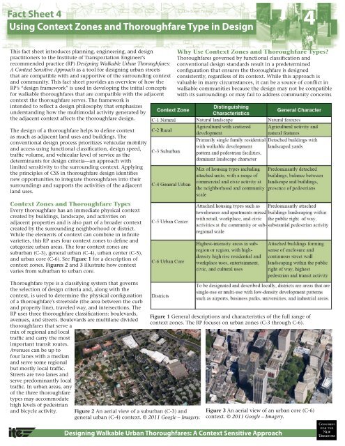
<strong>Context</strong> <strong>Zones</strong> <strong>and</strong> <strong>Thoroughfare</strong> <strong>Type</strong>s<br />
Every thoroughfare has an immediate physical context<br />
created by build<strong>in</strong>gs, l<strong>and</strong>scape, <strong>and</strong> activities on<br />
adjacent properties <strong>and</strong> is also part of a broader context<br />
created by the surround<strong>in</strong>g neighborhood or district.<br />
While the elements of context can comb<strong>in</strong>e <strong>in</strong> <strong>in</strong>f<strong>in</strong>ite<br />
varieties, this RP uses four context zones to def<strong>in</strong>e <strong>and</strong><br />
categorize urban areas. The four context zones are<br />
suburban (C-3), general urban (C-4), urban center (C-5),<br />
<strong>and</strong> urban core (C-6). See Figure 1 for a description of<br />
context zones. Figures 2 <strong>and</strong> 3 illustrate how context<br />
varies from suburban to urban core.<br />
<strong>Thoroughfare</strong> type is a classify<strong>in</strong>g system that governs<br />
the selection of design criteria <strong>and</strong>, along with the<br />
context, is used to determ<strong>in</strong>e the physical configuration<br />
of a thoroughfare’s streetside (the area between the curb<br />
<strong>and</strong> property l<strong>in</strong>e), traveled way, <strong>and</strong> <strong>in</strong>tersections. The<br />
RP uses three thoroughfare classifications: boulevards,<br />
avenues, <strong>and</strong> streets. Boulevards are multilane divided<br />
thoroughfares that serve a<br />
mix of regional <strong>and</strong> local<br />
traffic <strong>and</strong> carry the most<br />
important transit routes.<br />
Avenues can be up to<br />
four lanes with a median<br />
<strong>and</strong> serve some regional<br />
but mostly local traffic.<br />
Streets are two lanes <strong>and</strong><br />
serve predom<strong>in</strong>antly local<br />
traffic. In urban areas, any<br />
of the three thoroughfare<br />
types may accommodate<br />
high levels of pedestrian<br />
<strong>and</strong> bicycle activity.<br />
Figure 2 An aerial view of a suburban (C-3) <strong>and</strong><br />
general urban (C-4) context. © 2011 Google – Imagery.<br />
Figure 1 General descriptions <strong>and</strong> characteristics of the full range of<br />
context zones. The RP focuses on urban zones (C-3 through C-6).<br />
Figure 3 An aerial view of an urban core (C-6)<br />
context. © 2011 Google – Imagery.<br />
<strong>Design</strong><strong>in</strong>g Walkable Urban <strong>Thoroughfare</strong>s: A <strong>Context</strong> Sensitive Approach
<strong>and</strong> <strong>in</strong>terests. The concept of context zones <strong>and</strong> thoroughfare<br />
types provides guidance that supplements conventional design<br />
st<strong>and</strong>ards. These concepts <strong>in</strong>form the designer of the needs of a<br />
specific context <strong>and</strong> encourage work<strong>in</strong>g with stakeholders <strong>and</strong><br />
the community to create compatible thoroughfare designs.<br />
Why is the RP Different from Conventional<br />
Practice<br />
Conventional thoroughfare design is driven by traffic dem<strong>and</strong><br />
<strong>and</strong> level of service objectives. The design process usually starts<br />
with functional classification <strong>and</strong> number of lanes. These<br />
fundamental criteria (functional class <strong>and</strong> lanes) are <strong>in</strong>dependent<br />
of the adjacent context except whether the thoroughfare is<br />
located <strong>in</strong> a rural or urban sett<strong>in</strong>g.<br />
A design process <strong>in</strong>tegrat<strong>in</strong>g the pr<strong>in</strong>ciples of CSS<br />
emphasizes that as context changes, thoroughfare design<br />
should also change to support the activity generated by the<br />
context. As the <strong>in</strong>tensity of adjacent l<strong>and</strong> uses <strong>in</strong>crease, the<br />
streetside should also accommodate the result<strong>in</strong>g <strong>in</strong>crease <strong>in</strong><br />
the diversity of functions. Similarly, the traveled way should<br />
emphasize support for context-related activities such as on-street<br />
park<strong>in</strong>g, bike travel, transit stops, l<strong>and</strong> access, <strong>and</strong> pedestrianfriendly<br />
<strong>in</strong>tersections, often requir<strong>in</strong>g the need to balance<br />
automobile capacity <strong>and</strong> other multimodal design elements.<br />
Select<strong>in</strong>g a <strong>Context</strong> Zone<br />
Much like the “rural” <strong>and</strong> “urban” classifications that are used<br />
<strong>in</strong> select<strong>in</strong>g design criteria <strong>in</strong> A Policy on the Geometric <strong>Design</strong><br />
of Streets <strong>and</strong> Highways by the American Association of State<br />
Highway <strong>and</strong> Transportation Officials, context zones are a basic<br />
determ<strong>in</strong>ant of a walkable thoroughfare’s design criteria. The<br />
RP def<strong>in</strong>es <strong>and</strong> describes context zones.<br />
Guidel<strong>in</strong>es for identify<strong>in</strong>g context zones<br />
<strong>in</strong>clude:<br />
• Consider both exist<strong>in</strong>g conditions <strong>and</strong><br />
plans for the future, recogniz<strong>in</strong>g that<br />
thoroughfares often last longer than<br />
adjacent build<strong>in</strong>gs;<br />
• Assess area plans <strong>and</strong> review general,<br />
comprehensive, <strong>and</strong> specific plans, zon<strong>in</strong>g<br />
codes, <strong>and</strong> community goals. These<br />
often provide detailed guidance on the<br />
vision for the area;<br />
• Compare the area’s predom<strong>in</strong>ant l<strong>and</strong> use<br />
patterns, build<strong>in</strong>g types, <strong>and</strong> l<strong>and</strong> uses to<br />
the characteristics presented <strong>in</strong> the RP;<br />
• Consider divid<strong>in</strong>g the area <strong>in</strong>to two or<br />
more context zones if its diverse urban<br />
characteristics span multiple context zones;<br />
• Identify current levels of pedestrian,<br />
bicycle, <strong>and</strong> transit activity <strong>and</strong> estimate future transportation<br />
activity based on the type, mix, <strong>and</strong> proximity of l<strong>and</strong> uses.<br />
Good mobility for all users is a strong <strong>in</strong>dicator of urban<br />
context; <strong>and</strong><br />
• Consider the area’s exist<strong>in</strong>g <strong>and</strong> future characteristics<br />
beyond the thoroughfare design, possibly extend<strong>in</strong>g<br />
consideration to <strong>in</strong>clude entire neighborhoods or districts.<br />
Select<strong>in</strong>g <strong>Thoroughfare</strong> <strong>Type</strong>s<br />
The RP emphasizes thoroughfares <strong>in</strong> areas with traditional<br />
urban qualities—compact, walkable, highly accessible mixeduse<br />
environments—the design of which is governed by both<br />
functional class <strong>and</strong> thoroughfare type. Use functional class to<br />
determ<strong>in</strong>e:<br />
• Cont<strong>in</strong>uity of the thoroughfare <strong>and</strong> the types of places it<br />
connects;<br />
• Purpose <strong>and</strong> length of trips;<br />
• Level of access to adjacent l<strong>and</strong> use <strong>and</strong> level of access<br />
management;<br />
• <strong>Type</strong> of freight service;<br />
• <strong>Design</strong>ation of primary or secondary emergency response<br />
route; <strong>and</strong><br />
• <strong>Type</strong>s of public transit services (for example, bus, bus rapid<br />
transit, fixed guideway, <strong>and</strong> so forth).<br />
Use thoroughfare types (boulevards, multiway boulevards,<br />
avenues, <strong>and</strong> streets) to select design criteria <strong>and</strong>, along with the<br />
surround<strong>in</strong>g context, to determ<strong>in</strong>e the physical configuration of<br />
the thoroughfare <strong>and</strong> its s<strong>in</strong>gle most important design control:<br />
target speed (see “<strong>Fact</strong> <strong>Sheet</strong> 3”).<br />
Once known, the thoroughfare type is used to identify the<br />
components <strong>and</strong> dimensions of the streetside (e.g., sidewalks,<br />
plant<strong>in</strong>g strips, street furniture), the traveled way (e.g., lanes,<br />
medians, on-street park<strong>in</strong>g, bike lanes), <strong>and</strong> <strong>in</strong>tersections.<br />
Other considerations l<strong>in</strong>ked to the thoroughfare type <strong>in</strong>clude<br />
the type of transit technology <strong>and</strong> service, the level of access<br />
management, <strong>and</strong> the type of freight service that can be<br />
accommodated by the thoroughfare’s design. The relationship<br />
between functional classification <strong>and</strong> thoroughfare type is shown<br />
<strong>in</strong> Figure 4.<br />
Figure 4 The relationship between functional classification <strong>and</strong> thoroughfare type.<br />
<strong>Fact</strong> <strong>Sheet</strong> 4 – <strong>Us<strong>in</strong>g</strong> <strong>Context</strong> <strong>Zones</strong> <strong>and</strong> <strong>Thoroughfare</strong> <strong>Type</strong> <strong>in</strong> <strong>Design</strong><br />
Institute of Transportation Eng<strong>in</strong>eers, 1627 Eye Street, NW, Suite 600, Wash<strong>in</strong>gton, DC 20006 USA; Phone: 202-785-0060; www.ite.org.<br />
This project was funded by FHWA’s Office of Plann<strong>in</strong>g, Environment <strong>and</strong> Realty’s Surface<br />
Transportation Environment <strong>and</strong> Plann<strong>in</strong>g Cooperative Research Program <strong>and</strong> the Environmental Protection Agency.<br />
Download the recommended practice <strong>and</strong> additional fact sheets at: www.ite.org/css/ or www.contextsensitivesolutions.org.