Pilotage Manual - Belfast Harbour
Pilotage Manual - Belfast Harbour
Pilotage Manual - Belfast Harbour

You also want an ePaper? Increase the reach of your titles
YUMPU automatically turns print PDFs into web optimized ePapers that Google loves.
Section: Appendix 7 Rev No. 02<br />
Title: Passage Plans Issue No. a<br />
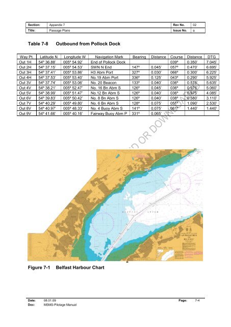
Table 7-8<br />
Outbound from Pollock Dock<br />
Way Pt. Latitude N Longitude W Navigation Mark Bearing Distance Course Distance DTG<br />
Out 1H 54º 36.88’ 005º 54.92’ End of Pollock Dock 039º 0.350’ 7.045’<br />
Out 2H 54º 37.15’ 005º 54.53’ SWN N End 147º 0.045’ 057º 0.470’ 6.695’<br />
Out 3H 54º 37.41’ 005º 53.86’ H3 Abm Port 327º 0.030’ 066º 0.300’ 6.225’<br />
Out 4H 54º 37.53’ 005º 53.40’ No.19 Abm Port 336º 0.125’ 043º 0.290’ 5.925’<br />
Out 3V 54º 37.74’ 005º 53.06’ No. 20 Beacon 133º 0.040’ 036º 0.575’ 5.635’<br />
Out 4V 54º 38.21’ 005º 52.47’ No. 16 Bn Abm S 126º 0.045’ 036º 0.975’ 5.060’<br />
Out 5V 54º 38.99’ 005º 51.47’ No.12 Bn Abm S 126º 0.040’ 036º 0.975’ 4.085’<br />
Out 6V 54º 39.83’ 005º 50.42’ No. 8 Bn Abm S 126º 0.040’ 038º 0.580’ 3.110’<br />
Out 7V 54º 40.29’ 005º 49.80’ No. 6 Bn Abm S 128º 0.075’ 051º 1.090’ 2.530’<br />
Out 8V 54º 40.97’ 005º 48.33’ No. 4 Buoy Abm S 141º 0.075’ 061º 1.440’ 1.440’<br />
Out 9V 54º 41.66’ 005º 40.16’ Fairway Buoy Abm P 331º 0.065’<br />
Figure 7-1<br />
<strong>Belfast</strong> <strong>Harbour</strong> Chart<br />
Date: 08.01.09 Page: 7-4<br />
Doc: MSMS-<strong>Pilotage</strong> <strong>Manual</strong>