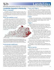
Observed Seismicity - University of Kentucky
Observed Seismicity - University of Kentucky
Observed Seismicity - University of Kentucky

Create successful ePaper yourself
Turn your PDF publications into a flip-book with our unique Google optimized e-Paper software.
2<br />
Introduction<br />
Introduction<br />
The Federal government uses seismic<br />
hazard maps produced by the U.S. Geological<br />
Survey (Frankel and others, 1996) for<br />
seismic safety design. The maps currently<br />
being used show the ground motion with 2<br />
percent probability <strong>of</strong> being exceeded (PE) in<br />
50 years, or once in about 2,500 years. The<br />
maps predict very high ground motion for<br />
western <strong>Kentucky</strong>, the Jackson Purchase<br />
Region in particular. They show peak<br />
ground acceleration (PGA) <strong>of</strong> about 1.0g (or<br />
1 times the acceleration due to gravity) near<br />
Paducah. The maps were used for seismic<br />
design in the 2000 International Building<br />
Code and the 2000 International Residential<br />
Code. IBC-2000 and IRC-2000 use a design<br />
ground acceleration near Paducah <strong>of</strong> about<br />
0.6g. Currently, the highest building design<br />
acceleration used in California is 0.4g. Thus,<br />
the use <strong>of</strong> the USGS hazard maps has resulted<br />
in higher seismic design in the Paducah<br />
area than anywhere in California, even<br />
though it is well documented that California<br />
has higher seismic hazard and risk.<br />
More than 20 years <strong>of</strong> observation and<br />
research at the <strong>University</strong> <strong>of</strong> <strong>Kentucky</strong> have<br />
shown that using the ground motion with 2<br />
percent PE in 50 years results in a seismic<br />
hazard prediction for western <strong>Kentucky</strong>,<br />
especially the Jackson Purchase Region, that<br />
is too high. One <strong>of</strong> the reasons for such high<br />
ground-motion estimates for the Jackson<br />
Purchase Region is the postulated extension<br />
<strong>of</strong> the northern boundary <strong>of</strong> the New<br />
Madrid Seismic Zone. Although it has not<br />
been proven that the active faults <strong>of</strong> the New<br />
Madrid Seismic Zone extend into the Jackson<br />
Purchase Region, such extension was considered<br />
to be the case in many seismic hazard<br />
assessments, including the ones by the U.S.<br />
Geological Survey (Frankel and others, 1996)<br />
and Risk Engineering, Inc. (1999). The postulated<br />
northeast extension <strong>of</strong> the active faults<br />
<strong>of</strong> the New Madrid Seismic Zone also has a<br />
significant impact on siting <strong>of</strong> critical facilities<br />
in the Jackson Purchase Region. For the<br />
central United States, the best information<br />
for determining seismically active zones and<br />
faults is seismicity. Until recently, the lack <strong>of</strong><br />
a dense seismic network in the area has<br />
precluded any definitive determination <strong>of</strong><br />
the northern boundary <strong>of</strong> the New Madrid<br />
Seismic Zone.<br />
With partial support from the <strong>Kentucky</strong><br />
Consortium for Energy and the Environment,<br />
a preliminary seismic hazard assessment<br />
for the Jackson Purchase Region was<br />
conducted between October 1 and December<br />
31, 2002, in order to provide information for<br />
policy- and decision-makers (Wang and<br />
Woolery, 2003; Appendix A). Seven sites in<br />
the Jackson Purchase Region were also<br />
selected for installation <strong>of</strong> new seismic<br />
stations (Wang and Woolery, 2003). These<br />
new seismic stations, combined with previously<br />
installed seismic stations, were designed<br />
to better monitor and locate earthquakes<br />
that occur in the area. These data will<br />
allow researchers to accurately characterize<br />
seismogenic depths and geologic structures.<br />
Furthermore, the results obtained so far<br />
demonstrate why it is vitally important to<br />
install and operate a dense seismic network<br />
covering the northern boundary <strong>of</strong> the New<br />
Madrid Seismic Zone. A dense network has a<br />
number <strong>of</strong> seismometers closely spaced to<br />
collect data from an area <strong>of</strong> special scientific<br />
interest.<br />
The <strong>Kentucky</strong> Geological Survey continues<br />
to fund the maintenance, operation,<br />
monitoring, and dissemination <strong>of</strong> information<br />
from the <strong>Kentucky</strong> Seismic and Strong-<br />
Motion Network. Maintenance and data<br />
archiving at the new stations are performed<br />
monthly. This report summarizes the data<br />
recorded by the new and previously in-