

Prehistoric Avenues and Alignments - English Heritage
Prehistoric Avenues and Alignments - English Heritage
Prehistoric Avenues and Alignments - English Heritage

You also want an ePaper? Increase the reach of your titles
YUMPU automatically turns print PDFs into web optimized ePapers that Google loves.
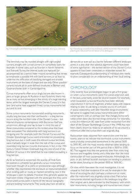
Fig. 3. The plough-levelled Stonehenge Lesser Cursus, Wiltshire, showing as a soil mark.<br />
Fig. 4. Stonehenge, viewed from the north-east, with the final stretch of the Avenue approaching<br />
the monument from the bottom of the photograph.<br />
The terminals may be rounded, straight with right-angled<br />
corners, straight with curved corners, or completely open, for<br />
example. In some cases, such as Scorton in North Yorkshire,<br />
<strong>and</strong> Stanwell, Surrey, the internal banks are replaced (or<br />
accompanied) by a central linear mound, something that serves<br />
to emphasize a possible link with bank barrows, or at least to<br />
underline the difficulties of classifying damaged <strong>and</strong> eroded<br />
monuments on the basis of shape <strong>and</strong> size only. Other possible<br />
variants include pit or post-defined structures at Bainton <strong>and</strong><br />
Godmanchester, both in Cambridgeshire.<br />
Cursus monuments often occur singly, but are also known in<br />
pairs or larger groups. At Rudston in east Yorkshire, there may<br />
be as many as five converging in the vicinity of a large st<strong>and</strong>ing<br />
stone, while the longest example, the Dorset Cursus, is in fact<br />
two (<strong>and</strong> some have suggested three) cursus monuments laid<br />
out end to end.<br />
Some cursus monuments incorporated existing monuments,<br />
usually long barrows, into their earthworks – a long barrow<br />
occurs along the northern side of the Dorset Cursus – but<br />
internal structures contemporary with the cursus itself are<br />
uncommon, although one has to bear in mind the size of<br />
these monuments compared to the limited areas that have<br />
been excavated. The relationship with long barrows is an<br />
intriguing one. For example, both the Dorset Cursus <strong>and</strong> the<br />
Greater Stonehenge Cursus were orientated on pre-existing<br />
long barrows, but in both cases the relevant cursus terminals<br />
were markedly larger in scale than the rest of the cursus, <strong>and</strong><br />
resembled long barrow mounds themselves. In fact, in the 19th<br />
century Canon William Greenwell dug into one of end of the<br />
Rudston ‘A’ cursus in the belief that he was indeed excavating a<br />
long barrow.<br />
As far as function is concerned, the scarcity of finds from<br />
excavations is unhelpful, but generally cursus monuments<br />
have been thought of as paths or processional ways, although<br />
whether they represented the enclosure or monumentalisation<br />
of an existing path or route, or marked something new in the<br />
l<strong>and</strong>scape is open to debate. However, they generally appear to<br />
have been closely integrated with the l<strong>and</strong>scape that they were<br />
constructed across, both in terms of the natural topography<br />
<strong>and</strong> pre-existing monuments. They could, also, have served to<br />
demarcate or even act as a barrier between different l<strong>and</strong>scape<br />
zones. It is also clear that celestial alignments could have been<br />
of some significance – the earliest section of the Dorset Cursus<br />
appears to have been orientated on midwinter sunset, for<br />
example. Consequently, underst<strong>and</strong>ing of individual sites needs<br />
to draw considerably on an underst<strong>and</strong>ing of their local setting.<br />
CHRONOLOGY<br />
Only recently have archaeologists begun to get a firm grasp<br />
on when cursus monuments were first constructed <strong>and</strong> used.<br />
In the past, uncertainty arose for several reasons. For example,<br />
when excavated, cursus earthworks have been relatively<br />
unproductive in terms of diagnostic artefact types, with objects<br />
relating to later re-use being a notable source of confusion.<br />
A spatial relationship with later Neolithic henge monuments<br />
led some to suggest that cursus monuments were either<br />
contemporary with, or perhaps later than, henges. Some early<br />
radiocarbon dates also blurred things somewhat. For example,<br />
a mid-3rd millennium BC date from antler recovered from the<br />
ditch of the Greater Stonehenge Cursus in the 1940s has now<br />
been clearly shown to relate to an episode of re-use around a<br />
millennium after the cursus ditch was originally dug.<br />
Radiocarbon dates obtained from several sites over the last<br />
twenty years or so indicate that earthwork cursus monuments<br />
were probably constructed somewhere in the period 3600<br />
to 3000 BC, with the most recently obtained dates tending to<br />
focus on the earlier part of this period, that is 3600 to 3300<br />
BC. This suggests that they are generally later than many long<br />
barrows <strong>and</strong> megalithic tombs, <strong>and</strong> a little later than the initial<br />
construction of most causewayed enclosures. Interestingly, the<br />
post- or pit- defined Scottish examples are tending to produce<br />
earlier dates, focusing on the period 4000 to 3600 BC.<br />
On sites which have seen the most investigation, it is not<br />
unusual to find clear evidence of re-use, for example in the<br />
form of recutting the ditch perhaps a millennium or more<br />
after the monument was originally constructed. That cursus<br />
monuments retained significance in the l<strong>and</strong>scape long after<br />
their original use is demonstrated by the frequency with which<br />
later monuments, including henges <strong>and</strong> round barrows, cluster<br />
<strong>English</strong> <strong>Heritage</strong><br />
Introductions to <strong>Heritage</strong> Assets<br />
<strong>Prehistoric</strong> <strong>Avenues</strong> <strong>and</strong> <strong>Alignments</strong><br />
3


