15 The Cropland Data Layer (CDL)
15 The Cropland Data Layer (CDL)
15 The Cropland Data Layer (CDL)

Create successful ePaper yourself
Turn your PDF publications into a flip-book with our unique Google optimized e-Paper software.
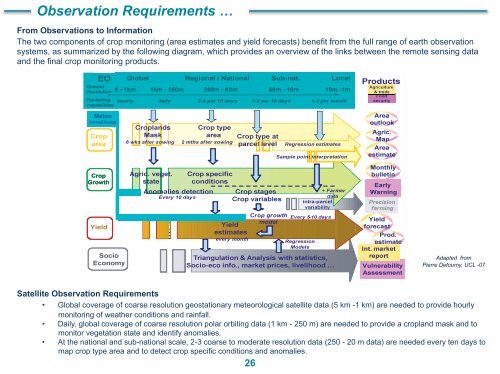
14 <strong>The</strong> Remote Sensing based Agricultural Land Monitoring System of IKI, Russia<br />
<strong>The</strong> Space Research Institute of Russian Academy of Sciences (IKI) has led the project of Russian Ministry of Agriculture in developing the<br />
state agricultural monitoring system based on remote sensing data aimed at monitoring of agricultural lands status, crop acreage estimation at<br />
district level, yield forecasting, and assessment of crop damage due to unfavorable natural conditions.<br />
Objectives: In-season, multiple assessment of crops at federal, regional (oblast), district levels and<br />
production forecasting.<br />
Procedures: <strong>The</strong> monitoring system is based on the use of multi-source data, such as regional<br />
agricultural committees, satellite remote sensing data (mainly MODIS) and ground agro-meteorological<br />
observations.<br />
A special software chain has been developed for raw MODIS data pre-processing. Crop and arable lands<br />
acreage assessment is performed on the basis of NDVI and PVI time-profile analysis.<br />
MODIS derived vegetation indices and weather data are used for crop yield prediction, based on regression<br />
model and similarity analysis (identification of analogue years).<br />
Results: Yearly assessment of acreage of arable lands, winter, summer crops and fallow lands at country<br />
and province (oblast) level. Yield prediction for main crops at province (oblast) level, starting from the<br />
beginning of growing season up to the end of the season with weekly prediction updating.<br />
Ad-hoc analysis of impact of drought and spring frosts.<br />
Impact assessment of 2009 drought<br />
in Southern Russia<br />
Partners:<br />
• Main Computation Centre of the Ministry of Agriculture of Russia<br />
• Province’s Remote Sensing Centers (St. Petersburg, Obninsk)<br />
• State Universities (Moscow, Krasnoyarsk, Samara)<br />
To know more ?<br />
Result from crop recognition based on MODIS<br />
(different colors indicate different crops)<br />
24<br />
• Visit: http://www.agrocosmos.gvc.ru/<br />
• Contact: Eugeny LOUPIAN, evgeny@d902.iki.rssi.ru