Operational Range Assessment Program (ORAP) Phase II ... - E2S2
Operational Range Assessment Program (ORAP) Phase II ... - E2S2
Operational Range Assessment Program (ORAP) Phase II ... - E2S2

Create successful ePaper yourself
Turn your PDF publications into a flip-book with our unique Google optimized e-Paper software.
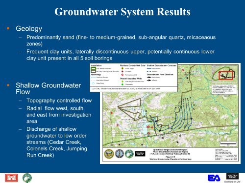
• Geology<br />
Groundwater System Results<br />
– Predominantly sand (fine- to medium-grained, sub-angular quartz, micaceaous<br />
zones)<br />
– Frequent clay units, laterally discontinuous upper, potentially continuous lower<br />
clay unit present in all 5 soil borings<br />
• Shallow Groundwater<br />
Flow<br />
– Topography controlled flow<br />
– Radial flow west, south,<br />
and east from investigation<br />
area<br />
– Discharge of shallow<br />
groundwater to low order<br />
streams (Cedar Creek,<br />
Colonels Creek, Jumping<br />
Run Creek)