

Download Guidebook as .pdf (29.1 Mb) - Carolina Geological Society
Download Guidebook as .pdf (29.1 Mb) - Carolina Geological Society
Download Guidebook as .pdf (29.1 Mb) - Carolina Geological Society

Create successful ePaper yourself
Turn your PDF publications into a flip-book with our unique Google optimized e-Paper software.
GEOLOGY OF THE WESTERN PART OF THE CAROLINA TERRANE IN NORTHWESTERN SOUTH CAROLINA<br />
skarn consisted primarily of actinolite, diopside, and scapolite<br />
with minor amounts of talc, phlogopite, and other minerals.<br />
Two of Don Secor’s and Bob Hatcher’s students worked<br />
on the Inner Piedmont-<strong>Carolina</strong> Terrane Boundary in the<br />
vicinity of the marble locations. John Horkowitz (1984)<br />
worked in the Philson Crossroad Quadrangle and John Willis<br />
(1984) in the Cross Anchor Quadrangle to the north. The<br />
Gregory Kiln and Quarry location lies along the boundary<br />
between these two quadrangles. Both workers <strong>as</strong>sign the<br />
dolomitic marbles to the Inner Piedmont.<br />
Clark Niewendorp (1993) visited Raysor’s, M<strong>as</strong>ters’,<br />
and Mahaffey’s Kilns and the kiln on Walnut Creek referenced<br />
by Ruffin (1843) and Tuomey (1848). This latter kiln<br />
Niewendorp named Martin’s Kiln b<strong>as</strong>ed on the proximity of<br />
a nearby road of the same name and references to the ownership<br />
of the land by an L. Martin found in Kyzer and Hellam<br />
(1883) and a J. Martin found in Sloan (1908). Exact locations<br />
to these kilns can be found in Niewendorp (1993).<br />
The present owner of the M<strong>as</strong>ters’ Kiln site is Mr. Larry<br />
McKellar of Greenwood, South <strong>Carolina</strong>. Mr. McKeller is<br />
very interested in the history of the quarry and in preserving<br />
what remains of the kiln and building. He h<strong>as</strong> graciously<br />
granted permission for our visit to the site.<br />
DESCRIPTIONS OF THE LAURENS COUNTY<br />
KILNS<br />
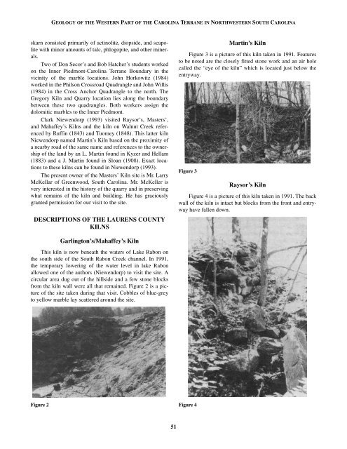
Martin’s Kiln<br />
Figure 3 is a picture of this kiln taken in 1991. Features<br />
to be noted are the closely fitted stone work and an air hole<br />
called the “eye of the kiln” which is located just below the<br />
entryway.<br />
Figure 3<br />
Raysor’s Kiln<br />
Figure 4 is a picture of this kiln taken in 1991. The back<br />
wall of the kiln is intact but blocks from the front and entryway<br />
have fallen down.<br />
Garlington’s/Mahaffey’s Kiln<br />
This kiln is now beneath the waters of Lake Rabon on<br />
the south side of the South Rabon Creek channel. In 1991,<br />
the temporary lowering of the water level in lake Rabon<br />
allowed one of the authors (Niewendorp) to visit the site. A<br />
circular area dug out of the hillside and a few stone blocks<br />
from the kiln wall were all that remained. Figure 2 is a picture<br />
of the site taken during that visit. Cobbles of blue-grey<br />
to yellow marble lay scattered around the site.<br />
Figure 2<br />
Figure 4<br />
51


