JOURNEYS ON AN ANCIENT ROAD El Camino Real de Tierra ...
JOURNEYS ON AN ANCIENT ROAD El Camino Real de Tierra ...
JOURNEYS ON AN ANCIENT ROAD El Camino Real de Tierra ...

Create successful ePaper yourself
Turn your PDF publications into a flip-book with our unique Google optimized e-Paper software.
<strong>JOURNEYS</strong> <strong>ON</strong> <strong>AN</strong> <strong>AN</strong>CIENT <strong>ROAD</strong><br />
<strong>El</strong> <strong>Camino</strong> <strong>Real</strong> <strong>de</strong> <strong>Tierra</strong> A<strong>de</strong>ntro Auto Tour<br />
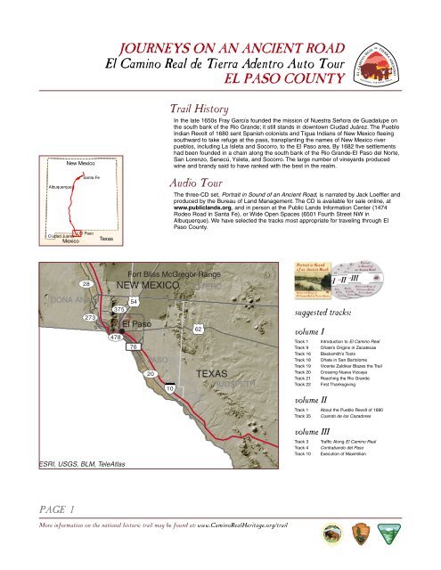
EL PASO COUNTY<br />
New Mexico<br />
Santa Fe<br />
Albuquerque<br />
<strong>El</strong> Paso<br />
Cíudad Juarez<br />
Mexico<br />
Texas<br />
Trail History<br />
In the late 1650s Fray García foun<strong>de</strong>d the mission of Nuestra Señora <strong>de</strong> Guadalupe on<br />
the south bank of the Rio Gran<strong>de</strong>; it still stands in downtown Ciudad Juárez. The Pueblo<br />
Indian Revolt of 1680 sent Spanish colonists and Tigua Indians of New Mexico fleeing<br />
southward to take refuge at the pass, transplanting the names of New Mexico river<br />
pueblos, including La Isleta and Socorro, to the <strong>El</strong> Paso area. By 1682 five settlements<br />
had been foun<strong>de</strong>d in a chain along the south bank of the Rio Gran<strong>de</strong>-<strong>El</strong> Paso <strong>de</strong>l Norte,<br />
San Lorenzo, Senecú, Ysleta, and Socorro. The large number of vineyards produced<br />
wine and brandy said to have ranked with the best in the realm.<br />
Audio Tour<br />
The three-CD set, Portrait in Sound of an Ancient Road, is narrated by Jack Loeffler and<br />
produced by the Bureau of Land Management. The CD is available for sale online, at<br />
www.publiclands.org, and in person at the Public Lands Information Center (1474<br />
Ro<strong>de</strong>o Road in Santa Fe), or Wi<strong>de</strong> Open Spaces (6501 Fourth Street NW in<br />
Albuquerque). We have selected the tracks most appropriate for traveling through <strong>El</strong><br />
Paso County.<br />
28<br />
D<strong>ON</strong>A <strong>AN</strong>A<br />
273<br />
NEW MEXICO<br />
54<br />
375<br />
<strong>El</strong> Paso<br />
478<br />
76<br />
Fort Bliss McGregor Range<br />
EL PASO<br />
20<br />
10<br />
OTERO<br />
62<br />
TEXAS<br />
HUDSPETH<br />
suggested tracks:<br />
volume I<br />
Track 1<br />
Track 9<br />
Track 16<br />
Track 18<br />
Track 19<br />
Track 20<br />
Track 21<br />
Track 22<br />
volume II<br />
Introduction to <strong>El</strong> <strong>Camino</strong> <strong>Real</strong><br />
Oñate’s Origins in Zacatecas<br />
Blacksmith’s Tools<br />
Oñate in San Bartolome<br />
Vicente Zaldivar Blazes the Trail<br />
Crossing Nueva Vizcaya<br />
Reaching the Rio Gran<strong>de</strong><br />
First Thanksgiving<br />
Track 1 About the Pueblo Revolt of 1680<br />
Track 35 Cuando <strong>de</strong> los Cazadores<br />
ESRI, USGS, BLM, TeleAtlas<br />
volume III<br />
Track 3 Traffic Along <strong>El</strong> <strong>Camino</strong> <strong>Real</strong><br />
Track 4 Contrabando <strong>de</strong>l Paso<br />
Track 10 Execution of Maximilian<br />
PAGE 1<br />
More information on the national historic trail may be found at: www.<strong>Camino</strong><strong>Real</strong>Heritage.org/trail
<strong>JOURNEYS</strong> <strong>ON</strong> <strong>AN</strong> <strong>AN</strong>CIENT <strong>ROAD</strong><br />
<strong>El</strong> <strong>Camino</strong> <strong>Real</strong> <strong>de</strong> <strong>Tierra</strong> A<strong>de</strong>ntro Auto Tour<br />
EL PASO COUNTY<br />
Franklin<br />
Mountains<br />
Texas<br />
20<br />
Fort Bliss<br />
Military Reservation<br />
New Mexico<br />
Keystone Park<br />
Boundary Marker #1<br />
Oñate<br />
Crossing<br />
Mexico<br />
85<br />
<strong>El</strong> Paso<br />
357<br />
Mission Trail/Ysleta Pueblo<br />
Cíudad<br />
Juarez<br />
Mission Trail/<br />
Socorro<br />
258<br />
Mission Trail/<br />
San <strong>El</strong>izario<br />
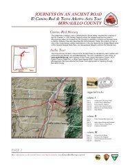
Gui<strong>de</strong> to Auto Tour Route<br />
(North to South)<br />
> Take New Mexico Highway 478 south<br />
> NM 478 becomes Texas Highway 20 at the state line<br />
> Follow the road south to Texas Highway 375<br />
> Go south on 375<br />
> Turn south onto Texas Highway 20<br />
25<br />
85<br />
478<br />
357<br />
U.S. Interstate<br />
U.S. Route<br />
State Highway<br />
County Road<br />
Historic Site/Point of Interest<br />
Auto Tour Route<br />
<strong>Camino</strong> <strong>Real</strong> <strong>de</strong> <strong>Tierra</strong> A<strong>de</strong>ntro<br />
National Historic Trail<br />
PAGE 2<br />
0 5 10 miles<br />
More information on the national historic trail may be found at: www.<strong>Camino</strong><strong>Real</strong>Heritage.org/trail
<strong>JOURNEYS</strong> <strong>ON</strong> <strong>AN</strong> <strong>AN</strong>CIENT <strong>ROAD</strong><br />
<strong>El</strong> <strong>Camino</strong> <strong>Real</strong> <strong>de</strong> <strong>Tierra</strong> A<strong>de</strong>ntro Auto Tour<br />
EL PASO COUNTY<br />
Dolor sit abetsen fome ab. Dolor sit<br />
abetsen fome ab.<br />
Dolor sit abetsen fome ab. Dolor sit<br />
abetsen fome ab.<br />
Historic and Cultural Attractions<br />
©<br />
Oñate’s Crossing<br />
A small plaque commemorates Oñate's crossing of the Rio Gran<strong>de</strong> on the southern portion of<br />
the trail behind what is now La Hacienda Restaurant on Paisano Drive.<br />
arz<br />
Keystone Park<br />
This park is <strong>de</strong>signated to preserve and protect the Keystone Wetlands and Archaeological<br />
site through the study of the archaeological site and the restoration and enhancement of the<br />
wetlands; to foster an appreciation for the beauty of Chihuahuan Desert through the Desert<br />
Botanical gar<strong>de</strong>ns; to provi<strong>de</strong> for the education of adults and children of the region, the nation<br />
and the world about the plants and wildlife of the Northern Chihuahuan Desert and the<br />
Archaic Period civilization.<br />
©<br />
Boundary Marker #1<br />
In 1891, a boundary commission was appointed by the U.S. and Mexican governments to<br />
resurvey and mark the bor<strong>de</strong>r from <strong>El</strong> Paso/ Juarez west to the Pacific. 258 six-foot tall, iron<br />
and concrete columns were fabricated in <strong>El</strong> Paso, and placed along the international<br />
boundary, bearing plaques that read “Boundary of the United States [or Mexico], treaty of<br />
1853, reestablished by the treaties of 1882–1889” in English and Spanish. Because the<br />
survey began in Texas, the markers were renumbered, with the first on the Rio Gran<strong>de</strong>, near<br />
Oñate’s first crossing.<br />
F<br />
Ysleta <strong>de</strong>l Sur Mission<br />
On October 12, 1680, midway between the Spanish settlement of Santísimo Sacramento and<br />
the Indian settlement of San Antonio, the first Mass in Texas was celebrated at a site near<br />
that of present Ysleta, which was placed on what is now the Texas si<strong>de</strong> by the shifting river in<br />
1829; Ysleta thus has a claim to being the ol<strong>de</strong>st town in Texas.<br />
Mission Ysleta, in <strong>El</strong> Paso, Texas, was first erected in 1692. Through a series of floods and<br />
fires, the mission has been rebuilt three times. Named for the patron saint of the Tiguas, the<br />
mission was first known as San Antonio <strong>de</strong> la Ysleta. The beautiful silver bell tower was ad<strong>de</strong>d<br />
in the 1880s. The missions of <strong>El</strong> Paso have a tremendous history spanning three centuries.<br />
They are consi<strong>de</strong>red the longest, continuously occupied religious structures within the United<br />
States and as far as we know, the churches have never missed one day of services.<br />
F<br />
Socorro Mission<br />
Built of adobe in 1692, Mission Socorro, in <strong>El</strong> Paso, Texas, also experienced natural disasters<br />
through her history lending her to be rebuilt several times. The famous Statue of Saint Michael<br />
was brought to the mission from Mexico by oxcart in the early 1800s. One will also find an<br />
excellent example of Indian and Spanish architecture including carved ceiling beams called<br />
“vigas” and bell tower.<br />
PAGE 3<br />
More information on the national historic trail may be found at: www.<strong>Camino</strong><strong>Real</strong>Heritage.org/trail
<strong>JOURNEYS</strong> <strong>ON</strong> <strong>AN</strong> <strong>AN</strong>CIENT <strong>ROAD</strong><br />
<strong>El</strong> <strong>Camino</strong> <strong>Real</strong> <strong>de</strong> <strong>Tierra</strong> A<strong>de</strong>ntro Auto Tour<br />
EL PASO COUNTY<br />
Dolor sit abetsen fome ab. Dolor sit<br />
abetsen fome ab.<br />
Crossing the<br />
Bor<strong>de</strong>r<br />
As so many thousands have<br />
done over the centuries, cross<br />
the Rio Gran<strong>de</strong> to discover the<br />
rich history found on the<br />
southern shores. Since <strong>El</strong> Paso<br />
<strong>de</strong>l Norte was divi<strong>de</strong>d in two by<br />
the Treaty of Guadalupe<br />
Hidalgo, the city south of the<br />
Rio Gran<strong>de</strong>, Ciudad Juarez,<br />
has flourished, growing to four<br />
times the size of its American<br />
neighbor. The city features a<br />
fantastic museum, as well as<br />
historic sites such as the<br />
mission of Nuestra Señora <strong>de</strong><br />
Guadalupe, built in 1659, and<br />
the headquarters of Pancho<br />
Villa and Pascual Orozco<br />
during their 1911 occupation of<br />
the city, now the Museo<br />
Historico,<br />
PAGE 4<br />
F<br />
San <strong>El</strong>izario Mission<br />
San <strong>El</strong>izario, in <strong>El</strong> Paso, Texas, was built first as a military presidio to protect the citizens of<br />
the river settlements from Apache attacks in 1789. The structure as it stands today has<br />
interior pillars, <strong>de</strong>tailed in gilt, and an extraordinary painted tin ceiling. Listed on the National<br />
Register. The area around the mission is often enjoyed as a historic walking tour.<br />
z<br />
Magoffin Home State Historic Site<br />
Built in 1875 by Joseph Magoffin, this 19-room adobe home is a prime example of Southwest<br />
territorial style architecture. Three generations of the Magoffin Family lived in the house.<br />
Magoffin was an <strong>El</strong> Paso booster, active in a range of civic and political affairs, and served as<br />
mayor for four terms. His father, James Wiley Magoffin, was a tra<strong>de</strong>r on the Santa Fe and<br />
Chihuahua trails, and accompanied Stephen Watts Kearny from Missouri to Santa Fe in 1846.<br />
Visitors to the home enjoy docent-led tours; several annual events are held as well.<br />
F<br />
Chamizal National Memorial<br />
The Chamizal Treaty was a milestone in diplomatic relations between Mexico and the United<br />
States in 1963. Chamizal National Memorial was established to commemorate this peaceful<br />
settlement which was an end to a century-long boundary dispute between the neighboring<br />
countries. Far more than mere acreage, Chamizal is an i<strong>de</strong>a, a dynamic process, <strong>de</strong>dicated to<br />
furthering the spirit of un<strong>de</strong>rstanding and goodwill between two nations that share one bor<strong>de</strong>r.<br />
Utilizing the visual, literary and performing arts as a medium of interchange, Chamizal serves<br />
as an open door to help people better un<strong>de</strong>rstand not only other cultures, but their own<br />
cultural roots as well.<br />
This 55-acre urban park features spectacular views of the Franklin Mountains, a nature trail,<br />
and a picnic area. Cultural events are staged here throughout the year.<br />
Natural Attractions<br />
!rIp<br />
Franklin Mountains State Park<br />
Overlooking the Rio Gran<strong>de</strong>, the Franklin Mountains are the northern ramparts of the Paso<br />
<strong>de</strong>l Norte (Pass of the North), leading from Mexico into what is now the United States.<br />
For hundreds of years, native Americans, soldiers, priests, tra<strong>de</strong>rs, adventurers, gold-seekers,<br />
entrepreneurs, and colonists have passed through the gap in both directions in an endless<br />
procession of expansion, settlement, raiding, and conquest.<br />
Today, the Franklin Mountains are surroun<strong>de</strong>d by urban <strong>El</strong> Paso, and are managed by Texas<br />
Parks and Wildlife Department.<br />
Contacts<br />
Franklin Mountains State Park 915-566-6441<br />
Magoffin Home State Historic Site 915-533-5147<br />
Keystone Park 915-584-0563<br />
Chamizal National Memorial 915-532-7273<br />
<strong>El</strong> Paso Convention and Visitor’s Bureau 915-534-0601<br />
Ciudad Juarez Oficina <strong>de</strong> Convenciones y Visitantes 888-654-0394<br />
Museo Historico <strong>de</strong> Cd. Juarez 612-4707 or 612-2969<br />
More information on the national historic trail may be found at: www.<strong>Camino</strong><strong>Real</strong>Heritage.org/trail