Port Authority Brochure PDF - City of Wabasha
Port Authority Brochure PDF - City of Wabasha
Port Authority Brochure PDF - City of Wabasha

You also want an ePaper? Increase the reach of your titles
YUMPU automatically turns print PDFs into web optimized ePapers that Google loves.
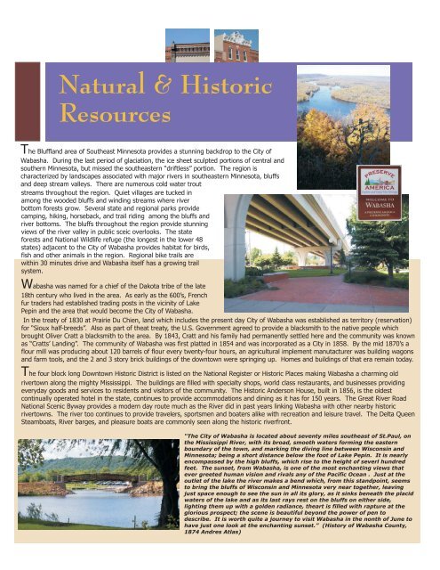
Natural & Historic<br />
Resources<br />
The Bluffland area <strong>of</strong> Southeast Minnesota provides a stunning backdrop to the <strong>City</strong> <strong>of</strong><br />
<strong>Wabasha</strong>. During the last period <strong>of</strong> glaciation, the ice sheet sculpted portions <strong>of</strong> central and<br />
southern Minnesota, but missed the southeastern “driftless” portion. The region is<br />
characterized by landscapes associated with major rivers in southeastern Minnesota, bluffs<br />
and deep stream valleys. There are numerous cold water trout<br />
streams throughout the region. Quiet villages are tucked in<br />
among the wooded bluffs and winding streams where river<br />
bottom forests grow. Several state and regional parks provide<br />
camping, hiking, horseback, and trail riding among the bluffs and<br />
river bottoms. The bluffs throughout the region provide stunning<br />
views <strong>of</strong> the river valley in public sceic overlooks. The state<br />
forests and National Wildlife refuge (the longest in the lower 48<br />
states) adjacent to the <strong>City</strong> <strong>of</strong> <strong>Wabasha</strong> provides habitat for birds,<br />
fish and other animals in the region. Regional bike trails are<br />
within 30 minutes drive and <strong>Wabasha</strong> itself has a growing trail<br />
system.<br />
<strong>Wabasha</strong> was named for a chief <strong>of</strong> the Dakota tribe <strong>of</strong> the late<br />
18th century who lived in the area. As early as the 600’s, French<br />
fur traders had established trading posts in the vicinity <strong>of</strong> Lake<br />
Pepin and the area that would become the <strong>City</strong> <strong>of</strong> <strong>Wabasha</strong>.<br />
In the treaty <strong>of</strong> 1830 at Prairie Du Chien, land which includes the present day <strong>City</strong> <strong>of</strong> <strong>Wabasha</strong> was established as territory (reservation)<br />
for “Sioux half-breeds”. Also as part <strong>of</strong> theat treaty, the U.S. Government agreed to provide a blacksmith to the native people which<br />
brought Oliver Cratt a blacksmith to the area. By 1843, Cratt and his family had permanently settled here and the community was known<br />
as “Cratts’ Landing”. The community <strong>of</strong> <strong>Wabasha</strong> was first platted in 1854 and was incorporated as a <strong>City</strong> in 1858. By the mid 1870’s a<br />
flour mill was producing about 120 barrels <strong>of</strong> flour every twenty-four hours, an agricultural implement manutacturer was building wagons<br />
and farm tools, and the 2 and 3 story brick buildings <strong>of</strong> the downtown were springing up. Homes and buildings <strong>of</strong> that era remain today.<br />
T<br />
he four block long Downtown Historic District is listed on the National Register or Historic Places making <strong>Wabasha</strong> a charming old<br />
rivertown along the mighty Mississippi. The buildings are filled with specialty shops, world class restaurants, and businesses providing<br />
everyday goods and services to residents and visitors <strong>of</strong> the community. The Historic Anderson House, built in 1856, is the oldest<br />
continually operated hotel in the state, continues to provide accommodations and dining as it has for 150 years. The Great River Road<br />
National Scenic Byway provides a modern day route much as the River did in past years linking <strong>Wabasha</strong> with other nearby historic<br />
rivertowns. The river too continues to provide travelers, sportsmen and boaters alike with recreation and leisure travel. The Delta Queen<br />
Steamboats, River barges, and pleasure boats are commonly seen along the historic riverfront.<br />
“The <strong>City</strong> <strong>of</strong> <strong>Wabasha</strong> is located about seventy miles southeast <strong>of</strong> St.Paul, on<br />
the Mississippi River, with its broad, smooth waters forming the eastern<br />
boundary <strong>of</strong> the town, and marking the diving line between Wisconsin and<br />
Minnesota; being a short distance below the foot <strong>of</strong> Lake Pepin. It is nearly<br />
encompassed by the high bluffs, which rise to the height <strong>of</strong> severl hundred<br />
feet. The sunset, from <strong>Wabasha</strong>, is one <strong>of</strong> the most enchanting views that<br />
ever greeted human vision and rivals any <strong>of</strong> the Pacific Ocean . Just at the<br />
outlet <strong>of</strong> the lake the river makes a bend which, from this standpoint, seems<br />
to bring the bluffs <strong>of</strong> Wisconsin and Minnesota very near together, leaving<br />
just space enough to see the sun in all its glory, as it sinks beneath the placid<br />
waters <strong>of</strong> the lake and as its last rays rest on the bluffs on either side,<br />
lighting them up with a golden radiance, theart is filled with rapture at the<br />
glorious prospect; the scene is beautiful beyond the power <strong>of</strong> pen to<br />
describe. It is worth quite a journey to visit <strong>Wabasha</strong> in the nonth <strong>of</strong> June to<br />
have just one look at the enchanting sunset.” (History <strong>of</strong> <strong>Wabasha</strong> County,<br />
1874 Andres Atlas)