English - EMRC
English - EMRC
English - EMRC

You also want an ePaper? Increase the reach of your titles
YUMPU automatically turns print PDFs into web optimized ePapers that Google loves.
Mapping Africa to unlock wealth<br />
Infoterra is a leading provider of geo-information products and services, which have become<br />
vital for managing the world’s environment, development and security. The Infoterra Group has<br />
approximately 300 employees in the UK, France, Germany and Hungary and an extensive network<br />
of partners covering all five continents.<br />
”<br />
What we are looking to achieve<br />
using geospatial mapping, is<br />
to unlock Africa’s wealth”,<br />
says Simon Ashby, Principal<br />
Consultant with Infoterra. He goes on to explain<br />
that security of land ownership is key<br />
to development, while reliable mapping is a<br />
prerequisite to land and property registration<br />
and ownership.<br />
The total landmass of Africa is 30.3 million<br />
square kilometers while, by contrast,<br />
Argentina, India, China, Western Europe<br />
and the USA, together make up 28.8 million<br />
square kilometers. Meanwhile, the<br />
maps of Africa are completely out of<br />
date, going back to Colonial times. For<br />
instance, the massive urbanisation, which<br />
has taken place in recent decades, has remained<br />
essentially unrecorded.<br />
Geospatial mapping, a digital technology,<br />
which provides detailed and reliable spatial<br />
data, is the 21st century’s answer to<br />
those old fashioned, hand drawn maps to<br />
be found in antique shops.<br />
Raw data, such as accurate land statistics and<br />
infrastructure, is transformed into business<br />
information for the benefit of both the public<br />
and private sectors. The examples of areas of<br />
application of this technology are impressive:<br />
improved land, water and forest management,<br />
biodiversity and conservation,<br />
determining crop prospects and desertification<br />
risks, alerts on natural disasters,<br />
communication network planning<br />
(roads, railways, electricity, telecom…),<br />
establishing accurate topology such as<br />
building heights, etc.<br />
The technology of geospatial mapping<br />
is already being considered and implemented<br />
in a number of developing<br />
countries in Eastern Europe, such as Bulgaria,<br />
Romania, the Balkans, Macedonia and Kosovo<br />
– in particular to settle land ownership issues<br />
exacerbated by the fact that many records<br />
of ownership were lost or destroyed during recent<br />
conflicts.<br />
Today national spatial frameworks can be<br />
created and constantly modified to reflect<br />
changed circumstances on the ground, such as<br />
urbanisation. Britain has had a national mapping<br />
agency since 1791 and, following a comprehensive<br />
digitisation programme, resulting<br />
in the release of Ordinance Survey’s MasterMap®<br />
in 2001, now has one of the most<br />
sophisticated national geographic frameworks<br />
in the developed world.<br />
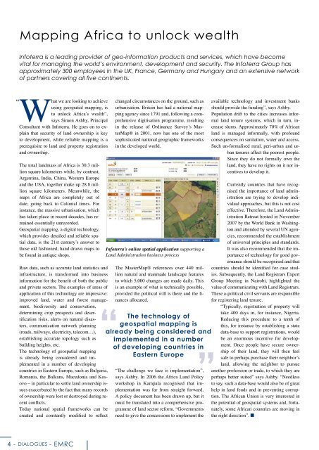
Infoterra’s online spatial application supporting a<br />
Land Administration business process<br />
The MasterMap® references over 440 million<br />
natural and manmade landscape features<br />
to which 5,000 changes are made daily. This<br />
is an example of what is technically possible,<br />
provided the political will is there and the finances<br />
allocated.<br />
The technology of<br />
geospatial mapping is<br />
already being considered and<br />
implemented in a number<br />
of developing countries in<br />
Eastern Europe<br />
“The challenge we face is implementation”,<br />
says Ashby. In 2006 the Africa Land Policy<br />
workshop in Kampala recognised that implementation<br />
was far from straight forward.<br />
A policy document has been drawn up, but it<br />
must be translated into a comprehensive programme<br />
of land sector reform. “Governments<br />
need to give the concessions to implement the<br />
available technology and investment banks<br />
should provide the funding”, says Ashby.<br />
Population drift to the cities increases informal<br />
land tenure systems, which in turn, increase<br />
slums. Approximately 70% of African<br />
land is managed informally, with profound<br />
consequences on sanitation, water and access.<br />
Such un-formalised rural, peri-urban and urban<br />
tenures affect the poorest people.<br />
Since they do not formally own the<br />
land, they have no rights on it nor incentives<br />
to develop it.<br />
Currently countries that have recognised<br />
the importance of land administration<br />
are trying to develop individual<br />
approaches, but this is not cost<br />
effective. Therefore, the Land Administration<br />
Retreat hosted in November<br />
2007 by the World Bank in Washington<br />
and attended by several UN agencies,<br />
recommended the establishment<br />
of universal principles and standards.<br />
It was also recommended that the importance<br />
of technology for good governance<br />
should be recognised and that<br />
countries should be identified for case studies.<br />
Subsequently, the Land Registrars Expert<br />
Group Meeting in Nairobi, highlighted the<br />
value of communicating with Land Registrars.<br />
These a-political civil servants are responsible<br />
for registering land tenure.<br />
“Typically, registration of property will<br />
take 400 days in, for instance, Nigeria.<br />
Reducing this procedure to a tenth of<br />
this, for instance by establishing a state<br />
data-base to support registrations, would<br />
be an enormous incentive for development.<br />
Once people have secure ownership<br />
of their land, they will then feel<br />
safe to perhaps purchase their neighbor’s<br />
land, allowing the neighbor to pursue<br />
another profession or trade, to which they are<br />
perhaps better suited” says Ashby. “Needless<br />
to say, such a data-base would also be of great<br />
help in land feuds and in preventing corruption.<br />
The African Union is very interested in<br />
the potential of geospatial systems and, fortunately,<br />
some African countries are moving in<br />
the right direction”. ■<br />
- DIALOGUES - <strong>EMRC</strong>