OGC - (SIG) 3D
OGC - (SIG) 3D
OGC - (SIG) 3D
Create successful ePaper yourself
Turn your PDF publications into a flip-book with our unique Google optimized e-Paper software.
FOR IMMEDIATE RELEASE<br />
Contact:<br />
Steven Ramage<br />
Executive Director, Marketing and Communications<br />
Open Geospatial Consortium (<strong>OGC</strong>)<br />
Bergen, Norway<br />
sramage@opengeospatial.org<br />
Phone: +47 9862 6865<br />
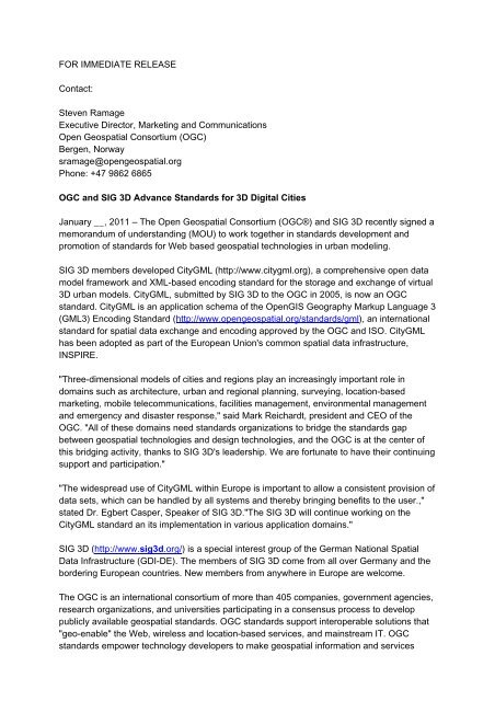
<strong>OGC</strong> and <strong>SIG</strong> <strong>3D</strong> Advance Standards for <strong>3D</strong> Digital Cities<br />
January __, 2011 – The Open Geospatial Consortium (<strong>OGC</strong>®) and <strong>SIG</strong> <strong>3D</strong> recently signed a<br />
memorandum of understanding (MOU) to work together in standards development and<br />
promotion of standards for Web based geospatial technologies in urban modeling.<br />
<strong>SIG</strong> <strong>3D</strong> members developed CityGML (http://www.citygml.org), a comprehensive open data<br />
model framework and XML-based encoding standard for the storage and exchange of virtual<br />
<strong>3D</strong> urban models. CityGML, submitted by <strong>SIG</strong> <strong>3D</strong> to the <strong>OGC</strong> in 2005, is now an <strong>OGC</strong><br />
standard. CityGML is an application schema of the OpenGIS Geography Markup Language 3<br />
(GML3) Encoding Standard (http://www.opengeospatial.org/standards/gml), an international<br />
standard for spatial data exchange and encoding approved by the <strong>OGC</strong> and ISO. CityGML<br />
has been adopted as part of the European Union's common spatial data infrastructure,<br />
INSPIRE.<br />
"Three-dimensional models of cities and regions play an increasingly important role in<br />
domains such as architecture, urban and regional planning, surveying, location-based<br />
marketing, mobile telecommunications, facilities management, environmental management<br />
and emergency and disaster response," said Mark Reichardt, president and CEO of the<br />
<strong>OGC</strong>. "All of these domains need standards organizations to bridge the standards gap<br />
between geospatial technologies and design technologies, and the <strong>OGC</strong> is at the center of<br />
this bridging activity, thanks to <strong>SIG</strong> <strong>3D</strong>'s leadership. We are fortunate to have their continuing<br />
support and participation."<br />
"The widespread use of CityGML within Europe is important to allow a consistent provision of<br />
data sets, which can be handled by all systems and thereby bringing benefits to the user.,"<br />
stated Dr. Egbert Casper, Speaker of <strong>SIG</strong> <strong>3D</strong>."The <strong>SIG</strong> <strong>3D</strong> will continue working on the<br />
CityGML standard an its implementation in various application domains."<br />
<strong>SIG</strong> <strong>3D</strong> (http://www.sig3d.org/) is a special interest group of the German National Spatial<br />
Data Infrastructure (GDI-DE). The members of <strong>SIG</strong> <strong>3D</strong> come from all over Germany and the<br />
bordering European countries. New members from anywhere in Europe are welcome.<br />
The <strong>OGC</strong> is an international consortium of more than 405 companies, government agencies,<br />
research organizations, and universities participating in a consensus process to develop<br />
publicly available geospatial standards. <strong>OGC</strong> standards support interoperable solutions that<br />
"geo-enable" the Web, wireless and location-based services, and mainstream IT. <strong>OGC</strong><br />
standards empower technology developers to make geospatial information and services
accessible and useful with any application that needs to be geospatially enabled. Visit the<br />
<strong>OGC</strong> website at http://www.opengeospatial.org/contact.


