
You also want an ePaper? Increase the reach of your titles
YUMPU automatically turns print PDFs into web optimized ePapers that Google loves.
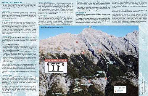
ROUTE DESCRIPTION<br />
This route description begins at the junction of the Mt. <strong>Rundle</strong><br />
Trail and Spray River Trail (see map on other side of this<br />
brochure). The following description is keyed <strong>to</strong> the numbers on<br />
the route pho<strong>to</strong>.<br />
1. Lower Trail<br />
Follow the excellent constructed trail that climbs steadily across<br />
the lower forested slopes of Mt. <strong>Rundle</strong>. As the mountainside<br />
steepens, the trail begins <strong>to</strong> con<strong>to</strong>ur horizontally <strong>to</strong> the right. After<br />
almost an hour of hiking, reach the start of a dozen switchbacks<br />
that lead straight up the slope.<br />
2. First Cliff Bands<br />
On the route pho<strong>to</strong>, notice the series of switchbacks actually leads<br />
up through a band of rocky cliffs that extend across the<br />
mountainside at the same elevation. This obscure cliff band is a<br />
significant hazards associated with the climb. Stay on route!<br />
At the <strong>to</strong>p of the switchbacks, the trail resumes a horizontal<br />
traverse <strong>to</strong> the right and soon heads down across the first of two<br />
large forested ravines. Shortly after the second ravine, the trail<br />
comes <strong>to</strong> an abrupt end at the edge of a large, rocky gully, known<br />
as the Central Gully.<br />
3. Central Gully<br />
The Central Gully marks the end of the hiking trail and the start of<br />
the “scrambling” section of the trip. The route <strong>to</strong> the summit<br />
crosses this gully and ascends <strong>to</strong> the <strong>to</strong>p by way of the forested<br />
ridge beyond.<br />
Two key safety pointers here:<br />
• Do not climb up the Central Gully! Despite appearances, it<br />
is not a safe route <strong>to</strong> the summit. The gully is easy at the start but<br />
gradually steepens, forming dangerously smooth slabs where<br />
several people have been killed!<br />
• On the descent, it is critical <strong>to</strong> return <strong>to</strong> this point and stay on<br />
the hiking trail for the rest of the way down! From across the<br />
gully, the end of the hiking trail is surprisingly difficult <strong>to</strong> see.<br />
Several fatal accidents have occurred when descending climbers<br />
missed the trail and fell while on a shortcut through the first cliff<br />
band that lies 100 m downhill from here. Yellow marker signs<br />
help define the route beyond the gully as a guide back <strong>to</strong> this<br />
crucial route home.<br />
From the end of the hiking trail, descend a few metres and cross<br />
the gully (which may contain some old avalanche snow) <strong>to</strong> the<br />
bot<strong>to</strong>m edge of an open rocky outcrop on the opposite slope.<br />
Scramble around the bot<strong>to</strong>m of the outcrop <strong>to</strong> its right-hand side.<br />
From here, look back and spot the marker at the end of the hiking<br />
trail.<br />
4. Forested Ridge<br />
Scramble up the steep track in the trees just right of the rocky<br />
outcrops. Stick <strong>to</strong> the most obvious path that climbs directly up the<br />
slope. There is no “built” trail—only a few cut trees, and the path is<br />
slippery in places. About 100 m up the slope, the path traverses<br />
horizontally <strong>to</strong> the right and away from the steeper slopes<br />
overlooking the Central Gully.<br />
From here on, the route climbs almost straight up though the<br />
forest. The path is well worn but continuously steep and smooth.<br />
Near treeline the path has eroded badly <strong>to</strong> expose the smooth<br />
bedrock underneath. This entire section can become extremely<br />
slippery when wet.<br />
5. The Dragon’s Back<br />
The slope that the route follows is actually a ridge bounded by the<br />
Central Gully on the left side and another similar large gully on the<br />
right. This ridge leads most of the way <strong>to</strong> the <strong>to</strong>p. Above treeline the<br />
ridge gradually narrows <strong>to</strong> form the “Dragon’s Back”, a sloping<br />
spine of rock between the two gullies. Its surface is the smooth<br />
slope of the limes<strong>to</strong>ne bedrock. For much of the way, it is covered<br />
by loose gravel, and there are steep cliffs on each side. Careful<br />
footing! Look back for landmarks.<br />
6. The Summit<br />
The ascent beyond the Dragon’s Back is a long and straightforward<br />
slog up the loose scree <strong>to</strong> the summit ridge. The ridge crest is a<br />
sharp edge with the vertical east face of Mt. <strong>Rundle</strong> below.<br />
Traverse <strong>to</strong> the right along the ridge for about 100 m (mostly along<br />
the right side of the crest) <strong>to</strong> the summit high point marked by a<br />
cairn. There is a modest flat spot here <strong>to</strong> rest and enjoy the view.<br />
<strong>Mount</strong> <strong>Rundle</strong> viewed from the west<br />
HELICOPTER RESCUE<br />
1 Lower Trail<br />
• Cornices – Stay well back from the edge if there is any snow<br />
along the ridgeline. “Cornice” snow usually hangs out over the<br />
edge of the mountain and forms a deathtrap for the unwary!<br />
• Traversing <strong>to</strong> any other peaks along the ridge is not<br />
recommended. Peaks are farther away than may appear and<br />
require technical climbing skills and equipment.<br />
THE DESCENT<br />
Descend by the same route you climbed. Retrace your<br />
steps. No shortcuts!<br />
Do not attempt an alternate descent down either of the<br />
gullies below. These may appear feasible options when viewed<br />
from the <strong>to</strong>p, but dangerous terrain lies out of sight downhill.<br />
People have been trapped or killed in both gullies.<br />
2<br />
6 Summit<br />
5<br />
First Cliff Bands<br />
Dragon's<br />
Back<br />
Central<br />
Gully<br />
3<br />
4<br />
The Dragon's Back ridge leads down <strong>to</strong> the trees. The yellow<br />
markers guide the way back <strong>to</strong> the Central Gully. If the trail has<br />
been missed and party members have descended <strong>to</strong>o far, the only<br />
choice is <strong>to</strong> climb back up <strong>to</strong> the trail. Do not attempt <strong>to</strong> descend<br />
any cliffs!<br />
Note: Damage <strong>to</strong> the switchback area is caused by people taking<br />
shortcuts on the way down. Please, stay on the path.<br />
You’ve climbed Mt. <strong>Rundle</strong>! If you are interested in more<br />
scrambling at this level, see similar brochures by Parks Canada for<br />
Cascade <strong>Mount</strong>ain near Banff and <strong>Mount</strong> Temple in Lake Louise.<br />
If you have climbed these and want more, then it’s time <strong>to</strong> select a<br />
route from the guidebook Scrambles in the Canadian Rockies, join<br />
the Alpine Club of Canada, hire a certified mountain guide, or take<br />
a rock climbing or mountaineering course. Good luck!<br />
Forested<br />
Ridge<br />
Route/scramble<br />
Hiking trail<br />
Sites of serious<br />
accidents<br />
Pho<strong>to</strong>s: Brad White/Parks Canada<br />
Également offert en français.<br />
C Her Majesty the Queen in Right of Canada<br />
Catalogue No: R64-391/2012E<br />
ISBN: 978-1-100-20161-0