Summary of Pattern Comparison and Concluding Remarks
Summary of Pattern Comparison and Concluding Remarks
Summary of Pattern Comparison and Concluding Remarks

Create successful ePaper yourself
Turn your PDF publications into a flip-book with our unique Google optimized e-Paper software.
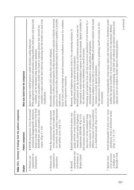
Table 14.1. <strong>Summary</strong> <strong>of</strong> findings from the patterns comparisons<br />
Chapter <strong>Pattern</strong> comparison What was learnt from the comparison<br />
4. <strong>Pattern</strong>s <strong>and</strong> RADAR precipitation versus downscaled Spatio-temporal rainfall patterns exhibit dynamic scaling behaviour.<br />
organisation in precipitation (statistically disaggregated) simulations based on large scale patterns from both With appropriate normalisation <strong>and</strong> dynamic scaling methods, both space <strong>and</strong> space-time<br />
variability can be simulated using stochastic simulation.<br />
RADAR data <strong>and</strong> atmospheric model output. (Figs 4.7, 4.9)<br />
Storm scale atmospheric models were found to simulate patterns that showed less<br />
variability in space <strong>and</strong> time than observed, indicating that the models may need some<br />
modification.<br />
5. <strong>Pattern</strong>s <strong>and</strong><br />
organisation in<br />
evaporation<br />
Point flux measurements <strong>of</strong> evaporation<br />
versus simulations from models based<br />
on remotely sensed surface temperature<br />
<strong>and</strong> surface cover. (Fig. 5.2)<br />
Reasonable agreement with surface flux stations obtained.<br />
Uncertainty in effect <strong>of</strong> heterogeneity on flux measurements <strong>and</strong> lack <strong>of</strong> directly measured<br />
patterns <strong>of</strong> evaporative flux prevented detailed analysis <strong>of</strong> predictive capability or possible<br />
model errors.<br />
State <strong>of</strong> data <strong>and</strong> knowledge <strong>of</strong> spatial interactions insufficient at present for confident<br />
spatial evaporation estimation.<br />
6. Run<strong>of</strong>f,<br />
precipitation <strong>and</strong><br />
soil moisture at<br />
Walnut Gulch<br />
Rainfall interpolated from dense raingauge<br />
network versus estimated from<br />
remotely sensed surface brightness<br />
temperature (ESTAR). (Fig. 6.12)<br />
Soil moisture measured by passive<br />
microwave versus simulated using<br />
various sources <strong>of</strong> variability <strong>and</strong><br />
different amounts <strong>of</strong> data assimilation<br />
in a distributed model. (Figs 6.13, 6.15)<br />
Remotely sensed brightness temperature looks to be a promising estimator <strong>of</strong><br />
precipitation patterns in semi-arid environments.<br />
Rainfall patterns are the dominant control on soil moisture patterns <strong>and</strong> must be<br />
represented to model hydrological response in this environment. Spatial variability at<br />
the sub-hectare scale was influential on run<strong>of</strong>f processes.<br />
Estimating soil properties from soil type deteriorated simulations <strong>of</strong> soil moisture by a<br />
distributed model as compared to using uniform soil properties.<br />
Newtonian nudging was best able to assimilate PBMR soil moisture estimates with model<br />
estimates to correct spatial simulations.<br />
The representation <strong>of</strong> channel losses is critical to predicting run<strong>of</strong>f accurately in this<br />
environment.<br />
7. Spatial snow<br />
cover processes<br />
at Ku¨ htai <strong>and</strong><br />
Reynolds Creek<br />
Aerial photographs <strong>of</strong> snow cover versus<br />
simulations from a distributed model.<br />
(Figs 7.3, 7.4, 7.5)<br />
Inclusion <strong>of</strong> topographically varied energy inputs <strong>and</strong> wind drift in a distributed model<br />
enabled the spatial variability <strong>of</strong> basic cover patterns to be reproduced. Refined<br />
representations <strong>of</strong> avalanching, wind drift <strong>and</strong> reflected <strong>and</strong> emitted radiation from<br />
adjacent areas are needed to further improve simulated patterns.<br />
(continued)<br />
357