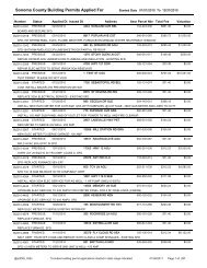
GRD-002: Grading Permit Questionnaire Form - Sonoma County
GRD-002: Grading Permit Questionnaire Form - Sonoma County
GRD-002: Grading Permit Questionnaire Form - Sonoma County

You also want an ePaper? Increase the reach of your titles
YUMPU automatically turns print PDFs into web optimized ePapers that Google loves.
<strong>Grading</strong> <strong>Permit</strong> <strong>Questionnaire</strong><br />
<strong>GRD</strong> - <strong>002</strong><br />
Purpose: To assist applicants in determining if a grading permit is required for a proposed project.<br />
Background: <strong>Grading</strong> is the removal and/or the deposition of earth material by artificial means. Earth<br />
material is defined as any rock or natural soil or combination thereof. <strong>Grading</strong> is generally a combination<br />
of excavation (cuts) and placement (fill) of soil. Common examples of grading include constructing a<br />
driveway, creating a building pad for further development, or stabilizing a slope. A grading permit is<br />
required prior to commencing any grading or related work, including preparatory site clearing and soil<br />
disturbance, except where exempted from permit requirements by Section 11.04.020 of the <strong>Sonoma</strong><br />
<strong>County</strong> Code.<br />
To determine if a project requires a grading permit, please answer the following questions. If any<br />
questions cannot be answered, contact a design professional for assistance and/or consult with the <strong>Permit</strong><br />
and Resource Management (PRMD) <strong>Grading</strong> & Storm Water staff. Incorrect answers may cause delays<br />
processing and/or issuing the permit(s) for the project.<br />
0 Yes 0 No 0 Unknown 1. Does the project include cuts or fills exceeding 50 cubic yards of soil?*<br />
0 Yes 0 No 0 Unknown 2. Does the project include a cut greater than 2 feet in depth?*<br />
0 Yes 0 No 0 Unknown 3. Does the project create a cut slope greater than 5 feet in height and steeper<br />
than 2:1 (H:V)?*<br />
0 Yes 0 No 0 Unknown 4. Does the project include a fill greater than 3 feet in depth?<br />
0 Yes 0 No 0 Unknown 5. Does the project include fill between 1 foot and 3 feet in depth, and not intended<br />
to support a structure or surcharge, and placed on terrain with a natural slope<br />
steeper than 15%?<br />
0 Yes 0 No 0 Unknown 6. Does the project include fill greater than 1 foot in depth and intended to support<br />
a structure or surcharge?<br />
0 Yes 0 No 0 Unknown 7. Does the project include any fill within the Flood Prone Urban Area (FPUA)?<br />
See map on reverse side of this form for the location of the FPUA.<br />
0 Yes 0 No 0 Unknown 8. Does the project include any fill within a Special Flood Hazard Area designated<br />
by FEMA as subject to flooding by the 1% annual chance flood (100-year flood)?<br />
* A “No” answer may be selected for excavations below finished grade for basements, tanks, vaults, swimming pools,<br />
and footings of a building, retaining wall, or other structure, where authorized by a valid building perm it.<br />
Acknowledgment:<br />
I, as the applicant, understand that a "Yes" answer to any of the above questions means that a grading<br />
permit is required for my proposed project. Furthermore, the grading permit must be approved before a<br />
building permit can be approved for the site. If any answers are "Unknown" to me, I should contact my<br />
design professional immediately to determine if a grading permit is required.<br />
Applicant Printed Name<br />
Property Address<br />
Applicant Signature<br />
Assessor’s Parcel Number(s)<br />
Date<br />
Building <strong>Permit</strong> Number(s)<br />
CMuller S:\Handouts\<strong>GRD</strong>\<strong>GRD</strong>-<strong>002</strong> <strong>Grading</strong> <strong>Permit</strong> <strong>Questionnaire</strong>.wpd 04/20/09
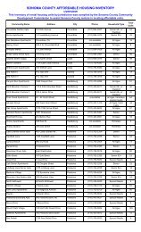
Slusser Rd<br />
Flood-Prone Urban Area<br />
Windsor<br />
River Rd<br />
KÍ<br />
Mark West Creek<br />
Mark West Springs Rd<br />
Old Redwood Hwy<br />
Riebli Rd<br />
The Flood-Prone Urban Area (FPUA) was<br />
established by Ordinance No. 4467 and contains<br />
many problematic drainage areas caused by flat<br />
topography and backwater effects from the Laguna<br />
de Santa Rosa. Therefore, any fill placed in the<br />
FPUA requires a grading permit with plans and<br />
specifications prepared by a civil engineer. An<br />
engineering analysis is also required to<br />
demonstrate no adverse impact to drainage within<br />
the FPUA will result from the fill placement and<br />
related improvements.<br />
Rincon Creek<br />
Wallace Rd<br />
Baird Rd<br />
Laguna Rd<br />
Olivet Rd<br />
Willowside Rd<br />
Guerneville Rd<br />
Fulton Rd<br />
Piner Rd<br />
Mendocino Ave<br />
Santa Rosa<br />
Brush Creek Rd<br />
?Ý<br />
Ducker Creek<br />
Frei R d<br />
Hall Rd<br />
W College Ave<br />
S anta Rosa Creek<br />
College Ave<br />
4th St<br />
Spring Creek<br />
W 3rd St<br />
Sebastopol Rd<br />
Matanzas Creek<br />
Bennett Valley Rd<br />
?Ü<br />
High School Rd<br />
Occidental Rd<br />
?Ý<br />
Text<br />
S Wright Rd<br />
Hearn Ave<br />
Atascadero Creek<br />
Bodega Hwy<br />
Sebastopol<br />
Laguna De Santa Rosa<br />
Ludwig Ave<br />
Bellevue Ave<br />
KÍ<br />
Llano Rd<br />
Water Troug h Rd<br />
Todd Rd<br />
Mountain View Ave<br />
Flood-Prone Boundary<br />
Lone Pine Rd<br />
Blucher Creek<br />
Laguna de Santa Rosa<br />
(F1 and F2 - Not Displayed in City Limits)<br />
Rivers<br />
Highways<br />
?Ü<br />
Stony Point Rd<br />
Five Creek<br />
Hinebaugh Creek<br />
Snyder Ln<br />
Rohnert Park<br />
Copeland Creek<br />
Crane Creek<br />
E Cotati Ave<br />
Petaluma Hill Rd<br />
Major Roads<br />
Ê<br />
0 4,000 8,000<br />
Feet<br />
1:96,000<br />
Roblar Rd<br />
W Sierra Ave<br />
Old Redwood Hwy<br />
Cotati<br />
Ro berts Rd<br />
Lichau Creek<br />
Map Scale and Reproduction methods limit precision in physical features displayed. This map<br />
is for illustrative purposes only, and is not suitable for parcel-specific decision making. Sitespecific<br />
studies are required to draw parcel-specific conclusions.<br />
No part of this map may be copied, reproduced, or transmitted in any form or by any means<br />
without written permission from the <strong>Permit</strong> and Resource Management Department (PRMD),<br />
<strong>County</strong> of <strong>Sonoma</strong>, California. Maps contained in a planning document published by PRMD<br />
can be photocopied by members of the public for review and comment purposes.<br />
<strong>Sonoma</strong> <strong>County</strong><br />
<strong>Permit</strong> and Resource Management Department<br />
2 5 5 0 V e n t u r a A v e n u e , S a n t a R o s a , C a l i f o r n i a 95403<br />
707-565-1900 FAX 707-565-1103<br />
Author: PRMD Cartography: N. Najarian File No.: S:\GIS-DATA\PRMD_BASE\PRMD Department Projects\Engineering\Flood Prone Urban Area - A Size.mxd Date:01/18/2008