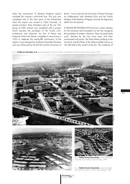
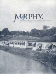
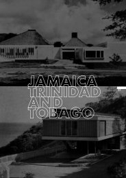
when the construction of General Andrews airport mutilated this avenue’s north-south line. This axis was completed only in the final years of the dictatorship when the airport was moved to Cabo Caucedo, its present location, thirty kilometers east of the city. This group of traffic arteries was completed with a project which became the paradigm of the Trujillo era’s architecture <strong>and</strong> urbanism: the Fair of Peace <strong>and</strong> Fraternity of the Free World, completed in record time in 1955 to celebrate the twenty-fifth anniversary of the regime. It was designed by Guillermo González Sánchez <strong>and</strong> was influenced by the EUR 42 <strong>and</strong> the University of Rome. 12 Caro’s plan for the University of <strong>Santo</strong> <strong>Domingo</strong> (in collaboration with Humberto Ruiz <strong>and</strong> the French designer of the Basilica of Higuey, Dunoyer de Segonzac) dates from this period. IT SHOULD BE POINTED OUT that Caro’s urban schemes for the University <strong>and</strong> González’s for the Fair recognize the postulates of modern urbanism. They are particularly axial, defined by the two main axes with their monumental end points, the Alma Mater building at the University <strong>and</strong> the Plaza of the Nations (better known as ‘the little ball of the world’) at the fair. The modernity of Fig. 3. Guillermo González et al, aerial photography of the Fair of Peace <strong>and</strong> Fraternity of the Free World, <strong>Santo</strong> <strong>Domingo</strong>, 1955 55 © photo Stopelman Fig. 4. Rafael Tomás Hernández, urban development of the barrio de Honduras, <strong>Santo</strong> <strong>Domingo</strong>, 1966 Fig. 5. Rafael Tomás Hernández, urban development of the barrio del Hoyo de Chulín, <strong>Santo</strong> <strong>Domingo</strong>, 1988 Docomomo N°33 September 2005
56 these ensembles is seen in the design of their buildings <strong>and</strong> in their urban installations, but not in their conception of space or their management of vehicular traffic. Trujillo compromised Dominican modernity when he commissioned a catalogue of works representing the regime throughout the country. Gázon Bona created a ‘Trujillista’ typology of Dominican architecture in a series of projects in San Cristobal, where he built hotels, housing projects <strong>and</strong> schools; in Santiago with his Monument to Peace of Trujillo <strong>and</strong> dozens of ‘palaces;’ <strong>and</strong> in the frontier region where he designed hotels, barracks, municipal government buildings, law courts <strong>and</strong> branch offices of the Dominican party. <strong>Santo</strong> <strong>Domingo</strong> never had a structured vision of a modern city (or to be exact, of any kind of city), unlike Cuba during Machado’s dictatorship, for whom Forestier worked, as he also did in Argentina. 13 In reality, the city’s urban project appears to be only the sum of independent <strong>and</strong> punctual works, linked to the city to optimize <strong>and</strong> adapt it to the new times without touching to the historical center, as José Lluís Sert proposed for Havana in 1959. 14 The architect Ramón Vargas Mera, author of the Regulating Plan for <strong>Santo</strong> <strong>Domingo</strong> in 1956 recognized a bit of this when he wrote: “Demolishing the historical center <strong>and</strong> building towers in its place is not what is proposed. The center is to be respected, with its architectural <strong>and</strong> urban values.” 15 Vargas Mera was the only one to dem<strong>and</strong> a vision of a modern city for <strong>Santo</strong> <strong>Domingo</strong>. Nevertheless, his vision questioned orthodox modern urbanism, as he noted when writing about the plan: “The system of zoning according to function, central to the CIAM <strong>and</strong> the Athens Charter, is to be substituted by a system of mixed zoning in which the predominant activity will stimulate the character of the zone <strong>and</strong> secondary activities will complement the zone’s use.” 16 The fact that Vargas Mera’s plan was rejected, once it conflicted with the regime’s political interests, reaffirmed the refusal of political will to conceive of the city as an integrated whole. This attitude continues today. AFTER THE FALL of the Trujillo regime in 1961, <strong>Santo</strong> <strong>Domingo</strong> recovered its name <strong>and</strong> became an open city which continues to enforce its vision of modernity. However, it has still not drawn up a master plan, <strong>and</strong> we continue to hope to see it converted into a better city. Although modernism was practiced during the Trujillo era, a modern city, participatory, functional <strong>and</strong> democratic, remains to be constructed. Joaquín Balaguer, elected president with the support of the invading troops of the Organization of American States, was more interested in the colonial city, bad housing <strong>and</strong> large parks. Nor have subsequent governments really involved themselves in the city. And so, after five centuries, <strong>Santo</strong> <strong>Domingo</strong>, lying by the Ozama River, still awaits a contemporary identity, which has yet to arrive. OMAR RANCIER, architect, graduated cum laude from the University Autónoma of <strong>Santo</strong> <strong>Domingo</strong> in 1979. President <strong>and</strong> founder of the group Neuvarquitectura, organizer of architectural biennials in <strong>Santo</strong> <strong>Domingo</strong>, author of numerous articles <strong>and</strong> essays in <strong>Santo</strong> <strong>Domingo</strong>'s major specialist journals, professor at the school of architecture at the University Pedro Henríquez Ureña (UNPHU). Omar Rancier was also director of the Faculty of Architecture at the University Iberoamericana (UNIBE). Translated by Jon Kite NOTES 1 Colin Rowe, Fred Koeter, Ciudad Collage (Barcelona: GG, 1981), 34. 2 Eugenio Pérez Montas, La Ciudad del Ozama (Barcelona: Patronato de la Ciudad Colonial de <strong>Santo</strong> <strong>Domingo</strong> & Centro de Altos Estudios Humanísticos y del Idioma Español, 1999), 284. 3 Ibid., 283. Taken from J. Chez Checo, El Palacio Nacional de la República Dominicana: 50 Años de historia y arquitectura (<strong>Santo</strong> <strong>Domingo</strong>: Secretaria Administrativa de la Presidencia, 1997). 4 Virgilio Vercelloni, Atlas Histórcio de <strong>Santo</strong> <strong>Domingo</strong> (Milan: Cosmopoli, 1991). 5 Architect Ramón Martinez, “El Significado de la Arquitectura de la Era de Trujillo,” paper presented at Arquitectura Contemporanea en la República Dominicana, organized by the Grupo Nuevarquitectura (Casa de Teatro, September 4–6, 1981). 6 “In its time, by which it was inspired, the typical neoclassicism was born, which was extremely characterized by its lines. These limpid creations resemble a past overflowing with tradition <strong>and</strong> nationality.” Henry Gazón Bona, La Arquitectura Dominicana en la Era de Trujillo (Collection Henry Gazón Bona, 1949), 1. 7 Architect Ramón Martinez, “El Significado de la Arquitectura de la Era de Trujillo,” paper presented at Arquitectura Contemporanea en la República Dominicana, organized by the Grupo Nuevarquitectura (Casa de Teatro, September 4–6, 1981). 8 Omar Rancier, “Versatilidad estilistica en la Arquitectura de Guillermo González,” Nuevarquitectura 43, El Siglo (February 23, 1990): 6B. 9 Silvia Hernández de Lasala, Malaussena: Arquitectura Academica en la Venezuela Moderna (Caracas: Editorial ExLibris, 1990), 20. 10 Leonardo Benevolo, Historia de la Arquitectura Moderna (Barcelona: Gustavo Gili, 1982), 100. 11 Engineer José R. Báez López-Penha, “<strong>Santo</strong> <strong>Domingo</strong>: Su Fundación y Crecimiento,” paper presented at the round table on urban planning (National University Pedro Henriquez Ureña, July 6–8, 1972). Codia 26, May/August 1971. 12 Gustavo Luis Moré, “Guillermo González: A los 82 años de su nacimiento,” Hoja de Arquitectura 26, “El Nuevo Diario” (November 1, 1982). 13 Jean-François Lejeune, “The City as L<strong>and</strong>scape: Jean Claude Nicolas Forestier <strong>and</strong> the Great Urban Works of Havana, 1925–1930,” The Journal of Decorative <strong>and</strong> Propag<strong>and</strong>a Arts 22 (Cuba, 1996): 165. 14 Mario Coyula, “Influencias Cruzadas Cuba/EUU en el medio construido: Carril dos, o autopista en dos sentidos?,” Archivos de Arquitectura Antillana, Year 5, No. 10 (June 2000): 121. 15 Ramón Vargas Mera, “Tendencias Urbanisticas in America Latina y el Caribe: La Situacion a Finales del Siglo XX,” Amigo del Hogar (<strong>Santo</strong> <strong>Domingo</strong>, 2004): 73. 16 Ibid. Docomomo N°33 September 2005