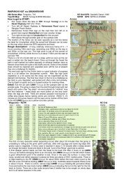
WHIRINAKI TRACK - Taupo Tramping Club
WHIRINAKI TRACK - Taupo Tramping Club
WHIRINAKI TRACK - Taupo Tramping Club

Create successful ePaper yourself
Turn your PDF publications into a flip-book with our unique Google optimized e-Paper software.
<strong>Taupo</strong> <strong>Tramping</strong> <strong>Club</strong> – <strong>Tramping</strong> Notes by Austin Hutcheon Version: 27 July 2006<br />
MOUNT TIHIA<br />
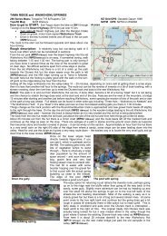
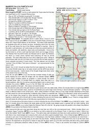
Map: Tongariro, 1:50,000 T19, refer Figures 1, 3 and 4<br />
GPS: Geodetic Datum 1949 – refer Figures 5a (Geographic) and 5b (NZ Grid)<br />
How to get to START:<br />
Figure 1<br />
Access to the Start of the Walk and Map Sheets<br />
• Exit <strong>Taupo</strong> down the lake on SH1 to<br />
Turangi<br />
• Turn right off SH1 onto SH41<br />
towards Tokaanu<br />
• Turn left off SH41 onto SH47 as if<br />
going to Whakapapa – set your trip<br />
meter<br />
• Look for small car park on RHS of<br />
road at 4.5km from Junction (WP2)<br />
• There is space for about 3 cars here<br />
so park in tidy manner as far off<br />
asphalt as possible<br />
Rough description: An easy to moderate walk through very thick bush in parts and with somewhat of a steep start<br />
from a car park at the side of SH47 only a few kilometres out of Turangi. The lower part is a bit steep as noted and is<br />
through thick broadleaf forest with very active birdlife – including Tui. Further up one crosses the line of the Tokaanu<br />
Tunnel then emerges from forest into rather high bush – which is a struggle for the vertically challenged. To the point<br />
reached and the walk aborted due to weather conditions the overall altitude gain was a bit over 500 metres. In mid July<br />
2005 the walk had to be abandoned after 90 minutes due to low cloud and high winds.<br />
Detail: Drive out of Turangi on the<br />
Tokaanu Road (SH41) then turn off left<br />
onto the road for Whakapapa (SH47) and<br />
continue up SH47 for 4.5km when you<br />
should see a small car parking area on<br />
the right hand side of the road as you go<br />
up. Park here, but well off the road.<br />
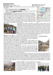
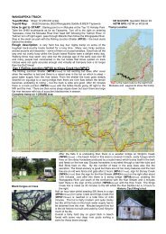
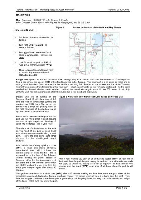
Figure 2 View from WP8 North over Lake <strong>Taupo</strong> on Cloudy Day<br />
Buried in the trees on the edge of this car<br />
park you will find a small footpath leaving<br />
the road at right angles and heading off<br />
uphill into the forest – this is your route.<br />
There is a bit of a brutal start to this walk<br />
as you head off up quite a steep slope<br />
without any warm-up wander along a level<br />
path. There are also some quite large<br />
step-ups for the short-legged Hobbit<br />
tramper.<br />
After 20 minutes of steep uphill you cross<br />
(WP4) a level, over-grown, obviously<br />
man-cleared area which follows the<br />
contour along or round the hill – this is<br />
assumed to be the line of the Tokaanu<br />
Tunnel feeding the power station in<br />
Tokaanu. After this the slope eases a bit<br />
but there are a few wind-fall trees which<br />
are slightly awkward to get over then the<br />
slope gets steeper again after about 40<br />
minutes.<br />
After 1 hour walking you start on an undulating section (WP6) or ridge still in<br />
the forest then the path is quite deeply incised and runs with water on really<br />
wet days, so watch you footing as it can be slippery. In 1:05 minutes you<br />
emerge from the forest (WP7) to an area of tall bush where the path is still<br />
incised.<br />
You get into lower bush on a minor crest (WP8) after 1:15 minutes walking and from here there are good views of the<br />
mountains (on a good day) and of Turangi plus Lake <strong>Taupo</strong>. The picture used in Figure 2 is taken from this spot. From<br />
here the struggle continues upwards on quite a gentle slope but the going is not too easy due to the density and height<br />
of the bush – make sure you follow the path.<br />
Mount Tihia Page 1 of 2
<strong>Taupo</strong> <strong>Tramping</strong> <strong>Club</strong> – <strong>Tramping</strong> Notes by Austin Hutcheon Version: 27 July 2006<br />
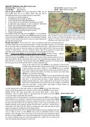
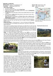
Figure 3 Extract of Map with GPS Track<br />
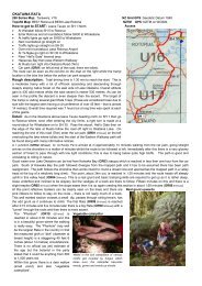
Figure 4 Extract of Map with Critical Waypoints<br />
The track followed shown as a green line in Figure 3<br />
All the waypoints taken are shown in Figure 5 and a selection of<br />
these are shown above in Figure 4 – they are seen as numbered<br />
rectangles on the map.<br />
Figure 5a GPS Waypoint Data – Geographic format On the day this walk was done<br />
the weather proved the winner<br />
and express train speed winds,<br />
low cloud and rain necessitated<br />
aborting and retreating back<br />
down the path used on the way<br />
up.<br />
On the way down a Tui,<br />
seemingly feeding on red<br />
berries form a Miro serenaded<br />
the walkers all the way.<br />
Figure 5b GPS Waypoint Data – NZ Grid format It is possible to do a circular<br />
walk and return to SH47 further<br />
along the highway towards<br />
Whakapapa – this section of<br />
the walk will be added in due<br />
course when records are<br />
collected, that is when the<br />
weather is kinder to trampers<br />
and the wind does not blow us<br />
off the hill.<br />
Notes:<br />
Garmin Summit GPS on Geodetic datum 1949 with suspect signal in places due to forest cover<br />
WP = Waypoint as taken by GPS unit<br />
masl = metres above sea level (as recorded by GPS unit and may not agree exactly with map spot heights)<br />
Mount Tihia Page 2 of 2