The Thought Processes of a Weather Forecast, Illustrated with Case ...
The Thought Processes of a Weather Forecast, Illustrated with Case ...
The Thought Processes of a Weather Forecast, Illustrated with Case ...

You also want an ePaper? Increase the reach of your titles
YUMPU automatically turns print PDFs into web optimized ePapers that Google loves.
european 2013 v40 pages:European<strong>Forecast</strong>er13 10/06/13 12:26 Page 31<br />
<strong>The</strong> <strong>Thought</strong> <strong>Processes</strong> <strong>of</strong> a <strong>Weather</strong> <strong>Forecast</strong>,<br />
<strong>Illustrated</strong> <strong>with</strong> <strong>Case</strong> Studies<br />
Jean Neméghaire, Royal Meteorological Institute <strong>of</strong> Belgium (RMIB),<br />
Uccle (Belgium)<br />
Introduction<br />
Over the last decades more and more raw data are<br />
disseminated to forecasters. <strong>The</strong>se data are usually<br />
<strong>of</strong> high quality and are becoming accessible more<br />
rapidly to forecasters, who have to examine this<br />
information a very short time.<br />
Frequent and increasingly sophisticated observations<br />
are available and displayed on workstations,<br />
such as different RGB combinations <strong>of</strong> MSG satellite<br />
channels, radar, lidar and lightning products. More<br />
and more raw data from high resolution models<br />
(both global and limited area) and Ensemble<br />
Prediction Systems (EPS) are also accessible at<br />
least twice a day. And 'mixed tools' like the INCA<br />
and SAF applications are being developed, computing<br />
more surface parameters mostly for analysis<br />
and nowcasting.<br />
At the same time, forecasters - trained in the field <strong>of</strong><br />
observations and the prediction <strong>of</strong> weather phenomena<br />
- are thinking in terms <strong>of</strong> meteorological objects<br />
and conceptual models. <strong>The</strong>y are selecting and identifying<br />
the main dynamical and physical processes<br />
at synoptic and sub-synoptic scales relevant to these<br />
weather phenomena.<br />
<strong>Forecast</strong>ers' Tasks for Nowcasting<br />
and Short Range <strong>Forecast</strong>s<br />
1. Scales<br />
Firstly, the appropriate spatial and time scales have<br />
to be considered depending on the weather situation<br />
and on the range <strong>of</strong> forecasts:<br />
• for Nowcasting, analysis and forecasts for the next<br />
one to three hours are made in a small domain<br />
centred over Belgium<br />
• for Short Range forecasts we usually consider<br />
Western Europe and near ocean areas around<br />
Belgium, and over the next forty-eight hours<br />
2. Diagnosis: Selection <strong>of</strong> Meteorological<br />
Fields Appropriate to the <strong>Weather</strong> Situation<br />
A high resolution diagnosis is made, based on a<br />
selection <strong>of</strong> raw meteorological data from numerical<br />
models and verified in real time against observations<br />
. This selection needs to be as closely suited<br />
as possible to a realistic description <strong>of</strong> the current<br />
weather situation. In some cases forecasters cannot<br />
identify clear-cut meteorological objects in their<br />
analysis, <strong>with</strong> no clear-cut characterised fields associated<br />
<strong>with</strong> conceptual models.<br />
One <strong>of</strong> the major challenge for forecasters is to<br />
reconcile both the input <strong>of</strong> raw data (from observations<br />
and numerical models) and the conceptual<br />
model approach (physical and dynamical processes)<br />
to build a realistic three-dimensional image (the<br />
diagnosis) <strong>of</strong> the weather situation and arrive at a<br />
good guideline for its short term evolution (the<br />
prognosis).<br />
In the following paragraphs we will briefly illustrate<br />
the main thought processes employed by forecasters<br />
for their analysis and short range forecasts.<br />
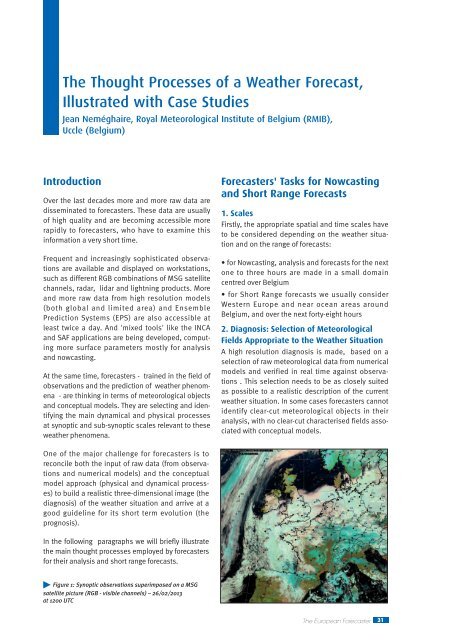
Figure 1: Synoptic observations superimposed on a MSG<br />
satellite picture (RGB - visible channels) – 26/02/2013<br />
at 1200 UTC<br />
<strong>The</strong> European <strong>Forecast</strong>er 31
european 2013 v40 pages:European<strong>Forecast</strong>er13 10/06/13 12:26 Page 32<br />
Illustration : the <strong>Weather</strong> Situation on 26 th February<br />
2013 at 1200 UTC<br />
A large and rather homogeneous low cloud pattern<br />
embedded in a moderate and cold northeasterly<br />
airstream is observed over Western Europe. Snow<br />
cover can also be detected in many areas (figure 1).<br />
<strong>The</strong> ECMWF model analysis at the same date simulates<br />
this (low) cloud pattern in a realistic way<br />
(figure 2). It shows that this weather situation is<br />
characterized by low level mixing in a cold and relatively<br />
humid airmass and not by clear-cut frontal<br />
systems.<br />
For this diagnosis a detection <strong>of</strong> the altitude <strong>of</strong> the<br />
(local) mixing layer can be very relevant (figure 3)<br />
3. Prognosis : Interpreting Selected Fields to<br />
Identify a Most Likely Scenario<br />
A realistic analysis is essential in order to derive a<br />
most likely weather scenario. A further interpretation<br />
<strong>of</strong> the selected data is achieved coupling the<br />
evolution at relevant upper-air and near surface<br />
levels and comparing it <strong>with</strong> different high resolution<br />
Global and LAM models. Additional raw data,<br />
possibly from EPS systems, can also be interpreted<br />
depending on the evolution <strong>of</strong> the weather situation.<br />
An adaptation <strong>of</strong> the simulated physical and<br />
dynamical processes is made to forecast local<br />
sensible weather parameters and their uncertainties<br />
over the targeted area.<br />
Illustration: the Short Term <strong>Weather</strong> <strong>Forecast</strong> From<br />
the 26 th to 27 th February 2013<br />
<strong>Forecast</strong>ers examined the following meteorological<br />
fields issued from the ECMWF model (shown in<br />
figures 4 and 5):<br />
• the low cloud pattern circulates on the southern<br />
flank <strong>of</strong> a high pressure area centred over the north <strong>of</strong><br />
British, Isles<br />
Figure 2: ECMWF analysis for the same time (26/02/2013<br />
at 1200 UTC) (up) MSLP and total cloud, (down) cloud base<br />
height fields (white
european 2013 v40 pages:European<strong>Forecast</strong>er13 10/06/13 12:26 Page 33<br />
4. <strong>Forecast</strong> Products<br />
<strong>Forecast</strong>ers found their decisions on their most likely<br />
weather scenario, taking the uncertainties into<br />
account and also based on discussions <strong>with</strong> their<br />
colleagues. <strong>The</strong>y make a synthesis <strong>of</strong> these thinking<br />
Figure 5: MSLP, 2m Temperature and 10m Wind forecast on<br />
the 27 th at 0000 (up) and 1200 (middle) UTC and the 28 th<br />
at 0000 UTC (down)<br />
Figure 4: MSLP and Low Cloud pattern forecast on the 27 th<br />
at 0000 (up) and 1200 (middle) UTC and the 28 th<br />
at 0000 UTC (down)<br />
<strong>The</strong> European <strong>Forecast</strong>er 33
european 2013 v40 pages:European<strong>Forecast</strong>er13 10/06/13 12:26 Page 34<br />
processes in a short weather forecast report consistent<br />
<strong>with</strong> most representative meteorological fields <strong>of</strong><br />
selected meteorological objects (the conceptual<br />
model approach) and/or forecast sensible weather<br />
parameters.<br />
Figure 7: MSLP, 2m Temperature and 10m Wind forecast<br />
for the 27 th at 0000 (up) and 1200 (middle) UTC and the 28 th<br />
at 0000 UTC (down)<br />
Figure 6: MSLP and Low Cloud pattern forecast for the 27 th<br />
at 0000 (up) and 1200 (middle) UTC and the 28 th at 0000 UTC<br />
(down).<br />
34<br />
<strong>The</strong> European <strong>Forecast</strong>er
european 2013 v40 pages:European<strong>Forecast</strong>er13 10/06/13 12:26 Page 35<br />
Figure 8: MSLP and 3 hour accumulated snow fields from<br />
ECMWF model forecast (up) – ALARO 7km forecast (down)<br />
5. Warnings<br />
More exchanges and discussions on a most likely<br />
weather scenario are needed to issue (very) short<br />
term warnings. <strong>Forecast</strong>ers have to refine their<br />
weather scenario at smaller scales to communicate<br />
<strong>with</strong> authorities and media. At this step exchanges<br />
<strong>of</strong> warnings between neighbouring countries are<br />
very welcome to harmonize the different weather<br />
scenarios and facilitate the communication to users.<br />
Illustration : Snow forecasts for the case study <strong>of</strong> the<br />
5 th <strong>of</strong> March 2012 at 0900 UTC<br />
In Figure 8 we compare the 3 hour snow amount<br />
(between 0300 and 0600 UTC)<br />
issued from the ECMWF and ALARO 7km models.<br />
In figure 9 the area <strong>of</strong> snow forecast by INCA-<br />
Belgium on the 5 th at 0900 UTC is coloured in blue<br />
(<strong>with</strong> rain in beige and rain+snow in green)<br />
Concluding Remarks<br />
<strong>The</strong> importance <strong>of</strong> a realistic diagnosis has been<br />
underlined. It is an essential step in the thought<br />
processes <strong>of</strong> forecasters building their 3D image <strong>of</strong><br />
the weather situation - where the main dynamical<br />
and physical processes are involved, along <strong>with</strong><br />
verifying the model outputs in real time. <strong>Thought</strong><br />
processes are very useful for non-severe weather<br />
situations (such as shown in case study <strong>of</strong> the 26 th<br />
February 2013) as well as for more severe ones (as<br />
in the case study <strong>of</strong> the 5 th March 2012).<br />
From this diagnosis forecasters can derive more<br />
easily and consistently a most likely weather<br />
scenario coupling upper-air and near surface meteorological<br />
fields selected from models. Currently,<br />
EPS systems (like GLAMEPS proposed for our<br />
national meteorological service in Belgium) are not<br />
yet fully exploited for short term forecasts and so<br />
the short term weather scenario may appear too<br />
deterministic.<br />
<strong>The</strong> expertise <strong>of</strong> forecasters is certainly needed to<br />
adapt their most likely weather scenario for their<br />
areas, and to refine their forecasts <strong>of</strong> the sensible<br />
weather parameters and uncertainties.<br />
Figure 9: Precipitation phase forecast <strong>with</strong> the INCA-BE<br />
system (where observation are mixed <strong>with</strong> the HR LAM model<br />
ALARO 4km)<br />
<strong>The</strong> objective <strong>of</strong> thought processes is for forecasters<br />
to develop a more comprehensive approach, helping<br />
them to decide, report and communicate more<br />
appropriately their products to authorities, media<br />
and specific users.<br />
<strong>The</strong> European <strong>Forecast</strong>er 35