PROBLEMS OF CLASSIFYING SOILS WITH ... - ROOT of content
PROBLEMS OF CLASSIFYING SOILS WITH ... - ROOT of content
PROBLEMS OF CLASSIFYING SOILS WITH ... - ROOT of content

Create successful ePaper yourself
Turn your PDF publications into a flip-book with our unique Google optimized e-Paper software.
<strong>PROBLEMS</strong> <strong>OF</strong> <strong>CLASSIFYING</strong> <strong>SOILS</strong> <strong>WITH</strong><br />
SULFIDIC HORIZONS IN PENINSULAR<br />
MALAYS IA<br />
S. Paramananthan<br />
Department <strong>of</strong> Agriculture<br />
Peninsular Malaysia, and<br />
B. Gopinathan<br />
Malaysian Agricultural Research and Development Institute<br />
Serdang, Selangor, Malaysia<br />
1 Summary<br />
An acid sulfate soil sequence developed on coastal clay soils in<br />
Peninsular Malaysia is described. Soil ripening after the construction<br />
<strong>of</strong> bunds and drains has resulted in the development <strong>of</strong> sulfuric and cambic<br />
horizons. The underlying material is commonly sulfidic. Two similar<br />
sequences are recognized, one on marine alluvium, and the other on<br />
brackish water deposits. The latter is characterized by higher organic<br />
matter <strong>content</strong>. The problems associated with mapping and classification<br />
are noted, and changes in the Soil Taxonomy to cater €or the anomalies<br />
are proposed.<br />
2 Introduction<br />
Peninsular Malaysia is situated between latitudes lo 13" and Ï'ON and<br />
longitudes 99'E and 104' 20'E. The physical relief is dominated by the<br />
Central Mountain Range which runs nearly through the middle <strong>of</strong> the<br />
Peninsula. The west coast is dominated by clayey deposits <strong>of</strong> marine and<br />
brackish water origin, while the east coast is dominated by sandy beach<br />
ridges. This difference in geomorphology is attributed to the calm seas<br />
<strong>of</strong> the Straits <strong>of</strong> Malacca <strong>of</strong>f the west coast and the relatively turbulent<br />
South China Sea <strong>of</strong>f the east coast.<br />
The coastal clays extend as an almost continuous block along the west<br />
coast and is only broken by occasional islands <strong>of</strong> sedimentary and<br />
96
igneous rocks. The coastal plain varies in width from about 10 km to 50<br />
km. The eastern boundary <strong>of</strong>ten grades into peat swamps. The coastal<br />
plain which averages in height from 0-15 m above mean sea level is extensively<br />
used for agriculture. The agricultural development which began<br />
in the early part <strong>of</strong> this century has been made possible by the construction<br />
<strong>of</strong> a coastal bund to keep out inundation by sea water and the<br />
reclamation <strong>of</strong> these areas by drainage. Rice, rubber, oil palm, coconut,<br />
cocoa and c<strong>of</strong>fee are the main crops cultivated on these reclaimed areas.<br />
This paper deals mainly with the soils which were developed when large<br />
parts <strong>of</strong> this coastal plain were bunded and drained for the cultivation<br />
<strong>of</strong> perennial crops.<br />
3 Literature Review<br />
Prior to the reconnaissance soil survey <strong>of</strong> Peninsular Malaysia, very<br />
little was known about the coastal clay soils. Dennet (1933) recognized<br />
that soils with high concentrations <strong>of</strong> acid were associated with the<br />
nipah palm, and Wilshaw (1940) reports the occurrence <strong>of</strong> acid conditions<br />
on draining coastal soils. Coulter (1952) referred to soils containing<br />
considerable amounts <strong>of</strong> pyrite as gelam (MeZaZeuca leucodendron) soils.<br />
A mixture <strong>of</strong> circumstantial and intrinsic soil properties was originally<br />
used to distinguish potential and actual acid sulfate soils from soils<br />
not showing or not expected to develop extreme acidity on drainage and<br />
cultivation. Systematic development <strong>of</strong> morphometric criteria started<br />
around 1967 on the basis <strong>of</strong> experience in comparable tropical countries<br />
when the term 'cat clay' or acid sulfate layer as a diagnostic horizon<br />
definei tentatively as one with a pH <strong>of</strong> about 3.3 or less on the air drysoil<br />
and a soluble sulfate <strong>content</strong> in the air dried soil exceeding 0.1<br />
percent was introduced. The morphometric criteria proposed by Soil Taxonomy<br />
(USDA 1974) for sulfidic materials and sulfuric horizons were<br />
tested for Malaysian conditions since 1973 using the earlier drafts <strong>of</strong><br />
Soil Taxonomy when systematic detailed mapping <strong>of</strong> the coastal plain was<br />
initiated by the Soil Survey Section <strong>of</strong> the Department <strong>of</strong> Agriculture in<br />
West Johore. These studies (Gopinathan 1973, Joseph and Maar<strong>of</strong> 1975,<br />
Paramananthan 1976) made it possible to recognize sequences <strong>of</strong><br />
97
4 Pr<strong>of</strong>ile Development<br />
On ripening, the alluvial deposits give rise to the development <strong>of</strong> cambic<br />
or sulfuric horizons with a moderately developed structure and In1<br />
values < 0.7. Straw-yellow jarositic mottles with hue 2.5 or yellower<br />
and chroma <strong>of</strong> 6 or more are <strong>of</strong>ten seen together with strong brown (7.5YR<br />
5/6-5/8) and brownish yellow (IOYR 6/6-6/8) mottles, particularly on<br />
brackish water deposits, which normally have a high organic matter <strong>content</strong>.<br />
The brown mottles tend to dominate in the upper part <strong>of</strong> the diagnostic<br />
horizon, the straw-yellow in the lower part, the latter <strong>of</strong>ten being<br />
associated with old root channels. This distribution pattern is most<br />
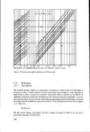
obvious in Sulfic Tropaquepts like Tongkang A (Figure 1). The cambic or<br />
sulfuric horizon is normally underlain by a sulfidic C-horizon with Inr<br />
values > 0.7, greenish gray (5GY 6/1) OK dark blue (5B 5/1) in colour<br />
and with many decomposing pieces <strong>of</strong> wood and old root channels, through<br />
which water flows easily. Depth <strong>of</strong> the sulfidic C-horizon ranges from<br />
less than 50 cm to more than 1 meter.<br />
5 Mapping and Classification<br />
Identification <strong>of</strong> cambic horizons in the field is normally no problem;<br />
neither is the determination <strong>of</strong> their pH OK the recognition <strong>of</strong> jarositic<br />
mottles. Identification <strong>of</strong> sulfidic soil material, however, remains a<br />
practical difficulty as it requires laboratory determinations <strong>of</strong> at<br />
least pH <strong>of</strong> fresh and incubated samples (Powlson 1976) and preferably,<br />
determination <strong>of</strong> total sulfur. This difficulty complicates identification<br />
<strong>of</strong> superficially developed soils in all clayey alluvial parent<br />
material but it can be overcome by organizational methods, and identification<br />
and delineation <strong>of</strong> mapping units henceforth can proceed as a routine<br />
operation, once locally applicable field criteria have been defined<br />
for the recognition <strong>of</strong> potential acid sulfate soil horizons.<br />
Difficulties <strong>of</strong> a more fundamental nature need to be overcome when one<br />
tries to correlate mapping units based on local and practical distinguishing<br />
criteria, with a world-wide soil classification system, viz.<br />
Soil Taxonomy, which strives to express distinguishing criteria <strong>of</strong> general<br />
genetic significance. Acid sulfate soils are anomalous in the sense<br />
99
that their intensive and rapid chemical dynamics may overrule the more<br />
slowly developing properties which are normally accepted as parameters<br />
for soil development. In Soil Taxonomy the cambic horizon, which normally<br />
is the main diagnostic horizon for the Inceptisols has been overruled<br />
in acid sulfate soils by the sulfidic subsoil where its upper limit occurs<br />
within 50 cm. The sulfidic material derives its importance from its<br />
chemical acidifying potential, to which the genetic significance <strong>of</strong> the<br />
cambic horizon has been sacrificed in this case. In Malaysia several<br />
soil series are recognized with sulfidic materials within 50 cm but<br />
overlain by well developed cambic and/or sulfuric horizons e.g. Sekat<br />
series, Sedu A series (Figure I). With the present definitions these<br />
soil series would partly fit into Typic Sulfaquents, and partly into the<br />
Typic Sulfaquepts, although for practical and genetic reasons they are<br />
similar, and very different from Typic Sulfaquents without a cambic horizon<br />
such as the Linau series. Therefore it does not appear logical to<br />
separate them at the order level. A better solution would be to recognize<br />
the sulfidic soil material as an indicator <strong>of</strong> potential acidity, ds<br />
a secondary diagnostic horizon for the distinction <strong>of</strong> classes at the<br />
subgroup level analogous to the sulfuric horizon, which is subordinate<br />
to the cambic horizon in Soil Taxonomy.<br />
With this status also the presence <strong>of</strong> sulfidic material between 50 cm<br />
and 100 cm in Inceptisols without a clear sulfuric horizon, could be<br />
given due recognition. With the present criteria such soils are classified<br />
as Typic Tropaquepts, e.g. Jawa B and Tongkang B in Figure I .<br />
Hence the authors propose that a sulfidic subgroup be established to indicate<br />
soils having a cambic horizon overlying sulfidic material within<br />
1 meter. The above mentioned Jawa B and Tongkang B series would thus be<br />
classified as Sulfidic Tropaquept. Soils with sulfidic material within<br />
50 cm but overlain by a well developed cambic and/or sulfuric horizons<br />
would then fall into the Sulfidic Tropaquepts and Typic Sulfaquepts respectively<br />
(Figure 2).<br />
1 O0
A<br />
A<br />
0<br />
0<br />
C<br />
C<br />
Taxonomy<br />
Typic Sulfaquent Typic Tropoquept<br />
Typic Sulfaquent<br />
posed Changes<br />
Typic Sulfaquept Sulfidic Tropaquept Sulfidic Tropaquept<br />
1 I I I<br />
NOTE:-<br />
11//1 Jarosite Mottles<br />
ure 2. Pr<strong>of</strong>ile morphology to illustrate proposed changes in the Soil<br />
onomy<br />
Acknowledgement<br />
! authors wish to thank the Director Generals <strong>of</strong> the Department <strong>of</strong><br />
,iculture and MAl2DI for their permission to present this paper.<br />
101
References<br />
Coulter, J.K. 1952. Gelam Soils. Malay. Agric. Journal, Volume 35,<br />
No. 1.<br />
Dennet, J.H. 1933. The classification and properties <strong>of</strong> Malayan Soils.<br />
Malay. Agric. Journal 21, No. 8.<br />
Gopinathan, B. 1973. The semi-detailed soil survey <strong>of</strong> the West Johore<br />
coastal plain. Unpublished report, Department <strong>of</strong> Agriculture, Peninsular<br />
Malaysia.<br />
Joseph, K.T. and N. Maar<strong>of</strong> 1975. A field study showing classical changes<br />
in acidity over large areas in the Parit Jawa area <strong>of</strong> Johore during<br />
the last decade. Proceedings Third ASEAN Soils Conference, p. 383-<br />
391.<br />
Paramananthan, S. 1976. Soils <strong>of</strong> the West Johore area. Soil Correlation<br />
Report No. 111976, Ministry <strong>of</strong> Agriculture and Rural Development,<br />
Malaysia.<br />
Powlson, D.S. 1976. The identification <strong>of</strong> Potential Acid Sulphate Soils.<br />
MARDI Res. Bulletin 4, 1: 34-43.<br />
USDA 1974. Soil Taxonomy. Agriculture Handbook No. 463.<br />
Wilshaw, R.G.H. 1940. Notes on the development <strong>of</strong> high acidity in certain<br />
coastal clay soils <strong>of</strong> Malaya. Malay. Agric. Journal, Volume 28,<br />
No. 8.<br />
1 o2