Dam Monitoring with 3D Tracker GPS - Jewell Instruments
Dam Monitoring with 3D Tracker GPS - Jewell Instruments
Dam Monitoring with 3D Tracker GPS - Jewell Instruments

You also want an ePaper? Increase the reach of your titles
YUMPU automatically turns print PDFs into web optimized ePapers that Google loves.
<strong>Dam</strong> <strong>Monitoring</strong> <strong>with</strong> <strong>3D</strong> <strong>Tracker</strong> <strong>GPS</strong><br />
CASE STUDY<br />
30-SECOND SUMMARY: Libby <strong>Dam</strong> is a straight axis<br />
concrete gravity dam on the Kootenai River approximately 17<br />
miles upstream of Libby, Montana. The dam, constructed in<br />
1961, is part of the Columbia Basin network of dams operated<br />
by the US Army Corps of Engineers Seattle District and is<br />
located upstream of Chief Joseph <strong>Dam</strong>.<br />
SYSTEM CONFIGURATION<br />
In February 2002, the Army Corps completed the installation of a<br />
<strong>3D</strong> <strong>Tracker</strong> real-time <strong>GPS</strong> deformation monitoring system. The<br />
system is comprised of six <strong>GPS</strong> installations spaced across the<br />
crest of the dam <strong>with</strong> two reference stations; one located on a<br />
ridge above the left abutment and a second on a promontory<br />
upstream from the dam at approximately equal elevation <strong>with</strong> the<br />
crest of the dam.<br />
This system configuration allows operators to run multiple<br />
independent processing tasks to each of the remote receivers on<br />
the dam crest while also maintaining reference station integrity<br />
monitoring by running processing tasks between reference<br />
stations.<br />
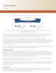
Figure 1. There are 6 <strong>GPS</strong> stations on the crest of Libby<br />
<strong>Dam</strong>. A reference station is located on stable ground on<br />
each side of the dam.<br />
Figure 2. <strong>3D</strong> <strong>Tracker</strong> Screen Shot.<br />
All data is processed in real-time at a PC located in an<br />
instrumentation office at the dam <strong>with</strong> data directly accessible<br />
through WAN connectivity to Corps offices in Seattle. Good sky<br />
visibility at the site, in combination <strong>with</strong> two reference stations,<br />
produces measurement data of approximately 2-4 mm in realtime<br />
and 1-3 mm over a 24-hour period. This data is being used<br />
to compare monitoring results from other conventional<br />
monitoring technologies installed at the dam. These include uplift<br />
pressure cells, plumb lines, joint meters, tiltmeters,<br />
extensometers and inclinometers monitoring rock slide areas on<br />
the left abutment. The <strong>3D</strong> <strong>Tracker</strong> <strong>GPS</strong> system deployed at<br />
Libby was specifically designed to replace a laser alignment<br />
survey which is conducted inside of the dam.<br />
During real-time processing, the <strong>3D</strong> <strong>Tracker</strong> software computes<br />
and displays estimated error envelopes for the current position<br />
solution through the analysis of the current <strong>GPS</strong> satellite<br />
geometry. The error envelopes are representations of a calculated<br />
covariance<br />
<strong>Jewell</strong> <strong>Instruments</strong> LLC, 850 Perimeter Road, Manchester, NH 03103<br />
sales@jewellinstruments.com • www.jewellinstruments.com • Tel (800) 227-5955
RELATIVE DISPLACEMENT (m)<br />
RELATIVE DISPLACEMENT (m)<br />
0.015<br />
0.010<br />
<strong>GPS</strong> Upstream/Downstream − Left Base to Mono 35<br />
Suspended Plumb Line − Mono 35<br />
<strong>GPS</strong> 7-Day Running Average<br />
0.010<br />
0.005<br />
<strong>GPS</strong> Upstream/Downstream − Left Base to Mono 23<br />
Suspended Plumb Line − Mono 23<br />
<strong>GPS</strong> 7-Day Running Average<br />
0.005 0.000<br />
0.000 -0.005<br />
-0.005 -0.010<br />
-0.010 -0.015<br />
-0.015<br />
APR MAY JUN JUL AUG SEP OCT NOV DEC JAN FEB MAR<br />
2002-2003<br />
-0.020<br />
APR MAY JUN JUL AUG SEP OCT NOV DEC JAN FEB MAR<br />
2002-2003<br />
Figure 3. Comparison of Plumb Line and <strong>GPS</strong> data over a 1-year period.<br />
value for each displacement vector roughly equivalent to<br />
one standard deviation. The Army Corps designed the <strong>GPS</strong><br />
monitoring system <strong>with</strong> two <strong>GPS</strong> reference stations to<br />
ensure that at least one is running at all times and to<br />
provide integrity monitoring. The integrity monitoring comes<br />
in the form of two independent solutions for each point on<br />
the dam computed from the separate reference stations. To<br />
further monitor system integrity, plumb line measurements<br />
collocated <strong>with</strong> <strong>GPS</strong> installation locations were collected<br />
and analyzed.<br />
MULTIPLE REFERENCE SYSTEMS<br />
A byproduct of using two reference stations is the ability to<br />
gauge system accuracy and precision. The two reference<br />
stations allow for two independent solutions to be derived<br />
for each remote station at any given time. Agreement in the<br />
real-time computed solutions for the two independent<br />
processes serve as an immediate indicator of the overall<br />
system precision and accuracy. Disagreement between<br />
independent solutions, however, will alert an operator<br />
to pursue an immediate investigation of the cause for the<br />
deviating solutions. Installing reference stations on<br />
opposing slopes of the Kootenai River canyon has<br />
introduced confirmation processes from each respective<br />
receiver station.<br />
An extremely close agreement between independent processes<br />
for each remote station on the dam reinforces<br />
confidence in accuracy and precision of the computed<br />
remote positions. The difference between the computed<br />
solutions roughly equates to<br />
one standard deviation for 24-hour data sets. These<br />
independent processes accurately represent the definitive<br />
position of each remote station <strong>with</strong>in the operating error<br />
envelopes for the monitoring system.<br />
PLUMB LINE MEASUREMENTS<br />
Four of the six <strong>GPS</strong> instruments were collocated <strong>with</strong><br />
existing plumb line instruments contained <strong>with</strong>in the dam.<br />
The suspended plumb lines consist of wires suspended in<br />
vertical shafts. Manual readings are taken at the bottom of<br />
the shaft. The collocation of <strong>GPS</strong> and the plumb lines<br />
provides not only a way to compare the two measurement<br />
systems, but also allows the <strong>GPS</strong> system to provide<br />
integrity monitoring for the plumb line system and viceversa.<br />
While <strong>GPS</strong> can measure vertical motion as well as<br />
horizon- tal motion, the plump line system can only<br />
measure horizontal motion. The graphs above show good<br />
agreement between the lateral <strong>GPS</strong> measurements and<br />
the plumb line measurements at the dam crest.<br />
THE RESULTS<br />
An analysis of error envelopes, accuracy/precision of the<br />
computed solutions using multiple baselines <strong>with</strong> multiple<br />
reference stations, and comparisons of the collocated<br />
plumb line instrumentation and <strong>GPS</strong> provides three unique<br />
indicators of system performance. These three indicators<br />
have been defined at Libby <strong>Dam</strong> and are serving the US<br />
Army Corps of Engineers system operators to monitor<br />
motion of the dam at the millimeter level.<br />
Figure 4. <strong>Dam</strong> monolith cross-section.