CAST 4000 GPS/INS Simulation System - CAST Navigation
CAST 4000 GPS/INS Simulation System - CAST Navigation
CAST 4000 GPS/INS Simulation System - CAST Navigation

Create successful ePaper yourself
Turn your PDF publications into a flip-book with our unique Google optimized e-Paper software.
Excellence in <strong>GPS</strong> <strong>Simulation</strong> Products<br />
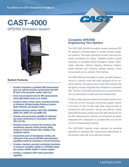
<strong>CAST</strong>-<strong>4000</strong><br />
<strong>GPS</strong>/<strong>INS</strong> <strong>Simulation</strong> <strong>System</strong><br />
Complete <strong>GPS</strong>/<strong>INS</strong><br />
Engineering Test <strong>System</strong><br />
The <strong>CAST</strong>-<strong>4000</strong> <strong>GPS</strong>/<strong>INS</strong> simulation system produces <strong>GPS</strong><br />
RF signals to stimulate tightly or loosely-coupled navigation<br />
systems. The system algorithms contain mature avionic<br />
sensor simulations for aiding. Available sensors include<br />
strapdown or gimbaled Inertial <strong>Navigation</strong> <strong>System</strong>, Barometric<br />
Altimeter, Attitude Heading Reference <strong>System</strong>,<br />
Radar Altimeter and numerous auxiliary sensors, which<br />
are accessed over an optional 1553 interface.<br />
<strong>System</strong> Features<br />
• Provides strapdown or gimbaled IMU measurement<br />
data over optional interface synchronized with <strong>GPS</strong><br />
RF data to the navigation system under test.<br />
• Errors may be injected into the IMU measurements<br />
using high fidelity sensor error models.<br />
• Contains mature avionic sensor simulation Barometric<br />
Altimeter, Attitude Heading Reference <strong>System</strong>,<br />
Radar Altimeter, and Doppler model.<br />
• Optional interfaces include 1553/1394, SCRAMNet,<br />
ARINC 575, ARINC 572 and ARINC 429.<br />
• Includes post-processing capability for determining<br />
system performance in accordance with ICD-<br />
<strong>GPS</strong>-215/150.<br />
• Simulates sensors to provide the necessary fully<br />
coordinated, dynamic vertical channel aiding<br />
needed to maintain Kalman filter stability of the<br />
navigation system.<br />
• Incorporates years of development, testing, and<br />
refinement of the precise <strong>GPS</strong>/<strong>INS</strong> synchronization<br />
capability needed for simulation of aircraft dynamics.<br />
• Provides a dynamic, precisely coordinated simulation<br />
of numerous navigation signals to a <strong>GPS</strong>/<strong>INS</strong> navigation<br />
system, whether tightly or loosely coupled.<br />
• Includes a complete 6-DOF motion generation<br />
capability.<br />
The <strong>CAST</strong>-<strong>4000</strong> has the ability to output raw IMU measurements<br />
to a receiver under test when equipped with an optional<br />
interface. This allows users to test <strong>GPS</strong> receivers that<br />
are tightly or loosely integrated with a strapdown or gimbaled<br />
IMU. The form of the optional interface (bus, shared memory,<br />
etc.) is customized to a user’s particular requirements.<br />
An IMU contains accelerometers that measure specific force<br />
in the form of ∆V’s and gyros that provide angular velocity<br />
in the form of ∆θ’s. An <strong>INS</strong> uses these measurements to<br />
compute the user’s position, velocity, and attitude. Inertial<br />
aided <strong>GPS</strong> receivers usually receive the <strong>INS</strong> outputs and not<br />
the IMU measurements. However, some receivers are tightly<br />
integrated with a strapdown or gimbaled IMU and use the<br />
∆V and ∆θ measurements directly.<br />
The <strong>CAST</strong>-<strong>4000</strong> supports aided receivers by providing<br />
strapdown or gimbaled IMU measurement data directly to<br />
the receiver under test via an optional interface.<br />
castnav.com
<strong>CAST</strong>-<strong>4000</strong><br />
<strong>GPS</strong>/<strong>INS</strong> <strong>Simulation</strong> <strong>System</strong><br />
<strong>System</strong> Specifications<br />
Output Frequency<br />
• <strong>GPS</strong> L1<br />
• <strong>GPS</strong> L2<br />
• <strong>GPS</strong> L5<br />
1575.42 MHz<br />
1227.60 MHz<br />
1176.45 MHz<br />
Maximum Dynamics<br />
• Velocity<br />
> 60,000 m/s<br />
• Acceleration ± 150,000 m/s 2<br />
• Jerk ± 150,000 m/s 3<br />
Signal Level<br />
• <strong>GPS</strong> L1 C/A Code<br />
• <strong>GPS</strong> L1 P Code<br />
• <strong>GPS</strong> L2 P Code<br />
Signal Level Control<br />
• Range<br />
• Resolution<br />
L1/L2 Differential Delay<br />
• Range<br />
• Resolution<br />
Signal Accuracy<br />
• Pseudorange<br />
• Pseudorange Rate<br />
• Delta Pseudorange<br />
• Interchannel Bias<br />
• Uncontrolled Bias<br />
• Bias Repeatability (initial)<br />
• Bias Stability (operational)<br />
Signal Quality<br />
• Spurious<br />
• Harmonics<br />
• Reference Oscillator<br />
• Frequency Stability<br />
-160 dBW<br />
-163 dBW<br />
-166 dBW<br />
± 30 dB<br />
0.1 dB<br />
± 0.3 m<br />
< 1 mm<br />
1 mm<br />
1 mm/s<br />
1 mm<br />
< 1 mm<br />
< 1 mm<br />
< 1 mm<br />
< 1 mm<br />
< -45 dBc<br />
< -50 dBc<br />
100 MHz OCXO<br />
3x10 -8 per day<br />
<strong>System</strong> Configuration<br />
• <strong>GPS</strong> Satellites Generated 12 to 16<br />
L1, L2, L5<br />
• Size (H x W x D) 55” x 24” x 32”<br />
• Weight (approximate)<br />
300 lbs<br />
• Power Required<br />
110/220 VAC<br />
50/60 Hz, 1500 W<br />
• Operating <strong>System</strong> Windows, Lynx<br />
<strong>System</strong> Options<br />
• Multiple <strong>GPS</strong>/<strong>INS</strong> Configuration Testing<br />
• Up to 8 Interference Generators<br />
• Precision Guided Munitions Testing<br />
• 1553 / 1394<br />
• ARINC 575, 572 and 429<br />
• External Precision Oscillator<br />
• 6-DOF Real-Time Interface<br />
• Y-Code<br />
• SAASM<br />
• OFP Loading – for <strong>GPS</strong> and <strong>INS</strong><br />
• Terrain Obscuration (TOP)<br />
• TOP with Enhanced 3-D Visualization<br />
• JDAM IMU Interface<br />
• M-Code<br />
• SBAS <strong>Simulation</strong><br />
• L2C<br />
• L5<br />
<strong>System</strong> Upgrade Path<br />
• <strong>CAST</strong>-3000 for EGI Integration<br />
• <strong>CAST</strong> EMT3500-3 for EGI Diagnostics<br />
• <strong>CAST</strong>-5000 for CRPA <strong>System</strong> Testing<br />
The <strong>CAST</strong>-<strong>4000</strong> Strapdown IMU Interface<br />
<strong>CAST</strong> <strong>Navigation</strong>, LLC<br />
One Highwood Drive, Suite 100<br />
Tewksbury, MA 01876<br />
Tel: 978 858-0130<br />
Fax: 978 858-0170<br />
Email: sales@castnav.com<br />
Copyright © 2012 <strong>CAST</strong> <strong>Navigation</strong>, LLC. All Rights Reserved.<br />
Specifications subject to change without notice.<br />
castnav.com