

Terrerstrial 3D Laser Scanning Surveying Brochure - DJ and A PC
Terrerstrial 3D Laser Scanning Surveying Brochure - DJ and A PC
Terrerstrial 3D Laser Scanning Surveying Brochure - DJ and A PC

You also want an ePaper? Increase the reach of your titles
YUMPU automatically turns print PDFs into web optimized ePapers that Google loves.
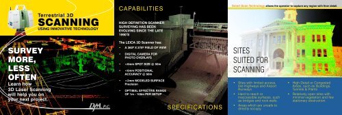
Terrestrial <strong>3D</strong><br />
SCANNING<br />
USING INNOVATIVE TECHNOLOGY<br />
CAPABILITIES<br />
HIGH DEFINITION SCANNER<br />
SURVEYING HAS BEEN<br />
EVOLVING SINCE THE LATE<br />
1990’S<br />
Smart Scan Technology allows the operator to capture any region with finer detail.<br />
SURVEY<br />
MORE,<br />
LESS<br />
OFTEN<br />
Learn how<br />
<strong>3D</strong> <strong>Laser</strong> <strong>Scanning</strong><br />
will help you on<br />
your next project.<br />
The LEICA <strong>3D</strong> Scanner has:<br />
• A 360º X 270º FIELD OF VIEW<br />
• DIGITAL CAMERA FOR<br />
PHOTO OVERLAYS<br />
•
Actual “Point Cloud Data”<br />
represented in each image<br />
of this brochure.<br />
where to use the<br />
<strong>Laser</strong> Scanner<br />
Get measurements from<br />
any data point<br />
ALWAYS<br />
CONSIDER<br />
Benefits:<br />
the<br />
<strong>DJ</strong>&A, P.C. Engineers. Planners. Surveyors.<br />
3203 Russell Street / Missoula, MT 59801<br />
P: (406)721-4320 F: (406)549-6371<br />
info@dj<strong>and</strong>a.com<br />
www.dj<strong>and</strong>a.com<br />
• Highways & Roadways<br />
• Bridges<br />
• Retainging Walls<br />
• Dams<br />
• Geotechnical Analysis<br />
• Emergency Repairs<br />
L<strong>and</strong> Slides, Slumps, Washouts &<br />
Structure Collapse<br />
• Volume, Quantity, Grade, Unstable<br />
Slope Surveys<br />
• Tunnel & Cave Surveys<br />
• Utility Surveys<br />
Towers, Poles, Overhead Lines &<br />
Substations<br />
• Cultural & Archaeological Surveys<br />
• Industrical Plants<br />
• Oil & Gas Refinery <strong>and</strong> Bulk Plants<br />
• Buildings<br />
Inside & Out<br />
• Forensics<br />
Crime & Accident Scenes<br />
Images: Full Field View 2) Structure Detail<br />
><br />
><br />
><br />
><br />
26.943 ft<br />
Immediate<br />
Measurements<br />
26.943 ft<br />
Increased confidence in the<br />
mapping data<br />
Potential for extracting<br />
additional data from the<br />
existing dataset at a later<br />
time<br />
A fast turnaround on data or<br />
mapping<br />
Time & cost savings on<br />
active or highly detailed<br />
project sites<br />
Minimal return trips to<br />
remote sites<br />
A record of as-constructed<br />
or existing site conditions to<br />
retrofit