Unclassified Unclassified - GPS.gov
Unclassified Unclassified - GPS.gov
Unclassified Unclassified - GPS.gov

Create successful ePaper yourself
Turn your PDF publications into a flip-book with our unique Google optimized e-Paper software.
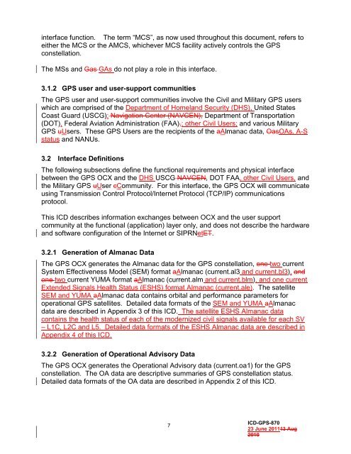
interface function. The term “MCS”, as now used throughout this document, refers to<br />
either the MCS or the AMCS, whichever MCS facility actively controls the <strong>GPS</strong><br />
constellation.<br />
The MSs and Gas GAs do not play a role in this interface.<br />
3.1.2 <strong>GPS</strong> user and user-support communities<br />
The <strong>GPS</strong> user and user-support communities involve the Civil and Military <strong>GPS</strong> users<br />
which are comprised of the Department of Homeland Security (DHS), United States<br />
Coast Guard (USCG); Navigation Center (NAVCEN), Department of Transportation<br />
(DOT), Federal Aviation Administration (FAA),; other Civil Users; and various Military<br />
<strong>GPS</strong> uUsers. These <strong>GPS</strong> Users are the recipients of the aAlmanac data, OasOAs, A-S<br />
status and NANUs.<br />
3.2 Interface Definitions<br />
The following subsections define the functional requirements and physical interface<br />
between the <strong>GPS</strong> OCX and the DHS USCG NAVCEN, DOT FAA, other Civil Users, and<br />
the Military <strong>GPS</strong> uUser cCommunity. For this interface, the <strong>GPS</strong> OCX will communicate<br />
using Transmission Control Protocol/Internet Protocol (TCP/IP) communications<br />
protocol.<br />
This ICD describes information exchanges between OCX and the user support<br />
community at the functional (application) layer only, and does not describe the hardware<br />
and software configuration of the Internet or SIPRNetET.<br />
3.2.1 Generation of Almanac Data<br />
The <strong>GPS</strong> OCX generates the Almanac data for the <strong>GPS</strong> constellation, one two current<br />
System Effectiveness Model (SEM) format aAlmanac (current.al3 and current.bl3), and<br />
one two current YUMA format aAlmanac (current.alm and current.blm), and one current<br />
Extended Signals Health Status (ESHS) format Almanac (current.ale). The satellite<br />
SEM and YUMA aAlmanac data contains orbital and performance parameters for<br />
operational <strong>GPS</strong> satellites. Detailed data formats of the SEM and YUMA aAlmanac<br />
data are described in Appendix 3 of this ICD. The satellite ESHS Almanac data<br />
contains the health status of each of the modernized civil signals available for each SV<br />
– L1C, L2C and L5. Detailed data formats of the ESHS Almanac data are described in<br />
Appendix 4 of this ICD.<br />
3.2.2 Generation of Operational Advisory Data<br />
The <strong>GPS</strong> OCX generates the Operational Advisory data (current.oa1) for the <strong>GPS</strong><br />
constellation. The OA data are descriptive summaries of <strong>GPS</strong> constellation status.<br />
Detailed data formats of the OA data are described in Appendix 2 of this ICD.<br />
7<br />
ICD-<strong>GPS</strong>-870<br />
23 June 201113 Aug<br />
2010