Technical Report on Resources Cerro Colorado ... - Goldgroup Mining
Technical Report on Resources Cerro Colorado ... - Goldgroup Mining
Technical Report on Resources Cerro Colorado ... - Goldgroup Mining

Create successful ePaper yourself
Turn your PDF publications into a flip-book with our unique Google optimized e-Paper software.
<str<strong>on</strong>g>Technical</str<strong>on</strong>g> <str<strong>on</strong>g>Report</str<strong>on</strong>g> <strong>on</strong> <strong>Resources</strong><br />
<strong>Cerro</strong> <strong>Colorado</strong> Gold Mine<br />
S<strong>on</strong>ora, Mexico<br />
<strong>Goldgroup</strong> <strong>Mining</strong> Inc.<br />
1055 Dunsmuir Street<br />
Suite 2184<br />
Vancouver BC Canada<br />
V7X 1L3<br />
Date: May 14, 2012<br />
Effective date: February 29, 2012<br />
Prepared by:<br />
Marc Simps<strong>on</strong> P.Geo.<br />
2184-1055 Dunsmuir Street,<br />
Vancouver BC<br />
And<br />
Gary Giroux, MASc., P.Eng.<br />
Giroux C<strong>on</strong>sultants Ltd.<br />
1215 – 675 West Hastings Street<br />
Vancouver, B.C. CANADA<br />
And<br />
Fernando Rodrigues BSc, MBA, MAusIMM, MMSAQP<br />
SRK C<strong>on</strong>sulting (U.S.) Ltd.<br />
Suite 3000<br />
7175 West Jeffers<strong>on</strong> Avenue<br />
Lakewood, <strong>Colorado</strong>, USA
Table of C<strong>on</strong>tents<br />
1. Summary ......................................................................................................... 6<br />
2. Introducti<strong>on</strong> ..................................................................................................... 8<br />
i) Scope of Work and Terms of Reference ......................................................... 8<br />
ii) Terminology and Unit C<strong>on</strong>versi<strong>on</strong> .................................................................. 8<br />
3. Reliance <strong>on</strong> Other Experts ............................................................................. 10<br />
4. Property Descripti<strong>on</strong> and Locati<strong>on</strong> ................................................................ 11<br />
5. Accessibility, Climate, Local <strong>Resources</strong>, Infrastructure and Physiography . 16<br />
i) Access ............................................................................................................ 16<br />
ii) Climate .......................................................................................................... 16<br />
iii) Local <strong>Resources</strong> and Infrastructure ............................................................... 16<br />
iv) Physiography ................................................................................................. 18<br />
6. History ........................................................................................................... 19<br />
i) Explorati<strong>on</strong> History ....................................................................................... 19<br />
a. C<strong>on</strong>tratista Tormex ........................................................................................ 19<br />
b. Papant<strong>on</strong> Minas S.A. de C.V. – BP Minerals ................................................ 19<br />
c. Compañía Fresnillo S.A. ............................................................................... 19<br />
d. Minera Secotec S.A. de C.V. ......................................................................... 20<br />
e. Sierra Minerals .............................................................................................. 23<br />
f. <strong>Goldgroup</strong> <strong>Mining</strong> Inc. .................................................................................. 24<br />
7. Geological Setting and Mineralizati<strong>on</strong> .......................................................... 25<br />
i) Regi<strong>on</strong>al Geology .......................................................................................... 25<br />
ii) Local and Property Geology .......................................................................... 26<br />
iii) Structural Geology ........................................................................................ 30<br />
iv) Mineralizati<strong>on</strong> ............................................................................................... 32<br />
a. Breccia Central .............................................................................................. 32<br />
b. Obra X ........................................................................................................... 32<br />
c. Harris - Sorpresa - Abejas Areas ................................................................... 33<br />
d. Abejas ............................................................................................................ 34<br />
e. Harris Breccia ................................................................................................ 34<br />
f. La Sorpresa .................................................................................................... 37<br />
8. Deposit Types ................................................................................................ 39<br />
9. Explorati<strong>on</strong> .................................................................................................... 40<br />
10. Drilling .......................................................................................................... 41<br />
11. Sample Preparati<strong>on</strong>, Analyses and Security .................................................. 46<br />
i) Sample Preparati<strong>on</strong> Procedure at the On Site Laboratory ............................. 46<br />
12. Data Verificati<strong>on</strong> ........................................................................................... 48<br />
i) Site Visit, November 2011 ............................................................................ 48<br />
13. Mineral Processing and Metallurgical Testing .............................................. 49<br />
i) Historic .......................................................................................................... 49<br />
ii) Present Processing and Metallurgical Testing ............................................... 49<br />
a. Processing and Metallurgical Informati<strong>on</strong> .................................................... 49<br />
b. Ore Processing ............................................................................................... 50<br />
c. Plant Performance ......................................................................................... 50<br />
1 | P age
d. Plant flow sheet descripti<strong>on</strong> .......................................................................... 51<br />
e. Heap Pads (pad design) ................................................................................. 53<br />
f. M<strong>on</strong>itoring daily c<strong>on</strong>trol ............................................................................... 55<br />
g. Gold Analysis ................................................................................................ 55<br />
14. MINERAL RESOURCE ESTIMATION ..................................................... 57<br />
i) Data Analysis ................................................................................................ 57<br />
ii) Composites .................................................................................................... 61<br />
iii) Variography ................................................................................................... 62<br />
iv) Block Model .................................................................................................. 62<br />
v) Bulk Density .................................................................................................. 63<br />
vi) Grade Interpolati<strong>on</strong> ........................................................................................ 64<br />
vii) Classificati<strong>on</strong> ................................................................................................. 65<br />
viii) Block Model Verificati<strong>on</strong> .............................................................................. 68<br />
ix) Pit Optimizati<strong>on</strong> Study .................................................................................. 75<br />
a. Mineral Resource Statement Procedure ........................................................ 75<br />
x) Block Model Resource Within the Resource Whittle Shell .......................... 89<br />
15. Mineral Reserve Estimates ............................................................................ 90<br />
16. <strong>Mining</strong> Methods ............................................................................................ 91<br />
17. Recovery Methods ......................................................................................... 97<br />
i) Forecast Producti<strong>on</strong> ....................................................................................... 98<br />
ii) Gold Recovery ............................................................................................... 99<br />
18. Project Infrastructure ................................................................................... 100<br />
19. Market Studies and C<strong>on</strong>tracts ...................................................................... 101<br />
20. Envir<strong>on</strong>mental Studies, Permitting and Social or Community Impact ....... 102<br />
21. Capital and Operating Costs ........................................................................ 103<br />
22. Ec<strong>on</strong>omic Analysis ...................................................................................... 104<br />
23. Adjacent Properties ..................................................................................... 105<br />
24. Other Relevant Data and Informati<strong>on</strong> ......................................................... 106<br />
25. Interpretati<strong>on</strong> and C<strong>on</strong>clusi<strong>on</strong>s .................................................................... 107<br />
26. Recommendati<strong>on</strong>s ....................................................................................... 109<br />
27. Date and Signature Page .............................................................................. 111<br />
28. References ................................................................................................... 113<br />
29. Appendix 1 - Certificates ............................................................................ 114<br />
30. Appendix 2 – LISTING OF DRILL HOLES .............................................. 118<br />
Those that intersect the mineralized solids are highlighted ............................................ 118<br />
31. Appendix 3– SEMIVARIOGRAMS ........................................................... 139<br />
2 | P age
Table of Tables<br />
Table 1: <strong>Cerro</strong> <strong>Colorado</strong> C<strong>on</strong>cessi<strong>on</strong>s, April 2012 ........................................................... 14<br />
Table 2: Significant 2010 drill program results ................................................................ 41<br />
Table 3: Significant 2010-2011 drill program results ....................................................... 41<br />
Table 4: Gold assay statistics for samples within the mineralized solids ......................... 60<br />
Table 5: Gold populati<strong>on</strong>s present within mineralized solids ........................................... 60<br />
Table 6: Capped Gold assay statistics for samples within the mineralized solids ............ 60<br />
Table 7: Gold statistics for 5 m Composites inside and outside the mineralized solids ... 61<br />
Table 8: Semivariogram parameters for gold ................................................................... 62<br />
Table 9: Specific gravities used in the 2009 resource model (St<strong>on</strong>e, 2011) ..................... 64<br />
Table 10: Kriging search parameters for gold .................................................................. 65<br />
Table 11: Measured Resource in Mineralized Porti<strong>on</strong> of Blocks ..................................... 67<br />
Table 12: Indicated Resource in Mineralized Porti<strong>on</strong> of Blocks ...................................... 67<br />
Table 13: Measured plus Indicated Resource in Mineralized Porti<strong>on</strong> of Blocks ............. 67<br />
Table 14: Inferred Resource in Mineralized Porti<strong>on</strong> of Blocks ........................................ 67<br />
Table 15: Measured Resource in Total Blocks ................................................................. 68<br />
Table 16: Indicated Resource in Total Blocks .................................................................. 68<br />
Table 17: Measured plus Indicated Resource in Total Blocks ......................................... 68<br />
Table 18: Inferred Resource in Total Blocks .................................................................... 68<br />
Table 19: Measured Resource in Mineralized Porti<strong>on</strong> of Blocks within SRK Pit ............ 89<br />
Table 20: Indicated Resource in Mineralized Porti<strong>on</strong> of Blocks within SRK Pit Outline 89<br />
Table 21: Measured and Indicated Resource in Mineralized Porti<strong>on</strong> of Blocks within<br />
SRK Pit Outline ................................................................................................................ 89<br />
Table 22: Inferred Resource in Mineralized Porti<strong>on</strong> of Blocks within SRK Pit Outline . 89<br />
Table 23: Gold Recovery 2011 (source: <strong>Goldgroup</strong> AIF) ................................................ 99<br />
Table 24: 2010 and 2011 Operating costs per ounce of gold ......................................... 103<br />
Table 25: Proposed Budget, <strong>Cerro</strong> <strong>Colorado</strong> .................................................................. 110<br />
3 | P age
Table of Figures<br />
Figure 1: <strong>Cerro</strong> <strong>Colorado</strong> Mine Site C<strong>on</strong>cessi<strong>on</strong>s ............................................................ 12<br />
Figure 2: Overall <strong>Cerro</strong> <strong>Colorado</strong> C<strong>on</strong>cessi<strong>on</strong>s, March 2012........................................... 13<br />
Figure 3: Ownership Structure .......................................................................................... 15<br />
Figure 4: <strong>Cerro</strong> <strong>Colorado</strong> Infrastructure, November 2011 ............................................... 17<br />
Figure 5: General Physiography of <strong>Cerro</strong> <strong>Colorado</strong>, November 2011 ............................. 18<br />
Figure 6: Map showing the explorati<strong>on</strong> targets defined by Secotec based <strong>on</strong> the results of<br />
soil sampling (modified from Kappes, Cassiday & Associates (2005)). .......................... 23<br />
Figure 7: Regi<strong>on</strong>al Geological Map, <strong>Cerro</strong> <strong>Colorado</strong> ....................................................... 28<br />
Figure 8: Local geological map of the area around the <strong>Cerro</strong> <strong>Colorado</strong> Gold Mine ........ 29<br />
Figure 9: Mineralizati<strong>on</strong> model for <strong>Cerro</strong> <strong>Colorado</strong> from St<strong>on</strong>e (2011) .......................... 35<br />
Figure 10: L<strong>on</strong>g secti<strong>on</strong> through the Breccia Central area looking north. from St<strong>on</strong>e<br />
(2011) ................................................................................................................................ 36<br />
Figure 11: Drill Hole Locati<strong>on</strong> Map, <strong>Cerro</strong> <strong>Colorado</strong> ...................................................... 45<br />
Figure 12: Process diagram for gold producti<strong>on</strong> at <strong>Cerro</strong> <strong>Colorado</strong>. From St<strong>on</strong>e (2011) 53<br />
Figure 13: Isometric view looking north showing Feb. Topography and mineralized<br />
solids ................................................................................................................................. 57<br />
Figure 14: Plan and fr<strong>on</strong>t secti<strong>on</strong> showing blast holes in blue and drill hole assays in red<br />
........................................................................................................................................... 58<br />
Figure 15: Lognormal Cumulative Frequency Plot for All Samples ................................ 59<br />
Figure 16: Lognormal Cumulative Frequency Plot for All Samples within Mineralized<br />
Solids................................................................................................................................. 59<br />
Figure 17: Lognormal Cumulative Frequency Plot for Au within Mineralized Solids .... 61<br />
Figure 18: Isometric view looking NE showing blocks below current topography in white<br />
and mineralized solids in red ............................................................................................ 63<br />
Figure 19: Plan view showing various sample areas (St<strong>on</strong>e, 2011) ................................. 64<br />
Figure 20: Level plan showing 560 level with gold grades and classificati<strong>on</strong> shown ...... 70<br />
Figure 21: Level plan showing 570 Level with gold grades and classificati<strong>on</strong> shown .... 71<br />
Figure 22:Level plan showing 580 Level with gold grades and classificati<strong>on</strong> shown ..... 72<br />
Figure 23: Level plan showing 590 Level with gold grades and classificati<strong>on</strong> shown .... 73<br />
Figure 24: : Level plan showing 600 Level with gold grades and classificati<strong>on</strong> shown .. 74<br />
Figure 25: Resource Whittle shell at Gold price $1500 per t.oz – Plan view .................. 76<br />
Figure 26: Resource Whittle shell at Gold price $1500 per t.oz – Plan view showing<br />
current topography and shell ............................................................................................. 78<br />
Figure 27: Resource Whittle shell at Gold price $1500 per t.oz – Vertical Cross Secti<strong>on</strong><br />
View showing current topography and shell (West-East at 3,343,900 North, looking<br />
North ................................................................................................................................. 80<br />
Figure 28: Resource Whittle shell at Gold price $1500 per t.oz – Vertical Cross Secti<strong>on</strong><br />
View showing current topography and shell (West-East @ 3,344,100 North, looking<br />
North ) ............................................................................................................................... 82<br />
Figure 29: Resource Whittle shell at Gold price $1500 per t.oz – Vertical Cross Secti<strong>on</strong><br />
View showing current topography and shell (West-East secti<strong>on</strong> @ 3,344,200 North,<br />
looking North ) .................................................................................................................. 84<br />
Figure 30: Resource Whittle shell at Gold price $1500 per t.oz – Vertical Cross Secti<strong>on</strong><br />
View showing current topography and shell (West-East at 3,344,300 North ) ................ 86<br />
4 | P age
Figure 31: Resource Whittle shell at Gold price $1500 per t.oz – Vertical Cross Secti<strong>on</strong><br />
View showing current topography and a shell (SW – NE Secti<strong>on</strong> @ N45E, looking northwest<br />
) ................................................................................................................................. 88<br />
Figure 32: Blast hole drill ................................................................................................. 92<br />
Figure 33: Bench blast hole pattern November 2011 ....................................................... 92<br />
Figure 34: Ore haulage, Breccia Central Pit, November 2011 ......................................... 93<br />
Figure 35: loading ore into primary crusher, photo courtesy <strong>Goldgroup</strong> ......................... 93<br />
Figure 36: primary and sec<strong>on</strong>dary crushers, photo courtesy <strong>Goldgroup</strong> .......................... 94<br />
Figure 37: crushed mineralized material stockpile for placement <strong>on</strong> heap leach pad, photo<br />
courtesy <strong>Goldgroup</strong> ........................................................................................................... 94<br />
Figure 38: <strong>Cerro</strong> <strong>Colorado</strong> Heap Leach Pads, November 2011 ....................................... 95<br />
Figure 39: Heap leach pad lift/level with cyanide distributi<strong>on</strong> piping and sprinklers,<br />
November 2011 ................................................................................................................. 96<br />
Figure 40: Sprinklers for broadcasting cyanide soluti<strong>on</strong> <strong>on</strong> heap leach pad, November<br />
2011................................................................................................................................... 96<br />
Figure 41: Carb<strong>on</strong> flow circuit, <strong>Cerro</strong> <strong>Colorado</strong> November 2011 .................................... 98<br />
5 | P age
1. Summary<br />
This technical report was prepared for <strong>Goldgroup</strong> <strong>Mining</strong> Inc. (“<strong>Goldgroup</strong>”) to document an<br />
updated mineral resource estimate and complete a technical report (the “<str<strong>on</strong>g>Report</str<strong>on</strong>g>”) compliant with<br />
Nati<strong>on</strong>al Instrument 43-101 (“NI 43-101”), compani<strong>on</strong> policy NI 43-101CP and Form 43-101F1<br />
for the <strong>Cerro</strong> <strong>Colorado</strong> Property and mine in S<strong>on</strong>ora, Mexico. This <str<strong>on</strong>g>Report</str<strong>on</strong>g> provides a brief<br />
overview of the work programs completed by <strong>Goldgroup</strong> during 2010 and 2011 and the results<br />
of the resource estimate and pit optimizati<strong>on</strong> study.<br />
The <strong>Cerro</strong> <strong>Colorado</strong> Gold Mine is located in northern S<strong>on</strong>ora, Mexico approximately 35<br />
kilometres southwest of the town of Trincheras. The Property c<strong>on</strong>sists of six c<strong>on</strong>cessi<strong>on</strong>s<br />
covering the area of the mine and 48 c<strong>on</strong>cessi<strong>on</strong>s in the immediate vicinity of the mine covering<br />
a total of approximately 24,100 hectares. <strong>Cerro</strong> <strong>Colorado</strong> is owned by <strong>Goldgroup</strong> through its<br />
Mexican operating company Granmin S.A. de C.V. (“Granmin Mexico”). Cyanide leaching at<br />
<strong>Cerro</strong> <strong>Colorado</strong> commenced in 2003 and has produced approximately 128,611 ounces of gold<br />
between the 3 rd quarter of 2006 and the 1 st quarter of 2012.<br />
Property geology is composed of three major units, Proterozoic amphibolite to orthogneiss,<br />
Paleozoic layered dolomite/limest<strong>on</strong>e (marble) with minor siltst<strong>on</strong>e/arenite. Both of these<br />
lithologies are intruded by a central mid Cretaceous age rhyolite dome. The rhyolite is generally<br />
massive although locally it is flow banded or occurs as rhyolite auto-breccia. Gold mineralizati<strong>on</strong><br />
is mostly hosted by the rhyolite although some gold is found locally within dolomite layers <strong>on</strong><br />
the west side of the dome.<br />
<strong>Goldgroup</strong>’s explorati<strong>on</strong> model for <strong>Cerro</strong> <strong>Colorado</strong> is the Kidst<strong>on</strong> gold-silver deposit,<br />
Queensland, Australia (e.g., Baker and Andrew, 1991). The Kidst<strong>on</strong> was a significant gold<br />
deposit and c<strong>on</strong>tained high grade resources. Mineralizati<strong>on</strong> was hosted within a trapezoid-shaped<br />
breccia pipe with surface dimensi<strong>on</strong>s of approximately 900 metres by 1,100 metres 900 metres.<br />
Rhyolite dikes are associated both spatially and temporally with the mineralizati<strong>on</strong> and<br />
brecciati<strong>on</strong> of the host rocks. Furthermore, the collapse breccia does not reach the current land<br />
surface. At the Kidst<strong>on</strong> deposit, mineralizati<strong>on</strong> that was not related to the breccia (stockwork in<br />
host rhyolite) was unec<strong>on</strong>omic. The breccias at Kidst<strong>on</strong> formed a single mineralized system<br />
which coalesced at depth.<br />
The open pits have been operati<strong>on</strong>al since 2003, with full producti<strong>on</strong> starting in 2006. In 2011,<br />
the full year producti<strong>on</strong> totalled 20,361.112 ounces, with an additi<strong>on</strong>al 4,462 ounces produced in<br />
the first quarter of 2012. Two pits are currently operating; Breccia Central and Obra X. A total of<br />
85,058 metres in 821 explorati<strong>on</strong> holes have been drilled in and around the mine to the end of<br />
2011.<br />
The results of the 2010-2011 explorati<strong>on</strong> drilling were used to estimate the total t<strong>on</strong>nes and grade<br />
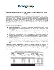
of mineralizati<strong>on</strong> at the <strong>Cerro</strong> <strong>Colorado</strong> Gold Mine. The mineral resource for the <strong>Cerro</strong> <strong>Colorado</strong><br />
Gold Mine area at a 0.2 g/t Au cut-off is estimated to be approximately 720,000 t<strong>on</strong>nes at 0.62<br />
g/t Au in the Measured category, 1.86 milli<strong>on</strong> t<strong>on</strong>nes at 0.51 g/t Au in the Indicated category and<br />
3.05 milli<strong>on</strong> t<strong>on</strong>nes at 0.57 g/t Au in the Inferred category. These mineral resources c<strong>on</strong>tain a<br />
6 | P age
total of 14,000 Measured ounces, 30,000 Indicated ounces and 56,000 Inferred ounces of gold.<br />
Mineral resources were calculated from explorati<strong>on</strong> drilling data in the area of the mine. Mineral<br />
resources are not mineral reserves as the ec<strong>on</strong>omic viability has not been dem<strong>on</strong>strated.<br />
SRK completed a pit optimizati<strong>on</strong> study for the <strong>Cerro</strong> <strong>Colorado</strong> Mine and created a Whittle Shell<br />
for Measured and Indicated Resource, using parameters supplied by <strong>Goldgroup</strong>. Using this<br />
Whittle Shell model, a total of 33,000 ounces of Measured and Indicated resource and 1,300<br />
ounces of Inferred resource are c<strong>on</strong>tained within the modeled Whittle Shells.<br />
Work recommended at the <strong>Cerro</strong> <strong>Colorado</strong> Mine should c<strong>on</strong>tinue to focus <strong>on</strong> outlining additi<strong>on</strong>al<br />
mineralizati<strong>on</strong> to extend the life of the mine as well as define and upgrade existing resources for<br />
the mine. A full QAQC program for all explorati<strong>on</strong> drilling completed at <strong>Cerro</strong> <strong>Colorado</strong> is<br />
recommended al<strong>on</strong>g with downhole surveys of future drilling programs. A 10,000 metre<br />
explorati<strong>on</strong> drill program is recommended to outline additi<strong>on</strong>al mineralizati<strong>on</strong> in the <strong>Cerro</strong><br />
<strong>Colorado</strong> Mine area.<br />
7 | P age
2. Introducti<strong>on</strong><br />
This technical report presents an independent review and updated estimati<strong>on</strong> of a precious<br />
metal resource at the <strong>Cerro</strong> <strong>Colorado</strong> Mine in S<strong>on</strong>ora State, Mexico. The report has been<br />
prepared by Marc Simps<strong>on</strong>, P. Geo. (Qualified Pers<strong>on</strong>), Gary Giroux, P. Eng. (Qualified<br />
Pers<strong>on</strong>) of Giroux C<strong>on</strong>sultants Ltd., and Fernando Rodrigues BSc, MBA, MAusIMM,<br />
MMSAQP (Qualified Pers<strong>on</strong>) of SRK C<strong>on</strong>sulting at the request of Mr. Keith Piggott,<br />
President and CEO of <strong>Goldgroup</strong> <strong>Mining</strong> Inc. <strong>Goldgroup</strong> is a public company with head<br />
offices in Vancouver, B.C. Canada and a main field office in Hermosillo, Mexico.<br />
Summaries and c<strong>on</strong>clusi<strong>on</strong>s c<strong>on</strong>tained in this report are c<strong>on</strong>sidered compliant with Nati<strong>on</strong>al<br />
Instrument 43-101 and the December 11, 2005 Canadian Institute of <strong>Mining</strong>, Metallurgy<br />
and Petroleum (CIM) standards and definiti<strong>on</strong>s. This report may be used by the company to<br />
support and maintain future public financings.<br />
i) Scope of Work and Terms of Reference<br />
One field visit to the <strong>Cerro</strong> <strong>Colorado</strong> Mine was completed by Marc Simps<strong>on</strong> <strong>on</strong> November 29 th ,<br />
2011. He was accompanied by Vice President of Explorati<strong>on</strong> Kevin Sullivan and Senior<br />
Geologist Omar Felix, both with <strong>Goldgroup</strong>. During the field visit Simps<strong>on</strong> was able to verify<br />
drill hole collar locati<strong>on</strong>s, visit the <strong>on</strong>-site laboratory, sample storage facilities, explorati<strong>on</strong>/mine<br />
offices and the processing plant. However no explorati<strong>on</strong> drilling activity was being carried out<br />
during the site visit. The author has relied <strong>on</strong> informati<strong>on</strong> from <strong>Goldgroup</strong> regarding the<br />
procedures used for the explorati<strong>on</strong> drilling programs at the <strong>Cerro</strong> <strong>Colorado</strong> mine.<br />
Data compilati<strong>on</strong> for this technical report <strong>on</strong> <strong>Cerro</strong> <strong>Colorado</strong> is based <strong>on</strong> research from<br />
internal reports, opini<strong>on</strong>s and general impressi<strong>on</strong>s and ideas gathered from <strong>Goldgroup</strong><br />
pers<strong>on</strong>nel. Electr<strong>on</strong>ic data were obtained from company ‘MapInfo’ and 'Surpac' databases<br />
c<strong>on</strong>taining the bulk of the geological, geophysical and geochemical informati<strong>on</strong> generated<br />
<strong>on</strong> the project. All regi<strong>on</strong>al and local property maps, figures and diagrams in this report were<br />
generated by <strong>Goldgroup</strong> or the authors using a UTM NAD27 US (Z<strong>on</strong>e 14N) projecti<strong>on</strong> or<br />
NAD27 L<strong>on</strong>gitude / Latitude (Mexico) where the scale dictates. Current field work <strong>on</strong> the<br />
property is all being collected in UTM WGS84 (Z<strong>on</strong>e 14N). The authors have drawn their<br />
own c<strong>on</strong>clusi<strong>on</strong>s for this report and have prepared it based <strong>on</strong> informati<strong>on</strong> believed accurate<br />
at the time of completi<strong>on</strong>.<br />
ii)<br />
Terminology and Unit C<strong>on</strong>versi<strong>on</strong><br />
The Metric System is the primary system of measure used in this <str<strong>on</strong>g>Report</str<strong>on</strong>g>. Length is generally<br />
expressed in kilometres, metres and centimetres, volume is expressed as cubic metres, mass<br />
expressed as metric t<strong>on</strong>nes, and gold grades are expressed as “grams per t<strong>on</strong>ne” and abbreviated<br />
as g/t Au.<br />
8 | P age
Frequently used abbreviati<strong>on</strong>s and acr<strong>on</strong>yms include:<br />
3D = three dimensi<strong>on</strong>al<br />
% = percent<br />
°C = degrees Celsius<br />
AA = atomic absorpti<strong>on</strong><br />
ALS = ALS Minerals<br />
Ag = silver<br />
Au = gold<br />
CAT = Caterpillar<br />
CDN = Canadian<br />
CIM = Canadian Institute of <strong>Mining</strong>, Metallurgical, and Petroleum<br />
cm = centimetre(s)<br />
CN = sodium cyanide<br />
EW = Electro Winning<br />
FA = fire assay<br />
Fresnillo = Compañia Fresnillo, S.A.<br />
g = gram(s)<br />
g/t = grams per t<strong>on</strong>ne<br />
<strong>Goldgroup</strong> = <strong>Goldgroup</strong> <strong>Mining</strong> Inc.<br />
Granmin Mexico = Granmin S.A. de C.V.<br />
Ha or ha = hectares<br />
HDPE = high-density polyurethane<br />
ICP = inductively coupled plasma spectroscopy<br />
ICPMS = inductively coupled plasma mass spectroscopy<br />
IP = induced polarizati<strong>on</strong><br />
IPL = Internati<strong>on</strong>al Plasma Laboratory<br />
km = kilometres(s)<br />
m = metre(s)<br />
m 2 = metres squared<br />
m 3 = metres cubed<br />
mm = millimetre(s)<br />
MMI = Mexican <strong>Mining</strong> Investments<br />
NAD = North American Datum<br />
NI 43-101 = Nati<strong>on</strong>al Instrument 43-101<br />
NSR = net smelter return<br />
oz = ounces<br />
QAQC = quality assurance and quality c<strong>on</strong>trol<br />
RC = reverse circulati<strong>on</strong><br />
ROM = run of mine<br />
RTO = reverse take-over transacti<strong>on</strong><br />
SG = specific gravity<br />
Sierra = Sierra Minerals Inc.<br />
t = metric t<strong>on</strong>ne (1,000 kg)<br />
Tormex = C<strong>on</strong>tratista Tormex<br />
tpd = t<strong>on</strong>nes per day<br />
Treasury = Treasury Metals Inc.<br />
US$ = United States (American) dollars<br />
UTM = Universal Transverse Mercator<br />
Dollars are expressed in United States currency (US$) unless otherwise noted. Gold prices are<br />
stated in US$ per troy ounce (US$/oz). All Universal Transverse Mercator (“UTM”) coordinates<br />
in this <str<strong>on</strong>g>Report</str<strong>on</strong>g> are provided in the datum of Mexico, NAD 27 Z<strong>on</strong>e 12 unless otherwise<br />
menti<strong>on</strong>ed.<br />
9 | P age
3. Reliance <strong>on</strong> Other Experts<br />
The authors of this report have obtained informati<strong>on</strong> c<strong>on</strong>cerning the <strong>Cerro</strong> <strong>Colorado</strong> Project from<br />
several sources, including a 2011 <str<strong>on</strong>g>Technical</str<strong>on</strong>g> <str<strong>on</strong>g>Report</str<strong>on</strong>g> prepared by Michelle St<strong>on</strong>e, Mexican<br />
government reports, a site visit by Marc Simps<strong>on</strong> in 2011, as well as reports and data provided<br />
by <strong>Goldgroup</strong>.<br />
Informati<strong>on</strong> regarding land tenure, technical informati<strong>on</strong> not in the public domain and underlying<br />
agreements were provided to the authors by <strong>Goldgroup</strong>, and the authors have relied <strong>on</strong> this<br />
informati<strong>on</strong> exclusively. This informati<strong>on</strong> appears to be of good quality. The authors are not<br />
aware of any other technical data other than that which was provided by <strong>Goldgroup</strong>. The author<br />
has not completed an in depth check and review of the mineral title and ownership of the mineral<br />
titles, with all informati<strong>on</strong> related to these titles obtained from <strong>Goldgroup</strong>.<br />
Marc Simps<strong>on</strong>, P.Geo. is resp<strong>on</strong>sible for all parts of this <str<strong>on</strong>g>Technical</str<strong>on</strong>g> <str<strong>on</strong>g>Report</str<strong>on</strong>g> <strong>on</strong> <strong>Cerro</strong> <strong>Colorado</strong>,<br />
excluding Secti<strong>on</strong> 14 <strong>on</strong> “Mineral Resource Estimates” and “Block model resource within the<br />
Resource Whittle shell” (Secti<strong>on</strong>s 14 (i) to 14 (viii) and Secti<strong>on</strong> 14(x)) which was completed by<br />
Gary Giroux of Giroux C<strong>on</strong>sultants Ltd., Vancouver, B.C., Canada, and Secti<strong>on</strong> 14 (ix) <strong>on</strong> “Pit<br />
Optimizati<strong>on</strong>” which was completed by Fernando Rodrigues of SRK C<strong>on</strong>sulting, Denver,<br />
<strong>Colorado</strong>.<br />
10 | P age
4. Property Descripti<strong>on</strong> and Locati<strong>on</strong><br />
<strong>Cerro</strong> <strong>Colorado</strong> is located in northwestern Mexico in the State of S<strong>on</strong>ora, approximately 35<br />
kilometres southwest of the town of Trincheras, the largest town in the area, with a populati<strong>on</strong> of<br />
approximately 5,000 people. The town of La Cienega is roughly 10 kilometres southwest of the<br />
property.<br />
The <strong>Cerro</strong> <strong>Colorado</strong> property is made up of 53 mineral c<strong>on</strong>cessi<strong>on</strong>s (Figure 2 and Table 1). Total<br />
land area held by <strong>Goldgroup</strong> is 24,107.2892 hectares. C<strong>on</strong>cessi<strong>on</strong>s are located using the positi<strong>on</strong><br />
of a single claim m<strong>on</strong>ument, with the corners of the c<strong>on</strong>cessi<strong>on</strong> being determined based <strong>on</strong><br />
surveyed distances from this m<strong>on</strong>ument. The survey is completed by a registered Mexican<br />
Mineral C<strong>on</strong>cessi<strong>on</strong> Surveyor. The mine proper is within 6 c<strong>on</strong>cessi<strong>on</strong>s located c<strong>on</strong>tiguously<br />
(Figure 1).<br />
One c<strong>on</strong>cessi<strong>on</strong> (Palo Verde 1) is held by a n<strong>on</strong> Granmin owner (Minera Frisco). Minera Frisco<br />
holds the mineral rights to this c<strong>on</strong>cessi<strong>on</strong> via a subsidiary, Minera Cumobabi S.A. de C.V which<br />
in turn holds the property via a subsidiary, Minera Maria S.A. de C.V. Granmin was granted the<br />
surface rights to the area of the Palo Verde 1 c<strong>on</strong>cessi<strong>on</strong> as part of its Surface C<strong>on</strong>tract (C<strong>on</strong>trato<br />
de la Superficie).<br />
<strong>Cerro</strong> <strong>Colorado</strong> is wholly owned by <strong>Goldgroup</strong> via 100% ownership of Granmin Malaysia Ltd.<br />
which in turn owns 99%+1% of Granmin S.A. de C.V. (Granmin Mexico). Granmin Mexico is<br />
the Mexican operating company for <strong>Goldgroup</strong>. Refer to Figure 3 for the current ownership<br />
structure.<br />
On February 23, 2010, Sierra Minerals Inc. and <strong>Goldgroup</strong> <strong>Resources</strong> Inc., a privately held<br />
British Columbia company and a current subsidiary of <strong>Goldgroup</strong>, entered into a definitve<br />
agreement with respect to a proposed business combinati<strong>on</strong> (the “RTO”).<br />
On April 30, 2010, <strong>Goldgroup</strong> changed its name from Sierra Minerals Inc. to <strong>Goldgroup</strong> <strong>Mining</strong><br />
Inc. and c<strong>on</strong>solidated its comm<strong>on</strong> shares <strong>on</strong> the basis of <strong>on</strong>e new comm<strong>on</strong> share for 2.85 old<br />
comm<strong>on</strong> shares. Effective April 30, 2010, <strong>Goldgroup</strong> completed the RTO with Pre-RTO<br />
<strong>Goldgroup</strong> pursuant to a statutory plan of arrangement under the Business Corporati<strong>on</strong>s Act<br />
(British Columbia).<br />
In the first half of 2012 <strong>Goldgroup</strong> paid a total of US$87,500 (1,151,253 Mexican Pesos) in<br />
taxes. Payments are paid in two installments over the course of the year to maintain the mineral<br />
c<strong>on</strong>cessi<strong>on</strong>s.<br />
11 | P age
Figure 1: <strong>Cerro</strong> <strong>Colorado</strong> Mine Site C<strong>on</strong>cessi<strong>on</strong>s<br />
12 | P age
Figure 2: Overall <strong>Cerro</strong> <strong>Colorado</strong> C<strong>on</strong>cessi<strong>on</strong>s, March 2012<br />
13 | P age
Table 1: <strong>Cerro</strong> <strong>Colorado</strong> C<strong>on</strong>cessi<strong>on</strong>s, April 2012<br />
Mexican Pesos<br />
C<strong>on</strong>cessi<strong>on</strong> Owner Title Number Area (ha) Issue Date Expiry Date<br />
Taxes Paid<br />
2012<br />
1 AMPLY.JUDY GRANMIN 233463 5,135.0000 02/25/2009 02/24/2059 43,735.00<br />
2 AUSTRALIA<br />
HECTOR<br />
GRAHAM*<br />
232115 454.1997 06/20/2008 06/19/2058 8,003.00<br />
3 CERRO COLORADO GRANMIN 186367 20.8179 03/29/1990 03/28/2040 2,597.00<br />
4 EL CAJON FRACC.I GRANMIN 236889 60.1670 09/24/2010 09/23/2060 513.00<br />
5 EL CAJON FRACC.II GRANMIN 236890 102.6476 09/24/2010 09/23/2060 875.00<br />
6 EL CAJON FRACC.III GRANMIN 236891 482.1547 09/24/2010 09/23/2060 4,108.00<br />
7 EL CAJON FRACC.IV GRANMIN 236892 86.5917 09/24/2010 09/23/2060 738.00<br />
8 EL FILON<br />
HECTOR<br />
GRAHAM*<br />
213844 8.0731 3/7/2001 2/7/2051 1,008.00<br />
9 EL FILON<br />
HECTOR<br />
GRAHAM*<br />
213915 0.2558 07/13/2001 12/7/2051 32.00<br />
10 EL FILON FRACC. 1<br />
HECTOR<br />
GRAHAM*<br />
213916 0.6771 07/13/2001 12/7/2051 85.00<br />
11 EL ORERO<br />
HECTOR<br />
GRAHAM*<br />
223071 87.2571 8/10/2004 7/10/2054 3,094.00<br />
12 EL SOCORRO<br />
HECTOR<br />
GRAHAM*<br />
207572 9.0000 06/30/1998 06/29/2048 1,125.00<br />
13 ESCONDIDA<br />
HECTOR<br />
GRAHAM*<br />
218515 9.0000 5/11/2002 4/11/2052 638.00<br />
14 ESCONDIDA 2<br />
HECTOR<br />
GRAHAM*<br />
221953 127.4567 04/16/2004 04/15/2054 9,035.00<br />
15 JUDY GRANMIN 236196 2,202.0392 05/19/2010 07/17/2058 38,800.00<br />
16 LA HORCHATA MASORO 191148 40.0000 12/15/1986 12/14/2036 4,990.00<br />
17 LA PLOMOSA MASORO 193790 6.0000 12/19/1991 12/18/2041 749.00<br />
18<br />
MASORO 1<br />
FRACCION I<br />
MASORO 220537 2,192.2898 08/15/2003 08/14/2053 155,390.00<br />
19<br />
MASORO 1<br />
FRACCION II<br />
MASORO 220538 496.8429 08/15/2003 08/14/2053 35,217.00<br />
20 MASORO 2 MASORO 227120 91.2935 11/5/2006 10/5/2056 3,237.00<br />
21 MAYTO<br />
HECTOR<br />
GRAHAM*<br />
223808 14.2562 02/22/2005 02/21/2055 506.00<br />
22 MAYTO<br />
HECTOR<br />
GRAHAM*<br />
223809 72.5680 02/22/2005 02/21/2055 2,573.00<br />
23 MAYTO<br />
HECTOR<br />
GRAHAM*<br />
223810 2.5116 02/22/2005 02/21/2055 90.00<br />
24 NORMA LARA 218449 60.0255 5/11/2002 4/11/2052 4,255.00<br />
25<br />
NUEVO GRAN<br />
VALLE FRACCIÓN 1<br />
MASORO 218755 5,886.3238 01/17/2003 01/16/2053 417,223.00<br />
26<br />
NUEVO GRAN<br />
VALLE FRACCIÓN 2<br />
MASORO 218756 682.6921 01/17/2003 01/16/2053 48,390.00<br />
27<br />
NUEVO GRAN<br />
VALLE FRACCIÓN 3<br />
MASORO 218757 0.0150 01/17/2003 01/16/2053 2.00<br />
28<br />
NUEVO GRAN<br />
VALLE FRACCIÓN 4<br />
MASORO 231501 5.0000 4/3/2008 3/3/2058 159.00<br />
29 ORERO<br />
HECTOR<br />
GRAHAM*<br />
221952 63.4377 04/16/2004 04/15/2054 4,497.00<br />
30 ORERO 10<br />
HECTOR<br />
GRAHAM*<br />
224293 23.5724 04/22/2005 04/21/2055 836.00<br />
31 ORERO 11 FRACC. 1<br />
HECTOR<br />
GRAHAM*<br />
228955 11.7429 02/22/2007 02/21/2057 207.00<br />
32 ORERO 11 FRACC. 2<br />
HECTOR<br />
GRAHAM*<br />
228956 54.2564 02/22/2007 02/21/2057 956.00<br />
33 ORERO 12<br />
HECTOR<br />
GRAHAM*<br />
227168 100.2807 05/17/2006 05/16/2056 3,555.00<br />
34 ORERO 14<br />
HECTOR<br />
GRAHAM*<br />
227327 44.0376 9/6/2006 8/6/2056 1,562.00<br />
35 ORERO 14<br />
HECTOR<br />
GRAHAM*<br />
227325 37.5792 9/6/2006 8/6/2056 1,333.00<br />
36 ORERO 15<br />
HECTOR<br />
GRAHAM*<br />
227326 40.8263 9/6/2006 8/6/2056 1,448.00<br />
37 ORERO 3<br />
HECTOR<br />
GRAHAM*<br />
221856 39.9940 2/4/2004 1/4/2054 2,835.00<br />
38 ORERO 3<br />
HECTOR<br />
GRAHAM*<br />
221857 40.8701 2/4/2004 1/4/2054 2,897.00<br />
39 ORERO 3<br />
HECTOR<br />
GRAHAM*<br />
216769 200.0000 05/28/2002 05/27/2052 24,948.00<br />
40 ORERO 5<br />
HECTOR<br />
GRAHAM*<br />
220996 99.0000 08/31/200 08/30/2050 12,350.00<br />
41 ORERO 6<br />
HECTOR<br />
GRAHAM*<br />
224789 85.2144 5/11/2002 4/11/2052 6,040.00<br />
42 ORERO 7 HECTOR 218367 28.4578 5/11/2002 4/11/2052 2,018.00<br />
14 | P age
Mexican Pesos<br />
C<strong>on</strong>cessi<strong>on</strong> Owner Title Number Area (ha) Issue Date Expiry Date<br />
Taxes Paid<br />
2012<br />
GRAHAM*<br />
43 ORERO 7<br />
HECTOR<br />
GRAHAM*<br />
217947 170.9904 09/18/2002 09/17/2052 12,120.00<br />
44 ORERO 8<br />
HECTOR<br />
GRAHAM*<br />
214529 9.0000 2/10/2001 1/10/2051 1,123.00<br />
45 ORERO 9<br />
HECTOR<br />
GRAHAM*<br />
220513 30.0000 08/14/2003 08/13/2053 2,127.00<br />
46 ORERO 9<br />
HECTOR<br />
GRAHAM*<br />
220515 88.3183 08/14/2003 08/13/2053 6,260.00<br />
47 ORERO 90<br />
HECTOR<br />
GRAHAM*<br />
212866 9.0000 02/13/2001 12/2/2051 1,124.00<br />
48 PALO VERDE III CERRO DORADO 218965 186.1761 01/28/2003 01/27/2053 13,197.00<br />
49 PALO VERDE IV CERRO DORADO 218966 6.9838 01/28/2003 01/27/2053 496.00<br />
50 SAN JORGE GRANMIN 184829 39.9912 5/12/1989 4/12/2039 4,989.00<br />
51 SAN JORGE 3<br />
HECTOR<br />
GRAHAM*<br />
220514 80.0000 08/14/2003 08/13/2053 5,671.00<br />
52 SECOTEC 2 GRANMIN 220953 2,813.5456 4/11/2003 3/11/2009 199,425.00<br />
53 SECOTEC 3 GRANMIN 224723 1,468.8583 2/6/2005 1/6/2055 52,072.00<br />
24,107.2892 1,151,253.00<br />
Figure 3: Ownership Structure<br />
15 | P age
5. Accessibility, Climate, Local <strong>Resources</strong>, Infrastructure and<br />
Physiography<br />
From St<strong>on</strong>e (2011):<br />
i) Access<br />
Access to the project is via Federal Highway 2 between Altar and Santa Ana to the<br />
kilometre 42 marker, then 22 km south by paved road to Trincheras. The property is<br />
located 37 km southwest of Trincheras al<strong>on</strong>g a maintained gravel road with no<br />
drainage improvements. The mine site grader blades this road as needed. The nearest<br />
major airports are located in Hermosillo, the capital of S<strong>on</strong>ora, or in Tucs<strong>on</strong>, Ariz<strong>on</strong>a,<br />
USA. Travel time from either of these airports to the Property is approximately four<br />
hours.<br />
ii)<br />
Climate<br />
<strong>Cerro</strong> <strong>Colorado</strong> is located in the S<strong>on</strong>oran Desert west of the Sierra Madre Occidental<br />
mountain range. The climate is typified by mild winters and hot summers. A primary<br />
rainy seas<strong>on</strong> occurs from July to October, with a sec<strong>on</strong>d rainy seas<strong>on</strong> occurring<br />
during the winter m<strong>on</strong>ths. <strong>Mining</strong> at <strong>Cerro</strong> <strong>Colorado</strong> is c<strong>on</strong>tinuous throughout the<br />
year, although minor delays and/or shut downs associated with periods of<br />
intense/excessive rainfall could occur. Vegetati<strong>on</strong> is sparse and c<strong>on</strong>sists primarily of<br />
cacti and low thorny shrubs (mesquite) (Figure 5). Surface water is rare but ground<br />
water is readily available. Arroyos and washouts are comm<strong>on</strong>. Deer, javelinas,<br />
jackrabbits and quail are comm<strong>on</strong> to the area.<br />
iii)<br />
Local <strong>Resources</strong> and Infrastructure<br />
The State of S<strong>on</strong>ora is located in the northwest porti<strong>on</strong> of Mexico and is bounded by<br />
Ariz<strong>on</strong>a and New Mexico, USA in the north, Chihuahua, Mexico in the east, Sinaloa,<br />
Mexico in the south and, the Sea of Cortez and Baja California Norte in the west.<br />
The state covers approximately 185,500 km2 and c<strong>on</strong>tains a populati<strong>on</strong> of nearly<br />
2,000,000.<br />
Infrastructure in S<strong>on</strong>ora is extensive. The state has approximately 10,000 km of<br />
paved roads in a system of 25,000 km. Additi<strong>on</strong>s to the paved porti<strong>on</strong>s of the system<br />
are in progress. Rail lines totalling 1,800 km link the major cities in the state.<br />
Numerous ports are found al<strong>on</strong>g the coast. Internati<strong>on</strong>al airlines serve Hermosillo,<br />
the state capital, several times daily. Infrastructure for the movement of either plant<br />
equipment or raw products to or from the mine is excellent. S<strong>on</strong>ora has an electrical<br />
generating capacity of 1,500 MV and a reas<strong>on</strong>ably well developed power distributi<strong>on</strong><br />
system. Telecommunicati<strong>on</strong>s in the state are linked to the country's federal<br />
microwave network which runs throughout the Pacific Coast, c<strong>on</strong>necting all main<br />
cities and towns. Water for farming and city use is primarily provided by reservoirs<br />
with groundwater being used in the country side.<br />
16 | P age
All services including rail are available at Trincheras. Electricity, satellite<br />
communicati<strong>on</strong>s and water are available at the mine site. Federal Highway 2 is paved<br />
and serves as a major transportati<strong>on</strong> route in S<strong>on</strong>ora. A labour pool, familiar with<br />
modern mining practices, is present in the area.<br />
The mine site maintains several buildings <strong>on</strong> site that include various offices, the <strong>on</strong>site<br />
laboratory, plant and maintenance facility, and a small camp (Figure 4). The<br />
crushing facilities and heap leach pads, waste areas and tailings p<strong>on</strong>ds are centrally<br />
located adjacent to the pits. There is sufficient room <strong>on</strong> the Property to expand these<br />
facilities, pads, dumps and p<strong>on</strong>ds if required.<br />
Electrical power is supplied by <strong>on</strong>-site generators. Although there is power supply in<br />
the surrounding area, tapping into the system would require a large capital injecti<strong>on</strong> in<br />
excess of $500,000. Due to mine life and known reserves at start up, <strong>on</strong>-site<br />
generati<strong>on</strong> was deemed to be the best use of capital.<br />
Heap Leach Pad<br />
Plant, Lab,<br />
Offices,<br />
Maintenance,<br />
camp<br />
Waste Dump<br />
Figure 4: <strong>Cerro</strong> <strong>Colorado</strong> Infrastructure, November 2011<br />
Prior to 2010 there were 3 generators <strong>on</strong>-site for power supply. Currently a 1250 kW generator is used<br />
for camp and plant power supply, backed up by a 350 kW generator.<br />
17 | P age
From St<strong>on</strong>e (2011):<br />
<strong>Goldgroup</strong> (via predecessor Sierra) entered into a lease agreement in 2006 with Mr.<br />
Arturo Bayardo of S<strong>on</strong>ora, Mexico, the owner of a nearby water well, for exclusive<br />
rights to use water from the well in the operati<strong>on</strong>s of the <strong>Cerro</strong> <strong>Colorado</strong> mine. No<br />
rental fees are charged or payable under this agreement. The lease has an indefinite<br />
term which runs until the cessati<strong>on</strong> of mining activities at <strong>Cerro</strong> <strong>Colorado</strong>. Fees<br />
payable to the Mexican government based <strong>on</strong> water c<strong>on</strong>sumpti<strong>on</strong> are solely the<br />
resp<strong>on</strong>sibility of the Sierra during the term of the lease. Up<strong>on</strong> expiry of the lease,<br />
ownership and all rights of use relating to the well revert back to Mr. Bayardo.<br />
Water is pumped to the mine site from the well, which is located approximately 12.5<br />
km to the west of the mine. This well is capable of pumping 65 litres per sec<strong>on</strong>d and<br />
is of sufficient quantity to meet water requirements at the mine site. Wells located<br />
closer to the mine are <strong>on</strong>ly capable of supplying water for single family dwellings for<br />
the area ranchers and are not feasible alternatives for the mine site. Ten (10) wells of<br />
15 m depth are in place around the physical plant. These wells are checked m<strong>on</strong>thly.<br />
Only rarely is there any water in them for sampling. When water is found in the wells<br />
a sample is collected and analyzed by an off-site laboratory for pH, suspended solids<br />
(c<strong>on</strong>ductivity), and gold and silver c<strong>on</strong>tents. Results to date have not shown any<br />
c<strong>on</strong>taminati<strong>on</strong>.<br />
iv)<br />
Physiography<br />
The project area occurs within the S<strong>on</strong>oran Desert physiographic sub-province and in<br />
general exhibits a relatively flat topography. However, in the immediate mine area,<br />
hills reach up to approximately 170m in relief. Figure 5 shows low lying hills north of<br />
the <strong>Cerro</strong> <strong>Colorado</strong> mine.<br />
Figure 5: General Physiography of <strong>Cerro</strong> <strong>Colorado</strong>, November 2011<br />
18 | P age
6. History<br />
From St<strong>on</strong>e (2011):<br />
i) Explorati<strong>on</strong> History<br />
The principal period of mining activity at <strong>Cerro</strong> <strong>Colorado</strong> occurred during the late<br />
1800's to early 1900's. Both hard rock and dry placer operati<strong>on</strong>s were c<strong>on</strong>ducted<br />
during this period. Limited underground work is believed to have taken place during<br />
the 1920's and 1930's. Within the district small scale dry placer operati<strong>on</strong>s have<br />
c<strong>on</strong>tinued intermittently to the present. The extent of past workings indicates that<br />
approximately 100,000 t<strong>on</strong>nes of high-grade gold-bearing rock was mined (MRDS<br />
MX00297) at <strong>Cerro</strong> <strong>Colorado</strong>. This producti<strong>on</strong> from underground mining and placer<br />
workings is estimated to have recovered approximately 50,000 ounces of gold.<br />
a. C<strong>on</strong>tratista Tormex<br />
The property was explored by C<strong>on</strong>tratista Tormex (“Tormex”) during the early<br />
1970's. They calculated that there were 1,000,000 t<strong>on</strong>nes of reserves at a grade of 2.6<br />
g/t Au in the Harris breccia from extensive underground sampling. Tormex estimated<br />
an Indicated resource, which includes the above reserve, of 3.5 to 4.0 milli<strong>on</strong> t<strong>on</strong>nes<br />
at a grade of 2.6 g/t Au. These resources and reserves are historic, are not current,<br />
have not been verified by CCIC and should not be relied up<strong>on</strong>.<br />
b. Papant<strong>on</strong> Minas S.A. de C.V. – BP Minerals<br />
In 1983 and 1984, Papant<strong>on</strong> Minas S.A. de C.V. and BP Minerals explored the area in<br />
a joint venture. A total of 25 holes, eight diam<strong>on</strong>d and 15 rotary, totalling 3,984<br />
metres were drilled in a widely spaced pattern over the property.<br />
c. Compañía Fresnillo S.A.<br />
In 1989-1990 Compañía Fresnillo, S.A. (“Fresnillo”) explored the <strong>Cerro</strong> <strong>Colorado</strong><br />
Property. Fresnillo explored the entire district and developed a target of 8.1 milli<strong>on</strong><br />
t<strong>on</strong>nes at 2.0 g/t Au. The project potential of 525,000 ounces of gold was not deemed<br />
large enough for Fresnillo, an Amax-Peñoles joint venture, and the project was turned<br />
back to its underlying landowners.<br />
6.5 Laramide <strong>Resources</strong> Ltd.<br />
Laramide <strong>Resources</strong> Ltd. opti<strong>on</strong>ed the <strong>Cerro</strong> <strong>Colorado</strong> property in 1995 and carried<br />
out the first mapping and sampling program in November and December of that year.<br />
This was followed by drilling 23 holes <strong>on</strong> accessible targets in February of 1996.<br />
Results of this work were encouraging and work c<strong>on</strong>tinued through 1996 and most of<br />
1997 with geologic mapping, surface and underground chip sampling, soil sampling<br />
and two additi<strong>on</strong>al phases of reverse circulati<strong>on</strong> (“RC”) drilling.<br />
After the first phase of c<strong>on</strong>firmati<strong>on</strong> drilling, explorati<strong>on</strong> focused <strong>on</strong> proving<br />
mineable resources by drilling the obvious mineralized z<strong>on</strong>es, in additi<strong>on</strong> to whatever<br />
19 | P age
extensi<strong>on</strong>(s) derived from them. As the z<strong>on</strong>es were drilled <strong>on</strong> approximately 20 m<br />
separati<strong>on</strong>s they quickly c<strong>on</strong>sumed the full explorati<strong>on</strong> budget. No effort was made to<br />
explore targets outside the core area. In this first drill program (February 1995), 23<br />
holes totalling 2,356 m were drilled mainly from existing roads near Harris and Obra<br />
X (CC-1 to CC-23). The sec<strong>on</strong>d drill program, completed in August and September<br />
1996, included 64 holes totalling 6,276 m (CC-24 to CC-87). These drill programs<br />
completed the drilling of the Obra X z<strong>on</strong>e and first tested the mineralizati<strong>on</strong> at<br />
Breccia Central and Abejas.<br />
In the third explorati<strong>on</strong> program, 75 holes totalling 8,289 m (CC-88 to CC-162) were<br />
drilled to prove Breccia Central and add Abejas and Sorpresa to the Harris resource.<br />
This drilling was completed between February and June 1997. At the end of this third<br />
phase of explorati<strong>on</strong> drilling, a total of 14,565m had been drilled in 162 holes to<br />
define mineable z<strong>on</strong>es at Obra X and Breccia Central. Laramide believed that<br />
additi<strong>on</strong>al drilling was required at Sorpresa, Harris and Abejas to bring these z<strong>on</strong>es<br />
into mineable resource categories. Laramide estimated an overall resource of 4.2<br />
milli<strong>on</strong> t<strong>on</strong>nes at a gold grade of 1.33 g/t Au (Wendt, 1995). This resource estimate is<br />
historic, not current, has not been verified by CCIC and should not be relied up<strong>on</strong>.<br />
Bottle roll testing of 53 composite samples from 10 representative drill holes showed<br />
gold recovery ranging from 54.7% to 90.6% with an average of 77.6% (Balderama,<br />
1997).<br />
d. Minera Secotec S.A. de C.V.<br />
In April 2000 Secotec began a preliminary feasibility study to determine the<br />
ec<strong>on</strong>omic viability of the <strong>Cerro</strong> <strong>Colorado</strong> project. This work c<strong>on</strong>sisted of rock chip<br />
sampling of the old workings, exposed breccia outcrops, infill drilling <strong>on</strong> 25m x 20m<br />
centres <strong>on</strong> the Sorpresa mineralized z<strong>on</strong>e, and column leach testing of the mineralized<br />
intercepts using the Laramide drill chips and dump material left at the surface during<br />
the old mining operati<strong>on</strong>s. Secotec also completed rock chip sampling c<strong>on</strong>firming the<br />
values encountered during the Laramide and Tormex explorati<strong>on</strong> programs.<br />
In-fill drilling <strong>on</strong> the Sorpresa mineralized z<strong>on</strong>e c<strong>on</strong>sisted of 26 vertical percussi<strong>on</strong><br />
drill holes <strong>on</strong> secti<strong>on</strong> lines spaced 25m apart. Holes were spaced 20m apart <strong>on</strong> the<br />
secti<strong>on</strong> lines. Gold mineralizati<strong>on</strong> was encountered in 21 of the 26 holes drilled, in<br />
z<strong>on</strong>es of altered and hematized rhyolite, rhyolite breccia and sometimes a few metres<br />
into the underlying limest<strong>on</strong>e. Holes drilled directly into the limest<strong>on</strong>e from surface<br />
invariably showed little or no gold. Mineralized intercepts encountered in the drilling<br />
include drill hole CCS11 (5-27m) 22m @ 3.78 g/t Au, and CCS14 (32-46m) 14m @<br />
4.84 g/t Au. The drilling c<strong>on</strong>firmed and expanded the original Laramide drilling and<br />
outlined a mineralized z<strong>on</strong>e which is roughly lenticular in shape, plunging easterly<br />
into the main <strong>Cerro</strong> <strong>Colorado</strong> hill and c<strong>on</strong>taining an estimated resource of 487,000<br />
t<strong>on</strong>nes @ 1.54 g/t Au. This resource estimate is historic, not current, has not been<br />
verified by CCIC and should not be relied up<strong>on</strong>.<br />
The Sorpresa area has been drilled <strong>on</strong> 9 secti<strong>on</strong>s, spaced 25m apart with drill holes<br />
spaced at 20m centres al<strong>on</strong>g secti<strong>on</strong> lines. The mineralized area occurs above the<br />
20 | P age
hyolite/basement c<strong>on</strong>tact al<strong>on</strong>g its southern boundary and has been traced virtually<br />
into c<strong>on</strong>tact with the Harris mineralizati<strong>on</strong>. Although the most easterly secti<strong>on</strong> drilled<br />
c<strong>on</strong>tained <strong>on</strong>ly weak mineralizati<strong>on</strong>, the best intercept of which was 12m @ 0.76 g/t<br />
Au, in drill hole CCS26 from 49-61m, the z<strong>on</strong>e c<strong>on</strong>tinues and can be traced in<br />
outcrop into c<strong>on</strong>tact with the Breccia Central mineralizati<strong>on</strong>.<br />
A total of 13 column leach tests were undertaken using percussi<strong>on</strong> drill chips from the<br />
Laramide drilling and dump material left at surface from the old mine workings. The<br />
tests ranged in size from 4 kg in 100 mm diameter columns, up to 200 kg in 2m x<br />
300mm diameter columns. Gold recoveries ranged from 81% to 99% based <strong>on</strong> the<br />
leach recovery and final tails assay. Leach times were generally less than 120 days<br />
except in three cases (Tests 5, 6 and 7), where the sample material was crushed to<br />
minus 6mm and extremely slow percolati<strong>on</strong> resulted. Test 10 was also slow at 203<br />
days <strong>on</strong> lower grade coarse dump material.<br />
Based <strong>on</strong> the above drilling and column leach test results, a decisi<strong>on</strong> was made in<br />
May 2001 to start a heap leach mining operati<strong>on</strong>. Operati<strong>on</strong>s would initially focus <strong>on</strong><br />
the Sorpresa mineralized z<strong>on</strong>e, and expand into the Harris/Abejas areas and<br />
subsequently the Breccia Central and Obra X mineralized z<strong>on</strong>es. Mine c<strong>on</strong>structi<strong>on</strong><br />
began in mid 2001 and was completed by February 2003. During the first phase of<br />
mining a trial heap of 90,000 t<strong>on</strong>nes of mineralized material with an average grade of<br />
1.24 g/t Au was placed <strong>on</strong> the leach pad at a crush size of minus 90mm with the<br />
additi<strong>on</strong> of 1.5 kg of lime per t<strong>on</strong>ne of rock. Leaching commenced in March 2003<br />
using a cyanide c<strong>on</strong>centrati<strong>on</strong> in soluti<strong>on</strong> of 150 ppm at a pH of 10.5. Gold recovery<br />
from this initial trial heap was 67%.<br />
<strong>Mining</strong> recommenced in December 2003 using a sec<strong>on</strong>dary c<strong>on</strong>e crusher to reduce<br />
the crush size to minus 45mm but due to insufficient capital the sec<strong>on</strong>dary crushing<br />
circuit could not be maintained in operati<strong>on</strong>. At the same time cyanide strength was<br />
increased and additi<strong>on</strong>al side-slope heap sprinkling was commenced. Recoveries<br />
appeared to be quicker from the finer crushed material. Since this time, a further<br />
400,000 t<strong>on</strong>nes have been placed <strong>on</strong> the pad at a similar grade.<br />
Secotec also completed a soil sampling program. Soil samples were collected over a<br />
grid covering the south and west flanks of <strong>Cerro</strong> <strong>Colorado</strong> and the low ground<br />
between <strong>Cerro</strong> <strong>Colorado</strong>, Plomosa and Hematita Hills. The samples were taken at<br />
20m intervals <strong>on</strong> lines spaced 100 metres apart and run at right angles to a picketed<br />
baseline running N76°E - S76°W from an origin at drill hole CC-10. A sec<strong>on</strong>d<br />
baseline al<strong>on</strong>g line 1W was used to cover the low ground between <strong>Cerro</strong> <strong>Colorado</strong>,<br />
Plomosa and Hematita hills. An additi<strong>on</strong>al 3-line grid was sampled over the northeast<br />
end of <strong>Cerro</strong> <strong>Colorado</strong> where breccia outcrops had been located. Samples were<br />
collected from 10 to 20 cm below the surface and sieved in the field.<br />
B<strong>on</strong>dar Clegg in Vancouver, Canada analyzed the minus 80 mesh fracti<strong>on</strong> for gold<br />
plus an additi<strong>on</strong>al 34 elements including Ag, Cu, Pb, Zn, Mo, As, Sb and Mn. Gold<br />
was the <strong>on</strong>ly element used in target definiti<strong>on</strong>. Various anomalies were defined as<br />
21 | P age
described below (an extract from Kappes, Cassiday & Associates, 2005) and located<br />
<strong>on</strong> Figure 6.<br />
Values were reported as very high through the low ground between the three hills,<br />
and spreading downhill from Harris, Abejas and Obra X (detailed assays not provided<br />
in the 2005 report). An east-west anomaly south of Abejas needs to be checked in the<br />
field. The crests of the main anomalies are labelled for reference as follows:<br />
Anomalies “A”, “B” and “C” appear to run east north-easterly through the low<br />
ground north of Sorpresa Z<strong>on</strong>e with “C” located close to the wash running westward<br />
off <strong>Cerro</strong> <strong>Colorado</strong>.<br />
This area, particularly the east ends of the three anomalies, c<strong>on</strong>tains placer pits after<br />
gold draining off <strong>Cerro</strong> <strong>Colorado</strong> but the western parts of the anomalies are equally<br />
str<strong>on</strong>g and occur in areas of little disturbance several hundred metres away from that<br />
source. Although they occur in an area c<strong>on</strong>taining placer gold, their orientati<strong>on</strong> is<br />
parallel to the mineralized trends in an area where regi<strong>on</strong>al faults underlie alluvial<br />
cover giving these anomalies c<strong>on</strong>siderable explorati<strong>on</strong> potential. A grid of holes<br />
drilled through the placer to test bedrock under the anomalies could locate other<br />
mineralizati<strong>on</strong> like the Sorpresa Z<strong>on</strong>e in this area.<br />
Anomaly “E” covers an area of surface disturbance from work at the Harris Mine,<br />
and the road from Harris to the Hematita Mill. Anomaly “G” is derived from the<br />
Abejas breccia outcrops and joins through lines 1E and 0E into the Harris Z<strong>on</strong>e and<br />
westward al<strong>on</strong>g the gneiss c<strong>on</strong>tact fault. This c<strong>on</strong>tact between Harris and Abejas<br />
should be drilled during the next explorati<strong>on</strong> program. The Abejas breccia trend<br />
reappears as anomaly “H” to the east of a slope covered by talus derived from the<br />
barren rhyolite above. Anomaly “F”, which includes 6 samples of over 1,000 ppb Au,<br />
lies in a little-disturbed area of the basement rock down-slope from Abejas. A field<br />
check with fill-in sampling is needed for this area. Anomaly “I” is derived from the<br />
Obra X Z<strong>on</strong>e, with an Inferred tail extending to the east.<br />
Explorati<strong>on</strong> targets were developed from the soil survey and previously reported as<br />
(Kappes, Cassiday & Associates, 2005; Figure 6):<br />
1) Anomalies “A”, “B”, and “C”, where colluvial placer deposits may cover bedrock<br />
gold in faults near the limest<strong>on</strong>e-rhyolite c<strong>on</strong>tact, require testing by grid drilling for<br />
placer plus enough bedrock to determine potential.<br />
2) The z<strong>on</strong>e west of anomaly “G” above the gneiss c<strong>on</strong>tact requires drilling to test<br />
north dipping mineralizati<strong>on</strong> between Abejas and Harris.<br />
3) Anomaly “F” is a puzzle, and needs to be field checked.<br />
4) The anomaly at 1+00 N and 1+20 N <strong>on</strong> line 10E should be checked for nearby<br />
bedrock c<strong>on</strong>necting with the Obra X z<strong>on</strong>e.<br />
22 | P age
Figure 6: Map showing the explorati<strong>on</strong> targets defined by Secotec based <strong>on</strong> the results of soil sampling (modified from<br />
Kappes, Cassiday & Associates (2005)).<br />
e. Sierra Minerals<br />
On November 26, 2004, Sierra entered into a letter agreement to procure the sale of<br />
the <strong>Cerro</strong> <strong>Colorado</strong> Gold Mine and Property with Mexican <strong>Mining</strong> Investments<br />
(“MMI”), which owned 98% of Secotec.<br />
Sierra completed a RC drilling program of eight (8) RC holes drilled outside the area<br />
of known resources in 2006. Thirty two metres of 3.42 g/t Au and 6.0 g/t Ag were<br />
intersected 30m below the surface in hole GM-4, while hole GM-5 intersected 32m at<br />
1.72 g/t Au approximately 80m below surface.<br />
In a Phase II RC drilling program completed in 2007, Sierra drilled 195 holes<br />
totalling 14,000m; 154 holes were resource and explorati<strong>on</strong> holes while 41 holes were<br />
23 | P age
drilled to sterilize an area for the planned operati<strong>on</strong>s. Significant intercepts included<br />
90m of 1.59 g/t Au and 1.46 g/t Ag (at a depth of 28m below surface) and 44m at<br />
0.90 g/t Au and 9.61 g/t Ag (Annual Informati<strong>on</strong> Form for Fiscal Year ending<br />
December 31st, 2007).<br />
Most holes have been drilled with a dip of 60°, which is roughly perpendicular to the<br />
dip of the known mineralizati<strong>on</strong>. Mineralized true widths are therefore approximately<br />
90% of the reported widths.<br />
N<strong>on</strong>e of the drilling by Sierra has had directi<strong>on</strong>al surveys completed. This should be<br />
d<strong>on</strong>e as a standard practice and it is recommended that a procedure be established for<br />
routine m<strong>on</strong>itoring of down-hole deviati<strong>on</strong> as they can have a significant impact <strong>on</strong><br />
geological interpretati<strong>on</strong> and c<strong>on</strong>structi<strong>on</strong> of a three dimensi<strong>on</strong>al (“3D”) model.<br />
f. <strong>Goldgroup</strong> <strong>Mining</strong> Inc.<br />
On February 23, 2010, Sierra Minerals Inc. and <strong>Goldgroup</strong> <strong>Resources</strong> Inc., a privately held<br />
British Columbia company and a current subsidiary of <strong>Goldgroup</strong>, entered into a definitve<br />
agreement with respect to a proposed business combinati<strong>on</strong> (the “RTO”).<br />
On April 30, 2010, <strong>Goldgroup</strong> changed its name from Sierra Minerals Inc. to <strong>Goldgroup</strong> <strong>Mining</strong><br />
Inc. and c<strong>on</strong>solidated its comm<strong>on</strong> shares <strong>on</strong> the basis of <strong>on</strong>e new comm<strong>on</strong> share for 2.85 old<br />
comm<strong>on</strong> shares. Effective April 30, 2010, <strong>Goldgroup</strong> completed the RTO with Pre-RTO<br />
<strong>Goldgroup</strong> pursuant to a statutory plan of arrangement under the Business Corporati<strong>on</strong>s Act<br />
(British Columbia).<br />
.<br />
24 | P age
7. Geological Setting and Mineralizati<strong>on</strong><br />
From St<strong>on</strong>e (2011):<br />
i) Regi<strong>on</strong>al Geology<br />
S<strong>on</strong>ora is comprised of three main physiographic provinces. These provinces trend<br />
approximately north-south, parallel to the Sierra Madre Occidental and include the<br />
Basin and Range Province (of which the project is a part), the Transiti<strong>on</strong>al z<strong>on</strong>e and<br />
the High Plateau (Sierra Madre Occidental). In the western porti<strong>on</strong> of the state (west<br />
of Federal Highway 15) the Basin and Range Province of the western United States<br />
c<strong>on</strong>tinues into S<strong>on</strong>ora. In S<strong>on</strong>ora, the Basin and Range Province c<strong>on</strong>sists of widely<br />
spaced mountain ranges, the result of mid-to-late Tertiary high-angle listric faults or<br />
earlier low-angle (detachment) faulting. These ranges c<strong>on</strong>tain a majority of the older<br />
Precambrian and Mesozoic rocks found in the state. The majority of the gold systems<br />
in this province have a structural comp<strong>on</strong>ent involving a combinati<strong>on</strong> of high and<br />
low-angle faulting (e.g. La Choya, <strong>Cerro</strong> <strong>Colorado</strong> and Quitovac).<br />
The Transiti<strong>on</strong>al z<strong>on</strong>e is found between Highway 15 and the Rio Yaqui and c<strong>on</strong>sists<br />
of closely spaced ranges that form a topographical high. A wide range of rock types<br />
and ages are found here but Tertiary volcanic rocks and indurated gravels are the<br />
most prevalent. This z<strong>on</strong>e hosts the Cananea and La Caridad mines which produce the<br />
bulk of Mexico's copper. Gold deposits vary from the structurally-hosted Amelia<br />
Deposit, clastic sediment hosted shear z<strong>on</strong>es at Quitovac, structural/carb<strong>on</strong>ate-hosted<br />
deposits such as at Santa Gertrudis, and to the vein/stockwork hosted La Colorada<br />
Deposit.<br />
The High Plateau or Sierra Madre Occidental is found al<strong>on</strong>g S<strong>on</strong>ora's eastern border<br />
with Chihuahua and c<strong>on</strong>sists of large, nearly layer-cake volcanic flows and tuffs with<br />
deeply incised cany<strong>on</strong>s. Tertiary volcanic rocks predominate. This regi<strong>on</strong> is host to<br />
numerous epithermal precious metal systems such as Mulatos and Ocampo. Rocks of<br />
Cenozoic age are predominant throughout the State of S<strong>on</strong>ora. The western half of the<br />
state c<strong>on</strong>tains a more diverse suite of rock types spanning various ages.<br />
The Precambrian of S<strong>on</strong>ora is divided by the Mojave-S<strong>on</strong>ora mega-shear. Deposits<br />
related to this tect<strong>on</strong>ic event are La Cholla, La Herradura and San Francisco. North of<br />
this shear, the Precambrian c<strong>on</strong>sists of schists overlain by weakly metamorphosed<br />
dolomites and sandst<strong>on</strong>es. To the south, the area is covered by coarse-grained granitic<br />
rocks and lesser lower-grade metamorphic rocks. Paleozoic rocks are less widespread<br />
in S<strong>on</strong>ora and c<strong>on</strong>sist mainly of quartzite, limest<strong>on</strong>e, shale and dolomite.<br />
The Mesozoic time was perhaps the most important from the standpoint of ec<strong>on</strong>omic<br />
geology. During the Triassic and Jurassic periods a relatively thick pile of sediments<br />
was deposited. Following the depositi<strong>on</strong> of these sediments large granitic batholiths<br />
were emplaced. By the early Cretaceous, tect<strong>on</strong>ic plate movement produced the<br />
Mojave-S<strong>on</strong>ora mega-shear. Chemically reactive carb<strong>on</strong>ate units, especially the<br />
Cretaceous Bisbee Group, were deposited during middle Cretaceous time. Late<br />
Cretaceous marks the <strong>on</strong>set of the Laramide tect<strong>on</strong>o-igneous event. This orogenic<br />
25 | P age
event resulted in the intrusi<strong>on</strong> of igneous rocks, the development of volcanic piles, the<br />
structural preparati<strong>on</strong> of host rocks and provided a structural heat sources for the<br />
formati<strong>on</strong> of major metallic deposits. The Cenozoic saw the c<strong>on</strong>tinuati<strong>on</strong> of Laramide<br />
volcanism and intrusive event and the formati<strong>on</strong> of the major copper porphyries at<br />
Cananea and Nacozari. During the mid-Tertiary age large-scale ashflow tuff erupti<strong>on</strong>s<br />
created the High Plateau Province. The final igneous event took place in the far<br />
western porti<strong>on</strong> of the state and c<strong>on</strong>sists of basaltic volcanism. Figure 7 is a<br />
geological map of the regi<strong>on</strong> around <strong>Cerro</strong> <strong>Colorado</strong>.<br />
ii) Local and Property Geology<br />
There are two main rock types in the district, Proterozoic sedimentary units and<br />
gneisses. Two principal structural styles - detachment/low angle faulting and higher<br />
angle Basin and Range normal faulting are also present. Many of the basins in the<br />
district are covered by mid-to-late Tertiary indurated c<strong>on</strong>glomerates. Tertiary<br />
volcanic/intrusive complexes, like <strong>Cerro</strong> <strong>Colorado</strong>, are rare in this part of Mexico.<br />
The geology of the <strong>Cerro</strong> <strong>Colorado</strong> area c<strong>on</strong>sists of Precambrian basement rocks<br />
overlain by Paleozoic sedimentary rocks and intruded by <br />
Tertiary rhyolite and rhyolite breccia. Gold mineralizati<strong>on</strong> accompanies str<strong>on</strong>g<br />
hematizati<strong>on</strong> and argillizati<strong>on</strong> in the rhyolite breccia, fractured rhyolites and<br />
porphyries and in fault breccias within the limest<strong>on</strong>e. This mineralizati<strong>on</strong> formed by<br />
late stage emplacement into the rhyolite and nearby sedimentary rocks, with the best<br />
gold c<strong>on</strong>centrati<strong>on</strong>s forming near the intersecti<strong>on</strong>s of deep open fractures through<br />
porous or reactive host rocks and comm<strong>on</strong>ly below a c<strong>on</strong>fining cap or al<strong>on</strong>g a flat<br />
fracture. One of these faults, the La Cienega Fault, is a regi<strong>on</strong>al structure running<br />
north-east across the northwest end of the Harris and Breccia Central mineralized<br />
z<strong>on</strong>es.<br />
La Cienega dips to the south-east, intersecting structures underlying the deposits. The<br />
La Cienega Fault is thought to have been a major c<strong>on</strong>trol in the emplacement of the<br />
mineralizati<strong>on</strong>. The main geological units are shown <strong>on</strong> Figure 8. Most of the<br />
following secti<strong>on</strong> has been extracted from an internal company report prepared for<br />
Laramide by Fowlers (1997).<br />
The basement complex is comprised mainly of biotite paragneiss, amphibolite, and<br />
coarse granitic rocks. Fowler describes the gneiss-rhyolite c<strong>on</strong>tact as primarily<br />
intrusive, with flow banded rhyolite following joint edges and carrying fragments of<br />
gneiss higher in the intrusi<strong>on</strong>. Many partly digested ghosts of gneiss can be<br />
recognized in the porphyry, particularly near Obra X. Most likely, the rhyolite<br />
intruded up an older fault in the basement. Younger faulting also affects the c<strong>on</strong>tact.<br />
This can be seen in Frente 1 and probably south and west of Harris, where the slope<br />
of the c<strong>on</strong>tact rises abruptly to the southeast.<br />
On a regi<strong>on</strong>al scale, the mineralizati<strong>on</strong> at Plomosa, Harris, Abejas, and east to Obra X<br />
all trend east-northeast parallel to and within 100 metres of the gneiss c<strong>on</strong>tact. This<br />
26 | P age
suggests emplacement of the mineralizing fluids up deep faults near the rhyolite<br />
c<strong>on</strong>tact.<br />
A set of almost east-west faults can be interpreted from offsets in a north-south line of<br />
limest<strong>on</strong>e hills including those at Plomosa and Hematita Hills. These two hills show<br />
stepped lateral offsets eastward from the regi<strong>on</strong>al trend in the area intruded by the<br />
<strong>Cerro</strong> <strong>Colorado</strong> rhyolite. This suggests that the rhyolite complex was emplaced al<strong>on</strong>g<br />
faults and probably into a graben lying between Plomosa and the hill north of<br />
Hematita.<br />
The sedimentary sequence c<strong>on</strong>sists of interbedded gray limest<strong>on</strong>e, buff dolomite,<br />
gray-beige to red sandst<strong>on</strong>es and finer siltst<strong>on</strong>e and marl. In the drilling at Sorpresa<br />
coarse sandst<strong>on</strong>e overlies the gneiss c<strong>on</strong>tact accompanied by very fine siliceous rock<br />
(here called jasperoid) and limest<strong>on</strong>e. Similar looking rocks toward the base of the<br />
Harris secti<strong>on</strong> were logged as fine grained rhyolite, and c<strong>on</strong>firmed as such by thin<br />
secti<strong>on</strong>.<br />
The rhyolite at <strong>Cerro</strong> <strong>Colorado</strong> comprises a suite of intrusive and extrusive rocks<br />
which vary more in texture and alterati<strong>on</strong> than in original compositi<strong>on</strong>. Fine grained<br />
quartz porphyry rhyolite underlies the east end of the complex centered <strong>on</strong> the hill<br />
above and north of Obra X. C<strong>on</strong>centric inward-dipping flow textures suggest that this<br />
is the main feeder vent of the complex. If the complex is symmetrical, the other half<br />
of the complex must lie under the alluvial plane to the east of Obra X, suggesting a<br />
c<strong>on</strong>tinuati<strong>on</strong> of the mineralizati<strong>on</strong> under that alluvial cover.<br />
Most of the central porti<strong>on</strong> of <strong>Cerro</strong> <strong>Colorado</strong>, generally above the 700m c<strong>on</strong>tour, is<br />
composed of sterile cap rhyolite. This rock, which has a uniform light beige t<strong>on</strong>e, is<br />
finer grained and lacks the quartz eyes of the porphyry. The rocks of this unit are<br />
softer in outcrop, forming moderate slopes covered by loose blocks. It has a fine<br />
grained texture and well developed flow banding with a steep south-westerly dip. An<br />
important feature of this rock is a str<strong>on</strong>g joint set dipping flatly to the east or east<br />
south east. These joints are interpreted to have directed the explosive breccia and<br />
mineralizing fluids upslope westward, where they blew out of what is now the<br />
western end of the hill.<br />
Fowler divides the breccia into two types: “Closed breccia” and “Open breccia”. The<br />
Closed breccia carries more angular clasts separated by relatively little matrix in a<br />
generally hard siliceous rhyolite. The Open breccia has more rounded clasts of<br />
varying material in a sea of much finer matrix material. This breccia is generally<br />
altered to a soft greenish white alunitic-argillic rock cut by purple hematitic bands<br />
al<strong>on</strong>g fractures and fragment boundaries.<br />
This alterati<strong>on</strong> is most prevalent in well mineralized areas in the breccia (Breccia<br />
Central) or porphyry (Obra X) although some areas showing good grade<br />
mineralizati<strong>on</strong> can occur outside of the breccia in moderately altered rhyolite.<br />
27 | P age
Figure 7: Regi<strong>on</strong>al Geological Map, <strong>Cerro</strong> <strong>Colorado</strong><br />
28 | P age
Figure 8: Local geological map of the area around the <strong>Cerro</strong> <strong>Colorado</strong> Gold Mine<br />
29 | P age
Experience from the drilling in the mineralized areas is that there is no<br />
geological signature for the gold other than gold itself, seen by panning the<br />
cuttings or in assays. One distinctive unit, a pale green, siliceous, heavily<br />
pyritic dike, occurs in the high grade core through the east half of Breccia<br />
Central. This mineralizing dike carries values of 5.0 g/t Au to 15.0 g/t Au and<br />
probably marks the feeder to the breccia deposit.<br />
The lower rhyolite is essentially a c<strong>on</strong>tinuati<strong>on</strong> with depth of the barren cap<br />
unit into areas of greater degree of alterati<strong>on</strong>. Fresh rhyolite appears greener<br />
than the barren cap and progresses through increasing alterati<strong>on</strong> into<br />
green/purple altered rhyolite.<br />
Age dating carried out for Granmin in 2010 (per Telluris report) support the model that<br />
the <strong>Cerro</strong> <strong>Colorado</strong> rhyolite is older than Tertiary and is likely to have been emplaced in<br />
the mid-Cretaceous period (89 Ma +/- per Granmin date results). Pb losses appear to<br />
indicate the mineralizati<strong>on</strong> event was mid to late-Laramide or between 55-65 Ma.<br />
The Telluris report also indicates that an intrusive source (possible porphyry system) is<br />
likely due to the relatively high Cu and Ag values in the mineralizati<strong>on</strong>. Structural data,<br />
age dating data and the presence of unmineralized rhyolite north and south of the deposit<br />
are thought to imply an associati<strong>on</strong> with hypogene mineralizati<strong>on</strong> related to the Laramide<br />
age deformati<strong>on</strong>al overprint.<br />
Regi<strong>on</strong>al magnetic data indicates that <strong>Cerro</strong> <strong>Colorado</strong> is underlain by a magnetic high<br />
which is part of a west northwest to northwest trend of magnetic highs. <strong>Cerro</strong> <strong>Colorado</strong><br />
lies at the intersecti<strong>on</strong> of this west northwest to northwest trend and a northeast trending<br />
series of anomalies. These types of intersecting structures may provide interesting targets<br />
for future explorati<strong>on</strong>.<br />
iii)<br />
Structural Geology<br />
From St<strong>on</strong>e (2011):<br />
Gold mineralizati<strong>on</strong> occurs in host rocks located in z<strong>on</strong>es of higher grade<br />
alterati<strong>on</strong>. These z<strong>on</strong>es lie within regi<strong>on</strong>s of structural disturbance in which<br />
high c<strong>on</strong>centrati<strong>on</strong>s of fractures, faults and breccia are present. Faults and<br />
fractures generally trend N70°E, North-South, and N30°W. These structural<br />
z<strong>on</strong>es represent areas of weakness and reactivati<strong>on</strong> al<strong>on</strong>g which faulting,<br />
intrusi<strong>on</strong>, fracturing, gas discharge, alterati<strong>on</strong> and mineralizati<strong>on</strong> are<br />
facilitated.<br />
Ground preparati<strong>on</strong> through extensive cross–fracturing, providing a c<strong>on</strong>duit<br />
for fluids, appears to be the necessary precursors to gold mineralizati<strong>on</strong>. Most<br />
breccia z<strong>on</strong>es seem no more likely to be mineralized than any other type of<br />
rhyolite. The largest breccia z<strong>on</strong>es, generally the more “open” <strong>on</strong>es (like<br />
Harris and Breccia Central), seem to be rather weak rocks lying al<strong>on</strong>g<br />
30 | P age
structurally reactive trends which favour the development of the necessary<br />
faults and fractures. Even within these larger breccias, alterati<strong>on</strong> can be seen<br />
to penetrate al<strong>on</strong>g fractures and faults, often leaving intervening areas of<br />
breccia with little sign of mineralizati<strong>on</strong> between clasts. Also, what appear to<br />
be significant fault z<strong>on</strong>es within breccias will often be reduced to a set of<br />
ordinary fractures within a few metres of the c<strong>on</strong>tact in the surrounding<br />
rhyolite.<br />
The two primary features - the La Cienega Fault and the rhyolite - gneiss<br />
c<strong>on</strong>tact (healed fault) intersects west of the Harris Mine. The La Cienega Fault<br />
strikes northeast and dips approximately 70° southeast, the basement c<strong>on</strong>tact<br />
strikes east northeast and dips approximately 80° north. These structures<br />
intersect in a minus 50° north - easterly plunging juncture forming the keel of<br />
the Harris Deposit.<br />
The La Cienega Fault c<strong>on</strong>tinues north from Harris, through the western end of<br />
Breccia Central and c<strong>on</strong>tinuing under the low ground to the north. As at<br />
Harris, the eastern end of Breccia Central plunges 40° to 50° east or east -<br />
northeast and ends against an east-west fault al<strong>on</strong>g its southern edge. Flat (less<br />
than 20°) east - northeast dipping joints form in the barren cap rock, while<br />
indicated feeder fractures dip approximately 80° to the east - northeast. These<br />
two fracture sets dip in the directi<strong>on</strong> of the plunge of the deposit, with the<br />
barren hanging wall fractures approximately 30° flatter and the altered<br />
footwall fractures approximately 30°steeper than the plunge. Obra X also<br />
occurs al<strong>on</strong>g the north edge of the basement c<strong>on</strong>tact and plunges gently to the<br />
east - northeast.<br />
Wetherup (2007) completed a detailed structural study of the Tertiary rocks to<br />
understand the structural envir<strong>on</strong>ment present during the gold mineralizati<strong>on</strong><br />
event. The main types of structures are brittle faults near the surface, which is<br />
suggested by “<strong>on</strong>i<strong>on</strong>” or “tulip” fault structures (faults c<strong>on</strong>centrically bifurcate<br />
and open upwards). Wetherup observed four dominant structures in the<br />
rhyolite: (1) northwest trending, northeast and southwest dipping faults and<br />
joints, (2) northeast to east trending faults and joints which generally dip<br />
southward, (3) north trending, steeply to shallowly east dipping faults and<br />
joints, and (4) steeply west-southwest dipping quartz-pyrite veins. He<br />
c<strong>on</strong>cluded that the mineralizati<strong>on</strong> occurs al<strong>on</strong>g east-northeast striking, south<br />
dipping structures where they are intersected by NW trending normal faults.<br />
These structures occur throughout the rhyolite dome.<br />
Additi<strong>on</strong>al observati<strong>on</strong>s by Telluris C<strong>on</strong>sulting (2010) determined that the hypogene<br />
(gold bearing pyrite) mineralizati<strong>on</strong> hosted in the rhyolite was c<strong>on</strong>trolled primarily by at<br />
least <strong>on</strong>e, and probably two, north to north-northeast dipping late Laramide-age thrust<br />
z<strong>on</strong>es. It was determined that these were z<strong>on</strong>es of reverse faulting with broad damage<br />
z<strong>on</strong>es that host the mineralizati<strong>on</strong>.<br />
31 | P age
It is surmised that the intersecti<strong>on</strong> of the Laramide age thrusts and west-northwest<br />
trending gently north dipping faults, fractures and narrow breccia z<strong>on</strong>es c<strong>on</strong>trol<br />
mineralizati<strong>on</strong> in at least the porti<strong>on</strong> of the mine that was visited by Telluris pers<strong>on</strong>nel.<br />
From St<strong>on</strong>e (2011):<br />
iv) Mineralizati<strong>on</strong><br />
Gold is hosted by rhyolite and associated with hydrothermal alterati<strong>on</strong>.<br />
Hematite is a dominant mineral in the altered z<strong>on</strong>es. The main c<strong>on</strong>trol appears<br />
to be the locati<strong>on</strong> of east-northeast steeply to moderately south dipping<br />
reverse fault z<strong>on</strong>es (Wetherup, 2007). Northwest and north trending structures<br />
within the rhyolite are <strong>on</strong>ly significantly mineralized where they have been<br />
cut by the east-northeast trending structures (and vice-versa). These structures<br />
occur as either shallow east dipping features or moderate to steep east and<br />
west dipping features within the rock. The general plunge of the<br />
mineralizati<strong>on</strong> is shallowly eastward (primary plunge) with higher grade<br />
shoots occurring al<strong>on</strong>g the steeper structures (sec<strong>on</strong>dary plunge) within the<br />
overall shallow plunging z<strong>on</strong>e. C<strong>on</strong>sidering all three of the structural<br />
c<strong>on</strong>straints the mineralized bodies look like shallowly east plunging tabular<br />
shoots with sec<strong>on</strong>dary high grade tabular shoots nearly perpendicular to the<br />
overall trend of the z<strong>on</strong>e (Figures 9).<br />
Two areas are currently mined (2012) at <strong>Cerro</strong> <strong>Colorado</strong>: Breccia Central and Obra X.<br />
From St<strong>on</strong>e (2011):<br />
a. Breccia Central<br />
The mineralizati<strong>on</strong> at Breccia Central falls within an area 300m l<strong>on</strong>g by 120m<br />
to 200m wide and is approximately 50m thick at the west end of the hill. From<br />
there it plunges eastward becoming narrower and richer with depth. In detail<br />
the easterly plunge appears to be c<strong>on</strong>trolled by cross faults stepping down to<br />
the east at approximately 20,440m E and 20,500m E (Figure 10). A pale<br />
green-white silicic, pyritic (+galena) feeder dyke appears to intrude from the<br />
north and carry high grades close under the barren cap.<br />
b. Obra X<br />
The mineralizati<strong>on</strong> at Obra X occurs through an area approximately 200m<br />
l<strong>on</strong>g by 20m to 30m wide and approximately 50m deep in its root z<strong>on</strong>e. It lies<br />
close to surface through most of its extent, dipping shallowly south-eastward<br />
parallel to the slope of the hill.<br />
Gold at Obra X occurs in fractured, altered rhyolite quartz porphyry intrusive<br />
lying approximately 100m north of the gneiss c<strong>on</strong>tact and a few tens of metres<br />
below hard rhyolite porphyry. Inclusi<strong>on</strong>s of replaced gneiss occur in the<br />
32 | P age
mineralized z<strong>on</strong>e near the west end of the trend, but n<strong>on</strong>e of the drill holes<br />
reached basement.<br />
The principal structures at Obra X are: 1) a system of fractures striking NNW<br />
and dipping steeply eastward, and 2) str<strong>on</strong>g brecciated flat shears dipping<br />
shallowly to the southeast. These two fracture sets are str<strong>on</strong>gly hematized and<br />
argillized, and c<strong>on</strong>trol the better mineralizati<strong>on</strong>. Northwest dipping fractures<br />
may also be important.<br />
Obra X mineralizati<strong>on</strong> is exposed by a trench running east-northeast for<br />
approximately 200m, and by a cross-cut adit running north-westerly to<br />
intersect with a drift running roughly parallel to the trench, 15m to the south<br />
and 20m below it.<br />
Gold appears to occur in two lenses separated by approximately 10m of waste.<br />
They dip shallowly to the south-east parallel to the topography. The upper<br />
lens thickens and deepens to form a root z<strong>on</strong>e near secti<strong>on</strong> 0 E-NE.<br />
Additi<strong>on</strong>al drilling from the road extending northeast from the adit portal is<br />
needed to follow the z<strong>on</strong>e down dip.<br />
c. Harris - Sorpresa - Abejas Areas<br />
Centered <strong>on</strong> the Harris mine in the southwest corner of the rhyolite complex,<br />
the Harris, Sorpresa, and Abejas z<strong>on</strong>es are described together here. With<br />
additi<strong>on</strong>al drilling results they are expected to merge into a single pit area.<br />
Gold occurs in an altered rhyolite breccia and fractured rhyolite at Abejas and<br />
Harris, but at Sorpresa it also occurs in brecciated and replaced limey<br />
sedimentary rocks below the rhyolite. It is rarely found in the basement<br />
gneiss. The Plomosa and Hematita mineralizati<strong>on</strong> is generally located within<br />
bedding and fracturing within the limest<strong>on</strong>e regi<strong>on</strong>ally associated with<br />
rhyolite intrusi<strong>on</strong>s.<br />
Two main breccia bodies are known - 1) Abejas which dips northward 20m to<br />
40m above gneiss c<strong>on</strong>tact, and 2) Harris which dips southward and may<br />
intersect with the Abejas trend in the core of the Harris z<strong>on</strong>e. The breccias<br />
occur above and between two regi<strong>on</strong>al faults which were probably active in<br />
the emplacement of the mineralizati<strong>on</strong>.<br />
The La Cienega Fault is best observed cutting a notch in the rhyolite cliff west<br />
of Breccia Central. From there it projects to the southwest past its outcropping<br />
near hole CC-16 passing through the z<strong>on</strong>e of bad drilling (lost holes CC-8,<br />
CC-48, CC-7, CC-49) just north of Harris to the south end of Plomosa Hill.<br />
This fault lies to the north and below the main Harris Breccia similar to the<br />
basement c<strong>on</strong>tact fault that lies below the Abejas breccia. The two faults<br />
intersect below Harris, possibly forming a V-shaped mineralized z<strong>on</strong>e that<br />
runs from the Harris 94m level eastward to Abejas. The southern arm of this<br />
“V” has not yet been drilled.<br />
33 | P age
The Plomosa - Sorpresa z<strong>on</strong>e lies in limey sediment and rhyolite close to the<br />
c<strong>on</strong>tact between the two rock types, and 20m to 50m above the basement<br />
gneiss. Gold occurs in two or three apparently flat-lying z<strong>on</strong>es in both<br />
volcanic and sedimentary rocks. Irregular mixing of rock types in a single drill<br />
sample suggests complex brecciati<strong>on</strong> possibly accompanying the flat-lying<br />
faults.<br />
d. Abejas<br />
Mineralizati<strong>on</strong> forming the Abejas z<strong>on</strong>e has been determined from<br />
intersecti<strong>on</strong>s of six drill holes and approximately 25 chip samples. The<br />
mineralizati<strong>on</strong> has now been traced al<strong>on</strong>g a length of approximately 150m, to<br />
a depth of approximately 100m and a width of 20m to 30m. It comprises two<br />
lenses running approximately east-northeast 20m to 40m above the gneiss<br />
c<strong>on</strong>tact. The lenses dip steeply to the north and appear to diverge from the<br />
c<strong>on</strong>tact in the eastern intersecti<strong>on</strong>s.<br />
The best mineralizati<strong>on</strong> intersected to date was between lines 230° ENE and<br />
330° ENE, close to the drill pad at 305° ENE. Access to the east is blocked by<br />
a steep cliff of hard rhyolite. The mineralized trend westward towards the<br />
Harris z<strong>on</strong>e has not yet been tested.<br />
e. Harris Breccia<br />
The Harris Breccia deposit, centered <strong>on</strong> the workings of the late 19th Century<br />
Harris Mine, occurs west of the Abejas z<strong>on</strong>e and east or southeast of Sorpresa.<br />
The gold at Harris occurs in hematized - argillized fractures and in a matrix of<br />
the explosive rhyolite breccia, and also in north-northwest striking fractures in<br />
wall rock outside the breccia. The alterati<strong>on</strong> and associated mineralizati<strong>on</strong><br />
favour the breccia but can pass outside of it to mineralize wall rock. The<br />
Harris z<strong>on</strong>e lies above the intersecti<strong>on</strong> of two major faults: the Basement<br />
C<strong>on</strong>tact Fault running approximately N80°E and dipping steeply north, and<br />
the La Cienega Fault, running approximately N40°E and dipping 70°<br />
southeast.<br />
The two faults are not themselves mineralized but intersect to form a keel<br />
plunging approximately 50° to N65°E with the Harris z<strong>on</strong>e lying in the<br />
hanging wall breccias above. The str<strong>on</strong>g north-northwest trending fractures<br />
strike perpendicular and dip at approximately 30° steeper than the plunge of<br />
the keel. Coincidentally the Breccia Central structure also lies in the hanging<br />
wall of the La Cienega fault and north of a steep fault against barren wall rock<br />
and also plunges approximately 50° east or northeast, with flat fractures<br />
dipping approximately 20° to the east. Obra X has a similar easterly rake,<br />
suggesting a similar c<strong>on</strong>trol. This pattern is somewhat affected by flat-lying<br />
34 | P age
Figure 9: Mineralizati<strong>on</strong> model for <strong>Cerro</strong> <strong>Colorado</strong> from St<strong>on</strong>e (2011)<br />
35 | P age
.<br />
Figure 10: L<strong>on</strong>g secti<strong>on</strong> through the Breccia Central area looking north. from St<strong>on</strong>e (2011)<br />
36 | P age
northeast trending faults as observed in the large stope and in apparent offsets<br />
to the mineralizati<strong>on</strong> between the 33m and 46m levels.<br />
The Harris z<strong>on</strong>e, as drilled to date, extends from secti<strong>on</strong> 103 WSW to secti<strong>on</strong><br />
170 ENE and from surface at approximately 640m elevati<strong>on</strong> to approximately<br />
550m in its core; widths vary from 3m to approximately 50m, and grades<br />
range up to 17.0 g/t Au and average 1.43 g/t Au.<br />
The mineralizati<strong>on</strong> occurs above the steeply north-dipping basement and<br />
below a cap of barren rhyolite to the east of secti<strong>on</strong> 50 east-northeast. Flat<br />
faults seen in the workings between 90 ENE and 30 ENE impose a flatter dip<br />
which may carry into the Sorpresa area to the northwest. The last Harris<br />
secti<strong>on</strong> and the beginning of the Sorpresa mineralizati<strong>on</strong> are shown in secti<strong>on</strong><br />
100 WSW. At Sorpresa the basement c<strong>on</strong>tact is flat, stratigraphic, and 20m to<br />
30m shallower than at the bottom of the Harris deposit.<br />
The rhyolite to the north of the main Harris z<strong>on</strong>e is fresh and in part aphanitic<br />
and flow banded. This very fine grained rhyolite has been logged as “rhyolite<br />
3”. The La Cienega fault has been projected through the area between Harris<br />
and the hard rhyolite, but is not indicated <strong>on</strong> the secti<strong>on</strong>s.<br />
f. La Sorpresa<br />
The Sorpresa z<strong>on</strong>e was discovered by holes CC-63 and CC-64 drilling across<br />
the valley between Plomosa and <strong>Cerro</strong> <strong>Colorado</strong> hills in search of a faulted<br />
limest<strong>on</strong>e-rhyolite c<strong>on</strong>tact. The holes found gold mineralizati<strong>on</strong> in both<br />
limest<strong>on</strong>e and rhyolite, tying the Plomosa sediment-hosted mineralizati<strong>on</strong> <strong>on</strong><br />
the west to the rhyolite-hosted mineralizati<strong>on</strong> at Harris. By the end of the 1997<br />
drilling, the Sorpresa mineralizati<strong>on</strong> had been traced to approximately 80m<br />
north of the west end of the Harris z<strong>on</strong>e and essentially into c<strong>on</strong>tact with<br />
Plomosa.<br />
The mineralizati<strong>on</strong> at Plomosa occurs in 1m to 2m thick replacement breccias<br />
through limest<strong>on</strong>e. The breccias dip approximately 40° west down narrow<br />
declines and flatten at depth under the Plomosa claim. Stockwork type<br />
mineralizati<strong>on</strong> occurs around the breccias. Very altered rhyolite was seen<br />
underground near the Malacate shaft at the northeast end of the Plomosa<br />
workings, indicating geological c<strong>on</strong>tinuity with Sorpresa.<br />
At Sorpresa the bulk of the drill holes hit good grade mineralizati<strong>on</strong> in two<br />
apparently flat to shallow east-dipping lenses, that begin near surface at<br />
Plomosa and reach a depth of approximately 40m in secti<strong>on</strong> 75 ENE, 125m to<br />
the east. One of the lenses is in rhyolite; the other is in sediment or at the<br />
sediment-rhyolite c<strong>on</strong>tact. The stratigraphic sequence c<strong>on</strong>sists of gneissic<br />
basement rocks, overlain by quartzite or arkose that passes upward into<br />
limest<strong>on</strong>e and is finally overlain by the rhyolite. The basement gneisses lie<br />
20m to 30m below the level of mineralizati<strong>on</strong> and form a relatively flat<br />
37 | P age
c<strong>on</strong>tact with overlying sediments. This c<strong>on</strong>tact occurs at the 560m to 570m<br />
elevati<strong>on</strong> beneath the Sorpresa Z<strong>on</strong>e.<br />
Drill holes CC-15 and CC-63 intersected gold in limest<strong>on</strong>e near the surface.<br />
Both of these holes ended in large natural voids, possibly soluti<strong>on</strong> cavities<br />
al<strong>on</strong>g the basement c<strong>on</strong>tact. Alluvium above the z<strong>on</strong>e has placer potential as<br />
seen in the 0.1 g/t Au to 0.2 g/t Au assays in some drill holes; plus the gold<br />
anomaly in the soil shown by the geochemical survey.<br />
38 | P age
8. Deposit Types<br />
From St<strong>on</strong>e (2011):<br />
The explorati<strong>on</strong> model for <strong>Cerro</strong> <strong>Colorado</strong> that has been used by Sierra (now<br />
<strong>Goldgroup</strong>) is the Kidst<strong>on</strong> gold-silver deposit, Queensland, Australia (e.g.,<br />
Baker and Andrew, 1991). The Kidst<strong>on</strong> deposit was a significant gold<br />
occurrence and c<strong>on</strong>tained high grade resources. The mineralizati<strong>on</strong> was hosted<br />
within a trapezoid-shaped breccia pipe with surface dimensi<strong>on</strong>s of 1,100m <br />
900m. Rhyolite dikes are spatially and temporally associated with the<br />
mineralizati<strong>on</strong> and brecciati<strong>on</strong>. The breccia formed by collapse and did not<br />
reach the current land surface. At Kidst<strong>on</strong>, mineralizati<strong>on</strong> that is not related to<br />
the breccia (stockwork in host rhyolite) was unec<strong>on</strong>omic. The breccias at<br />
Kidst<strong>on</strong> coalesced at depth and formed a single mineralized system.<br />
At <strong>Cerro</strong> <strong>Colorado</strong>, breccia-type targets occur within and al<strong>on</strong>g the margin of<br />
the <strong>Cerro</strong> <strong>Colorado</strong> dome complex. At present, the known mineralized z<strong>on</strong>es<br />
at <strong>Cerro</strong> <strong>Colorado</strong> appear to be associated with the rhyolite/gneiss c<strong>on</strong>tact, the<br />
rhyolite/limest<strong>on</strong>e c<strong>on</strong>tact and the La Cienega fault. Mineralizati<strong>on</strong> can be<br />
traced in outcropping brecciated rhyolite, generally within 200m of the<br />
basement gneiss c<strong>on</strong>tact, from Sorpresa to the Harris mineralized z<strong>on</strong>e<br />
through Abejas and the southeast breccia z<strong>on</strong>e to Obra X, a distance of<br />
1,300m. Gold mineralizati<strong>on</strong> also occurs adjacent to or within structures in<br />
z<strong>on</strong>es of intense argillic alterati<strong>on</strong> and silica flooding. Both styles of<br />
mineralizati<strong>on</strong> are exposed and have been exploited at <strong>Cerro</strong> <strong>Colorado</strong><br />
39 | P age
9. Explorati<strong>on</strong><br />
<strong>Goldgroup</strong> holds approximately 24,100 Hectares of mineral explorati<strong>on</strong> c<strong>on</strong>cessi<strong>on</strong>s in<br />
the area surrounding the <strong>Cerro</strong> <strong>Colorado</strong> mine site. Breccia z<strong>on</strong>es al<strong>on</strong>g the margin of the<br />
<strong>Cerro</strong> <strong>Colorado</strong> rhyolite dome complex provided the focal point for depositi<strong>on</strong> of<br />
mineralizati<strong>on</strong> by fluids using these breccias as c<strong>on</strong>duits. Silica flooding as well as clay<br />
alterati<strong>on</strong> is also known to host mineralizati<strong>on</strong>. Historically these have been the target of<br />
mining activity.<br />
Telluris C<strong>on</strong>sulting was retained in 2010 to c<strong>on</strong>duct a field visit with focus <strong>on</strong> reviewing<br />
existing mapping at the site and expand <strong>on</strong> the existing explorati<strong>on</strong> model with particular<br />
focus <strong>on</strong> the structural geology at <strong>Cerro</strong> <strong>Colorado</strong>. Work included geological and<br />
structural interpretati<strong>on</strong> of existing data, review of open pit mapping in an overall<br />
geological c<strong>on</strong>text, and interpretati<strong>on</strong> of the age dating work carried out previously by<br />
<strong>Goldgroup</strong> and predecessor companies. Interpretati<strong>on</strong> of regi<strong>on</strong>al magnetic data in<br />
relati<strong>on</strong> to regi<strong>on</strong>al and local geology was also completed.<br />
An interpreted “ring type structure” has been noted northeast of Breccia Central pit and<br />
north of the Obra X pit area. This structure has been recently drilled <strong>on</strong> its northern<br />
margin where deeper, presently unec<strong>on</strong>omic mineralisati<strong>on</strong> has been discovered. Further<br />
drilling is planned in the centre and southern edge of the structure to check for<br />
mineralisati<strong>on</strong> at higher levels which may make the intercepts further to the north<br />
ec<strong>on</strong>omic.<br />
As well a biogeochemical anomaly north of Breccia Central and northwest of Obra X<br />
(see Figure 6) should be followed up to assess the potential for gold mineralizati<strong>on</strong> there.<br />
However depth to bedrock in areas away from the main <strong>Cerro</strong> <strong>Colorado</strong> mine area may<br />
be such that any mineralizati<strong>on</strong> discovered could be too deep to ec<strong>on</strong>omically recover.<br />
Further work is required to determine this.<br />
Telluris C<strong>on</strong>sulting (2010) also recommends looking at the “flat area of no exposure in<br />
the middle of the range to the south of the Precambrian schists where several major<br />
structurs are interpreted to intersect”. However this target area is not clearly defined<br />
bey<strong>on</strong>d this in the report. It is recommended that this, al<strong>on</strong>g with the other<br />
recommendati<strong>on</strong>s in the Telluris C<strong>on</strong>sulting report, be followed up to determine if other<br />
more regi<strong>on</strong>al targets exist in the <strong>Cerro</strong> <strong>Colorado</strong> area.<br />
40 | P age
10. Drilling<br />
During late 2010 a total of 23 drill holes totaling 2,634 metres were completed at <strong>Cerro</strong><br />
<strong>Colorado</strong> using an open hole percussi<strong>on</strong> drill. All drill holes were resource definiti<strong>on</strong> and<br />
explorati<strong>on</strong> holes. Significant intercepts include 36 metres of 0.46g/t Au (OX-20) and<br />
18m of 0.48g/t Au (OX-16). Table 2 outlines significant intervals from the 2010 drill<br />
program. Figure 11 shows drill hole collar locati<strong>on</strong>s for the 2010 and 2011 drill<br />
programs.<br />
Table 2: Significant 2010 drill program results<br />
Year Hole ID<br />
Depth From Depth To Au Grade<br />
(m)<br />
(m) (ppm)<br />
Interval (m)<br />
2010 OX-02 0.0 18.0 0.61 18.0<br />
2010 OX-05 0.0 24.0 0.28 24.0<br />
2010 OX-06 42.0 52.0 0.22 10.0<br />
2010 OX-10 20.0 24.0 0.47 4.0<br />
2010 OX-11 4.0 8.0 0.55 4.0<br />
2010 OX-13 100.0 120.0 0.40 20.0<br />
2010 OX-14<br />
0.0 16.0 0.26 16.0<br />
64.0 90.0 0.23 26.0<br />
2010 OX-16 8.0 26.0 0.48 18.0<br />
2010 OX-17 56.0 60.0 2.81 4.0<br />
2010 OX-18 2.0 20.0 0.38 18.0<br />
2010 OX-20 12.0 48.0 0.46 36.0<br />
The drill program c<strong>on</strong>tinued into 2011, with a total of 288 open hole percussi<strong>on</strong> drill<br />
holes totalling 29,731 metres completed over the course of the year. All drill holes were<br />
resource definiti<strong>on</strong> and explorati<strong>on</strong> holes. Significant intercepts include 26 metres of 5.87<br />
g/t Au (BXC-188S), 50 metres of 3.99g/t Au (BXC-149S), and 26 metres of 4.98 g/t Au<br />
(BXC-20). Table 3 outlines significant intervals from the 2011 drill program.<br />
Table 3: Significant 2010-2011 drill program results<br />
Year Hole ID<br />
Depth From Depth To Au Grade<br />
(m)<br />
(m) (ppm)<br />
Interval (m)<br />
2011 BXC-4 12.0 16.0 0.55 4.0<br />
2011 BXC-7 0.0 36.0 1.20 36.0<br />
2011 BXC-10 104.0 112.0 0.46 8.0<br />
2011 BXC-12<br />
62.0 68.0 0.78 6.0<br />
78.0 122.0 1.43 44.0<br />
2011 BXC-13 52.0 74.0 0.35 22.0<br />
46.0 64.0 0.25 18.0<br />
2011 BXC-14<br />
72.0 82.0 1.35 10.0<br />
92.0 122.0 1.12 30.0<br />
2011 BXC-17 70.0 120.0 1.20 50.0<br />
2011 BXC-18 94.0 120.0 0.82 26.0<br />
2011 BXC-19<br />
48.0 64.0 6.14 16.0<br />
74.0 102.0 1.43 28.0<br />
2011 BXC-20 50.0 76.0 4.98 26.0<br />
41 | P age
Year Hole ID<br />
Depth From Depth To Au Grade<br />
(m)<br />
(m) (ppm)<br />
Interval (m)<br />
84.0 90.0 0.53 6.0<br />
100.0 104.0 0.95 4.0<br />
2011 BXC-21<br />
48.0 96.0 1.67 48.0<br />
108.0 110.0 0.74 2.0<br />
2011 BXC-22<br />
48.0 56.0 10.69 8.0<br />
92.0 108.0 1.67 16.0<br />
2011 BXC-25 68.0 90.0 0.84 22.0<br />
2011 BXC-26 70.0 102.0 0.34 32.0<br />
2011 BXC-27 114.0 118.0 0.55 4.0<br />
2011 BXC-30 74.0 116.0 0.41 42.0<br />
2011 BXC-31 86.0 116.0 0.23 30.0<br />
2011 BXC-32 72.0 86.0 0.44 14.0<br />
2011 BXC-33-N 34.0 56.0 0.41 22.0<br />
2011 BXC-34-S<br />
14.0 18.0 0.41 4.0<br />
38.0 66.0 0.22 28.0<br />
2011 BXC-34-V<br />
22.0 32.0 2.08 10.0<br />
62.0 74.0 0.37 12.0<br />
2011 BXC-39-N 0.0 12.0 0.54 12.0<br />
2011 BXC-39-V 0.0 14.0 0.47 14.0<br />
0.0 14.0 0.37 14.0<br />
2011 BXC-41-N<br />
54.0 66.0 0.41 12.0<br />
2011 BXC-41-V 0.0 26.0 0.41 26.0<br />
2011 BXC-43-S 8.0 26.0 0.32 18.0<br />
2011 BXC-43-V 14.0 26.0 0.32 12.0<br />
2011 BXC-46-V<br />
2011 BXC-47-V<br />
2011 BXC-48-S<br />
2011 BXC-49-N<br />
0.0 4.0 1.05 4.0<br />
114.0 120.0 0.79 6.0<br />
0.0 24.0 0.30 24.0<br />
58.0 76.0 0.26 18.0<br />
56.0 70.0 0.24 14.0<br />
78.0 88.0 0.23 10.0<br />
6.0 22.0 0.33 16.0<br />
44.0 48.0 0.81 4.0<br />
58.0 96.0 0.46 38.0<br />
2011 BXC-49-S 0.0 26.0 0.60 26.0<br />
2011 BXC-49-V 0.0 44.0 0.73 44.0<br />
2011 BXC-51-S 84.0 92.0 0.45 8.0<br />
2011 BXC-54-N 30.0 36.0 0.71 6.0<br />
2011 BXC-54-S 22.0 50.0 0.97 28.0<br />
2011 BXC-55-N 18.0 36.0 0.31 18.0<br />
2011 BXC-55-V 30.0 52.0 0.39 22.0<br />
2011 BXC-71-S 96.0 104.0 0.67 8.0<br />
2011 BXC-73-SE 70.0 106.0 0.41 36.0<br />
2011 BXC-75 44.0 54.0 1.42 10.0<br />
2011 BXC-79-N<br />
38.0 56.0 0.35 18.0<br />
76.0 94.0 0.56 18.0<br />
106.0 110.0 0.63 4.0<br />
2011 BXC-79-S 18.0 66.0 3.38 48.0<br />
2011 BXC-79-V 22.0 50.0 0.36 28.0<br />
2011 BXC-80-N 0.0 44.0 0.67 44.0<br />
42 | P age
Year<br />
Hole ID<br />
2011 BXC-87<br />
Depth From<br />
(m)<br />
Depth To Au Grade<br />
(m) (ppm)<br />
Interval (m)<br />
6.0 22.0 0.37 16.0<br />
40.0 44.0 0.76 4.0<br />
2011 BXC-88 2.0 22.0 0.41 20.0<br />
2011 BXC-89 30.0 38.0 1.53 8.0<br />
2011 BXC-91 4.0 30.0 0.32 26.0<br />
2011 BXC-103 40.0 106.0 0.95 66.0<br />
2011 BXC-104<br />
0.0 12.0 0.32 12.0<br />
28.0 102.0 0.43 74.0<br />
2011 BXC-105 44.0 64.0 1.07 20.0<br />
2011 BXC-107 72.0 102.0 0.69 30.0<br />
2011 BXC-107-S 26.0 40.0 0.44 14.0<br />
2011 BXC-111-S<br />
0.0 26.0 0.42 26.0<br />
66.0 106.0 1.30 40.0<br />
2011 BXC-111-V 20.0 32.0 2.08 12.0<br />
2011 BXC-114-V 0.0 20.0 0.91 20.0<br />
2011 BXC-116-S 96.0 104.0 0.60 8.0<br />
2011 BXC-119-S 26.0 48.0 0.63 22.0<br />
2011 BXC-121-S<br />
0.0 22.0 0.51 22.0<br />
76.0 106.0 2.15 30.0<br />
2011 BXC-122-N<br />
0.0 20.0 1.58 20.0<br />
32.0 88.0 1.67 56.0<br />
2011 BXC-123-V<br />
0.0 22.0 1.40 22.0<br />
96.0 106.0 2.57 10.0<br />
2011 BXC-124-S 0.0 32.0 2.03 32.0<br />
2011 BXC-126-S 28.0 96.0 0.34 68.0<br />
2011 BXC-131-S 0.0 40.0 0.44 40.0<br />
2011 BXC-134-S 80.0 102.0 0.46 22.0<br />
2011 BXC-148-V 0.0 28.0 2.64 28.0<br />
2011 BXC-149-S 0.0 50.0 3.99 50.0<br />
0.0 32.0 2.68 32.0<br />
2011 BXC-150-N<br />
40.0 46.0 0.55 6.0<br />
2011 BXC-153-N 24.0 34.0 0.44 10.0<br />
2011 BXC-158-S 24.0 40.0 2.38 16.0<br />
2011 BXC-159-V 20.0 34.0 0.43 14.0<br />
2011 BXC-163-S 74.0 86.0 0.29 12.0<br />
2011 BXC-168-V 96.0 106.0 0.26 10.0<br />
2011 BXC-169-S 82.0 112.0 0.38 30.0<br />
2011 BXC-170-V 98.0 108.0 0.57 10.0<br />
2011 BXC-185-V 84.0 106.0 1.85 22.0<br />
2011 BXC-186-S 48.0 106.0 0.64 58.0<br />
2011 BXC-188-S<br />
2011 BX-191-S<br />
56.0 82.0 5.87 26.0<br />
94.0 106.0 0.67 12.0<br />
80.0 90.0 0.60 10.0<br />
102.0 106.0 0.89 4.0<br />
2011 BX-193-V 66.0 74.0 0.68 8.0<br />
2011 BX-201-S 86.0 100.0 0.31 14.0<br />
2011 BX-202-S 22.0 26.0 1.90 4.0<br />
2011 BX-206-V<br />
34.0 38.0 0.85 4.0<br />
60.0 64.0 0.56 4.0<br />
43 | P age
Year Hole ID<br />
Depth From Depth To Au Grade<br />
(m)<br />
(m) (ppm)<br />
Interval (m)<br />
2011 BX-207-S 46.0 52.0 0.60 6.0<br />
2011 BX-208-V 92.0 106.0 0.28 14.0<br />
2011 BX-217-S 0.0 4.0 0.57 4.0<br />
2011 BX-218-N 88.0 106.0 0.28 18.0<br />
Drill holes were completed with dips ranging from -60 degrees to -90 degrees, generally<br />
oriented perpendicular to the interpreted orientati<strong>on</strong> of mineralizati<strong>on</strong> in the areas that<br />
were drill tested. The true widths of mineralizati<strong>on</strong> range from 70 to 90% of the reported<br />
widths. N<strong>on</strong>e of the drill results have been previously released.<br />
While all drill collars have been surveyed, no down hole surveys have been carried out <strong>on</strong><br />
any of the drilling completed by <strong>Goldgroup</strong> or by predecessor companies. It is<br />
recommended that down hole surveys be completed <strong>on</strong> all future drilling as a means to<br />
determine downhole deviati<strong>on</strong> relative to the collared azimuth and dip of the drill hole.<br />
These deviati<strong>on</strong>s from the idealized drill hole orientati<strong>on</strong> can have a significant impact <strong>on</strong><br />
the interpreted geology and orientati<strong>on</strong> of mineralizati<strong>on</strong> in the geological model used to<br />
generate the 3D model used to c<strong>on</strong>strain mineralizati<strong>on</strong>.<br />
As well, potential sampling issues such as cross c<strong>on</strong>taminati<strong>on</strong> between samples and<br />
representative sampling for each individual sampling can be introduced with open hole<br />
percussi<strong>on</strong> drilling. It is recommended that future drill programs be c<strong>on</strong>ducted using<br />
either face return bit reverse circulati<strong>on</strong> drilling or ideally diam<strong>on</strong>d drilling in order to<br />
minimize potential sample quality issues, as well as to maximize the geological<br />
informati<strong>on</strong> generated by the explorati<strong>on</strong> drilling. If diam<strong>on</strong>d drilling is utilized, oriented<br />
core readings should be carried out to better document and interpret mineralized<br />
structures and veining encountered in the drilling.<br />
Informati<strong>on</strong> <strong>on</strong> drill hole collar locati<strong>on</strong>s, drill hole depths and azimuths can be found in<br />
Appendix 2.<br />
44 | P age
Figure 11: Drill Hole Locati<strong>on</strong> Map, <strong>Cerro</strong> <strong>Colorado</strong><br />
45 | P age
11. Sample Preparati<strong>on</strong>, Analyses and Security<br />
All producti<strong>on</strong> blast holes are drilled with a track mounted blast hole rig (Figure 20),<br />
while explorati<strong>on</strong> drilling is generally d<strong>on</strong>e using open hole percussi<strong>on</strong> drill rigs. Samples<br />
from the blast-holes form a c<strong>on</strong>e shaped pile around the hole as it is drilled. The entire<br />
pile is collected and run through a riffle splitter to produce an approximately 3kg sample<br />
for assay.<br />
Each bag is labelled with the drill hole number and the bench where the sample was<br />
collected. Each sample is given a sample number by the Geology Department. All<br />
sample informati<strong>on</strong> is recorded in a field sample notebook and collected from the drill<br />
site by the Geology Department.<br />
During the 2010/2011 drilling campaign samples from the explorati<strong>on</strong> drill were<br />
collected over 2 metre down hole intervals via a cycl<strong>on</strong>e c<strong>on</strong>nected by a flexible hose to<br />
the drill hole collar. Material discharged from the bottom of the cycl<strong>on</strong>e was collected in<br />
20 litre buckets and riffle split to obtain a representative sample of approximately 3kg. A<br />
sub-sample was collected from each sample bag, with each sub-sample then sieved and<br />
washed and the coarse fracti<strong>on</strong> stored in a numbered sample box. For informati<strong>on</strong> related<br />
to the practices used <strong>on</strong> previous explorati<strong>on</strong> drill programs refer to St<strong>on</strong>e (2011) for<br />
more details.<br />
This material is used as reference for geological descripti<strong>on</strong>s (rock type, alterati<strong>on</strong>,<br />
mineralizati<strong>on</strong>, etc;). The samples were then bagged, labelled, sealed and taken to the<br />
mine laboratory where they were dried and coarse crushed to minus 8mm. A 100 gram<br />
sample is riffle split from the coarse fracti<strong>on</strong> then pulverised to approximately 100 mesh<br />
and analysed for gold by 30g fire assay with a gravimetric finish. The pulps are stored <strong>on</strong><br />
site for 3 to 6 m<strong>on</strong>ths. Sample pulps from the mineralised intervals encountered during<br />
this phase of drilling were subsequently analysed for gold by 30g fire assay including a<br />
35 element ICP analysis by ALS Global in Vancouver.<br />
The explorati<strong>on</strong> drill was not operati<strong>on</strong>al during the author’s site visit in November 2011.<br />
The author was unable to independently verify sampling procedures and is reliant up<strong>on</strong><br />
informati<strong>on</strong> received from <strong>Goldgroup</strong> pers<strong>on</strong>nel.<br />
i) Sample Preparati<strong>on</strong> Procedure at the On Site Laboratory<br />
When the laboratory receives the samples from the field, the sample sequence numbers<br />
are checked and noted in the laboratory’s log book. The samples are poured in a clean<br />
steel tray which is dried for a period of two hours (the oven has been preheated for 1 hour<br />
prior to the samples being inserted for drying). Once the sample has been dried for two<br />
hours it is let cool for half an hour.<br />
The dried sample is crushed in a roll crusher to ¼ inch nominal size. Subsequently the<br />
sample is split 3 times to obtain 100 grams of material. This 100 gram sample is then<br />
pulverized until it reaches a size of 80 mesh minimum. The final step in the preparati<strong>on</strong><br />
46 | P age
has the sample stored in a paper envelope with the corresp<strong>on</strong>ding number of the sequence<br />
of chemical laboratory work.<br />
All drill-hole samples from explorati<strong>on</strong> drilling are analyzed by fire assay. The Geology<br />
Department is resp<strong>on</strong>sible for inserting blanks and standards to assure that the fire assays<br />
are representative of the lot being assayed. The samples are dried, split, pulverized,<br />
weighed and fluxed for fire assay, cupelled, and weighed <strong>on</strong> the microbalance to<br />
determine the grade of each sample. Samples shipped to the external laboratory are<br />
shipped in sealed bags for analysis by fire assay.<br />
Quality assurance and quality c<strong>on</strong>trol (“QAQC”) procedures have not been regularly<br />
utilized in the past at <strong>Cerro</strong> <strong>Colorado</strong>. Previously the internal QAQC procedures of the<br />
external laboratory was the <strong>on</strong>ly QAQC inserted in the sample sequences. Currently<br />
commercially prepared standards and blanks are being analyzed <strong>on</strong> an <strong>on</strong>going basis at<br />
the <strong>on</strong>-site laboratory in additi<strong>on</strong> to duplicate pulp samples. The data available shows an<br />
acceptable level of accuracy and precisi<strong>on</strong> in the internal laboratory. However QAQC<br />
samples are not inserted with each batch that is assayed. It would be advisable to ensure<br />
that each sample batch has at least <strong>on</strong>e QAQC sample inserted to increase the level of<br />
c<strong>on</strong>fidence in the results of each batch analysis.<br />
QAQC procedures for explorati<strong>on</strong> drilling assays at <strong>Cerro</strong> <strong>Colorado</strong> should be improved<br />
and updated to the standards currently in general use in the mining industry. These<br />
procedures should include routine analysis of variable grade gold standards, blanks and<br />
duplicates inserted at more frequent, regular intervals in the sample stream prior to arrival<br />
at the laboratory. Duplicate samples should also be taken from the coarse reject material,<br />
not <strong>on</strong>ly from the prepared pulps.<br />
It is the opini<strong>on</strong> of the author that the sample preparati<strong>on</strong> and assay protocols and<br />
procedures employed by <strong>Goldgroup</strong> and the external laboratories (IPL and ALS) are<br />
suitable for the types of samples and elemental analysis being carried out. The QAQC<br />
procedures should be upgraded as outlined above to bring further c<strong>on</strong>fidence in the assay<br />
results.<br />
47 | P age
12. Data Verificati<strong>on</strong><br />
i) Site Visit, November 2011<br />
Marc Simps<strong>on</strong> completed an <strong>on</strong>-site field visit to the <strong>Cerro</strong> <strong>Colorado</strong> Mine area <strong>on</strong><br />
November 29, 2011, accompanied by Kevin Sullivan, Vice President Explorati<strong>on</strong> and<br />
Omar Felix, Senior Geologist, both from <strong>Goldgroup</strong>.<br />
During the site visit the author was able to verify drill collar locati<strong>on</strong>s, visit the various<br />
active open pit areas, visit the processing plant and gold pour room as well as visit the<br />
mine and explorati<strong>on</strong> offices <strong>on</strong> site. There was no active explorati<strong>on</strong> drilling taking place<br />
during the author’s site visit, and no drill samples were collected. Examples of the<br />
various ore types were collected from the active open pit areas but these were not<br />
submitted for assay.<br />
It is the authors opini<strong>on</strong> that the mine producti<strong>on</strong> records show reas<strong>on</strong>able correlati<strong>on</strong><br />
with the geological model. Grade correlati<strong>on</strong> between mine producti<strong>on</strong> blast hole records<br />
and explorati<strong>on</strong> drill hole records show reas<strong>on</strong>able correlati<strong>on</strong> as well. Refer to Secti<strong>on</strong><br />
14(i) for further discussi<strong>on</strong>.<br />
48 | P age
13. Mineral Processing and Metallurgical Testing<br />
i) Historic<br />
From St<strong>on</strong>e (2011);<br />
A total of 13 column leach tests were undertaken using percussi<strong>on</strong> drill chips<br />
from the Laramide drilling and dump material left at the surface from the old<br />
mine workings. The tests ranged in size from 4 kg in 100 mm diameter<br />
columns, up to 200 kg in 2m x 300 mm diameter columns. Gold recoveries<br />
ranged from 81% to 99% based <strong>on</strong> the leach recovery and final tails assay.<br />
Leach times were generally less than 120 days except in three cases (Tests 5,<br />
6 and 7), where the sample material was crushed to minus 6 mm and<br />
extremely slow soluti<strong>on</strong> percolati<strong>on</strong> was encountered. Test 10 also resulted in<br />
a slow leach time of 203 days <strong>on</strong> lower grade coarse dump material.<br />
Based <strong>on</strong> the Sorpresa infill drilling and the column leach test results a<br />
decisi<strong>on</strong> was made in May 2001 to start a heap leach mining operati<strong>on</strong>,<br />
initially in the Sorpresa mineralized z<strong>on</strong>e, expanding into Harris - Abejas<br />
areas and later to open up the Breccia Central and Obra X mineralized z<strong>on</strong>es.<br />
Mine c<strong>on</strong>structi<strong>on</strong> began in mid 2001 and was completed by February 2003.<br />
During the first phase of mining a trial heap of 90,000 t<strong>on</strong>nes of mineralized<br />
material with an average grade of 1.24 g/t Au was placed <strong>on</strong> the pad at a crush<br />
size of minus 90 mm with the additi<strong>on</strong> of 1.5 kg of lime per t<strong>on</strong>ne of rock.<br />
Leaching commenced in March 2003 using a cyanide c<strong>on</strong>centrati<strong>on</strong> in<br />
soluti<strong>on</strong> of 150 ppm at a pH of 10.5. Gold recovery from this initial trial heap<br />
was 67%. <strong>Mining</strong> recommenced in December 2003 using a sec<strong>on</strong>dary c<strong>on</strong>e<br />
crusher to reduce the crush size to minus 45 mm but due to insufficient capital<br />
the sec<strong>on</strong>dary crushing circuit could not be maintained in operati<strong>on</strong>. At the<br />
same time cyanide strength was increased and additi<strong>on</strong>al side-slope heap<br />
sprinkling was commenced. Recoveries appeared to be faster from the crushed<br />
material.<br />
ii) Present Processing and Metallurgical Testing<br />
a. Processing and Metallurgical Informati<strong>on</strong><br />
Currently the Process Department at <strong>Cerro</strong> <strong>Colorado</strong> includes a process plant and leach<br />
pad operati<strong>on</strong> as well as an <strong>on</strong>-site laboratory. The <strong>on</strong>-site laboratory provides data for<br />
grade c<strong>on</strong>trol in the pit(s), metallurgical test columns for <strong>on</strong>going recovery profiles, and<br />
soluti<strong>on</strong> assays for m<strong>on</strong>itoring the performance of the process plant. Standard carb<strong>on</strong><br />
adsorpti<strong>on</strong>/desorpti<strong>on</strong> circuits are used in the process plant. The leach pad is a<br />
combinati<strong>on</strong> of mineralized material sourced directly from the pit(s) run of mine<br />
(“ROM”) and crushed material which is sprayed with a weak cyanide soluti<strong>on</strong> c<strong>on</strong>taining<br />
approximately 300 ppm cyanide. Cyanide soluti<strong>on</strong>s are kept within the enclosed loop<br />
circuit via high-density polyurethane (“HDPE”) liner for all leach pads and process<br />
p<strong>on</strong>ds. The material put <strong>on</strong> the pads is typically oxidized.<br />
49 | P age
. Ore Processing<br />
Crushed ore is hauled to the leach pad in 35 and 50 t<strong>on</strong>ne trucks from the crusher stock<br />
pile. The mineralized material is stacked in 5 metre lifts (Figures 25 to 28), ripped, and<br />
then cyanide soluti<strong>on</strong> is applied (Figures 27 and 28) to remove the precious metals from<br />
the rock.<br />
The cyanide soluti<strong>on</strong> distributi<strong>on</strong> system c<strong>on</strong>tains 300 ppm of cyanide and is distributed<br />
via a network of wobbler sprayers over the entire surface area of truck dumped rock. The<br />
spray applicati<strong>on</strong> rate is 10 litres per hour per square metre. Soluti<strong>on</strong>s percolate slowly<br />
through the rock, come in c<strong>on</strong>tact with the HPDE liner for gravity return to major<br />
collecti<strong>on</strong> points, and are now ready for processing at the carb<strong>on</strong> adsorpti<strong>on</strong> plant. This<br />
pregnant soluti<strong>on</strong> passes through the adsorpti<strong>on</strong> circuit for precious metal removal,<br />
returns to the barren p<strong>on</strong>d where cyanide is added to bring the pH back up to the desired<br />
range noted above, and then sprayed back <strong>on</strong> top of the pad to complete the closed loop<br />
cycle of cyanide soluti<strong>on</strong>s.<br />
c. Plant Performance<br />
The plant performance is summarized below:<br />
• One pregnant p<strong>on</strong>d with 7.5 milli<strong>on</strong> litre capacity<br />
• One barren p<strong>on</strong>d with 10.0 milli<strong>on</strong> litre capacity<br />
• Adsorpti<strong>on</strong> Circuit: ten circuits with three carb<strong>on</strong> adsorpti<strong>on</strong> columns per circuit –<br />
30 columns total with 0.5 t<strong>on</strong>ne carb<strong>on</strong> per circuit for a total of 15 t<strong>on</strong>s of carb<strong>on</strong> <strong>on</strong>line<br />
with soluti<strong>on</strong> capacity of 10,000 t<strong>on</strong>nes per day (“tpd”; 1,000 t<strong>on</strong>nes per circuit)<br />
• Desorpti<strong>on</strong> circuit: ten column strip @ 60 hour per strip; equates to 5 t<strong>on</strong>nes<br />
carb<strong>on</strong> desorpti<strong>on</strong> per 60 hrs. atmospheric strip with two 970,000 btu boilers (propane)<br />
• EW cells: capacity of 75 cubic feet<br />
• Refinery furnace: propane furnace with 40 kg. capacity<br />
• Spray pump capacity of 17,739 tpd. is distributed via four 75hp pumps.<br />
P<strong>on</strong>ds: The same pregnant and barren p<strong>on</strong>ds noted above are still <strong>on</strong>line to complete the<br />
existing leaching required from the old leach pad. A new process p<strong>on</strong>d, c<strong>on</strong>structed<br />
below the new pad, was designed to operate as overflow catchment during storm events<br />
or pump failure. P<strong>on</strong>d capacity is 10 milli<strong>on</strong> litres.<br />
Normal operati<strong>on</strong> is for this p<strong>on</strong>d to be empty. There is a small p<strong>on</strong>d at the head of this<br />
process p<strong>on</strong>d where soluti<strong>on</strong>s pool for pick up via the plant feed pump(s) to pump<br />
soluti<strong>on</strong> directly to the six circuits (three columns per circuit) in the adsorpti<strong>on</strong> plant<br />
noted below. This small p<strong>on</strong>d is c<strong>on</strong>tinually being fed by pregnant soluti<strong>on</strong>s exiting the<br />
leach pad and has a capacity of 16-20 cubic metres of soluti<strong>on</strong>.<br />
Adsorpti<strong>on</strong> circuit: Ten circuits total; six circuits of three columns per circuit with four<br />
circuits of three columns each. A total of 30 columns are dedicated to the new leach pad<br />
for a total of 15 t<strong>on</strong>nes carb<strong>on</strong> <strong>on</strong>line for gold recovery from pregnant soluti<strong>on</strong> from the<br />
new pad. Total soluti<strong>on</strong> capacity is rated at 10,000 tpd.<br />
50 | P age
Desorpti<strong>on</strong> Circuit: Two five column strip circuits each with boiler and electro-winning<br />
(EW) cell for gold recovery.<br />
Electro-winning cells: Two (EW) cells each with a capacity of 75 cubic feet. Electrowinning<br />
was expanded because the 50 cubic foot cell box was barely able to keep up to<br />
producti<strong>on</strong> at a rate of 1,600 to 1,800 ounces per m<strong>on</strong>th and required extensive repairs.<br />
Due to the c<strong>on</strong>diti<strong>on</strong> of the 50 cubic foot box it was determined to de-commissi<strong>on</strong> this<br />
unit as opposed to repairing it. With the two cell boxes operating, <strong>on</strong>e can be dedicated to<br />
each boiler circuit.<br />
Refinery: A new propane smelting furnace was purchased to replace the outdated electric<br />
furnace used previously.<br />
Barren soluti<strong>on</strong>: Barren soluti<strong>on</strong>s from the new carb<strong>on</strong> plant exits into a barren tank.<br />
Cyanide is added to this tank to bring cyanide levels back up to the 300 ppm range and<br />
four barren pumps then pump soluti<strong>on</strong> directly back to the new leach pad. One pump in<br />
the barren p<strong>on</strong>d pumps soluti<strong>on</strong> directly to the old leach pad while three other pumps in<br />
the barren p<strong>on</strong>d/tank pump soluti<strong>on</strong> to the new pad surface areas. Total barren soluti<strong>on</strong><br />
capacity is rated at 17,739 tpd utilizing four pumps.<br />
Overall the new leach pad has been designed to operate without the use of storage p<strong>on</strong>ds.<br />
The <strong>on</strong>ly requirements of p<strong>on</strong>ds in this scenario are for pump failures or major storm<br />
events that exceed the capacity of the barren tank or small p<strong>on</strong>d in fr<strong>on</strong>t of the process<br />
p<strong>on</strong>d. Therefore the process p<strong>on</strong>d can be c<strong>on</strong>sidered a c<strong>on</strong>tingency p<strong>on</strong>d and reduces the<br />
capital requirements of building a special p<strong>on</strong>d for this functi<strong>on</strong>.<br />
d. Plant flow sheet descripti<strong>on</strong><br />
From St<strong>on</strong>e (2011)<br />
Soluti<strong>on</strong> Flow: Barren soluti<strong>on</strong> is pumped from the barren p<strong>on</strong>d to the heap<br />
leach pad(s) (Figure 16-4). The piping for this system includes main<br />
distributi<strong>on</strong> header pipes of 8 inch yelomine pipe which distribute soluti<strong>on</strong><br />
from the p<strong>on</strong>d to the base of the pad. The soluti<strong>on</strong> next reports to a network of<br />
4 inch, HDPE pipes. These 4 inch pipes distribute soluti<strong>on</strong> up the side slope of<br />
the leach pad to different areas of the leach pad that require spraying. Once<br />
soluti<strong>on</strong> is <strong>on</strong> the upper most level of the pad, piping changes to four inch<br />
yelomine, with a two inch tee every 6 metres. The 2 inch yelomine laterals<br />
which run perpendicular to the 4 inch yelomine, distribute soluti<strong>on</strong> over the<br />
entire area under leach. Wobblers <strong>on</strong> a 6m spacing, or <strong>on</strong>e per 36 square<br />
metres, distribute soluti<strong>on</strong> at the rate of 10 gall<strong>on</strong>s per hour per metre squared.<br />
Yelomine pipe is used for ease of assembly/disassembly as required for<br />
placing additi<strong>on</strong>al lifts <strong>on</strong> the pad.<br />
Barren soluti<strong>on</strong> then percolates slowly through the pad, extracting gold from<br />
the rock. When this pregnant soluti<strong>on</strong> exits the pad it is ready for processing<br />
in the carb<strong>on</strong> adsorpti<strong>on</strong> circuit. Pregnant soluti<strong>on</strong> is pumped into the carb<strong>on</strong><br />
51 | P age
adsorpti<strong>on</strong> train for precious metal removal. Up<strong>on</strong> passing through the<br />
adsorpti<strong>on</strong> circuit, the soluti<strong>on</strong> is c<strong>on</strong>sidered barren and returns to the barren<br />
p<strong>on</strong>d for pumping back up to the leach pad to keep all soluti<strong>on</strong>s in a closed<br />
loop.<br />
Carb<strong>on</strong> Flow Circuit: The carb<strong>on</strong> circuits are standard, gravity flow carb<strong>on</strong> adsorpti<strong>on</strong><br />
trains comm<strong>on</strong>ly used in the mining industry (Figure 16-4). Each circuit of the ten<br />
circuits in the plant c<strong>on</strong>tain three columns each with a 0.5 t<strong>on</strong>ne processing capacity per<br />
column. Soluti<strong>on</strong> flows via gravity through each column while the carb<strong>on</strong> movement is<br />
counter-current to the flow and moves up the train as the upper most column is removed<br />
for precious metal recovery at the desorpti<strong>on</strong> circuit.<br />
From St<strong>on</strong>e (2011):<br />
In the desorpti<strong>on</strong> circuit the precious metals are removed from the carb<strong>on</strong>. An<br />
atmospheric strip is c<strong>on</strong>ducted using a boiler to raise the temperature to a<br />
point directly below the boiling point for water (207o F at the elevati<strong>on</strong> of<br />
<strong>Cerro</strong> <strong>Colorado</strong>). The eluate used in the strip is a soluti<strong>on</strong> c<strong>on</strong>taining 1.0%-<br />
1.5% NaOH and 0.1% NaCN. This eluate then passes through the EW circuit<br />
where the precious metals are transferred to the cathodes. Once the<br />
desorpti<strong>on</strong>-circuit is completed, carb<strong>on</strong> is returned to the bottom circuit in the<br />
adsorpti<strong>on</strong> train to begin reloading of the carb<strong>on</strong> again with precious metals.<br />
Since <strong>Cerro</strong> <strong>Colorado</strong> does not have an acid wash or regenerati<strong>on</strong> kiln, carb<strong>on</strong><br />
is used for approximately five strips before being replaced. The spent carb<strong>on</strong><br />
is accumulated until a truck load is available for shipment off-site for final<br />
extracti<strong>on</strong> of any remaining precious metals <strong>on</strong> the carb<strong>on</strong>.<br />
Electro-winning Cells: The eluate from the desorpti<strong>on</strong>-circuit passes through<br />
the EW cells and transfers the precious metals to the cathodes (Figure 16-4).<br />
Cathodes are removed bi-daily, washed of the accumulated sludge<br />
(precipitate) and then returned to the cell for additi<strong>on</strong>al loading. The cathodes<br />
are of stainless steel mesh and can be reused until the mesh becomes too<br />
brittle and begins to fall apart. Spent eluate is discharged into the pregnant<br />
p<strong>on</strong>d and becomes part of the process soluti<strong>on</strong> circuit.<br />
Refinery: The precipitate removed from the cathodes is dried and accumulated<br />
for smelting (Figure 12). Every 7-10 days a smelt is carried out. Flux is added<br />
to the precipitate and placed in the smelting furnace. When temperatures reach<br />
2,000 °F, the liquid is poured into standard 1,000 ounce bar moulds. Slag is<br />
removed and stored for later shipment to offsite facilities for final extracti<strong>on</strong><br />
of precious metals. The remaining doré metal is weighed and shipped via<br />
armoured car to a refinery in the United States for further processing. Once<br />
the metal reaches the third party refinery, <strong>Cerro</strong> <strong>Colorado</strong> can sell the doré.<br />
Pin samples or drill cuttings are taken with each smelt and assayed at the<br />
<strong>on</strong>site lab. These assays are compared to the doré assays results from the<br />
52 | P age
offsite refinery as part of an internal check process. Discrepancies, if any, are<br />
followed up with the refiner.<br />
ROM Ore<br />
Lime Additi<strong>on</strong><br />
Barren Sol'n<br />
Waste Dump<br />
Waste<br />
Ore Requiring<br />
Crushing<br />
Crusher<br />
Leach Pad<br />
Stripped Carb<strong>on</strong><br />
Pregnant Sol'n<br />
Spent Carb<strong>on</strong><br />
Process Plant<br />
Process Plant<br />
Shipped offsite for final precious metal recovery Carb<strong>on</strong> Loaded Carb<strong>on</strong> Carb<strong>on</strong> Barren Sol'n<br />
Desorpti<strong>on</strong><br />
Adsorpti<strong>on</strong><br />
Barren Tank<br />
or Barren P<strong>on</strong>d<br />
Cyanide additi<strong>on</strong><br />
make up fresh water<br />
Pregnant eluate<br />
Barren eluate<br />
Flux<br />
EW Cells Smelting furnace Doré<br />
Doré shipped offsite for final treatment<br />
Slag<br />
Shipped offsite for final treatment<br />
REVENUE<br />
Figure 12: Process diagram for gold producti<strong>on</strong> at <strong>Cerro</strong> <strong>Colorado</strong>. From St<strong>on</strong>e (2011)<br />
Crushing: The crushing plant c<strong>on</strong>sists of a primary and sec<strong>on</strong>dary crusher. The crusher is<br />
owned and operated by <strong>Goldgroup</strong> (Figures 23 and 24).<br />
Primary crusher: The primary crusher has the capabilities to reduce rock size from a<br />
nominal 12 inches down to a 4 inch angular crush size. Mineralized material is fed into<br />
the primary crusher with a Caterpillar (“CAT”) 988 fr<strong>on</strong>t end loader from the crusher<br />
stockpile.<br />
Sec<strong>on</strong>dary crusher and screen deck: The screen deck removes all material that meets<br />
product size with the balance reporting to the sec<strong>on</strong>dary crusher. The sec<strong>on</strong>dary crusher<br />
reduces material from a nominal 4 inch crush size down to a P80 of minus <strong>on</strong>e inch. The<br />
system is setup for single pass through the sec<strong>on</strong>dary with all material reporting to the<br />
final product belt.<br />
C<strong>on</strong>veying: C<strong>on</strong>veyors c<strong>on</strong>nect the primary, sec<strong>on</strong>dary, and final product belts to the fine<br />
sized stockpile. The fine stockpile is then truck hauled to the leach pad.<br />
Power Supply: The crusher and all c<strong>on</strong>veyors are operated by the <strong>on</strong>-site 1250kW<br />
generator.<br />
e. Heap Pads (pad design)<br />
From St<strong>on</strong>e (2011)<br />
53 | P age
Leach Pad:<br />
A. Top soil removed and stockpiled for future reclamati<strong>on</strong>.<br />
B. Dozer or blade work as needed to bring base to desired elevati<strong>on</strong>.<br />
C. Compacted base; base is checked for compacti<strong>on</strong> by outside party.<br />
D. Base is prepared so gravity drainage occurs; topography for the new pad<br />
allowed for overall gradients to be between 1-2%.<br />
E. HDPE 80 mil liner placed over compacted base material; all sheets double<br />
seem welded and checked via air pressure tests; extrusi<strong>on</strong> welding competed<br />
as needed at liner intersecti<strong>on</strong>s.<br />
F. Area tailings are placed <strong>on</strong> top the liner as a protective layer.<br />
G. Three inch and six inch ADS drainage pipe is placed <strong>on</strong> top of the tailings<br />
to drain soluti<strong>on</strong>s into the drainage canal.<br />
H. Mineralized material is placed in 3-5m lifts.<br />
I. Each lift steps in so a final reclaimed slope of 2:1 can be achieved during<br />
the reclamati<strong>on</strong> stage.<br />
P<strong>on</strong>ds:<br />
A. P<strong>on</strong>ds are c<strong>on</strong>structed with double c<strong>on</strong>tainment liner and a leak detecti<strong>on</strong><br />
system between the two liners.<br />
B. Base liner is 40 mil HDPE<br />
C. Top liner is 60 mil HDPE.<br />
Leaching (chemical process)<br />
Lime: Crushed material has lime added after the sec<strong>on</strong>dary crusher in volume needed to<br />
keep the pad PH at acceptable levels.<br />
Cyanide: Sodium cyanide (“CN”) is batch mixed <strong>on</strong> site using 100 kg barrels to create a<br />
25% soluti<strong>on</strong> in the batch tank. CN from the batch tank is then fed directly into the pump<br />
sucti<strong>on</strong> to maintain the CN levels in the leach soluti<strong>on</strong> in the range of 300 ppm.<br />
Applicati<strong>on</strong> Rate: The barren soluti<strong>on</strong> is applied at a rate of 10 litres per hour per square<br />
metre of rock.<br />
54 | P age
f. M<strong>on</strong>itoring daily c<strong>on</strong>trol<br />
From St<strong>on</strong>e (2011):<br />
Soluti<strong>on</strong> samples are taken every four hours from the following areas and read<br />
<strong>on</strong> the atomic absorpti<strong>on</strong> (“AA”) instrument at the lab: each carb<strong>on</strong> column in<br />
the adsorpti<strong>on</strong> circuit, each column in the desorpti<strong>on</strong> circuit, EW cell tail<br />
sample, plant feed head and tail samples, and each six inch ADS drain pipe<br />
that was placed <strong>on</strong> the liner. Flow meter readings are taken every four hours<br />
<strong>on</strong> the adsorpti<strong>on</strong> circuit with daily readings taken <strong>on</strong> each barren pump. This<br />
data is collected and complied <strong>on</strong> a daily plant report(s) and then distributed to<br />
all senior managers. The following data is part of the daily reporting process;<br />
gold producti<strong>on</strong> from the adsorpti<strong>on</strong> desorpti<strong>on</strong> circuits, flow meter readings<br />
<strong>on</strong> the pregnant/barren circuits, fresh water c<strong>on</strong>sumpti<strong>on</strong>, reagent usage and<br />
inventory levels, soluti<strong>on</strong> pH and CN levels and boiler temperature<br />
performance. Additi<strong>on</strong>al data is collected from the refinery whenever the EW<br />
cells are cleaned or a smelt is taking place.<br />
g. Gold Analysis<br />
(a)<br />
Fire assay<br />
Ore c<strong>on</strong>trol: All drill-hole samples from the pit are analyzed by fire assay. The<br />
Geology Department is resp<strong>on</strong>sible for inserting blanks and standards to<br />
assure that the fire assays are representative of the lot being assayed. The<br />
samples are dried, split, pulverized, weighed and fluxed for fire assay,<br />
cupelled, and weighed <strong>on</strong> the microbalance to determine the grade of each<br />
sample.<br />
Carb<strong>on</strong> assays: Carb<strong>on</strong> assays are completed in a separate furnace dedicated<br />
to this task so cross c<strong>on</strong>taminati<strong>on</strong> does not occur in the main fire assay<br />
furnace.<br />
Micro balance room: A new micro balance was purchased in 2008 al<strong>on</strong>g with<br />
a new vibrati<strong>on</strong> dampening table.<br />
(b)<br />
Wet Lab<br />
The wet lab includes an AA instrument, fume hoods and other necessary gear<br />
to carry out the functi<strong>on</strong>s required for soluti<strong>on</strong> assay from the plant. A new<br />
electr<strong>on</strong>ic pH meter was purchased in 2008. Capital dollars have been allotted<br />
for purchasing a new AA machine in 2009.<br />
(c)<br />
Metallurgy Lab<br />
55 | P age
Column leach tests: There are 10 leach columns set up for metallurgical<br />
testing of Au recoveries. The columns are 200mm by 2m in height and can<br />
hold a 40 kg charge. The <strong>on</strong>-site metallurgist is resp<strong>on</strong>sible for the column<br />
data and reporting. The Geology Department is resp<strong>on</strong>sible for collecting<br />
samples for the column leach tests as required.<br />
Bottle rolls: Bottle rolls can be c<strong>on</strong>ducted as required. Currently (2012) the site is<br />
carrying out a campaign of bottle roll testing <strong>on</strong> all ore coming from the active pits in the<br />
mine.<br />
56 | P age
14. MINERAL RESOURCE ESTIMATION<br />
At the request of Mr. Kevin Sullivan, VP Explorati<strong>on</strong> for <strong>Goldgroup</strong> <strong>Mining</strong> Inc., Giroux<br />
C<strong>on</strong>sultants Ltd. was retained to produce a resource estimate <strong>on</strong> the <strong>Cerro</strong> <strong>Colorado</strong> Mine<br />
in Northern S<strong>on</strong>ora, Mexico. The resource is based <strong>on</strong> 821 surface drill holes and 68,285<br />
blast holes. The effective date for this resource is March 31, 2012.<br />
G.H. Giroux is the qualified pers<strong>on</strong> resp<strong>on</strong>sible for the resource estimate. Mr. Giroux is a<br />
qualified pers<strong>on</strong> by virtue of educati<strong>on</strong>, experience and membership in a professi<strong>on</strong>al<br />
associati<strong>on</strong>. He is independent of <strong>Goldgroup</strong> applying all of the tests in secti<strong>on</strong> 1.5 of<br />
Nati<strong>on</strong>al Instrument 43-101. Mr. Giroux has not visited the property.<br />
i) Data Analysis<br />
The provided data included 821 surface diam<strong>on</strong>d drill holes with 821 down hole surveys<br />
and 46,141 assays. In additi<strong>on</strong> a total of 68,285 blast hole assays were provided. In 283<br />
samples where Au was reported as a blank or as 0.000 g/t Au was set to 0.001 g/t.<br />
Figure 13: Isometric view looking north showing Feb. Topography and mineralized solids<br />
Senior Geologist Omar Felix created three dimensi<strong>on</strong>al solids in Surpac Software to<br />
c<strong>on</strong>strain the mineralized z<strong>on</strong>es. These were provided as dxf files. Assays from both drill<br />
holes and blast holes were back tagged if inside these mineralized solids. Figure 13<br />
shows the mineralized solids. Appendix 1 lists all drill holes provided for this study and<br />
highlights the 397 drill holes totalling 43,356 m that intersect the mineralized solids.<br />
In order to determine if any bias existed between the drill hole samples and blast hole<br />
samples, the results were compared using lognormal cumulative frequency plots for all<br />
samples and then for all samples within the mineralized z<strong>on</strong>es. The comparis<strong>on</strong> was made<br />
in areas with both sample types represented (Figure 14).<br />
57 | P age
Lognormal cumulative frequency plots were produced for all samples (Figure 15) and<br />
then all samples within the mineralized z<strong>on</strong>es (Figure 16) from areas c<strong>on</strong>taining both<br />
blast hole and drill hole assays. For all samples no bias is indicated with blast holes<br />
slightly higher in samples below 0.3 g/t Au. This is partly due to the blast holes being<br />
within the higher grade mined out areas. When <strong>on</strong>ly the assays within the mineralized<br />
solids were plotted (Figure 16) the comparis<strong>on</strong> is better with no bias indicated.<br />
3344600N<br />
420000E<br />
420100E<br />
420200E<br />
420300E<br />
420400E<br />
420500E<br />
420600E<br />
420700E<br />
420800E<br />
420900E<br />
421000E<br />
421100E<br />
3344600N<br />
3344500N<br />
3344500N<br />
Drill Hol e Gol d<br />
3344400N<br />
3344400N<br />
3344300N<br />
3344300N<br />
3344200N<br />
3344200N<br />
Bl ast Hol e Gol d<br />
3344100N<br />
3344100N<br />
3344000N<br />
3344000N<br />
3343900N<br />
3343900N<br />
3343800N<br />
3343800N<br />
420000E<br />
420100E<br />
420200E<br />
420300E<br />
420400E<br />
420500E<br />
420600E<br />
420700E<br />
420800E<br />
420900E<br />
421000E<br />
421100E<br />
3343700N<br />
420000E<br />
420100E<br />
420200E<br />
420300E<br />
420400E<br />
420500E<br />
420600E<br />
420700E<br />
420800E<br />
420900E<br />
421000E<br />
421100E<br />
3343700N<br />
400<br />
400<br />
500<br />
500<br />
600<br />
600<br />
700<br />
700<br />
420000E<br />
420100E<br />
420200E<br />
420300E<br />
420400E<br />
420500E<br />
420600E<br />
420700E<br />
420800E<br />
420900E<br />
421000E<br />
421100E<br />
Figure 14: Plan and fr<strong>on</strong>t secti<strong>on</strong> showing blast holes in blue and drill hole assays in red<br />
58 | P age
99. 9<br />
5<br />
5<br />
5<br />
1<br />
0<br />
10 2<br />
99. 5<br />
99. 0<br />
95<br />
90<br />
5<br />
80<br />
1<br />
70<br />
0<br />
60<br />
50<br />
40<br />
30<br />
20<br />
1. 0<br />
0. 5<br />
0. 1<br />
10 2<br />
10 1<br />
0 1<br />
(<br />
)<br />
g/t<br />
Au<br />
1<br />
10 -1<br />
Drill Hol e Gol d<br />
Bl ast Hol e Gol d<br />
1<br />
10 -1<br />
1<br />
10 -2<br />
10 -2<br />
10 -3<br />
99. 9<br />
99. 5<br />
99. 0<br />
95<br />
90<br />
80<br />
70<br />
60<br />
Percent<br />
50<br />
40<br />
30<br />
20<br />
10<br />
BLAST HOLES VS DRI LL HOLES - AU<br />
(<br />
g/t<br />
)<br />
1. 0<br />
0. 5<br />
0. 1<br />
All Sa mpl es<br />
10 -3<br />
Figure 15: Lognormal Cumulative Frequency Plot for All Samples<br />
99. 9<br />
10 2<br />
99. 5<br />
99. 0<br />
95<br />
90<br />
80<br />
70<br />
60<br />
50<br />
40<br />
30<br />
20<br />
1. 0<br />
0. 5<br />
0. 1<br />
10 2<br />
101<br />
0 1<br />
Drill Hol e Gol d<br />
(<br />
)<br />
g/t<br />
Au<br />
1<br />
10 -1<br />
Bl ast Hol e Gol d<br />
1<br />
10 -1<br />
1<br />
10 -2<br />
10 -2<br />
10 -3<br />
99. 9<br />
99. 5<br />
99. 0<br />
95<br />
90<br />
80<br />
70<br />
60<br />
Percent<br />
BLAST HOLES VS DRI LL HOLES - AU<br />
50<br />
40<br />
30<br />
(<br />
20<br />
g/t<br />
)<br />
10<br />
1. 0<br />
0. 5<br />
0. 1<br />
10 -3<br />
Wit hi n Mi nerali zed Soli ds<br />
Figure 16: Lognormal Cumulative Frequency Plot for All Samples within Mineralized Solids<br />
59 | P age
Table 4 reports the statistics for assays from both surface drill holes and producti<strong>on</strong> blast<br />
holes that were within the mineralized solids.<br />
Table 4: Gold assay statistics for samples within the mineralized solids<br />
Drill Hole<br />
Au (g/t)<br />
Blast Hole<br />
Au (g/t)<br />
Number of Assays 6,337 6,546<br />
Mean Grade 0.602 0.519<br />
Standard Deviati<strong>on</strong> 1.708 0.866<br />
Minimum Value 0.001 0.001<br />
Maximum Value 69.70 20.60<br />
Coefficient of Variati<strong>on</strong> 2.83 1.67<br />
The gold grade distributi<strong>on</strong> for all assays within the mineralized solids can be shown <strong>on</strong> a<br />
lognormal cumulative frequency plot (Figure 17). It shows a total of 6 overlapping<br />
lognormal populati<strong>on</strong>s (open circles <strong>on</strong> plot) which when combined make up the<br />
distributi<strong>on</strong> of gold within the mineralized solids. The individual populati<strong>on</strong>s are<br />
tabulated below.<br />
Table 5: Gold populati<strong>on</strong>s present within mineralized solids<br />
Populati<strong>on</strong> Mean Au (g/t) Percentage of<br />
Total<br />
Number of<br />
Assays<br />
1 68.22 0.02 % 3<br />
2 13.89 0.29 % 37<br />
3 2.88 6.67 % 859<br />
4 0.30 65.52 % 8,441<br />
5 0.09 16.54 % 2,131<br />
6 0.01 10.96 % 1,412<br />
Populati<strong>on</strong>s 1 representing 0.02 % of the total data, are widely scattered throughout the<br />
solids and represent erratic outliers. A cap of two standard deviati<strong>on</strong>s below the mean of<br />
populati<strong>on</strong> 1, a value of 15 g/t Au would be an effective cap level. A total of 7 gold<br />
assays within the mineralized solids were capped at 15 g/t Au. Table 6 shows the results<br />
from capping.<br />
Table 6: Capped Gold assay statistics for samples within the mineralized solids<br />
Drill Hole<br />
Au (g/t)<br />
Blast Hole<br />
Au (g/t)<br />
Number of Assays 6,337 6,546<br />
Mean Grade 0.589 0.518<br />
Standard Deviati<strong>on</strong> 1.416 0.849<br />
Minimum Value 0.001 0.001<br />
Maximum Value 15.00 15.00<br />
Coefficient of Variati<strong>on</strong> 2.40 1.64<br />
60 | P age
Figure 17: Lognormal Cumulative Frequency Plot for Au within Mineralized Solids<br />
ii)<br />
Composites<br />
The drill holes and blast holes were passed through the mineralized solids with the point<br />
at which each hole entered and left the solids recorded. Intervals outside the solids were<br />
c<strong>on</strong>sidered waste. Uniform 5 m composite were produced that h<strong>on</strong>oured the solid<br />
boundaries. Small intervals less than 2.5 m at the boundary of the solids were combined<br />
with adjoining samples to produce a composite file of uniform support, 5±2.5 m. The<br />
statistics for 5 m composites are tabulated below. Blast holes less than 2.5 m in length<br />
were removed as were those greater than 7.5 m.<br />
Table 7: Gold statistics for 5 m Composites inside and outside the mineralized solids<br />
Within Mineralized<br />
Solids Au (g/t)<br />
Outside Mineralized<br />
Solids Au (g/t)<br />
Number of Assays 8,738 65,458<br />
Mean Grade 0.518 0.274<br />
Standard Deviati<strong>on</strong> 0.873 0.591<br />
Minimum Value 0.001 0.001<br />
Maximum Value 15.00 12.00<br />
Coefficient of Variati<strong>on</strong> 1.68 2.16<br />
It should be noted that the statistics for areas outside the mineralized solids include blast<br />
holes and drill hole samples above the existing solids so there is significant grade<br />
represented in these samples that corresp<strong>on</strong>ds to material already mined.<br />
61 | P age
iii)<br />
Variography<br />
Pairwise relative semivariograms were used to test the grade c<strong>on</strong>tinuity at <strong>Cerro</strong><br />
<strong>Colorado</strong>. A geometric anisotropy was observed. The down hole vertical directi<strong>on</strong> was<br />
first modelled to establish the sill and nugget effect. Within the horiz<strong>on</strong>tal plane models<br />
were produced al<strong>on</strong>g azimuths 90 o , 0 o , 45 o and 135 o . The l<strong>on</strong>gest ranges for gold<br />
c<strong>on</strong>tinuity were seen al<strong>on</strong>g azimuths 90 o and 45 o . Next azimuths between 45 o and 90 o<br />
were tested with the l<strong>on</strong>gest range of 96 m found al<strong>on</strong>g azimuth 75 o dip 0 o . The vertical<br />
plane perpendicular to azimuth 75 o was then tested and all ranges were shorter than the<br />
range found in the vertical directi<strong>on</strong>. Finally the orthog<strong>on</strong>al directi<strong>on</strong> to azimuth 75 o<br />
namely 345 o dip 0 o was modelled. In general the nugget to sill ratio of 46 % is fairly high<br />
indicating high sampling variability. Nested spherical models were fit to all directi<strong>on</strong>s<br />
with the semivariogram parameters tabulated below and the models uses attached as<br />
Appendix 2.<br />
A simple isotropic spherical model was fit to gold in waste.<br />
Table 8: Semivariogram parameters for gold<br />
Short Range L<strong>on</strong>g Range<br />
Variable Az / Dip C 0 C 1 C 2<br />
(m)<br />
(m)<br />
Au in Mineralized 075 o / 0 o 0.30 0.19 0.16 15.0 96.0<br />
Solid<br />
345 o / 0 o 0.30 0.19 0.16 15.0 40.0<br />
0 o / -90 o 0.30 0.19 0.16 20.0 30.0<br />
Au in Waste Omni Directi<strong>on</strong>al 0.21 0.31 0.35 22.0 100.0<br />
iv)<br />
Block Model<br />
A block model with blocks 5 x 5 x 5 m in dimensi<strong>on</strong> was superimposed over the<br />
mineralized solids with the percent below current topography (February 2012) and the<br />
percentage within mineralized solids recorded for each block. The block model origin is<br />
shown below.<br />
Lower Left Corner of Model<br />
419975 E Column size = 5 m 234 columns<br />
3343790 N Row size = 5 m 164 rows<br />
Top of Model<br />
760 Elevati<strong>on</strong> Level size = 5 m 58 levels<br />
No Rotati<strong>on</strong><br />
62 | P age
Figure 18: Isometric view looking NE showing blocks below current topography in white and mineralized solids<br />
in red<br />
v) Bulk Density<br />
The <strong>on</strong>ly specific gravity supplied for this deposit came from the last 43-101 report<br />
(St<strong>on</strong>e, 2011). Specific gravities were reported for 5 different areas of the deposit and<br />
separated into mineralized (≥ 0.20 g/t Au) and waste (< 0.20 g/t Au).<br />
The appropriate specific gravities were assigned to blocks based <strong>on</strong> the open pit mine<br />
areas as shown in Figure 19. The total SG for the block was a weighted average. It is<br />
recommended that more specific gravity determinati<strong>on</strong>s be made and the relati<strong>on</strong>ship<br />
between grade and density be better quantified.<br />
63 | P age
Figure 19: Plan view showing various sample areas (St<strong>on</strong>e, 2011)<br />
Table 9: Specific gravities used in the 2009 resource model (St<strong>on</strong>e, 2011)<br />
Pit Area ≥ 0.2 g/t Au < 0.2 g/t Au<br />
Harris 2.66 2.57<br />
Abejas 2.66 2.57<br />
Sopresa 2.66 2.57<br />
Brecha Central 2.59 2.36<br />
Obra X 2.67 2.60<br />
vi)<br />
Grade Interpolati<strong>on</strong><br />
Gold grades were interpolated into all blocks with some percentage below surface<br />
topography and some percentage within the mineralized solids by Ordinary Kriging. The<br />
kriging procedure used <strong>on</strong>ly composites from within the mineralized solids to determine<br />
the grade for the mineralized part of a block. The kriging exercise was completed in 4<br />
passes with each pass using a search ellipse oriented and dimensi<strong>on</strong>ed by the<br />
semivariogram parameters. For pass 1 the search ellipse was set with radius equal to ¼<br />
the semivariogram range in each of the three principal directi<strong>on</strong>s and centered <strong>on</strong> the<br />
block to be determined. A minimum of 4 composites were required to be within this<br />
ellipse to estimate a block. For blocks not estimated in pass 1 a sec<strong>on</strong>d pass was<br />
completed with a search ellipse radius expanded to ½ the semivariogram range. A third<br />
pass using the full range and a fourth pass using twice the range completed the exercise.<br />
In all passes the maximum number of composites allowed was set to 12 with a maximum<br />
of 3 from any <strong>on</strong>e drill hole.<br />
64 | P age
For estimated blocks with some percentage of material outside the mineralized solids, the<br />
waste comp<strong>on</strong>ent of the block was estimated in a similar manner using composites from<br />
outside the mineralized solids.<br />
The total grade for the block was a weighted average of the mineralized and waste<br />
porti<strong>on</strong>s. The search parameters al<strong>on</strong>g with the number of blocks estimated in each pass<br />
are tabulated below.<br />
Table 10: Kriging search parameters for gold<br />
Domain Pass Number<br />
Estimated<br />
Az / Dip Dist.<br />
(m)<br />
Az / Dip Dist.<br />
(m)<br />
Az / Dip Dist.<br />
(m)<br />
Mineralized 1 5,870 075 / 0 24.0 345 / 0 10.0 0 / -90 7.5<br />
Solids 2 18,528 075 / 0 48.0 345 / 0 20.0 0 / -90 15.0<br />
3 21,464 075 / 0 96.0 345 / 0 40.0 0 / -90 30.0<br />
4 9,550 075 / 0 192.0 345 / 0 80.0 0 / -90 60.0<br />
Waste 1 22,436 Omni Directi<strong>on</strong>al 25.0<br />
2 14,096 Omni Directi<strong>on</strong>al 50.0<br />
3 5,708 Omni Directi<strong>on</strong>al 100.0<br />
4 31 Omni Directi<strong>on</strong>al 200.0<br />
vii)<br />
Classificati<strong>on</strong><br />
Based <strong>on</strong> the study herein reported, delineated mineralizati<strong>on</strong> at the <strong>Cerro</strong> <strong>Colorado</strong><br />
Deposit is classified as a resource according to the following definiti<strong>on</strong>s from Nati<strong>on</strong>al<br />
Instrument 43-101 and from CIM (2005):<br />
“In this Instrument, the terms "mineral resource", "inferred mineral resource",<br />
"indicated mineral resource" and "measured mineral resource" have the<br />
meanings ascribed to those terms by the Canadian Institute of <strong>Mining</strong>, Metallurgy<br />
and Petroleum, as the CIM Definiti<strong>on</strong> Standards <strong>on</strong> Mineral <strong>Resources</strong> and<br />
Mineral Reserves adopted by CIM Council, as those definiti<strong>on</strong>s may be<br />
amended.”<br />
The terms Measured, Indicated and Inferred are defined by CIM (2005) as follows:<br />
“A Mineral Resource is a c<strong>on</strong>centrati<strong>on</strong> or occurrence of diam<strong>on</strong>ds, natural<br />
solid inorganic material, or natural solid fossilized organic material including<br />
base and precious metals, coal and industrial minerals in or <strong>on</strong> the Earth’s crust<br />
in such form and quantity and of such a grade or quality that it has reas<strong>on</strong>able<br />
prospects for ec<strong>on</strong>omic extracti<strong>on</strong>. The locati<strong>on</strong>, quantity, grade, geological<br />
characteristics and c<strong>on</strong>tinuity of a Mineral Resource are known, estimated or<br />
interpreted from specific geological evidence and knowledge.”<br />
“The term Mineral Resource covers mineralizati<strong>on</strong> and natural material of<br />
intrinsic ec<strong>on</strong>omic interest which has been identified and estimated through<br />
explorati<strong>on</strong> and sampling and within which Mineral Reserves may subsequently<br />
be defined by the c<strong>on</strong>siderati<strong>on</strong> and applicati<strong>on</strong> of technical, ec<strong>on</strong>omic, legal,<br />
65 | P age
envir<strong>on</strong>mental, socio-ec<strong>on</strong>omic and governmental factors. The phrase<br />
‘reas<strong>on</strong>able prospects for ec<strong>on</strong>omic extracti<strong>on</strong>’ implies a judgement by the<br />
Qualified Pers<strong>on</strong> in respect of the technical and ec<strong>on</strong>omic factors likely to<br />
influence the prospect of ec<strong>on</strong>omic extracti<strong>on</strong>. A Mineral Resource is an<br />
inventory of mineralizati<strong>on</strong> that under realistically assumed and justifiable<br />
technical and ec<strong>on</strong>omic c<strong>on</strong>diti<strong>on</strong>s might become ec<strong>on</strong>omically extractable.<br />
These assumpti<strong>on</strong>s must be presented explicitly in both public and technical<br />
reports.”<br />
Inferred Mineral Resource<br />
“An ‘Inferred Mineral Resource’ is that part of a Mineral Resource for which<br />
quantity and grade or quality can be estimated <strong>on</strong> the basis of geological<br />
evidence and limited sampling and reas<strong>on</strong>ably assumed, but not verified,<br />
geological and grade c<strong>on</strong>tinuity. The estimate is based <strong>on</strong> limited informati<strong>on</strong><br />
and sampling gathered through appropriate techniques from locati<strong>on</strong>s such as<br />
outcrops, trenches, workings and drill holes.”<br />
“Due to the uncertainty that may be attached to Inferred Mineral <strong>Resources</strong>,<br />
it cannot be assumed that all or any part of an Inferred Mineral Resource will be<br />
upgraded to an Indicated or Measured Mineral Resource as a result of c<strong>on</strong>tinued<br />
explorati<strong>on</strong>. C<strong>on</strong>fidence in the estimate is insufficient to allow the meaningful<br />
applicati<strong>on</strong> of technical and ec<strong>on</strong>omic parameters or to enable an evaluati<strong>on</strong> of<br />
ec<strong>on</strong>omic viability worthy of public disclosure. Inferred Mineral <strong>Resources</strong> must<br />
be excluded from estimates forming the basis of feasibility or other ec<strong>on</strong>omic<br />
studies.”<br />
Geologic c<strong>on</strong>tinuity has been established through drill core logging and geologic<br />
mapping. The geologic solid is used to c<strong>on</strong>strain the resource estimate. Grade c<strong>on</strong>tinuity<br />
can be quantified by the semivariogram for gold. By tying the search ellipse to the<br />
semivariogram range, the blocks estimated in the better sampled near surface areas and<br />
estimated in pass 1 were classified as measured. Blocks estimated in pass 2, using up to<br />
½ the semivariogram range, were classified as indicated. All other blocks were classified<br />
as inferred.<br />
The results are presented in two sets of tables:<br />
- Tables 11 to 14 report the resource within the mineralized porti<strong>on</strong>s of blocks. This<br />
is the resource <strong>on</strong>e could expect if <strong>on</strong>e could mine to the limits of the mineralized<br />
solid. In other words no external diluti<strong>on</strong> has been added.<br />
- Tables 15 to 18 report the resource present within total blocks. This assumes <strong>on</strong>e<br />
would mine the entire 5 x 5 x 5 m block and c<strong>on</strong>tains the associated edge diluti<strong>on</strong><br />
around the outlines of the mineralized solid.<br />
In reality the resource that could be mined is probably between these two extremes as no<br />
<strong>on</strong>e could mine to the limits of the interpreted solids but with proper grade c<strong>on</strong>trol <strong>on</strong>e<br />
66 | P age
would never take all the waste built into the diluted model. As the present cut-off in the<br />
open pit is 0.2 g/t that cut-off has been highlighted in the Tables.<br />
Table 11: Measured Resource in Mineralized Porti<strong>on</strong> of Blocks<br />
Au Cut-off T<strong>on</strong>nes > Cut-off Grade>Cut-off C<strong>on</strong>tained Metal<br />
(g/t) (t<strong>on</strong>nes) Au (g/t) Au (ozs)<br />
0.10 1,030,000 0.48 16,000<br />
0.15 860,000 0.55 15,000<br />
0.20 720,000 0.62 14,000<br />
0.25 630,000 0.68 14,000<br />
0.30 540,000 0.75 13,000<br />
Table 12: Indicated Resource in Mineralized Porti<strong>on</strong> of Blocks<br />
Au Cut-off T<strong>on</strong>nes > Cut-off Grade>Cut-off C<strong>on</strong>tained Metal<br />
(g/t) (t<strong>on</strong>nes) Au (g/t) Au (ozs)<br />
0.10 2,770,000 0.39 34,000<br />
0.15 2,270,000 0.44 32,000<br />
0.20 1,860,000 0.51 30,000<br />
0.25 1,530,000 0.57 28,000<br />
0.30 1,260,000 0.63 25,000<br />
Table 13: Measured plus Indicated Resource in Mineralized Porti<strong>on</strong> of Blocks<br />
Au Cut-off T<strong>on</strong>nes > Cut-off Grade>Cut-off C<strong>on</strong>tained Metal<br />
(g/t) (t<strong>on</strong>nes) Au (g/t) Au (ozs)<br />
0.10 3,800,000 0.41 50,000<br />
0.15 3,140,000 0.47 48,000<br />
0.20 2,580,000 0.54 44,000<br />
0.25 2,150,000 0.60 41,000<br />
0.30 1,790,000 0.66 38,000<br />
Table 14: Inferred Resource in Mineralized Porti<strong>on</strong> of Blocks<br />
Au Cut-off T<strong>on</strong>nes > Cut-off Grade>Cut-off C<strong>on</strong>tained Metal<br />
(g/t) (t<strong>on</strong>nes) Au (g/t) Au (ozs)<br />
0.10 4,110,000 0.46 61,000<br />
0.15 3,590,000 0.51 59,000<br />
0.20 3,050,000 0.57 56,000<br />
0.25 2,720,000 0.62 54,000<br />
0.30 2,400,000 0.66 51,000<br />
67 | P age
Table 15: Measured Resource in Total Blocks<br />
Au Cut-off T<strong>on</strong>nes > Cut-off Grade>Cut-off C<strong>on</strong>tained Metal<br />
(g/t) (t<strong>on</strong>nes) Au (g/t) Au (ozs)<br />
Table 16: Indicated Resource in Total Blocks<br />
0.10 1,350,000 0.42 18,000<br />
0.15 1,100,000 0.49 17,000<br />
0.20 900,000 0.56 16,000<br />
0.25 740,000 0.64 15,000<br />
0.30 620,000 0.71 14,000<br />
Au Cut-off T<strong>on</strong>nes > Cut-off Grade>Cut-off C<strong>on</strong>tained Metal<br />
(g/t) (t<strong>on</strong>nes) Au (g/t) Au (ozs)<br />
0.10 4,380,000 0.33 47,000<br />
0.15 3,400,000 0.39 43,000<br />
0.20 2,630,000 0.46 39,000<br />
0.25 2,040,000 0.53 34,000<br />
0.30 1,590,000 0.60 30,000<br />
Table 17: Measured plus Indicated Resource in Total Blocks<br />
Au Cut-off T<strong>on</strong>nes > Cut-off Grade>Cut-off C<strong>on</strong>tained Metal<br />
(g/t) (t<strong>on</strong>nes) Au (g/t) Au (ozs)<br />
0.10 5,730,000 0.35 65,000<br />
0.15 4,500,000 0.42 60,000<br />
0.20 3,520,000 0.48 55,000<br />
0.25 2,780,000 0.55 50,000<br />
0.30 2,200,000 0.63 44,000<br />
Table 18: Inferred Resource in Total Blocks<br />
Au Cut-off T<strong>on</strong>nes > Cut-off Grade>Cut-off C<strong>on</strong>tained Metal<br />
(g/t) (t<strong>on</strong>nes) Au (g/t) Au (ozs)<br />
0.10 7,580,000 0.34 83,000<br />
0.15 5,770,000 0.41 76,000<br />
0.20 4,380,000 0.49 68,000<br />
0.25 3,500,000 0.55 62,000<br />
0.30 2,940,000 0.60 57,000<br />
viii)<br />
Block Model Verificati<strong>on</strong><br />
In order to verify the block model level plans were produced throughout the deposit<br />
showing the kriged gold grades and classificati<strong>on</strong> and composites from 10 m above the<br />
68 | P age
ench to 10 m below. Blocks and composites are colour coded by gold grade. In general<br />
the block model appears to match the composites well with no bias indicated. Figures<br />
20 to 24 show levels through the block model.<br />
69 | P age
Figure 20: Level plan showing 560 level with gold grades and classificati<strong>on</strong> shown<br />
70 | Page
Figure 21: Level plan showing 570 Level with gold grades and classificati<strong>on</strong> shown<br />
71 | Page
Figure 22:Level plan showing 580 Level with gold grades and classificati<strong>on</strong> shown<br />
72 | Page
Figure 23: Level plan showing 590 Level with gold grades and classificati<strong>on</strong> shown<br />
73 | Page
Figure 24: : Level plan showing 600 Level with gold grades and classificati<strong>on</strong> shown<br />
74 | Page
ix) Pit Optimizati<strong>on</strong> Study<br />
SRK C<strong>on</strong>sulting of Denver <strong>Colorado</strong> was retained by <strong>Goldgroup</strong> to complete a Pit<br />
Optimizati<strong>on</strong> Study <strong>on</strong> the <strong>Cerro</strong> <strong>Colorado</strong> Mine. SRK was hired to use an existing block<br />
model supplied by Gary Giroux via <strong>Goldgroup</strong> and apply the appropriate costs to arrive<br />
at a $1,500 per ounce pit optimizati<strong>on</strong> shell. The $1,500 shell is the basis for reporting<br />
material within this shape.<br />
a. Mineral Resource Statement Procedure<br />
To meet the requirement that Mineral <strong>Resources</strong> be potentially mineable, SRK used<br />
Whittle software to run a pit optimizati<strong>on</strong> <strong>on</strong> the Measured, Indicated and Inferred<br />
<strong>Resources</strong> for <strong>Cerro</strong> <strong>Colorado</strong>. The <strong>Cerro</strong> <strong>Colorado</strong> block model (provided in CSV<br />
format) was imported into Vulcan software.<br />
The following pit optimizati<strong>on</strong> criteria inputs were used:<br />
<strong>Mining</strong> Cost<br />
US$ 1.84/t<strong>on</strong>ne mined<br />
Processing Cost<br />
US$ 2.69/t<strong>on</strong>ne of ore mined<br />
G&A Cost<br />
US$ 1.61/t<strong>on</strong>ne of ore mined<br />
Selling Cost<br />
US$13.57 /troy.oz sold<br />
Royalty to Treasury Metals 3% of (Selling Price minus Selling Cost )<br />
Overall slope angle 50 degrees<br />
Gold Recovery 60%<br />
Optimisati<strong>on</strong>s inputs were provided by <strong>Goldgroup</strong> <strong>Mining</strong> Inc. The pit optimizati<strong>on</strong> is<br />
based <strong>on</strong> operating costs and does not include capital costs. The selling price of<br />
US$1,500 per troy oz of Au was selected for the largest Whittle pit shell.<br />
The internal Au ec<strong>on</strong>omical internal cutoff calculated by Gemcom Whittle was 0.1546<br />
g/t<strong>on</strong>ne.<br />
Figure 25 shows a plan view of the Au $1,500/t.oz pit optimizati<strong>on</strong> result.<br />
75 | P age
Figure 25: Resource Whittle shell at Gold price $1500 per t.oz – Plan view<br />
76 | P age
Figure 26 shows a plan view of the Au $1,500/t.oz pit optimizati<strong>on</strong> result with the current<br />
topography.<br />
77 | P age
Figure 26: Resource Whittle shell at Gold price $1500 per t.oz – Plan view showing current topography and shell<br />
78 | P age
Figure 27 shows a vertical cross secti<strong>on</strong> view of the Au $1,500/t.oz pit optimizati<strong>on</strong> result<br />
with the current topography.<br />
79 | P age
Figure 27: Resource Whittle shell at Gold price $1500 per t.oz – Vertical Cross Secti<strong>on</strong> View showing current topography and shell (West-East at 3,343,900 North,<br />
looking North<br />
80 | P age
Figure 28 shows a vertical cross secti<strong>on</strong> view of the Au $1,500/t.oz pit optimizati<strong>on</strong> result<br />
with the current topography.<br />
81 | P age
Figure 28: Resource Whittle shell at Gold price $1500 per t.oz – Vertical Cross Secti<strong>on</strong> View showing current topography and shell (West-East @ 3,344,100 North,<br />
looking North )<br />
82 | P age
Figure 29 shows a vertical cross secti<strong>on</strong> view of the Au $1,500/t.oz pit optimizati<strong>on</strong> result<br />
with the current topography.<br />
83 | P age
Figure 29: Resource Whittle shell at Gold price $1500 per t.oz – Vertical Cross Secti<strong>on</strong> View showing current topography and shell (West-East secti<strong>on</strong> @ 3,344,200<br />
North, looking North )<br />
84 | P age
Figure 30 shows a vertical cross secti<strong>on</strong> view of the Au $1,500/t.oz pit optimizati<strong>on</strong> result<br />
with the current topography.<br />
85 | P age
Figure 30: Resource Whittle shell at Gold price $1500 per t.oz – Vertical Cross Secti<strong>on</strong> View showing current topography and shell (West-East at 3,344,300 North )<br />
86 | P age
Figure 31 shows a vertical cross secti<strong>on</strong> view of the Au $1,500/t.oz pit optimizati<strong>on</strong> result<br />
with the current topography.<br />
87 | P age
Figure 31: Resource Whittle shell at Gold price $1500 per t.oz – Vertical Cross Secti<strong>on</strong> View showing current topography and a shell (SW – NE Secti<strong>on</strong> @ N45E, looking<br />
north-west )<br />
88 | P age
x) Block Model Resource Within the Resource Whittle Shell<br />
Using a .dxf drawing of the Whittle shell using Measured plus Indicated, defined by<br />
SRK, the porti<strong>on</strong> of the Block model within the Whittle Shell was determined. This is<br />
outlined in the tables below. As discussed in Secti<strong>on</strong> 14 (vii), the present cut-off in the<br />
open pit is 0.2 g/t that cut-off has been highlighted in Tables 19 to 22 below.<br />
Table 19: Measured Resource in Mineralized Porti<strong>on</strong> of Blocks within SRK Pit<br />
Au Cut-off T<strong>on</strong>nes > Cut-off Grade>Cut-off C<strong>on</strong>tained Metal<br />
(g/t)<br />
(t<strong>on</strong>nes)<br />
Au (g/t)<br />
Au (ozs)<br />
0.10 670,000 0.61 13,000<br />
0.15 620,000 0.65 13,000<br />
0.20 570,000 0.70 13,000<br />
0.25 510,000 0.75 12,000<br />
0.30 460,000 0.81 12,000<br />
Table 20: Indicated Resource in Mineralized Porti<strong>on</strong> of Blocks within SRK Pit Outline<br />
Au Cut-off T<strong>on</strong>nes > Cut-off Grade>Cut-off C<strong>on</strong>tained Metal<br />
(g/t)<br />
(t<strong>on</strong>nes)<br />
Au (g/t)<br />
Au (ozs)<br />
0.10 1,150,000 0.57 21,000<br />
0.15 1,100,000 0.59 21,000<br />
0.20 1,020,000 0.62 20,000<br />
0.25 910,000 0.67 19,000<br />
0.30 790,000 0.72 18,000<br />
Table 21: Measured and Indicated Resource in Mineralized Porti<strong>on</strong> of Blocks within SRK Pit Outline<br />
Au Cut-off T<strong>on</strong>nes > Cut-off Grade>Cut-off C<strong>on</strong>tained Metal<br />
(g/t)<br />
(t<strong>on</strong>nes)<br />
Au (g/t)<br />
Au (ozs)<br />
0.10 1,830,000 0.58 34,000<br />
0.15 1,720,000 0.61 34,000<br />
0.20 1,590,000 0.65 33,000<br />
0.25 1,430,000 0.69 32,000<br />
0.30 1,250,000 0.75 30,000<br />
Table 22: Inferred Resource in Mineralized Porti<strong>on</strong> of Blocks within SRK Pit Outline<br />
Au Cut-off T<strong>on</strong>nes > Cut-off Grade>Cut-off C<strong>on</strong>tained Metal<br />
(g/t)<br />
(t<strong>on</strong>nes)<br />
Au (g/t)<br />
Au (ozs)<br />
0.10 83,000 0.52 1,400<br />
0.15 74,000 0.56 1,300<br />
0.20 64,000 0.62 1,300<br />
0.25 51,000 0.72 1,200<br />
0.30 44,000 0.79 1,100<br />
89 | P age
15. Mineral Reserve Estimates<br />
No mineral reserve estimates have been completed for the <strong>Cerro</strong> <strong>Colorado</strong> Mine. The<br />
technical report prepared by St<strong>on</strong>e (2011) previously included life of mine analysis which<br />
was excerpted from a Valuati<strong>on</strong> <str<strong>on</strong>g>Report</str<strong>on</strong>g> prepared by Evans and Evans Inc. for Sierra<br />
Minerals (predecessor company to <strong>Goldgroup</strong>) which was dated July 6, 2009. That<br />
analysis was not a NI 43‐101 compliant ec<strong>on</strong>omic analysis, and thus was removed from<br />
the revised versi<strong>on</strong> of that report. No preliminary ec<strong>on</strong>omic assessment (as defined by NI<br />
43‐101) or other ec<strong>on</strong>omic analysis of the mineral resources has been completed for the<br />
<strong>Cerro</strong> <strong>Colorado</strong> Mine to date.<br />
As such, it is currently difficult to project mine life and c<strong>on</strong>tinuing and potential future<br />
revenue flow from the <strong>Cerro</strong> <strong>Colorado</strong> Mine. Producti<strong>on</strong> is c<strong>on</strong>tinuing at the <strong>Cerro</strong><br />
<strong>Colorado</strong> Mine without a compliant ec<strong>on</strong>omic analysis report having been prepared.<br />
Ongoing extracti<strong>on</strong> could become unec<strong>on</strong>omic at any time due to a variety of reas<strong>on</strong>s,<br />
causing cessati<strong>on</strong> of producti<strong>on</strong> at <strong>Cerro</strong> <strong>Colorado</strong>.<br />
90 | P age
16. <strong>Mining</strong> Methods<br />
Open pit mining at <strong>Cerro</strong> <strong>Colorado</strong> commenced in 2003. The mining bench height is<br />
standardized at 5 metres per bench, with some variati<strong>on</strong> <strong>on</strong> a bench by bench basis. Each<br />
bench is drilled <strong>on</strong> a 4 metre by 5 metre grid pattern using a blast hole drill with ANFO<br />
(amm<strong>on</strong>ium nitrate and fuel oil) used for blasting each bench. The resulting material is<br />
separated into waste and mineralized material based <strong>on</strong> assay results from the blast<br />
holes. Waste is hauled to the waste dump. The mineralized material is either hauled<br />
directly to the leach pads using 50 t<strong>on</strong>ne trucks or is taken to a primary and sec<strong>on</strong>dary<br />
crusher for processing prior to being emplaced <strong>on</strong> the pad (Figures 32 to 34).<br />
The crushing plant c<strong>on</strong>sists of both a primary and a sec<strong>on</strong>dary crusher. The primary<br />
crusher reduces the mineralized material from greater than 12 inches in size to a nominal<br />
4 inch diameter (Figures 35 to 37).<br />
The coarse material is fed into the crusher with a fr<strong>on</strong>t end loader from the run of mine<br />
material stockpiled. The sec<strong>on</strong>dary crusher is set up to remove all material that is the<br />
correct size for placement <strong>on</strong> the leach pads.<br />
The coarse mineralized material that exceeds the maximum size for the leach pads is<br />
reduced in size from 4 inch to < 1 inch by the sec<strong>on</strong>dary crusher. The crushed<br />
mineralized material is transported to an ore stockpile <strong>on</strong> c<strong>on</strong>veyor belts and is then<br />
hauled by truck and placed <strong>on</strong> the leach pads.<br />
<strong>Cerro</strong> <strong>Colorado</strong> currently has two leach pads in operati<strong>on</strong>. On the leach pads, the<br />
mineralized material is bulldozed and ripped into levels or lifts of approximately 3-5<br />
metres in height. From the barren p<strong>on</strong>d, barren soluti<strong>on</strong> is pumped via 8 inch yelomine<br />
piping to the heap leach pads. The barren p<strong>on</strong>d has an approximate capacity of 10<br />
milli<strong>on</strong> litres.<br />
The barren soluti<strong>on</strong> is pumped to the heap leach pad and distributed via sprinklers using 4<br />
inch HDPE pipes. The piping is arranged such <strong>on</strong> the top of each lift that each sprinkler<br />
covers an area of approximately 36 square metres. The cyanide soluti<strong>on</strong> distributi<strong>on</strong> rate<br />
is approximately 10 litres an hour per square metre.<br />
The barren soluti<strong>on</strong> c<strong>on</strong>tains approximately 300 ppm of cyanide. The soluti<strong>on</strong> slowly<br />
passes through the mineralized material to the HDPE liner and is collected at specific<br />
collecti<strong>on</strong> points. Lime is added by way of a silo with auger feed to the crushed ore<br />
coming off the belt as required to c<strong>on</strong>trol the pH for each load of mineralized material<br />
placed <strong>on</strong> the pad. The soluti<strong>on</strong> pH generally ranges from 10.5 to 11.2.<br />
91 | P age
Figure 32: Blast hole drill<br />
Figure 33: Bench blast hole pattern November 2011<br />
92 | P age
Figure 34: Ore haulage, Breccia Central Pit, November 2011<br />
Figure 35: loading ore into primary crusher, photo courtesy <strong>Goldgroup</strong><br />
93 | P age
Figure 36: primary and sec<strong>on</strong>dary crushers, photo courtesy <strong>Goldgroup</strong><br />
Figure 37: crushed mineralized material stockpile for placement <strong>on</strong> heap leach pad, photo courtesy <strong>Goldgroup</strong><br />
94 | P age
The crushed ore material has lime added after it has been processed through the<br />
primary/sec<strong>on</strong>dary crusher via a lime silo with auger feed to the crusher stacker belt. The<br />
leach soluti<strong>on</strong> is collected from the bottom of the heap leach pad and pumped to the<br />
pregnant soluti<strong>on</strong> p<strong>on</strong>d which has an approximate storage capacity of 7.5 milli<strong>on</strong> litres.<br />
The processing plant runs approximately 10,000 t<strong>on</strong>nes of pregnant soluti<strong>on</strong> per day. The<br />
new heap leach pad has a total capacity of 10 milli<strong>on</strong> t<strong>on</strong>nes of material with 3.3 milli<strong>on</strong><br />
t<strong>on</strong>nes of capacity remaining (Figures 38 to 40). The expected mine life of <strong>Cerro</strong><br />
<strong>Colorado</strong> is approximately 15 m<strong>on</strong>ths based <strong>on</strong> current mining rates and heap leach<br />
producti<strong>on</strong>.<br />
Heap Leach Pads<br />
Figure 38: <strong>Cerro</strong> <strong>Colorado</strong> Heap Leach Pads, November 2011<br />
95 | P age
Figure 39: Heap leach pad lift/level with cyanide distributi<strong>on</strong> piping and sprinklers, November 2011<br />
Figure 40: Sprinklers for broadcasting cyanide soluti<strong>on</strong> <strong>on</strong> heap leach pad, November 2011<br />
96 | P age
17. Recovery Methods<br />
The carb<strong>on</strong> flow circuits used to adsorb gold are gravity flow adsorpti<strong>on</strong> circuits<br />
comm<strong>on</strong>ly used in the gold mining industry. Gold is recovered using 30 carb<strong>on</strong> columns<br />
in 10 circuits of 3 columns each. The carb<strong>on</strong> is stripped using an NaOH atmospheric<br />
strip circuit. Each column c<strong>on</strong>tains approximately 0.5 t<strong>on</strong>nes of carb<strong>on</strong>. Typically the<br />
carb<strong>on</strong> in the system is approximately 15 t<strong>on</strong>nes. Gravity is used to process the pregnant<br />
soluti<strong>on</strong> through the columns. Ten thousand t<strong>on</strong>nes of soluti<strong>on</strong> can be processed per day.<br />
The desorpti<strong>on</strong> circuit where the gold is removed from the carb<strong>on</strong> is made up of 3<br />
columns. The carb<strong>on</strong> is stripped via an atmospheric strip using a boiler to raise the<br />
temperature to just below the boiling for the elevati<strong>on</strong> at <strong>Cerro</strong> <strong>Colorado</strong> (207°F). The<br />
propane boiler <strong>on</strong> site has a capacity of 970,000 BTU. The eluate used in the strip<br />
c<strong>on</strong>tains 1-1.5 % NaOH and 0.1 % NaCN. In total, 5 t<strong>on</strong>nes of carb<strong>on</strong> can be stripped<br />
every 60 hours. After desorpti<strong>on</strong> (stripping), the carb<strong>on</strong> is returned to the bottom of the<br />
circuit in the adsorpti<strong>on</strong> trains. Carb<strong>on</strong> is used for approximately 5-6 strips and then<br />
replaced with new carb<strong>on</strong> (Figure 41).<br />
The eluate then passes through two, 75 cubic foot-size, electro-winning cells and gold is<br />
recovered <strong>on</strong>to a cathode as precipitate. The cathodes c<strong>on</strong>sist of a stainless steel mesh.<br />
Finally, the precipitate removed from the cathodes is dried and accumulated for smelting<br />
in a propane furnace. A smelt is completed approximately every 7 to 10 days. The<br />
temperature of the smelting furnace is 2,000°F. The liquid is poured into standard 1,000<br />
ounce bar moulds. The resulting doré metal is weighed and shipped to the United States<br />
to a third party refiner.<br />
97 | P age
Figure 41: Carb<strong>on</strong> flow circuit, <strong>Cerro</strong> <strong>Colorado</strong> November 2011<br />
i) Forecast Producti<strong>on</strong><br />
The approximate capacity of the plant is 25,000 ounces of gold per year depending <strong>on</strong> the<br />
ore grades coming from the mine. The expanded plant has 10 carb<strong>on</strong> circuits, 6 circuits of<br />
3 columns and 4 circuits of 3 columns for the new pad (30 columns). The desorpti<strong>on</strong><br />
circuit is also expanded to 10 columns. A sec<strong>on</strong>d propane boiler (1,250,000 BTU) was<br />
installed in the third quarter of 2009. The two boilers are capable of stripping 5 t<strong>on</strong>nes of<br />
carb<strong>on</strong> per 60 hours with the electro-winning cells being replaced by 75 cubic foot-sized<br />
cell boxes.<br />
98 | P age
ii) Gold Recovery<br />
During 2011 gold recoveries at <strong>Cerro</strong> <strong>Colorado</strong> averaged 63% over the year. Table 23<br />
outlines m<strong>on</strong>thly gold recoveries at <strong>Cerro</strong> <strong>Colorado</strong>:<br />
Table 23: Gold Recovery 2011 (source: <strong>Goldgroup</strong> AIF)<br />
From St<strong>on</strong>e (2011):<br />
2011 Recovery %<br />
January 55<br />
February 48<br />
March 54<br />
April 64<br />
May 73<br />
June 70<br />
July 53<br />
August 48<br />
September 40<br />
October 71<br />
November 73<br />
December 113<br />
Average recovery 2011 63<br />
Column tests were c<strong>on</strong>ducted <strong>on</strong> various size fracti<strong>on</strong>s (1 inch, 1-4 inch and<br />
ROM) of mineralized material from each mine bench. The materials selected<br />
are c<strong>on</strong>sidered representative of the material typically mined. Several tests are<br />
c<strong>on</strong>ducted from each mine pit per year. Reagent c<strong>on</strong>sumpti<strong>on</strong>, pH and gold<br />
and silver recoveries are tabulated over the course of 60 to 80 days. Gold<br />
recoveries from the tests vary for the different pits and benches and typically<br />
range from 35% to 100%. Table 23-1 presents the results of recent recovery<br />
tests. These results generally agree with the average 55% to 60% recoveries<br />
calculated for the heap leach pad. Cyanide leaching is well-tested and the<br />
standard technique for processing mineralizati<strong>on</strong> of type mined at <strong>Cerro</strong><br />
<strong>Colorado</strong>.<br />
99 | P age
18. Project Infrastructure<br />
The <strong>Cerro</strong> <strong>Colorado</strong> Mine is located in the S<strong>on</strong>ora desert approximately 35 kilometres<br />
from the small town of Trencheras, Mexico. The mine has a camp that provides full time<br />
quarters for 175 employees al<strong>on</strong>g with management that stay <strong>on</strong> site during their working<br />
schedule. The mine has kitchen facilities that provide meals for the work force during<br />
scheduled days <strong>on</strong>. The food is purchased from a local supplier in a town approximately<br />
100 kilometres from the mine.<br />
The camp generally has approximately 120 employees daily working <strong>on</strong> site, with 60<br />
employees <strong>on</strong> their time off. Most employees live in towns in the immediate area. A<br />
company bus is used to transport workers to and from the mine for work.<br />
Water is supplied from the company water well, and then put through a purificati<strong>on</strong><br />
system for c<strong>on</strong>sumpti<strong>on</strong> and daily use in the camp facility. All supplies are delivered to<br />
the mine by semi-truck al<strong>on</strong>g with a 5 t<strong>on</strong>ne truck the mine operates to bring supplies to<br />
the mine <strong>on</strong> an as needed basis. All necessary items used to run the mine are kept in stock<br />
at the mine warehouse. Approximately US$2 Milli<strong>on</strong> of inventory is kept in stock at all<br />
times to ensure uninterrupted operati<strong>on</strong>s at the mine.<br />
100 | Page
19. Market Studies and C<strong>on</strong>tracts<br />
<strong>Cerro</strong> <strong>Colorado</strong> has several c<strong>on</strong>tracts for bulk commodities i.e. explosives, cyanide, lime,<br />
diesel fuel, tires, al<strong>on</strong>g with several stock items kept <strong>on</strong> c<strong>on</strong>signment at the mine. These<br />
c<strong>on</strong>tracts usually run for 1-2 years before being re-negotiated.<br />
Granmin Mexico has a shipping c<strong>on</strong>tract with Servicio Pan Americano de Protección<br />
S.A. de C.V. where the product is shipped to Nogales, the main border city between<br />
S<strong>on</strong>ora, Mexico and Ariz<strong>on</strong>a, USA. At Nogales, the product is transferred to a Brinks<br />
Inc. (“Brinks”) armoured vehicle. Brinks delivers the doré to a storage area in Tucs<strong>on</strong>,<br />
Ariz<strong>on</strong>a, to await shipment to the refiner via air transportati<strong>on</strong>.<br />
Granmin Mexico and <strong>Goldgroup</strong> are c<strong>on</strong>tracted with Metalor USA Refining Corporati<strong>on</strong>,<br />
Massachusetts, USA for precious metal refining. Granmin Mexico and <strong>Goldgroup</strong> have a<br />
Master Purchase C<strong>on</strong>tract for the sale of precious metals with Auramet Trading, LLC,<br />
based in New Jersey, USA. <strong>Goldgroup</strong> has no hedging c<strong>on</strong>tracts in place for gold or<br />
silver.<br />
101 | Page
20. Envir<strong>on</strong>mental Studies, Permitting and Social or<br />
Community Impact<br />
The <strong>Cerro</strong> <strong>Colorado</strong> Mine operates under an envir<strong>on</strong>mental permit termed a “resolutivo<br />
ambiental” or “envir<strong>on</strong>mental resoluti<strong>on</strong>” which outlines all the terms under which the<br />
mine is required to operate. Ensuring compliance with the permit is supervised by the<br />
mines Envir<strong>on</strong>mental Manager. No other permits, reclamati<strong>on</strong> b<strong>on</strong>ds or other<br />
requirements have been required by the government. There are currently no agreements<br />
or <strong>on</strong>going negotiati<strong>on</strong>s with local communities in the area.<br />
From St<strong>on</strong>e (2011):<br />
The <strong>Cerro</strong> <strong>Colorado</strong> Mine operating facilities have been designed to mitigate<br />
envir<strong>on</strong>mental impacts. To prevent and c<strong>on</strong>trol spills and protect water<br />
quality, the mine utilizes multiple levels of spill c<strong>on</strong>tainment procedures and<br />
routine inspecti<strong>on</strong> and m<strong>on</strong>itoring of its facilities. The mine has installed air<br />
polluti<strong>on</strong> c<strong>on</strong>trol devices <strong>on</strong> its facilities c<strong>on</strong>sistent with legal requirements.<br />
The mine also has water reuse and c<strong>on</strong>servati<strong>on</strong> programs. The mine uses dust<br />
suppressi<strong>on</strong> techniques to mitigate the impact of dust. All activities at <strong>Cerro</strong><br />
<strong>Colorado</strong> are in compliance in all material respects with applicable corporate<br />
standards and envir<strong>on</strong>mental regulati<strong>on</strong>s.<br />
Several envir<strong>on</strong>mental studies have been completed since 2005, including:<br />
• a soil study which provided justificati<strong>on</strong> to remove topsoil from the<br />
vicinity of the mine to mitigate the mine’s impact <strong>on</strong> flora and fauna (May<br />
2009).<br />
• a report estimating and outlining a plan to mitigate the envir<strong>on</strong>mental<br />
damage cause by the mine and operati<strong>on</strong>s (April 2008).<br />
• an envir<strong>on</strong>mental audit c<strong>on</strong>ducted by the S<strong>on</strong>ora delegati<strong>on</strong> of the federal<br />
envir<strong>on</strong>mental protecti<strong>on</strong> agency (January 2006).<br />
Water well testing is carried out by an independent outside laboratory <strong>on</strong> a regular basis<br />
for the mine al<strong>on</strong>g with the surrounding ranches to assure the water is safe for<br />
c<strong>on</strong>sumpti<strong>on</strong> and no harmful c<strong>on</strong>taminates are present.<br />
The leach pads have test wells 18 metres in depth surrounding the perimeter that are<br />
tested regularly to assure that no cyanide c<strong>on</strong>taminati<strong>on</strong> has occurred from a breach in the<br />
pad liner.<br />
<strong>Goldgroup</strong> (previously Sierra) is to pay a fee of $6,870.44 Mexican pesos per hectare for<br />
reclamati<strong>on</strong> at the end of each five year expansi<strong>on</strong> period. The total reclamati<strong>on</strong> cost is<br />
calculated to be $2,267,245 pesos for 330 hectares.<br />
A new reclamati<strong>on</strong> study was d<strong>on</strong>e in 2012 that determined the reclamati<strong>on</strong> cost for end<br />
of life of mine to be approximately US$1 Milli<strong>on</strong>.<br />
102 | Page
21. Capital and Operating Costs<br />
The <strong>Cerro</strong> <strong>Colorado</strong> mine has been in operati<strong>on</strong> since 2003, with full producti<strong>on</strong><br />
underway in 2006. The Company spent approximately US$3.013 milli<strong>on</strong> <strong>on</strong> capital in<br />
2011, primarily <strong>on</strong> plant and equipment expenditures. Minimal capital expenditures are<br />
expected during 2012. Nominal sustaining capital expenditures are expected over the<br />
remainder of the mine life.<br />
During 2011 the cost of sales per ounce of gold before silver by-product credits was<br />
US$1,176 per ounce of gold sold. Costs were higher in 2011 compared to 2010 due to a<br />
decrease in the average grade of gold, an increase in the strip ratio as well as dramatic<br />
fluctuati<strong>on</strong>s in gold recoveries as outlined in Table 24. There have been challenges at the<br />
mine resulting from uncertainty around the mine plan and the complex ore body.<br />
Table 24: 2010 and 2011 Operating costs per ounce of gold<br />
Year ended<br />
December 31,<br />
2011 2010 (b)<br />
Cost of sales (excluding accreti<strong>on</strong>, depre<br />
depleti<strong>on</strong> and amortizati<strong>on</strong>) $ 23,623,231 $ 14,484,323<br />
N<strong>on</strong>‐cash fair value adjustment from RTO (a) ‐ (490,857)<br />
Silver by‐product credit (262,888) (93,356)<br />
$ 23,360,343 $ 13,900,110<br />
Gold ounces sold 19,864 13,169<br />
Total cash costs ($/oz. sold) $1,176 $1,055<br />
Breakdown of cost per ounce sold<br />
Direct operating costs $1,142 $1,030<br />
3.0% NSR Royalty 47 32<br />
Less: silver by‐product credits (13) (7)<br />
(a)<br />
Total cash costs ($/oz. sold) $1,176 $1,055<br />
Included in the purchase price allocati<strong>on</strong> <strong>on</strong> the reverse takeover of Sierra is an increase of $490,857 to inventory to recognize its<br />
fair value. During the sec<strong>on</strong>d quarter the inventory was sold and so the fair value increase was charged to cost of sales. This is a n<strong>on</strong>-cash<br />
operating cost and as a result it has been removed from cost of sales for the purpose of calculating cash cost per ounce.<br />
(b) Only the results from May 1, 2010 to December 31, 2010 are included in the financial and operating results (see secti<strong>on</strong> 1.2.1).<br />
Source: GOLDGROUP MINING INC. Management’s Discussi<strong>on</strong> and Analysis For the Year Ended December 31,<br />
2011<br />
In 2011 <strong>Goldgroup</strong> applied an impairment charge of US$8.6 Milli<strong>on</strong> to the <strong>Cerro</strong><br />
<strong>Colorado</strong> mine. The charges were proporti<strong>on</strong>ately charged against the carrying value of<br />
the mine for $4,650,000 and plant and equipment for $3,950,000.<br />
103 | Page
22. Ec<strong>on</strong>omic Analysis<br />
No Ec<strong>on</strong>omic Analysis has been completed as part of this technical report. <strong>Goldgroup</strong><br />
has had studies completed <strong>on</strong> the <strong>Cerro</strong> <strong>Colorado</strong> mine in the past, however these studies<br />
do not fulfill the requirements for a compliant Ec<strong>on</strong>omic Analysis under NI 43-101<br />
regulati<strong>on</strong>s and as such are not included with this technical report.<br />
104 | Page
23. Adjacent Properties<br />
Other than the Palo Verde 1 C<strong>on</strong>cessi<strong>on</strong> discussed in Secti<strong>on</strong> 6, the <strong>Cerro</strong> <strong>Colorado</strong> Mine<br />
Property is not bordered by any other c<strong>on</strong>cessi<strong>on</strong>s.<br />
105 | Page
24. Other Relevant Data and Informati<strong>on</strong><br />
The authors are not aware of any other relevant data or informati<strong>on</strong> which is pertinent to<br />
the Project.<br />
106 | Page
25. Interpretati<strong>on</strong> and C<strong>on</strong>clusi<strong>on</strong>s<br />
The <strong>Cerro</strong> <strong>Colorado</strong> Property is host to a number of gold and silver mineralized z<strong>on</strong>es, a<br />
number of which have been or are currently being mined via open pit mining methods.<br />
Between the middle of 2006 and the first quarter of 2012 a total of 128,611 ounces of<br />
gold were produced. During 2011 a total of 20,368 ounces of gold were produced, with<br />
the current mine plant designed to produce up to 25,000 ounces of gold.<br />
Explorati<strong>on</strong> to date has been focused <strong>on</strong> determining the extent of mineralizati<strong>on</strong> in the<br />
immediate mine area. Explorati<strong>on</strong> drilling during 2010-2011 c<strong>on</strong>tinued to primarily focus<br />
<strong>on</strong> the immediate area of current mining. Blast hole data from the mines is used to<br />
determine grade c<strong>on</strong>tinuity and segregate ore and waste <strong>on</strong> a bench by bench basis.<br />
Future drill programs should focus <strong>on</strong> defining additi<strong>on</strong>al gold mineralizati<strong>on</strong> to extend<br />
the life of the mine. Complexities in structure and orientati<strong>on</strong> of gold mineralized vein<br />
systems at <strong>Cerro</strong> <strong>Colorado</strong> will require careful planning and executi<strong>on</strong> of future<br />
explorati<strong>on</strong> programs.<br />
The mineral resource for the <strong>Cerro</strong> <strong>Colorado</strong> Gold Mine has been estimated to be<br />
approximately 2.58 milli<strong>on</strong> t<strong>on</strong>nes combined Measured and Indicated at 0.54 g/t Au and<br />
approximately 3.05 milli<strong>on</strong> t<strong>on</strong>nes of Inferred at a grade of 0.57 g/t Au reported at a cutoff<br />
grade of 0.2 g/t Au. This equates to approximately 44,000 ounces of Measured and<br />
Indicated gold and approximately 56,000 ounces of Inferred gold.<br />
Based <strong>on</strong> cost parameters from the <strong>on</strong>going operati<strong>on</strong>s at the <strong>Cerro</strong> <strong>Colorado</strong> Mine<br />
Resource Whittle shells were generated. Using the current 0.2 g/t Au cutoff used at the<br />
mine, a combined Measured and Indicated resource of 1.590 milli<strong>on</strong> t<strong>on</strong>nes at an average<br />
grade of 0.65 g/t Au and an Inferred resource 64,000 t<strong>on</strong>nes at an average grade of 0.62<br />
g/t Au lie within the Whittle shell. This equates to approximately 33,000 ounces of<br />
Measured and Indicated gold and approximately 1,300 ounces of Inferred gold.<br />
Risks and uncertainties that could affect operati<strong>on</strong>s at <strong>Cerro</strong> <strong>Colorado</strong> include ec<strong>on</strong>omic<br />
factors bey<strong>on</strong>d the c<strong>on</strong>trol of <strong>Goldgroup</strong> which may result in the mine being unable to<br />
operate at a profit. These risks include the possibility of significant declines in the<br />
market price of base and precious metals or extended periods of inflati<strong>on</strong> and currency<br />
fluctuati<strong>on</strong>s which could have an adverse effect <strong>on</strong> ec<strong>on</strong>omic projecti<strong>on</strong>s related to the<br />
mine.<br />
In additi<strong>on</strong>, any material reducti<strong>on</strong>s in estimates of mineralizati<strong>on</strong> or increases in capital<br />
costs and expenditures, or in <strong>Goldgroup</strong>’s ability to maintain a projected budget or renew<br />
a particular mining permit, could also have a material adverse effect <strong>on</strong> projected<br />
producti<strong>on</strong> schedules and ec<strong>on</strong>omic returns, as well as <strong>on</strong> <strong>Goldgroup</strong>’s overall results of<br />
operati<strong>on</strong>s or financial c<strong>on</strong>diti<strong>on</strong>. There is also a risk that rising costs for labour and<br />
material could have an adverse impact <strong>on</strong> forecasted c<strong>on</strong>structi<strong>on</strong> costs and that shortages<br />
of labour and material could have a negative impact <strong>on</strong> any mine development schedule.<br />
107 | Page
<strong>Goldgroup</strong>’s operating costs are affected by the cost of commodities and goods such as<br />
steel, fuel, electrical power and supplies, including tires and reagents. Management of<br />
<strong>Goldgroup</strong> prepares its cost and producti<strong>on</strong> guidance and other forecasts based <strong>on</strong> its<br />
review of current and estimated future costs, and management assumes that the materials<br />
and supplies required for operati<strong>on</strong>s will be available for purchase. An increase in any of<br />
these costs, or a lack of availability of commodities and goods, may have an adverse<br />
impact <strong>on</strong> <strong>Goldgroup</strong>’s financial c<strong>on</strong>diti<strong>on</strong>.<br />
Further regulatory approvals and permits which may be required for any expansi<strong>on</strong> of the<br />
mine may not be obtained. <strong>Goldgroup</strong>’s estimates of the costs of operating the mine are<br />
subject to many uncertainties which may cause such costs to be higher than those<br />
<strong>Goldgroup</strong> has anticipated.<br />
No mineral reserves have been estimated for <strong>Cerro</strong> <strong>Colorado</strong>. Therefore, there can be no<br />
assurance that further explorati<strong>on</strong> around, and planned expansi<strong>on</strong>, of the <strong>Cerro</strong> <strong>Colorado</strong><br />
Mine will result in ec<strong>on</strong>omically mineable reserves, increased producti<strong>on</strong> or recovery of<br />
the capital costs of expansi<strong>on</strong>. Further, as there are no estimated mineral reserves, there<br />
can be no assurance of c<strong>on</strong>tinued ec<strong>on</strong>omic producti<strong>on</strong>. Reduced or halted producti<strong>on</strong><br />
could adversely affect the Company as the <strong>Cerro</strong> <strong>Colorado</strong> mine is its sole current source<br />
of revenue.<br />
108 | Page
26. Recommendati<strong>on</strong>s<br />
The recommended program and changes to procedures for the <strong>Cerro</strong> <strong>Colorado</strong> Gold Mine<br />
are outlined below. A proposed budget is outlined in Table 25 below. Specific focus <strong>on</strong><br />
better defining and c<strong>on</strong>firming resources estimated for the mine are recommended as<br />
follows:<br />
1. A 10,000 metre explorati<strong>on</strong> drilling program to outline additi<strong>on</strong>al mineralizati<strong>on</strong><br />
in the area of the mine. The estimated cost for this work program is approximately<br />
US$1.6 milli<strong>on</strong> as shown in Table 25.<br />
2. Regular submissi<strong>on</strong> of explorati<strong>on</strong> drill samples to an outside laboratory to<br />
c<strong>on</strong>firm results received from the <strong>on</strong>-site laboratory. All samples sent to the<br />
outside laboratory should have QAQC samples (blanks, standards, duplicates)<br />
inserted into the sample stream.<br />
3. It is recommended that regular density/specific gravity determinati<strong>on</strong>s be taken as<br />
part of the regular sampling and logging process in order to ensure accurate<br />
t<strong>on</strong>nage estimati<strong>on</strong>.<br />
4. Update QAQC procedures to include routine inserti<strong>on</strong> of blanks, standards and<br />
duplicate samples as part of the logging and sampling process for all explorati<strong>on</strong><br />
drilling programs. This will ensure that results of explorati<strong>on</strong> drilling can be<br />
integrated into future resource estimates for <strong>Cerro</strong> <strong>Colorado</strong>.<br />
5. Down hole directi<strong>on</strong>al surveys should be completed <strong>on</strong> all new drill holes and all<br />
previous drill holes should be surveyed if they are in good c<strong>on</strong>diti<strong>on</strong> for re-entry.<br />
6. If the decisi<strong>on</strong> is made to switch to diam<strong>on</strong>d drilling for explorati<strong>on</strong>, oriented core<br />
readings should be d<strong>on</strong>e to determine the orientati<strong>on</strong> of structures and veins. This<br />
will allow for more accurate interpretati<strong>on</strong> and modeling of mineralized z<strong>on</strong>es at<br />
<strong>Cerro</strong> <strong>Colorado</strong>.<br />
109 | Page
Table 25: Proposed Budget, <strong>Cerro</strong> <strong>Colorado</strong><br />
Item<br />
2012 C<strong>on</strong>cessi<strong>on</strong> Fees<br />
(estimated)<br />
Explorati<strong>on</strong> Drilling<br />
(includes assay costs)<br />
Specific Gravity<br />
Determinati<strong>on</strong>s (10 readings<br />
per hole)<br />
Unit<br />
# of Cost per<br />
Units Unit<br />
Cost US$<br />
$183,750<br />
Metre 10,000 $125 $1,250,000<br />
Drillhole 65 $20 $1,300<br />
<str<strong>on</strong>g>Report</str<strong>on</strong>g> Writing $10,000<br />
Subtotal $1,445,050<br />
10% C<strong>on</strong>tingency $144,505<br />
TOTAL $1,589,555<br />
110 | Page
27. Date and Signature Page<br />
Respectfully submitted and signed this 14 th day of May, 2012 at Vancouver, British<br />
Columbia, Canada.<br />
(Signed by Marc Simps<strong>on</strong>)<br />
(Signed and Sealed copy <strong>on</strong> File)<br />
___________________________<br />
Marc Simps<strong>on</strong> B.Sc. P.Geo.<br />
(Signed by G. Giroux)<br />
(Signed and Sealed copy <strong>on</strong> File)<br />
___________________________<br />
G. H. Giroux, P.Eng. MASc.<br />
111 | Page
Respectfully submitted and signed this 14 th day of May, 2012 at Lakewood, <strong>Colorado</strong>,<br />
United States of America.<br />
(Signed by Fernando Rodrigues)<br />
(Signed and sealed copy <strong>on</strong> file)<br />
____________________________<br />
Fernando Rodrigues BSc, MBA, MAusIMM, MMSAQP<br />
112 | Page
28. References<br />
Baker, E.M. and Andrew, A.S., Geological, fluid inclusi<strong>on</strong>, and stable isotope studies of<br />
the gold-bearing breccia pipe at Kidst<strong>on</strong>, Queensland, Australia: Ec<strong>on</strong>omic Geology, v.<br />
86, p. 810-830.<br />
Balderama, R., 1997, <str<strong>on</strong>g>Report</str<strong>on</strong>g> <strong>on</strong> Direct Agitated Cyanidati<strong>on</strong> Test, <strong>Cerro</strong> <strong>Colorado</strong><br />
Cuttings Composites, MCM Job No. 1025, McClelland Laboratories de Mexico S.A.<br />
Fowler, F., 1997, Geology of <strong>Cerro</strong> <strong>Colorado</strong>, Laramide <strong>Resources</strong> internal report.<br />
Kappes, Cassiday & Associated, 2005, The Geology and Explorati<strong>on</strong> Potential of the<br />
<strong>Cerro</strong> <strong>Colorado</strong> Gold Mine Project, S<strong>on</strong>ora, Mexico: Independent <str<strong>on</strong>g>Technical</str<strong>on</strong>g> <str<strong>on</strong>g>Report</str<strong>on</strong>g><br />
prepared for Minera Secotec S.A. de C.V., 54 p.<br />
St<strong>on</strong>e, M., 2011 Independent <str<strong>on</strong>g>Technical</str<strong>on</strong>g> <str<strong>on</strong>g>Report</str<strong>on</strong>g>, <strong>Cerro</strong> <strong>Colorado</strong> Gold Mine, S<strong>on</strong>ora,<br />
Mexico: <str<strong>on</strong>g>Report</str<strong>on</strong>g> prepared for Sierra Minerals, 116 p.<br />
Telluris C<strong>on</strong>sulting Ltd., 2010, Structural Review of the <strong>Cerro</strong> <strong>Colorado</strong> Mine, S<strong>on</strong>ora,<br />
Mexico: Sierra Minerals Inc. Granmin S.A. de C.V. internal report.<br />
Wendt, Clarence J., 1995, Gold Resource Estimate <strong>Cerro</strong> <strong>Colorado</strong> Gold Mine Project,<br />
S<strong>on</strong>ora, Mexico: Laramide <strong>Resources</strong> internal report.<br />
Wetherup, S., 2007, Structural <str<strong>on</strong>g>Report</str<strong>on</strong>g>, <strong>Cerro</strong> <strong>Colorado</strong> Gold Mine: <str<strong>on</strong>g>Report</str<strong>on</strong>g> prepared for<br />
Sierra Minerals, 16 p.<br />
113 | Page
29. Appendix 1 - Certificates<br />
114 | Page
CERTIFICATE AND CONSENT<br />
To accompany the report entitled: <str<strong>on</strong>g>Technical</str<strong>on</strong>g> <str<strong>on</strong>g>Report</str<strong>on</strong>g>, <strong>Cerro</strong> <strong>Colorado</strong> Gold Mine, S<strong>on</strong>ora Mexico,<br />
dated May 14 th , 2012<br />
I, Marc Everett Simps<strong>on</strong>, residing at 3376 Scotch Pine Avenue, Coquitlam, British Columbia do hereby certify that:<br />
1. I have been acting as Qualified Pers<strong>on</strong> for <strong>Goldgroup</strong> <strong>Mining</strong> Inc. since July 2011 <strong>on</strong> a part time basis. This<br />
report is based in part <strong>on</strong> the field work, data verificati<strong>on</strong> and analysis I c<strong>on</strong>ducted.<br />
2. I am currently employed as Explorati<strong>on</strong> Manager by Uracan <strong>Resources</strong> Ltd., with a registered business<br />
address of Suite 2184-1055 Dunsmuir Street, Bentall 4, Vancouver BC, V7X 1L3.<br />
3. I graduated with a Bachelor of Science, Major (Geology) in 1991 from the University of Manitoba. I have<br />
worked in mining and mineral explorati<strong>on</strong> as a Geologist in Canada, the United States, Venezuela, Argentina,<br />
Chile, Russia, Mexico and South Africa for 21 years. I have worked in gold, copper, uranium, diam<strong>on</strong>d and<br />
PGE explorati<strong>on</strong> projects in the above menti<strong>on</strong>ed areas.<br />
4. I am registered with the Associati<strong>on</strong> of Professi<strong>on</strong>al Engineers and Geoscientists of British Columbia<br />
(APEGBC # 24734) since 2000. I am also registered with the Associati<strong>on</strong> of Professi<strong>on</strong>al Engineers and<br />
Geoscientists of Manitoba (APEGM # 21289) since 2003. I am also registered as a Geologist with the Ordre<br />
des Géologues du Québec (OGQ Special Authorizati<strong>on</strong> # 186) since May 2011.<br />
5. I have read the definiti<strong>on</strong> of “qualified pers<strong>on</strong>” set out in Nati<strong>on</strong>al Instrument 43-101 and certify that by virtue<br />
of my educati<strong>on</strong>, affiliati<strong>on</strong> to a professi<strong>on</strong>al associati<strong>on</strong> and past relevant work experience, I fulfill the<br />
requirements to be a “qualified pers<strong>on</strong>” for the purposes of Nati<strong>on</strong>al Instrument 43-101 and that this technical<br />
report has been prepared in compliance with Nati<strong>on</strong>al Instrument 43-101 and Form 43-101F1 guidelines;<br />
6. I, as a qualified pers<strong>on</strong>, am not independent of the issuer as defined in Secti<strong>on</strong> 1.4 of Nati<strong>on</strong>al Instrument 43-<br />
101, but a part time employee of the issuer. I do not currently hold comm<strong>on</strong> shares of <strong>Goldgroup</strong> <strong>Mining</strong> Inc.<br />
and expect to receive n<strong>on</strong>e for this work.<br />
7. I have visited the <strong>Cerro</strong> <strong>Colorado</strong> Mine <strong>on</strong> November 29 th , 2011. I was <strong>on</strong> site for a period of <strong>on</strong>e day. I have<br />
had no involvement with the <strong>Cerro</strong> <strong>Colorado</strong> property prior to its acquisiti<strong>on</strong> by <strong>Goldgroup</strong>.<br />
8. I have prepared or supervised the preparati<strong>on</strong> of comp<strong>on</strong>ents of all the secti<strong>on</strong>s of this report, and have<br />
prepared or supervised the preparati<strong>on</strong> of all illustrati<strong>on</strong>s. Sources of informati<strong>on</strong> used in this report and<br />
related illustrati<strong>on</strong>s have been cited in the References.<br />
9. That, as of the date of this certificate, to the best of my knowledge, informati<strong>on</strong> and belief, this technical report<br />
c<strong>on</strong>tains all scientific and technical informati<strong>on</strong> that is required to be disclosed to make the technical report not<br />
misleading;<br />
10. I c<strong>on</strong>sent to the filing of the technical report with any stock exchange and other regulatory authority and any<br />
publicati<strong>on</strong> by them for regulatory purposes, including electr<strong>on</strong>ic publicati<strong>on</strong> in the public company files <strong>on</strong><br />
their websites accessible by the public, of the technical report.<br />
11. The technical report c<strong>on</strong>tains informati<strong>on</strong> relating to mineral titles, permitting and legal agreements. I am not a<br />
legal, envir<strong>on</strong>mental or regulatory professi<strong>on</strong>al and do not offer a professi<strong>on</strong>al opini<strong>on</strong> regarding these issues.<br />
Original signed<br />
Vancouver, Canada<br />
Marc Simps<strong>on</strong> P.Geo.<br />
May 14 th , 2012<br />
115 | Page
CERTIFICATE AND CONSENT<br />
I, G.H. Giroux, of 982 Broadview Drive, North Vancouver, British Columbia, do hereby certify that:<br />
• I am a c<strong>on</strong>sulting geological engineer with an office at #1215 - 675 West Hastings Street,<br />
Vancouver, British Columbia.<br />
• I am a graduate of the University of British Columbia in 1970 with a B.A. Sc. and in 1984<br />
with a M.A. Sc., both in Geological Engineering.<br />
• I am a member in good standing of the Associati<strong>on</strong> of Professi<strong>on</strong>al Engineers and<br />
Geoscientists of the Province of British Columbia.<br />
• I have practiced my professi<strong>on</strong> c<strong>on</strong>tinuously since 1970. I have had over 30 years’<br />
experience calculating mineral resources. I have previously completed resource<br />
estimati<strong>on</strong>s <strong>on</strong> a wide variety of precious metal deposits both in B.C. and around the<br />
world, including La Colorada, La Jojoba and Livia de Oro, La India and Kisladag.<br />
• I have read the definiti<strong>on</strong> of “qualified pers<strong>on</strong>” set out in Nati<strong>on</strong>al Instrument 43-101 and<br />
certify that by reas<strong>on</strong> of educati<strong>on</strong>, experience, independence and affiliati<strong>on</strong> with a<br />
professi<strong>on</strong>al associati<strong>on</strong>, I meet the requirements of an Independent Qualified Pers<strong>on</strong> as<br />
defined in Nati<strong>on</strong>al Policy 43-101.<br />
• This report titled “<str<strong>on</strong>g>Technical</str<strong>on</strong>g> <str<strong>on</strong>g>Report</str<strong>on</strong>g> <strong>Cerro</strong> <strong>Colorado</strong> Gold Mine S<strong>on</strong>ora, Mexico"<br />
dated May 14 , 2012, is based <strong>on</strong> a study of the data and literature available <strong>on</strong> the <strong>Cerro</strong><br />
<strong>Colorado</strong> Property. I am resp<strong>on</strong>sible for Secti<strong>on</strong> 14 (i) to 14 (viii) and Secti<strong>on</strong> 14 (x) <strong>on</strong><br />
the resource estimati<strong>on</strong>s completed in Vancouver during 2012. I have not visited the<br />
property.<br />
• I have not previously worked <strong>on</strong> this property.<br />
• As of the date of this certificate, to the best of my knowledge, informati<strong>on</strong> and belief, the<br />
technical report c<strong>on</strong>tains all scientific and technical informati<strong>on</strong> that is required to be<br />
disclosed to make the technical report not misleading.<br />
• I am independent of the issuer applying all of the tests in secti<strong>on</strong> 1.5 of Nati<strong>on</strong>al<br />
Instrument 43-101.<br />
• I have read Nati<strong>on</strong>al Instrument 43-101 and Form 43-101F1, and the <str<strong>on</strong>g>Technical</str<strong>on</strong>g> <str<strong>on</strong>g>Report</str<strong>on</strong>g><br />
has been prepared in compliance with that instrument and form.<br />
Dated this 14 th day of May, 2012<br />
“G.H. Giroux”<br />
G. H. Giroux, P.Eng., MASc.<br />
116 | Page
CERTIFICATE OF AUTHOR<br />
I, Fernando Rodrigues, B.S. <strong>Mining</strong>, MMSA do hereby certify that:<br />
1. I am Principal <strong>Mining</strong> Engineer of:<br />
SRK C<strong>on</strong>sulting (U.S.), Inc.<br />
7175 W. Jeffers<strong>on</strong> Ave, Suite 3000<br />
Denver, CO, USA, 80235<br />
2. I graduated with a Bachelors of Science degree in <strong>Mining</strong> Engineering from South Dakota School<br />
of Mines and Technology in 1999.<br />
3. I am a QP member of the MMSA.<br />
4. I have worked as a <strong>Mining</strong> Engineer for a total of 13 years since my graduati<strong>on</strong> from South Dakota<br />
School of Mines and Technology in 1999. My relevant experience includes multiple feasibility,<br />
pre-feasibility, PEA, NI43-101 reserves statements. Fernando has worked/c<strong>on</strong>sulted for many<br />
gold operati<strong>on</strong>s including Rio Tinto, Barrick, Eldorado Gold, Placerdome and Newm<strong>on</strong>t.<br />
5. I have read the definiti<strong>on</strong> of “qualified pers<strong>on</strong>” set out in Nati<strong>on</strong>al Instrument 43-101 (NI 43-101)<br />
and certify that by reas<strong>on</strong> of my educati<strong>on</strong>, affiliati<strong>on</strong> with a professi<strong>on</strong>al associati<strong>on</strong> (as defined in<br />
NI 43-101) and past relevant work experience, I fulfill the requirements to be a “qualified pers<strong>on</strong>”<br />
for the purposes of NI 43-101.<br />
6. I am resp<strong>on</strong>sible for the preparati<strong>on</strong> of Secti<strong>on</strong>s 14 (ix) (pit optimizati<strong>on</strong>) of the technical report<br />
titled <str<strong>on</strong>g>Technical</str<strong>on</strong>g> <str<strong>on</strong>g>Report</str<strong>on</strong>g> <strong>on</strong> <strong>Resources</strong>, dated 14 of May, 2012 (the “<str<strong>on</strong>g>Technical</str<strong>on</strong>g> <str<strong>on</strong>g>Report</str<strong>on</strong>g>”) relating to<br />
the <strong>Cerro</strong> <strong>Colorado</strong> Mine property. The <str<strong>on</strong>g>Technical</str<strong>on</strong>g> <str<strong>on</strong>g>Report</str<strong>on</strong>g> does not issue a reserve statement.<br />
Fernando Rodrigues did not visit the <strong>Cerro</strong> <strong>Colorado</strong> property. Due to the reserves not being<br />
reported in this document, Fernando Rodrigues did not need to visit the mine.<br />
7. I have not had prior involvement with the property that is the subject of the <str<strong>on</strong>g>Technical</str<strong>on</strong>g> <str<strong>on</strong>g>Report</str<strong>on</strong>g>.<br />
8. I am independent of the issuer applying all of the tests in secti<strong>on</strong> 1.5 of Nati<strong>on</strong>al Instrument 43-<br />
101.<br />
9. I have read NI 43-101 and Form 43-101F1, and the <str<strong>on</strong>g>Technical</str<strong>on</strong>g> <str<strong>on</strong>g>Report</str<strong>on</strong>g> has been prepared in<br />
compliance with that instrument and form.<br />
10. I c<strong>on</strong>sent to the filing of the <str<strong>on</strong>g>Technical</str<strong>on</strong>g> <str<strong>on</strong>g>Report</str<strong>on</strong>g> with any stock exchange and other regulatory<br />
authority and any publicati<strong>on</strong> by them for regulatory purposes, including electr<strong>on</strong>ic publicati<strong>on</strong> in<br />
the public company files <strong>on</strong> their websites accessible by the public, of the <str<strong>on</strong>g>Technical</str<strong>on</strong>g> <str<strong>on</strong>g>Report</str<strong>on</strong>g>.<br />
11. As of 14 of May, 2012, to the best of my knowledge, informati<strong>on</strong> and belief, the pit optimizati<strong>on</strong><br />
porti<strong>on</strong> of the <str<strong>on</strong>g>Technical</str<strong>on</strong>g> <str<strong>on</strong>g>Report</str<strong>on</strong>g> I am resp<strong>on</strong>sible for c<strong>on</strong>tains all scientific and technical informati<strong>on</strong><br />
that is required to be disclosed to make the <str<strong>on</strong>g>Technical</str<strong>on</strong>g> <str<strong>on</strong>g>Report</str<strong>on</strong>g> not misleading.<br />
Dated this 14 Day of May, 2012<br />
Signed<br />
________________________________<br />
Fernando Rodrigues, B.S. M.Eng, MMSA<br />
“Sealed”<br />
MMSA # 01405QP<br />
117 | Page
30. Appendix 2 – LISTING OF DRILL HOLES<br />
Those that intersect the mineralized solids are highlighted<br />
HOLE EASTING NORTHING ELEVATION HLENGTH AREA<br />
AB‐1 420470.00 3343878.00 658.00 120.00 ABEJAS<br />
BX‐189‐N 420831.00 3344476.00 654.00 106.00 BX_CENTRAL<br />
BX‐190‐V 420891.00 3344477.00 656.00 96.00 BX_CENTRAL<br />
BX‐191‐S 420891.00 3344477.00 656.00 106.00 BX_CENTRAL<br />
BX‐192‐V 420706.00 3344526.00 633.00 108.00 BX_CENTRAL<br />
BX‐193‐V 420750.00 3344562.00 633.00 102.00 BX_CENTRAL<br />
BX‐194‐N 420891.00 3344477.00 656.00 80.00 BX_CENTRAL<br />
BX‐195‐V 420949.00 3344478.00 647.00 106.00 BX_CENTRAL<br />
BX‐196‐S 420949.00 3344478.00 647.00 106.00 BX_CENTRAL<br />
BX‐197‐N 420949.00 3344478.00 657.00 106.00 BX_CENTRAL<br />
BX‐198‐V 420995.00 3344477.00 639.00 106.00 BX_CENTRAL<br />
BX‐199‐S 420995.00 3344477.00 639.00 106.00 BX_CENTRAL<br />
BX‐200‐V 421050.00 3344453.00 631.00 106.00 BX_CENTRAL<br />
BX‐201‐S 421050.00 3344453.00 631.00 106.00 BX_CENTRAL<br />
BX‐202‐S 420706.00 3344526.00 633.00 114.00 BX_CENTRAL<br />
BX‐203‐S 420750.00 3344562.00 633.00 102.00 BX_CENTRAL<br />
BX‐204‐V 421059.00 3344424.00 633.00 106.00 BX_CENTRAL<br />
BX‐205‐S 421059.00 3344424.00 633.00 106.00 BX_CENTRAL<br />
BX‐206‐V 421074.00 3344399.00 632.00 106.00 BX_CENTRAL<br />
BX‐207‐S 421074.00 3344399.00 632.00 106.00 BX_CENTRAL<br />
BX‐208‐V 421085.00 3344371.00 634.00 106.00 BX_CENTRAL<br />
BX‐209‐S 421085.00 3344371.00 634.00 106.00 BX_CENTRAL<br />
BX‐210‐V 421087.00 3344341.00 638.00 106.00 BX_CENTRAL<br />
BX‐212‐V 421062.00 3344363.00 644.00 106.00 BX_CENTRAL<br />
BX‐213‐S 421062.00 3344363.00 644.00 106.00 BX_CENTRAL<br />
BX‐215‐S 421050.00 3344391.00 644.00 106.00 BX_CENTRAL<br />
BX‐216‐V 420766.00 3344398.00 650.00 106.00 BX_CENTRAL<br />
BX‐217‐S 420766.00 3344398.00 650.00 106.00 BX_CENTRAL<br />
BX‐218‐N 420766.00 3344398.00 650.00 106.00 BX_CENTRAL<br />
BX‐219‐V 420458.00 3344204.00 655.00 120.00 BX_CENTRAL<br />
BX‐220‐S 420458.00 3344204.00 655.00 120.00 BX_CENTRAL<br />
BX‐221‐N 420458.00 3344204.00 655.00 102.00 BX_CENTRAL<br />
BX‐222‐V 420703.00 3344572.00 635.00 106.00 BX_CENTRAL<br />
BX‐223‐S 420703.00 3344572.00 635.00 106.00 BX_CENTRAL<br />
BX‐232‐V 420429.00 3344211.00 655.00 84.00 BX_CENTRAL<br />
BX‐233‐S 420429.00 3344211.00 655.00 120.00 BX_CENTRAL<br />
118 | Page
HOLE EASTING NORTHING ELEVATION HLENGTH AREA<br />
BX‐234‐N 420429.00 3344211.00 655.00 110.00 BX_CENTRAL<br />
BX‐235‐V 420399.00 3344213.00 654.00 100.00 BX_CENTRAL<br />
BX‐236‐S 420399.00 3344213.00 654.00 30.00 BX_CENTRAL<br />
BXC01 420297.32 3344115.62 683.53 23.00 BX_CENTRAL<br />
BXC02 420295.44 3344125.62 684.02 23.00 BX_CENTRAL<br />
BXC03 420294.59 3344135.17 684.37 23.00 BX_CENTRAL<br />
BXC04 420291.71 3344145.42 684.52 23.00 BX_CENTRAL<br />
BXC05 420289.18 3344155.69 684.90 23.00 BX_CENTRAL<br />
BXC06 420283.81 3344164.22 684.91 23.00 BX_CENTRAL<br />
BXC07 420281.20 3344173.73 684.74 23.00 BX_CENTRAL<br />
BXC08 420280.21 3344183.59 684.73 23.00 BX_CENTRAL<br />
BXC09 420277.53 3344193.36 684.57 20.70 BX_CENTRAL<br />
BXC‐1 420328.00 3344376.00 696.00 120.00 BX_CENTRAL<br />
BXC‐10 420492.00 3344132.00 705.00 122.00 BX_CENTRAL<br />
BXC10 420276.40 3344203.59 684.61 23.00 BX_CENTRAL<br />
BXC‐100 420442.00 3344103.00 730.00 106.00 BX_CENTRAL<br />
BXC‐101 420384.00 3344088.00 730.00 106.00 BX_CENTRAL<br />
BXC‐102 420384.00 3344088.00 730.00 106.00 BX_CENTRAL<br />
BXC‐103 420582.00 3344226.00 660.00 106.00 BX_CENTRAL<br />
BXC‐104 420582.00 3344226.00 660.00 106.00 BX_CENTRAL<br />
BXC‐105 420582.00 3344226.00 660.00 106.00 BX_CENTRAL<br />
BXC‐106 420587.00 3344197.00 660.00 106.00 BX_CENTRAL<br />
BXC‐107 420587.00 3344197.00 660.00 106.00 BX_CENTRAL<br />
BXC‐107‐S 420587.00 3344197.00 660.00 106.00 BX_CENTRAL<br />
BXC‐11 420552.00 3344136.00 705.00 122.00 BX_CENTRAL<br />
BXC11 420274.92 3344213.02 684.64 23.00 BX_CENTRAL<br />
BXC‐111‐S 420581.00 3344178.00 656.00 106.00 BX_CENTRAL<br />
BXC‐111‐V 420581.00 3344178.00 656.00 70.00 BX_CENTRAL<br />
BXC‐112‐V 420307.00 3344231.00 660.00 120.00 BX_CENTRAL<br />
BXC‐113‐N 420307.00 3344231.00 660.00 120.00 BX_CENTRAL<br />
BXC‐114‐V 420563.00 3344194.00 655.00 106.00 BX_CENTRAL<br />
BXC‐115‐V 420340.00 3344164.00 659.00 106.00 BX_CENTRAL<br />
BXC‐116‐S 420340.00 3344164.00 659.00 106.00 BX_CENTRAL<br />
BXC‐117‐N 420340.00 3344164.00 659.00 106.00 BX_CENTRAL<br />
BXC‐118‐V 420368.00 3344176.00 659.00 106.00 BX_CENTRAL<br />
BXC‐119‐S 420368.00 3344176.00 659.00 106.00 BX_CENTRAL<br />
BXC‐12 420447.00 3344141.00 705.00 122.00 BX_CENTRAL<br />
BXC12 420262.08 3344195.05 683.95 23.00 BX_CENTRAL<br />
BXC‐120‐N 420368.00 3344176.00 659.00 106.00 BX_CENTRAL<br />
BXC‐121‐S 420563.00 3344194.00 655.00 106.00 BX_CENTRAL<br />
119 | Page
HOLE EASTING NORTHING ELEVATION HLENGTH AREA<br />
BXC‐122‐N 420563.00 3344194.00 655.00 106.00 BX_CENTRAL<br />
BXC‐123‐V 420545.00 3344185.00 655.00 106.00 BX_CENTRAL<br />
BXC‐124‐S 420545.00 3344185.00 655.00 106.00 BX_CENTRAL<br />
BXC‐125‐V 420515.00 3344184.00 655.00 106.00 BX_CENTRAL<br />
BXC‐126‐S 420515.00 3344184.00 655.00 106.00 BX_CENTRAL<br />
BXC‐127‐V 420319.00 3344227.00 660.00 72.00 BX_CENTRAL<br />
BXC‐128‐S 420262.00 3344094.00 665.00 40.00 BX_CENTRAL<br />
BXC‐129‐S 420247.00 3344058.00 665.00 40.00 BX_CENTRAL<br />
BXC‐13 420582.00 3344135.00 705.00 80.00 BX_CENTRAL<br />
BXC13 420272.81 3344223.22 684.56 23.00 BX_CENTRAL<br />
BXC‐130‐S 420264.00 3344017.00 655.00 40.00 BX_CENTRAL<br />
BXC‐130‐V 420453.00 3344189.00 655.00 120.00 BX_CENTRAL<br />
BXC‐131‐S 420275.00 3343990.00 665.00 40.00 BX_CENTRAL<br />
BXC‐132‐S 420288.00 3343962.00 665.00 40.00 BX_CENTRAL<br />
BXC‐132‐V 420429.00 3344189.00 655.00 120.00 BX_CENTRAL<br />
BXC‐133‐V 420539.00 3344028.00 729.00 106.00 BX_CENTRAL<br />
BXC‐134‐S 420539.00 3344028.00 729.00 106.00 BX_CENTRAL<br />
BXC‐135‐V 420590.00 3344056.00 729.00 120.00 BX_CENTRAL<br />
BXC‐136‐V 420560.00 3344058.00 729.00 120.00 BX_CENTRAL<br />
BXC‐137‐V 420530.00 3344061.00 729.00 120.00 BX_CENTRAL<br />
BXC‐138‐V 420500.00 3344061.00 729.00 120.00 BX_CENTRAL<br />
BXC‐139‐V 420470.00 3344064.00 729.00 120.00 BX_CENTRAL<br />
BXC‐14 420428.00 3344146.00 700.00 122.00 BX_CENTRAL<br />
BXC‐140‐V 420539.00 3344028.00 730.00 106.00 BX_CENTRAL<br />
BXC‐141‐S 420539.00 3344028.00 730.00 106.00 BX_CENTRAL<br />
BXC‐142‐V 420439.00 3344067.00 730.00 120.00 BX_CENTRAL<br />
BXC‐143‐S 420409.00 3344064.00 730.00 98.00 BX_CENTRAL<br />
BXC‐144‐V 420510.00 3344031.00 730.00 106.00 BX_CENTRAL<br />
BXC‐146‐V 420274.00 3344115.00 660.00 50.00 BX_CENTRAL<br />
BXC‐147‐S 420274.00 3344115.00 660.00 50.00 BX_CENTRAL<br />
BXC‐148‐V 420282.00 3344149.00 660.00 50.00 BX_CENTRAL<br />
BXC‐149‐S 420282.00 3344149.00 660.00 50.00 BX_CENTRAL<br />
BXC‐15 420468.00 3344135.00 699.00 122.00 BX_CENTRAL<br />
BXC‐150‐N 420282.00 3344149.00 660.00 50.00 BX_CENTRAL<br />
BXC‐151‐V 420272.00 3344188.00 660.00 50.00 BX_CENTRAL<br />
BXC‐152‐S 420272.00 3344188.00 660.00 28.00 BX_CENTRAL<br />
BXC‐153‐N 420272.00 3344188.00 660.00 50.00 BX_CENTRAL<br />
BXC‐154‐V 420251.00 3344193.00 660.00 50.00 BX_CENTRAL<br />
BXC‐155‐S 420251.00 3344193.00 660.00 50.00 BX_CENTRAL<br />
BXC‐156‐N 420251.00 3344193.00 660.00 50.00 BX_CENTRAL<br />
120 | Page
HOLE EASTING NORTHING ELEVATION HLENGTH AREA<br />
BXC‐157 419798.00 3344460.00 623.00 108.00 BX_CENTRAL<br />
BXC‐158‐S 420302.00 3344142.00 660.00 50.00 BX_CENTRAL<br />
BXC‐159‐V 420302.00 3344142.00 660.00 50.00 BX_CENTRAL<br />
BXC‐16 420520.00 3344132.00 700.00 122.00 BX_CENTRAL<br />
BXC‐160 419785.00 3344608.00 623.00 120.00 BX_CENTRAL<br />
BXC‐161‐V 420310.00 3344170.00 660.00 50.00 BX_CENTRAL<br />
BXC‐162‐S 420310.00 3344170.00 660.00 50.00 BX_CENTRAL<br />
BXC‐163‐S 421027.00 3344479.00 630.00 106.00 BX_CENTRAL<br />
BXC‐164‐V 421028.00 3344480.00 630.00 106.00 BX_CENTRAL<br />
BXC‐165‐S 420986.00 3344495.00 632.00 106.00 BX_CENTRAL<br />
BXC‐166‐V 420986.00 3344496.00 632.00 106.00 BX_CENTRAL<br />
BXC‐167‐S 420936.00 3344503.00 639.00 106.00 BX_CENTRAL<br />
BXC‐168‐V 420936.00 3344503.00 639.00 106.00 BX_CENTRAL<br />
BXC‐169‐S 420877.00 3344514.00 641.00 120.00 BX_CENTRAL<br />
BXC‐17 420569.00 3344144.00 690.00 120.00 BX_CENTRAL<br />
BXC17 420255.97 3344334.21 685.10 23.00 BX_CENTRAL<br />
BXC‐170‐V 420877.00 3344513.00 641.00 120.00 BX_CENTRAL<br />
BXC‐171‐S 420819.00 3344517.00 637.00 120.00 BX_CENTRAL<br />
BXC‐172‐V 420820.00 3344518.00 637.00 118.00 BX_CENTRAL<br />
BXC‐173‐V 420307.00 3343830.00 640.00 114.00 BX_CENTRAL<br />
BXC‐174‐N 420308.00 3343832.00 640.00 120.00 BX_CENTRAL<br />
BXC‐175‐S 420306.00 3343829.00 640.00 120.00 BX_CENTRAL<br />
BXC‐176‐V 420262.00 3343811.00 630.00 118.00 BX_CENTRAL<br />
BXC‐177‐N 420263.00 3343813.00 630.00 120.00 BX_CENTRAL<br />
BXC‐178‐S 420261.00 3343809.00 630.00 120.00 BX_CENTRAL<br />
BXC‐179‐V 420232.00 3343792.00 625.00 96.00 BX_CENTRAL<br />
BXC‐18 420601.00 3344151.00 690.00 120.00 BX_CENTRAL<br />
BXC18 420257.40 3344325.19 684.28 23.00 BX_CENTRAL<br />
BXC‐180‐N 420232.00 3343792.00 625.00 108.00 BX_CENTRAL<br />
BXC‐181‐S 420232.00 3343792.00 625.00 108.00 BX_CENTRAL<br />
BXC‐182‐V 420188.00 3343775.00 625.00 96.00 BX_CENTRAL<br />
BXC‐184‐S 420188.00 3343775.00 625.00 100.00 BX_CENTRAL<br />
BXC‐185‐V 420805.00 3344462.00 651.00 106.00 BX_CENTRAL<br />
BXC‐186‐S 420805.00 3344462.00 651.00 106.00 BX_CENTRAL<br />
BXC‐187‐V 420831.00 3344476.00 654.00 106.00 BX_CENTRAL<br />
BXC‐188‐S 420831.00 3344476.00 654.00 106.00 BX_CENTRAL<br />
BXC‐19 420369.00 3344139.00 685.00 120.00 BX_CENTRAL<br />
BXC19 420258.70 3344317.23 684.20 23.00 BX_CENTRAL<br />
BXC‐2 420479.00 3344206.00 680.00 120.00 BX_CENTRAL<br />
BXC‐20 420509.00 3344143.00 690.00 120.00 BX_CENTRAL<br />
121 | Page
HOLE EASTING NORTHING ELEVATION HLENGTH AREA<br />
BXC20 420261.13 3344299.13 674.47 20.70 BX_CENTRAL<br />
BXC‐21 420479.00 3344142.00 690.00 120.00 BX_CENTRAL<br />
BXC21 420262.42 3344288.86 676.15 23.00 BX_CENTRAL<br />
BXC‐22 420340.00 3344134.00 685.00 120.00 BX_CENTRAL<br />
BXC22 420265.45 3344282.06 676.68 23.00 BX_CENTRAL<br />
BXC‐23 420316.00 3344128.00 685.00 120.00 BX_CENTRAL<br />
BXC‐24 420349.00 3344166.00 678.00 120.00 BX_CENTRAL<br />
BXC‐25 420380.00 3344167.00 679.00 120.00 BX_CENTRAL<br />
BXC25 420240.76 3344283.45 683.26 9.20 BX_CENTRAL<br />
BXC‐26 420411.00 3344178.00 680.00 120.00 BX_CENTRAL<br />
BXC‐27 420324.00 3344174.00 671.00 120.00 BX_CENTRAL<br />
BXC‐28 420287.00 3344071.00 677.00 120.00 BX_CENTRAL<br />
BXC‐29 420288.00 3344041.00 674.00 120.00 BX_CENTRAL<br />
BXC29 420252.64 3344246.05 683.61 23.00 BX_CENTRAL<br />
BXC‐3 420433.00 3344190.00 680.00 120.00 BX_CENTRAL<br />
BXC‐30 420297.00 3344002.00 670.00 120.00 BX_CENTRAL<br />
BXC30 420254.53 3344235.24 683.48 23.00 BX_CENTRAL<br />
BXC‐31 420307.00 3343974.00 671.00 120.00 BX_CENTRAL<br />
BXC31 420255.58 3344225.58 683.77 23.00 BX_CENTRAL<br />
BXC‐32 420316.00 3343944.00 669.00 120.00 BX_CENTRAL<br />
BXC32 420256.61 3344215.87 683.67 23.00 BX_CENTRAL<br />
BXC33 420258.82 3344205.10 683.92 23.00 BX_CENTRAL<br />
BXC‐33‐N 420261.00 3344217.00 664.00 86.00 BX_CENTRAL<br />
BXC‐33‐S 420261.00 3344217.00 664.00 74.00 BX_CENTRAL<br />
BXC‐33‐V 420261.00 3344217.00 664.00 106.00 BX_CENTRAL<br />
BXC34 420266.35 3344187.02 684.05 23.00 BX_CENTRAL<br />
BXC‐34‐N 420290.00 3344175.00 665.00 54.00 BX_CENTRAL<br />
BXC‐34‐S 420290.00 3344175.00 665.00 66.00 BX_CENTRAL<br />
BXC‐34‐V 420290.00 3344175.00 665.00 106.00 BX_CENTRAL<br />
BXC35 420269.26 3344176.96 684.09 23.00 BX_CENTRAL<br />
BXC‐35‐N 420297.00 3344350.00 685.00 120.00 BX_CENTRAL<br />
BXC‐35‐S 420291.00 3344341.00 685.00 120.00 BX_CENTRAL<br />
BXC‐35‐V 420295.00 3344346.00 685.00 120.00 BX_CENTRAL<br />
BXC36 420271.98 3344166.68 684.20 23.00 BX_CENTRAL<br />
BXC‐36‐N 420335.00 3344360.00 685.00 120.00 BX_CENTRAL<br />
BXC‐36‐S 420329.00 3344350.00 685.00 120.00 BX_CENTRAL<br />
BXC‐36‐V 420332.00 3344355.00 685.00 120.00 BX_CENTRAL<br />
BXC37 420275.46 3344157.61 684.60 23.00 BX_CENTRAL<br />
BXC‐37‐N 420370.00 3344353.00 685.00 120.00 BX_CENTRAL<br />
BXC‐37‐S 420372.00 3344340.00 682.00 120.00 BX_CENTRAL<br />
122 | Page
HOLE EASTING NORTHING ELEVATION HLENGTH AREA<br />
BXC‐37‐V 420371.00 3344350.00 684.00 120.00 BX_CENTRAL<br />
BXC38 420278.23 3344149.08 684.39 23.00 BX_CENTRAL<br />
BXC‐38‐V 420380.00 3344312.00 684.00 90.00 BX_CENTRAL<br />
BXC39 420281.57 3344139.81 684.01 23.00 BX_CENTRAL<br />
BXC‐39‐N 420388.00 3344331.00 685.00 90.00 BX_CENTRAL<br />
BXC‐39‐V 420388.00 3344331.00 685.00 90.00 BX_CENTRAL<br />
BXC‐4 420408.00 3344213.00 684.00 122.00 BX_CENTRAL<br />
BXC40 420285.02 3344130.10 683.63 23.00 BX_CENTRAL<br />
BXC‐40‐N 420400.00 3344292.00 685.00 90.00 BX_CENTRAL<br />
BXC‐40‐S 420397.00 3344287.00 685.00 106.00 BX_CENTRAL<br />
BXC‐40‐V 420399.00 3344290.00 685.00 106.00 BX_CENTRAL<br />
BXC41 420287.33 3344121.66 683.27 23.00 BX_CENTRAL<br />
BXC‐41‐N 420264.00 3344193.00 665.00 120.00 BX_CENTRAL<br />
BXC‐41‐V 420264.00 3344193.00 665.00 52.00 BX_CENTRAL<br />
BXC42 420274.02 3344233.22 684.07 23.00 BX_CENTRAL<br />
BXC‐42‐V 420233.00 3344264.00 679.00 106.00 BX_CENTRAL<br />
BXC43 420271.77 3344242.88 682.59 23.00 BX_CENTRAL<br />
BXC‐43‐N 420252.00 3344290.00 677.00 106.00 BX_CENTRAL<br />
BXC‐43‐S 420250.00 3344285.00 677.00 106.00 BX_CENTRAL<br />
BXC‐43‐V 420251.00 3344288.00 677.00 106.00 BX_CENTRAL<br />
BXC‐44‐N 420275.00 3344303.00 676.00 120.00 BX_CENTRAL<br />
BXC‐44‐S 420273.00 3344296.00 676.00 120.00 BX_CENTRAL<br />
BXC‐44‐V 420274.00 3344299.00 676.00 120.00 BX_CENTRAL<br />
BXC‐45‐N 420327.00 3344315.00 669.00 106.00 BX_CENTRAL<br />
BXC‐45‐S 420326.00 3344309.00 669.00 106.00 BX_CENTRAL<br />
BXC‐45‐V 420326.00 3344312.00 669.00 106.00 BX_CENTRAL<br />
BXC‐46‐N 420360.00 3344310.00 670.00 120.00 BX_CENTRAL<br />
BXC‐46‐S 420353.00 3344302.00 670.00 120.00 BX_CENTRAL<br />
BXC‐46‐V 420357.00 3344306.00 670.00 120.00 BX_CENTRAL<br />
BXC‐47‐N 420331.00 3344205.00 665.00 120.00 BX_CENTRAL<br />
BXC‐47‐S 420331.00 3344205.00 665.00 120.00 BX_CENTRAL<br />
BXC‐47‐V 420331.00 3344205.00 665.00 120.00 BX_CENTRAL<br />
BXC‐48‐S 420560.00 3344084.00 740.00 106.00 BX_CENTRAL<br />
BXC‐48‐V 420560.00 3344084.00 740.00 106.00 BX_CENTRAL<br />
BXC‐49‐N 420504.00 3344253.00 669.00 106.00 BX_CENTRAL<br />
BXC‐49‐S 420504.00 3344253.00 669.00 106.00 BX_CENTRAL<br />
BXC‐49‐V 420504.00 3344253.00 669.00 106.00 BX_CENTRAL<br />
BXC‐5 420407.00 3344271.00 685.00 122.00 BX_CENTRAL<br />
BXC‐50‐N 420439.00 3344249.00 670.00 120.00 BX_CENTRAL<br />
BXC‐50‐S 420439.00 3344249.00 670.00 120.00 BX_CENTRAL<br />
123 | Page
HOLE EASTING NORTHING ELEVATION HLENGTH AREA<br />
BXC‐50‐V 420439.00 3344249.00 670.00 120.00 BX_CENTRAL<br />
BXC‐51‐N 420471.00 3344246.00 670.00 106.00 BX_CENTRAL<br />
BXC‐51‐S 420471.00 3344246.00 670.00 106.00 BX_CENTRAL<br />
BXC‐51‐V 420471.00 3344246.00 670.00 54.00 BX_CENTRAL<br />
BXC‐52‐N 420643.00 3344156.00 719.00 90.00 BX_CENTRAL<br />
BXC‐52‐V 420643.00 3344156.00 719.00 90.00 BX_CENTRAL<br />
BXC‐53‐N 420606.00 3344112.00 719.00 90.00 BX_CENTRAL<br />
BXC‐53‐S 420606.00 3344112.00 719.00 90.00 BX_CENTRAL<br />
BXC‐53‐V 420606.00 3344112.00 719.00 90.00 BX_CENTRAL<br />
BXC‐54‐N 420256.00 3344245.00 664.00 92.00 BX_CENTRAL<br />
BXC‐54‐S 420256.00 3344245.00 664.00 50.00 BX_CENTRAL<br />
BXC‐54‐V 420256.00 3344245.00 664.00 106.00 BX_CENTRAL<br />
BXC‐55‐N 420283.00 3344226.00 663.00 120.00 BX_CENTRAL<br />
BXC‐55‐S 420283.00 3344226.00 663.00 120.00 BX_CENTRAL<br />
BXC‐55‐V 420283.00 3344226.00 663.00 120.00 BX_CENTRAL<br />
BXC‐56‐N 420661.00 3344051.00 711.00 106.00 BX_CENTRAL<br />
BXC‐56‐S 420661.00 3344051.00 711.00 106.00 BX_CENTRAL<br />
BXC‐56‐V 420661.00 3344051.00 711.00 106.00 BX_CENTRAL<br />
BXC‐57‐S 420521.00 3344070.00 751.00 84.00 BX_CENTRAL<br />
BXC‐58 420488.00 3344075.00 750.00 91.00 BX_CENTRAL<br />
BXC‐59 420459.00 3344082.00 750.00 90.00 BX_CENTRAL<br />
BXC‐6 420424.00 3344322.00 710.00 60.00 BX_CENTRAL<br />
BXC‐60 420430.00 3344087.00 750.00 90.00 BX_CENTRAL<br />
BXC‐61‐N 420413.00 3344253.00 671.00 120.00 BX_CENTRAL<br />
BXC‐61‐S 420413.00 3344253.00 671.00 120.00 BX_CENTRAL<br />
BXC‐61‐V 420413.00 3344253.00 671.00 120.00 BX_CENTRAL<br />
BXC‐62‐N 420552.00 3344005.00 715.00 106.00 BX_CENTRAL<br />
BXC‐62‐S 420552.00 3344005.00 715.00 106.00 BX_CENTRAL<br />
BXC‐62‐V 420552.00 3344005.00 715.00 106.00 BX_CENTRAL<br />
BXC‐63 420516.00 3344040.00 751.00 63.00 BX_CENTRAL<br />
BXC‐635‐1 420199.10 3344112.41 635.42 17.50 BX_CENTRAL<br />
BXC‐635‐10 420170.85 3344145.44 637.17 17.50 BX_CENTRAL<br />
BXC‐635‐11 420167.34 3344149.14 638.02 17.50 BX_CENTRAL<br />
BXC‐635‐12 420163.32 3344153.53 638.84 17.50 BX_CENTRAL<br />
BXC‐635‐2 420195.95 3344116.01 635.33 17.50 BX_CENTRAL<br />
BXC‐635‐3 420192.84 3344119.98 635.22 17.50 BX_CENTRAL<br />
BXC‐635‐4 420189.57 3344123.59 635.18 17.50 BX_CENTRAL<br />
BXC‐635‐5 420187.20 3344128.69 635.19 17.50 BX_CENTRAL<br />
BXC‐635‐6 420183.13 3344131.39 635.19 17.50 BX_CENTRAL<br />
BXC‐635‐7 420179.98 3344134.80 635.32 17.50 BX_CENTRAL<br />
124 | Page
HOLE EASTING NORTHING ELEVATION HLENGTH AREA<br />
BXC‐635‐8 420177.11 3344138.67 635.62 17.50 BX_CENTRAL<br />
BXC‐635‐9 420173.80 3344141.77 636.27 17.50 BX_CENTRAL<br />
BXC‐64 420497.00 3344039.00 751.00 90.00 BX_CENTRAL<br />
BXC‐65 420468.00 3344050.00 750.00 90.00 BX_CENTRAL<br />
BXC‐66 420429.00 3344061.00 750.00 90.00 BX_CENTRAL<br />
BXC‐67‐V 420612.00 3344013.00 715.00 106.00 BX_CENTRAL<br />
BXC‐68‐N 420362.00 3344261.00 670.00 120.00 BX_CENTRAL<br />
BXC‐68‐S 420362.00 3344261.00 670.00 120.00 BX_CENTRAL<br />
BXC‐68‐V 420362.00 3344261.00 670.00 94.00 BX_CENTRAL<br />
BXC‐69‐N 420641.00 3344035.00 714.00 106.00 BX_CENTRAL<br />
BXC‐69‐S 420641.00 3344035.00 714.00 106.00 BX_CENTRAL<br />
BXC‐69‐V 420641.00 3344035.00 714.00 106.00 BX_CENTRAL<br />
BXC‐7 420426.00 3344307.00 710.00 60.00 BX_CENTRAL<br />
BXC‐70‐N 420675.00 3344025.00 702.00 106.00 BX_CENTRAL<br />
BXC‐70‐S 420675.00 3344025.00 702.00 106.00 BX_CENTRAL<br />
BXC‐70‐V 420675.00 3344025.00 702.00 106.00 BX_CENTRAL<br />
BXC‐71‐N 420665.00 3344019.00 702.00 106.00 BX_CENTRAL<br />
BXC‐71‐S 420665.00 3344019.00 702.00 106.00 BX_CENTRAL<br />
BXC‐71‐V 420665.00 3344019.00 702.00 106.00 BX_CENTRAL<br />
BXC‐72‐N 420651.00 3343996.00 696.00 106.00 BX_CENTRAL<br />
BXC‐72‐S 420651.00 3343996.00 696.00 106.00 BX_CENTRAL<br />
BXC‐72‐V 420651.00 3343996.00 696.00 106.00 BX_CENTRAL<br />
BXC‐73‐E 420712.00 3344049.00 695.00 106.00 BX_CENTRAL<br />
BXC‐73‐S 420712.00 3344049.00 695.00 106.00 BX_CENTRAL<br />
BXC‐73‐SE 420712.00 3344049.00 695.00 106.00 BX_CENTRAL<br />
BXC‐73‐V 420712.00 3344049.00 695.00 106.00 BX_CENTRAL<br />
BXC‐74 420613.00 3343955.00 686.00 106.00 BX_CENTRAL<br />
BXC‐75 420613.00 3343955.00 686.00 106.00 BX_CENTRAL<br />
BXC‐76 420613.00 3343955.00 686.00 106.00 BX_CENTRAL<br />
BXC‐77 420513.00 3343904.00 685.00 106.00 BX_CENTRAL<br />
BXC‐78‐N 420363.00 3344276.00 669.00 120.00 BX_CENTRAL<br />
BXC‐78‐S 420358.00 3344266.00 669.00 120.00 BX_CENTRAL<br />
BXC‐78‐V 420361.00 3344271.00 669.00 120.00 BX_CENTRAL<br />
BXC‐79‐N 420545.00 3344250.00 665.00 120.00 BX_CENTRAL<br />
BXC‐79‐S 420541.00 3344244.00 665.00 90.00 BX_CENTRAL<br />
BXC‐79‐V 420547.00 3344248.00 665.00 120.00 BX_CENTRAL<br />
BXC‐80‐N 420554.00 3344237.00 664.00 120.00 BX_CENTRAL<br />
BXC‐81 420513.00 3343904.00 685.00 120.00 BX_CENTRAL<br />
BXC‐82 420513.00 3343904.00 685.00 106.00 BX_CENTRAL<br />
BXC‐83 420749.00 3343977.00 663.00 106.00 BX_CENTRAL<br />
125 | Page
HOLE EASTING NORTHING ELEVATION HLENGTH AREA<br />
BXC‐84 420749.00 3343977.00 663.00 106.00 BX_CENTRAL<br />
BXC‐85 420778.00 3343996.00 661.00 106.00 BX_CENTRAL<br />
BXC‐86 420778.00 3343996.00 661.00 106.00 BX_CENTRAL<br />
BXC‐87 420790.00 3344024.00 665.00 106.00 BX_CENTRAL<br />
BXC‐88 420790.00 3344024.00 665.00 106.00 BX_CENTRAL<br />
BXC‐89 420781.00 3344052.00 667.00 106.00 BX_CENTRAL<br />
BXC‐9 420305.00 3344340.00 685.00 122.00 BX_CENTRAL<br />
BXC‐90 420781.00 3344052.00 667.00 80.00 BX_CENTRAL<br />
BXC‐91 420781.00 3344052.00 667.00 106.00 BX_CENTRAL<br />
BXC‐92‐S 420565.00 3344074.00 739.00 120.00 BX_CENTRAL<br />
BXC‐92‐V 420568.00 3344079.00 739.00 120.00 BX_CENTRAL<br />
BXC‐95‐N 420546.00 3344068.00 739.00 120.00 BX_CENTRAL<br />
BXC‐95‐S 420542.00 3344058.00 740.00 114.00 BX_CENTRAL<br />
BXC‐95‐V 420545.00 3344064.00 739.00 120.00 BX_CENTRAL<br />
BXC‐96‐N 420573.00 3344055.00 739.00 120.00 BX_CENTRAL<br />
BXC‐96‐S 420570.00 3344050.00 739.00 120.00 BX_CENTRAL<br />
BXC‐96‐V 420572.00 3344054.00 739.00 120.00 BX_CENTRAL<br />
BXC‐97 420500.00 3344090.00 734.00 106.00 BX_CENTRAL<br />
BXC‐98 420500.00 3344090.00 734.00 106.00 BX_CENTRAL<br />
BXC‐99 420442.00 3344103.00 730.00 106.00 BX_CENTRAL<br />
CC‐001 419716.66 3344333.63 606.76 74.67 BX_CENTRAL<br />
CC‐002 421049.83 3344177.06 645.78 150.87 BX_CENTRAL<br />
CC‐003 421043.81 3344173.17 646.96 100.58 BX_CENTRAL<br />
CC‐004 421055.00 3344181.10 645.88 150.87 BX_CENTRAL<br />
CC‐005 421053.40 3344178.30 646.73 150.87 BX_CENTRAL<br />
CC‐006 420097.50 3343879.60 628.33 115.82 BX_CENTRAL<br />
CC‐007 420097.71 3343879.05 628.51 64.00 BX_CENTRAL<br />
CC‐008 420167.40 3344008.21 659.11 42.67 BX_CENTRAL<br />
CC‐009 420231.27 3343889.95 651.91 132.58 BX_CENTRAL<br />
CC‐010 420208.12 3343917.98 654.17 132.58 BX_CENTRAL<br />
CC‐011 420208.71 3343919.16 654.04 132.58 BX_CENTRAL<br />
CC‐012 420091.07 3343943.21 632.51 115.82 BX_CENTRAL<br />
CC‐013 420161.37 3343889.72 639.40 115.82 BX_CENTRAL<br />
CC‐014 420161.93 3343890.20 639.34 103.63 BX_CENTRAL<br />
CC‐015 419857.36 3343918.46 616.56 77.72 BX_CENTRAL<br />
CC‐016 420180.25 3344058.73 663.74 150.00 BX_CENTRAL<br />
CC‐017 421027.82 3344226.33 664.04 100.58 BX_CENTRAL<br />
CC‐018 421024.09 3344221.81 664.46 89.91 BX_CENTRAL<br />
CC‐019 421034.12 3344232.62 663.56 74.67 BX_CENTRAL<br />
CC‐020 420986.49 3344210.01 667.56 89.91 BX_CENTRAL<br />
126 | Page
HOLE EASTING NORTHING ELEVATION HLENGTH AREA<br />
CC‐021 420988.17 3344210.05 667.44 74.67 BX_CENTRAL<br />
CC‐022 420932.77 3344192.75 664.64 74.67 BX_CENTRAL<br />
CC‐023 420930.39 3344191.91 664.76 25.90 BX_CENTRAL<br />
CC‐024 421053.00 3344268.51 658.48 80.77 BX_CENTRAL<br />
CC‐025 421053.78 3344266.28 659.76 92.96 BX_CENTRAL<br />
CC‐026 421052.00 3344251.90 659.53 74.67 BX_CENTRAL<br />
CC‐027 421007.80 3344217.00 666.83 71.62 BX_CENTRAL<br />
CC‐028 421029.18 3344223.85 663.78 80.77 BX_CENTRAL<br />
CC‐029 420989.91 3344207.36 666.88 106.68 BX_CENTRAL<br />
CC‐030 420960.90 3344198.30 666.13 51.81 BX_CENTRAL<br />
CC‐031 420933.26 3344190.06 663.05 74.67 BX_CENTRAL<br />
CC‐032 420902.19 3344198.90 665.43 71.62 BX_CENTRAL<br />
CC‐033 421023.10 3344273.43 673.06 80.77 BX_CENTRAL<br />
CC‐034 421023.60 3344270.40 672.93 83.82 BX_CENTRAL<br />
CC‐035 421011.21 3344257.30 674.56 89.91 BX_CENTRAL<br />
CC‐036 421011.80 3344255.00 674.13 112.77 BX_CENTRAL<br />
CC‐037 420995.50 3344240.10 676.13 64.00 BX_CENTRAL<br />
CC‐038 420976.31 3344235.00 677.46 71.62 BX_CENTRAL<br />
CC‐039 420977.30 3344232.80 677.23 71.62 BX_CENTRAL<br />
CC‐040 420953.69 3344222.70 675.43 71.62 BX_CENTRAL<br />
CC‐041 420924.60 3344217.40 673.23 68.58 BX_CENTRAL<br />
CC‐042 420919.79 3344218.18 673.86 92.96 BX_CENTRAL<br />
CC‐043 421025.24 3344272.14 671.88 48.76 BX_CENTRAL<br />
CC‐044 420431.59 3343941.02 702.62 121.91 BX_CENTRAL<br />
CC‐045 420414.28 3343938.12 703.44 89.91 BX_CENTRAL<br />
CC‐046 420412.04 3343938.54 701.80 124.96 BX_CENTRAL<br />
CC‐047 420126.83 3343883.86 633.01 97.53 BX_CENTRAL<br />
CC‐048 420155.30 3343997.10 658.13 32.00 BX_CENTRAL<br />
CC‐049 420180.80 3344016.50 663.83 68.58 BX_CENTRAL<br />
CC‐050 420204.43 3343987.33 666.06 129.53 BX_CENTRAL<br />
CC‐051 420224.10 3343953.20 667.43 115.82 BX_CENTRAL<br />
CC‐052 420258.00 3343931.70 668.43 126.49 BX_CENTRAL<br />
CC‐053 420168.10 3343914.00 648.91 126.49 BX_CENTRAL<br />
CC‐054 420166.10 3343937.20 648.31 118.87 BX_CENTRAL<br />
CC‐055 420187.90 3343929.90 650.53 121.91 BX_CENTRAL<br />
CC‐056 420064.04 3343874.56 622.44 65.53 BX_CENTRAL<br />
CC‐057 420870.90 3344197.30 662.53 54.86 BX_CENTRAL<br />
CC‐058 420961.78 3344195.75 666.08 60.95 BX_CENTRAL<br />
CC‐059 421008.99 3344214.45 666.58 80.77 BX_CENTRAL<br />
CC‐060 421031.53 3344226.00 663.66 74.67 BX_CENTRAL<br />
127 | Page
HOLE EASTING NORTHING ELEVATION HLENGTH AREA<br />
CC‐061 421054.93 3344258.90 659.76 74.67 BX_CENTRAL<br />
CC‐062 420414.80 3343940.10 703.23 150.87 BX_CENTRAL<br />
CC‐063 419901.56 3343942.26 613.76 65.53 BX_CENTRAL<br />
CC‐064 419986.93 3343990.13 618.86 60.95 BX_CENTRAL<br />
CC‐065 420361.19 3344190.90 766.23 182.88 BX_CENTRAL<br />
CC‐066 420364.59 3344190.70 766.61 57.91 BX_CENTRAL<br />
CC‐067 420363.85 3344190.60 766.58 121.91 BX_CENTRAL<br />
CC‐068 420359.34 3344190.80 766.48 129.53 BX_CENTRAL<br />
CC‐069 420357.81 3344190.54 766.51 112.77 BX_CENTRAL<br />
CC‐070 420400.69 3344191.70 767.03 179.83 BX_CENTRAL<br />
CC‐071 420403.06 3344191.00 767.28 106.68 BX_CENTRAL<br />
CC‐072 420405.18 3344191.00 767.71 51.82 BX_CENTRAL<br />
CC‐073 420398.02 3344191.00 767.14 118.87 BX_CENTRAL<br />
CC‐074 420369.19 3344210.10 767.83 121.91 BX_CENTRAL<br />
CC‐075 420368.99 3344212.60 766.01 121.91 BX_CENTRAL<br />
CC‐076 420470.19 3344169.20 791.73 153.92 BX_CENTRAL<br />
CC‐077 420468.73 3344168.28 791.64 138.68 BX_CENTRAL<br />
CC‐078 420481.98 3344173.36 791.36 150.87 BX_CENTRAL<br />
CC‐079 420468.00 3344177.86 791.18 135.63 BX_CENTRAL<br />
CC‐080 420474.55 3344183.26 791.24 118.87 BX_CENTRAL<br />
CC‐081 420468.10 3344148.50 783.53 121.91 BX_CENTRAL<br />
CC‐082 420436.40 3344191.50 782.13 92.96 BX_CENTRAL<br />
CC‐083 420437.56 3344191.50 782.18 135.63 BX_CENTRAL<br />
CC‐084 420394.51 3344191.51 767.21 97.53 BX_CENTRAL<br />
CC‐085 420379.72 3344213.16 766.04 138.68 BX_CENTRAL<br />
CC‐086 419988.00 3343990.40 618.63 57.91 BX_CENTRAL<br />
CC‐087 421141.80 3344333.70 621.13 86.86 BX_CENTRAL<br />
CC‐088 420132.43 3343865.36 631.11 126.49 BX_CENTRAL<br />
CC‐089 420133.10 3343863.30 630.93 60.95 BX_CENTRAL<br />
CC‐090 420069.83 3343859.76 623.31 60.95 BX_CENTRAL<br />
CC‐091 420070.40 3343858.20 623.13 60.95 BX_CENTRAL<br />
CC‐092 420242.60 3343945.00 668.63 153.92 BX_CENTRAL<br />
CC‐093 420256.78 3343932.76 668.71 150.87 BX_CENTRAL<br />
CC‐094 420257.23 3343935.87 668.84 156.97 BX_CENTRAL<br />
CC‐095 420257.46 3343935.09 668.66 144.77 BX_CENTRAL<br />
CC‐096 420272.90 3343988.10 690.13 150.87 BX_CENTRAL<br />
CC‐097 420508.10 3344223.90 763.23 150.87 BX_CENTRAL<br />
CC‐098 420475.30 3344222.90 764.93 135.63 BX_CENTRAL<br />
CC‐099 420435.80 3344216.90 764.43 135.63 BX_CENTRAL<br />
CC‐100 420396.30 3344197.09 768.01 121.91 BX_CENTRAL<br />
128 | Page
HOLE EASTING NORTHING ELEVATION HLENGTH AREA<br />
CC‐101 420361.19 3344204.59 767.51 135.63 BX_CENTRAL<br />
CC‐102 420361.40 3344200.11 766.34 103.63 BX_CENTRAL<br />
CC‐103 420359.63 3344193.93 766.34 89.91 BX_CENTRAL<br />
CC‐104 420359.75 3344196.44 766.61 106.68 BX_CENTRAL<br />
CC‐105 420361.21 3344195.28 766.38 106.68 BX_CENTRAL<br />
CC‐106 420396.30 3344195.26 767.78 89.91 BX_CENTRAL<br />
CC‐107 420361.40 3344202.56 767.18 89.91 BX_CENTRAL<br />
CC‐108 420415.69 3344211.70 765.43 89.91 BX_CENTRAL<br />
CC‐109 420561.67 3344210.27 757.28 121.91 BX_CENTRAL<br />
CC‐110 420562.50 3344210.60 757.23 121.91 BX_CENTRAL<br />
CC‐111 420550.30 3344195.40 759.13 126.49 BX_CENTRAL<br />
CC‐112 420450.30 3344168.90 784.73 126.49 BX_CENTRAL<br />
CC‐113 420434.30 3344187.01 782.04 106.68 BX_CENTRAL<br />
CC‐114 420475.38 3344169.40 791.94 176.78 BX_CENTRAL<br />
CC‐115 420474.23 3344169.30 791.85 150.87 BX_CENTRAL<br />
CC‐116 420537.60 3344179.80 761.53 144.77 BX_CENTRAL<br />
CC‐117 420602.40 3344210.20 756.93 115.82 BX_CENTRAL<br />
CC‐118 420508.60 3344222.40 763.26 141.73 BX_CENTRAL<br />
CC‐119 420508.60 3344221.71 763.34 112.77 BX_CENTRAL<br />
CC‐120 420538.90 3344218.50 760.63 150.87 BX_CENTRAL<br />
CC‐121 420602.40 3344208.13 756.88 89.91 BX_CENTRAL<br />
CC‐122 420602.80 3344236.40 751.43 121.91 BX_CENTRAL<br />
CC‐123 420602.69 3344236.93 751.28 121.91 BX_CENTRAL<br />
CC‐124 420602.43 3344235.29 751.73 135.63 BX_CENTRAL<br />
CC‐125 420641.00 3344217.50 758.83 124.96 BX_CENTRAL<br />
CC‐126 420659.90 3344235.10 757.63 147.82 BX_CENTRAL<br />
CC‐127 420659.69 3344221.50 757.73 156.97 BX_CENTRAL<br />
CC‐128 420678.40 3344231.90 756.63 138.68 BX_CENTRAL<br />
CC‐129 420582.40 3344205.30 756.93 115.82 BX_CENTRAL<br />
CC‐130 420620.18 3344211.84 757.30 118.87 BX_CENTRAL<br />
CC‐131 420495.38 3344224.50 764.03 106.68 BX_CENTRAL<br />
CC‐132 420495.18 3344225.23 763.94 126.49 BX_CENTRAL<br />
CC‐133 420468.30 3344218.96 765.06 97.53 BX_CENTRAL<br />
CC‐134 420468.40 3344171.91 681.89 126.49 BX_CENTRAL<br />
CC‐135 420599.20 3344233.97 751.54 141.73 BX_CENTRAL<br />
CC‐136 420606.49 3344237.57 751.34 106.68 BX_CENTRAL<br />
CC‐137 420514.47 3344220.06 763.24 118.87 BX_CENTRAL<br />
CC‐138 420461.67 3344217.71 765.36 106.68 BX_CENTRAL<br />
CC‐139 420414.60 3344207.56 765.86 97.53 BX_CENTRAL<br />
CC‐140 420396.69 3344256.56 739.46 103.63 BX_CENTRAL<br />
129 | Page
HOLE EASTING NORTHING ELEVATION HLENGTH AREA<br />
CC‐141 420396.80 3344258.50 738.93 51.81 BX_CENTRAL<br />
CC‐142 420360.80 3344246.56 740.26 109.72 BX_CENTRAL<br />
CC‐143 420361.10 3344248.40 739.73 57.91 BX_CENTRAL<br />
CC‐144 420324.19 3344249.16 740.06 100.58 BX_CENTRAL<br />
CC‐145 420324.10 3344251.30 739.73 54.86 BX_CENTRAL<br />
CC‐146 420296.82 3344237.66 736.16 129.53 BX_CENTRAL<br />
CC‐147 420296.90 3344240.10 735.93 48.76 BX_CENTRAL<br />
CC‐148 419944.00 3343967.00 615.03 60.95 BX_CENTRAL<br />
CC‐149 419964.00 3343931.80 616.43 48.76 BX_CENTRAL<br />
CC‐150 419933.60 3343983.40 614.63 51.81 BX_CENTRAL<br />
CC‐151 419954.50 3343949.10 615.83 68.58 BX_CENTRAL<br />
CC‐152 419922.80 3344000.50 614.63 45.72 BX_CENTRAL<br />
CC‐153 420006.40 3343955.30 620.03 60.95 BX_CENTRAL<br />
CC‐154 419997.60 3343973.40 619.43 60.95 BX_CENTRAL<br />
CC‐155 419977.10 3344007.60 617.83 60.95 BX_CENTRAL<br />
CC‐156 420016.00 3343938.00 620.73 57.91 BX_CENTRAL<br />
CC‐157 420414.62 3343943.08 703.41 150.87 BX_CENTRAL<br />
CC‐158 420432.18 3343943.96 703.94 161.54 BX_CENTRAL<br />
CC‐159 420323.19 3344161.33 708.96 103.63 BX_CENTRAL<br />
CC‐160 420295.09 3343944.13 684.88 135.63 BX_CENTRAL<br />
CC‐161 420209.70 3343972.94 666.74 103.63 BX_CENTRAL<br />
CC‐162 420030.81 3343838.40 618.56 39.62 BX_CENTRAL<br />
GM1 420348.80 3343981.03 690.21 152.50 BX_CENTRAL<br />
GM10 420160.33 3344448.72 642.17 106.00 BX_CENTRAL<br />
GM100 420799.70 3344200.47 694.39 60.00 BX_CENTRAL<br />
GM101 420948.28 3344144.47 646.36 120.00 BX_CENTRAL<br />
GM102 420905.34 3344124.24 649.89 120.00 BX_CENTRAL<br />
GM103 420874.11 3344198.20 663.44 120.00 BX_CENTRAL<br />
GM104 420928.10 3344194.06 664.43 74.00 BX_CENTRAL<br />
GM105 420247.68 3344027.07 676.98 74.00 BX_CENTRAL<br />
GM106 420257.96 3344004.15 677.63 88.00 BX_CENTRAL<br />
GM107 420237.32 3344049.28 677.63 120.00 BX_CENTRAL<br />
GM108 420425.21 3343941.49 644.38 112.00 BX_CENTRAL<br />
GM109 420434.25 3343920.11 643.85 52.00 BX_CENTRAL<br />
GM11 420170.48 3344389.91 648.95 92.00 BX_CENTRAL<br />
GM110 420425.78 3343943.11 644.47 104.00 BX_CENTRAL<br />
GM111 420443.35 3343896.98 644.59 28.00 BX_CENTRAL<br />
GM112 420275.75 3343962.60 680.42 120.00 BX_CENTRAL<br />
GM113 420204.02 3344031.29 670.17 106.00 BX_CENTRAL<br />
GM114 420212.71 3344003.34 670.64 120.00 BX_CENTRAL<br />
130 | Page
HOLE EASTING NORTHING ELEVATION HLENGTH AREA<br />
GM115 420217.83 3343977.24 669.89 100.00 BX_CENTRAL<br />
GM116 420231.08 3343949.61 667.49 70.00 BX_CENTRAL<br />
GM117 420227.05 3344069.35 678.02 120.00 BX_CENTRAL<br />
GM118 420272.03 3343935.61 671.21 120.00 BX_CENTRAL<br />
GM119 420288.25 3344088.03 679.66 116.00 BX_CENTRAL<br />
GM12 420184.29 3344344.89 654.87 144.00 BX_CENTRAL<br />
GM120 420328.25 3343977.00 689.56 18.00 BX_CENTRAL<br />
GM121 420281.59 3344112.34 682.57 68.00 BX_CENTRAL<br />
GM122 420323.75 3343970.88 684.74 84.00 BX_CENTRAL<br />
GM123 420322.97 3343859.29 653.96 80.00 BX_CENTRAL<br />
GM124 420265.57 3343990.12 677.90 120.00 BX_CENTRAL<br />
GM125 420305.21 3344045.21 690.32 120.00 BX_CENTRAL<br />
GM126 420214.76 3344121.39 645.35 80.00 BX_CENTRAL<br />
GM127 420107.35 3343930.66 564.86 64.00 BX_CENTRAL<br />
GM128 420197.32 3344166.25 645.84 32.00 BX_CENTRAL<br />
GM129 420198.53 3344111.34 645.49 60.00 BX_CENTRAL<br />
GM130 420181.60 3344096.88 644.56 64.00 BX_CENTRAL<br />
GM13‐1 420190.12 3344317.50 657.85 146.00 BX_CENTRAL<br />
GM131 420199.59 3344157.15 645.01 60.00 BX_CENTRAL<br />
GM13‐2 420190.00 3344300.00 661.00 126.00 BX_CENTRAL<br />
GM132 420290.01 3343919.00 645.02 78.00 BX_CENTRAL<br />
GM133 420379.12 3343925.10 640.25 70.00 BX_CENTRAL<br />
GM134 420390.51 3343899.50 640.45 10.00 BX_CENTRAL<br />
GM135 420391.48 3343897.16 640.75 52.00 BX_CENTRAL<br />
GM136 420384.26 3343913.23 640.25 60.00 BX_CENTRAL<br />
GM138 420308.19 3344139.87 684.20 76.00 BX_CENTRAL<br />
GM139 420302.45 3344150.28 685.42 78.00 BX_CENTRAL<br />
GM14 420190.00 3344300.00 661.00 116.00 BX_CENTRAL<br />
GM140 420309.19 3344139.71 684.51 90.00 BX_CENTRAL<br />
GM141 420316.51 3344129.51 684.21 78.00 BX_CENTRAL<br />
GM142 420174.88 3344097.59 640.15 96.00 BX_CENTRAL<br />
GM143 420334.49 3344097.59 640.65 26.00 BX_CENTRAL<br />
GM144 420331.98 3343822.05 640.60 94.00 BX_CENTRAL<br />
GM145 420330.65 3343822.93 640.66 40.00 BX_CENTRAL<br />
GM146 420626.80 3344291.52 724.67 104.00 BX_CENTRAL<br />
GM147 420585.37 3344363.58 685.66 18.00 BX_CENTRAL<br />
GM148 420590.30 3344365.86 685.48 80.00 BX_CENTRAL<br />
GM149 420589.20 3344369.49 685.14 88.00 BX_CENTRAL<br />
GM15 420301.32 3344098.32 684.01 120.00 BX_CENTRAL<br />
GM150 420479.83 3344089.47 771.77 96.00 BX_CENTRAL<br />
131 | Page
HOLE EASTING NORTHING ELEVATION HLENGTH AREA<br />
GM151 420479.69 3344089.95 771.66 120.00 BX_CENTRAL<br />
GM152 420479.75 3344090.88 771.84 114.00 BX_CENTRAL<br />
GM153 420461.67 3344136.63 771.75 120.00 BX_CENTRAL<br />
GM154 420587.66 3344068.09 733.53 120.00 BX_CENTRAL<br />
GM155 420570.45 3344086.23 737.61 120.00 BX_CENTRAL<br />
GM156 420560.96 3344108.24 742.25 116.00 BX_CENTRAL<br />
GM157 420558.83 3344157.72 748.51 120.00 BX_CENTRAL<br />
GM158 420555.54 3344182.94 752.95 86.00 BX_CENTRAL<br />
GM159 420567.92 3344208.15 757.14 64.00 BX_CENTRAL<br />
GM16 420266.30 3344078.53 683.78 118.00 BX_CENTRAL<br />
GM161 420658.56 3344015.68 702.88 120.00 BX_CENTRAL<br />
GM162 420679.76 3344029.19 702.75 120.00 BX_CENTRAL<br />
GM163 420683.37 3344057.39 704.90 84.00 BX_CENTRAL<br />
GM164 420659.05 3344013.05 702.56 120.00 BX_CENTRAL<br />
GM166 420647.81 3344120.45 702.38 86.00 BX_CENTRAL<br />
GM167 420681.55 3343956.26 667.72 14.00 BX_CENTRAL<br />
GM168 420728.89 3343971.00 665.67 120.00 BX_CENTRAL<br />
GM169 420730.18 3343966.66 666.02 16.00 BX_CENTRAL<br />
GM17 420285.89 3344043.74 685.13 76.00 BX_CENTRAL<br />
GM170 421071.66 3344057.87 632.45 10.00 BX_CENTRAL<br />
GM171 421021.86 3343964.49 636.58 18.00 BX_CENTRAL<br />
GM172 420824.60 3343945.73 646.71 102.00 BX_CENTRAL<br />
GM173 420504.07 3344376.78 685.30 120.00 BX_CENTRAL<br />
GM174 420415.95 3344362.94 684.25 120.00 BX_CENTRAL<br />
GM175 420414.10 3344367.14 683.38 86.00 BX_CENTRAL<br />
GM177 421036.22 3344169.57 647.68 120.00 BX_CENTRAL<br />
GM179 420950.44 3344138.97 646.49 120.00 BX_CENTRAL<br />
GM18 420113.63 3343964.60 564.66 26.00 BX_CENTRAL<br />
GM180 420402.97 3344663.20 631.12 44.00 BX_CENTRAL<br />
GM181 420417.22 3344621.25 634.82 106.00 BX_CENTRAL<br />
GM182 420413.76 3344630.38 634.11 40.00 BX_CENTRAL<br />
GM183 420398.47 3344521.51 644.80 120.00 BX_CENTRAL<br />
GM19 420117.19 3343955.09 565.28 18.00 BX_CENTRAL<br />
GM2 420114.50 3344063.58 610.26 85.40 BX_CENTRAL<br />
GM20 420120.59 3343945.29 565.45 40.00 BX_CENTRAL<br />
GM21 420124.50 3343934.47 565.04 36.00 BX_CENTRAL<br />
GM22 420128.42 3343923.87 565.05 40.00 BX_CENTRAL<br />
GM23 420090.71 3343969.14 564.57 24.00 BX_CENTRAL<br />
GM24 420095.54 3343959.31 564.79 24.00 BX_CENTRAL<br />
GM25 420099.54 3343949.90 564.95 26.00 BX_CENTRAL<br />
132 | Page
HOLE EASTING NORTHING ELEVATION HLENGTH AREA<br />
GM26 420103.06 3343940.62 564.88 30.00 BX_CENTRAL<br />
GM27 420107.35 3343930.66 564.86 34.00 BX_CENTRAL<br />
GM28 420111.54 3343918.89 564.63 30.00 BX_CENTRAL<br />
GM29 420068.95 3343963.84 564.85 22.00 BX_CENTRAL<br />
GM3 420275.82 3344156.40 686.35 152.50 BX_CENTRAL<br />
GM30 420099.56 3343950.04 564.78 16.00 BX_CENTRAL<br />
GM31 420077.75 3343942.80 564.91 22.00 BX_CENTRAL<br />
GM32 420081.94 3343932.25 564.92 24.00 BX_CENTRAL<br />
GM33 420085.13 3343922.09 564.93 24.00 BX_CENTRAL<br />
GM34 420088.82 3343912.88 565.08 20.00 BX_CENTRAL<br />
GM35 420114.66 3343907.94 564.69 28.00 BX_CENTRAL<br />
GM36 420132.88 3343913.43 564.98 34.00 BX_CENTRAL<br />
GM37 420044.61 3343971.92 565.64 14.00 BX_CENTRAL<br />
GM38 420048.02 3343961.94 565.22 14.00 BX_CENTRAL<br />
GM39 420198.96 3343863.16 603.37 46.00 BX_CENTRAL<br />
GM4 420291.93 3344115.57 684.92 152.50 BX_CENTRAL<br />
GM40 420176.36 3343862.37 604.60 46.00 BX_CENTRAL<br />
GM41 420153.33 3343859.16 606.27 36.00 BX_CENTRAL<br />
GM42 420130.49 3343856.30 607.71 30.00 BX_CENTRAL<br />
GM43 420108.72 3343854.36 609.28 34.00 BX_CENTRAL<br />
GM44 420088.24 3343846.16 611.19 36.00 BX_CENTRAL<br />
GM45 420069.56 3343838.15 613.44 34.00 BX_CENTRAL<br />
GM46 420057.31 3343818.92 615.43 18.00 BX_CENTRAL<br />
GM47 420037.33 3343808.27 617.49 22.00 BX_CENTRAL<br />
GM48 420037.69 3343830.17 617.46 24.00 BX_CENTRAL<br />
GM49 420035.87 3343849.40 615.50 22.00 BX_CENTRAL<br />
GM5 420503.84 3344220.80 764.55 152.50 BX_CENTRAL<br />
GM50 420011.25 3343875.74 609.97 40.00 BX_CENTRAL<br />
GM51 420022.87 3343897.20 610.28 34.00 BX_CENTRAL<br />
GM52 420033.85 3343877.52 610.31 28.00 BX_CENTRAL<br />
GM53 419989.39 3343872.89 609.62 34.00 BX_CENTRAL<br />
GM54 419987.85 3343854.89 609.35 36.00 BX_CENTRAL<br />
GM55 420258.26 3343877.91 652.45 50.00 BX_CENTRAL<br />
GM56 420272.29 3343873.96 653.74 50.00 BX_CENTRAL<br />
GM57 420272.40 3343853.49 648.61 42.00 BX_CENTRAL<br />
GM58 420254.31 3343860.09 647.96 50.00 BX_CENTRAL<br />
GM59 420264.32 3343868.74 651.15 50.00 BX_CENTRAL<br />
GM6 420242.59 3343990.59 678.23 152.50 BX_CENTRAL<br />
GM60 420264.32 3343846.34 647.00 40.00 BX_CENTRAL<br />
GM61 420197.62 3343866.54 605.05 76.00 BX_CENTRAL<br />
133 | Page
HOLE EASTING NORTHING ELEVATION HLENGTH AREA<br />
GM62 420175.80 3343863.90 606.75 100.00 BX_CENTRAL<br />
GM63 420152.30 3343862.60 608.17 70.00 BX_CENTRAL<br />
GM64 420129.50 3343859.98 609.64 66.00 BX_CENTRAL<br />
GM65 420056.79 3343820.30 611.32 48.00 BX_CENTRAL<br />
GM66 420087.81 3343848.98 613.20 50.00 BX_CENTRAL<br />
GM67 420068.76 3343841.35 615.27 66.00 BX_CENTRAL<br />
GM68 420056.79 3343820.30 617.30 24.00 BX_CENTRAL<br />
GM69 420135.86 3343904.95 565.10 40.00 BX_CENTRAL<br />
GM7 420225.91 3344024.79 678.26 152.50 BX_CENTRAL<br />
GM70 420114.91 3343906.89 564.91 36.00 BX_CENTRAL<br />
GM71 420089.59 3343909.18 565.41 20.00 BX_CENTRAL<br />
GM72 420068.93 3343918.44 566.37 16.00 BX_CENTRAL<br />
GM73 420059.29 3343938.49 565.05 10.00 BX_CENTRAL<br />
GM74 420035.85 3343958.19 565.73 14.00 BX_CENTRAL<br />
GM75 420072.27 3344001.71 579.22 38.00 BX_CENTRAL<br />
GM76 420085.16 3344003.63 577.73 40.00 BX_CENTRAL<br />
GM77 420097.61 3344006.08 576.49 38.00 BX_CENTRAL<br />
GM78 420136.32 3343997.76 574.13 22.00 BX_CENTRAL<br />
GM79 420140.99 3343986.05 574.20 30.00 BX_CENTRAL<br />
GM8 420359.73 3343922.95 660.33 150.98 BX_CENTRAL<br />
GM80 420157.00 3343934.69 571.13 30.00 BX_CENTRAL<br />
GM81 420152.55 3343945.40 569.22 54.00 BX_CENTRAL<br />
GM82 420147.71 3343957.97 567.95 36.00 BX_CENTRAL<br />
GM83 420269.50 3344439.21 678.36 134.00 BX_CENTRAL<br />
GM84 420290.14 3344392.93 695.79 118.00 BX_CENTRAL<br />
GM85 420300.23 3344375.24 699.99 138.00 BX_CENTRAL<br />
GM86 420300.95 3344373.60 700.13 139.00 BX_CENTRAL<br />
GM87 420297.75 3344372.58 700.19 118.00 BX_CENTRAL<br />
GM88 420314.93 3344343.55 711.59 100.00 BX_CENTRAL<br />
GM89 420316.02 3344342.13 711.72 118.00 BX_CENTRAL<br />
GM9 420149.62 3344489.47 637.86 114.00 BX_CENTRAL<br />
GM90 420314.23 3344341.48 711.98 120.00 BX_CENTRAL<br />
GM91 420315.96 3344306.45 727.04 128.00 BX_CENTRAL<br />
GM92 420318.51 3344307.25 727.25 120.00 BX_CENTRAL<br />
GM93 420319.71 3344308.60 727.21 84.00 BX_CENTRAL<br />
GM94 420315.51 3344244.63 731.60 100.00 BX_CENTRAL<br />
GM95 420312.81 3344243.56 731.49 124.00 BX_CENTRAL<br />
GM96 420309.87 3344242.16 731.34 120.00 BX_CENTRAL<br />
GM97 420320.87 3343998.76 687.68 120.00 BX_CENTRAL<br />
GM98 420311.62 3344020.34 688.07 120.00 BX_CENTRAL<br />
134 | Page
HOLE EASTING NORTHING ELEVATION HLENGTH AREA<br />
GM99 420809.28 3344170.92 689.77 72.00 BX_CENTRAL<br />
HA‐1 420266.05 3344032.12 665.10 120.00 HARRIS<br />
HA‐2 420273.25 3344001.49 665.00 120.00 HARRIS<br />
HA‐3 420282.00 3343975.00 664.00 120.00 HARRIS<br />
HA‐4 420294.94 3343947.00 665.00 89.00 HARRIS<br />
HA‐5 420296.00 3343934.00 665.00 120.00 HARRIS<br />
HA‐6 420247.00 3344078.00 659.00 120.00 HARRIS<br />
HA‐7 420260.00 3344032.00 665.00 120.00 HARRIS<br />
HA‐8 420260.00 3344032.00 665.00 120.00 HARRIS<br />
HR1 420006.59 3343893.09 610.34 24.00 HARRIS<br />
HR10 420316.60 3343915.86 663.66 60.00 HARRIS<br />
HR2 420098.23 3343862.97 610.75 46.00 HARRIS<br />
HR3 420155.45 3343851.66 605.65 32.00 HARRIS<br />
HR4 420193.61 3343824.07 600.82 18.00 HARRIS<br />
HR5 420136.29 3343825.09 629.13 40.00 HARRIS<br />
HR6 420132.57 3343820.40 628.70 58.00 HARRIS<br />
HR7 420004.12 3344078.92 617.79 56.00 HARRIS<br />
HR8 420147.48 3344087.89 600.30 60.00 HARRIS<br />
HR9 420158.09 3344038.85 580.65 52.00 HARRIS<br />
LBXC‐N1 420210.00 3344160.00 640.00 80.00 BX_CENTRAL<br />
MCC1 420905.45 3344332.95 729.41 250.00 BX_CENTRAL<br />
MCC10 420466.73 3344114.00 771.62 246.00 BX_CENTRAL<br />
MCC100 420310.52 3343977.60 671.73 178.00 BX_CENTRAL<br />
MCC101 420160.82 3344070.12 620.40 130.00 BX_CENTRAL<br />
MCC102 420229.24 3344129.43 687.04 160.00 BX_CENTRAL<br />
MCC11 420457.45 3344144.54 772.00 250.00 BX_CENTRAL<br />
MCC12 420395.58 3344060.89 739.98 250.00 BX_CENTRAL<br />
MCC13 420393.01 3344065.34 739.97 250.00 BX_CENTRAL<br />
MCC14 420385.33 3344065.68 739.64 250.00 BX_CENTRAL<br />
MCC15 420557.61 3344116.04 743.87 250.00 BX_CENTRAL<br />
MCC16 420877.24 3344314.05 722.83 250.00 BX_CENTRAL<br />
MCC17 420776.25 3344158.50 698.86 238.00 BX_CENTRAL<br />
MCC18 420233.24 3343955.09 649.52 154.00 BX_CENTRAL<br />
MCC19 420229.45 3343966.81 649.70 154.00 BX_CENTRAL<br />
MCC2 420646.59 3344112.63 701.30 222.00 BX_CENTRAL<br />
MCC20 420291.16 3343980.88 671.18 226.00 BX_CENTRAL<br />
MCC21 420286.92 3343977.04 671.26 184.00 BX_CENTRAL<br />
MCC22 420267.84 3344030.04 671.28 200.00 BX_CENTRAL<br />
MCC23 420249.32 3344072.98 671.22 200.00 BX_CENTRAL<br />
MCC24 421136.58 3344331.30 620.80 160.00 BX_CENTRAL<br />
135 | Page
HOLE EASTING NORTHING ELEVATION HLENGTH AREA<br />
MCC25 420669.48 3344019.52 701.42 192.00 BX_CENTRAL<br />
MCC26 420666.89 3344017.47 701.53 226.00 BX_CENTRAL<br />
MCC27 420671.23 3344016.64 701.34 100.00 BX_CENTRAL<br />
MCC28 421162.61 3344257.15 622.07 250.00 BX_CENTRAL<br />
MCC29 421090.29 3344163.72 635.24 166.00 BX_CENTRAL<br />
MCC3 420302.88 3343996.39 671.68 190.00 BX_CENTRAL<br />
MCC30 421001.67 3344157.09 649.87 152.00 BX_CENTRAL<br />
MCC31 420992.97 3344163.61 650.13 166.00 BX_CENTRAL<br />
MCC32 420792.53 3344108.91 679.51 208.00 BX_CENTRAL<br />
MCC33 420664.53 3344538.86 645.37 166.00 BX_CENTRAL<br />
MCC34 420745.53 3344596.71 626.48 122.00 BX_CENTRAL<br />
MCC35 420581.39 3344368.24 685.39 200.00 BX_CENTRAL<br />
MCC36 420477.50 3344384.46 684.52 250.00 BX_CENTRAL<br />
MCC37 420335.77 3344401.29 681.58 214.00 BX_CENTRAL<br />
MCC38 420591.13 3344626.66 631.13 190.00 BX_CENTRAL<br />
MCC39 420594.14 3344630.39 630.93 100.00 BX_CENTRAL<br />
MCC4 420301.11 3344004.38 671.80 172.00 BX_CENTRAL<br />
MCC40 420407.32 3344567.46 625.14 10.00 BX_CENTRAL<br />
MCC41 420082.65 3344337.35 626.73 146.00 BX_CENTRAL<br />
MCC42 420312.84 3344143.68 685.96 250.00 BX_CENTRAL<br />
MCC43 420291.24 3344016.04 671.77 238.00 BX_CENTRAL<br />
MCC44 420719.20 3344109.67 680.70 232.00 BX_CENTRAL<br />
MCC45 420720.63 3343971.56 664.58 214.00 BX_CENTRAL<br />
MCC46 420721.02 3343970.56 665.52 48.00 BX_CENTRAL<br />
MCC47 420717.69 3344100.90 680.77 248.00 BX_CENTRAL<br />
MCC48 420718.89 3344102.41 680.80 184.00 BX_CENTRAL<br />
MCC49 420682.88 3343961.12 665.99 198.00 BX_CENTRAL<br />
MCC5 420269.31 3344043.86 671.34 36.00 BX_CENTRAL<br />
MCC50 420548.84 3343998.18 725.17 250.00 BX_CENTRAL<br />
MCC51 420549.21 3343997.69 725.43 250.00 BX_CENTRAL<br />
MCC52 420548.97 3343993.89 725.72 250.00 BX_CENTRAL<br />
MCC53 420551.66 3343994.05 725.50 178.00 BX_CENTRAL<br />
MCC54 420665.13 3344234.96 756.48 100.00 BX_CENTRAL<br />
MCC55 420667.15 3344230.07 756.47 250.00 BX_CENTRAL<br />
MCC56 420557.98 3344380.16 683.48 94.00 BX_CENTRAL<br />
MCC57 420561.63 3344375.97 683.70 232.00 BX_CENTRAL<br />
MCC58 420472.59 3344385.95 684.20 240.00 BX_CENTRAL<br />
MCC59 420598.40 3344214.73 756.36 250.00 BX_CENTRAL<br />
MCC6 420291.55 3344043.85 674.87 54.00 BX_CENTRAL<br />
MCC60 420591.81 3344019.66 722.73 250.00 BX_CENTRAL<br />
136 | Page
HOLE EASTING NORTHING ELEVATION HLENGTH AREA<br />
MCC61 420586.06 3344016.03 722.86 198.00 BX_CENTRAL<br />
MCC62 420590.32 3344018.31 722.82 250.00 BX_CENTRAL<br />
MCC63 420335.96 3344403.35 681.52 250.00 BX_CENTRAL<br />
MCC64 420807.49 3344303.29 708.76 250.00 BX_CENTRAL<br />
MCC65 420806.54 3344304.19 708.63 216.00 BX_CENTRAL<br />
MCC66 420588.23 3344012.63 722.52 220.00 BX_CENTRAL<br />
MCC67 420792.15 3344110.64 678.35 180.00 BX_CENTRAL<br />
MCC68 420428.40 3344081.47 754.36 250.00 BX_CENTRAL<br />
MCC69 420427.36 3344078.40 754.26 250.00 BX_CENTRAL<br />
MCC7 420304.16 3344136.81 685.14 190.00 BX_CENTRAL<br />
MCC70 420425.89 3344080.88 754.22 232.00 BX_CENTRAL<br />
MCC71 420426.43 3344084.22 754.48 246.00 BX_CENTRAL<br />
MCC72 420358.15 3344315.43 711.24 250.00 BX_CENTRAL<br />
MCC73 420455.32 3344370.85 670.12 250.00 BX_CENTRAL<br />
MCC74 420751.37 3344306.90 702.10 212.00 BX_CENTRAL<br />
MCC75 420751.84 3344312.65 701.61 206.00 BX_CENTRAL<br />
MCC76 420638.32 3344295.38 723.07 250.00 BX_CENTRAL<br />
MCC77 420298.38 3344284.91 723.95 250.00 BX_CENTRAL<br />
MCC78 420512.26 3344274.79 735.66 250.00 BX_CENTRAL<br />
MCC79 420511.44 3344281.33 734.99 250.00 BX_CENTRAL<br />
MCC8 420475.42 3344097.95 771.71 244.00 BX_CENTRAL<br />
MCC80 420713.45 3344287.83 718.54 250.00 BX_CENTRAL<br />
MCC81 420272.30 3344191.24 684.80 206.00 BX_CENTRAL<br />
MCC82 420254.20 3344235.87 683.88 218.00 BX_CENTRAL<br />
MCC83 420246.60 3344282.15 682.54 208.00 BX_CENTRAL<br />
MCC84 420784.52 3344046.49 666.06 226.00 BX_CENTRAL<br />
MCC85 420784.12 3344047.25 666.17 232.00 BX_CENTRAL<br />
MCC86 420789.88 3344042.17 665.36 86.00 BX_CENTRAL<br />
MCC87 420665.80 3344365.42 690.86 234.00 BX_CENTRAL<br />
MCC88 420458.09 3344677.13 626.97 40.00 BX_CENTRAL<br />
MCC89 420545.43 3344780.10 619.26 40.00 BX_CENTRAL<br />
MCC9 420467.07 3344124.01 772.29 12.00 BX_CENTRAL<br />
MCC90 420560.11 3344801.61 617.69 58.00 BX_CENTRAL<br />
MCC91 419550.90 3343617.41 609.80 250.00 BX_CENTRAL<br />
MCC92 419540.86 3343668.35 609.04 250.00 BX_CENTRAL<br />
MCC93 419531.60 3343721.87 608.00 250.00 BX_CENTRAL<br />
MCC94 420514.98 3344720.13 622.84 204.00 BX_CENTRAL<br />
MCC95 420514.78 3344715.10 623.11 180.00 BX_CENTRAL<br />
MCC96 420301.32 3344130.50 684.49 228.00 BX_CENTRAL<br />
MCC97 420264.23 3343874.50 620.53 168.00 BX_CENTRAL<br />
137 | Page
HOLE EASTING NORTHING ELEVATION HLENGTH AREA<br />
MCC98 420261.44 3343880.52 620.36 130.00 BX_CENTRAL<br />
MCC99 420292.55 3344129.41 683.77 250.00 BX_CENTRAL<br />
OX‐01 421128.00 3344338.00 620.00 108.00 OBRA_X<br />
OX‐02 421147.00 3344277.00 621.00 116.00 OBRA_X<br />
OX‐03 421176.00 3344231.00 621.00 110.00 OBRA_X<br />
OX‐04 421101.00 3344187.00 635.00 122.00 OBRA_X<br />
OX‐05 421066.00 3344249.00 635.00 116.00 OBRA_X<br />
OX‐06 421075.00 3344176.00 635.00 118.00 OBRA_X<br />
OX‐07 421018.00 3344151.00 629.00 112.00 OBRA_X<br />
OX‐08 421018.00 3344150.00 705.00 100.00 OBRA_X<br />
OX‐09 420865.00 3344317.00 720.00 122.00 OBRA_X<br />
OX‐10 420905.00 3344329.00 728.00 122.00 OBRA_X<br />
OX‐11 420908.00 3344331.00 728.00 108.00 OBRA_X<br />
OX‐12 420907.00 3344340.00 727.00 122.00 OBRA_X<br />
OX‐13 420906.00 3344340.00 627.00 120.00 OBRA_X<br />
OX‐14 420916.00 3344333.00 727.00 120.00 OBRA_X<br />
OX‐15 420975.00 3344263.00 659.00 120.00 OBRA_X<br />
OX‐16 420972.00 3344249.00 660.00 120.00 OBRA_X<br />
OX‐17 420959.00 3344243.00 660.00 120.00 OBRA_X<br />
OX‐18 420985.00 3344254.00 659.00 120.00 OBRA_X<br />
OX‐19 420988.00 3344268.00 659.00 120.00 OBRA_X<br />
OX‐20 420998.00 3344260.00 660.00 120.00 OBRA_X<br />
OX‐21 420991.00 3344280.00 660.00 78.00 OBRA_X<br />
OX‐22 421001.00 3344271.00 659.00 120.00 OBRA_X<br />
OX‐23 420004.00 3344278.00 623.00 100.00 OBRA_X<br />
138 | Page
31. Appendix 3– SEMIVARIOGRAMS<br />
139 | Page
140 | Page
141 | Page
142 | Page
143 | Page