8.0 TURIMETTA BEACH - Pittwater Council
8.0 TURIMETTA BEACH - Pittwater Council
8.0 TURIMETTA BEACH - Pittwater Council

Create successful ePaper yourself
Turn your PDF publications into a flip-book with our unique Google optimized e-Paper software.
<strong>8.0</strong> <strong>TURIMETTA</strong> <strong>BEACH</strong><br />
50
INTRODUCTION<br />
Turimetta Beach is bounded to the north by the Turimetta<br />
Headland, to the south by Narrabeen Headland and to the<br />
west by residential allotments, w hich front Narrabeen Park<br />
Parade. The beach is 400 metres long and is backed by a<br />
minor dune at the northern end and a steep hill w ith a small<br />
bluff behind the central section of the beach. The area to<br />
the east of the residences on Narrabeen Park comprises a<br />
large turfed area which is well utilised for picnics, w edding<br />
ceremonies and the like.<br />
The attached boundary map (refer Figure 5) and the master<br />
plan for Turimetta Beach show the area covered w ithin this<br />
management area, illustrating the Reserve boundaries in<br />
relation to the surrounding locality and adjoining land uses.<br />
Turimetta Headland is managed by Pittw ater <strong>Council</strong>’s<br />
Natural Resources Unit and is covered by a separate plan of<br />
management.<br />
LAND TENURE, ADJOI NING LANDHOLDINGS AND LAND<br />
CATEGORISATION<br />
Land Tenure<br />
The sand area of Turimetta Beach is vacant Crown Land<br />
reserved from sale or lease (Crown Sandy Beach).<br />
<strong>Council</strong> ow ned public reserve described as Lot 53 DP 15763<br />
(91271).<br />
<strong>Council</strong> Title (subject to Deed of Trust – DIPNR) Part Lot 2 and<br />
part Lot 4 of DP 211453.<br />
Adjoining Landholdings<br />
The adjoining open space areas to the south and north are<br />
also zoned 6(a), whilst the area abutting the reserve to the<br />
west is a residential area.<br />
Land Categorisation<br />
Natural Area (foreshore, and escarpment) – These sub<br />
categories have been widely applied to the beach area and<br />
cliff face escarpment.<br />
Refer Figure 6 for Categorisation Map.<br />
CURRENT USES OF <strong>TURIMETTA</strong> <strong>BEACH</strong><br />
Building and Recreation Facilities<br />
The area to the east of Narrabeen Park Parade is cleared of<br />
endemic vegetation and comprises a large turfed area,<br />
which is well used by picnic groups and for wedding<br />
ceremonies. An access handle through to Narrabeen Park<br />
Parade exists to the north of the beach, allowing pedestrian<br />
access. The access is reasonably steep to Turimetta Beach.<br />
There are currently no surf club or facilities at Turimetta<br />
Beach. An outdoor shower and items of park furniture are<br />
located at the reserve at the top of Turimetta Beach on<br />
Narrabeen Park Parade together with a large outdoor<br />
seat/table.<br />
51
FIGURE 5<br />
52
FIGURE 6<br />
53
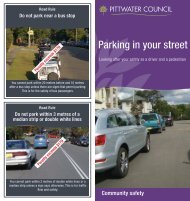
Vehicular Access and parking<br />
Limited parallel car parking is available on Narrabeen Park<br />
Parade. No parking fees are associated with this area.<br />
This plan of management expressly authorises the charging of<br />
parking fees in accordance with <strong>Council</strong>’s Policy No. 18 –<br />
‘Parking – Issue of Annual Permits’ (as determined by <strong>Council</strong><br />
from time to time) by automated ticketed parking systems.<br />
LEASES, LICENCES AND OTHER ESTATES<br />
Current<br />
There are no leases, licences or other estates applicable to<br />
Turimetta Beach at the time of preparation of this draft plan<br />
of management.<br />
Proposed<br />
This plan of management authorises the leasing, licensing or<br />
granting of any other estate over Turimetta Beach for any<br />
commercial activity that results in a diverse range of<br />
recreational activities or an activity that is deemed to be of<br />
community benefit being provided in the area.<br />
On condition that such activity or development;<br />
I. Is for a purpose that promotes or is related to the use and<br />
enjoyment of open space;<br />
II. Is consistent with the purposes for which the land was<br />
reserved or otherwise set aside for public use;<br />
III. Does not substantially diminish public use of or access to<br />
open space; and<br />
IV. Does not adversely affect the natural environment, the<br />
heritage significance of any heritage items or heritage<br />
conservation areas or the existing amenity of the area.<br />
Permissible Uses Table<br />
Table 6 identifies the major leases, licences and other estates<br />
for facilities proposed to be developed at Turimetta Beach.<br />
PROPOSED IMPROVEMENTS<br />
Master Plan<br />
The attached Master Plan for Turimetta Beach (refer Figure 7)<br />
has been developed to illustrate the works and<br />
improvements to the beach and surrounds that are required<br />
to address key management issues and objectives.<br />
Table 5<br />
Works Programme for Turimetta Beach<br />
Note Item Cost<br />
1 Sheep-station Lookout Viewing Deck $80,000<br />
1&5 Additional Seating / Picnic Tables $20,000<br />
3 Ongoing weed control $16,000<br />
Signage $20,000<br />
*<br />
TOTAL $136,000<br />
54
TABLE 6<br />
<strong>TURIMETTA</strong> PERMISSIBLE USES TABLE<br />
PERMISSIBLE USES NOT REQUIRING DEVELOPMENT CONSENT<br />
(These may require approval under Part V of the EPA Act 1979)<br />
USE/ ACTIVITY<br />
Advertising – temporary<br />
Alcohol-free zones r equiring consent of<br />
<strong>Council</strong> and c ons ent of ot her relevant<br />
committees i.e. Traffic C ommittee<br />
Consumpti on of alcohol in alcohol-free<br />
zones (providing appropriate<br />
signposting e.g. “The consumption of<br />
alcohol is prohibited without the<br />
express permission of Pit twater<br />
<strong>Council</strong>” is in exist enc e).<br />
Feral ani mal c ontrol and er adication<br />
Filming and still photography<br />
Maintenanc e / minor wor ks<br />
Pay par king facilities<br />
Picnics and barbecues and associated<br />
facilities<br />
Signage – c omplianc e, directional,<br />
interpretive, identification<br />
Surf life s aving acti vities & events,<br />
subject to r elevant appr ovals<br />
Temporar y ac tiviti es (excluding Surf<br />
Club events and oc ean s wims),<br />
developments or events that meet the<br />
criteria outlined i n Section 4 of this<br />
POM and require a cas ual booking or<br />
permit from <strong>Council</strong>, or a leas e or<br />
licence under the Crown Lands Act<br />
1989, that do not exceed one of the<br />
following criteria:<br />
The number of participants and/or<br />
spect ators on any one-day of an event<br />
does not exc eed 3000.<br />
Activiti es not occurring outsi de t he<br />
period of 7.30am t o 11. 30pm.<br />
Activities or temporar y facilities<br />
occur over a t ot al of more t han 7<br />
continuous days.<br />
Utility installations<br />
Vehicul ar access subject t o <strong>Council</strong><br />
approval<br />
In accordance with <strong>Council</strong>’s DCP.<br />
POLICY DET AILS / EXAMPL ES<br />
In acc ordance with <strong>Council</strong> Policy No. 93. ’Res erves, Beaches and<br />
Headlands Booking Policy’<br />
In acc ordance with <strong>Council</strong> Policy No.96 ‘Film Per mit Policy and<br />
Conditions – Amended September 2005’.<br />
Examples (including but not limited t o the f ollowing):<br />
- Bush r egeneration (including weed r emoval)<br />
- Dune s tabilisation, erosion control and foreshore protection<br />
- Earthwor ks t o c onstruc t struct ures identified on the Mast er Plan,<br />
including filling, levelling, grading and topdressing (e.g. installation of<br />
seating as per master plan)<br />
- Fencing including securit y, c hildpr oof, prot ecti ve and t emporar y<br />
fencing<br />
- Footpat hs, boardwalks , minor bridges, multi-use pathways and trac ks<br />
(other t han f or motor vehicles) – in accordance wit h t he M aster Pl an<br />
- Floodlighting of beach areas only for beach rel ated ac tiviti es<br />
- Fire hazard reduction acti vities<br />
- Land rest oration wor ks, i ncludi ng mounding – in acc ordance with the<br />
Master Plan<br />
- Landscaping – in acc ordance wit h the mast er plan<br />
- Lighting of res erve<br />
- Lookout viewing area upgrade – in accor danc e with the mast er plan<br />
- Minor drainage, stor mwat er, erosi on and sediment control wor ks<br />
- Park furnit ure, s uch as s eati ng, shade struct ures and s helt ers – i n<br />
accordance wit h t he Mas ter Pl an<br />
In acc ordance with <strong>Council</strong> Policy No. 18 ‘Parking – Iss ue of Annual<br />
Per mits – Waiving of Parking Fees’<br />
In acc ordance with <strong>Council</strong> Policy No. 129 ‘Signs – C ouncil’s Facilities’<br />
In acc ordance with <strong>Council</strong> Policy No. 24 ‘Beac h I nspec tor – Lif e Guard<br />
Service’ and <strong>Council</strong> Policy No. 88 ‘Beach and Rock pool Management’<br />
In acc ordance with <strong>Council</strong> Policy No.88 ‘Beach and Rock pool<br />
Management’ and <strong>Council</strong> Policy No. 93 ’Reserves, Beaches and<br />
Headlands Booking Policy’.<br />
In acc ordance with <strong>Council</strong> Policy No.88 ‘Beach and Rock pool<br />
Management’<br />
55
PERMISSIBLE USES REQUIRING DEVELOPMENT CONSENT<br />
Major Wor ks<br />
USE/ ACTIVITY<br />
Temporar y ac tiviti es (excluding Surf<br />
Club events and oc ean s wims),<br />
developments or events that meet the<br />
criteria outlined i n Section 4 of this<br />
Plan of Management and require a<br />
casual booking or permit from <strong>Council</strong>,<br />
or a lease or licenc e under the Crown<br />
Lands Ac t 1989, t hat exc eed one of t he<br />
following criteria:<br />
The number of participants and/or<br />
spect ators on any one-day of an event<br />
exceeds 3000.<br />
Activiti es occ urring outside t he<br />
period of 7.30am t o 11. 30pm.<br />
Activities or temporar y facilities<br />
occur over a t ot al of more t han 7<br />
continuous days.<br />
POLICY DET AILS / EXAMPL ES<br />
In acc ordance wit h t he Mas ter Pl an (including but not li mited to the<br />
following): -<br />
- Drainage and st ormwater wor ks (major, s uch as det enti on basin)<br />
- Filling or cutting greater than 500mm in depth<br />
In acc ordance with <strong>Council</strong> Policy No. 93 ’Res erves, Beac hes and<br />
Headlands Booking Policy’.<br />
PROHIBITED USES<br />
(Including but not limited to the following)<br />
- Advertising – per manent<br />
- Agriculture<br />
- Animals on the beac h with the exc eption of Guide Dogs for the visuall y i mpaired<br />
- Bus king<br />
- Domestic drainage outlets<br />
- Equestrian acti vities<br />
- Extracti ve i ndus tries<br />
- Gami ng<br />
- Privat e alienation or encroac hment<br />
- Recreational mot or vehicles, incl uding f our-wheel drivi ng, motorbi ke or tr ail bi ke riding, or similar, other than use<br />
for surf life saving and filming on a short ter m basis<br />
- Residential<br />
- Showground<br />
- Storage of watercraft or equipment bel ow Mean High Water Mar k<br />
- Unaut horised dumping of refus e incl uding building materials, soil, fill, garden wastes and the like ( other than<br />
importing of fill for per mitted wor ks)<br />
- Vegetation r emoval not in accordance with <strong>Council</strong>’s Tree Preser vation and Management Order, or this POM<br />
56
FIGURE 7<br />
57