Raport 2001 - 2002 - PaÅstwowy Instytut Geologiczny
Raport 2001 - 2002 - PaÅstwowy Instytut Geologiczny
Raport 2001 - 2002 - PaÅstwowy Instytut Geologiczny

You also want an ePaper? Increase the reach of your titles
YUMPU automatically turns print PDFs into web optimized ePapers that Google loves.
BIENNIAL REPORT<br />
i wielu dziedzinach geologii. Wersja cyfrowa mapy z cyfrowymi<br />
modelami terenu (DTM), obrazami satelitarnymi, zdjęciami lotniczymi<br />
oraz ortofotomapami jest doskonałym narzędziem do<br />
opracowywania wszechstronnych analiz geologicznych i środowiskowych.<br />
Stan realizacji SMGP na koniec <strong>2002</strong> r. był następujący:<br />
wykonano 801 arkuszy, co stanowi 78,14% całości<br />
edycji, zaś w opracowaniu znajdują się 74 arkusze.<br />
Zasady reambulacji Mapy geologicznej Polski (MGP)<br />
w skali 1:200 000. Podczas realizacji Szczegółowej mapy<br />
geologicznej Polski w skali 1:50 000 uzyskano wiele nowych<br />
istotnych informacji o budowie geologicznej kraju, które<br />
pozwalają obecnie na pełne zreambulowanie 43 arkuszy<br />
MGP w skali 1:200 000. Określono zasady i instrukcję reambulacji,<br />
a w celu sprawdzenia jej przydatności wykonano<br />
arkusz testowy Sejny. Opracowano mapę geologiczną utworów<br />
powierzchniowych, mapę geologiczną bez utworów czwartorzędowych,<br />
przekroje i profile geologiczne oraz objaśnienia<br />
tekstowe, w których szczegółowo opisano wydzielenia litologiczno-stratygraficzne.<br />
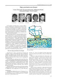
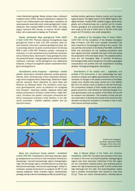
Geoindykatory strefy brzegowej – rejestracja i analiza<br />
zjawisk. Opracowano metodykę rejestracji i analizy geoindykatorów,<br />
które charakteryzują zmiany środowiska abiotycznego<br />
strefy brzegowej Morza Bałtyckiego. Badaniami objęto<br />
odcinek wybrzeża Zatoki Gdańskiej od ujścia Wisły pod<br />
Świbnem po Półwysep Helski. Przy określaniu zmian typowych<br />
geoindykatorów, jakimi są położenie linii brzegowej<br />
oraz transport i depozycja osadów, najlepsze efekty daje<br />
analiza porównawcza cyfrowych modeli terenu i zdjęć lotniczych.<br />
Umożliwia ona szybkie i precyzyjne uchwycenie tendencji<br />
rozwojowych wybrzeża w skali wieloleci, w tym obliczenie<br />
przyrostów i ubytków objętości osadów oraz powierzchni<br />
terenu.<br />
building industry, agriculture, forestry, tourism and many geological<br />
projects. The digital version of the SMGP together with<br />
digital elevation models (DTM), satellite imagery, aerial photographs<br />
and orthophotomaps are a perfect tool for comprehensive<br />
geological and environmental studies. 801 sheets<br />
were ready by the end of <strong>2002</strong> which is 78.14% of the total<br />
project and 74 sheets is now under preparation.<br />
The updating of the Geological Map of Poland (MGP),<br />
1:200 000. On the completion of the Detailed Geological<br />
Map of Poland, 1:50 000 much valuable information has<br />
been acquired on the geological setting of the country. This<br />
now permits a full revision of 43 sheets of the MGP, 1:200 000.<br />
Rules and instructions for the updating procedures have<br />
been agreed and their suitability has been confirmed during<br />
the preparation of the test Sejny sheet. The updated publications<br />
are: the Geological Map of Surficial Formations,<br />
the Geological Map without Quaternary Formations, geological<br />
cross-sections and profiles with text explanations including<br />
detailed lithological-stratigraphic descriptions.<br />
Geoindicators of the coastal zone – registration and<br />
analysis of the phenomena. A new methodology has been<br />
devised to analyse and register geoindicators which are characteristic<br />
of changes in the abiotic environment of the Baltic<br />
coastal zone. Studies have been carried out in the Gdańsk<br />
Bay from the Vistula mouth at Świbno to the Hel Peninsula.<br />
The comparative analysis of field models and aerial photographs<br />
proved the most effective for defining changes of typical<br />
geoindicators such as position of the shore line as well<br />
as transport and deposition. This enables a timely and precise<br />
observation of development trends of the shore line over<br />
decades including the evaluation of increase or loss in sediment<br />
volume and land surface.<br />
Zmiany linii brzegowej<br />
na stożku ujściowym Wisły<br />
Changes of the shore-line<br />
of the Vistula delta fan<br />
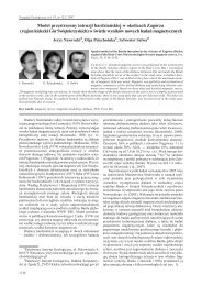
Mapa wód mineralnych Karpat polskich i ukraińskich<br />
w skali 1:500 000. Przedstawiono informacje dotyczące zasięgu<br />
występowania oraz chemizmu wód mineralnych wewnętrznokarpackiego<br />
i zewnętrznokarpackiego regionu hydrogeologicznego.<br />
Dla pierwszego regionu charakterystyczne są wody typu<br />
siarczanowo-sodowego i siarczanowo-wapniowego o niskiej mineralizacji,<br />
wysokiej temperaturze na wypływie (do 86°C) oraz<br />
wysokiej wydajności. Wody mineralne regionu zewnętrznokarpackiego<br />
cechuje zmienna mineralizacja (od kilku do ponad 50 g/l).<br />
Map of Mineral Waters of the Polish and Ukrainian<br />
Carpathians, 1:500 000. The extent and chemistry of the mineral<br />
waters in the Inner- and Outer-Carpathian hydrogeological<br />
regions have been described. Distinctive of the first region<br />
are low mineralized sulphate-sodium and sulphate-calcium<br />
waters with high temperatures (up to 86°C at the outflow) and<br />
high discharge from the wells. The Outer-Carpathian waters<br />
have a variable mineralization from several to more than<br />
50 g/l. These are mainly chloride-sodium, chloride-calcium<br />
9