Calgary Bow River Weir Project - Canadian Consulting Engineer
Calgary Bow River Weir Project - Canadian Consulting Engineer
Calgary Bow River Weir Project - Canadian Consulting Engineer

Create successful ePaper yourself
Turn your PDF publications into a flip-book with our unique Google optimized e-Paper software.
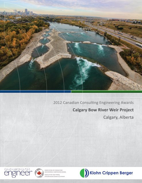
2012 <strong>Canadian</strong> <strong>Consulting</strong> <strong>Engineer</strong>ing Awards<br />
<strong>Calgary</strong> <strong>Bow</strong> <strong>River</strong> <strong>Weir</strong> <strong>Project</strong><br />
<strong>Calgary</strong>, Alberta
2012 CCE Awards Submission<br />
NAME OF MEMBER FIRM SUBMITTING<br />
Klohn Crippen Berger Ltd.<br />
ADDRESS OF FIRM<br />
500, 2618 Hopewell Place NE, <strong>Calgary</strong>, AB<br />
TEL FAX EMAIL<br />
403.274.3424 403.274.5349 cslack@klohn.com<br />
CONTACT NAME<br />
Chuck Slack, P.Eng.<br />
PROJECT TITLE<br />
Harvie Passage - <strong>Calgary</strong> <strong>Bow</strong> <strong>River</strong> <strong>Weir</strong> <strong>Project</strong><br />
LOCATION OF PROJECT<br />
<strong>Calgary</strong>, Alberta<br />
CATEGORY OF ENTRY<br />
Water Resources<br />
PROJECT CLIENT / OWNER<br />
Alberta Transportation / Alberta Environment and Water
<strong>Calgary</strong> <strong>Bow</strong> <strong>River</strong> <strong>Weir</strong><br />
Submitted by: Klohn Crippen Berger<br />
The primary purpose of the <strong>Calgary</strong> <strong>Bow</strong> <strong>River</strong> <strong>Weir</strong> project was to redevelop the weir to eliminate the extreme<br />
drowning hazard that it created and to enable river passage for non-motorized boats and fish while maintaining the<br />
Western Headwork’s primary function of facilitating diversion from the <strong>Bow</strong> <strong>River</strong> to the Western Irrigation District.<br />
Modifications to the weir could not result in increased river levels upstream of the weir during river floods up to<br />
the 1:100 year flood event and project aesthetics were to be in keeping with the natural beauty of the <strong>Bow</strong> <strong>River</strong>.<br />
Parks Foundation <strong>Calgary</strong> (PFC) commissioned the conceptual design of alternative design concepts to modify the<br />
<strong>Calgary</strong> <strong>Bow</strong> <strong>River</strong> <strong>Weir</strong>. PFC is a non-profit organization dedicated to the creation of parks, the preservation of<br />
river valleys, and the support of amateur sport. The conceptual design study concluded that a “full width manmade<br />
rapid” concept was a technically viable concept that offered the following significant benefits: increased<br />
safety and navigability; improved fish passage and habitat; reduced costs for Alberta Environment safety measures;<br />
reduced costs for the City of <strong>Calgary</strong> Fire Department Aquatic Rescue Unit, new recreational opportunities for<br />
whitewater boating, economic opportunities created by increased tourism to <strong>Calgary</strong> and area; and, aesthetic<br />
improvement as well as river, environment, and engineering educational opportunities.<br />
In 2006, Klohn Crippen Berger Ltd. (formerly Mack, Slack & Associates Inc.) in association with their hydraulic<br />
and ice subconsultant, Northwest Hydraulics Consultants (NHC), and their recreational hydraulics subconsultant,<br />
Recreation <strong>Engineer</strong>ing and Planning (REP), were retained by Alberta Transportation to undertake the final design,<br />
contracting services, construction contract administration and resident engineering services and commissioning of<br />
the project.<br />
To be able to continue its primary function of facilitating water diversions from the <strong>Bow</strong> <strong>River</strong> to the Western<br />
Irrigation District, the weir could not be removed, only modified. To improve safety and facilitate passage of<br />
non-motorized boats and fish, hydraulic constrictions (hereafter referred to as drop structures) were constructed<br />
downstream of the weir. The drop structures create a pool and riffle sequence resulting in higher water levels<br />
downstream of the weir; thereby, changing the hydraulics over the weir from a circulating hydraulic to linear. The<br />
hydraulic constrictions create energy through the riffles. The riffle geometry was designed to provide whitewater<br />
play areas for kayaking and river surfing thus making the safety improvements at the weir an amenity for the City of<br />
<strong>Calgary</strong>.<br />
Two channels were constructed downstream of the weir. The Low Water Channel (LWC) on river right consists of<br />
six concreted boulder drop structures and five constructed pools to provide a bypass channel for novice boaters to<br />
pass downstream. The High Water Channel (HWC), located in the centre and left side of the river, consists of five<br />
concreted boulder drop structures and three constructed pools. The HWC provides whitewater play areas for more<br />
experienced boaters. The LWC and HWC are separated by a constructed divide island which provides bird habitat<br />
and refuge for boaters.<br />
Fish passage enhancements include notches cut into the existing weir to facilitate boat and fish passage at low river<br />
flows, and lower velocity “fish passage channels” formed into the boulder-concreted surface of drop structures<br />
within the LWC and HWC. Fish passage boulders are incorporated in both the LWC and HWC drop structures.<br />
The islands and concreted-boulder drop structures are relatively low profile (i.e. do not project very high above the<br />
river) and are designed to be overtopped by river flood events greater than the 1:2 year flood; thereby, ensuring<br />
that flood levels upstream of the weir, in downtown <strong>Calgary</strong>, are not increased by the weir modifications.<br />
DESIGN - Hydraulic Modelling<br />
The hydraulic design of the project utilized comprehensive physical models and 2D numeric computer modelling<br />
to assess overall project hydraulics (i.e. water levels, velocities, flow patterns, flood conveyance, and irrigation<br />
diversion delivery) and drop structure hydraulics (i.e. velocities, flow patterns, fish passage, playwaves, and scour<br />
potential). Physical model testing was performed at NHC’s hydraulic laboratory in Edmonton. A comprehensive<br />
physical model of the entire project was constructed at a 1:50 scale. It reproduced an 850 m reach of the<br />
<strong>Bow</strong> <strong>River</strong>, extending approximately 350 m upstream and 500 m downstream of the existing weir. The model<br />
reproduced all pertinent features of the existing weir, canal headgate structure, sluiceway structure, and river<br />
channel bathymetry. The comprehensive model was used to validate and compare pre-project and post-project<br />
conditions for river discharges varying from a low flow of 44 m3/s up to the 1:100 year flood discharge of 2,750<br />
m3/s. In addition to the comprehensive models, flume models of individual LWC and HWC drop structures at<br />
scales of 1:15 for the LWC drops and 1:22 scale and 1:12 scale for the HWC drops were constructed to provide<br />
more detailed indication of the hydraulic performance of the drop structures. The flume models were capable
<strong>Calgary</strong> <strong>Bow</strong> <strong>River</strong> <strong>Weir</strong><br />
Submitted by: Klohn Crippen Berger<br />
of reproducing river discharges ranging from the low river flow of 44 m3/s to the 1:5 year flood discharge of 725<br />
m 3 /s.<br />
Civil<br />
The hydraulic design replicated in the physical model formed the basis for the sizing, geometry, and location of the<br />
drop structures, constructed pools, and islands. A comprehensive digital terrain model was created of the hydraulic<br />
model. This model aided in the generation of construction drawings, quantities and construction layout. The<br />
digital terrain model was subsequently used by the construction contractor for laying out the complex structures to<br />
a specified construction tolerance of ±25 mm.<br />
A key component of the design was to blend the weir modifications with the natural surroundings of the <strong>Bow</strong><br />
<strong>River</strong>. To do this required utilizing, as much as practicable, natural construction materials such as boulders,<br />
cobbles, and gravels. Conventional hydraulic structure designs with the desired design life of over 50 years would<br />
typically consist of man-made materials of reinforced concrete, structural steel, and/or steel sheet piles. To blend<br />
into the natural surroundings and to greatly increase the pace of construction, the design of the drop structures<br />
incorporated large, fieldstone boulders with macro-synthetic fibre reinforced concrete placed in the voids between<br />
the boulders for structural integrity and to reduce the risk of human limb entrapment. The concreted boulder<br />
structures more closely replicate natural riffles, outcrops, and bed materials that exist within the <strong>Bow</strong> <strong>River</strong>. Plastic<br />
fibre reinforcement was utilized to increase the tensile strength of the concrete to reduce thermal cracking of<br />
the concrete, provide structural integrity, and significantly accelerate construction. To allow barefoot pedestrian<br />
traffic on the structures, conventional steel fibre reinforcement was not applicable. Utilizing boulders with concrete<br />
in the voids provided very robust, cost effective structures with minimal foundation preparation resulting in<br />
faster construction with less care of water requirements and, ultimately, less construction impact on the aquatic<br />
environment than conventional reinforced concrete hydraulic structures.<br />
The LWC and HWC drop structures are subjected to: continuous and varying flow in a relatively turbulent hydraulic<br />
environment; varying differential heads; ice action/effects; and, frequent freeze/thaw and wet/dry cycles.<br />
Consequently, boulder sizing was a critical element of the design. Boulders varying in equivalent spherical diameter<br />
of 1 m (1.4 tonnes) to 1.8 m (8 tonnes) were incorporated in the design. Modifications to the western headworks<br />
structures included extending the vertical slot fishway wall 60 m downstream to confine the pool downstream of<br />
the weir. Also, modifications to the existing weir included removing portions of the weir at four locations to create<br />
notches or entranceways into the LWC and HWC and constructing a 4 m long cast-in-place concrete section with<br />
a vertical drop along the downstream side of the weir to significantly reduce the submerged roller or circulating<br />
hydraulic.<br />
The project was tendered in the summer of 2008 and was awarded to the low bidder, DeGraaf Excavating Ltd.<br />
(DGE) of Lethbridge, Alberta, for $16.6 million.<br />
CONSTRUCTION<br />
Construction started in December 2008 with the isolation and construction of the extension of the fishway wall<br />
which was completed in April 2009.<br />
After completion of the fishway wall, in-stream construction structures were restricted from April 6th to 30th<br />
and July 15th to September 15th each year. In August 2009, DGE entered the river to construct cofferdams and<br />
a temporary diversion channel around three of the HWC drop structures and around the entrance to the LWC.<br />
Construction of the three HWC drop structures and entrance to the LWC was completed in April 2010. In April<br />
cofferdams were constructed to isolate the LWC to facilitate construction of the LWC which was completed in<br />
August 2010. Cofferdams were constructed to isolate the river on the remaining two HWC drop structures in<br />
September 2010 with construction being completed in November 2010. Cofferdams were removed in April 2011<br />
and the project was fully functional on April 30, 2011. Construction was completed on schedule and under-budget.<br />
Performance testing has been ongoing since May 2011. Swimmers, canoeists, kayakers, inflatable rafts and floaters<br />
have floated through and played on the drop structures. The weir was a safety hazard. Its transformation improves<br />
safety, fish passage, and creates an amenity to new users including canoeists, kayakers, bird watchers, educators,<br />
floaters, pathway users and picnickers.
2012 CCE Awards Submission <strong>Project</strong> Description<br />
<strong>Project</strong> History<br />
The Western Headworks (WH) was constructed by<br />
the <strong>Canadian</strong> Pacific Railroad (CPR) in 1908 to divert<br />
water from the <strong>Bow</strong> <strong>River</strong> to the semi-arid region east<br />
of <strong>Calgary</strong>. The diverted water was, and continues to<br />
be, used for irrigated agriculture, livestock watering,<br />
municipal, and recreation, and served a pivotal<br />
role in the settling of Alberta and the population<br />
growth of <strong>Calgary</strong> and surrounding area. The original<br />
headworks structure, located on the <strong>Bow</strong> <strong>River</strong> within<br />
the Inglewood district of the City of <strong>Calgary</strong> near<br />
<strong>Project</strong> location plan<br />
the current day intersection of Memorial Drive and<br />
Deerfoot Trail S.E., was constructed of timber. The weir and sluiceway structure were<br />
replaced with reinforced concrete structures in 1924. The 1924 diversion structure to<br />
the WH Canal remains today and has been designated an Alberta Heritage Site.<br />
The 1924 structures were replaced by the Prairie Farm Rehabilitation Administration<br />
(PFRA), a division of Agriculture Canada, in 1975 and are now owned and operated<br />
by Alberta Environment and Water (AEW). The current headworks include a headgate<br />
structure (diverts water from the <strong>Bow</strong> <strong>River</strong> to the Western Irrigation District); a 152.4<br />
m long x 2.6 m high ogee weir structure (the “<strong>Calgary</strong> <strong>Weir</strong>”); a sluiceway structure<br />
(used to divert the <strong>Bow</strong> <strong>River</strong> around the weir in the fall and winter); and, a vertical slot<br />
fishway structure located on the river left (north) end of the weir.<br />
The “<strong>Calgary</strong> <strong>Weir</strong>” represented the only barrier to boaters and fish passage in the<br />
100 km section of the <strong>Bow</strong> <strong>River</strong> between the Bearspaw Dam, located at the western<br />
limits of <strong>Calgary</strong>, and the Carseland-<strong>Bow</strong> <strong>River</strong> Headworks, located near the Village<br />
of Carseland, east of <strong>Calgary</strong>. The weir includes an ogee weir profile (like a ski-jump)<br />
which created a submerged roller or circulating hydraulic to reduce energy and flow<br />
velocities downstream of the weir. Since it’s construction, over 20 people have perished<br />
going over the weir as it is extremely difficult to swim out of the circulating hydraulic.<br />
Consequently, the “<strong>Calgary</strong> <strong>Weir</strong>” was named, with corresponding signage on site, the<br />
“Drowning Machine”.<br />
Incorporating a fish ladder at the weir was quite progressive when the weir was<br />
commissioned in 1975. However, the 1.5 m wide vertical slot fishway had insufficient<br />
attraction flow to facilitate successful upstream fish passage on the 180 m wide <strong>Bow</strong><br />
<strong>River</strong>. Fish populations were identified to be significantly different downstream and<br />
upstream of the weir, indicating that the weir was an obstruction to fish movement. The<br />
fish obstruction has resulted in the area downstream of the weir being a popular feeding<br />
area for pelicans and cormorants.<br />
1
.<br />
2012 CCE Awards Submission <strong>Project</strong> Description<br />
<strong>Project</strong> Overview<br />
The primary purpose of the <strong>Calgary</strong> <strong>Bow</strong> <strong>River</strong> <strong>Weir</strong><br />
<strong>Project</strong> was to redevelop the weir to eliminate the<br />
extreme drowning hazard that it created and to enable<br />
river passage for non-motorized boats and fish while<br />
maintaining the Western Headwork’s primary function<br />
of facilitating diversion from the <strong>Bow</strong> <strong>River</strong> to the<br />
Western Irrigation District. Modifications to the weir<br />
could not result in increased river levels upstream of<br />
the weir during river floods up to the 1:100 year flood<br />
event and project aesthetics were to be in keeping with<br />
the natural beauty of the <strong>Bow</strong> <strong>River</strong>.<br />
Warning sign (pre-construction)<br />
To this end, Parks Foundation <strong>Calgary</strong> (PFC)<br />
commissioned the conceptual design of alternative<br />
design concepts to modify the <strong>Calgary</strong> <strong>Weir</strong>. PFC is a<br />
non-profit organization dedicated to the creation of<br />
parks, the preservation of river valleys, and the support<br />
of amateur sport. The PFC was instrumental in the<br />
planning, vision, and fund-raising for the <strong>Calgary</strong> <strong>Bow</strong><br />
<strong>River</strong> <strong>Weir</strong> <strong>Project</strong>.<br />
The conceptual design study concluded that a “full<br />
width man-made rapid” concept was a technically<br />
viable concept with multiple benefits.<br />
<strong>Calgary</strong> fire department simulated rescue<br />
featured on the Discovery Channel Daily<br />
Planet (2009)<br />
The preliminary design of the <strong>Calgary</strong> <strong>Bow</strong> <strong>River</strong><br />
<strong>Weir</strong> <strong>Project</strong> was undertaken by Golder Associates,<br />
Northwest Hydraulic Consultants (NHC) and Recreation<br />
<strong>Engineer</strong>ing and Planning (REP) to further develop and<br />
confirm the dimensional design elements for the “full<br />
width rapid” concept. NHC of Edmonton carried out<br />
physical model studies to confirm the project hydraulic<br />
and safety performance, confirm irrigation diversion<br />
capability, and to assess non-motorized boat and fish<br />
passage and REP of Boulder, Colorado provided expert<br />
Benefits of design concept<br />
• Increased safety and navigability.<br />
• Improved fish passage and habitat.<br />
• Reduced costs for Alberta Environment safety<br />
measures.<br />
• Reduced costs for the City of <strong>Calgary</strong> Fire<br />
Department Aquatic Rescue Unit.<br />
• New recreational opportunities for<br />
whitewater boating.<br />
• Economic opportunities created by<br />
increased tourism to <strong>Calgary</strong> and area.<br />
• Aesthetic improvement as well as river,<br />
environment, and engineering educational<br />
opportunities.<br />
2
.<br />
2012 CCE Awards Submission <strong>Project</strong> Description<br />
input to the project configuration during the physical modelling with particular emphasis<br />
on the design of the whitewater play features. The results of the physical model studies,<br />
completed in 2006, were subsequently used to develop final designs for the required<br />
works, including modifications to the existing structures.<br />
In 2006, Klohn Crippen Berger (formerly Mack, Slack & Associates Inc.) in association<br />
with their hydraulic and ice subconsultant, NHC, and their recreational hydraulics<br />
subconsultant, REP, were retained to undertake the final design, contracting services,<br />
construction contract administration and resident engineering services of the project.<br />
The project was carried out under direction from the<br />
PFC, Alberta Transportation (AT), The City of <strong>Calgary</strong><br />
(City), and AEW. AT was the project manager for the<br />
project and played an instrumental role in design,<br />
tendering, construction, and commissioning.<br />
<strong>Weir</strong> pre-project (2008)<br />
Artist’s drawing - courtesy of PFC<br />
To be able to continue its primary function of facilitating<br />
water diversions from the <strong>Bow</strong> <strong>River</strong> to the Western<br />
Irrigation District, the weir could not be removed.<br />
Rather, the modified weir remains. To improve safety<br />
and facilitate passage of non-motorized boats and fish,<br />
hydraulic constrictions (hereafter referred to as drop<br />
structures) were constructed downstream of the weir.<br />
The hydraulic constrictions create a pool and riffle<br />
sequence resulting in higher water levels downstream of<br />
the weir; thereby, changing the hydraulics over the weir<br />
from a circulating hydraulic to linear.<br />
The hydraulic constrictions create energy through the<br />
riffles. The riffle geometry was designed to provide<br />
whitewater play areas for kayaking and river surfing thus<br />
making the safety improvements at the weir an amenity<br />
for the City of <strong>Calgary</strong>.<br />
Two channels were constructed downstream of the<br />
weir. The Low Water Channel (LWC) on river right consists of six concreted boulder drop<br />
structures and five constructed pools to provide a bypass channel for novice boaters to<br />
pass downstream. The High Water Channel (HWC), located in the centre and left side of<br />
the river, consists of five concreted boulder drop structures and three constructed pools.<br />
The HWC provides whitewater play areas for more experienced boaters. The LWC and<br />
HWC are separated by a constructed divide island which provides habitat for birds and<br />
refuge for boaters.<br />
Fish passage enhancements include notches cut into the existing weir to facilitate boat<br />
and fish passage at low river flows, and lower velocity “fish passage channels” formed<br />
into the boulder-concreted surface of drop structures within the LWC and HWC. Fish<br />
passage boulders are incorporated in both the LWC and HWC drop structures.<br />
The height of the islands and concreted-boulder drop structures are relatively low profile<br />
(i.e. do not project very high above the river) and are designed to be overtopped by river<br />
3
2012 CCE Awards Submission <strong>Project</strong> Description<br />
flood events greater than the 1:2 year flood; thereby,<br />
ensuring that flood levels upstream of the weir are not<br />
increased by the weir modifications.<br />
Design<br />
Hydraulic Modelling<br />
Comprehensive physical model (1:50 scale)<br />
- courtesy of NHC (2006)<br />
HWC Drop #3R flume model<br />
Digital terrian model of projects<br />
Placing boulder concrete (September, 2009)<br />
The hydraulic design of the project utilized<br />
comprehensive physical models and 2D numeric<br />
computer modelling to assess overall project hydraulics<br />
(i.e. water levels, velocities, flow patterns, flood<br />
conveyance, and irrigation diversion delivery) and drop<br />
structure hydraulics (i.e. velocities, flow patterns, fish<br />
passage, playwaves, and scour potential). Physical<br />
model testing was performed at NHC’s hydraulic<br />
laboratory in Edmonton. A comprehensive physical<br />
model of the entire project was constructed at a<br />
1:50 scale. It reproduced an 850 m reach of the <strong>Bow</strong><br />
<strong>River</strong>, extending approximately 350 m upstream and<br />
500 m downstream of the existing weir. The model<br />
reproduced all pertinent features of the existing weir,<br />
canal headgate structure, sluiceway structure, and river<br />
channel bathymetry. The comprehensive model was<br />
used to validate and compare pre-project and postproject<br />
conditions for river discharges varying from a<br />
low flow of 44 m 3 /s up to the 1:100 year flood discharge<br />
of 2,750 m 3 /s. In addition to the comprehensive<br />
models, flume models of individual LWC and HWC<br />
drop structures at scales of 1:15 for the LWC drops<br />
and 1:22 scale and 1:12 scale for the HWC drops were<br />
constructed to provide more detailed indication of<br />
the hydraulic performance of the drop structures.<br />
The flume models were capable of reproducing river<br />
discharges ranging from the low flow of 44 m 3 /s to the<br />
1:5 year flood discharge of 725 m 3 /s.<br />
Civil <strong>Engineer</strong>ing<br />
The hydraulic design replicated in the physical model<br />
formed the basis for the sizing, geometry, and location<br />
of the drop structures, constructed pools, and islands.<br />
A comprehensive digital terrain model was created of<br />
the hydraulic model. This model aided in the generation<br />
of construction drawings, quantities and construction<br />
layout. The digital terrain model was subsequently<br />
4
2012 CCE Awards Submission <strong>Project</strong> Description<br />
<strong>Project</strong> General Arrangement Plan<br />
5
2012 CCE Awards Submission <strong>Project</strong> Description<br />
<strong>Project</strong> was designed to blend with nature<br />
Fishway boulders in HWC Drop #2L,<br />
(September, 2010)<br />
LWC Drop #2 construction (June, 2010)<br />
Half of HWC Drop #4 (October, 2010)<br />
used by the construction contractor for laying out the<br />
complex structures to a specified construction tolerance<br />
of ±25 mm.<br />
A key component of the design was to blend the weir<br />
modifications with the natural surroundings of the<br />
<strong>Bow</strong> <strong>River</strong>. To do this required utilizing, as much as<br />
practicable, natural construction materials such as<br />
boulders, cobbles, and gravels. Conventional hydraulic<br />
structure designs with the desired design life of over<br />
50 years would consist of man-made materials of<br />
reinforced concrete, structural steel, and/or steel sheet<br />
piles. To blend into the natural surroundings and to<br />
greatly increase the pace of construction, the design<br />
of the drop structures incorporated large, fieldstone<br />
boulders with macro-synthetic fibre reinforced<br />
concrete placed in the voids between the boulders for<br />
structural integrity and to reduce the risk of human<br />
limb entrapment. The concreted boulder structures<br />
more closely replicate natural riffles, outcrops, and<br />
bed materials that exist within the <strong>Bow</strong> <strong>River</strong>. Plastic<br />
fibre reinforcement was utilized to increase the tensile<br />
strength of the concrete to reduce thermal cracking<br />
of the concrete, provide structural integrity, and<br />
significantly accelerate construction. To allow barefoot<br />
pedestrian traffic on the structures, conventional<br />
steel fibre reinforcement was not applicable. Utilizing<br />
boulders with concrete in the voids provided very<br />
robust, cost effective structures with minimal<br />
foundation preparation resulting in faster construction<br />
with less care of water requirements and, ultimately,<br />
less construction impact on the aquatic environment<br />
than conventional reinforced concrete hydraulic<br />
structures.<br />
The LWC and HWC drop structures are subjected to:<br />
continuous and varying flow in a relatively turbulent<br />
hydraulic environment; varying differential heads; ice<br />
action/effects; and, frequent freeze/thaw and wet/<br />
dry cycles. Consequently, boulder sizing was a critical<br />
element of the design. Boulders varying in equivalent<br />
spherical diameter of 1 m (1.4 tonnes) to 1.8 m (8<br />
tonnes) were incorporated in the design.<br />
Modifications to the WH structures included extending<br />
the vertical slot fishway wall 60 m downstream<br />
6
2012 CCE Awards Submission <strong>Project</strong> Description<br />
HWC Drop #2L profile<br />
to confine the pool downstream of the weir. Also, modifications to the existing<br />
weir included removing portions of the weir at four locations to create notches or<br />
entranceways into the LWC and HWC and constructing a 4 m long cast-in-place concrete<br />
section with a vertical drop along the downstream side of the weir to significantly reduce<br />
the submerged roller or circulating hydraulic.<br />
Tendering<br />
The project was tendered in the summer of 2008. Bids were closed on August 28, 2008<br />
and the construction contract was awarded for $16.6 million to the low bidder, DeGraaf<br />
Excavating Ltd. (DGE) of Lethbridge.<br />
The project was privately funded with significant contributions by the Harvie family (the<br />
<strong>Calgary</strong> <strong>Bow</strong> <strong>River</strong> <strong>Weir</strong> <strong>Project</strong> is named Harvie Passage), <strong>Calgary</strong> Foundation, The City<br />
of <strong>Calgary</strong>, Alberta Lottery Fund, Alberta Environment, and Alberta Transportation.<br />
Construction<br />
Construction started in December 2008 with the isolation<br />
and construction of the extension of the fishway wall which<br />
was completed in April 2009.<br />
After completion of the fishway wall, in-stream construction<br />
activities were restricted to April 6th to 30th, and July 15th<br />
to September 15th each year. Construction activities ceased<br />
from May 2009 to August 2009 at which time DGE entered<br />
the river to construct cofferdams and a temporary diversion<br />
channel around HWC Drop #3L, #3R, and #4 and to isolate<br />
Extension of fishway wall (April, 2009)<br />
the entrance to the LWC. Construction of HWC Drop #3L,<br />
#3R and #4 were completed at the end of November. Construction of the entrance to<br />
the LWC (LWC Drop #1) was completed on April 14, 2010 and water was diverted over<br />
HWC Drops #3L, #3R and #4 for the first time on April 15, 2010.<br />
In April 2010, cofferdams were constructed to isolate the LWC. Construction of LWC<br />
Drops #2 to #6 and LWC pools #1 to #5 started in April 2010 and were completed in<br />
August 2010.<br />
Cofferdams were constructed to isolate the weir and HWC Drops #2L and #2R in<br />
September 2010. Construction of HWC Drops #2L and #2R were completed on October<br />
22, 2010 and the weir modifications were completed on November 12, 2010.<br />
7
2012 CCE Awards Submission <strong>Project</strong> Description<br />
<strong>Bow</strong> <strong>River</strong> diversion/construction of HWC<br />
Drops #1, #2L and #2R (October 2010)<br />
The cofferdams were removed in April 2011 and the<br />
project was fully functional on April 30, 2011.<br />
Approximately 5,500 willow, dogwood and balsam<br />
poplar cuttings were planted on top of the divide<br />
island and along the left abutments of HWC Drop #3L<br />
and #4 in late April.<br />
Construction was completed on schedule and under<br />
budget.<br />
<strong>Project</strong> Commissioning<br />
Performance testing started on HWC Drop #3L, #3R,<br />
and #4 in the summer of 2010 and continued on the<br />
entire project in May and June of 2011. Swimmer’s,<br />
canoeists, kayakers, inflatable rafts, the <strong>Calgary</strong> Fire<br />
Department Aquatic Rescue Team, and floaters have<br />
floated through and played on the LWC and HWC<br />
Drop structures. Performance testing is ongoing as it<br />
is desired to test the structures through the full range<br />
of <strong>Bow</strong> <strong>River</strong> flows.<br />
<strong>Weir</strong> modfications (October, 2010)<br />
Concrete debris fishway (April 2010)<br />
Planting on Divide Island (April, 2011)<br />
Velocity measurements in river diversion<br />
<strong>Bow</strong> <strong>River</strong> diversion HWC Drop #3L, #3R and<br />
#4 construction (October 2009)<br />
8
2012 CCE Awards Submission <strong>Project</strong> Description<br />
Collaboration<br />
Kayaker testing<br />
<strong>River</strong> raft testing<br />
Floater testing<br />
The <strong>Calgary</strong> <strong>Bow</strong> <strong>River</strong> <strong>Weir</strong> <strong>Project</strong> was a<br />
challenging and unusual project. Similar whitewater<br />
features to those incorporated in this project have<br />
been constructed elsewhere in North America<br />
(predominantly in the United States) but not on a<br />
river of this size or on a river with varying discharge<br />
and harsh ice regime as the <strong>Bow</strong> <strong>River</strong>.<br />
Constructing a project that spans the entire width of<br />
the river presented interesting challenges. Limiting<br />
the impact of 30 months of construction on the<br />
aquatic environment was considered extensively in<br />
the design, as well as the selection of construction<br />
materials, construction methodology, technical<br />
specifications, construction activities and scheduling.<br />
Clean gravel cofferdams, turbidity curtains, settling<br />
ponds, erosion protection, numerous fish salvages,<br />
fish screens on dewatering pump intakes, provision of<br />
wildlife corridors through the construction site, and<br />
provision of upstream fish passage through all stages<br />
of construction attempted to reduce impacts on the<br />
adjacent environment. Collaboration with Alberta<br />
Transportation, Parks Foundation <strong>Calgary</strong>, regulatory<br />
agencies, stakeholders and the construction<br />
contractor (DGE) was essential to the successful<br />
completion of this project. Their input, guidance, and<br />
support is acknowledged and appreciated.<br />
The weir was a safety hazard. Its transformation<br />
improves safety and fish passage and creates an<br />
amenity to river users including canoeists, kayakers,<br />
bird watchers, educators, floaters, pathway users, and<br />
picnickers.<br />
Low water channel<br />
Kayakers testing the rapids<br />
9