Lower Washita - Water Resources Board - State of Oklahoma
Lower Washita - Water Resources Board - State of Oklahoma
Lower Washita - Water Resources Board - State of Oklahoma

Create successful ePaper yourself
Turn your PDF publications into a flip-book with our unique Google optimized e-Paper software.
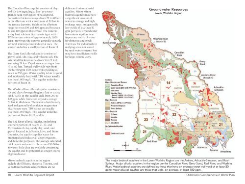
The Canadian River aquifer consists <strong>of</strong> clay<br />
and silt downgrading to fine- to coarsegrained<br />
sand with lenses <strong>of</strong> basal gravel.<br />
Formation thickness ranges from 20 to 40 feet<br />
in the alluvium with a maximum <strong>of</strong> 50 feet in<br />
the terrace deposits. Yields in the alluvium<br />
range between 100 and 400 gpm and between<br />
50 and 100 gpm in the terrace. The water is<br />
a very hard calcium bicarbonate type with<br />
TDS concentrations <strong>of</strong> approximately 1,000<br />
mg/L. However, the water is generally suitable<br />
for most municipal and industrial uses. The<br />
aquifer underlies a small portion <strong>of</strong> Basin 15.<br />
The Gerty Sand alluvial aquifer consists <strong>of</strong><br />
gravel, sand, silt, clay, and volcanic ash. The<br />
saturated thickness varies from 5 to 75 feet,<br />
averaging 28 feet. Depth to water ranges from<br />
10 to 110 feet. Typical well yields vary from<br />
100 to 450 gpm with some wells yielding as<br />
much as 850 gpm. <strong>Water</strong> quality is fair to good<br />
and moderately hard with TDS values usually<br />
less than 1,000 mg/L. This aquifer underlies<br />
portions <strong>of</strong> Basin 14.<br />
The <strong>Washita</strong> River alluvial aquifer consists <strong>of</strong><br />
silt and clays downgrading into fine to coarse<br />
sand. Wells in this aquifer yield from 200 to<br />
500 gpm, while formation deposits average<br />
70 feet in thickness. The water is hard to very<br />
hard and generally <strong>of</strong> a calcium magnesium<br />
bicarbonate type. TDS values are usually<br />
less than 1,000 mg/L. This aquifer underlies<br />
portions <strong>of</strong> Basins 14, 15, and 16.<br />
The Red River alluvial aquifer, underlying<br />
southern portions <strong>of</strong> basins 21, 22, and<br />
23, consists <strong>of</strong> clay, sandy clay, sand, and<br />
gravel. Located in Jefferson, Love, and Bryan<br />
Counties, the aquifer supplies water for<br />
Municipal and Industrial, Crop Irrigation,<br />
and domestic purposes. The average saturated<br />
thickness is estimated to be around 20-30 feet;<br />
however, little data are available concerning<br />
the aquifer and its potential as a major source<br />
<strong>of</strong> groundwater.<br />
delineated minor alluvial<br />
aquifers. Minor Minor<br />
bedrock aquifers may have<br />
a significant amount <strong>of</strong><br />
water in storage and high<br />
recharge rates, but generally<br />
low yields <strong>of</strong> less than 50<br />
gpm per well. Groundwater<br />
from minor aquifers is an<br />
important source <strong>of</strong> water<br />
for domestic and stock<br />
water use for individuals in<br />
outlying areas not served<br />
by rural water systems, but<br />
may have insufficient yields<br />
for large-volume users.<br />
Groundwater <strong>Resources</strong><br />
<strong>Lower</strong> <strong>Washita</strong> Region<br />
Minor bedrock aquifers in the region<br />
include the El Reno, Marietta, Texoma, and<br />
Woodbine bedrock aquifers; there are no<br />
The major bedrock aquifers in the <strong>Lower</strong> <strong>Washita</strong> Region are the Antlers, Arbuckle-Simpson, and Rush<br />
Springs. Major alluvial aquifers in the region are the Canadian River, Gerty Sand, Red River, and <strong>Washita</strong><br />
River. Major bedrock aquifers are defined as those that have an average water well yield <strong>of</strong> at least 50<br />
gpm; major alluvial aquifers are those that yield, on average, at least 150 gpm.<br />
10 <strong>Lower</strong> <strong>Washita</strong> Regional Report <strong>Oklahoma</strong> Comprehensive <strong>Water</strong> Plan


![A Commodity & a Resource [pdf] - Water Resources Board - State of ...](https://img.yumpu.com/42536671/1/190x143/a-commodity-a-resource-pdf-water-resources-board-state-of-.jpg?quality=85)