Internal page lay out

You also want an ePaper? Increase the reach of your titles
YUMPU automatically turns print PDFs into web optimized ePapers that Google loves.
Chapter 1: Identification of the Property ...........................................3<br />
1.A Country<br />
1.B. Province and Location of the Site.......................................................3<br />
1.C. Name of the Site<br />
1.D. Geographical Characteristics of the Site<br />
1.E. Map and Plan, Showing the Boundaries of the Nominated<br />
Property and Buffer Zone<br />
1.F. Area of Nominated Property (ha.) and Proposed Buffer<br />
Zone(ha.)<br />
Chapter 2: Description ..............................................................................3<br />
2. A: The Description of the work<br />
Foreword<br />
The nature of cultural landscape of Maymand<br />
Geology and the condition of the soil<br />
Water resources<br />
Climate and altitude<br />
Flora and fauna<br />
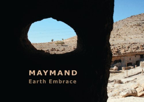
Maymand Earth Embrace<br />
Index<br />
i
Animals<br />
Natural characteristics<br />
Natural attractions<br />
Man in interaction with nature<br />
Social structure and lifestyle<br />
Architecture<br />
o Sar-e-āghol<br />
Climate<br />
Lifestyle<br />
Structures and spaces<br />
Domestic animals’ spaces<br />
• Break folds (Sūl)<br />
• Wooden folds<br />
• Kūz and darkūz<br />
• Korom<br />
• Talgard<br />
• Jīrehdān<br />
• Sheep Prison (zendān-e-Gūsfand)<br />
Human spaces<br />
• Kapar<br />
• Markhāneh<br />
• Mashkdān<br />
• Water pool<br />
o Sar-e-baagh<br />
Climate<br />
Lifestyle<br />
Structures and spaces<br />
ii<br />
Index<br />
Maymand Earth Embrace
Human spaces<br />
• Kapar<br />
• Gombeh<br />
• Mashkdān<br />
• Chahārpāyeh<br />
• Kel-e-dūshāb<br />
• Mill<br />
• Kharman- kamarī<br />
Domestic animals’ spaces<br />
• Keleh<br />
• Parvārband<br />
• Talgard<br />
Beekeeping<br />
Eshām<br />
• Pelās<br />
o Troglodyte Maymand<br />
Climate<br />
Lifestyle<br />
Introducing Troglodyte Maymand<br />
Access r<strong>out</strong>es to village fabric<br />
• Tarmac r<strong>out</strong>es<br />
• Dust r<strong>out</strong>es<br />
• Dry river (masīl) in the middle of the village<br />
• Kāshkor<br />
• Rekhneh<br />
• Stone steps<br />
Quarter’s Centre<br />
Living Units<br />
Maymand Earth Embrace<br />
Index<br />
iii
Chapter 1: Identification of the Property<br />
1.A Country<br />
Iran<br />
1.B. Province and Location of the Site<br />
Kerman Province, Shahr-e Babak Township<br />
1.C. Name of the Site<br />
Cultural Landscape of Maymand<br />
1.D. Geographical Characteristics of the Site<br />
The cultural landscape of Maymand covers an extended area with the following<br />
geographical coordinates:<br />
Chapter One Page<br />
2<br />
Maymand Earth Embrace
Fig. 1E.4 Sar-e-āghol<br />
Fig. 1E.3 Eshām<br />
Map. 1E.1Cultural landscape of Maymand<br />
Fig. 1E.2 Troglodyte<br />
Maymand Fig. 1E.1 Sar-e-Bāgh<br />
Maymand Earth Embrace<br />
Chapter One Page<br />
5
Buffer and Core Zones:<br />
Buffer and core zones of the Maymand cultural landscape is defined based on its particular conditions. This cultural landscape<br />
consists of troglodyte village of Maymand, Sar-e-Bāghs and Sar-e-Āghols, natural sites such as a cave as well as miscellaneous<br />
sites like mills, castle, Pre-Islamic Graves, qanat and so on. Life in Maymand involves all these elements and therefore all of<br />
them are introduced as the core zone of the site, while a larger area including other related features that in some cases have<br />
similarities with elements of Maymand cultural landscape forms its buffer zone. Specific set of regulation and policies are set<br />
for each of these zones in order to preserve and protect the life based on the stable development plans. Below is a description<br />
of defined regulation and policies.<br />
Core zone Regulations and Policies:<br />
Limit of the site’s core zone is drawn on the natural features around the village and is shown by a thick line on the map.<br />
1- Any activity that caused any damage or destruction in this zone is prohibited.<br />
2- Any construction, building and rod making activity in the core zone of the site is prohibited. Any repairmen, extension<br />
or revitalization of old passage ways and r<strong>out</strong>es is only permitted after submission of a proper proposal to the Cultural<br />
Heritage Organization and after its final approval.<br />
3- Any research, developmental and organizing activity in order to protect and preserve the historical and cultural values of<br />
the village including any restoration, revitalization, extension, repairmen, alteration or functional change in all or parts of<br />
the core zone is permitted after submission of a proper proposal to the Cultural Heritage Organization and after its final<br />
approval; and by considering and careful following of the approved proposal details.<br />
4- Utilizing springs and rivers and irrigation of agricultural lands and gardens is permitted as long as they don’t affect and<br />
Chapter One Page<br />
6<br />
Maymand Earth Embrace
damage the natural landscape of the site.<br />
5- Extraction of stone and sand mines, cutting mountains and leveling of or excavation in the lands is prohibited in this zone.<br />
6- Fundamental development plans such as establishment of electricity and telephone lines, gas, water and sewage pipes<br />
and so on is only permitted and performable after submission of a specific project proposal and its final approval by the<br />
Cultural Heritage Organization.<br />
7- No public and heavy vehicle can enter the village.<br />
8- Cultural Heritage Organization has unrestricted right for all the scientific and archaeological projects and supervising all<br />
projects after their final approval.<br />
9- Historical towers located in the mountains and historical cemeteries located in the core zone of the site are considered<br />
valuable element and should be protected and restored.<br />
10- It is mandatory to protect and conserve all the agricultural lands and gardens located in the core zone of the site; the<br />
involved activities are, however, allowed.<br />
11- The newly built buildings of education ministry camp, the telephone and communication office, health center and school<br />
that are located in the core zone must be demolished as they damage the sites’ visual perspective.<br />
Buffer Zone Regulation and Policies:<br />
The Buffer zone of the site includes the natural context and the important, valuable and affecting element located within it.<br />
Buffer zone limits will be shown on the map and its related regulations and policies will be announced and supervised by<br />
the Cultural Heritage Organization.<br />
Maymand Earth Embrace<br />
Chapter One Page<br />
7
1.F. Area of Nominated<br />
Property (ha.) and<br />
Proposed Buffer Zone(ha.)<br />
Map. 1F.1 Core zone and buffer zone of cultral landscape of Maymand<br />
Core zone of the cultural landscape<br />
of Maymand covers an area of<br />
22500 hectares and buffer zone of<br />
Maymand covers an area of 44900<br />
hectares.<br />
Core and buffer zones of the site<br />
included the village itself plus all the<br />
natural and man-made features in<br />
its vicinity; these are located in an<br />
area measuring ab<strong>out</strong> 28000 meters<br />
from north to s<strong>out</strong>h and ab<strong>out</strong><br />
24000 meters from west to east.<br />
Chapter One Page<br />
8<br />
Maymand Earth Embrace
Water Resources:<br />
Maymand’s water resources can be divided into a number of sections:<br />
Fig.2.1 Ney- rizoo spring: the upper kel- e- ow is<br />
covered to be used by people while the lower one is allocated<br />
to farm animals.<br />
1- Subterranean water resources including water springs and Qanats<br />
(subterranean):<br />
In total, there are 26 water springs,<br />
21 of which belong to Maymand. The<br />
closest one to the village is Ney-rīzū<br />
which supplies water through<strong>out</strong> the<br />
whole year. As for subterranean water<br />
canals or Qanats (), 51 are known<br />
whose water is used for irrigation of<br />
farms and orchards as well as for the<br />
use of villagers and their farm animals.<br />
23 of these Qanats () are situated within<br />
the bigger Maymand area while two are<br />
inside the village itself, the closets one<br />
to the village being Had-Konūīyeh5.<br />
(Fig.2.1-2.2)<br />
In the m<strong>out</strong>hs of the water springs or Qanats (), little basins are made, called<br />
5 . Ebrahimi Maymand, H, 1381, The report of Research in the geographical situation of Maymand<br />
Fig.2.2 The Qanat’s (subterranean’s) origin<br />
Fig.2.3 Kelū- Maymand<br />
Chapter Two Page<br />
6<br />
Maymand Earth Embrace
Kel-e- ow or Kelū, such as Kelū-<br />
Maymand and Kelū-Moradi. (Fig. 2.3-<br />
2.4)<br />
Usually, any bowl-like cavity in the<br />
ground which is carved into the stone<br />
to the main water network of the<br />
village. In drier seasons when water is<br />
scarce, some extra water is pumped<br />
into the container.<br />
In the past, the villagers used to carry<br />
water in Dalv (bucket) from Kelū-<br />
Maymand to Kel-e-sang for the use of<br />
farm animals. For their own use, they<br />
also used to carry water in Mashk6 from<br />
Kelū- Maymand.<br />
(Fig.2.5)<br />
Sometimes, barriers are made over the<br />
rivers so that the water can be sent to<br />
the pools through narrow brooks.<br />
Two seasonal rivers that fill up the pool<br />
are Maymand and Korom. Maymand<br />
and holds water is called Kelū.<br />
Kelū- Maymand’s water is pumped into<br />
a water container and then transferred<br />
Fig.2.4 Kelū- Moradi<br />
To irrigate the fruit orchards, the water<br />
of springs and Qanats () is gathered in<br />
pools. Recently, these water pools are<br />
made with strong cement walls, while<br />
an increasing number of gardeners and<br />
farmers utilize trickle irrigation methods<br />
to water their crop.<br />
2- Surface water resources including<br />
rivers, rain water and transported<br />
water:<br />
Important rivers of the region include<br />
Dar-e-bid, Lākhīs and Bon-e-lā.<br />
6 .Māsk: leather water containers made of cow’s<br />
skin<br />
River fills up seh-tāyī (Pond trilogy-<br />
Triple pond) Pool and Ĥāj-Ĥabīb Pool<br />
while Krorom River fills Bandī, Kenārī<br />
and Režā Pool. (Fig.2.6)<br />
Rain waters are gathered in pools and<br />
Kel-e-Sang. In the mountains and at<br />
the foot of mountains surrounding the<br />
Fig.2.5 Seasonal Rivers<br />
Maymand Earth Embrace Chapter Two Page 7
village there are found naturally made<br />
bowl-like rocks which hold water in<br />
Fig.2.7 Kel-e-Sang<br />
them. Shepherds <strong>lay</strong> pebbles around<br />
them (Chīl) to mark them so that they<br />
can use the water for making tea when<br />
there is not a near spring in sight. The<br />
water in Kel-e-Sang goes stale and<br />
smelly after a while, though, and not<br />
good to use anymore. (Fig.2.7)<br />
The largest sample of Kel-e-Sang exists<br />
on top of the Qal‘h- Marj Mountain<br />
which is in the shape of a pair of<br />
rectangular pools, roughly sized<br />
2x3x1/5 meter inside which the water<br />
trickling down from the grooves is<br />
Fig.2.8 Natural grooves leading trickles of water to be gathered<br />
gathered. (Fig.2.8-2.9)<br />
There used to be a water container near<br />
the poll which has been replaced by a<br />
water tanker nowadays.7 (Fig.2.10)<br />
In the past, due to the remoteness and<br />
the long distance between Pataagh8<br />
7 . For more details look at section on ‘Sar-eāghol,<br />
water resources and pool’ <strong>page</strong><br />
8 . Pātāq: the highest level of the mountain foot<br />
inside which houses are carved<br />
Fig.2.9 Kel-e-Sang Qal‘h-Marj Mountain<br />
Chapter Two Page<br />
8<br />
Maymand Earth Embrace
Fig.2.10 The hollow space in the water container in Sar-eāghol<br />
Tāq9 , there exists a natural recessed hollow in which rain water is gathered and<br />
used by locals. (Fig.2.11)<br />
Transported water: A water tank has been built on the ground with construction<br />
materials and metal in the fields; this water can be bought or received on an<br />
‘allowance’ basis. In a project which has been completed recently, a water-well was<br />
carved in the fields; its water is pumped into a huge water tank which is mounted<br />
overlooking Maymand.<br />
houses and the water spring, they used<br />
to collect the gradually thawed snow on<br />
top of the rocks in containers and call it<br />
Barf-āb.<br />
Natural water reservoirs: (Ali-Esmāīl<br />
and Hossein Qeshm Water reservoirs)<br />
In troglodyte Maymand, between<br />
Kalāghūn and Gedā quarters and under<br />
9 . Tāq: Ledges at the<br />
highest row of houses<br />
surround Maymand<br />
Fig.2.11 Natural water reservoir under Tāq<br />
Maymand Earth Embrace Chapter Two Page 9