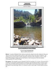
Seven Falls Hike and Swim - Feather River College
Seven Falls Hike and Swim - Feather River College
Seven Falls Hike and Swim - Feather River College

You also want an ePaper? Increase the reach of your titles
YUMPU automatically turns print PDFs into web optimized ePapers that Google loves.
Description: The area surrounding the falls is part of the Plumas National Forest <strong>and</strong> is just south<br />
of the Middle Fork of the the <strong>Feather</strong> <strong>River</strong> that leads to Lake Oroville. The elevation is about 3000<br />
ft at the camp <strong>and</strong> the area is has a mix of oak <strong>and</strong> pine as well as manzanita <strong>and</strong> other shrubs. The<br />
water temperature is cold into September but makes for nice swimming late in the summer or early<br />
fall.<br />
Directions: There are two routes that are nearly identical when driving from Quincy. You can go<br />
west along Bucks Lake road or east on LaPort road <strong>and</strong> get to <strong>Seven</strong> <strong>Falls</strong>, or you can make it a<br />
loop <strong>and</strong> take both roads. The drive is a few hours but only due to the winding roads, which are dirt<br />
at times. Below is the route using Bucks Lake road.<br />
1. Leave Quincy headed west on Bucks Lake rd.<br />
2. Continue on Oroville-Quincy Highway approx. 42 miles from Quincy<br />
3. Turn left onto Bald Rock rd for .5 miles<br />
4. Turn left onto Milsap Bar rd for 13 miles.<br />
Milsap Bar rd is dirt <strong>and</strong> rough in some places.<br />
About 5.9 miles after the bridge you will find a turn out to park <strong>and</strong> might have to<br />
search a bit for the trail head.<br />
Drive time ~2-2.5 hours<br />
http://g.co/maps/gghvy is the route mapped on google <strong>and</strong> recommended to both zoom <strong>and</strong><br />
other features to underst<strong>and</strong> the area better.<br />
<strong>Seven</strong> <strong>Falls</strong> trail:<br />
Time Needed: From parking to river is little over a mile but is very steep.<br />
Down would take 20-40 minutes, depending on how much you carry.<br />
Up will take 30-60 minutes or more, again depending on gear.<br />
Sun Exposure: All day, with significant shade.<br />
Elevation: 2600-3200 ft<br />
Rating: Trail is 2-3, steep <strong>and</strong> might require 3 points of contact for balance. Off trail is 3-4 <strong>and</strong> is<br />
risky in places.<br />
Gear Needed: For day hike:<br />
Water, lunch, sun protection, hiking shoes, hiking stick (recommended), ect<br />
For camping light weight is recommended <strong>and</strong> basic backpacking gear would be required.<br />
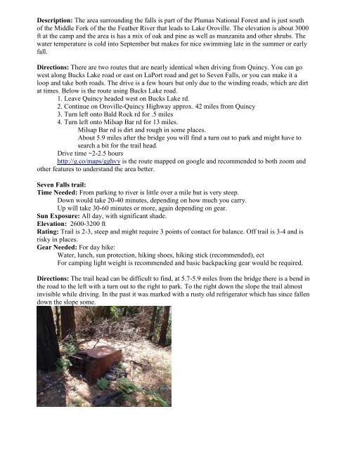
Directions: The trail head can be difficult to find, at 5.7-5.9 miles from the bridge there is a bend in<br />
the road to the left with a turn out to the right to park. To the right down the slope the trail almost<br />
invisible while driving. In the past it was marked with a rusty old refrigerator which has since fallen<br />
down the slope some.