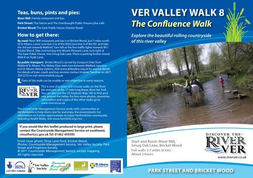
Ver Valley Walk 8 - The Confluence Walk
Ver Valley Walk 8 - The Confluence Walk
Ver Valley Walk 8 - The Confluence Walk

Create successful ePaper yourself
Turn your PDF publications into a flip-book with our unique Google optimized e-Paper software.
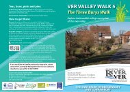
Teas, buns, pints and pies:<br />
Moor Mill : Family restaurant and bar.<br />
Park Street: <strong>The</strong> Falcon and <strong>The</strong> Overdraught Public Houses plus café.<br />
Bricket Wood: <strong>The</strong> Gate Public House (Station Road)<br />
How to get there:<br />
By road: Moor Mill restaurant and bar is in Bricket Wood, just 3 miles south<br />
of St Albans. Leave Junction 21a of the M25/Junction 6 of the M1 and take<br />
the 3rd exit towards Watford. Turn left at the first traffic lights towards M1/<br />
Bricket Wood. Take 2nd turning into Mount Pleasant Lane, turn right at<br />
<strong>The</strong> Gate Public House, into Smug Oak Lane. <strong>The</strong>re is parking further round<br />
<strong>Walk</strong> 8 on Hyde Lane.<br />
By public transport: Bricket Wood is served by transport links from<br />
Watford/St Albans. <strong>The</strong> Abbey Flyer train runs between Watford Junction<br />
and St Albans Abbey stations. Visit www.abbeyline.org.uk for service details.<br />
For details of train, coach and bus services contact Intalink Traveline on 0871<br />
200 2233 or visit www.intalink.org.uk<br />
Parts of this walk can be muddy or wet underfoot in some seasons.<br />
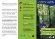
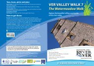
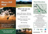
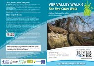
<strong>Ver</strong> <strong>Valley</strong> WALK 8<br />
<strong>The</strong> <strong>Confluence</strong> <strong>Walk</strong><br />
Explore the beautiful rolling countryside<br />
of this river valley<br />
This is one of a series of 8 circular walks on the River<br />
<strong>Ver</strong> and part of the 17 mile long linear, River <strong>Ver</strong> Trail.<br />
You can also use the OS Explorer Map 182 to find your<br />
way around the <strong>Valley</strong>. For lots more photos, memories,<br />
information and copies of the other walks go to<br />
www.riverver.co.uk<br />
<strong>The</strong> Countryside Management Service works with communities in<br />
Hertfordshire to help them care for and enjoy the environment. For<br />
information on further opportunities to enjoy Hertfordshire countryside,<br />
including Health <strong>Walk</strong>s, visit www.hertslink.org/cms<br />
If you would like this leaflet produced in large print, please<br />
contact the Countryside Management Service on southwest.<br />
cms@hertscc.gov.uk Tel: 01462 459395<br />
Front cover photo: Drop Lane Ford, Bricket Wood.<br />
Photos: Countryside Management Service, <strong>Ver</strong> <strong>Valley</strong> Society, Park<br />
Street and Frogmore Society.<br />
© 2011 Countryside Management Service, except mapping.<br />
All rights reserved.<br />
Start and finish: Moor Mill,<br />
Smug Oak Lane, Bricket Wood<br />
Full walk: 3.7 miles (6 km) -<br />
About 2 hours<br />
www.riverver.co.uk<br />
PARK STREET AND BRICKET WOOD
Discover the River <strong>Ver</strong><br />
<strong>The</strong> River <strong>Ver</strong> is special; it is a chalk<br />
stream, one of only about 200 on<br />
the planet and its pure alkaline water<br />
supports a very particular mix of flora<br />
and fauna. For 450,000 years, since the<br />
Anglian Ice Age, it has flowed (almost)<br />
uninterrupted along its valley, south<br />
from its source at Kensworth Lynch in<br />
the Chiltern Hills, through Markyate,<br />
Flamstead, Redbourn, St Albans and Park<br />
Street to where it joins with the River<br />
Colne near Bricket Wood – ultimately<br />
to empty into the River Thames near<br />
Windsor.<br />
Man has used the river for navigation,<br />
for milling, for mineral extraction and<br />
for food production – these processes<br />
mean the river is much changed from its<br />
‘natural’ state. Today we utilise the <strong>Ver</strong> in<br />
two other ways. Firstly, deep boreholes<br />
into the chalk strata (or aquifer) abstract<br />
over half of all the water that falls as rain<br />
in the area. Secondly, we use the river<br />
and its attractive surroundings for simple<br />
leisure and pleasure, by walking through<br />
its valley or along its banks, as you might<br />
do today by following this route.<br />
Like a good book, the River <strong>Ver</strong> has<br />
a beginning, middle and end, and<br />
associated with its twists and turns<br />
many characters come and go; through<br />
these walks you will follow the story<br />
in eight chapters, from source to<br />
confluence. We aim to set the <strong>Ver</strong> in its<br />
local landscape and cultural context. For<br />
further information about the <strong>Ver</strong> and<br />
the people who lived near it, past and<br />
present, visit our website: www.riverver.<br />
co.uk<br />
<strong>The</strong> River <strong>Ver</strong> links us to the past, present<br />
and future. It is...<br />
1<br />
5<br />
Moor Mill<br />
Moor Mill is mentioned in the Domesday<br />
Book. Before the Dissolution, Moremyll was a<br />
St Albans Abbey possession. From about 1400<br />
the Miller was asked to pay rent in the form of<br />
eels, caught in the waters around the mill, for<br />
the Abbey’s refectory.<br />
Hanstead House<br />
<strong>The</strong> Yule family purchased the house and<br />
estate in 1902. It was they who insisted that<br />
the nearby Colne <strong>Valley</strong> groundwater pumping<br />
stations were built in a rustic style.<br />
2 Park Street Bridge and ford<br />
A ford through the River <strong>Ver</strong> has existed here<br />
for at least 2,000 years. Nowadays the modern<br />
Watling Street/A5183 crosses on a sturdy<br />
bridge. <strong>The</strong> old Roman ford or ‘watersplash’<br />
can still be seen on its downstream side.<br />
<strong>The</strong> sand and gravel bands in Hertfordshire<br />
lie in the ‘Vale of St Albans’. This was the<br />
course of the proto-Thames which flowed<br />
approximately 2 million years ago out<br />
into the North Sea further north than<br />
the Thames does today. <strong>The</strong> bands of<br />
aggregate which overlay the chalk aquifer<br />
were deposited in vast quantities by the<br />
action of this river washed down from the<br />
Midlands. <strong>The</strong> last Ice Age diverted the<br />
Thames and <strong>Ver</strong> to their present courses.<br />
From Roman times this aggregate began<br />
to be utilised for building purposes: Sand<br />
and gravel for mortar, cement, ballast etc<br />
and flint for walls. In the 19th century, due<br />
to the Industrial Revolution and population<br />
increase, demand increased greatly. By the<br />
20th century modern machinery meant<br />
that mineral resources could be extracted<br />
on an industrial scale, this often resulted<br />
in the route and nature of the river being<br />
permanently altered, such as at Drop Lane.<br />
9<br />
Riverside Way<br />
20th century gravel extraction and subsequent<br />
‘restoration’ has greatly altered the <strong>Ver</strong>’s last<br />
mile. <strong>The</strong> river beside Drop Lane has been<br />
canalised and is a great place to see and catch<br />
Signal Crayfish.<br />
7 <strong>Confluence</strong> of the <strong>Ver</strong> with the<br />
Colne<br />
Oxford English Dictionary: ‘<strong>Confluence</strong>’ – a<br />
flowing together; the junction and union of<br />
two or more streams or moving fluids. <strong>The</strong><br />
place where two or more rivers, etc. unite.
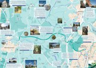
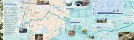
VER VAllEy WAlK 8<br />
<strong>The</strong> <strong>Confluence</strong> <strong>Walk</strong><br />
© Crown copyright and database rights 2011 Ordnance Survey 100019606<br />
3<br />
2<br />
1<br />
START<br />
4<br />
6<br />
5<br />
8<br />
7<br />
9<br />
PARK STREET AND BRICKET WOOD<br />
At Moor Mill 1 follow the footpath behind to pass under the M25. At the corner of the yard by Moor Mill Lane turn left, to follow the<br />
clear path through the former sand and gravel washing plant area to Hyde Lane, turn left.<br />
Cross the footbridge over the River <strong>Ver</strong> into Frogmore and Park Street pits 2 . <strong>Walk</strong> ahead to Branch Road, then right to Watling<br />
Street. At the river 3 turn right and, just before the bridge, turn right again onto the riverside path.<br />
Retrace the path through the pits. Look out for dragonflies and Great Crested Grebe. About 50 yards before the footbridge bear<br />
right onto a path up to the infill ridge and the site of Park Street Roman Villa. Turn left. Note how much higher the ‘restored’ land is in<br />
comparison with the river below.<br />
Cross the M25 via the footbridge; on the south side walk ahead through a kissing gate, then right and left through another area of<br />
infill to Smug Oak Lane. Cross the road to the bridleway opposite, and follow the gentle slope down to the Hanstead Ditch 4 .<br />
Follow the path left, around the perimeter of the Training College campus, past Hanstead House 5 .<br />
Follow the bridleway to Drop Lane, then turn left to see Drop Lane Pumping Station 6 . Note the gentle hum of the electric pumps.<br />
For a short detour, at the ford take the footpath, right, to see the River <strong>Ver</strong> meet the River Colne at their confluence 7 .<br />
<strong>The</strong> attractive countryside, down the Colne <strong>Valley</strong> between the confluence with the River <strong>Ver</strong> and Wall Hall/Otterspool is well worth<br />
exploring 8 . For an optional extra loop to this walk, continue beyond the confluence and cross the footbridge over the River Colne<br />
and return to Smug Oak Lane and Moor Mill on the Rights of Way via Netherwylde Farm.<br />
To return to Moor Mill from the ford walk a short distance along Drop Lane, then turn right across a footbridge to follow Riverside<br />
Way 9 , a popular permissive bridleway running alongside the river. On the drive back to Moor Mill watch out for Brown Trout<br />
and other wildlife feeding on titbits from customers.<br />
8<br />
KEy<br />
<strong>Ver</strong> <strong>Valley</strong> <strong>Walk</strong> 8 uses rights of way to link<br />
to the River <strong>Ver</strong> Trail to enable you to explore<br />
the river valley in bite size sections.<br />
Waymarking<br />
Follow these waymarks on<br />
your way around the route.<br />
<strong>Ver</strong> <strong>Valley</strong> View<br />
Public Footpath<br />
Public Bridleway<br />
Take care when crossing main roads<br />
Nature notes<br />
M E T R E S<br />
0 250 500 750 1000<br />
0 . 5 M I L E