by Derek Griffiths - Colorado Runner
by Derek Griffiths - Colorado Runner
by Derek Griffiths - Colorado Runner

Create successful ePaper yourself
Turn your PDF publications into a flip-book with our unique Google optimized e-Paper software.
Hit The Dirt...<br />
sponsored <strong>by</strong><br />
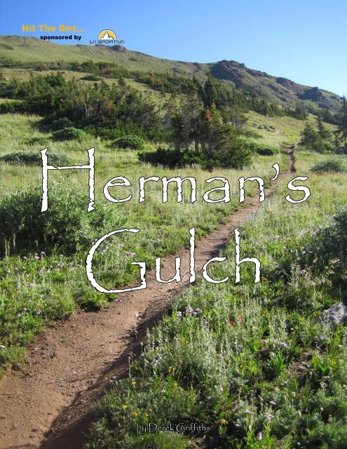
Herman’s<br />
Gulch<br />
<strong>by</strong> <strong>Derek</strong> <strong>Griffiths</strong>
I<br />
woke up on Sunday morning in late July and finally decided it was time to hit the high country for<br />
altitude training. With most of my training partners getting ready for the Leadville Trail 100, I knew<br />
it would be easy to drag a few of them along with me. But, with all of our busy schedules, I knew I had<br />
to find something close. I chose Herman’s Gulch.<br />
<strong>Derek</strong> <strong>Griffiths</strong> / <strong>Colorado</strong> <strong>Runner</strong><br />
Just a short drive up Interstate 70, this high altitude<br />
paradise is an easy 60 minute drive from Denver, but a world<br />
away. We pulled into the trailhead parking lot at 7:00 a.m.<br />
and found only two other cars. Soon we were off.<br />
Starting out at 10,200 feet, my lungs began to sizzle as soon as<br />
my feet started moving. The first two miles were an uphill grind. Luckily<br />
for me, we were going for a three hour run, so we did a lot of walking in<br />
the beginning.<br />
As we climbed up the forested trail, the howl of the freeway<br />
was slowly replaced <strong>by</strong> the gushing water coming down from the mountain<br />
runoff. In some places, we had to hop a creek and in others we high<br />
stepped through the tree roots. Amazingly, the trail was wet in some places,<br />
as if the snow had just melted.<br />
After about a mile of climbing, we rose above the tree line and<br />
into a wide, grassy meadow, displaying our first views of the towering<br />
mountains around us. The kaleidoscope of wildflowers made this view<br />
even more inspiring, and I accidentally picked up the pace. Luckily, I was<br />
running with two ultrarunners who were having no problems with either<br />
the altitude or the climbing.<br />
As we made our way through the meadow, I marveled at the yellow,<br />
purple, white and red wildflowers, with a few ba<strong>by</strong> blue Columbines<br />
thrown in for good measure. The flowers were all over the place and it was<br />
hard to look at both them and the mountains.<br />
After two miles of climbing, we came to a sign that told us the<br />
Continental Divide Trail veered to the right towards Jones Pass, while<br />
Herman’s Lake was straight ahead. I looked at my watch and found we<br />
were at 11,800 feet. We had climbed 1,600’ in two miles. That explains<br />
why my quads were on fire!<br />
We decided to continue on the CDT towards Jones Pass. As<br />
soon as we made the turn, the trail became a true high mountain single<br />
track, not nearly as heavily traveled as the Herman’s Gulch Trail. I was<br />
surprised to find that this trail actually leveled out and went down a bit<br />
before cresting a saddle and dropping down the other side. At this point<br />
I had to stop and just soak in the view. Standing on this saddle at 12,000’<br />
we could see Torreys Peak to our south and Long’s Peak to our north. We<br />
also took in the breathtaking views of the valley below before continuing<br />
down the trail, over a creek and back up the other side.<br />
At this point, the climbing started again. Once we got to the<br />
second saddle of the day, the trail turned right and began to travel across<br />
the ridge line towards Jones Pass. Up on the ridge I was glad I had brought<br />
a jacket because the wind was really howling. We stopped at a huge rock<br />
pile on the top of one of the peaks to sign in. The book inside the glass jar<br />
said we were on Hassell Peak at 13,215 feet. It had taken us one hour and<br />
40 minutes to get to here. Standing on top of this beast, we could see Torreys<br />
Peak, Mt. Evans, Mt. Bierstadt, and Long’s Peak – four of <strong>Colorado</strong>’s<br />
famed “14ers.”<br />
At this point we decided to head back towards the car, taking a<br />
side trip up to Herman’s Lake on the way back. As we traveled down the<br />
Herman’s Gulch trail, we must have passed 40 hikers coming up to the<br />
lake. Many gave us weird looks as we went flying <strong>by</strong> them on the steep<br />
trail. Back at the parking lot, every single space was full.<br />
As we drove back to Denver, all I could think about were the<br />
wildflowers, the lake and the wonderful mountain vistas we had just left.<br />
It is hard to believe that this paradise is so close the city.<br />
Editors Note: The trail distance from the trailhead to Herman’s Lake is two and a half miles one way, with an elevation gain of 2,000 feet, with a maximum<br />
of 12,400 feet. To get to Herman’s Gulch, exit I-70 at exit 218. The parking lot is on the north side of the freeway.<br />
September/October 2006 coloradorunnermag.com 69