Tornado Alley - Big Movie Zone
Tornado Alley - Big Movie Zone
Tornado Alley - Big Movie Zone

You also want an ePaper? Increase the reach of your titles
YUMPU automatically turns print PDFs into web optimized ePapers that Google loves.
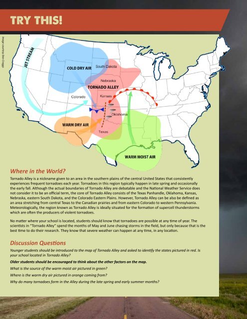
Image courtesy Dan Craggs<br />
Where in the World?<br />
<strong>Tornado</strong> <strong>Alley</strong> is a nickname given to an area in the southern plains of the central United States that consistently<br />
experiences frequent tornadoes each year. <strong>Tornado</strong>es in this region typically happen in late spring and occasionally<br />
the early fall. Although the actual boundaries of <strong>Tornado</strong> <strong>Alley</strong> are debatable and the National Weather Service does<br />
not consider it to be an official term, the core of <strong>Tornado</strong> <strong>Alley</strong> consists of the Texas Panhandle, Oklahoma, Kansas,<br />
Nebraska, eastern South Dakota, and the Colorado Eastern Plains. However, <strong>Tornado</strong> <strong>Alley</strong> can be also be defined as<br />
an area stretching from central Texas to the Canadian prairies and from eastern Colorado to western Pennsylvania.<br />
Meteorologically, the region known as <strong>Tornado</strong> <strong>Alley</strong> is ideally situated for the formation of supercell thunderstorms<br />
which are often the producers of violent tornadoes.<br />
No matter where your school is located, students should know that tornadoes are possible at any time of year. The<br />
scientists in “<strong>Tornado</strong> <strong>Alley</strong>” spend the months of May and June chasing storms in the field, but only because that is the<br />
best time to do their research. They know that severe weather can happen at any time, in any location.<br />
Discussion Questions<br />
Younger students should be introduced to the map of <strong>Tornado</strong> <strong>Alley</strong> and asked to identify the states pictured in red. Is<br />
your school located in <strong>Tornado</strong> <strong>Alley</strong>?<br />
Older students should be encouraged to think about the other factors on the map.<br />
What is the source of the warm moist air pictured in green?<br />
Where is the warm dry air pictured in orange coming from?<br />
Why do many tornadoes form in the <strong>Alley</strong> during the late spring and early summer months?