Tornado Alley - Big Movie Zone
Tornado Alley - Big Movie Zone
Tornado Alley - Big Movie Zone

Create successful ePaper yourself
Turn your PDF publications into a flip-book with our unique Google optimized e-Paper software.
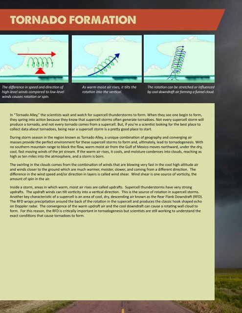
The difference in speed and direction of As warm moist air rises, it tilts the The rotation can be stretched or influenced<br />
high-level winds compared to low-level rotation into the vertical. by cool downdraft air forming a funnel cloud.<br />
winds causes rotation or spin.<br />
In “<strong>Tornado</strong> <strong>Alley</strong>,” the scientists wait and watch for supercell thunderstorms to form. When they see one begin to form,<br />
they spring into action because they know that supercell storms often generate tornadoes. Not every supercell storm will<br />
produce a tornado, and not every tornado comes from a supercell. But, if you’re a scientist looking for the best place to<br />
collect data about tornadoes, being near a supercell storm is a pretty good place to start.<br />
During storm season in the region known as <strong>Tornado</strong> <strong>Alley</strong>, a unique combination of geography and converging air<br />
masses provide the perfect environment for these supercell storms to form and, ultimately, lead to tornadogenesis. With<br />
no southern mountain range to block the flow, warm moist air from the Gulf of Mexico moves northward, under the dry,<br />
cool, fast moving winds of the jet stream. If the warm air rises, it cools, and moisture condenses into clouds, reaching as<br />
high as ten miles into the atmosphere, and a storm is born.<br />
The swirling in the clouds comes from the combination of winds that are blowing very fast in the cool high-altitude air<br />
and winds closer to the ground which are much warmer, moister, slower, and coming from a different direction. The<br />
difference in the wind speed and/or direction in layers is called wind shear. Wind shear is one source of vorticity, the<br />
amount of spin in the air.<br />
Inside a storm, areas in which warm, moist air rises are called updrafts. Supercell thunderstorms have very strong<br />
updrafts. The updraft winds can tilt vorticity into a vertical direction. This is the source of rotation in supercell storms.<br />
Another key characteristic of a supercell is an area of cool, dry, descending air known as the Rear Flank Downdraft (RFD).<br />
The RFD wraps precipitation around the back of the rotation in the supercell and produces the classic hook shaped echo<br />
on Doppler radar. The convergence of the warm updraft air and the cool downdraft can cause a rotating wall cloud to<br />
form. For this reason, the RFD is critically important in tornadogenesis but scientists are still working to understand the<br />
exact conditions that cause tornadoes to form.