NEWS - Emirates Diving Association
NEWS - Emirates Diving Association
NEWS - Emirates Diving Association

You also want an ePaper? Increase the reach of your titles
YUMPU automatically turns print PDFs into web optimized ePapers that Google loves.
<strong>NEWS</strong><br />
Thousands of Juvenile Fish Released<br />
to Sustain Abu Dhabi’s Fisheries<br />
Press Release – EAD<br />
June 27, 2010<br />
For the first time, the Environment Agency -<br />
Abu Dhabi (EAD) and the International Fish<br />
Farming Holding Company P.J.S.C. (ASMAK),<br />
a leading aquaculture company in the UAE,<br />
have released 50,000 fingerlings and juveniles<br />
of two local fish species: Hamour (Orange<br />
Spotted Grouper) and Sobaity.<br />
The fish were released as part of EAD’s Fish<br />
Stock Enhancement Programme, which aims<br />
to sustain the Emirate of Abu Dhabi’s fisheries.<br />
The fish were released in coordination with<br />
the Tourism Development & Investment<br />
Company (TDIC) off the northern coast of<br />
Saadiyat Island.<br />
Weighing between 1.2-2.0 grams, the fish were<br />
released in the early morning hours by Thabit<br />
Zahran Al Abdessalaam, Director of EAD’s<br />
Biodiversity Management Sector; Mohammed Al<br />
Muhairi, ASMAK’s Vice Chairman; Mohammed<br />
Yasin, ASMAK’s Director General and Nasser Al<br />
Shaiba, TDIC’s Environmental Director.<br />
“We have developed fisheries management<br />
plans, issued regulations to control the fishing<br />
effort and continue to regulate the conditions<br />
under which commercial fishing may occur.<br />
Despite these measures, some of our fisheries<br />
are still being overfished and that is why this<br />
release was necessary,” said Thabit Zahran Al<br />
Abdessalaam, Director of EAD’s Biodiversity<br />
Management Sector.<br />
“We are working to rebuild spawning stock<br />
biomass by augmenting the natural supply of<br />
juveniles, mitigating losses due to anthropogenic<br />
effects, supplementing fisheries that may be<br />
under pressure from fishing and improving the<br />
production from already sustainable fisheries,”<br />
he added.<br />
Al Abdessalaam said that stock enhancement<br />
programmes such as this one offer possible<br />
remediation for non-fishery related impacts<br />
on fisheries, such as ecological disruption, the<br />
pressures of development on existing fishery<br />
habitats and fishing locations.<br />
Other countries around the world have<br />
adopted similar marine stock enhancement<br />
programs such as Australia, China, Denmark,<br />
France, Iceland, Korea, Norway, Spain, Thailand,<br />
UK, USA, Japan, Iran, Canada and many island<br />
nations of Oceania.<br />
www.ead.ae<br />
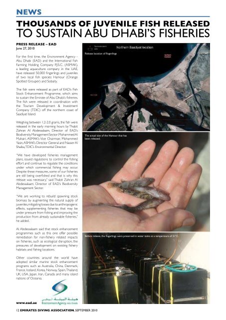
Release location of fingerlings<br />
The actual size of the Hamour that has<br />
been released.<br />
Before release, the fingerlings were preserved in water tanks at a temperature of 21°C.<br />
<strong>NEWS</strong><br />
Environment Agency – abu dhabi<br />
launches pioneering online coastal atlas<br />
Press Release – EAD<br />
Abu Dhabi, June 15, 2010<br />
• An interactive guide with an innovative<br />
online component to Abu Dhabi’s coastline<br />
and waters will support policy-making and<br />
coastal development planning, as well as<br />
educate people about the Emirate’s rich<br />
marine biodiversity<br />
• The result of two years’ work, the Atlas<br />
is the first comprehensive resource of its<br />
kind in the Gulf region and one of the most<br />
technologically-advanced in the world<br />
• The Atlas is a dynamic application which<br />
will be regularly updated ensuring current<br />
information is readily available to all<br />
• The Atlas has already won the international<br />
Environmental Systems Research Institute<br />
(ESRI) Special Achievement Award for<br />
Geographic Information Systems (GIS) in<br />
Environmental Management for 2010<br />
The Environment Agency – Abu Dhabi (EAD)<br />
has today launched its Coastal Resources<br />
Atlas and Vulnerability Index (‘Coastal Atlas’), a<br />
pioneering new resource detailing the Emirate<br />
of Abu Dhabi’s coastline and waters. The<br />
Coastal Atlas is designed to aid local policymaking<br />
and coastal development planning, as<br />
well as inform and educate people interested<br />
in the Emirate’s rich marine biodiversity.<br />
The Coastal Atlas, which is available to view<br />
online at coastalatlas.ead.ae/English, has been<br />
primarily designed as a tool to aid policy<br />
makers and development planners understand<br />
more about the Emirate’s marine environment,<br />
helping them to understand the potential impact<br />
of new policies, legislation and development<br />
decisions. The Atlas details environmental<br />
sensitivities, such as different habitats, its local<br />
biodiversity and their vulnerabilities, according<br />
to CMRECS (Coastal and Marine Resources<br />
and Ecosystem Classification System) criteria,<br />
which is internationally-recognised and<br />
considered global best-practice.<br />
As well as technical data, the Coastal Atlas<br />
also contains information about Abu Dhabi’s<br />
coastal and marine environment that members<br />
of the public will find of interest, for example<br />
locations of Marine Protected Areas. Using<br />
easy-to-use software and visually-attractive<br />
design, viewers can navigate the coastline and<br />
waters from the comfort of their armchairs.<br />
For example, people will be able to learn<br />
where the Emirate’s population of dugongs<br />
can be found, what kind of fish live in the<br />
local waters and the impact of climate change<br />
on rising sea levels in the Arabian Gulf. Most<br />
of the data is ‘open access’ online, however<br />
a second tier of the Coastal Atlas is a GISbased<br />
extension that contains commercial<br />
or sensitive information. For example, oil rig<br />
locations can only be accessed by authorised<br />
parties granted access by EAD.<br />
EAD has designed this tool to be used for<br />
environmental impact assessment by planners<br />
and developers. For example, a developer<br />
planning to dredge along the coastline will be<br />
able to map out sensitive areas containing high<br />
level of sedimentation and overlay these areas<br />
with ecological data. This mapping facility will<br />
enable developers to have access to data that<br />
will inform their decision-making.<br />
An oil spill modelling application outlines<br />
potential scenarios in the event of an oil<br />
spill in the Arabian Gulf, showing how the oil<br />
could spread out from various locations, wind<br />
and wave patterns which could influence its<br />
spread and impact on ecology. The software<br />
has also been designed to be used as a<br />
central near-real-time resource point in the<br />
event of a real oil spill, showing the tracking<br />
of the oil’s movements and helping to ensure<br />
critical information is exchanged transparently<br />
and smoothly between the<br />
organizations involved in the<br />
oil spill’s management.<br />
The Coastal Atlas has<br />
already been recognized<br />
with a global best practice<br />
award – the Environmental<br />
Systems Research Institute<br />
(ESRI) Special Achievement<br />
Award for Geographic<br />
Information Systems (GIS) in<br />
Environmental Management<br />
for 2010.<br />
Speaking at today’s launch,<br />
H.E Majid Al Mansouri,<br />
Secretary General of EAD,<br />
said: “In Abu Dhabi,<br />
we are blessed with<br />
an abundance of natural coastline and a rich<br />
marine environment which is being increasingly<br />
recognized, such as that of Bu Tinah Island. We<br />
believe that people interested in biodiversity<br />
will enjoy learning more about our local marine<br />
habitats and wildlife through this easy-to-use<br />
online tool. At EAD, we believe that interest<br />
leads to knowledge, and that knowledge leads<br />
to action. We realize that the more people<br />
know about Abu Dhabi’s unique environment,<br />
the more they will appreciate it and want to<br />
protect it.”<br />
In addition, Thabit Zahran Al Abdessalaam,<br />
Director of EAD’s Biodiversity Management<br />
Sector, said: “The Coastal Atlas is the first<br />
resource of its kind in the region, and one<br />
of the most technologically-advanced in the<br />
world today. It will function as a live database,<br />
and we are actively asking our partners to<br />
help contribute on an ongoing basis, helping<br />
to ensure that information about the marine<br />
environment is readily accessible to those who<br />
need it and that environmental considerations<br />
are prioritized.”<br />
EAD’s Introduction to the Coastal Atlas website and the map view below.<br />
12 EMIRATES DIVING ASSOCIATION, SEPTEMBER 2010 SEPTEMBER 2010, EMIRATES DIVING ASSOCIATION 13