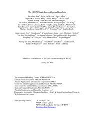
New GIS Interfaces in GrADS
New GIS Interfaces in GrADS
New GIS Interfaces in GrADS

Create successful ePaper yourself
Turn your PDF publications into a flip-book with our unique Google optimized e-Paper software.
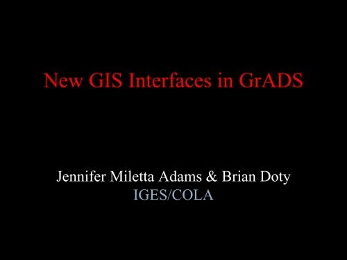
<strong>New</strong> <strong>GIS</strong> <strong>Interfaces</strong> <strong>in</strong> <strong>GrADS</strong><br />
Jennifer Miletta Adams & Brian Doty<br />
IGES/COLA
Access Shapefiles with <strong>GrADS</strong><br />
• Query the contents of a shapefile<br />
‣ get #vertices and boundaries of each element<br />
‣ list all attributes<br />
• Draw the contents of a shapefile<br />
‣ control mark type, color, and size for po<strong>in</strong>ts<br />
‣ control fill and outl<strong>in</strong>e colors for l<strong>in</strong>es/polygons
<strong>GrADS</strong> Integrates <strong>GIS</strong> and Gridded Data Formats<br />
Palmer Drought Severity Index <strong>in</strong> U.S. Climate Zones<br />
with 500mb Height Anomalies, July 1993
Create GeoTIFF with <strong>GrADS</strong><br />
• Write any gridded <strong>GrADS</strong> expression as a<br />
GeoTIFF file<br />
‣ georegistered raster image<br />
‣ control colors, levels, precision, miss<strong>in</strong>g value<br />
‣ for display <strong>in</strong> <strong>GIS</strong> tools (e.g. ArcMap, Qgis)
Create Shapefiles with <strong>GrADS</strong><br />
• Write any <strong>GrADS</strong> expression to a shapefile<br />
‣ gridded or station data<br />
• Control shapefile type<br />
‣ Po<strong>in</strong>t – grid po<strong>in</strong>t or station location<br />
‣ L<strong>in</strong>e – contours<br />
‣ Polygon – shaded contours<br />
• Add attribute metadata<br />
‣ Numeric values or character str<strong>in</strong>gs
Shapefiles from <strong>GrADS</strong> <strong>in</strong> ArcMap<br />
Grid Po<strong>in</strong>ts
Shapefiles from <strong>GrADS</strong> <strong>in</strong> ArcMap<br />
Contour L<strong>in</strong>es
Shapefiles from <strong>GrADS</strong> <strong>in</strong> ArcMap<br />
Shaded Contours
Shapefiles from <strong>GrADS</strong> <strong>in</strong> ArcMap<br />
Station Data
Create KMLwith <strong>GrADS</strong><br />
• Write any gridded <strong>GrADS</strong> expression to a KML<br />
‣ Intended for display <strong>in</strong> Google Earth<br />
• Control KML type<br />
‣ Image – creates embedded raster image file<br />
‣ L<strong>in</strong>e – contours<br />
‣ Polygon – shaded contours
OLR and Precip Data from <strong>GrADS</strong> <strong>in</strong> Google Earth