Lampson Street - Highrock Park - Township of Esquimalt
Lampson Street - Highrock Park - Township of Esquimalt
Lampson Street - Highrock Park - Township of Esquimalt

Create successful ePaper yourself
Turn your PDF publications into a flip-book with our unique Google optimized e-Paper software.
for 32 years. It is thought that architect Samuel Maclure designed the house.<br />
Alterations and additions were done by Maclure in 1917.<br />
Continue north on <strong>Lampson</strong> <strong>Street</strong>. In 1913, Philip Austin built 721 <strong>Lampson</strong><br />
<strong>Street</strong> as a wedding present for his bride Dorothy Leeming. Austin was an<br />
<strong>Esquimalt</strong> Councillor in 1916. He also served as the Acting Consul for the<br />
French Consulate.<br />
<strong>Township</strong><br />
Walking Tours<br />
Walking Tour Five: <strong>Lampson</strong> St – <strong>Highrock</strong> <strong>Park</strong><br />
Note: This walk has steep climbs.<br />
Begin the walk at <strong>Lampson</strong> <strong>Street</strong> School. The first <strong>Lampson</strong> <strong>Street</strong> School<br />
was a four-room brick building constructed in 1903. Architect William<br />
Ridgeway Wilson was hired to supervise construction. In 1909, the building<br />
was deemed too small and plans to add a second story were put in place.<br />
Architect Maxwell Muir was hired to prepare the design. The 1903 walls<br />
were found to be unsafe. A contract was awarded to Thomas Ashe to build a<br />
new eight-room school. In 1913, the plans <strong>of</strong> architect W. Ridgeway Wilson<br />
were selected for two new wings and an addition. The school reopened 9<br />
April 1914. It closed in 1976, was given heritage designation in 1990 and<br />
reopened in 1993 after being completely restored by the Greater Victoria<br />
School District. Architect and Engineer Paul Smith supervised the work. It<br />
closed again as a public school in 2007.<br />
Across the intersection on the northeast corner – 948 Old <strong>Esquimalt</strong> Road,<br />
“Brierly,” was built in 1904/05 for Richard Jones, the Inland Revenue<br />
Collector. In 1915, Norman Yarrow, the son <strong>of</strong> Sir Alfred Yarrow, purchased<br />
the house and renamed it “Fairmont.” Sir Alfred purchased the B.C. Marine<br />
Railway Co. in 1914 renaming it Yarrows Ltd. Norman managed the shipyard<br />
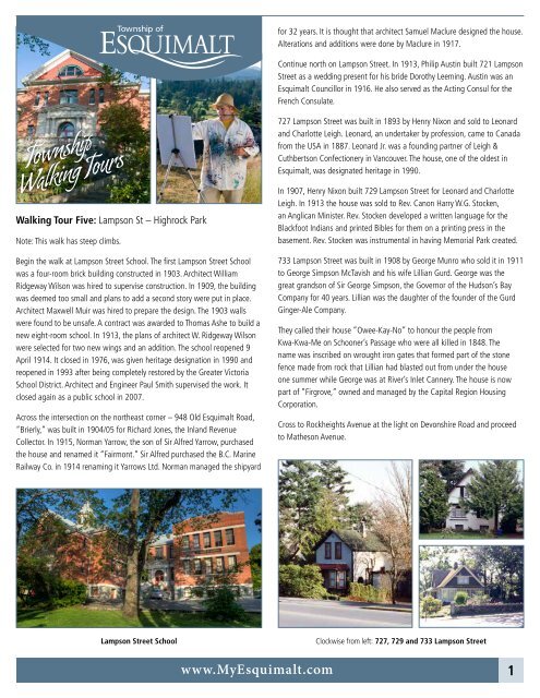
727 <strong>Lampson</strong> <strong>Street</strong> was built in 1893 by Henry Nixon and sold to Leonard<br />
and Charlotte Leigh. Leonard, an undertaker by pr<strong>of</strong>ession, came to Canada<br />
from the USA in 1887. Leonard Jr. was a founding partner <strong>of</strong> Leigh &<br />
Cuthbertson Confectionery in Vancouver. The house, one <strong>of</strong> the oldest in<br />
<strong>Esquimalt</strong>, was designated heritage in 1990.<br />
In 1907, Henry Nixon built 729 <strong>Lampson</strong> <strong>Street</strong> for Leonard and Charlotte<br />
Leigh. In 1913 the house was sold to Rev. Canon Harry W.G. Stocken,<br />
an Anglican Minister. Rev. Stocken developed a written language for the<br />
Blackfoot Indians and printed Bibles for them on a printing press in the<br />
basement. Rev. Stocken was instrumental in having Memorial <strong>Park</strong> created.<br />
733 <strong>Lampson</strong> <strong>Street</strong> was built in 1908 by George Munro who sold it in 1911<br />
to George Simpson McTavish and his wife Lillian Gurd. George was the<br />
great grandson <strong>of</strong> Sir George Simpson, the Governor <strong>of</strong> the Hudson’s Bay<br />
Company for 40 years. Lillian was the daughter <strong>of</strong> the founder <strong>of</strong> the Gurd<br />
Ginger-Ale Company.<br />
They called their house “Owee-Kay-No” to honour the people from<br />
Kwa-Kwa-Me on Schooner’s Passage who were all killed in 1848. The<br />
name was inscribed on wrought iron gates that formed part <strong>of</strong> the stone<br />
fence made from rock that Lillian had blasted out from under the house<br />
one summer while George was at River’s Inlet Cannery. The house is now<br />
part <strong>of</strong> “Firgrove,” owned and managed by the Capital Region Housing<br />
Corporation.<br />
Cross to Rockheights Avenue at the light on Devonshire Road and proceed<br />
to Matheson Avenue.<br />
<strong>Lampson</strong> <strong>Street</strong> School<br />
Clockwise from left: 727, 729 and 733 <strong>Lampson</strong> <strong>Street</strong><br />
www.My<strong>Esquimalt</strong>.com 1
Walk up Matheson Avenue and enter <strong>Highrock</strong> <strong>Park</strong> via the footpath.<br />
Cross the field and take the path to Cairn <strong>Park</strong>. At 232.25 feet, it is the<br />
highest point <strong>of</strong> land in <strong>Esquimalt</strong>. The Cairn was dedicated in 1962 during<br />
<strong>Esquimalt</strong>’s Golden Jubilee year.<br />
Municipal Engineer John Graeme designed the stone cairn and directional<br />
dais. Enjoy the wrap-around view! The Veterans’ Cemetery National Historic<br />
Site, called “God’s Acre” can be seen to the west. Access to the Cemetery is<br />
<strong>of</strong>f Colville Road. It is open daily for visitors.<br />
Return to Old <strong>Esquimalt</strong> Road by the back path to the right <strong>of</strong>f Cairn Road.<br />
This path follows the survey line that divided Viewfield and Constance Cove<br />
Farm, established in the 1850s by the Puget Sound Agricultural Company, a<br />
subsidiary <strong>of</strong> the Hudson’s Bay Company.<br />
Take the paved path south to historic Old <strong>Esquimalt</strong> Road, the oldest<br />
planned road in the west built in 1852 by the sailors <strong>of</strong> HMS Thetis under<br />
the direction <strong>of</strong> Lt. John Moresby, later Admiral Moresby. The Captain <strong>of</strong> the<br />
ship was Captain Kuper. Both men have Islands, Moresby Island and Kuper<br />
Island, named after them.<br />
Cross Old <strong>Esquimalt</strong> Road and take the path through Phil Ross <strong>Park</strong> named<br />
to honour the late Rev. Philip Ross, a United church Minister and an<br />
<strong>Esquimalt</strong> Councillor from 1983 to 1990.<br />
Turn left on Fernhill Road named for “Fernhill,” the residence <strong>of</strong> Charles E.<br />
and Elizabeth Fisher Pooley once located on 26 acres in this area. The 22-<br />
room house was demolished after a fire in 1932.<br />
Walk to <strong>Lampson</strong> <strong>Street</strong>. <strong>Lampson</strong> <strong>Street</strong> is named for the Lady <strong>Lampson</strong>, a<br />
Hudson’s Bay Company vessel.<br />
Original Fernhill, 8 rooms (top) and Expanded Fernhill, 22 rooms (bottom)<br />
In 1983 this house was the first house in <strong>Esquimalt</strong> to receive heritage<br />
designation.<br />
Return to <strong>Lampson</strong> <strong>Street</strong> School. The walk ends here.<br />
Make a left turn on <strong>Lampson</strong> <strong>Street</strong>. Across the street, 657 <strong>Lampson</strong> <strong>Street</strong>,<br />
called “Windford,” was designed by architect John Gerhard Tiarks in 1894.<br />
The first resident was Robert Milne Jeffrey, a cashier for the E&N Railway.<br />
COLVILLE RD<br />
MATHESON<br />
E&N Railway<br />
HUTCHINSON<br />
<strong>Highrock</strong> / Cairn <strong>Park</strong><br />
LAMPSON<br />
733<br />
729<br />
727<br />
ROCKHEIGHTS<br />
OLD ESQUIMALT<br />
Old HBC Survey Line<br />
<strong>Lampson</strong> <strong>Street</strong><br />
School<br />
Start / Finish<br />
CAIRN<br />
657<br />
948<br />
721<br />
OLD ESQUIMALT<br />
Phil Ross<br />
<strong>Park</strong><br />
FERNHILL<br />
View From Cairn <strong>Park</strong><br />
Written by Sherri K. Robinson. Photos: <strong>Esquimalt</strong> Municipal Archives and Josh McCulloch.<br />
Walking Tour Five: <strong>Lampson</strong> St – <strong>Highrock</strong> <strong>Park</strong><br />
2