checklist - Yarriambiack Council
checklist - Yarriambiack Council
checklist - Yarriambiack Council

Create successful ePaper yourself
Turn your PDF publications into a flip-book with our unique Google optimized e-Paper software.
Box 2: Water and soil guidance<br />
Waterway<br />
A waterway includes rivers, creeks, springs, streams and watercourses where water may occasionally<br />
flow, a lake, lagoon, swamp or marsh. Waterways are often mapped.<br />
Salinity<br />
Soil salinity occurs when the salt in the soil is brought to the surface by rising water tables. There are<br />
two aspects to this problem: recharge and discharge areas.<br />
Water that drains through the soil and reaches the watertable is called recharge. Recharge areas are<br />
generally found on hill tops. High levels of recharge increase the risk of salinity.<br />
Water leaving the groundwater is called discharge. Discharge areas are at break of slope, on or near<br />
waterways, or on flat land. A salty discharge area may have: bare areas; poor growing, stunted or<br />
yellowing plants; salt tolerant plants like sea barley grass or spiny rush; and/or a salty crust.<br />
If you are clearing vegetation in a discharge or recharge area there may be a risk of increased salinity.<br />
Some local councils have identified areas where salinity may be an issue in their planning schemes<br />
through the use of the Salinity Management Overlay (SMO). Contact your local council to see if an<br />
SMO applies to your land.<br />
Erosion<br />
Erosion occurs when soil is lost through rain, wind or the repeated movement of people, animals or<br />
vehicles. It can happen slowly over a number of years, or quickly during a storm or other extreme<br />
weather events. The risk of erosion is higher when there are steep slopes and where soils are<br />
unstable and do not absorb water.<br />
Landslip<br />
A landslip can occur when the ground is not strong enough to support its own weight, causing a<br />
slope to collapse. The risk of landslips is related to rainfall, geology, soil type and land form. Landslips<br />
occur most frequently on steep slopes but can also happen on gentle slopes.<br />
Some local councils have identified areas which are prone to erosion or landslip in their planning<br />
schemes through the use of the Erosion Management Overlay (EMO). Contact your local council to<br />
see if an EMO applies to your land.<br />
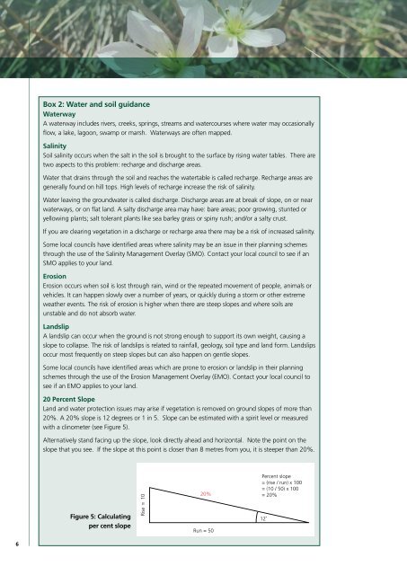
20 Percent Slope<br />
Land and water protection issues may arise if vegetation is removed on ground slopes of more than<br />
20%. A 20% slope is 12 degrees or 1 in 5. Slope can be estimated with a spirit level or measured<br />
with a clinometer (see Figure 5).<br />
Alternatively stand facing up the slope, look directly ahead and horizontal. Note the point on the<br />
slope that you see. If the slope at this point is closer than 8 metres from you, it is steeper than 20%.<br />
Figure 5: Calculating<br />
per cent slope<br />
Rise = 10<br />
20%<br />
Run = 50<br />
Percent slope<br />
= (rise / run) x 100<br />
= (10 / 50) x 100<br />
= 20%<br />
12˚<br />
6