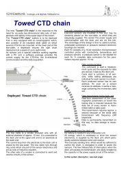
Juan Diaz Naveas (Dr. rer. nat.) - Ships
Juan Diaz Naveas (Dr. rer. nat.) - Ships
Juan Diaz Naveas (Dr. rer. nat.) - Ships

You also want an ePaper? Increase the reach of your titles
YUMPU automatically turns print PDFs into web optimized ePapers that Google loves.
Date: 5 March 2010<br />
1. General Information<br />
Application for Consent to Conduct Marine Scientific Research<br />
in Areas Under National Jurisdiction of<br />
República de Chile<br />
State Department file #<br />
1.1 Cruise name and/or #: Rapid Response<br />
1.2 Sponsoring institution: National Science Foundation<br />
Division of Ocean Sciences<br />
Address:<br />
4201 Wilson Blvd<br />
Arlington VA 22230<br />
Name of Director:<br />
<strong>Dr</strong>. Arden Bement, Jr.<br />
NSF Program Manager<br />
<strong>Dr</strong>. Richard Carlson<br />
1.3 Scientist in charge of the project (include CV and passport photo):<br />
Name:<br />
C. David Chadwell<br />
Address:<br />
University of California, San Diego<br />
Scripps Institution of Oceanography<br />
9500 Gilman <strong>Dr</strong>ive, Mail Code 0208<br />
La Jolla, California 92093 – 0208, USA<br />
Telephone: 858-534-2663<br />
Fax: 858-534-6849<br />
Email:<br />
cdchadwell@ucsd.edu<br />
1.4 Scientist(s) from coastal state involved in the planning of the project:<br />
Name(s):<br />
<strong>Juan</strong> <strong>Diaz</strong> <strong>Naveas</strong> (<strong>Dr</strong>. <strong>rer</strong>. <strong>nat</strong>.)<br />
Address:<br />
E-Mail: jdiaz@ucv.cl<br />
Escuela de Ciencias del Mar<br />
Tel.: +56-32-2274269<br />
Pontificia Universidad Catolica de Valparaiso<br />
+56-32-2274255<br />
Av. Altamirano 1480<br />
Fax: +56-32-2274255<br />
Valparaiso, CHILE<br />
Mobile:+56-9-91630936<br />
1.5 Submitting officer:<br />
Name and address:<br />
Elizabeth Brenner/Rose M. Dufour<br />
Ship Schedulers/Foreign Clearances<br />
Scripps Institution of Oceanography<br />
University of California, San Diego<br />
La Jolla, California 92093-0210<br />
USA<br />
Nationality:<br />
Telephone: (858) 534-2841<br />
Fax: (858) 822-5811<br />
Email:<br />
shipsked@ucsd.edu
2. Description of Project (Attach additional pages as necessary)<br />
2.1 Nature and objectives of the project:<br />
We are proposing to use the R/V Melville to conduct a multibeam survey of the slope above the<br />
main rupture area on the thrust fault. The seafloor above the rupture area with estimated 5.5 m<br />
of slip is 14,000 square kilometers ranging in depth from 4000 m to 400 m. Some 95% of this<br />
area, plus the trench axis (5200 m deep) could be covered in 5 days at 12 kts, with minimal,<br />
overlapping coverage. We will also deploy approximately 4 to 8 pressure sensors on the<br />
seafloor which record their depth once per minute for up to one year. If the seafloor moves<br />
abruptly again we may measure the vertical motion. This effort is time critical as subsequent<br />
motions of the slope decrease with time following the event as well as a decrease in contrast of<br />
newly disturbed seafloor. We will collaborate with <strong>Dr</strong>. <strong>Juan</strong> <strong>Diaz</strong> and personnel from IFM-<br />
GEOMAR to compare our new map with a pre-existing map collect by GEOMAR before the<br />
earthquake. We will release the data we collect with Melville immediately following the cruise<br />
to Chilean officials and the science community.<br />
2.2 Relevant previous or future research cruises:<br />
Due to the <strong>nat</strong>ure of this request, no future cruises have been planned.<br />
2.3 Previously published research data relating to the project:<br />
N/A<br />
3. Methods and Means to be Used<br />
3.1 Particulars of vessel:<br />
Name:<br />
R/V Melville<br />
Nationality (Flag state):<br />
USA<br />
Owner:<br />
Office of Naval Research<br />
Operator:<br />
Scripps Institution of Oceanography<br />
Overall length (meters):<br />
85 m<br />
Maximum draught (meters):<br />
5 m<br />
Displacement/Gross tonnage: 2,516<br />
Propulsion:<br />
Two 1385 hp Z-<strong>Dr</strong>ive<br />
Cruising & Maximum speed:<br />
11.7 knots, 14 knots<br />
Call sign:<br />
WECB<br />
Method and capability of communication Email master@rv-melville@ucsd.edu<br />
(including emergency frequencies):<br />
F77 Voice<br />
Telephone<br />
Pacific 011-872-763452498<br />
F-77 FAX<br />
Pacific 011-872-81600255637<br />
Telex 81600255637<br />
(AnsBk=WECB)<br />
Vessels guard standard GMDSS frequencies<br />
for calling, distress and dissemi<strong>nat</strong>ion of<br />
marine safety information.<br />
MMSI # 366784000<br />
SELCAL # 11024<br />
Name of master:<br />
Capt. Christopher Curl<br />
Number of crew: 23
Number of scientists on board:<br />
3.2 Aircraft or other craft to be used in the project:<br />
None<br />
3.3 Particulars of methods and scientific instruments<br />
Types of samples and data Methods to be used Instruments to be used<br />
Bathymetry and Sidescan Swath mapping with<br />
multibeam system.<br />
EM122<br />
12 kHz<br />
150 deg swath<br />
Seafloor depth Ambient sea water pressure Pressure sensors<br />
Digital Seismograms<br />
Continuous digital recording<br />
with using a ocean bottom<br />
seismographs<br />
10 OBSs will be provided by<br />
Woods Hole OBSIP<br />
instrument facilities. Each<br />
instrument will record 4<br />
channels – a 3 component<br />
broadband seismograph and a<br />
hydrophone or differential<br />
pressure gauge.<br />
Temperature, salinity,<br />
currents, partial pressure<br />
of CO2, meteorological, if<br />
available.<br />
Underway measurements<br />
from continuously<br />
pumped surface seawater<br />
and on-board sensors<br />
Thermosalinograph, acoustic<br />
doppler sonars ADCP.<br />
RDI Narrowband and RDI<br />
Broadband 150 kHz<br />
UW Mags if available. Magnetometer deployment Marine Magnetics total field<br />
gradiometer<br />
UW Gravity if available Gravimeter Bell Gravimeter<br />
3.4 Indicate whether harmful substances will be used: None<br />
3.5 Indicate whether drilling will be carried out: None<br />
3.6 Indicate whether explosives will be used:<br />
None<br />
4. Installations and Equipment<br />
Details of installations and equipment (dates of laying, servicing, recovery; exact locations and<br />
depth):<br />
Four pressure sensors will be deployed, exact location to be determined.
5. Geographical Areas<br />
5.1 Indicate geographical areas in which the project is to be conducted (with reference in latitude<br />
and longitude):<br />
5.2 Attach chart(s) at an appropriate scale (1 page, high-resolution) showing the geographical<br />
areas of the intended work and, as far as practicable, the positions of intended stations, the tracks<br />
of survey lines, and the locations of installations and equipment.<br />
See above.<br />
6. Dates<br />
6.1 Expected dates of first entry into and final departure from the research area of the research<br />
We wish to extend the current clearance approval 2009-084 through 25 March 2010.<br />
6.2 Indicated if multiple entry is expected:<br />
R/V Melville will disembark personnel and some equipment 17 March in Valparaiso <strong>Dr</strong>.
Chadwell and his party will embark R/V Melville 17 March and depart at 0800 on the 18 th of<br />
March 2010.<br />
7. Port Calls<br />
7.1 Dates and names of intended ports of call:<br />
Bahia de Valparaiso, Chile 17,18 and 25 March 2010.<br />
7.2 Any special logistical requirements at ports of call:<br />
We request fuel and provisions on the 17 th of March 2010<br />
7.3 Name/Address/Telephone of shipping agent (if available):<br />
Agent, Main Office in Valparaiso:<br />
A.J. Broom y Cia S.A.C. Errazuriz 629<br />
3er. Piso,<br />
Valparaiso<br />
Chile<br />
Tel: 56 - 32 2268200<br />
Fax: 56 - 32 2213308<br />
POC : Mario Montero / Operations Manager Broom Group<br />
Tel: 56 – 32 - 2268209<br />
Mobile: 56 9 92190462<br />
Fax: 56 – 32 - 2213308<br />
E-mail: mmontero@ajbroom.cl<br />
operations@ajbroom.cl<br />
8. Participation:<br />
8.1 Extent to which coastal state will be enabled to participate or to be represented in the research<br />
project:<br />
Please see email below from <strong>Dr</strong>. <strong>Juan</strong> <strong>Diaz</strong>-<strong>Naveas</strong>.<br />
8.2 Proposed dates and ports for embarkation/disembarkation:<br />
Embarkation 17 March, Bahia de Valparaiso, Chile<br />
Disembarkation 25 March, Bahia de Valparaiso, Chile<br />
Access to data, samples and research results<br />
9.1 Expected dates of submission to coastal state of preliminary reports, which should include the<br />
expected dates of submission of the final results:<br />
A preliminary report of the cruise and cruise data will be provided,~ 30 days after the end of the<br />
cruise.<br />
9.2 Proposed means for access by coastal state to data and samples:<br />
Data from the cruise will be provided to Chile on DVDs and also will be accessible by FTP from
servers in the United States.<br />
9.3 Proposed means to provide coastal state with assessment of data, samples and research results<br />
or provide assistance in their assessment or interpretation:<br />
A full cruise report, including expla<strong>nat</strong>ion and guides to all data sets will be provided to Chile, in<br />
final form by 01 April 2011, one year after the completion of the cruise.<br />
9.4 Proposed means of making results inter<strong>nat</strong>ionally available:<br />
Results of research will be published in peer reviewed scientific journals.<br />
-----Original Message-----<br />
From: <strong>Juan</strong> <strong>Diaz</strong>-<strong>Naveas</strong> [mailto:jdiaz@ucv.cl]<br />
Sent: Thursday, March 04, 2010 10:11 PM<br />
To: kkaiser@shoa.cl<br />
Cc: Chadwell, C. David<br />
Subject: Solicita extender permiso para buque R/V Melville<br />
Importance: High<br />
Estimada Karim:<br />
He recibido un correo electrónico del <strong>Dr</strong>. David Chadwell, de la Scripps<br />
Institution of Oceanography (Universidad de California San Diego), en el<br />
cual me manifiesta que existe la disposición a extender el actual crucero<br />
del buque de investigación Melville para efectuar un mapeo batimétrico de la<br />
zona de ruptura del reciente terremoto.<br />
El buque se encuentra operando frente a la península de Taitao. A bordo se<br />
encuentra la colega de mi Escuela de Ciencias del mar de la PUCV, la <strong>Dr</strong>a.<br />
Ximena Contardo, quien está actuando como Observador nacional.<br />
El plan de trabajo implica:<br />
- el zarpe de la nave desde Valparaíso el jueves 18 de marzo a las 08:00AM;<br />
- mapeo de la nave de la zona de ruptura (ver rectángulo en figura<br />
adjunta) usando el ecosonda multihaz del propio buque;<br />
- el arribo de la nave a Valparaíso el jueves 25 de marzo a las 08:00AM.<br />
El mapeo en cuestión permitiría descubrir probables remociones en masa o<br />
deformaciones del fondo marino que hubieran resultado, como consecuencia del<br />
terremoto del 27 de feb<strong>rer</strong>o recién pasado.<br />
El <strong>Dr</strong>. Chadwell se ha comprometido a entregar todo los datos que se obtengan<br />
durante la campaña.<br />
Para efectos de contactar directamente al <strong>Dr</strong>. Chadwell, por favor, remitirse<br />
a lo siguiente:<br />
---------------------------------------------------------------------<br />
C. David Chadwell, PhD.
Research Geophysicist<br />
Marine Physical Lab<br />
Scripps Institution of Oceanography<br />
University of California San Diego<br />
9500 Gilman <strong>Dr</strong>ive<br />
Mail Code 0205<br />
La Jolla, CA 92093-0205<br />
(e) cchadwell@ucsd.edu<br />
(p) +1-858-534-2663<br />
(f) +1-858-534-6849<br />
---------------------------------------------------------------------<br />
Por todo lo anterior, y considerando lo valioso que resulta efectuar un<br />
mapeo del fondo marino en las actuales circunstancias, solicito se le pueda<br />
extender el permiso al buque de investigación Melville para efectuar<br />
investigaciones dentro de la zona económica exclusiva de Chile.<br />
Deseando que la presente solicitud tenga favorable acogida por parte del<br />
SHOA,<br />
te saluda atentamente<br />
<strong>Juan</strong> Díaz <strong>Naveas</strong><br />
--<br />
-------------------------------------------------------------------<br />
<strong>Juan</strong> <strong>Diaz</strong> <strong>Naveas</strong> (<strong>Dr</strong>. <strong>rer</strong>. <strong>nat</strong>.) E-Mail: jdiaz@ucv.cl<br />
Escuela de Ciencias del Mar Tel.: +56-32-2274269<br />
Pontificia Universidad Catolica de Valparaiso +56-32-2274255<br />
Av. Altamirano 1480 Fax: +56-32-2274255<br />
Valparaiso, CHILE<br />
Mobile:+56-9-91630936<br />
------------------------------------------<br />
BIOGRAPHICAL SKETCH<br />
PROFESSIONAL PREPARATION:<br />
C. David Chadwell<br />
The Ohio State University, Surveying B.S., 1985<br />
The Ohio State University Civil Engineering B.S., 1985<br />
The Ohio State University Geodesy M.S., 1989<br />
The Ohio State University Geodesy Ph.D., 1995<br />
Scripps Institution of Oceanography, UCSD Post-doc., 1994-1997<br />
APPOINTMENTS:<br />
2009–present Research Geophysicist, Marine Physical Laboratory (MPL), Scripps<br />
Institution of Oceanography (SIO), University of California, San Diego (UCSD)<br />
2005–2009 Associate Research Geophysicist, MPL,SIO, UCSD<br />
2003-2005 Assistant Research Geophysicist, MPL, SIO, UCSD
1997-2003 Assistant Project Scientist, MPL, SIO, UCSD<br />
1994-1997 Post-Graduate Research Geophysicist, MPL, SIO, UCSD<br />
1992-1994 Graduate Research and Teaching Associate, Department<br />
of Geodetic Science and Surveying (DOGSS), OSU<br />
1990-1992 Graduate Research Associate, Byrd Polar Research Center (BPRC), OSU<br />
1990 Civil Engineering Assistant, P & L System Ltd., Columbus, Ohio<br />
1987 GPS Surveyor, Trimble Navigation Ltd., Sunnyvale, California<br />
1986-1990 Graduate Research and Teaching Associate, DOGSS, OSU<br />
1985 Surveyor, Franklin County Engineers Office, Columbus, Ohio<br />
1983-1984 Undergraduate Research Assistant, BPRC, OSU<br />
1982 Surveyor, U.S. Army Corps of Engineers, Huntington, West Virginia<br />
1982 Civil Engineering Intern, Ohio Department of Transportation, Delaware, Ohio<br />
SELECTED PUBLICATIONS:<br />
Chadwell, C. D. and F. N. Spiess, Plate motion at the ridge-transform boundary of the south Cleft segment<br />
of the <strong>Juan</strong> de Fuca Ridge from GPS-Acoustic data, J. Geophys. Res., 113,<br />
B04415,doi:10.1029/2007JB004936.<br />
Phillips, K. L., Chadwell, C. D. and J. A. Hildebrand, Vertical deformation measurements on the<br />
submerged south flank of Kilauea volcano, Hawai`i reveal seafloor motion associated with volcanic<br />
collapse, J. Geophys. Res., 113, B05106,doi:10.1029/2007JB005124.<br />
Gagnon, K., C.D. Chadwell, Relocation of a seafloor transponder – Sustaining the GPS-Acoustic<br />
technique, Earth Planets Space, 59, pp. 327-336, 2007.<br />
Gagnon, K., C. D. Chadwell, E. Norabuena, Measuring the onset of locking in the Peru-Chile trench with<br />
GPS and acoustic measurements, Nature, 434, pp. 205-208, 2005.<br />
Sweeney, A. D., C. D. Chadwell, J. A. Hildebrand, F. N. Spiess. Centimeter-level positioning of seafloor<br />
acoustic transponders from a deeply-towed interrogator, in press, Marine Geodesy, 28 pp. 39-70, 2005.<br />
Kussat, N. H., C. D. Chadwell, R. Zimmerman, Absolute Positioning of an Autonomous Underwater<br />
Vehicle using GPS and Acoustic Measurements, IEEE J. Oceanic Eng. 30 (1), pp. 153-164, 2005.<br />
Chadwell, C. D. Shipboard Towers for Global Positioning System Antennas, Ocean Engineering, Vol. 30,<br />
1467-1487, 2002.<br />
Chadwell, C.D., Y. Bock. Direct estimation of absolute precipitable water in oceanic regions by GPS<br />
tracking of coastal buoy, Geophys. Res. Letts., 28(19), 3701-3704, 2001.<br />
Chadwell, C.D., J.A. Hildebrand, F.N. Spiess, J. L. Morton, W.R. Normark, and C.A. Reiss. No spreading<br />
across the southern <strong>Juan</strong> de Fuca Ridge axial cleft during 1994-1996, Geophys. Res. Lett., 26(16), 2525-<br />
2528, 1999.<br />
Spiess, F.N., C.D. Chadwell, J.A. Hildebrand, L.E. Young, G.H. Purcell, Jr, and H. <strong>Dr</strong>agert. Precise<br />
GPS/acoustic positioning of seafloor reference points for tectonic studies. Physics of the Earth and<br />
Planetary Interiors, 108, 101-112, 1998.<br />
SYNERGISTIC ACTIVITIES:
Co-supervised PhD student (Sweeney) and supervised PhD students (Phillips, Gagnon) and MS student<br />
(Kussat) working on a variety of seafloor geodesy/geophysics projects. Support one summer<br />
undergraduate intern each summer. Acted as Chief or Co-Chief Scientist aboard ~12 cruises during the past<br />
7 years. Have included aboard the cruises intern, 2-3 volunteers from the Stephen Birch Aquarium, 2-3<br />
undergraduate science students and occasionally inter<strong>nat</strong>ional scientists (Peru) to expose them to sea-going<br />
research. Provide guidance and build equipment for researchers in Japan and France to conduct seafloor<br />
geodetic research. Serve on SIO Marine Operations Committee and Marine Sciences Physical Planning<br />
Committee. Served as Chair of the IEEE-Ocean Engineering Society Technical Committee on<br />
Communications, Navigation and Positioning from 2002 to 2007. Co-teach SIO 226 – Introduction to<br />
Marine Geophysics.<br />
COLLABORATORS AND OTHER AFFILIATIONS<br />
Collaborators and Co-Editors (last four years): E. Norabuena, H. <strong>Dr</strong>agert, H. Fujimoto, S. Miura, R.<br />
Burgmann, N. Seeber, M. Cormier, W. Chadwick, B. Brooks<br />
Graduate/Post-graduate Advisor:<br />
Fred N. Spiess (Post-doctoral, SIO)<br />
Clyde C. Goad (Ph.D, The Ohio State University)<br />
Graduate Student Advisor:<br />
Aaron Sweeney Ph.D (2001) , Neil Kussat M.S. (2004, Chair), Kathleen Phillips PhD. (2006, Co-<br />
Chair), Katie Gagnon PhD. (2007, Chair).<br />
-------------------------