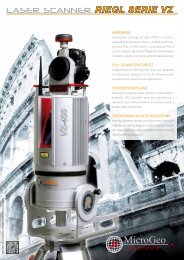
RIEGL VQ-820-G
RIEGL VQ-820-G
RIEGL VQ-820-G

You also want an ePaper? Increase the reach of your titles
YUMPU automatically turns print PDFs into web optimized ePapers that Google loves.
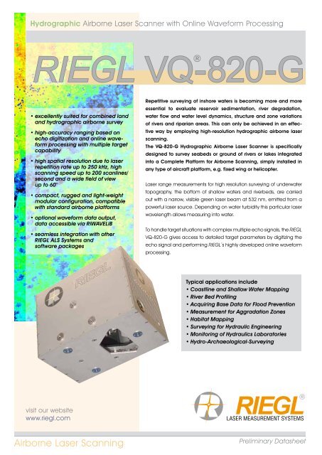
Hydrographic Airborne Laser Scanner with Online Waveform Processing<br />
<strong>RIEGL</strong> <strong>VQ</strong>-<strong>820</strong>-G<br />
®<br />
••<br />
excellently suited for combined land<br />
and hydrographic airborne survey<br />
••<br />
high-accuracy ranging based on<br />
echo digitization and online waveform<br />
processing with multiple target<br />
capability<br />
••<br />
high spatial resolution due to laser<br />
repetition rate up to 250 kHz, high<br />
scanning speed up to 200 scanlines/<br />
second and a wide field of view •<br />
up to 60°<br />
••<br />
compact, rugged and light-weight<br />
modular configuration, compatible<br />
with standard airborne platforms<br />
••<br />
optional waveform data output,<br />
data accessible via RiWAVELiB<br />
••<br />
seamless integration with other<br />
<strong>RIEGL</strong> ALS Systems and •<br />
software packages<br />
Repetitive surveying of inshore waters is becoming more and more<br />
essential to evaluate reservoir sedimentation, river degradation,<br />
water flow and water level dynamics, structure and zone variations<br />
of rivers and riparian areas. This can only be achieved in an effective<br />
way by employing high-resolution hydrographic airborne laser<br />
scanning.<br />
The <strong>VQ</strong>-<strong>820</strong>-G Hydrographic Airborne Laser Scanner is specifically<br />
designed to survey seabeds or ground of rivers or lakes integrated<br />
into a Complete Platform for Airborne Scanning, simply installed in<br />
any type of aircraft platform, e.g. fixed wing or helicopter.<br />
Laser range measurements for high resolution surveying of underwater<br />
topography, the bottom of shallow waters and riverbeds, are carried<br />
out with a narrow, visible green laser beam at 532 nm, emitted from a<br />
powerful laser source. Depending on water turbidity this particular laser<br />
wavelength allows measuring into water.<br />
To handle target situations with complex multiple echo signals, the <strong>RIEGL</strong><br />
<strong>VQ</strong>-<strong>820</strong>-G gives access to detailed target parameters by digitizing the<br />
echo signal and performing <strong>RIEGL</strong>´s highly developed online waveform<br />
processing.<br />
Typical applications include<br />
••<br />
Coastline and Shallow Water Mapping<br />
••<br />
River Bed Profiling<br />
••<br />
Acquiring Base Data for Flood Prevention<br />
••<br />
Measurement for Aggradation Zones<br />
••<br />
Habitat Mapping<br />
••<br />
Surveying for Hydraulic Engineering<br />
••<br />
Monitoring of Hydraulics Laboratories<br />
••<br />
Hydro-Archaeological-Surveying<br />
visit our website<br />
www.riegl.com<br />
Airborne Laser Scanning<br />
Preliminary Datasheet
Key Features <strong>RIEGL</strong> <strong>VQ</strong> ® -<strong>820</strong>-G<br />
Design<br />
The <strong>RIEGL</strong> <strong>VQ</strong>-<strong>820</strong>-G consists of an unrivalled compact and lightweight<br />
scan head connected to a powerful laser source via an amored glass<br />
fiber cable and electrical cables, allowing easy installation into existing<br />
and certified airborne scanning platforms and hatches of standard size<br />
with similar key data for Fit, Form & Function, as well as in terms of power<br />
supply requirements and weight & balance considerations - total weight<br />
is approx. 30 kg, power consumption is approx. 220 W.<br />
photo courtesy of AHM<br />
www.ahm.co.at<br />
The scan mechanism of the <strong>VQ</strong>-<strong>820</strong>-G is based on a rotating multifacet<br />
mirror where the scan axis is tilted by about 20° with respect to<br />
the nominal flight direction, so that the angle of incidence of the laser<br />
beam to the water surface varies only by about 1° over the entire scan<br />
range of up to 60°. This results in an arc-like scan pattern on ground.<br />
photo courtesy<br />
of AHM<br />
www.ahm.co.at<br />
Aiming at high resolution, the laser scanner emits a narrow beam of<br />
about 1 cm diameter with a beam divergence in the range of 1 mrad.<br />
Therefore, at the nominal flight altitude of 500 m, the spatial resolution<br />
as defined by the laser beam geometry is in the range of 50 cm. High<br />
spatial resolution is also supported by an exceptionally high net measurement<br />
rate of 110,000 measurements per second.<br />
Echo Analysis<br />
The incoming echoes are digitized at a sampling rate matched to the<br />
pulse width. The instrument is equipped with online waveform processing.<br />
Concurrently echo waveform data can be stored for full waveform<br />
post processing by means of the optional waveform data output.<br />
For each trigger event a so called sample block containing a certain<br />
number of samples before and after the trigger event is recorded.<br />
For every target echo, the position, amplitude, and pulse deviation are<br />
determined. If the echo pulse is severely deteriorated by turbidity or<br />
multi-target returns, this will be signaled through an increased value of<br />
the scanner’s pulse deviation reading and the corresponding waveform<br />
can then be analyzed with more sophisticated algorithms if requested.<br />
Considering Refraction<br />
Refraction is taken into account during post processing of the data<br />
with the well known and acknowledged <strong>RIEGL</strong> ALS software package<br />
RiPROCESS. After georeferencing the acquired pointclouds, the water<br />
surface is determined and targets below the water surface are shifted to<br />
the correct position according to refraction of the echo (beam bending<br />
and waveform compression). The water surface can be defined as a<br />
simple plane but may also be represented by a triangulated model<br />
acquired from the laser scan data.<br />
2 Preliminary Datasheet
Main Dimensions<br />
Complete Platform <strong>RIEGL</strong> CP-<strong>820</strong>-G<br />
Complete Platform System<br />
for Hydrographic Airborne Scanning<br />
Preliminary Datasheet<br />
3
<strong>RIEGL</strong> <strong>VQ</strong> ® -<strong>820</strong>-G Scan Head & Laser Unit<br />
Main Dimensions<br />
Scan Head<br />
Laser Unit<br />
4 Preliminary Datasheet
Example Project <strong>RIEGL</strong> <strong>VQ</strong> ® -<strong>820</strong>-G<br />
Floodplain Area Alongside the Danube<br />
A small floodplain area alongside the Danube in Lower Austria was<br />
chosen where several waterbodies of different size and depth are<br />
available. The waterbodies were partly covered with a thin layer of ice.<br />
At windless conditions, the water surface was perfectly flat.<br />
<strong>VQ</strong>-<strong>820</strong>-G measurements were performed from a helicopter<br />
platform at the following parameters:<br />
Operating altitude:<br />
Ground speed:<br />
Laser pulse repetition rate:<br />
Scanning rate:<br />
Resulting point density:<br />
125 m AGL<br />
25 knots<br />
138kHz<br />
70 lines/second<br />
50 meas./square meter<br />
Snapshot from a nadir-pointed video camera also showing the thin ice<br />
layer and several power lines going over the waterbody.<br />
Bird‘s-eye-view of the<br />
flight strip with and without<br />
subaqueous points as<br />
well as the power lines.<br />
The point cloud of the<br />
power lines with masts<br />
gives a good impression<br />
of the very high measurement<br />
resolution.<br />
Cross section indicating targets above water level,<br />
subaqueous points, natural land targets and power lines.<br />
Preliminary Datasheet<br />
5
Technical Data <strong>RIEGL</strong> <strong>VQ</strong> ® -<strong>820</strong>-G<br />
Laser Product Classification<br />
Class 3B Laser Product according to IEC60825-1:2007<br />
The following clause applies for instruments delivered into the United States: Complies with<br />
21 CFR 1040.10 and 1040.11 except for deviations pursuant to Laser Notice No. 50, dated June 24, 2007.<br />
Safe for the naked eye<br />
Safe for the aided eye<br />
Range Measurement Performance<br />
Measuring Principle<br />
Topography (diffusely reflecting targets)<br />
Max. Measurement Range 1)<br />
natural targets ≥ 20 %<br />
natural targets ≥ 60 %<br />
Typ. Operating Flight Altitude AGL 2)<br />
Hydrography<br />
Typ. Measurement Range 3)<br />
Minimum Range<br />
4) 6)<br />
Accuracy 25<br />
5) 6)<br />
Precision 25<br />
Laser Pulse Repetition Rate<br />
Max. Effective Measurement Rate<br />
Echo Signal Intensity<br />
Number of Targets per Pulse<br />
Laser Wavelength<br />
Laser Beam Divergence<br />
Laser Beam Footprint (Gaussian Beam Definition)<br />
1) The following conditions are assumed:<br />
target larger than the footprint of the laser beam, average ambient<br />
brightness, visibility 23 km, ambiguity to be resolced by<br />
proper flight planning and multiple-time-around processing<br />
2) Reflectivity ≥ 20%, 42° FOV, additional roll angle ±5°<br />
100 m<br />
500 m<br />
time of flight measurement, echo signal digitization,<br />
online waveform processing<br />
2000 m<br />
3000 m<br />
600 m (1970 ft.)<br />
1 Secchi depth<br />
10 m<br />
mm<br />
mm<br />
up to 250 kHz<br />
up to 110 000 meas./sec. (@ 250 kHz PRR & 42° FOV)<br />
for each target, high-resolution 16 bit intensity information is provided<br />
unlimited (digitized waveform processing)<br />
green<br />
1.0 mrad<br />
100 mm @ 100 m, 1000 mm @ 1000 m<br />
Scanner Performance<br />
Scanning Mechanism<br />
rotating multi-facet mirror<br />
Scan Pattern<br />
section of an ellipse<br />
Field of View (selectable)<br />
42°, max. 60° (with reduced measurement range)<br />
Scan Speed (selectable)<br />
50 - 200 scans/sec<br />
Angular Step Width (selectable)<br />
≥ 0.09° (for PRR 250 000 Hz)<br />
between consecutive laser shots<br />
Angle Measurement Resolution 0.001°<br />
Data Interfaces<br />
Configuration<br />
Scan Data Output<br />
GNSS Interface<br />
Mechanical Interfaces<br />
Mounting of Scan Head<br />
Mounting of IMU Sensor<br />
3) The Secchi depth is defined as the depth at which a standard black and white disc deployed into the<br />
water is no longer visible to the human eye.<br />
4) Accuracy is the degree of conformity of a measured quantity to its actual (true) value.<br />
5) Precision, also called reproducibility or repeatability, is the degree to which further measurements show<br />
the same result.<br />
6) Topography, one sigma @ 150m range under <strong>RIEGL</strong> test conditions.<br />
LAN 10/100/1000 Mbit/sec<br />
LAN 10/100/1000 Mbit/sec<br />
Serial RS232 interface for data string with GNSS-time information,<br />
TTL input for 1PPS synchronization pulse<br />
3 x M8 thread inserts in the base plate<br />
3 x M8 thread inserts at both sides of the housing<br />
(rigidly coupled with the internal mechanical structure)<br />
General Technical Data Scan Head Laser Unit<br />
Power Supply Input Voltage 18 - 32 V DC 18 - 32 V DC (with external converter)<br />
Current Consumption typ. 65 W typ. 140 W<br />
Main Dimensions 360 x 232 x 277 mm 260 x 270 x 87 mm<br />
Weight 20.5 kg approx. 10 kg<br />
Humidity<br />
non condensing<br />
Protection Class Scan Head<br />
IP54, dust and splash-proof<br />
Max. Flight Altitude (operating) 7)<br />
16 500 ft (5 000 m) above MSL<br />
Max. Flight Altitude (not operating)<br />
18 000 ft (5 500 m) above MSL<br />
Temperature Range<br />
0°C up to +40°C (operation) / -10°C up to +50°C (storage)<br />
7) For standard atmospheric conditions:<br />
1013 mbar at sea level, +15°C<br />
Note: The <strong>VQ</strong>-<strong>820</strong>-G is subject to export restrictions.<br />
It is listed under category 6A008j3. in Annex I of Council Regulation 428/2009.<br />
Information contained herein is believed to be accurate and reliable. However, no responsibility<br />
is assumed by <strong>RIEGL</strong> for its use. Technical data are subject to change without notice.<br />
<strong>RIEGL</strong> Laser Measurement Systems GmbH, 3580 Horn, Austria<br />
Tel.: +43-2982-4211, Fax: +43-2982-4210, E-mail: office@riegl.co.at<br />
<strong>RIEGL</strong> USA Inc., Orlando, Florida 32819, USA<br />
Tel.: +1-407-248-9927, Fax: +1-407-248-2636, E-mail: info@rieglusa.com<br />
<strong>RIEGL</strong> Japan Ltd., Tokyo 1640013, Japan<br />
Tel.: +81-3-3382-7340, Fax: +81-3-3382-5843, E-mail: info@riegl-japan.co.jp<br />
www.riegl.com<br />
Preliminary Data sheet, <strong>RIEGL</strong> <strong>VQ</strong>-<strong>820</strong>-G, 22/09/2011